Embed Size (px)
Citation preview

MARYLAND HISTORICAL TRUST ADDENDUM SHEET INTERCOUNTY CONNECTOR PROJECT
Property Name: Jacob VanHorn Farmhouse Survey No. M:27-9 (PACS C3.1)
Property Address 14821 Layhill Road, Layhill. Montgomery Countv. Maryland 1- Owner Name/Address Frank & Anne Willson Jr .. 14821 Layhill Road. Silver Spring, MD 20906
Year Built circa 1885
Description:
The Jacob VanHorn Farmhouse, constructed circa 1885, was previously surveyed by the M-NCPPC and the Montgomery County Historic Preservation Commission in 1974, 1976, 1982, and 1991. Since the time of the previous survey, neither the property, nor its setting, has been altered.
National Register Evaluation:
The Jacob VanHorn Farmhouse, constructed circa 1885, is not eligible for the National Register of Historic Places. The property is not eligible under Criterion A or 8, as it has no known association with historically significant persons or events. It does not meet Criterion C, as the architectural integrity of the house has been severely compromised by additions on the side and rear, and construction of a brick veneer on the front facade. In addition, the property is not eligible under Criterion D, as the property has no known potential to yield important information.
MHT CONCURRENCE: Eligibility _Recommended XNot recommended Criteria A B C D Considerations _A _B _c _D _E _F _G _None Comments: - - -
Preparer: P.A.C. Spero & Company October 1996
erv1ces


~Ill~~~'?! 4- C14-U?~ k~
7 .:6J,.~ 199& r, !PAC: JpU-O ~ ~'Y" ~ klJ
I ? va~ /A:inlic-zA-~fl( !Lou.re_,/ 14-.?~ I i.ay/-ull l?P/,, . {- ~1 I ffirade-
8 1/4

I llJ-21--CJ i.. Ja.co'7 11w4kuL 1at1~
3 mun7ern~ ~"{y 4-'Li~t~~ c:; d-eh--~ 19'1b
f:.fe J'puo~d ~'2¥' ~Iii> 1--:;-.)o~ !/tV' lfaoz f auu~
I !+Si1 I ~/vii :ea~ llJ/.&:Jf ~tJ11-8 Z./4-

, 1n- i1-1 ~ 0 ~V~' IJi' 1'i())j\ }OvlllJu ttJL..
~ /Jlon:f~l~ d11~~ 4-" {,~/,~ flAlt-
5 7-iArt,(~ 1~6 74'((J ~ aAd a'>¥01J / ~n A.lb
7(Mc,d, £tt,t 1-1-oVL 7at/J.IJO~ /4FZ I /~tu/. @.) add1 lto1t._
8 ~/4-


I 111- 1-'1- q 2 Ua~b vfuz'/-tc11t fa(/JttlE~
3 llltrn~:# 6>~ 4 c!a-ut~ llt:L/L ~ Ti1'~ 1'19b :,, ?/le Spew t:A:;/d &7¥4~ 0Udt>n/Jlb 7 d~ ~1 i-le-uL 'latr}(h.ou.t~ /.;ffZ.I .t~~//! 'W ~~~"
../
16 4 /4-

Capsule Summary
Jacob VanHorn Farmhouse
JiJrE 1991
Mont. Co. survey pref ix 27 Site number 9
Approx. building date c. 1885 Town/town vicinity Silver Spring Access Public I Private
Short Description of Site:
This is an 1885 fanTihouse which retains its original setting with la~ge trees and meadows, but which has been altered quite extensively. It does retain its original smoke house, spring house, and a 1927 dairy building. The house was originally a three-bay, two-story frame building with an ell behind on the west. The original weatherboarded facade has been brick veneered. Brick additions have been ma.de to the east (1970s) and south {1980s) . The house retains its original smoke house with a lapped shake roof, mostly original mortar, board and batten door with stone lintel, and dirt floor. It is situated near the house on the southeast. The spring house, built in the 1930s at the west side of the rna.n-made pond, was used u.~til 1986.

Analysis of Evaluation
fQl;_
Jacob VanHorn Farmhouse (27/9)
Value Descr.
Outstanding
ConsiderablE
Moderate
Minor
Evaluation Criteria
~
Arch. Sign if.
"" Arch. Integrity
~
June 1991
I I
Historical Sign if.
Rating for this site: Minimal
Criteria:
Rating
Procedure:
# of Boxes Selected x 1 00 12
O - 25 % = Unqualified 25 - 50 % = Minimal 50 - 75 % = Mid-level 75 -100% =Good 90 - 100% = Natl. Reg. (with
possible exceptions~
Arch stgnif]cance - that quality which embodies the distinctive characteristics of a type, period, or method of construction, or that represent the work of a master, or that
~.possess high artistic values, or that represent a significant and distinguishable entity whose component may lack individual distinction.
Historical Signjf]cance - that quality present in sites associated with events that have made a significant contribution to the broad patterns of our history; or that are associated with the lives of persons significant in our past; or that have yielded, or may be likely to yield, information important in history.
Arch Intearjty - determined by the number of architectural changes to the site ... using the following list as a guide ... {and) noting other unusual changes.
Detrimental Changes (depending on the quality of its original character) :
new or relocated chimney rebuilt foundation new porch original windows changed (at a later, but still historical, date) modern windows in original frames original windows intact but extra ones added change in shape or size of window openings lack of outbuildings aluminum siding (unless original architraves and trim are retained) asphalt or asbestos siding (over original siding) recent change of location
Critical Changes· aluminum siding added; architraves eliminated additions engulfing or removing portions of original building
:sz.a.Jue Descriptions
Ontstandjng - distinguished; of particular import. to Md. historic & arch. past.
Considerable - deserving of recognition; contributes to the understanding of history or ~architectural heritage represented in Maryland
Moderate - commonality ... lack of historic signif. or arch. style, except if scarce
Minn.I: - unimportant or inferior; little arch. worth and absence of hist. importance

Site Information Summary
for
Jacob VanHorn Farmhouse
June 1991
Site number :27/9
Co. tax account number :984351 Street address : 14821 Layhill Road
Name of property owner Addr. of property owner
Silver Spring, Maryland
: Frank F. Willson, Jr. : 14821 Layhill Road
20906
Silver Spring, Maryland 20906
Historic Preservation Master Plan Recomm.endation:
Historic Preservation Ordinance Criteria
(1) Historical and cultural significance. The historic resource:
_l_ a. Has character, interest or value as part of the development, heritage or cultural characteristics of the county, state or nation;
b. Is the site of a significant historic event; c. Is identified with a person or group of persons who influenced
society; d. Exemplifies the cultural, economic, social, political or historic
heritage of the county and its cormnunities.
{2) Architectural and design significance. The historic resource:
_l_ a. Embodies the distinctive characteristics of a type, period, or method of construction;
b. Represents the work of a master; c. Possesses high artistic values; d. Represents a significant and distinguishable entity whose components
may lack individual distinction; or _l_ e. Represents an established and familiar visual feature of the
neighborhood, community or county due to its singular physical characteristic or landscape.
Enviro.n.m_ental Setting Recommendation:
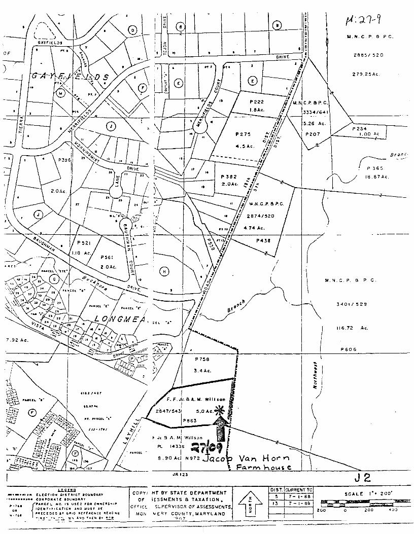
The environmental setting should include the entire parcel (p 863) of 5 acres.

M ... · ""n-Cf survey Ne. ti- 1 I
Maryland Historical Trust Magi No.
State Historic Sites lnventery Fera DOE __yes no
1. Name {.indicate preferred name}
historic Jacob VanHorn Farmhouse
and/or common Frank Willson Place
2. Location street & number 14821 Layhill Road _ not for publication
city, town Silver Spring _ vicinity of congressional district 8
state Maryland Montgomery county
3. Classification Category __ district-~- building(s) __ structure _site _object
Ownership _public ~private _both Public Acquisition _in process _ being considered
___K."_not applicable
Status x occupied
_ unoccupied _ work in progress Accessible _ yes: restricted _yes: unrestricted _K__ no
Present Use _ agriculture _ commercial _ educational _ entertainment _ government _ industrial _military
_museum _park ~ private residence _religious _ scientific _ transportation _other:
4. Owner of Property (give names and mailing addresses of~ owners)
name Frank & Anne Willson
street & number 14821 Layhill Road (301) 598-6063 telephone no.:
city, town Silver Spring state and zip code Maryland 20906
5. Location of Legal Descriptio;n
courthouse, registry of deeds, etc. Montgomery County Courthouse liber 2847
street & number folio 543
city, town RocJ.:ville state Maryland
6. Representation in Existing Historical surveys
title Maryland National Capitol Park & Planning Commission Historic Sites Inventoq
date 1976 x x _ federal _ state _ county __ local
deposit:!Jry for survey records Maryland National Capital Park & Planning Commission
city, town 8787 Georgia Avenue, Silver Spring state Maryland

Condition -1L excellent _good _fair
Check one _ deteriorated __ unaltered _ ruins _x_ altered _unexposed
Check one -~ original site _moved date of move
Prepare both a summary paragraph and a general description of the resource and its various elements as it exists today.
summa.:r:y: This is an 1885 far:mhouse which retains its original setting with large trees and meadows, but which has been altered quite extensively. It does retain its original smoke house, spring house, and a 1927 dairy building. A county park abuts the property on the east, but a road interchange is planned for the meadow behind the house; if constructed, the road would seriously impact the site's.
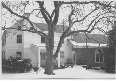
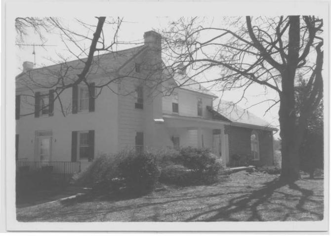
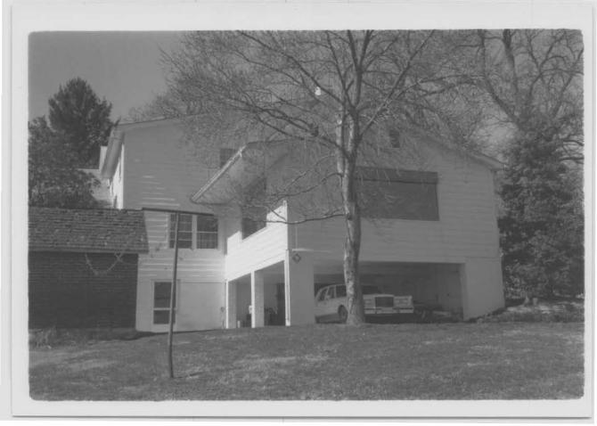
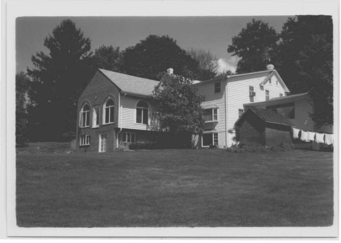
Description: The house was originally a three-bay, two-story frame building with an ell behind on the west. The original weatherboarded facade has been brick veneered. Brick additions have been made to the east (1970s) and south (1980s). The roof has asphalt shingles. Windows in the original building are 6/6, with 4/4 windows in the gables. There is dentilling under the gables. Picture windows have been put in the additions. The house has three corbelled chimneys: one square chimney through the roof at the east end of the main block and a large rectangular exterior chimney at the west end; a third large fireplace chimney at the original end of the ell has been enclosed. by the recent construction of a large two-story addition. Sane of the original stone foundation with original mortar remains under the ell in what used to be a potato cellar. The original wrap-:-around front porch has been removed. The central front door has a transom and side lights with diamond panes.
The central hall in the original structure contained stairs going to the second floor. It continued back to the kitchen in the ell. A parlor was on the left and a dining room on the right as one entered the house. The house received plumbing and electricity in 1930.
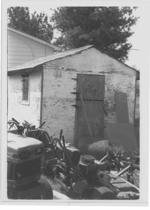
Outbuildings: The house retains its original smoke house with a lapped shake roof, mostly original mortar, board and batten door with stone lintel, and dirt floor. It is situated near the house on the southeast. The original two-story barn was struck by lightening and burned. The current one-story barn replaced it. An ice house stood to the northeast of the house, between the house and the barn. To the north of the ice house, where there is now a small house, was a buggy shop.
The spring house, built in the 1930s at the west side of the man-made pond, was used until 1986. It had a ram and wheel device that would send water to the barn to automatically water the 100 dairy cows on the fa:rm.
Researcher: susan Escherich, May 8, 1991.

8. Significance Survey No. u: -:27-9
Period _ prehistoric _ 1400-1499 -1500-1599
Areas of Significance-Check and Justify below - archeology-prehistoric _ community ptanntng _landscape architecture_ religion - archeology-historic _ conservation _law _science _agriculture _economics _ fiterature _ sculpture
-- 1600-1699 ~architecture _education _military _ social/ _ 1700-1799 -1L 1800-1899 _1900-
Specific dates
_art _commerce _ communications
c. 1885
check: Applicable Criteria: and/or
Applicable Exception:
Level of Significance:
- engineering _ music humanitarian ~ exploration/settlement _ philosophy _ theater - industry _ politics/government _ transpol"tation - invention _other (specify)
Builder/Arcbitect Henry K. Vanhorn (?)I ---
A B c D
A B c D E F G
national state local -Prepare both a summary paragraph of significance and a general statement of history and support.
"The Jacob VanHorn fa:r:mhouse (c.18851), one of the few remaining old homes
in the Layhill area, is significant as an example of vernacular architecture typical of that constructed in Montgomery County from the mid-nineteenth through the early twentieth centuries."2
1. Historic Period Theme(s):Architecture/Landscape Architecture/ Community Planning
2. Geographic Organization: Piedmont (Montgomery County) 3. Developnent Period: Industrial/Urban Dominance 1870-1930 A.D. 4. Resource Type(s): Livestock/dairy fanns
"Development in the Aspen Hill area of Montgomery County began with a 3,860 acre land grant called "Lay Hill" in 1689. A second grant of 4,892 acres was made in 1718. Over time, these and subsequent grants were broken down to create fanns of several hundred acres each. 3 The house is believed to have been built by Henry K. Vanhorn who, according to the map of 1865, lived on this site in an earlier dwelling. (Nineteenth century VanHorn grave sites can be found in the nearby Layhill M.E. Church cemetery.) The land consisted of approximately 220 acres of a tract of land referred to as 'Layhill', and was part of the homeplace of Richard Holmes, deceased. 4
"In May of 1884, Henry mortgaged the property to Beulah Thomas. He later defaulted and the property was sold in October of 1888. The notice of sale described it as a fann of approximately 2057 /e acres located directly on the
(cont.) ' Date given is based on the date that the land was purchased and the fact that it was described as a "new" house in 1888. 2 Catherine Crawford, Maryland Historical Trust, 'State Historic Sites Inventory Form', M-NCPPC, 10/82. 3 Maryland National Capitol Park & Planning Commission, "Planning Area Diagnosis: Aspen Hill and Vicinity", (Silver Spring, Maryland: M-NCPPC, 1967) p.10. 4 Deed EBP 211305, Montgdmery County Land Records.
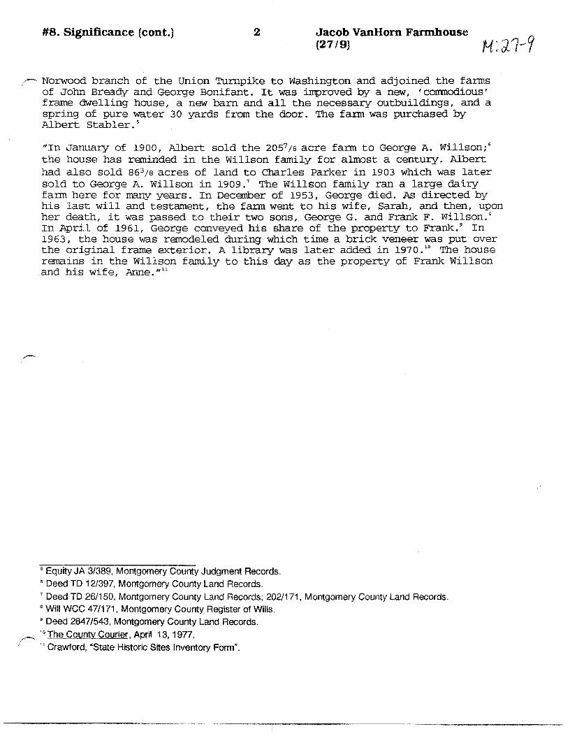
#8. Significance (cont.) 2 Jacob VanHom Farmhouse (27 /9) H: Jl-Y
,~ NoIWood branch of the Union Turnpike to Washington and adjoined the f ar:ms of John Bready and George Bonifant. It was improved by a new, 'comnodious' frame dwelling house, a new barn and all the necessary outbuildings, and a spring of pure water 30 yards from the door. The fann was purchased by Albert Stabler. s
"In January of 1900, Albert sold the 2057 /s acre fann to George A. Willson; 6
the house has reminded in the Willson family for almost a century. Albert had also sold 863/s acres of land to Charles Parker in 1903 which was later sold to George A. Willson in 1909. 7 The Willson family ran a large daii-y farm here for many years. In December of 1953, George died. As directed by his last will and testament, the fa:rm went to his wife, Sarah, and then, upon her death, it was passed to their two sons, George G. and Frank F. Willson.a In April of 1961, George conveyed his share of the property to Frank. 9 In 1963, the house was remodeled during which time a brick veneer was put over the original frame exterior. A library was later added in 197 o. 10 The house remains in the Willson family to this day as the property of Frank Willson and his wife, Anne." 11
5 Equity JA 3/389, Montgomery County Judgment Records. " Deed TD 12/397, Montgomery County Land Records. 1 Deed TD 26/150, Montgomery County Land Records; 202/171, Montgomery County Land Records. s Will WCC 47/171, Montgomery County Register of Wills. • Deed 2847/543, Montgomery County Land Records.
/', 10 The County Courier, April 13, 1977. 11 Crawford, "State Historic Sites Inventory Form".

Land Records, Montgomery County, Maryland J1; J.1-1 Interview with Mr. Frank Willson, May, 1991. Crawford, Catherine, Maryland Historical Trust, "State Historic Sites
Inventory Form", M-NCPPC, 1982.
1 O. Geographical Data Acreage of nominated property 5 0 a c res Quadrangle name Kensington Quadrangle scale 1 : 2 4 0 0 0
UTM References do NOT complete UTM references
ALU I I I I I I I I I 0 W L-1 ...L..l ....L.1_....,.........,I I I I I Zone Easting Northing Zone Easting Northing
c LLJ .__I ~--....--..ii .._I ....__..__..._""--_ o LU .__I I~ ................ ! .._I ...........__......._..._. ..... E L._U I I .._I ....._..__.__ ...... - F LU I I I L...I ..J.--l..-J...-"'--1-~ G L._U I I .._I .............. __.__ ........ _ HLLJ I I
Verbal boundary description and justification
The boundaries of the property are the lot lines which define parcel #863, east of Layhill Road, and which are boldly delineated on the accompanying tax ma .
List all states and counties for properties overlapping state or county boundaries
state code county code
state code county code
11. Form Prepared By
name/title
organization date
street & number telephone
city or town state
The Maryland Historic Sites Inventory was officially created by an Act of the Maryland Legislature to be found in the Annotated Code of Maryland, Article 41, Section 181 KA, 1974 supplement.
The survey and inventory are being prepared for information and record purposes only and do not constitute any infringement of individual property rights.
return to: Maryland Historical Trust Shaw House 21 State Circle Annapolis, Maryland 21401 (301) 269-2438
PS-2746

Survey No. 27-9
Maryland Historical Trust State Historic Sites Inventory form
Magi No. 1607115504
DOE _yes no
1. Name (indicate prefe.rred name)
historic Jacob VauHoru FarmhottlHil
~nd/or common Frank Wi J 1 son p1 ace
2. Location
_st_re_e_t_&_n_um_b_er_ .... l.;:L4""8..._2,...l_L_a...,yµh.,.i..,.· 1 .... 1~R.,,,d.._._. ------------------__ not for publication
city, town Layhill _ vicinity of congressional district 5th
state Mar;zland county Monq~omerI
3. Classification Category Ownership Status Present Use ·-district- _public ~occupied _agriculture _museum __ bullding(s) ~private _ unoccupied _commercial _park _structure _both _work in progress ·- educational _:x_ private residence _site Public Acquisition Accessible _entertainment _religious
,~-~object _In process _ yes: restricted _ government _ scientific _ being considered _ yes: unrestricted _ industrial _ transportation ~-not applicable _ _x_no _military _other:
4. Owner of Property (give names and mailing addresses of~ owners)
name Frank & Anne Wills.Qll__
street & number 14821 Layhill Rd. telephone no.:
city, town Layhill state and. zip code Maryland
5. Location of Legal Description
courthouse, registry of deeds, etc. Mont. Co. Court house liber2847
street & number folio543
city, town Rockville state Mary land
6. Representation in Existing Historical surveys
title MNCPPC Historic Sites Inventory
date 1976 _federal ~state ~county __ local
,,.,..-~
,>osltory for survey records Park Historian's Office
city, town Rockville state Mary land
DESCRIPTION
~CELLE NT
-GOOD
/ "' _FAIR
CONDITION
-DETERIORATED
_ RUINS
_UNEXPOSED
CHECK ONE
-~ALTERED
.6.LTERED
CHECK ONE
/oRIGINAL SITE
--MOVED DATE __ _
DESCRIBE THE PRESENT ANO ORIGINAL (IF KNOWN) PHYSICAL APPEARANCE
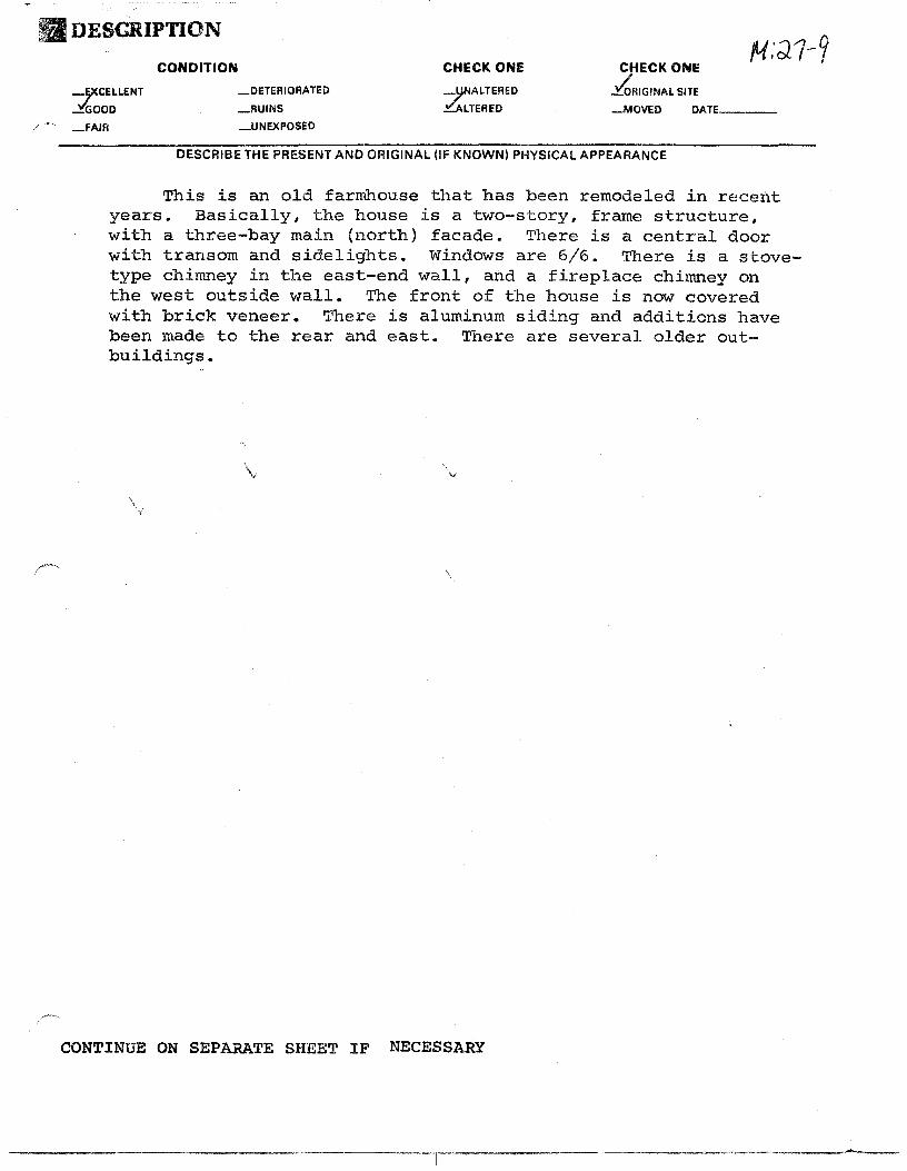
This is an old farmhouse that has been remodeled in recent years. Basically, the house is a two-story, frame structure, with a three-bay main (north) facade. There is a central door with transom and sidelights. Windows are 6/6. There is a stovetype chimney in the east-end wall, and a fireplace chimney on the west outside wall. The front of the house is now covered with brick veneer. There is aluminum siding and additions have been made to the rear and east. There are several older outbuildings.
v
CONTINUE ON SEPARATE SHEET IF NECESSARY

~l., Significance Survey No.
!.-~ri«.>d Areas of Significance-Check and Justify below ___ prehistoric __ archeology-prehistoric --·community planning __ landscape architecture __ religion -- 1400-1499 __ archeology-historic __ conservation __ law -- science -/ '""' 1500-1599
160~1699 -- 1700-1799
-.- agriculture __ economics -- literature -- sculpture ~ architecture __ education -- military -- social/ __ art __ engineering __ music humanitarian
---- 1800-1899 __ commerce __ exploration/settlement -- philosophy -- theater ---- 1900- __ communications __ industry __ politics/government -- transpo~ation
__ Invention -- other (specify)
Builder/ Architect S~'!iecific dates --------ie~i;t-f·r--ea.--~~.-.-----------------------------------check: Applicable Criteria: A B C D
and/or Applicable Exception: A B C D E F G
Level of Significance: national state local
Prepare,both a summary paragraph of significance and a gerleral stateme~t of history.and support. \
The .. Jacob VanHorn farmhouse, one of the,few remaining old homes in the Layhi.11 area, is;,;s~gnificant as an. exampl~ of vernacular architecture typical of that constructed in Montgomery County from the mid-nineteenth through the:: early _twentieth centuries. The house is believed to have been built by Henry K. :Vanhorn who,· according to the map of 1865, lived on this site in an earlier dwelling. The land consisted of approximately 220 acres of a tract of land referred to as "Layhill," and was part of the homeplace of Richard Holmes,
~ dec'eased. 2 •''
In May of 1884, Henry mortgaged the property to Beulah Thomas. He later defaulted and the property was sold in October of 1888. The notice of the sale of the property described it as a farm of approximately 205 7/8 acres located directly on the Norwood branch of the Union Turnpike to Washington and adjcdned the farms of John Bready, and George Bonifant. It was improved by a new,"commodious" frame dwelling house, a new barn and all the necessary outbuildings, and a spring of pure water 30 yards from the door. The farm was purchased by Albert Stabler.3
In January of 1900, Albert sold the 205 7/8 acre farm to George A. Willson.4 Albert had also sold 86 3/8 acres of land to Charles Parker in 1903 which was later sold to George A. Willson in 1909.5 The Willson family ran a large dairy farm here for many"years. In December of 1953, George died. As directed by his last will ancf,!=estame'nt~ the farm we11t to his wife, Sarah, and then upon her death, it was;~pas'sed to their two sons, George G. and Frank F. Willson.6 In April of 1961,~George conveyed his share of the property to Frank.7 In 1963, the house ~as remode'J;,Gi~uring which time a brick veneer was put over the original frame exterior. A Iibrary was later added in 1970.8 The house remains in the Willson family to this day as:the property of Frank Willson and his wife, Anne.
1Date given is based on the date that the land was purchased and the fact that it was described as a "new" house in 1888.
2need EBP 21/305, Mont. Co. Land Records.
see attachment sheet A

attachment sheet A ~
3Equity JA 3/389, Mor:lL Co. Judgement Records.
4need '.I'D 3 12/397, Mont. Co. Land Records.
5Deed TD 26/150, " 202/171, fl
II
" 6Wi11 WCC 47/171, Mont. Co. Register of Wills.
7need 2847/543, Mont. Co. Land Records.
8The County Courier, April 13, 1977.

g:: .. Mi;o'r'"'-iliUo·graptilca1"~References ..:>uryey No. ,t.;;m;~, ~~ -
I·'~'· i,,' I', ' ' :~
, 'Mont. Co. Land Records ~opt. Co. ~egl,.s~~r of Wills. !;191i1t •
1
Co. Equity' :! ,,_ I
~creage of n~minated propef1y 5 ' acres Quadrangle name
UTM References do NOT complete UTM references
A LLJ .LL_! __ , LLLL.-l --........ B L_ij I
Quadrangle scale
...
I I I 1.J I I I I Zone Easting Northing Zone Easting Northing
cLLJ I I I I I 1 l oLLJ LI I I I Li I eL.LlJ I I I I 1 l F LLJ I I I 1.J I I G LJ_J .) I I I L-1 ...__._ __ I ............. HLL_J I I I I I I
Verbal boundary description and justification
Ust ail states and counties for properties overlapping state or county boundaries
state code county code
state code county code
;L1. Form Prepared By name/title Catherine Crawford
organization M.C. Hist .• Preservation Cormnission date 10/82
street & number telephone .,
city or town Rockville state·· Maryland
The Maryland Historic Sites Inventory was officially created by an Act of the Maryland Legislature to be found i11 the Annotated Code of Maryland, Article 41~ Section 181 KA, 1974 supplement.
The survey and inventory are being prepared for information and record purposes only and do not constitute any i~f ringement of individual property rights.
return to: Y;aryland Historical Trust Shaw House 21 State Circle Annapolis, Maryland 21401 (301) 269-2438
I I
L.J I I
M: Q./::_J_
PS-2746

f1#27-9
MARYLAND HISTORICAL TRUST
INVENTORY FORM FOR STATE HISTORIC SITES SURVEY
DNAME HISTORIC
Jacob Van Horn Farm ANO/OR COMMON
Frank Willson Place ______ ...., .... -... ............ ---.: ...... --...;;;.;;;:.;;;.;:;;.... _______________________ ,,""""''"'"""''. fJLOCA T19N __ 'c'"' _.
STREET & NUMBER '-'.·, ·• .. c. c;.<:c;,~-~·;," '., . 14800 blo~k of ··r.'-~Yh~ii Road
:.'JH•;,., · ,:,\_CONGRESSIONALDISTR1c;f f ''<;; · (Sil~~r;"Spring P.O.-·)' · · .. /''{.
STATE ·· :•-·->Maryland·;?fC;. 1 '~"··>; 7'.1:~;_._·-_.
. COUNTY .. .."/;?\,; -'~"-;',;•Montgomery ·•-••'f' .,.
DcLAsSIFlCA TION -CATEGORY OWNERSHIP ~ATUS ~ PfU:ESE:NT USE
:talSTRICT keuc -OCCUPIED ..Y.AGRICULTURE -MUSEUM BUILDING{S) -PRIVATE -UNOCCUPIED _COMMERCIAL
_STRUCTURE _BOTl-1 _WORK IN Pl'tOORES,. _EOUCATfONAL ·kRK
~-J'l'UVATE RESIDE»C.f _SITE PUBLIC ACQUISITION ACCESSIBLE -OBJECT _IN PROCESS -YES: RESTRICTED
-BEING. CONSIDERED•, .. 7:.ES: jJNRESTRICTEO ·.
_NO
Df?WNER Of PROPERTY
STREET & NUMBER
14800 block of Layhill Road CITY.TOWN
Silver Spring _ v1c1N1TY0F
llLOCATION OF LEGAL DESCRIPTION __ COURTHOUSE. REGISTRY OF DEEDS.-ETC. Montgomery County Courthouse STREET & NUMBER
CITY. TOWN
Rockville
IJREPRESENTATION IN EXISTING SURVEYS TITLE
DATE
-ENTERTAINMENT _RELIGIOUS
_GOVERNMENT
"'7'lNOUSTRIAL
:._MILITARY
STATE r
Maryl.and
Liber t-: Folio .ft:
STATE
Maryland
_SClENTfflC
::----: 1:_RANSPORTA T[ON::. ·
_OThER:
Zl.p:: code
-FEDERAL -STATE _COUNTY _LOCAL
,cc~~ DEPOSITORY FOR
SURVEY RECORDS
CITY.TOWN STATE
iii

II DESCRIPTION
CONDITION
~CELLE NT _GOOD
_FAIR
-DETER !ORATED
-RUINS
_UNEXPOSED
CHECK ONE
-l}NALTERED
..::'.ALTERED
CHECK ONE
/o'RIGfNAL SITE
-MOVED DAT"----
DESCRIBE THE PRESENT AND ORIGINAL (IF KNOWN) PHYSICAL APPEARANCE
This is an old farmhouse that has been remodeled in recent years. Basically, the house is a two-story, frame structure, with a three-bay main (north} facade. There is a central door with transom and sidelights. Windows are 6/6. There is a stovetype ·chimney in the east-end wall, and a fireplace chimney on the west outside wall. The front of the house is now covered with brick veneer. There is aluminum siding .and addit~ons have · been made. to.the east. There:·are several olde:r:::.:.aut-
.. e=::t~~ing~.:~··=;1~~~!f,
·· ·· CONTINUE ON SEPARATE SHEET IF NECESSARY

El SIGNIFICANCE
PERIOD AREAS OF SIGNIFICANCE -- CHECK AND JUSTIFY BELOW
,- ._PAEHISTORIC -ARCHEOLOGY-PREHISTORIC -COMMUNITY PLANNING -LANDSCAPE ARCHITECTURE
_LAW -1400·1499 -ARCHEOLOGY-HISTORIC _CONSERVATION
-1500-1599 -AGRICULTURE _ECONOMICS -LITERATURE
_1600·1699
-)700-1799
Y1aoo.1a99
_1900.
-ARCHITECTURE
-ART
-COMMERCE
-COMMUNICATIONS
SPECIFIC DATES
STATEMENT OF SIGNIFICANCE
-EDUCATION _MILITARY
_ENGINEERING _MUSIC
. -EXPLORATION/SETTLEMENT _PHILOSOPHY
_INDUSTRY _POLITICS/GOVERNMENT
_INVENTION.
BUILDER/ ARCHITECT
~"<EUGION
_$0ENCE
-50..IU"TURE
--5COAUHUMANITA~IAN
-THEATER
-~TATIO~
_Ql:Hf!R ISPEOFYI
-:"i>- "'·~· '"- '
. ·.;~~~kJ.· .. Thi~;,··is one~~£{{~~;-•7f~w remaining old homes .ift an area (LayhiJ.l'H,that has- become heavily-developed in the pa.st 10 years ... ·Maps- of 186?,~ 1878, and 1~94· show the Van Horn family
. living here',. The.~present. owners I. the Willsons, are 1.ons--time residents of this area, and have owned this place for at least 30 yea.rs.
CONTINUE ON SEPARATE SHEET IF NECESSARY

0MAJOR BIBLIOGRAPHICAL REFERENCES
CONTINUE. ON SEPAR.ATE SHEET IF NECESSARY
II!]GEOGRAPHICAL DATA ACREAGE OF NOMINATED PROPERTY _______ _
_ ........... _ ... ~_ - ~./
' . ..:.\' l-s'~J .. q ...
VERBAL BOUNDARY DESCRIPTION -;"·'~<
LIST ALL STATES ANO COUNTIES FOR PROPERTIES OVERLAPPING STATE OR COUNTY BOUNDARIES
STATE COUNTY
. ,..,.. .... I, L:.~. STATE':' .M:/ -'"''''."' ":::
. C' ll!f ORM PRf;}lARED BY - - ' - - ' - - . - - --·~ -:.,"::-.. --.-' "'"' ';~0~·-~~='.~A~E I TITl:.E-'.;::~;:~z;c(:/;· :·:'::"· · . .--.:.:-.-··:·:·••:--~::·
__ :;c-:;;c,..;-.;:~s: .:.-;;~'CMichael..~F:~;; Dwyer,::~~senior.':.'.,Park Hi.storian ;,::.·.,-tf:_·ec':o ·.•···
-
ORGANIZ.A.TION DATE' '
M-NCPPC 4/22/74 STREET & NUMBER TELEPHONE
8787 Georgia Ave. 589-1480 CtTYOR TOWN STATE .
Silver Spring Maryland
The Maryland Historic Sites Inventory was officially created by an Act of the Maryland Legislature, to be found in the Annotated Code of Maryland,- Article 41, Section 181 KA, 1974 Supplement.
The Survey and Inventory are being prepared for information and record purposes only and do not constitute any infringement of individual property rights.
RETURN TO: Maryland Historical Trust The Shaw House, 21 State Circle Annapolis, Maryland 21401 (301) 267-1438
··- ·~-1
OF
)
... a: ::;r-----1 ;:
7' .92 Ac.
.... , .. , tl..17 lc..
l..U.t1LQ -•-•-*•• £LIC1't0Jlif DISTlllrCT' tO\UllOAIU"
• 111 ••••••••• CO•P'OlllA YE IQUJrijQAllU
" .. 7,. o•
~. ,,, {
ll'AJ!C[ L •O. IS US[O ,0. OWJlll[flll'Srtl~
rOflffrffC4ftOH .t.kO .wusr I( tJ•t.CCO!O IY IPllO IHF[.ili(~C( "l!.t011i1;
":._.,._ ... ~~ .~ ... ~o h•E'- ,., !.1.!
COPY;
OF OFFICE
MON
I
..
0
JR 123
HT 6Y STATE DEPARTMENT
1r DIST.
H:SSMENTS a TAXATION• 5
13 SUPERVISOR OF ASSESSMENTS
"'ERY COL•N TY, MARYL ANO I 'C?•;7 -·
I ~ µ:~l-9
.Ii M.N.C.P. B PC.
21lll5/ 52 0
279.25Ac
Ac
Bra11c . . t:::: -~·
18 87Ac.
( \ M. <. C. P. a P C
34011529
116.72 Ac.
p 60 6
J2 Cl.JRRENT TO , .. 200' SCALE 1- ,. 88
1 - 1- ea F-ca~= tt 'I I
zoo 0 200 •oo
,,_
- • , ... # •
:""\ ul.. \\'til>v' R·~~ •
- tr' \. :;:;.- ( . . d I '
---~ Gt·n1 - ·' ' k..i
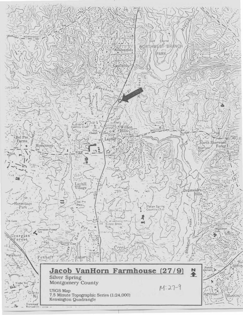
Jacob VanHorn Farmhouse (27 /9) Silver Spring Montgomery Coun ty
USGS Map 7.5 Minute Topographlc Series (1 :24.000) Kensington Quadrangle \ c""'"•, • 'I • : ,.."'
• · G-1lnm:wf .__---------------------------------• ,.. - .:\r - i;;.,., .... ,f'\ .... --- ..

V'vt '. ~I/CJ j~v~~~~ ~ Q> Mb b..., (, Siu,~ '-I~; ~ - /tl.J ~ /4.J rfJ,N;..,. c~.
~- ~.(N)~~
rv1'.? ?/°t
J~<r //~~ ~~4-
1i ~;( 4' 1t ?)
~ ~·7~~ '-f{ct1
~-~~~ ~IAA Q~. ~-~~
I


Jlh: ")-7/7 J~ v~ ~ ..... "- ~~~'e~ ~~o
~ i_,~~~ /U~ - ~:.:r U;, fk.J' {/~ ~--.
~- s elev-


;11: ;;_ 1/tt j~ll~~~~ ~Ct:,. ;uiJ ~ {,,_, ~J~ ~f<t1
JU~ . ~ 4 ~r. //~. ~. ~-s~~

//Vt', ~?/~ J ~ (/'t:J.-1~ F9~~~ ~~ ("t). Mb ~ /._, S"":l~ 'f ("f I
(V~ - fi/l~ a, I /A..ar ~"U.,, ~~I w- V"t...~ - ~~ -


In~ ~7/7 J~ lb_~~~ ~~ Co /All!> ~ L. S~~- ~(ct; fJe.s - JU~ tiJ. ~ ,~~ ~~·
5~ - /~~ Se)v7'J...


rn: ;;_ 1/9 J~~~~~ ~J-Co I~ ~ t..., s'O~ ~/cu ///ts - 11-f~~ He. ~~-~~


m;~7/9 J~~~~ ~,;r ~ lt1[>
0t /__ ~ v,,,, ~ /Ut.f)~ cD flP<t_
~~-W~

(Y): :2-? /9 . J4~ t- V"-.-~ tr9~ ~Co, M!:)
~ L S..~ '5('!1
lhs- M~. ~. H-Pr_
0,;:(h/JJ - .s~ ~


!YI,' ~ 7/~ .J ~ v(ly-~ ~ t.-~ ~~ /Jli()
/;,; L ~~ ~/et; N~-~J~~
~-s~

fh~7//9
J~~~F~~ ~~Mb ~ ~&,_.N ° t;fe;1 N'1-~~#ft_ OvY-hl~ - t ~


Ill! p~ J.,u, L~~~ /HJ G> Jltb
~ts~~ A"'J • ~4'. /,4.J~.4n-~~- Pd~.


![MySQL Installation Steps · MysQL server 5.5.24 connector,'0DBC 5.1.10 Connector/C++ 1.1.0 Connector/C 6.0.2 Connector'] 5.1.19 connector,'NET 6.4.4 MySQL Documentation 5.5.24 Samples](https://img.pdfslide.net/doc/110x75/5fdb66d66432103e17178378/mysql-installation-steps-mysql-server-5524-connector0dbc-5110-connectorc.jpg)


![Medi-Cal Handbook Intercounty Transfer (ICT) 15 ...Intercounty Transfer (ICT) 15. Intercounty Transfer (ICT) 15.1 General Requirements [50136-50138, 50185] An Intercounty Transfer](https://img.pdfslide.net/doc/110x75/5f26078611cd1310f24a122e/medi-cal-handbook-intercounty-transfer-ict-15-intercounty-transfer-ict-15.jpg)