Embed Size (px)
Citation preview
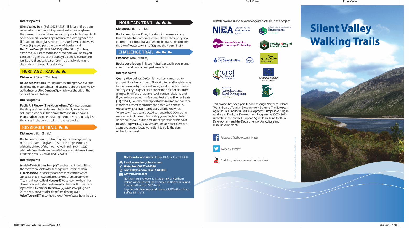
This project has been part-funded through Northern Ireland Tourist Board’s Tourism Development Scheme. The European Agricultural Fund for Rural Development: Europe investing in rural areas. The Rural Development Programme 2007 - 2013 is part financed by the European Agricultural Fund for Rural Development and the Department of Agriculture and Rural Development.
NI Water would like to acknowledge its partners in this project.
Silent Valley Walking TrailsMourne Mountains
Landscape Partnership
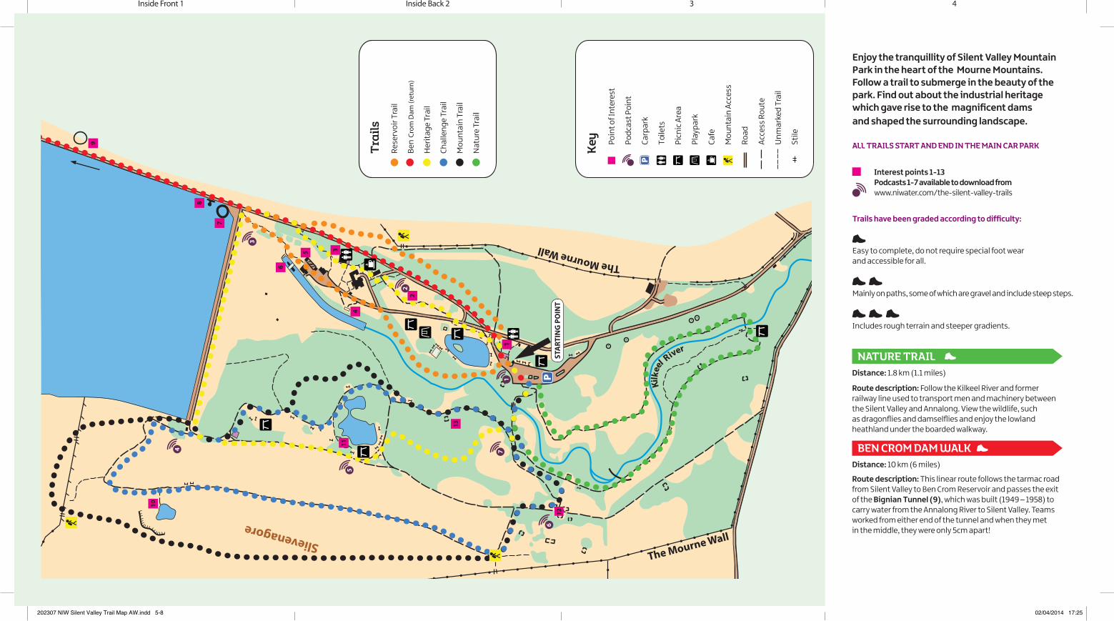
Interest points
Silent Valley Dam (Built 1923-1933). This earth filled dam required a cut off trench to prevent water seeping below the dam and moving it. A core wall of “puddle clay” was built and the embankment slopes completed with “graded rock fill”, soil and then grass. Notice the Overflow (7) and Valve Tower (8) as you pass the corner of the dam wall.Ben Crom Dam (Built 1954-1957). After 5 km (3 miles), climb the 260 steps to the top of the dam wall where you can catch a glimpse of the Brandy Pad and Slieve Donard. Unlike the Silent Valley, Ben Crom is a gravity dam as it depends on its weight for stability.
HERITAGE TRAIL Distance: 2.8 km (1.75 miles)
Route description: Circular route including views over the dam into the mountains. Find out more about Silent Valley at the Interpretive Centre (3), which was the site of the original Police Station.
Interest points
Public Art Piece – “The Mourne Hand” (1) incorporates the story of stone, water and the resilient, skilled men of Mourne who built the dam with “hands like shovels”.Memorial (2) Commemorating the men who tragically losttheir lives in the construction of the reservoirs.
RESERVOIR TRAILDistance: 1.6km (1 mile)
Route description: This trail highlights the engineering hub of the dam and gives a taste of the high Mournes with a backdrop of the Mourne Wall (Built 1904– 1922) which defines the boundary of NI Water’s catchment area, stretching over 22 miles and 17 peaks.
Interest points
Model of ‘cut off trenches’ (4) Trenches had to be built into the earth to prevent water seepage from under the dam. Filter Plant (5) This facility was used to screen raw water, a process that is now carried out by the Drumaroad Water Treatment Works. Boat House (6) Water overflow from the dam is directed under the dam wall to the Boat House where it joins the Kilkeel River. Overflow (7) A massive plug hole, 25 m deep, prevents the dam from flowing over. Valve Tower (8) This controls the out flow of water from the dam.
Facebook: facebook.com/niwater
YouTube: youtube.com/northernirelandwater
Twitter: @niwnews
MOUNTAIN TRAILDistance: 3.4km (2 miles)
Route description: Enjoy the stunning scenery along this trail which incorporates steep climbs through typical Mourne upland habitat and woodland trails. Look out for the site of Watertown Site (12) and the Pugmill (13).
CHALLENGE TRAIL Distance: 3km (1.9 miles)
Route description: This scenic trail passes through somesteep upland habitat and park woodland.
Interest points
Quarry Viewpoint (10) Cornish workers came here to prospect for silver and lead. Their singing and laughter may be the reason why the Silent Valley was formerly known as ‘Happy Valley’. A great place to see the heather bloom or glimpse birdlife such as ravens, wheatears, skylarks and if you’re lucky, peregrine falcons. Rest at the Shelter Seats (11) by Sally Lough which replicate those used by the stone cutters to protect them from the bitter wind and rain.Watertown Site (12) A temporary village known as ‘Watertown’ was constructed to house the 2000 strong workforce. At its peak it had a shop, cinema, hospital and dance hall as well as the first street lights in the island of Ireland. Pugmill (13) Clay was ground up here to remove stones to ensure it was watertight to build the dam embankment wall.
Front CoverBack Cover65
Northern Ireland Water PO Box 1026, Belfast, BT1 9DJ
Email: [email protected] Waterline: 08457 440088 Text Relay Service: 08457 440088 www.niwater.com
Northern Ireland Water is a trademark of Northern Ireland Water Limited, incorporated in Northern Ireland, Registered Number NI054463.Registered Office: Westland House, Old Westland Road, Belfast, BT14 6TE
Fron
t cov
er im
age
cour
tesy
of D
avid
Kir
kwoo
d
202307 NIW Silent Valley Trail Map AW.indd 1-4 02/04/2014 17:25
OO
Kilk
ee
l River
Slievenagore
The Mourne Wall
The Mourne Wall
1
2
35
6
7
8
4
10
11
12
13
PST
ART
ING
PO
INT
1
2
3
4
5
6
7
9
NATURE TRAIL Distance: 1.8 km (1.1 miles)
Route description: Follow the Kilkeel River and former railway line used to transport men and machinery between the Silent Valley and Annalong. View the wildlife, such as dragonflies and damselflies and enjoy the lowland heathland under the boarded walkway.
BEN CROM DAM WALK Distance: 10 km (6 miles)
Route description: This linear route follows the tarmac road from Silent Valley to Ben Crom Reservoir and passes the exit of the Bignian Tunnel (9), which was built (1949 – 1958) to carry water from the Annalong River to Silent Valley. Teams worked from either end of the tunnel and when they met in the middle, they were only 5cm apart!
Enjoy the tranquillity of Silent Valley Mountain Park in the heart of the Mourne Mountains. Follow a trail to submerge in the beauty of the park. Find out about the industrial heritage which gave rise to the magnificent dams and shaped the surrounding landscape.
ALL TRAILS START AND END IN THE MAIN CAR PARK
Trails have been graded according to difficulty:
Easy to complete, do not require special foot wear and accessible for all.
Mainly on paths, some of which are gravel and include steep steps.
Includes rough terrain and steeper gradients.
Interest points 1-13 Podcasts 1-7 available to download from www.niwater.com/the-silent-valley-trails
4Inside Back 2 3Inside Front 1
202307 NIW Silent Valley Trail Map AW.indd 5-8 02/04/2014 17:25