Embed Size (px)
Citation preview
Interim Advice Note 135/10 (W) Landscape and Visual Effects Assessment
IAN 135/10 (W) Page 1 of 54 Apr 14
INTERIM ADVICE NOTE 135/10 (W) LANDSCAPE AND VISUAL EFFECTS ASSESSMENT
WALES ONLY
Summary This Interim Advice Note provides instructions on the assessment of landscape and visual effects of highway projects. Instructions for use
This IAN takes immediate effect and is applicable to the reporting of environmental impact assessments of trunk road and motorway projects in Wales replacing existing guidance in DMRB Volume 11 Section 3 Part 5.

Interim Advice Note 135/10 (W) Landscape and Visual Effects Assessment
IAN 135/10 (W) Page 2 of 54 Apr 14
Executive summary
This Interim Advice Note (IAN) sets out the requirements for the Welsh Government and Managing Agents; and their service providers for the assessment and reporting of the effects highway projects have on landscape character and on views from sensitive visual receptors. It has application to new construction, improvement and maintenance projects. It has been prepared in accordance with the principles set out in DMRB Volume 11 Section 2 providing a methodology for considering the significance of identified effects. The IAN replaces DMRB Volume 11 Section 3 Part 5 for use in Wales.

Interim Advice Note 135/10 (W) Landscape and Visual Effects Assessment
IAN 135/10 (W) Page 3 of 54 Apr 14
Landscape and Visual Effects Assessment
Table of Contents EXECUTIVE SUMMARY 1. INTRODUCTION
Structure of Advice Note Scope of Advice Note Implementation Equality Impact Assessment Risk Assessment The Intended Audience for the Advice Note Feedback
2. LANDSCAPE AND UK HIGHWAYS Definition of Subject Regulatory/Policy Framework Key Issues/Impacts/Effects Overlaps and Interactions with Other Subjects Project Objectives
3. ASSESSMENT PROCESS
Overview of Process Value/Sensitivity of Resource Baseline Studies Magnitude and Types of Impacts Significance of Effect Uncertainty and Validity
4. DESIGN AND MITIGATION 5. MANAGEMENT OF ENVIRONMENTAL EFFECTS 6. MONITORING AND EVALUATION 7. REPORTING
Scoping Simple Detailed
8. ENQUIRIES ANNEX 1 ASSESSMENT OF LANDSCAPE EFFECTS ANNEX 2 ASSESSMENT OF VISUAL EFFECTS ANNEX 3 GLOSSARY ANNEX 4 REFERENCES

Interim Advice Note 135/10 (W) Landscape and Visual Effects Assessment
IAN 135/10 (W) Page 4 of 54 Apr 14
1 Introduction
Structure of Advice Note
1.1 The general principles are set out in the following chapters. Details relevant to the specific assessment of landscape and visual effects are covered in annexes 1 and 2 respectively. Definitions of terms are provided in annex 3.
Scope of Advice Note
1.2 This Advice Note gives guidance on the assessment of the landscape (a generic term which includes ‘townscape’ or urban areas) and visual effects that may result from a road project. It expands on the advice set out in Volume 11 Sections 1 and 2 which should be read in conjunction with this advice.
Implementation
1.3 This IAN must be used forthwith on all projects for the assessment of all motorway and all purpose trunk roads except where the procurement of works has reached a stage at which, in the opinion of the Welsh Government, its use would result in significant additional expense or delay progress (in which case the decision must be recorded) Equality Impact Assessment
1.4 This IAN promotes consistency in highway work for Welsh Government in the approach to landscape assessment. Any adverse or beneficial effects that arise from the introduction of this guidance are not expected to discriminate against any defined group in society. Therefore a social equality impact assessment is not considered necessary.
Risk Assessment
1.5 This IAN promotes consistency of Welsh Government internal procedures and provides guidance to ensure legislation is complied with. Any adverse or beneficial impacts that result from the introduction and adoption of this guidance are not expected to result in implications for health and safety. No risk assessment has been carried out in the development of this Advice Note as it is not considered relevant. The Intended Audience for the Advice Note
1.6 This Advice Note is intended for use by suitably qualified professionals carrying out landscape and visual impact assessments of Welsh trunk road projects, including new construction, improvement and maintenance projects. It should also be used for reference by Project Managers, Environmental Co-ordinators, Design Organisations, Agents and Contractors when dealing with the Overseeing Organisation’s environmental assessments.
Feedback
1.7 Contact information is at the end of the document, to help improve the performance of IANs.
Interim Advice Note 135/10 (W) Landscape and Visual Effects Assessment
IAN 135/10 (W) Page 5 of 54 Apr 14
2 Landscape and UK Highways
Definition of Subject
2.1 The European Landscape Convention (Florence: Council of Europe, 2000, ETS 176), defines ‘Landscape’ as ‘an area, as perceived by people, whose character is the result of the action and interaction of natural and/or human factors’. Landscape is therefore perceived by past, present and future as well as natural and cultural influences. Future landscapes will continue to be influenced by changes in climate, agriculture, development needs, and by progress towards a low carbon society.
2.2 The Guidelines for Landscape and Visual Impact Assessment (GLVIA), published jointly by The Landscape Institute and the Institute of Environmental Management and Assessment (3rd edn. 2013) embraces this broad interpretation of what landscape means and further emphasises the importance of the European Landscape Convention (ELC) definition in that ‘it encourages a focus on landscape as a resource in its own right. It also provides an integrated way of conceptualising our surroundings and is increasingly considered to provide a useful spatial framework for thinking about a wide range of environmental, land use and development issues’ (GLVIA para 2.4). GLVIA further states that ‘the definition of landscape applies to all types of rural landscapes of villages, towns and cities’ (GLVIA para 2.5). Therefore
this guidance adopts the approach that applies to any landscape whether the context is urban, rural or a combination of both.
2.3 Regarding the subject of sustainable development, the GLVIA states that ‘It is broadly
agreed that it involves finding an appropriate balance between economic, social and environmental matters, and that protecting and enhancing the natural, built and historic environment is an important part of this’ (GLVIA para 2.14). Furthermore, ‘as a technical process LVIA has an important contribution to make to the achievement of sustainable development. It takes place in a context where, over time, landscapes evolve and society’s needs and individual and community attitudes change’ (GLVIA para 2.15). It should also be noted that there are a constitutional set of principles in
Wales on the need for the Welsh Government to promote sustainable development. 2.4 The assessment of landscape and visual effects must address both effects on
landscape as a resource in its own right as well as effects on views and visual amenity. These related but very different considerations of an LVIA are described in the GLVIA as follows:
Assessment of landscape effects: assessing effects on the landscape as a resource in its own right;
Assessment of visual effects: assessing effects on specific views and on the general visual amenity experienced by people.
Landscape resource is further described as ‘resulting from the interplay of the physical, natural and cultural components of our surroundings. Different combinations of these elements and their spatial distribution create the distinctive character of landscapes in different places, allowing different landscapes to be mapped, analysed and described. Character is not just about the physical elements and features that make up a landscape, but also embraces the aesthetic, perceptual experiential aspects of the landscape that make different places distinctive’ (GLVIA para 2.19), whilst visual effects are described as ‘the views that people have and their visual amenity – meaning the overall pleasantness of the views they enjoy of their surroundings’ (GLVIA para 2.19).
Interim Advice Note 135/10 (W) Landscape and Visual Effects Assessment
IAN 135/10 (W) Page 6 of 54 Apr 14
Regulatory/Policy Framework
2.5 In 2000, the European Landscape Convention was produced by the Council of Europe, the aims of which are ‘to promote landscape protection, management and planning, and to organise European co-operation on landscape issues’. This was the first international convention to focus specifically on landscape. The Convention was signed by the UK government on 24 February 2006 and ratified by the Council of Europe on the 21 November 2006. It is significant in that it acknowledges ‘that the landscape is an important part of the quality of life for people everywhere: in urban areas and in the countryside, in degraded areas as well as in areas of high quality, in areas recognised as being of outstanding beauty as well as everyday areas’. The recognition that all landscapes are potentially important, irrespective of location or condition, should be considered in any assessment of landscape effects and is acknowledged within this Advice Note.
2.6 The statutory organisation that provides advice on landscape issues in Wales is Natural Resources Wales (formerly the Countryside Council for Wales, Environment Agency Wales and the Forestry Commission Wales). This organisation offers policy and advice on landscape, and is the primary source of definitive information and opinion on statutorily protected landscape areas in Wales. For cross border projects, the statutory organisations in England are Natural England and the Environment Agency.
2.7 Many parts of Wales are included in national, local, statutory and non statutory
landscape designations. In particular, nationally important landscapes such as National Parks and Areas of Outstanding Natural Beauty (AONB’s) are protected by statutory legislation in the form of Acts. These are further recognised by the International Union for Conservation of Nature (IUCN) as Category V protected areas: as places where people live and work, and for their high biodiversity value. Other non-statutory landscapes of importance in Wales include; Heritage Coasts, Landscapes of Historic Interest and World Heritage Sites.
2.8 Local planning authorities (and National Park Authorities where appropriate) also
designate landscapes in development plans and hold information on regional and locally important landscapes to which policies apply. The Local Authority should be consulted at an early stage to gain information about the local landscape.
Key Issues/Impacts/Effects 2.9 For landscape and visual effects, the key issues are likely to be:
Whether the effects are temporary (e.g. the impact of a construction compound) or permanent (e.g. the removal of existing features or creation of new infrastructure);
Short or long term effects;
direct effects or physical change to the landscape (e. g. landform changes, vegetation changes, changes to built features);
indirect effects on the character and quality of the landscape (e.g. changes in the perception of the landscape through the introduction of features alien to the character of the landscape;
direct effects on the visual amenity of visual receptors (e.g. changes in views and their composition for walkers, tourists etc. caused by the project);
indirect effects on visual receptors in different places (e.g. an altered visual perception leading to changes in public attitude, behaviour and how they value or use a place).
Interim Advice Note 135/10 (W) Landscape and Visual Effects Assessment
IAN 135/10 (W) Page 7 of 54 Apr 14
How the project would relate in landscape and visual terms to any other proposed development (e.g. urban regeneration schemes, housing development etc.).
Cumulative effects resulting from multiple actions on receptors over time (e.g. cumulative impacts from a single project (impacts from combined action of a number of different environmental topic specific impacts) and cumulative impacts from different projects (in combination with the project being assessed).
Overlaps and Interactions with Other Subjects 2.10 Some other topics within an environmental assessment may touch on landscape
issues or use landscape data, and care must be taken to avoid ‘double counting’ in the assessment process. This will require liaison between the various specialists at an early stage in order to eliminate overlaps, identify gaps, remove confusion and ensure effective and integrated mitigation proposals. Environmental Management Plans (EMPs) are considered as an important process tool for managing the different topic area effects.
2.11 This is particularly relevant for the Historic Landscape sub-topic of the Cultural
Heritage advice note (see Volume 11 SECTION 3 Part 2), where the combination of historic landscape evidence and the potential change in the setting of, or views from historic monuments are clearly related (see ‘Guide to good practice on using the register of landscapes of historic interest in Wales in the planning and development process’, CADW, 2nd edition 2007 and ‘Assessing the Effect of Road Schemes on Historic Landscape Character’, Highways Agency, 2007).
2.12 Another area of potential overlap is with Nature Conservation (see Volume 11
SECTION 3 Part 4), since landscape provides the context for habitats and species, and the potential loss of landscape features and/or land severance/fragmentation will also affect biodiversity. Social and community issues (see Volume 11 SECTION 3 Part 8) may also overlap with the landscape topic (i.e. the way that spaces are used and valued by the local community).
2.13 It is also important to be aware of project mitigation proposals that may involve other
topic areas, such as the installation of noise screening that would also have visual implications. Conversely, landscape requirements, such as screen planting, may, for example, disturb archaeological remains or conflict with wildlife considerations.
Project Objectives
2.14 At an international level the European Landscape Convention sets high level objectives which are reflected at the national level in the Government’s statutes and planning guidance.
2.15 The scheme specific project objectives should therefore take account of priorities set
out by the Overseeing Organisation and statutory organisations, including where applicable any high level Objectives (eg: those arising from Strategic Environmental Assessment (SEA) which is undertaken for plans and programmes; and relevant Transport Planning Objectives). Local authority (and, where relevant, National Park) plans and initiatives may also contain relevant priorities for local objectives.
2.16 Objectives should inform the early stages of project definition (i.e. the consideration of
route and/or design options). The project level objectives are then used to assess the scheme against through the assessment of any alternatives and the scheme design.

Interim Advice Note 135/10 (W) Landscape and Visual Effects Assessment
IAN 135/10 (W) Page 8 of 54 Apr 14
The landscape aspects should be used at the appraisal stage through to the final design ensuring full integration in the whole design process.
Interim Advice Note 135/10 (W) Landscape and Visual Effects Assessment
IAN 135/10 (W) Page 9 of 54 Apr 14
3 Assessment Process
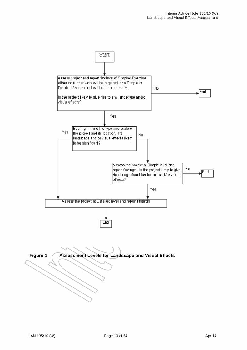
Overview of Process 3.1 The flow chart at figure 1 summarises the links and differences between the use of
Scoping, Simple and Detailed Assessments. It is important to recognise that the process is consequential rather than sequential (i.e. further detailed work will not automatically follow if the assessment shows that significant effects are unlikely). The assessment levels are outlined as follows;
Scoping
3.2 The Scoping Exercise should determine whether or not the project is likely to give rise to any landscape or visual effects. It is important to consider the location and context of the project in this respect; for example, projects to maintain or renew existing structures, minor realignment projects, or lighting schemes in well lit urban areas may not give rise to any additional landscape or visual effects. The output of the Scoping Exercise will be a recommendation for no further work, or for a Simple or Detailed Assessment as appropriate.
Simple 3.3 A Simple Assessment should be used when it is considered unlikely that the project
would have any significant landscape and/or visual effects. 3.4 For landscape effects this situation may occur;
when the landscape resource is in a poor or degraded condition.
when impacts are temporary or minor in scale (e.g. the addition of new signage to an existing signed road, managed motorway schemes, minor improvements such as the introduction of a local junction or roundabout).
3.5 For visual effects this situation may occur;
where there are no sensitive receptors (e.g. a project in a commercial or industrial area)
where there are no nearby receptors (e.g. residential properties some distance away)
Detailed
3.6 A Detailed Assessment should be used when significant landscape and/or visual effects are anticipated.
3.7 For landscape effects this situation may occur;
when the landscape resource is of distinctive quality with a range of landscape elements in good condition.
when impacts are significant in terms of duration and scale (e.g. major new road improvements, road widening projects; major lighting schemes).
3.8 For visual effects this situation may occur;
where there are sensitive receptors in the immediate vicinity (e.g. a recreational path or residential properties)
where there are large numbers of sensitive receptors (e.g. a residential suburb which overlooks the project).
Interim Advice Note 135/10 (W) Landscape and Visual Effects Assessment
IAN 135/10 (W) Page 10 of 54 Apr 14
Figure 1 Assessment Levels for Landscape and Visual Effects

Interim Advice Note 135/10 (W) Landscape and Visual Effects Assessment
IAN 135/10 (W) Page 11 of 54 Apr 14
Value/Sensitivity of Resource
3.9 The baseline resource is assessed to form the basis for the identification and description of the changes. For the landscape baseline, ‘the aim is to provide an understanding of the landscape in terms of its constituent elements, its character and the way this varies spatially, its geographic extent, its history, its condition, the way the landscape is experienced, and the value attached to it’ (GLVIA para 3.15).
Landscape Character studies form an important aspect of the assessment and this is comprehensively covered in ‘Landscape Character Assessment Guidance for England and Scotland’ (LCA), published in 2002 by the former Countryside Agency and Scottish Natural Heritage (SNH). This provides ‘an appropriate way to look at landscape because it provides a structured approach to identifying character and distinctiveness as well as value’ (LCA para 1.12). Further guidance on landscape
character types specific to Wales is provided in two design guides produced by the Welsh Government, Roads in Lowland Areas’, 1993 and ‘Roads in Upland Areas’, 1990 as well as National Resources Wales Guidance notes on LANDMAP such as guidance note 3 – ‘Landscape and Visual Impact Assessment for onshore windfarms’, 2008 and guidance note 4 – ‘LANDMAP and the Cultural Landscape’, 2013.
3.10 As part of the landscape baseline description, the sensitivity of the landscape should
be established by combining judgments of the landscape receptors susceptibility to the type of change proposed and the value attached to the landscape. The baseline studies for visual assessment are determined from the extent of the area in which the development may be visible, the different groups of people who may experience views of the development, the places where they will be affected and the nature of the views and visual amenity at those points.
3.11 The sensitivity of visual receptors can reasonably be assumed in advance of any
potential change as part of the baseline studies. The visual sensitivity should be assessed in terms of ‘the susceptibility of the receptor to the type of change arising from the specific proposal in terms of views and visual amenity; and also the value attached to the particular views by the receptor’ (GLVIA para 3.26.) Baseline Studies
3.12 A baseline situation is established by a combination of desk study, consultation and field survey. The purpose of the baseline study is to understand the landscape and visual context upon which the proposed project may have an effect.
3.13 The baseline landscape and visual context is the ‘Do-Minimum’ scenario and is
defined as that which exists immediately prior to the start of construction of the proposed project (including existing roads and other infrastructure elements), together with any known or likely changes (other consented development proposals for instance) which will take place before the projected completion of the project.
3.14 A study area must be established at the outset of the assessment. This will cover the
area to be assessed, and should contain all of the likely significant effects of the proposal on any component of the landscape and visual resource. This is likely in most cases to extend beyond the physical limits of the project, but should be limited to what is necessary to assess the potential significance of the effects of the project.
3.15 Consultation may be carried out at an early stage in the assessment process to
supplement data collection by identifying past and present perceptions of special interest or value. Consultation with a wide range of stakeholders may be appropriate (e.g. statutory environmental bodies, local authorities, local residents and other interest groups; and the relevant managing agent). Consultation should be limited to

Interim Advice Note 135/10 (W) Landscape and Visual Effects Assessment
IAN 135/10 (W) Page 12 of 54 Apr 14
what is appropriate for the size and complexity of the project and the level of assessment. A list of consultees should be agreed with the Overseeing Organisation.
Landscape Baseline 3.16 Landscape Character Assessment is essentially a two stage process involving the
value-free process of characterisation and the subsequent making of judgements based on knowledge of landscape character (see LCA figure 2.4 and box 2.2). One of the outputs of this process is to determine the value of the landscape, both of character areas and individual features and elements.
3.17 The national landscape assessment tool available as a resource in Wales is the
LandMAP landscape information system, published by Natural Resources Wales. This is formally recognised in Planning Policy Wales (PPW) (2012) as the starting point for landscape assessments in Wales. LandMAP is an all-Wales GIS based landscape resource comprised of five evaluated aspects known as geological landscape, landscape habitats, visual and sensory, historic landscape and cultural landscape. This existing tool is currently available on the CCW / NRW website and can therefore aid in the evaluation of the value and sensitivity of the affected landscape, as each aspect is evaluated in terms of its value at community, local, national and international level.
3.18 The initial stages in the baseline gathering process should make use of the available
information on LandMAP, available landscape character assessments from local
authorities and also the Landscape Character Map for Wales produced by National Resources Wales. As required, a site based assessment will also be undertaken to complete the assessment process and check the applicability of the assessment throughout the study area and refine it where necessary. The landscape character assessment will involve a factual description of the components that make up the landscape (landform, vegetation, landuse etc.), together with a description of more experiential elements such as scale, pattern, tranquillity, wildness etc. The condition (i.e. quality) of the elements which make up the landscape should also be assessed. The result of this part of the process is the identification of areas of landscape character, with value free descriptions and identification of the key characteristics that are important in creating the character of each area.
3.19 The final stages in the process involve making judgements about landscape character
that will inform particular decisions, which in the case of UK trunk roads are related to the importance or value attached to the landscape. These judgements are guided by known facts, such as local or national designations, historic and cultural aspects, local opinion, importance to the local community etc. (eg: Gwent Levels for ecological value or Tintern/Wye Valley for links with cultural poets). Historical and cultural assets of significance, as well as those of local significance (which are not currently designated) should also be considered as part of the landscape character evaluation process. Assets of local significance may for example be valued by local communities for their contribution to local distinctiveness and their sense of identity. Visual Baseline
3.20 A baseline situation for visual studies is determined through gaining an understanding of the visual amenity of the area, which will be informed by the Landscape Character Assessment, and the potential extent of visibility of the project. This will involve mapping the ‘Zone of Theoretical Visibility’ (ZTV), which is defined as a ‘map showing areas of land within which a development is theoretically visible’ (GLVIA, Glossary).
Interim Advice Note 135/10 (W) Landscape and Visual Effects Assessment
IAN 135/10 (W) Page 13 of 54 Apr 14
3.21 The baseline will also require the identification of visual receptors and their sensitivity to change relating to the proposed development, including defining the extent and quality of their existing views. Magnitude and Types of Impacts
3.22 The magnitude of impact is the degree of change that would arise if the project were to be completed (i.e. ‘Do Something’), as compared with a ‘Do Minimum’ situation. Factors to consider are the scale of the impact (e.g. would the change be large and widespread or small and localised?), the nature of the impact (e.g. would the change contrast markedly with the receiving landscape or blend in?), whether it is an adverse or beneficial change, and the timescale involved (i.e. of short duration or longer term).
3.23 In assessing the potential impact of a project, all elements of the work should be
considered and whether the impact would be temporary or permanent, direct or indirect, or cumulative. For example, the impacts of access arrangements and the disposal of excess material should be considered as well as the impact of the completed structure. Similarly, the impact of any ancillary items such as signs, gantries, noise barriers, CCTV masts and lighting should also be considered.
3.24 In addition to the fixed infrastructure, the impacts of predicted traffic movement should
be considered. In some cases movement of traffic could be more visible and create a greater impact than the presence of the road itself (e.g. an at-grade, unlit road in a flat landscape may not be widely visible, but the traffic passing along it could be). Conversely, a reduction in traffic consequent upon the project (for example within a town which has been bypassed) should also be considered. There may also be impacts resulting from the scheme due to altered traffic flows beyond the immediate project boundaries, and any significant visual change would need to be considered.
3.25 The impact of temporary works to facilitate construction (e.g. site compounds, access
roads, borrow pits and storage areas) should also be considered, although these may be subject to planning controls rather than highways procedures. If the location of these facilities is not known at the time of the assessment, then sensitive areas may need to be identified in order to inform construction contractors. Significance of Effect
3.26 For landscape effects, the assessment of their significance is determined by considering the nature of the receptor likely to be affected (sensitivity) and the nature of the effect likely to occur (magnitude of impact), arising from the project on each of the features (see GLVIA figure 3.5 for an example of the step by step process for assessing significance).
3.27 For visual effects, the assessment of their significance is determined by considering
the sensitivity of the receptor to the magnitude of the change in visual amenity arising from the project.
3.28 In determining the overall significance of landscape and visual effects, the separate
judgements about the sensitivity of the landscape receptors and the magnitude of the landscape effects need to be combined to allow a final judgement of significance. Assessing against agreed criteria:
Sensitivity
The susceptibility of the receptor to the type of change arising from the specific proposal; and
The value attached to the receptor.
Interim Advice Note 135/10 (W) Landscape and Visual Effects Assessment
IAN 135/10 (W) Page 14 of 54 Apr 14
Magnitude of Impact
The size and scale of the effect;
The geographical extent of the area affected; and
The duration of the effect and its reversibility.
Consideration of all these criteria should feed into a comprehensive assessment of significance.
3.29 In general, more significance is likely to be placed on large long term or permanent
changes than small short term temporary ones
3.30 In Wales, the assignment of significance before the consideration of the effectiveness of the design and committed mitigation measures should also be undertaken, allowing for the case or reason for and the effectiveness of mitigation to be described (HA 205/08 para 2.9). Uncertainty and Validity
3.31 Whilst some aspects of the landscape and visual assessment process are relatively objective (e.g. character analysis) many aspects require professional judgement (e.g. determining landscape quality). In addition, it may be difficult to achieve a consensus regarding value, since different interest groups will perceive the landscape in different ways. It is therefore important that the assessment is as transparent as possible, clearly stating the reasons for making certain judgements and noting any differences of opinion between different interest groups.
Interim Advice Note 135/10 (W) Landscape and Visual Effects Assessment
IAN 135/10 (W) Page 15 of 54 Apr 14
4 Design and Mitigation
4.1 Mitigation should be addressed as an intrinsic part of the assessment process, amending the design wherever possible to avoid or reduce landscape and/or visual impacts as part of an iterative process (see HA 201/08 para 2.3-2.6 for further information on this process). Mitigation must be justified as ‘essential’ to the scheme under the Highways Act. Where appropriate however, mitigation should include consideration and integration of the wider environmental benefits in the design process. Examples of benefits could include contributions to green infrastructure, climate change adaptation and ecosystem principles.
4.2 Sympathetic treatment of parts of the project can, in some circumstances, help the
integration of a new development into the surrounding landscape, but measures that are simply added on to a ‘fixed design’ as ‘cosmetic’ landscape works, such as screen planting, barriers or earth shaping designed to reduce the negative affects are the least desirable. In terms of effectiveness of integration therefore, the mitigation hierarchy should always be to firstly ‘prevent’ (avoid), then, if this cannot be achieved, to ‘reduce’, and finally to ‘replace’ (or remedy).
4.2 Any mitigation which cannot be guaranteed at the time of assessment (such as off
site planting by agreement) should not be included in the assessment, but the possible additional effects of such mitigation should be noted separately.
4.3 However, where mitigation works are deemed essential it is imperative that these can
be delivered; the landscape professional must work closely with the engineering designer and other consultants, to ensure that the mitigation measures are deliverable and achievable within the constraints of programme, cost, and other project objectives.
4.4 Delivery of mitigation measures and agreed enhancement proposals can be dealt
with through an Environmental Management Plan (EMP). The EMP is a tool for managing the effects of the project during construction and beyond, and the use of a Plan is considered important for ensuring good delivery of the landscape proposals throughout the whole process.

Interim Advice Note 135/10 (W) Landscape and Visual Effects Assessment
IAN 135/10 (W) Page 16 of 54 Apr 14
5 Management of Environmental Effects
5.1 It is important that any commitments made (e.g. before and within an Environmental
Statement or at a public inquiry) regarding the landscape design or mitigation are recorded and checked against the project requirements and objectives as construction proceeds. Where appropriate, this can be incorporated in the Construction Environmental Management Plan (CEMP) and the Plan used to make managing agents aware of any such issues which need to be dealt with during operation.

Interim Advice Note 135/10 (W) Landscape and Visual Effects Assessment
IAN 135/10 (W) Page 17 of 54 Apr 14
6 Monitoring and Evaluation
6.1 Following completion, the project should be monitored to ensure that mitigation
measures are maintained and managed to achieve the project objectives and fulfil any commitments made. It may be appropriate to record outstanding issues from monitoring in the Environmental Management Plan which is handed over to the managing agents.
Interim Advice Note 135/10 (W) Landscape and Visual Effects Assessment
IAN 135/10 (W) Page 18 of 54 Apr 14
7 Reporting of Assessments
7.1 Volume 11 Section 2 provides general advice on the relationship between Scoping,
Simple and Detailed assessments and their reporting. The following paragraphs provide an indication of the level of information that should be provided for landscape and visual effects at each assessment level. The differences in outputs for Scoping, Simple and Detailed Assessments are discussed in more detail in Annexes 1 and 2. Scoping
7.2 The Scoping Exercise must be focussed on informing the decision making process. No work should be carried out which does not directly assist the decision about whether further work is necessary, and if it is, what the appropriate level of assessment required for the next stage of the project should be.
7.3 Information necessary at this stage includes the following, at a level of detail
appropriate to a preliminary appreciation:
the nature, extent and scale of the proposed project;
areas of designated landscape importance or value;
location of important visual receptors;
national, regional or local landscape character areas already identified by others; and
the location and nature of settlements (including planned settlements or other significant planned development), Public Rights of Way and roads/railways.
7.4 The report should include an Ordnance Survey (OS) based key plan at an
appropriate scale showing the locations of landscape designations, important visual receptors and scheme options if known.
Simple
7.5 A Simple level of assessment should be a brief assessment based on the assembly of relevant data and information beyond that which is readily available (see HA 201/08 for full details on level of detail required). The Simple assessment adds
further appropriate detail to that of the Scoping exercise gained through investigation of relevant data sources, field surveys and consultation.
7.6 The report should consist of an introduction outlining the scheme context and
background, followed by a section outlining the assessment methodology (i.e. methods to be adopted for data collection, baseline evaluation, the assessment of magnitude of impacts and significance of effects). A section should also be provided outlining the implications for the scheme of relevant legislation and summarising the results of any consultation.
7.7 The report should be divided between landscape and visual effects with distinct
sections covering baseline, magnitude of impact and significance of effect. 7.8 The report should be illustrated with figures to show on an OS based map any
designated areas, landscape constraints and principal features. Key viewpoints and villages or larger centres of population which may experience potential visual effects should also be shown. The proposed project should be illustrated highlighting those elements (where known) which would result in changes to the landscape, such as cuttings, embankments, junctions and the alignment of any new roads and lighting, gantries, signs and other highways infrastructure.
Interim Advice Note 135/10 (W) Landscape and Visual Effects Assessment
IAN 135/10 (W) Page 19 of 54 Apr 14
Detailed
7.9 A Detailed Assessment is required where there is the potential for significant landscape and visual effects. The studies will require detailed desk and fieldwork to identify the character of the landscape, including its condition and value, and the nature and sensitivity of the visual receptors that may be affected by the project.
7.10 The project will need to have been designed in sufficient detail to enable potential
impacts to be determined. The sensitivity of the landscape (and of the individual elements and features that define character) must be assessed as to the degree that the proposed changes could be accommodated without altering landscape character. Any mitigation to avoid, reduce or remedy the changes should be taken into consideration in determining the significance of the resultant effects.
7.11 The report should provide the introductory sections as outlined for the Simple
Assessment in paragraph 7.6, extended where necessary to explain any additional evaluation methodologies undertaken for the Detailed Assessment. Distinct sections covering landscape and visual effects should be provided.
7.12 The proposed project should be illustrated using plans which highlight those aspects which would result in changes to landscape character and visual amenity such as proposed earthworks (e.g. embankments, cuttings, false cuttings etc.), structures, signs and gantries and the alignment of any new roads, together with the location of significant existing features and agreed mitigation features. Other illustrations such as cross sections and photomontages are likely to be required. A typical figure list (with typical scales) would be as follows;
Topography (1:25000)
Landscape Character (1:25000)
Photographic Viewpoints (ideally with scheme location shown) (1:25000)
Photographs/photomotages
Landscape Designations (1:25000)
Zone of Theoretical Visibility (if appropriate to level of detail required) (1:25000)
Outline Landscape Design (1:2500)
Typical Cross Sections (1:500)
Vegetation Lost and Retained within the Scheme (1:5000)
Visual Impact - Properties (1:5000)
Visual Impact – Rights of Way (1:25000)

Interim Advice Note 135/10 (W) Landscape and Visual Effects Assessment
IAN 135/10 (W) Page 20 of 54 Apr 14
8 Enquiries
All enquiries regarding this IAN, should be directed to:
Len Wyatt Environmental Advisor Postal address: Environmental Co-ordination and Advice Team Transport Welsh Government Crown Buildings Cathays Park Cardiff CF10 3NQ email: [email protected] Tel: Len Wyatt (02920) 82 6780
Annex 1 Interim Advice Note 135/10 Assessment of Landscape Effects Landscape And Visual Effects Assessment
IAN 135/10 (W) Page 21 of 54 Apr 14
Annex 1 Assessment of Landscape Effects Contents 1 Introduction
2 Landscape Baseline Study
Study Area Desk Study Field Survey 3 Identification of Impacts and Assessment of the Significance of Landscape
Effects
Assessing Magnitude of Impact Assessing Landscape Sensitivity Assessing Significance of Effects 4 Reporting
Scoping Assessment Simple Assessment Detailed Assessment
Annex 1 Interim Advice Note 135/10 Assessment of Landscape Effects Landscape And Visual Effects Assessment
IAN 135/10 (W) Page 22 of 54 Apr 14
1 Introduction
1.1 This annex outlines the methodology to be used for the assessment of landscape effects, and covers Scoping, Simple and Detailed Assessments. Differences between the three assessment levels are reflected by;
The potential for the project to give rise to significant landscape effects (i.e. if no significant effects are predicted then a Detailed Assessment will not be required);
the degree to which the project design is defined (i.e. if details are unavailable then only a Scoping or Simple Assessment will be possible), and;
the level of survey data that is available (i.e. a greater level of survey work would need to be completed for a Detailed Assessment).
1.2 Guidance on the difference between the reporting outputs from the methodology for
each assessment level is provided in section 4. 1.3 The stages in the assessment (at a level of detail appropriate to Scoping, Simple or
Detailed Assessment) are to:
Define the study area;
Collect and collate information on the landscape;
Assess the character and value of the landscape through consultation and desk study.
Carry out site survey to assess landscape character and condition, and augment the desk study.
Assess the magnitude of impact, or degree of change, caused by the project.
Assess the sensitivity of the landscape to accommodate change arising from the project.
Identify and develop mitigation measures as a component of the iterative design process to avoid, reduce and where possible remedy adverse effects.
Assess the significance of the residual landscape effects.
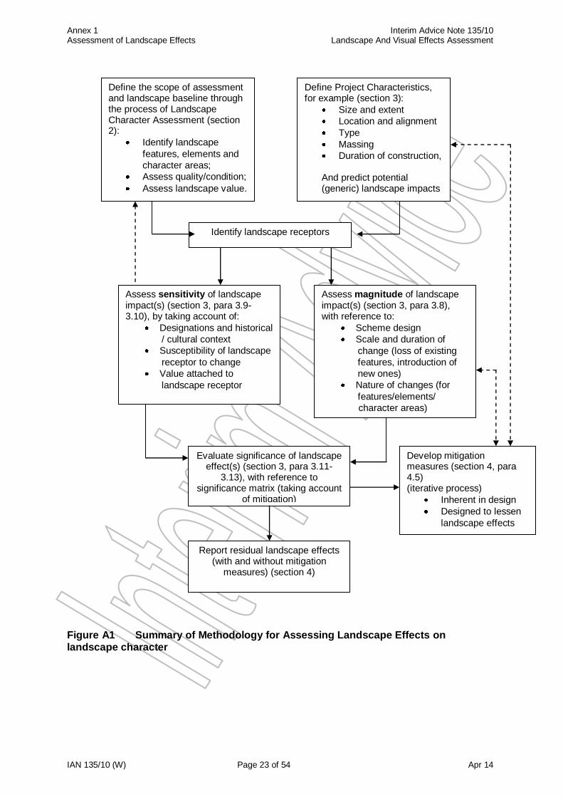
Assess cumulative impacts if appropriate. 1.4 This process is outlined in Figure A1.
Annex 1 Interim Advice Note 135/10 Assessment of Landscape Effects Landscape And Visual Effects Assessment
IAN 135/10 (W) Page 23 of 54 Apr 14
Figure A1 Summary of Methodology for Assessing Landscape Effects on landscape character
Define Project Characteristics, for example (section 3):
Size and extent
Location and alignment
Type
Massing
Duration of construction,
And predict potential (generic) landscape impacts
Define the scope of assessment and landscape baseline through the process of Landscape Character Assessment (section 2):
Identify landscape
features, elements and
character areas;
Assess quality/condition;
Assess landscape value.
Assess magnitude of landscape impact(s) (section 3, para 3.8), with reference to:
Scheme design
Scale and duration of
change (loss of existing
features, introduction of
new ones)
Nature of changes (for
features/elements/
character areas)
Evaluate significance of landscape effect(s) (section 3, para 3.11-
3.13), with reference to significance matrix (taking account
of mitigation)
Develop mitigation measures (section 4, para 4.5) (iterative process)
Inherent in design
Designed to lessen
landscape effects
Report residual landscape effects (with and without mitigation
measures) (section 4)
Identify landscape receptors
Assess sensitivity of landscape impact(s) (section 3, para 3.9-3.10), by taking account of:
Designations and historical
/ cultural context
Susceptibility of landscape
receptor to change
Value attached to
landscape receptor
Annex 1 Interim Advice Note 135/10 Assessment of Landscape Effects Landscape And Visual Effects Assessment
IAN 135/10 (W) Page 24 of 54 Apr 14
2 Landscape Baseline Study
Study area
2.1 For landscape character, the study area should cover the proposed project site and the wider landscape context within which the project may influence landscape character.
2.2 The study area should also include the full extent of any neighbouring features of
special value. This could include the following:
National landscape designations such as National Parks, Areas of Outstanding Natural Beauty (AONBs), Heritage Coasts, Historic Parks and Gardens;
Ecological and historical designations such as Sites of Special Scientific Interest, Ramsar Sites, Special Areas of Conservation, World Heritage Sites, Scheduled Ancient Monuments;
Other designations (including Local Authority designations) such as Landscapes of Historic Interest in Wales, Conservation Areas, tranquil areas, dark sky reserves etc;
“important hedgerows” under the Hedgerow Regulations 1997; and
any general recognition of the interest of an area at a local level such as for example, a village green or community open space.
Inclusion of the above mentioned features should reflect the setting of that feature. The setting is defined in response to:
the contribution of the surroundings to the appearance of an area or feature, and;
the interrelationship of the area or feature to the wider context and sense of place.
Desk study
2.3 LandMAP landscape information system should be used as an initial baseline desk study exercise for obtaining all the relevant landscape character information available. The implementation of LandMAP and other preliminary analytical studies may then be used to inform and supplement the site survey. These analytical studies may include annotated mapping and cross sections which will provide a useful reference during the assessment process. An initial desk study will allow impressions of the site to be formed from available mapping (i.e. topography, geomorphology, vegetation and the wider geographical context).
2.4 A review of data collected should identify local and wider landscape character
together with the natural (e.g. geology/soils, landform, river/drainage systems and landcover/vegetation) and cultural/social factors (e.g. landuse, street pattern, historical background, open spaces and architectural styles) that have influenced the development of the landscape/townscape. The amount and quality of available desk based material will vary. The desk study should be tailored to meet the requirements of the particular project.
2.5 Statutory environmental bodies, local planning authorities, the relevant managing
agent and where appropriate, residents and local interest groups, should be contacted to provide supplementary data and to identify potential key issues. The following list is not intended to be prescriptive, but gives an indication of the type of aspects about which information could be collected:
Annex 1 Interim Advice Note 135/10 Assessment of Landscape Effects Landscape And Visual Effects Assessment
IAN 135/10 (W) Page 25 of 54 Apr 14
Features of special value listed in 2.2 above.
Current professional evaluations or studies, design guides, strategies or initiatives and current or future trends. Examples would include;
- LandMAP; - Character Area Map of Wales; - Local Authority design guidance; - any regional, county, district level or other landscape character
assessments (e.g. those that maybe included within environmental statements);
- initiatives by statutory bodies (e.g. the Forestry Commission Wales’ (now Natural Resource Wales) strategy for woodlands and trees and the Environment Agency’s river habitat surveys, where appropriate.
Past and future trends and forces for landscape change. Examples would include;
- future developments with planning permission; - trends in land management or farming practice; - long term management of the soft estate; - the future growth of existing vegetation (or conversely future timber
harvesting of commercial woodland if appropriate); - potential effects of climate change (e.g. on vegetation and related
ecological features which in turn affect the landscape).
Landuse/landcover and settlement patterns taken from historic data, aerial photographs and maps.
Past and present perceptions of value available from the regulatory authority, and if appropriate local amenity groups and residents.
Books, journals, and reports including reports on local architecture and history and, if available, Townscape and / or Seascape Character Assessments or Conservation Area Character Appraisals, and tourism studies.
Local or Unitary Development Plans, Supplementary Planning Guidance including Urban Design Frameworks, Development Strategies, Guides and Design Statements.
Cross references to other topics for data on planning policy, historic environment, biodiversity, community, and landscape (e.g. listed buildings, Scheduled Ancient Monuments, conservation areas etc.). In particular, the Interpretation of any Historic Landscape Characterisation study for the area (refer to the Cultural Heritage chapter), which will advise on the ‘time-depth’ dimension of the landscape and its historic integrity or continuity, where this is important to the character of the landscape.
Field Survey
2.6 Landscape Character Assessment is the process whereby the different elements that form the landscape are recorded and assessed. The process can be applied at local,
Annex 1 Interim Advice Note 135/10 Assessment of Landscape Effects Landscape And Visual Effects Assessment
IAN 135/10 (W) Page 26 of 54 Apr 14
regional and national levels, and the assessment for the project should set the landscape within its national and regional landscape character context.
2.7 The process involves the assessment of a combination of physical (e.g. landform,
vegetation, buildings), aesthetic/perceptual (e.g. scale, appearance, tranquillity) and cultural/social (e.g. human interaction, landuse, heritage) aspects which together make up the character of the area. An assessment is also made as to the quality, or condition, of the landscape, which involves consideration of the physical state of the landscape and of the features and elements which make up landscape character.
2.8 The end result in terms of providing the landscape baseline for the project is to divide
the study area into specific landscape character areas, with an assessment as to their quality/condition, together with a judgement as to the value of the landscape both as a whole and of the individual character areas, features and elements that make up the landscape and define its sense of place.
2.9 Landscape character types are defined as ‘distinct types of landscape that are
relatively homogeneous in character. They are generic in nature in that they may occur in different areas in different parts of the country, but wherever they occur they share broadly similar combinations of geology, topography, drainage patterns, vegetation and historical land use and settlement pattern’, whilst landscape character areas are ‘single unique areas and are the discrete geographical areas of a particular landscape type.’ (LCA 2002). Accordingly, character types would have generic names
(e.g. ‘valley side’), whereas character areas would take on the names of specific places.
2.10 The approach can also be used in urban areas, where the boundary to a character
area could be demarcated by building frontage, road, planting or change in land use or edge of settlement. Urban character types would have generic names reflecting the detailed typology of the built fabric (e.g. 1930’s semi detached housing), whilst urban character areas would take the names of specific places according to location, neighbourhood, age and cultural or historical association or designation (e.g. ‘Tredegar Park’).
2.11 Although the description of each type or area may run to several paragraphs, it
should be possible to summarise the essential character in one line. This could be a simple description of the landscape type (e.g. ‘coniferous woodland’) landscape type or a fuller description which conveys some sense of its qualities (e.g. ‘small scale intimate pasture’). Areas can be geographically specific (e.g. ‘Nantlle Valley’ landscape character area), with clear visual and physical identities, although in some cases the boundaries between areas may take the form of a transition rather than a precise line, which needs to be described within the report.
2.12 The purpose of the survey is to confirm and supplement the desk study data with
current information, which may not be reflected by reports, mapping or aerial photographs. Negative features which detract from the character of the area should also be noted, and whether or not there are opportunities for enhancement. The process should be supported by a comprehensive photographic record (recording the viewpoint position and date of the photograph) and annotated mapping completed during the survey. As with the desk study, the site survey should be tailored to meet the requirements of the particular project, bearing in mind the project objectives and the level of reporting required (i.e. Scoping, Simple or Detailed).
Annex 1 Interim Advice Note 135/10 Assessment of Landscape Effects Landscape And Visual Effects Assessment
IAN 135/10 (W) Page 27 of 54 Apr 14
2.13 The following list is not intended to be prescriptive, but gives an indication of the range of aspects that need to be considered;
Landcover, pattern and texture – the relationship between topography, scale, degree of enclosure and the way in which land is used. For example, pattern and texture will vary greatly depending on whether arable farming dominates over pastoral or vice versa. In urban areas it is influenced by the pattern of the arrangement of streets, plots and their buildings, architectural form and style, and the degree to which an area’s pattern of streets and junctions are either small and frequent (i.e. small grain) or large and infrequent (i.e. large grain).
Scale and appearance – the size of fields, woodlands, buildings and structures in
relation to their surroundings and whether or not the overall arrangement is balanced. In urban areas the height and size of built elements and facades in relation to other buildings and spaces determines effects on views, vistas and skylines. The distinctiveness of buildings and structures are influenced by their detail and materials. Detail refers to the craftsmanship, building techniques, façade treatment, styles and lighting. Materials refer to the texture, colour, pattern and durability and how they are used.
Tranquillity – the remoteness and sense of isolation, or lack of it, within the landscape, which is often determined by the presence or absence of built development and traffic.
Cultural – how landscape elements of an historic or traditional nature contribute to landscape character. Historical and topographical influences also play a large part in defining the layout of settlements (e.g. the original settlement layout may have been determined by landform or for defensive reasons, or to exploit a river for commerce), but note that consideration of this aspect should be cross referenced to the Cultural Heritage assessment to avoid issues of ‘double counting‘.
Human interaction – the way that people interact with the landscape and how activity is focused within a community. Some areas are very busy (e.g. a shopping mall), whereas others are more tranquil (e.g. a large park). Recognisable and locally distinct form with consistent patterns of elements, and/or distinctive features of development (i.e. historic or iconic new buildings), all influence how a landscape is used and valued. (These aspects may need to be cross referenced to the Community and Private Assets assessment).
2.14 Bearing in mind the above aspects, the following list (which is not intended to be
prescriptive) gives an indication of the range of attributes that would need to be considered;
Natural features and elements. Examples would include:
- landform (e.g. ridge lines); - trees and woodland (e.g. mature hilltop copse, scrub, or isolated trees); - any other natural vegetation (e.g. heathland); - water features (e.g. lakes, streams and ditches); - rock formations.
Annex 1 Interim Advice Note 135/10 Assessment of Landscape Effects Landscape And Visual Effects Assessment
IAN 135/10 (W) Page 28 of 54 Apr 14
Built features and elements. Examples would include;
- prominent buildings or other landmarks (e.g. a church spire or bridge); - settlements and built form (e.g. urban areas, villages, farms or houses); - settlement pattern and density (e.g. clustered, isolated or randomly
dispersed); - style and characteristics of the built landscape (e.g. old or modern, use of
local vernacular materials such as stone or thatch).
Historic features and elements. Examples would include;
- visible ancient monuments (e.g. earthworks, burial mounds and standing stones);
- visible historic features remaining from past farming and land management systems (e.g. ridge and furrow);
- historic buildings, bridges and other structures (e.g. memorials)
Features and elements of the managed landscape. Examples would include:
- hedgerow form or other boundary treatment (e.g. dry stone walling); - land use (e.g. arable, pasture, urban). - Infrastructure features and elements (e.g. roads, canals, railways)
Any discordant or intrusive features and elements, such as a conspicuous line of pylons or an area of derelict land.
Less tangible aesthetic and perceptual characteristics concerned with how the landscape is experienced and why, including professional judgment on tranquillity, wildness, intimacy, sense of place, scenic quality and other responses or impressions.
The overall level of background noise, noting any intermittent sources (e.g. aircraft or trains).
Seasonal changes, noting how the landscape changes with the seasons.
Night time changes, noting existing light sources and night time character.
2.15 Each of the above attributes should be assessed as to how they contribute or detract from the overall character and quality of the landscape. This exercise helps to identify what should be avoided, conserved or protected and what should be enhanced, and provides the basis to consider the sensitivity of the landscape to change as a result of the proposed project.
2.16 Based on the results of the desk study and field surveys, a judgement should also be
made as to the value of the landscape. This is based on consideration of character and quality (i.e. of the landscape as a whole and the features and elements that make up character and their condition), together with the value that has been placed upon the landscape by society. Value maybe recognised through designation (e.g. National Park or conservation area), but is often found in undesignated landscapes, particularly at the local level (e.g. an urban park or woodland adjacent to a village).

Annex 1 Interim Advice Note 135/10 Assessment of Landscape Effects Landscape And Visual Effects Assessment
IAN 135/10 (W) Page 29 of 54 Apr 14
2.17 It should be noted that whilst designated areas will tend to be highly valued, the majority of the country comprises undesignated areas which can still be of high quality and/or of great local importance. The local landscape is usually intimately understood by the people who live and work there, but its value is often overlooked or underestimated in landscape assessments. The character assessment should therefore take account of local public perception.
Annex 1 Interim Advice Note 135/10 Assessment of Landscape Effects Landscape And Visual Effects Assessment
IAN 135/10 (W) Page 30 of 54 Apr 14
3 Identification of Impacts and Assessment of the Significance of Landscape
Effects
3.1 Project proposals should be reviewed alongside the baseline data to identify sources
of potential impacts on the landscape in order to determine subsequent landscape effects.
3.2 In general, the following elements of the project should be examined:
Description and detail of the project design and layout;
Details contained in the project design that could cause temporary or permanent direct impacts, such as the nature and extent of proposed landtake, the location of any elevated parts of the works, demolition and other construction activity, vegetation clearance, drainage, lighting, signage and the treatment of kerbs, paving and other finishes;
Off site works such as site compounds, borrow pits, access routes and numbers of heavy construction vehicles etc.;
Aspects of the project that have the potential for indirect impacts, such as changes to the economic viability of the area and consequential impacts such as hedgerow removal and field amalgamation.
3.3 The assessment of landscape impacts should preferably be undertaken by the same
landscape professional who undertook or co-ordinated the baseline assessment/evaluation. The assessment should take account of seasonal differences to ensure that all aspects are covered (e.g. the difference made by trees in full summer foliage or bare branched in winter).
3.4 Effects on landscape character should be assessed by considering the components
that define character and their sensitivity to the type, scale and duration of the proposed change, taking into account any mitigation measures. In Wales, the assignment of significance before the consideration of the effectiveness of the design and committed mitigation measures should also be undertaken, allowing for the case or reason for and the effectiveness of mitigation to be described. Potential effects could include the following depending on the circumstances involved;
Potential effects on landform/drainage patterns/urban form/street pattern – the proposed project could affect the characteristics of the landform and drainage pattern, and may either follow the contours or run across the grain of the land, with potential changes in the attributes that define landscape character. In urban areas the project could change the building height to width ratios by altering road and space ratios (i.e. vertical and horizontal space ratios), leading to changes in the sense of enclosure and ways in which the spaces are used.
Potential effects on land cover/land use patterns/urban structure – the project could damage existing vegetation or fit within the existing vegetation structure, or could cut either across field patterns or fit within existing boundaries, leading to varying levels of landscape effects. In urban areas the pattern and interrelationship of routes and development could be altered, leading to changes in street patterns and accessibility.
Potential effects on cultural and historic associations – the project could affect the setting of a historic settlement or monument, or buildings and elements of a traditional or historic nature that contribute to the character of an area, leading to adverse effects on character. (Consideration of this aspect should be cross referenced to the Cultural Heritage assessment).
Annex 1 Interim Advice Note 135/10 Assessment of Landscape Effects Landscape And Visual Effects Assessment
IAN 135/10 (W) Page 31 of 54 Apr 14
Potential effects on perceptual aspects – the project could increase the levels of traffic noise and/or urban influence through landscape changes, leading to an adverse effect on the way the area is perceived, particularly in rural areas where tranquillity and wildness may be important aspects in defining character.
3.5 The assessment should be undertaken for both day and night time situations and
compared against the situation that would exist if the project were not to proceed (i.e. the ‘Do Minimum’), using the following scenarios:
In the winter of the year of opening (to represent a maximum effect situation, before any planted mitigation can take effect), taking account of the completed project and the traffic using it,
In the summer of the fifteenth year after project opening, (to represent a least effect scenario, where any planted mitigation measures can be expected to be reasonably effective), taking account of the completed project and the traffic using it; and
3.6 In assessing the effects of the project, specific details and their potential impact
should be considered, such as;
The relationship of the project to the existing ground levels and contours (including mounds, bunds, cuttings, false cuttings). For instance, a new road may be accommodated fairly easily within an undulating landscape, but more extensive earthworks may be required than would otherwise be the case in a flat landscape, where extensive cutting and embankment slopes could create adverse effects.
The relationship of the scale, extent and materials of the proposed project to those in the existing landscape, including side roads, junctions, structures, footpaths, cycleways and ancillary items such as safety barriers, drainage gulleys and kerb details.
The impact of traffic, including the proportion or frequency of high sided vehicles, and of vehicle headlights at night.
The height, scale, form (and lighting) of any gantries and road signs, together with other operational elements associated with the project such as service areas, lay-bys, treatment lagoons, noise barriers etc.
Temporary construction elements associated with the project such as extraction areas, borrow pits and site compounds etc.
Lighting, both as a permanent visual feature during the day and as a potentially intrusive element at night. Day time effects could arise from intrusion on the skyline, colour contrast with the background and the equipment itself (i.e. lighting arrangement, column height and shape, brackets and luminaire type). Night time effects could arise from the visibility of the new light sources, sky glow, glare, spillage, light reflection from the road surface and the illumination of moving traffic. Incremental and cumulative effects on dark skies should be considered. Use of isolux contours in dark landscapes may assist the assessment procedure, but note that effects can extend far beyond the area where changes in lux levels are significant; a receptor does not need to be directly illuminated in order to experience adverse effects. In remote/rural landscapes it may be appropriate to question the necessity of lighting and explore alternative safety solutions.
3.7 Computer visualisation techniques such as photomontages or 3 dimensional
animations can assist with the assessment, by generating images of the landscape with the proposed project and its traffic in place, and these can also be useful for consultation. However they are not a substitute for informed judgement.
Annex 1 Interim Advice Note 135/10 Assessment of Landscape Effects Landscape And Visual Effects Assessment
IAN 135/10 (W) Page 32 of 54 Apr 14
Assessing Magnitude of Impact
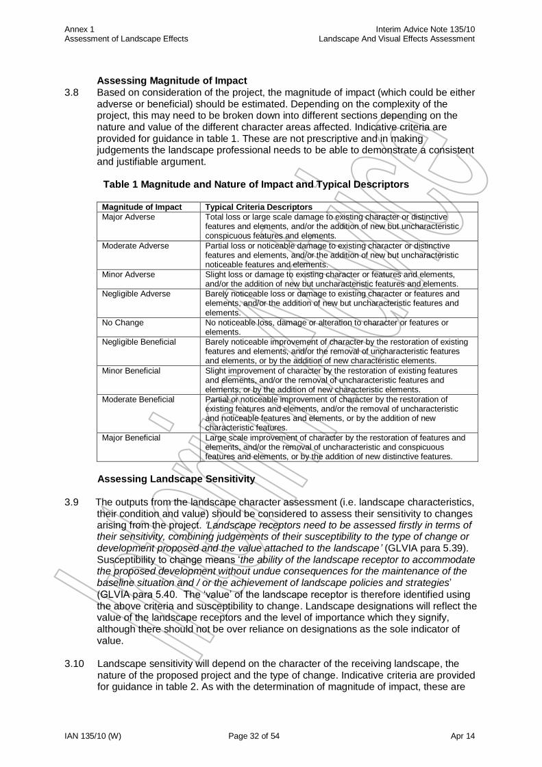
3.8 Based on consideration of the project, the magnitude of impact (which could be either adverse or beneficial) should be estimated. Depending on the complexity of the project, this may need to be broken down into different sections depending on the nature and value of the different character areas affected. Indicative criteria are provided for guidance in table 1. These are not prescriptive and in making judgements the landscape professional needs to be able to demonstrate a consistent and justifiable argument.
Table 1 Magnitude and Nature of Impact and Typical Descriptors
Magnitude of Impact Typical Criteria Descriptors
Major Adverse Total loss or large scale damage to existing character or distinctive features and elements, and/or the addition of new but uncharacteristic conspicuous features and elements.
Moderate Adverse Partial loss or noticeable damage to existing character or distinctive features and elements, and/or the addition of new but uncharacteristic noticeable features and elements.
Minor Adverse Slight loss or damage to existing character or features and elements, and/or the addition of new but uncharacteristic features and elements.
Negligible Adverse Barely noticeable loss or damage to existing character or features and elements, and/or the addition of new but uncharacteristic features and elements.
No Change No noticeable loss, damage or alteration to character or features or elements.
Negligible Beneficial Barely noticeable improvement of character by the restoration of existing features and elements, and/or the removal of uncharacteristic features and elements, or by the addition of new characteristic elements.
Minor Beneficial Slight improvement of character by the restoration of existing features and elements, and/or the removal of uncharacteristic features and elements, or by the addition of new characteristic elements.
Moderate Beneficial Partial or noticeable improvement of character by the restoration of existing features and elements, and/or the removal of uncharacteristic and noticeable features and elements, or by the addition of new characteristic features.
Major Beneficial Large scale improvement of character by the restoration of features and elements, and/or the removal of uncharacteristic and conspicuous features and elements, or by the addition of new distinctive features.
Assessing Landscape Sensitivity
3.9 The outputs from the landscape character assessment (i.e. landscape characteristics, their condition and value) should be considered to assess their sensitivity to changes arising from the project. ‘Landscape receptors need to be assessed firstly in terms of their sensitivity, combining judgements of their susceptibility to the type of change or development proposed and the value attached to the landscape’ (GLVIA para 5.39). Susceptibility to change means ‘the ability of the landscape receptor to accommodate the proposed development without undue consequences for the maintenance of the baseline situation and / or the achievement of landscape policies and strategies’
(GLVIA para 5.40. The ‘value’ of the landscape receptor is therefore identified using the above criteria and susceptibility to change. Landscape designations will reflect the value of the landscape receptors and the level of importance which they signify, although there should not be over reliance on designations as the sole indicator of value.
3.10 Landscape sensitivity will depend on the character of the receiving landscape, the
nature of the proposed project and the type of change. Indicative criteria are provided for guidance in table 2. As with the determination of magnitude of impact, these are

Annex 1 Interim Advice Note 135/10 Assessment of Landscape Effects Landscape And Visual Effects Assessment
IAN 135/10 (W) Page 33 of 54 Apr 14
not prescriptive and in making judgements the landscape professional needs to be able to demonstrate to others a consistent and justifiable argument that can be linked back to evidence from the baseline study.
Annex 1 Interim Advice Note 135/10 Assessment of Landscape Effects Landscape And Visual Effects Assessment
IAN 135/10 (W) Page 34 of 54 Apr 14
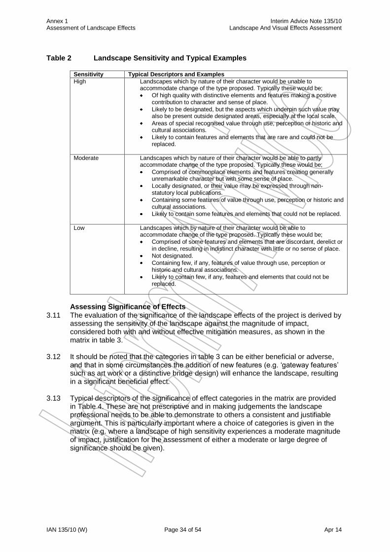
Table 2 Landscape Sensitivity and Typical Examples
Sensitivity Typical Descriptors and Examples
High Landscapes which by nature of their character would be unable to accommodate change of the type proposed. Typically these would be;
Of high quality with distinctive elements and features making a positive contribution to character and sense of place.
Likely to be designated, but the aspects which underpin such value may also be present outside designated areas, especially at the local scale.
Areas of special recognised value through use, perception or historic and cultural associations.
Likely to contain features and elements that are rare and could not be replaced.
Moderate Landscapes which by nature of their character would be able to partly accommodate change of the type proposed. Typically these would be;
Comprised of commonplace elements and features creating generally unremarkable character but with some sense of place.
Locally designated, or their value may be expressed through non-statutory local publications.
Containing some features of value through use, perception or historic and cultural associations.
Likely to contain some features and elements that could not be replaced.
Low Landscapes which by nature of their character would be able to accommodate change of the type proposed. Typically these would be;
Comprised of some features and elements that are discordant, derelict or in decline, resulting in indistinct character with little or no sense of place.
Not designated.
Containing few, if any, features of value through use, perception or historic and cultural associations.
Likely to contain few, if any, features and elements that could not be replaced.
Assessing Significance of Effects
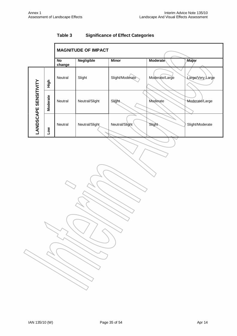
3.11 The evaluation of the significance of the landscape effects of the project is derived by assessing the sensitivity of the landscape against the magnitude of impact, considered both with and without effective mitigation measures, as shown in the matrix in table 3.
3.12 It should be noted that the categories in table 3 can be either beneficial or adverse,
and that in some circumstances the addition of new features (e.g. ‘gateway features’ such as art work or a distinctive bridge design) will enhance the landscape, resulting in a significant beneficial effect.
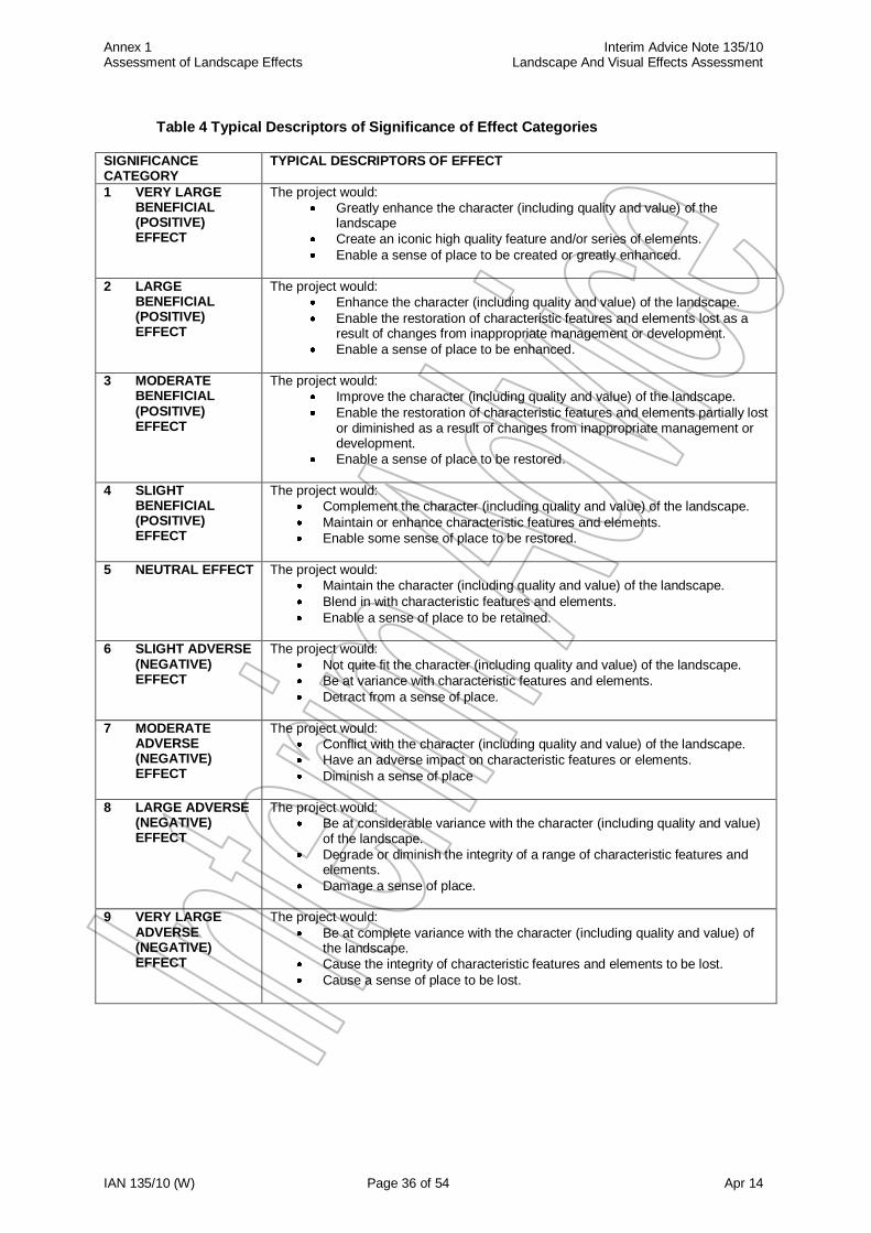
3.13 Typical descriptors of the significance of effect categories in the matrix are provided
in Table 4. These are not prescriptive and in making judgements the landscape professional needs to be able to demonstrate to others a consistent and justifiable argument. This is particularly important where a choice of categories is given in the matrix (e.g. where a landscape of high sensitivity experiences a moderate magnitude of impact, justification for the assessment of either a moderate or large degree of significance should be given).
Annex 1 Interim Advice Note 135/10 Assessment of Landscape Effects Landscape And Visual Effects Assessment
IAN 135/10 (W) Page 35 of 54 Apr 14
Table 3 Significance of Effect Categories
MAGNITUDE OF IMPACT
No change
Negligible Minor Moderate Major
LA
ND
SC
AP
E S
EN
SIT
IVIT
Y
Hig
h
Neutral
Slight
Slight/Moderate
Moderate/Large
Large/Very Large
Mo
dera
te
Neutral
Neutral/Slight
Slight
Moderate
Moderate/Large
Lo
w
Neutral
Neutral/Slight
Neutral/Slight
Slight
Slight/Moderate
Annex 1 Interim Advice Note 135/10 Assessment of Landscape Effects Landscape And Visual Effects Assessment
IAN 135/10 (W) Page 36 of 54 Apr 14
Table 4 Typical Descriptors of Significance of Effect Categories
SIGNIFICANCE CATEGORY
TYPICAL DESCRIPTORS OF EFFECT
1 VERY LARGE BENEFICIAL (POSITIVE) EFFECT
The project would:
Greatly enhance the character (including quality and value) of the landscape
Create an iconic high quality feature and/or series of elements.
Enable a sense of place to be created or greatly enhanced.
2 LARGE BENEFICIAL (POSITIVE) EFFECT
The project would:
Enhance the character (including quality and value) of the landscape.
Enable the restoration of characteristic features and elements lost as a result of changes from inappropriate management or development.
Enable a sense of place to be enhanced.
3 MODERATE BENEFICIAL (POSITIVE) EFFECT
The project would:
Improve the character (including quality and value) of the landscape.
Enable the restoration of characteristic features and elements partially lost or diminished as a result of changes from inappropriate management or development.
Enable a sense of place to be restored.
4 SLIGHT BENEFICIAL (POSITIVE) EFFECT
The project would:
Complement the character (including quality and value) of the landscape.
Maintain or enhance characteristic features and elements.
Enable some sense of place to be restored.
5 NEUTRAL EFFECT The project would:
Maintain the character (including quality and value) of the landscape.
Blend in with characteristic features and elements.
Enable a sense of place to be retained.
6 SLIGHT ADVERSE (NEGATIVE) EFFECT
The project would:
Not quite fit the character (including quality and value) of the landscape.
Be at variance with characteristic features and elements.
Detract from a sense of place.
7 MODERATE ADVERSE (NEGATIVE) EFFECT
The project would:
Conflict with the character (including quality and value) of the landscape.
Have an adverse impact on characteristic features or elements.
Diminish a sense of place
8 LARGE ADVERSE (NEGATIVE) EFFECT
The project would:
Be at considerable variance with the character (including quality and value) of the landscape.
Degrade or diminish the integrity of a range of characteristic features and elements.
Damage a sense of place.
9 VERY LARGE ADVERSE (NEGATIVE) EFFECT
The project would:
Be at complete variance with the character (including quality and value) of the landscape.
Cause the integrity of characteristic features and elements to be lost.
Cause a sense of place to be lost.
Annex 1 Interim Advice Note 135/10 Assessment of Landscape Effects Landscape And Visual Effects Assessment
IAN 135/10 (W) Page 37 of 54 Apr 14
4 Reporting
4.1 The differences in levels of reporting for Scoping, Simple and Detailed Landscape Assessments are outlined as follows:
Scoping Assessment
4.2 Information gathering for the Scoping Exercise should consist of a combination of preliminary site surveys and desk-based studies of readily available information, such as that held by the statutory environmental bodies, local authorities and National Park Authorities. It is aimed at identifying major constraints that may be affected by the project or may require further study, and whether or not the project has the potential to generate any significant landscape effects.
4.3 If the Scoping Exercise shows that further work is required, the selection of Simple or
Detailed Assessment will depend on consideration of:
the nature of the project (e.g. a maintenance project in an undesignated area is unlikely to need detailed landscape assessment);
the character (including quality and value) of the receiving landscape;
the reliability of the baseline data that is available;
the findings of the Scoping Exercise;
the level of detail of any previous assessments undertaken for the project, and whether the data were collected recently.
Simple Assessment
4.4 Landscape Baseline;
An appreciation of landscape character, comprising a review of any published character assessments, local perceptions and/or designations, together with the results of a site visit to gain an appreciation of the extent to which the landscape around the project is representative of the character described. Where no such assessments exist, or where the landscape around the project is not representative or has other distinctive characteristics, a general description of the landscape character around the project should be made, noting any particular features and/or elements that help to define (or detract from) landscape character. This appreciation should note the condition of the landscape and make an informed judgement as to its value.
4.5 Magnitude and Type of Impact;
The degree of change which the project would cause should be assessed, noting in particular the scale, duration and nature of potential changes on landscape character. A note should also be made of any mitigation measures that could reduce adverse effects.
4.6 Significance of Effect;
An assessment of the effects the project will have on the landscape, based on its sensitivity in relation to the project. This should state whether or not the project is likely to give rise to significant landscape effects and whether these are large or small, beneficial or adverse, temporary or permanent. If significant effects are anticipated or the outcome of the Simple Assessment is inconclusive (e.g. due to inadequate or incomplete data, requiring the need for more detailed surveys), then a recommendation for a Detailed Assessment should be made, stating the reasons for this decision and an outline of the further work that would be anticipated. In Wales, Significance of Effect is to be assessed, with and without mitigation.
Annex 1 Interim Advice Note 135/10 Assessment of Landscape Effects Landscape And Visual Effects Assessment
IAN 135/10 (W) Page 38 of 54 Apr 14
Detailed Assessment
4.7 Landscape Baseline;
Classification of the landscape into character areas, including a description of the key characteristics of each character area (including key negative features where appropriate) and an appraisal of their condition and value, together with a map showing the boundaries of different areas.
Acknowledgement of key elements, features or characteristics that are important or valued within the local context or in determining the local character (e.g. a green lane used as a footpath), and which provide a sense of place.
A photographic record. These should be numbered and cross-referenced to accurately plotted locations on an OS map of appropriate scale, which should also show the angle of view. The photographic survey should record important features and elements, variations in character and provide representative images of each character area.
4.8 Magnitude and Type of Impact;
A description should be provided of the project and its impact. This should include consideration of the total project (e.g. how well a new road alignment would fit the existing topography) as well as specific features of the design (e.g. the addition of new signage as part of an urban project). It should also include potential changes in landscape character away from the project (e.g. benefits due to the removal of traffic from a new bypass).
A description of the mitigation measures proposed to avoid, reduce or remedy any impacts. These measures are an integral part of the project, and the effects assessed will therefore be the net effects arising from the project complete with mitigation.
4.9 Significance of Effect;
A description of the landscape effects and their significance. This should be based on the sensitivity of the landscape in relation to the proposed project. It should include the effect of individual aspects of the proposed project as well as their combined effect (e.g. the road, plus its traffic, lighting and signage), and effects on the whole landscape (e.g. changes in character) as well as specific features and elements (e.g. loss of woodland or buildings). In Wales, Significance of Effect is to be assessed, with and without mitigation.
Annex 2 Interim Advice Note 135/10 Assessment of Visual Effects Landscape And Visual Effects Assessment
IAN 135/10 (W) Page 39 of 54 Apr 14
Annex 2 Assessment of Visual Effects Contents 1 Introduction
2 Identifying the Extent of Visibility
Determining the Zone of Theoretical Visibility (ZTV) Desk Study Field Survey Visual Receptors and their Sensitivity 3 Identification of Impacts and Assessment of the Significance of Visual Effects
Recording Visual Effects Mitigation Assessing Magnitude of Impact
Assessing Significance of Visual Effects 4 Reporting
Scoping Assessment
Simple Assessment Detailed Assessment

Annex 2 Interim Advice Note 135/10 Assessment of Visual Effects Landscape And Visual Effects Assessment
IAN 135/10 (W) Page 40 of 54 Apr 14
1 Introduction
1.1 This annex outlines the methodology to be used for the assessment of visual effects, and covers Scoping, Simple and Detailed Assessments. Differences between the three assessment levels are reflected by;
The potential for the project to give rise to significant visual effects (i.e. if no significant effects are predicted then a Detailed Assessment will not be required);
the degree to which the project design is defined (i.e. if details are unavailable then only a Scoping or Simple Assessment will be possible), and;
the level of survey data that is available (i.e. a greater level of survey work would need to be completed for a Detailed Assessment).
1.2 Guidance on the difference between the reporting outputs from the methodology for
each assessment level is provided in section 4. 1.3 The stages in the assessment are to:
Determine the extent of visibility of the proposals.
Collect and collate information on the visual context of the project.
Identify receptors and evaluate their sensitivity.
Describe the degree of visual change caused by the proposals.
Identify and develop mitigation measures as a component of the iterative design process to avoid, reduce and where possible remedy adverse effects.
Assess the significance of the resultant visual effects. 1.4 The process is shown in Figure 1
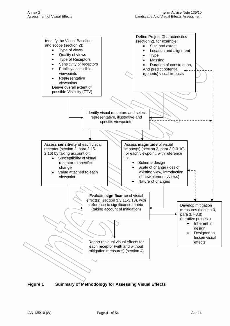
Annex 2 Interim Advice Note 135/10 Assessment of Visual Effects Landscape And Visual Effects Assessment
IAN 135/10 (W) Page 41 of 54 Apr 14
Figure 1 Summary of Methodology for Assessing Visual Effects
Define Project Characteristics (section 2), for example:
Size and extent
Location and alignment
Type
Massing
Duration of construction, And predict potential (generic) visual impacts
Identify the Visual Baseline and scope (section 2):
Type of views
Quality of views
Type of Receptors
Sensitivity of receptors
Publicly accessible
viewpoints
Representative
viewpoints Derive overall extent of possible Visibility (ZTV)
Assess magnitude of visual impact(s) (section 3, para 3.9-3.10) for each viewpoint, with reference to:
Scheme design
Scale of change (loss of
existing view, introduction
of new elements/views)
Nature of changes
Evaluate significance of visual effect(s) (section 3 3.11-3.13), with
reference to significance matrix (taking account of mitigation)
Develop mitigation measures (section 3, para 3.7-3.8) (iterative process)
Inherent in
design
Designed to
lessen visual
effects
Report residual visual effects for each receptor (with and without mitigation measures) (section 4)
Assess sensitivity of each visual receptor (section 2, para 2.15-2.16) by taking account of:
Susceptibility of visual
receptor to specific
change
Value attached to each
viewpoint
Identify visual receptors and select representative, illustrative and
specific viewpoints
Annex 2 Interim Advice Note 135/10 Assessment of Visual Effects Landscape And Visual Effects Assessment
IAN 135/10 (W) Page 42 of 54 Apr 14
2 Identifying the Extent of Visibility
2.1 For visual effects, the study area will extend to the whole of the area from which the project could be visible. For some projects this area will be contained by vegetation, topography or building frontages. Conversely, it is possible that other areas may have long distance views of the proposed development, perhaps from one or two upper floor windows of distant properties where the area of the development is overlooked by distant hills. Determining the Zone of Theoretical Visibility (ZTV)
2. Mapping the extent of visibility is referred to as either the Zone of Visual Influence (ZVI) or the Zone of Theoretical Visibility (ZTV). The ZTV is now the recommended process since ‘it makes clear that the area so defined only shows land from which the proposal may theoretically be visible. That is, it treats the world as ‘bare earth’ and does not take account of potential screening by vegetation or buildings’ (GLVIA para 6.8). The ZTV therefore shows the area of land from which there could theoretically be a view of any part of the proposed project (e.g. bridges, roads, gantries, lighting and traffic). The ZTV results are not intended to show the actual visibility of an object, they are only intended to indicate where the object ‘may’ be visible from. Actual visibility can only accurately be determined by site survey since there are a multitude of local variables that may affect lines of site. The assessment for the ZTV should therefore be verified by a site visit and be undertaken by an experienced landscape professional with detailed knowledge of the project proposals. The ZTV serves as a working tool, and can also be presented both to the public and in reports of the assessment as it provides an immediate and easily understood indication of the area within which potential visual effects may be experienced. The ZTV can be determined by computer analysis or by site assessment, or a combination of the two, but must always be checked on site to ensure accuracy and applicability.
2.3 The benefits of the ZTV process for road schemes is described in the GLVIA, ‘In the case of linear developments such as road schemes, the ZTV must be constructed for a sequence of points along the road, a process that can now easily be carried out digitally. In addition, the height of structures such as bridges or gantries, and of vehicles that will use the route, should be built into the ZTV construction so that visibility of all aspects of the proposal is considered’ (GLVIA para 6.9). It is important to note that the ZTV is by its nature approximate only. In some cases it may be necessary to prepare ZTV’s at different scales to cover both long distance views and detail close to the project. Conversely, some areas within the ZTV may not have views of the proposed development due to local screening (landform or vegetation), and any such areas should be shown graphically on the ZTV map.
2.4 ZTV’s should be prepared to illustrate the full range of visibility that could potentially
result from the project. Typically this would involve the scenario of winter in the year of opening (i.e. to represent a maximum effect situation, before any planted mitigation can take effect), and summer in the fifteenth year after opening (i.e. to represent a least effect scenario, when any planted mitigation can be expected to be reasonably effective). For projects of an extensive nature or long duration it may also be necessary to prepare a ZTV for the construction phase of the project.
2.5 For projects where the new work is an incremental change to an existing road (e.g.
upgrading an existing junction, or widening an existing carriageway) it may also be helpful to prepare separate ZTV’s to illustrate the existing situation and the proposed new works in order to facilitate determination of the degree of change resulting from the project. It should also be noted that for more extensive projects, different ZTV’s may be required relevant to different sections or parts of the project.
Annex 2 Interim Advice Note 135/10 Assessment of Visual Effects Landscape And Visual Effects Assessment
IAN 135/10 (W) Page 43 of 54 Apr 14
2.6 The ZTV can be progressively refined throughout the course of a project, with increasing definition as the project proceeds and the design becomes more detailed. In addition, if the ZTV has been prepared some time previously, or if the project changes, it should be checked to ensure that it is still accurate. Desk Study
2.7 The extent of the project should be marked on a contoured Ordnance Survey base, noting areas where (if applicable) it would be in cutting and where traffic would therefore be screened (though note the possibility of views from higher ground, and that some components such as lighting columns or gantries could still be visible above the top of the cutting). Where there is an appreciable slope across the line of the project it may be necessary to consider the two sides independently. It may also be helpful to mark levels on the map to indicate the maximum height of the components of the project, typically the proposed carriageway height plus (say) 4.5m for traffic and (say) 10m for lighting columns. Any proposed mounding or environmental barriers should also be shown, where their locations are known.
2.8 A study of contoured Ordnance Survey mapping and aerial photographs should also
be made to identify potential screening features (generally tree lines, woodland blocks or urban areas/large individual buildings) for later verification on site. In urban areas, the first line of buildings usually forms the principal screen to visibility and views from beyond this are often partial or fragmented. This information should enable a preliminary assessment of the extent of the ZTV to be made before going on site. Potential visual receptors such as residential properties, Public Rights of Way (and noting whether they are National Trails, footpaths, bridleways etc.) and recreation or amenity areas should also be noted for more detailed assessment on site.
2.9 Consultation with key stakeholders such as Statutory Environmental Bodies, National Park Authorities, Local Planning Authorities and local community groups etc. should be undertaken at this stage to agree key views and representative viewing points to be used in the assessment. Site Survey
2.10 A site visit is always required to verify and expand upon the results of the desk study. This should include assessing the nature of views and number/type of receptors looking towards the project, as well as looking out from the project location to determine which areas and receptors are visible and to be able to make an informed judgement about the degree of change in the view that would be caused by the project (e.g. some residential properties may only have a view from upper floor windows). It should be noted that the components of the proposed project are likely to be higher than eye level height (which is typically 1.5 m), and that the proposed project may be higher or lower than the surrounding landform.
2.11 Where access to the land on which the project will take place is not possible,
estimates of the nature of the view and number of receptors affected must be made from the nearest areas with public access, though where necessary, powers of entry may be available. Landmarks or other features within or close to the site should be noted as reference points for use when looking back towards the site from the surrounding landscape. The site assessment must also note the location, height and screening value of any visually significant vegetation and whether or not it forms a complete or partial screen, also noting how this may be affected in winter.
2.12 Viewpoints should be accurately recorded on a plan noting the direction of view. In
addition, all Public Rights of Way within the ZTV should be walked to assess potential
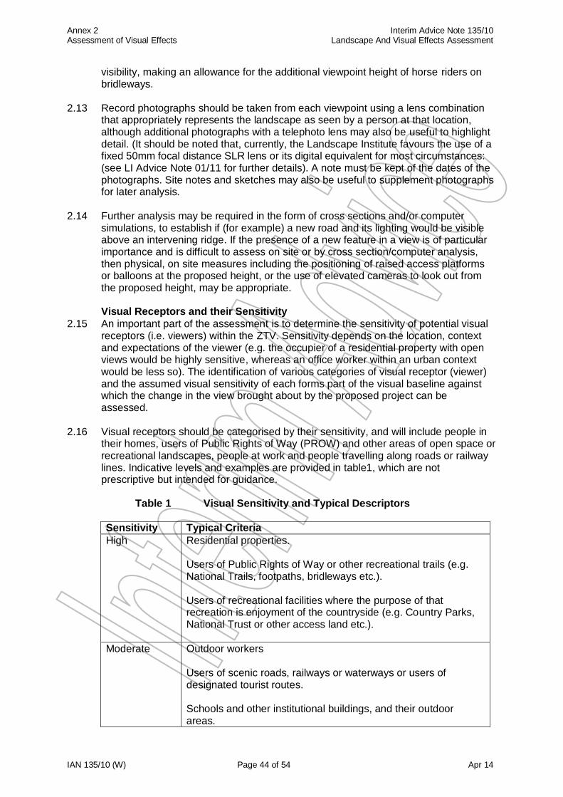
Annex 2 Interim Advice Note 135/10 Assessment of Visual Effects Landscape And Visual Effects Assessment
IAN 135/10 (W) Page 44 of 54 Apr 14
visibility, making an allowance for the additional viewpoint height of horse riders on bridleways.
2.13 Record photographs should be taken from each viewpoint using a lens combination
that appropriately represents the landscape as seen by a person at that location, although additional photographs with a telephoto lens may also be useful to highlight detail. (It should be noted that, currently, the Landscape Institute favours the use of a fixed 50mm focal distance SLR lens or its digital equivalent for most circumstances: (see LI Advice Note 01/11 for further details). A note must be kept of the dates of the photographs. Site notes and sketches may also be useful to supplement photographs for later analysis.
2.14 Further analysis may be required in the form of cross sections and/or computer
simulations, to establish if (for example) a new road and its lighting would be visible above an intervening ridge. If the presence of a new feature in a view is of particular importance and is difficult to assess on site or by cross section/computer analysis, then physical, on site measures including the positioning of raised access platforms or balloons at the proposed height, or the use of elevated cameras to look out from the proposed height, may be appropriate. Visual Receptors and their Sensitivity
2.15 An important part of the assessment is to determine the sensitivity of potential visual receptors (i.e. viewers) within the ZTV. Sensitivity depends on the location, context and expectations of the viewer (e.g. the occupier of a residential property with open views would be highly sensitive, whereas an office worker within an urban context would be less so). The identification of various categories of visual receptor (viewer) and the assumed visual sensitivity of each forms part of the visual baseline against which the change in the view brought about by the proposed project can be assessed.
2.16 Visual receptors should be categorised by their sensitivity, and will include people in
their homes, users of Public Rights of Way (PROW) and other areas of open space or recreational landscapes, people at work and people travelling along roads or railway lines. Indicative levels and examples are provided in table1, which are not prescriptive but intended for guidance.
Table 1 Visual Sensitivity and Typical Descriptors
Sensitivity Typical Criteria
High Residential properties. Users of Public Rights of Way or other recreational trails (e.g. National Trails, footpaths, bridleways etc.). Users of recreational facilities where the purpose of that recreation is enjoyment of the countryside (e.g. Country Parks, National Trust or other access land etc.).
Moderate Outdoor workers Users of scenic roads, railways or waterways or users of designated tourist routes. Schools and other institutional buildings, and their outdoor areas.

Annex 2 Interim Advice Note 135/10 Assessment of Visual Effects Landscape And Visual Effects Assessment
IAN 135/10 (W) Page 45 of 54 Apr 14
Low Indoor workers Users of main roads (e.g. trunk roads) or passengers in public transport on main arterial routes. Users of recreational facilities where the purpose of that recreation is not related to the view (e.g. sports facilities).
Annex 2 Interim Advice Note 135/10 Assessment of Visual Effects Landscape And Visual Effects Assessment
IAN 135/10 (W) Page 46 of 54 Apr 14
3 Identification of Impacts and Assessment of the Significance of Visual Effects
3.1 The assessment of visual effects should be undertaken for the following scenarios:
During the construction period, assuming a maximum visibility or maximum perceived change situation (i.e. when construction activity is at its peak for any given view), and noting how long that period would be likely to last;
A winter’s day in the year that the project would open to traffic or be fully operational (i.e. with noise/visual screens and mounds in place but before any planted mitigation has begun to take effect). This is usually a reflection of the operationally non-fully mitigated/maximum visibility scenario;
A summer’s day in the fifteenth year after opening (i.e. when the planted mitigation measures can be assumed to be substantially effective). This is usually a reflection of the near fully mitigated scenario under normal conditions. (Note however, that planting may be subject to adverse local conditions such as exposure or high altitude, which may require a longer assessment date to be determined);
Recording Visual Effects
3.2 The assessment should be recorded by means of the ZTV map, together with a Visual Effects Drawing (VED), and accompanying Visual Effects Schedule (VES).
3.3 The ZTV map should be presented on a contoured OS base, showing;
the line of the new road or other project;
significant screening features;
the limit of the ZTV. It may be appropriate, especially in cases where the boundary to the ZTV is a zone of transition rather than a precise line (i.e. in a very flat landscape), to illustrate this graphically by means of a graduated tone or by different line thicknesses;
A note to the effect that the boundary shown is not always precise and is an indication only of the area within which the most significant visual effects may be expected;
the principal representative viewpoints. These need not be exhaustive, but could cover the principal types and range of views of the proposed project which would be possible;
the full extent of the visibility of the project (noting that this may require several ZTV’s as described in paragraph 2.4).
3.4 The VED should be presented on a contoured OS base, showing;
Buildings and important outdoor locations which would be affected, such as viewpoints, roads and Public Rights Of Way (PROWs), with lengths affected/unaffected highlighted in the case of footpaths;
Each location cross referenced to the VES by means of a unique number, which should be colour coded to show graphically the difference across the scheme for construction, winter year 1 and summer year 15 scenarios;
Major visual barriers such as ridge lines, tree belts, woodlands and intervening buildings or structures;
For a proposed road, it should note any sections which will be in cuttings of 4.5m or greater depth (i.e. which would effectively screen the tallest vehicles);
The direction of the principal view (or arc view if appropriate) from individual locations.
Annex 2 Interim Advice Note 135/10 Assessment of Visual Effects Landscape And Visual Effects Assessment
IAN 135/10 (W) Page 47 of 54 Apr 14
3.5 Separate schedules should be prepared for different receptor groups (e.g. residential properties, community facilities, commercial properties, rights of way etc.). Properties may also be grouped together by location, or where their impacts are the same, to simplify the schedule where necessary. The VES should record the following information for each location assessed;
Reference number from the VED.
Location, by address and property name/number.
Number of properties at that location, where grouped.
Type of property - industrial, commercial, residential etc., and if residential, further detail such as number of storeys, size of windows and property elevation etc.
For PROWs and roads, length of route affected; for other recreational locations such as common land or open space, the approximate area affected.
Distance of the location from the nearest visible portion of the project (to the centre line for roads), but also noting whether other portions of the project may be visible. For a large receptor, the distance could be to the portion most affected, and this should be noted in the VES. For PROWs, a range of distance may be appropriate.
Description of existing view(s) towards location of project;
Description of change in view(s) resulting from project;
Level of visual effects and whether beneficial or adverse, for each of the scenarios outlined above (i.e. construction, winter year 1 and summer year 15);
Any explanatory notes. These would include the nature or angle of the view (e.g. oblique), and whether or not the views are screened or filtered by intervening vegetation, or marred by the presence of existing intrusive features (including roads and traffic). The number and location (e.g. ground floor, first floor etc) of windows overlooking the project should be noted (this may be impractical for projects overlooked by large numbers of properties, but is likely to be critical where a few properties/windows only are involved), as should the influence of proposed cuttings, embankments or mitigation measures. Note should also be made as to whether the view would be of the whole of the proposed project or just a part (i.e. lighting, gantries or a small component of it).
3.6 The visual assessment should note the date(s) and weather conditions on which the
site survey was carried out. Depending on the complexity of the project, additional material may be necessary to further illustrate existing and proposed views, such as cross sections, photographs, artist’s impressions or computer generated visualisations. Mitigation
3.7 The assessment of the visual effects of the project should take account of any mitigation measures proposed. These may be solid barriers, such as fences or earth mounds, which would be effective from the first day of opening, or screen planting which would take a number of years to become effective.
3.8 It should be noted that although such measures could effectively screen views of
traffic from the receptor, the mitigation measures themselves could cause visual intrusion, thus, for example, a large mound designed to screen traffic from properties could itself block a currently open view with subsequent adverse visual effects.
Annex 2 Interim Advice Note 135/10 Assessment of Visual Effects Landscape And Visual Effects Assessment
IAN 135/10 (W) Page 48 of 54 Apr 14
Assessing Magnitude of Impact
3.9 It is important to recognise that the assessment records the degree of change in the composition of the view, from that which would exist if the project were not completed to that which would result as a consequence of the project. In determining the magnitude of impact, or degree of change, the following should be considered;
Scale of change - a large scale project such as a new motorway would generate a
greater magnitude of change than would a small scale change such as a junction improvement. This change can be in the form of the addition of new features into the view or the removal of existing features (such as trees, woodland or buildings). It should also be noted that a relatively small scale project may constitute a major change within a very restricted, enclosed view.
Nature of change - the extent to which a given change is out of character with the
existing view can influence the effects which it would produce. For example, it is likely that the introduction of a new road into a view already containing other busy roads would be more in keeping with the existing character than the introduction of the same road into a presently rural view with few signs of development.
Duration of change - it is important to consider if the change is permanent or temporary, and to what extent it would reduce over time as mitigation planting matures. Change should be categorised as being short term (i.e. up to 1 year or during construction if the construction period exceeds one year), short/medium term (i.e. 1 to 5 years, during which time new planting will have little significant effect in most cases), medium/long term (5 to 15 years, when planted mitigation will begin to take increasing effect) or long term (i.e. lasting beyond 15 years).
Distance - the magnitude of any change would generally decrease with distance
from its source, until a point is reached where there is no discernible change.
Screening - intervening features may block the view completely (in which case there would be no change), or there may be a partial screen, in which case the magnitude of change would decrease. For instance, intervening features (e.g. other structures or vegetation) may filter a view, which in the case of vegetation may also change with the seasons, and this must be taken into account where appropriate.
The direction and focus of the view - if the change occurs in the part of the landscape which is the principal area of existing visual interest, the effects are likely to be perceived to be greater than if the proposed change occurs away from the main area of visual interest. This is especially relevant in the context of views from within houses (which are effectively framed by their windows), or from gardens (where views are often restricted by vegetation), and from promoted or locally valued viewpoints.
Removal of past mitigation or existing vegetation - for road widening or
improvement projects, consideration must be given to the effects of any removal of planting or other mitigation provided as part of an earlier project or existing vegetation. Removal of such mitigation may increase effects from the original road, and a check should be made as to whether any commitments were made in a past environmental statement or at a Public Inquiry as to the provision and maintenance of that mitigation.
Annex 2 Interim Advice Note 135/10 Assessment of Visual Effects Landscape And Visual Effects Assessment
IAN 135/10 (W) Page 49 of 54 Apr 14
Whether the receptor is static or moving - if the receptor is static (for example an
occupier of a residential property) then the view will be constant and greater emphasis should be placed upon it. If however the receptor is moving (for example along a Public Right of Way) then the view will be constantly changing, and the proposed project may only be visible for part of the time. Some consideration should therefore be given to how the change in the view affects the overall experience of walking along a given Right of Way (or for a long distance route, a discrete section of the Right of Way).
Numbers and types of receptors potentially affected at a viewpoint (e.g. a popular
viewpoint, busy trunk road, little-used path or minor lane).
3.10 The magnitude of impact, or degree of change, should be assessed using the indicative criteria in table 2. These are not prescriptive and are intended for guidance, and in making judgements the landscape professional needs to be able to demonstrate to others a consistent, structured, transparent and justifiable approach.
Table 2 Magnitude of Impact and Typical Descriptors
Magnitude of impact Typical criteria descriptors
Major The project, or a part of it, would become the dominant feature or focal point of the view.
Moderate The project, or a part of it, would form a noticeable feature or element of the view which is readily apparent to the receptor.
Minor The project, or a part of it, would be perceptible but not alter the overall balance of features and elements that comprise the existing view.
Negligible Only a very small part of the project would be discernable, or it is at such a distance that it would form a barely noticeable feature or element of the view.
No change No part of the project, or work or activity associated with it, is discernible.
Assessing Significance of Visual Effects 3.11 The evaluation of the significance of the visual effects of the project is derived by
assessing the sensitivity of the receptor (table 1) against the degree of change in the view resulting from the project (Magnitude of Impact) (table 2). These aspects can be combined to form a significance matrix as shown in Table 3. Typical descriptors of the significance levels in the matrix are provided in Table 4. As with the determination of receptor sensitivity and degree of change, these are not prescriptive and are intended for guidance.
3.12 In general terms a major magnitude of change on a highly sensitive receptor will
produce an effect of high significance, and a minor magnitude of change on a less sensitive receptor will produce an effect of low or negligible significance. Major changes for less sensitive receptors and minor changes for more sensitive receptors could also produce significant levels of effect.
3.13 It should be noted however that it is not possible to set out a precise formula for the
determination of the significance of effect as every case is different, and it is therefore important that the significance level determined is supported by reasoned justification in the form of a written explanation (supported by photographs and other illustrations as appropriate), so that the basis for the assessment is clear. This is particularly important where a choice of categories is given in the matrix (e.g. where a highly sensitive receptor experiences a moderate magnitude of impact, justification for the assessment of either a moderate or large degree of significance should be given).
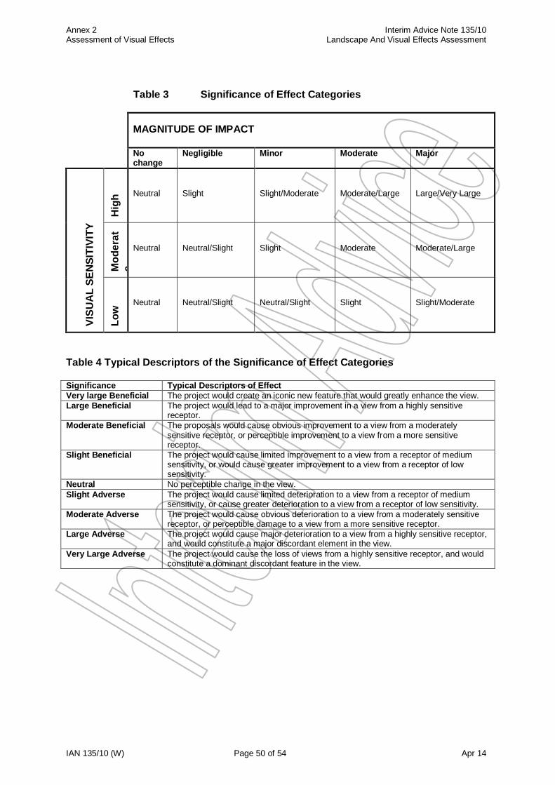
Annex 2 Interim Advice Note 135/10 Assessment of Visual Effects Landscape And Visual Effects Assessment
IAN 135/10 (W) Page 50 of 54 Apr 14
Table 3 Significance of Effect Categories
MAGNITUDE OF IMPACT
No change
Negligible Minor Moderate Major
VIS
UA
L S
EN
SIT
IVIT
Y
Hig
h
Neutral
Slight
Slight/Moderate
Moderate/Large
Large/Very Large
Mo
de
rat
e
Neutral
Neutral/Slight
Slight
Moderate
Moderate/Large
Lo
w
Neutral
Neutral/Slight
Neutral/Slight
Slight
Slight/Moderate
Table 4 Typical Descriptors of the Significance of Effect Categories
Significance Typical Descriptors of Effect
Very large Beneficial The project would create an iconic new feature that would greatly enhance the view.
Large Beneficial The project would lead to a major improvement in a view from a highly sensitive receptor.
Moderate Beneficial The proposals would cause obvious improvement to a view from a moderately sensitive receptor, or perceptible improvement to a view from a more sensitive receptor.
Slight Beneficial The project would cause limited improvement to a view from a receptor of medium sensitivity, or would cause greater improvement to a view from a receptor of low sensitivity.
Neutral No perceptible change in the view.
Slight Adverse The project would cause limited deterioration to a view from a receptor of medium sensitivity, or cause greater deterioration to a view from a receptor of low sensitivity.
Moderate Adverse The project would cause obvious deterioration to a view from a moderately sensitive receptor, or perceptible damage to a view from a more sensitive receptor.
Large Adverse The project would cause major deterioration to a view from a highly sensitive receptor, and would constitute a major discordant element in the view.
Very Large Adverse The project would cause the loss of views from a highly sensitive receptor, and would constitute a dominant discordant feature in the view.
Annex 2 Interim Advice Note 135/10 Assessment of Visual Effects Landscape And Visual Effects Assessment
IAN 135/10 (W) Page 51 of 54 Apr 14
4 Reporting
4.1 The differences in levels of reporting for Scoping, Simple and Detailed visual assessments are outlined as follows;
Scoping Assessment
4.2 Information gathering for the Scoping exercise should consist of a combination of preliminary site surveys and desk-based studies of readily available information, such as OS mapping, to determine potential visual receptors. It is aimed at identifying major constraints that may be affected by the project or may require further study, and whether or not the project has the potential to generate any significant visual effects.
4.3 If the Scoping Exercise shows that further work is required, the selection of Simple or
Detailed Assessment will depend on consideration of:
the nature of the project (e.g. a maintenance project on a heavily trafficked trunk road is unlikely to need detailed visual assessment);
the number and sensitivity of visual receptors (i.e. if a large number of residential properties are likely to be affected then detailed assessment would be required);
the findings of the Scoping Exercise; and
the findings of any previous assessments undertaken for the project, and whether the data were collected recently.
Simple Assessment 4.4 Visual Baseline;
An initial assessment of the visibility of the project within the landscape should be made, determined from mapping and by observation of the area of the project from public vantage points. Settlements and prominent viewpoints should be noted, together with an initial appreciation of their visual amenity and sensitivity to change. Detailed ZTV’s are not required for a Simple Assessment, but some illustrative material will be useful to explain the visual context (e.g. location of key settlements and viewpoints in relation to the project).
4.5 Magnitude and Type of Impact;
The scale, type and duration of change which the project would potentially bring to existing views and visual receptors should be assessed in outline terms and recorded.
4.6 Significance of Effect; An assessment of the effects of the project on visual receptors in broad terms (a Visual Effects Drawing and Visual Effects Schedule as defined in paragraphs 3.4 and 3.5 will not be required for a Simple Assessment) should be made, stating if the project is likely to give rise to significant visual effects and whether these are beneficial or adverse, temporary or permanent. This assessment should include an estimate of the type, approximate number and location of receptors that are likely to experience visual effects. In Wales, Significance of Effect is to be assessed, with and without mitigation.
Annex 2 Interim Advice Note 135/10 Assessment of Visual Effects Landscape And Visual Effects Assessment
IAN 135/10 (W) Page 52 of 54 Apr 14
Detailed Assessment
4.7 Visual Baseline;
Maps to show the potential Zone of Theoretical Visibility (ZTV), determined from mapping and/or computer generation and by observation, of the area of the project from public vantage points, as defined in paragraph 3.3. Settlements, groups of buildings, individual properties and other visual receptors within the ZTV (such as users of footpaths) should be noted, together with an assessment of their visual amenity and sensitivity to change. The importance of local landmarks and viewpoints, and the assessment of the extent and direction of views from properties should be recorded. The assessment should also take into consideration any committed development (i.e. developments with planning consent and/or development allocations in adopted local plans).
A description of the potential visual receptors (including key viewers) that would be affected by the proposed project, the extent and quality (amenity) of their existing views and an assessment of their sensitivity.
A photographic record showing views from key and representative visual receptors. These should be numbered and cross-referenced to accurately plotted locations on an OS map of appropriate scale, which should also show the angle of view.
4.8 Magnitude and type of Impact;
A description of the likely changes that will result in the view from key receptors (e.g. principle viewpoints and properties) as a result of the project.
A description of the mitigation measures proposed to avoid, reduce or possibly remedy any impacts. These measures are an integral part of the project, and the effects assessed will therefore be the net effects arising from the project complete with mitigation.
4.9 Significance of Effect;
A description of the visual effects of the proposed project for each group of visual receptors and their significance, including key views and users of footpaths, transport routes etc.
An OS based plan showing the visual effects of the proposed project on residential properties and other important receptors and viewpoints, illustrated to show the location of the properties affected and the degree to which they may be affected. This would comprise a Visual Effects Drawing and a Visual Effects Schedule, as defined in paragraphs 3.4 and 3.5 respectively.
In Wales, Significance of Effect is to be assessed, with and without mitigation.
Annex 3 Interim Advice Note 135/10 Glossary Landscape And Visual Effects Assessment
IAN 135/10 (W) Page 53 of 54 Apr 14
ANNEX 3 GLOSSARY
(Definitions are taken from LCA and GLVIA) Landscape Character A distinct, recognisable and consistent pattern of elements in the
landscape that makes one landscape different from another, rather than better or worse. Landscape Characteristics Elements, or combinations of elements, which make a
particular contribution to distinctive character. Landscape Elements Individual components which make up the landscape, such as trees
and hedges. Landscape Features Particularly prominent or eye-catching elements, like tree clumps,
church towers, or wooded skylines. Landscape Quality (or Condition) is based on judgements about the physical state of the
landscape, and about its intactness, from visual, functional, and ecological perspectives. It also reflects the state of repair of individual features and elements which make up the character in any one place. Landscape Resource The combination of elements that contribute to landscape context,
character, and value. Landscape Sensitivity The extent to which a landscape can accept change of a particular
type and scale without unacceptable adverse effects on its character. Landscape Value The relative value or importance attached to a landscape (often as a
basis for designation or recognition), which expresses national or local consensus, because of its quality, special qualities including perceptual aspects such as scenic beauty, tranquillity or wildness, cultural associations or other conservation issues. Receptor Physical landscape resource, special interest or viewer group that will experience an effect. Sense of Place (genius loci) The essential character and spirit of an area: genius loci literally means ‘spirit of the place’. Visual Amenity The value of a particular area or view in terms of what is seen.
Zone of Theoretical Visibility Area within which a proposed development may have an
influence or effect on visual amenity.
Annex 6 Interim Advice Note 135/10 DBFO Annex Landscape and Visual Effects Assessment
IAN 135/10 (W) Page 54 of 54 Apr 14
ANNEX 4 Bibliography
Highways Agency, 2010: Interim Advice Note 135/10 Landscape and Visual Effects Assessment. Highways Agency, 2007: Assessing the Effect of Road Schemes on Historic Landscape Character. HMSO. The Landscape Institute and the Institute of Environmental Management and Assessment, 2013: Guidelines for Landscape and Visual Impact Assessment, (3rd edn.). Spon Press. The Landscape Institute, 2011: Use of Photography and Photomontage in Landscape and Visual Assessment. Advice Note 01/11
Swanwick, C. and Land Use Consultants, 2002: Landscape Character Assessment Guidance for England and Scotland. Scottish Natural Heritage and the Countryside Agency.
Council of Europe, Florence, Adopted 20 October 2000: European Landscape Convention.
ETS 176. The Environment Act (England and Wales) 1995. The Countryside and Rights of Way Act 2000. The Hedgerow Regulations 1997. LandMAP Methodology, published 2008. Roads in Upland Areas, published in 1990 by the Welsh Government. Roads in Lowland Areas, published in 1993 by the Welsh Government.
National Resources Wales website for LandMAP. National Resources Wales Guidance notes on LANDMAP - Guidance note 3 – ‘Landscape and Visual Impact Assessment for onshore windfarms’, 2008; and Guidance note 4 – ‘LANDMAP and the Cultural Landscape’, 2013