Embed Size (px)
Citation preview

International Show Caves Association6th Congress
October 18 – 23, 2010Demänovská Valley, Slovakia
Contents
Introduction to Slovakia ............................................................................................................................ 3Karst and Caves in Slovakia ...................................................................................................................... 5Congress Venue and Surrounding .......................................................................................................... 8General Programme .................................................................................................................................. 10Abstracts ....................................................................................................................................................... 11ISCA Draft Management Guidelines for Show Caves ...................................................................... 36New ISCA Website ..................................................................................................................................... 40Excursion Guide ..........................................................................................................................................44
© State Nature Conservancy of the Slovak Republic Slovak Caves Administration, Liptovský Mikuláš Editors: Pavel Bella, Peter Gažík, Lukáš VlčekPublishing manager: Bohuslav Kortman, Knižné centrum Graphics: Ján Kasák, M&P® spol. s r. o.Print: BTO print, Žilina, Slovak Republic
ISBN 978-80-8064-391-1
Cover photographs and maps:(1) Demänovská Cave of Liberty. Photo by M. Rengevič(2) Route of the all-day excursion on October 20, 2010. Compiled by P. Gažík(3) Route of the all-day excursion on October 23, 2010. Compiled by P. Gažík(4) Dobšinská Ice Cave. Photo by M. Rengevič

3
Introduction to Slovakia
The Slovak Republic (Slovakia) is a state in Central Europe (17° – 22° E, 47° – 49° N). It has an area of 49,035 km2. Slovakia is a landlocked country bordered by the Czech Republic and Austria to the west, Poland to the north, Ukraine to the east and Hungary to the south. Slovakia is a mem-ber state of the European Union, NATO, United Nations, OECD and WTO among others.
The Slovak landscape is noted primarily for its mountainous nature, with the Carpathian Mountains extending across most of the northern half of the country. Amongst these mountain ranges are the high peaks of the Tatra Mts. To the north, close to the Polish border, are the High Tatras which are a popular skiing destination and home to many scenic lakes and valleys as well as the highest point in Slovakia – the Gerlachovský Peak at 2,655 metres, and the country’s highly symbolic peak Kriváň (2,495 m). The lowest point is the Bodrog river (95 m a.s.l.) at state border bet-ween Slovakia a Hungary. Major Slovak rivers are the Danube, the Váh and the Hron. The Tisa River marks the Slovak-Hungarian border for only 5 km. The Slovak climate lies between the temperate and continental climate zones with relatively warm summers and cold, cloudy and humid winters.
The population is more than 5.3 mil. habitants, population density is 109/km2. Administrative divisions: 8 self-governing regions (Bratislava, Trnava, Trenčín, Nitra, Žilina, Banská Bystrica, Prešov, Košice region), 79 districts, 138 towns, 2891 municipalities (including towns). The largest city is the capital, Bratislava (population more than 450,000 habitants), and the second largest is Košice. The official language is Slovak, a member of the Slavic language family.
The Slavs arrived in the territory of present day Slovakia in the fifth and sixth centuries during the migration period. In the course of history, various parts of today‘s Slovakia belonged to Samo‘s Empire (the first known political unit of Slavs), Principality of Nitra (as independent polity, as part of Great Moravia and as part of Hungarian Kingdom), Great Moravia, Kingdom of Hungary, the Austro-Hungarian Empire or Habsburg Empire, and Czechoslovakia. A separate Slovak state briefly existed during World War II, during which Slovakia was a dependency of Nazi Germany between 1939 – 1944. From 1945 Slovakia once again became a part of Czechoslovakia. The present-day Slovakia became an independent state on 1st January 1993 after the peaceful dissolution of Czechoslovakia. Slovakia is a part of the European Union, Eurozone, Schengen Area and NATO simultaneously. The country joined the European Union in 2004 and the Eurozone on 1st January 2009.
Bratislava – the capital of Slovakia on the Danube River. Photo by L. Vlček

4
Slovakia features natural landscapes, mountains, caves, medieval castles and towns, folk archi-tecture, spas and ski resorts. The most attractive destinations are the capital of Bratislava, the High Tatras and the Liptov region.
Five localities from Slovakia were inscribed to the UNESCO List of cultural monuments: Castle of Spiš and its environs, historic mining town Banská Štiavnica, wooden village Vlkolínec, historic town Bardejov and wooden churches of the Slovak part of Carpathian Mountain Area. Slovakian unique natural phenomena are represented in the UNESCO List by caves of Slovak Karst and Dobšinská Ice Cave, and Carpathian primeval beech forests of the Bukovské vrchy and Vihorlatské vrchy Mts. in the east of Slovakia.
High Tatras – the panoramic view from the Poprad Basin. Photo by P. Gažík
Eastern part of the High Tatras. Photo by P. Bella
5
Karst and Caves in Slovakia
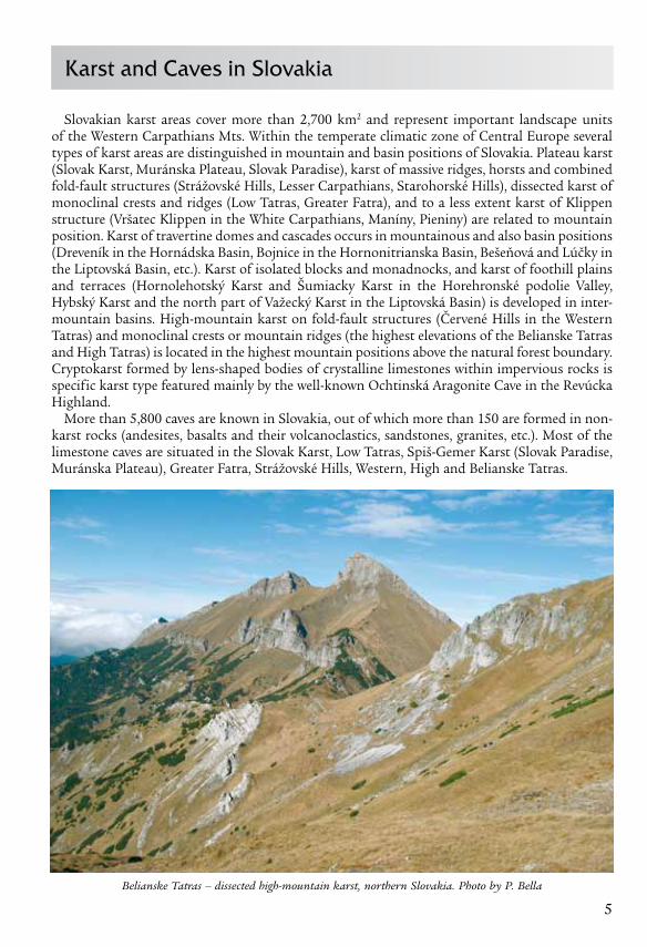
Slovakian karst areas cover more than 2,700 km2 and represent important landscape units of the Western Carpathians Mts. Within the temperate climatic zone of Central Europe several types of karst areas are distinguished in mountain and basin positions of Slovakia. Plateau karst (Slovak Karst, Muránska Plateau, Slovak Paradise), karst of massive ridges, horsts and combined fold-fault structures (Strážovské Hills, Lesser Carpathians, Starohorské Hills), dissected karst of monoclinal crests and ridges (Low Tatras, Greater Fatra), and to a less extent karst of Klippen structure (Vršatec Klippen in the White Carpathians, Maníny, Pieniny) are related to mountain position. Karst of travertine domes and cascades occurs in mountainous and also basin positions (Dreveník in the Hornádska Basin, Bojnice in the Hornonitrianska Basin, Bešeňová and Lúčky in the Liptovská Basin, etc.). Karst of isolated blocks and monadnocks, and karst of foothill plains and terraces (Hornolehotský Karst and Šumiacky Karst in the Horehronské podolie Valley, Hybský Karst and the north part of Važecký Karst in the Liptovská Basin) is developed in inter-mountain basins. High-mountain karst on fold-fault structures (Červené Hills in the Western Tatras) and monoclinal crests or mountain ridges (the highest elevations of the Belianske Tatras and High Tatras) is located in the highest mountain positions above the natural forest boundary. Cryptokarst formed by lens-shaped bodies of crystalline limestones within impervious rocks is specific karst type featured mainly by the well-known Ochtinská Aragonite Cave in the Revúcka Highland.
More than 5,800 caves are known in Slovakia, out of which more than 150 are formed in non-karst rocks (andesites, basalts and their volcanoclastics, sandstones, granites, etc.). Most of the limestone caves are situated in the Slovak Karst, Low Tatras, Spiš-Gemer Karst (Slovak Paradise, Muránska Plateau), Greater Fatra, Strážovské Hills, Western, High and Belianske Tatras.
Belianske Tatras – dissected high-mountain karst, northern Slovakia. Photo by P. Bella
6
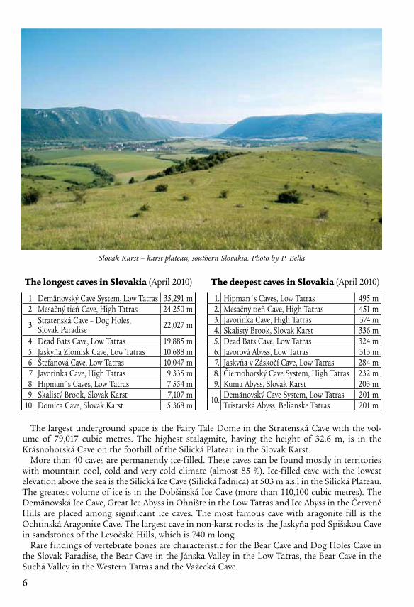
The largest underground space is the Fairy Tale Dome in the Stratenská Cave with the vol-ume of 79,017 cubic metres. The highest stalagmite, having the height of 32.6 m, is in the Krásnohorská Cave on the foothill of the Silická Plateau in the Slovak Karst.
More than 40 caves are permanently ice-filled. These caves can be found mostly in territories with mountain cool, cold and very cold climate (almost 85 %). Ice-filled cave with the lowest elevation above the sea is the Silická Ice Cave (Silická ľadnica) at 503 m a.s.l in the Silická Plateau. The greatest volume of ice is in the Dobšinská Ice Cave (more than 110,100 cubic metres). The Demänovská Ice Cave, Great Ice Abyss in Ohnište in the Low Tatras and Ice Abyss in the Červené Hills are placed among significant ice caves. The most famous cave with aragonite fill is the Ochtinská Aragonite Cave. The largest cave in non-karst rocks is the Jaskyňa pod Spišskou Cave in sandstones of the Levočské Hills, which is 740 m long.
Rare findings of vertebrate bones are characteristic for the Bear Cave and Dog Holes Cave in the Slovak Paradise, the Bear Cave in the Jánska Valley in the Low Tatras, the Bear Cave in the Suchá Valley in the Western Tatras and the Važecká Cave.
1. Demänovský Cave System, Low Tatras 35,291 m2. Mesačný tieň Cave, High Tatras 24,250 m
3. Stratenská Cave – Dog Holes,Slovak Paradise 22,027 m
4. Dead Bats Cave, Low Tatras 19,885 m5. Jaskyňa Zlomísk Cave, Low Tatras 10,688 m6. Štefanová Cave, Low Tatras 10,047 m7. Javorinka Cave, High Tatras 9,335 m8. Hipman´s Caves, Low Tatras 7,554 m9. Skalistý Brook, Slovak Karst 7,107 m
10. Domica Cave, Slovak Karst 5,368 m
The longest caves in Slovakia (April 2010) The deepest caves in Slovakia (April 2010)
1. Hipman´s Caves, Low Tatras 495 m2. Mesačný tieň Cave, High Tatras 451 m3. Javorinka Cave, High Tatras 374 m4. Skalistý Brook, Slovak Karst 336 m5. Dead Bats Cave, Low Tatras 324 m6. Javorová Abyss, Low Tatras 313 m7. Jaskyňa v Záskočí Cave, Low Tatras 284 m8. Čiernohorský Cave System, High Tatras 232 m9. Kunia Abyss, Slovak Karst 203 m
10. Demänovský Cave System, Low Tatras 201 m Tristarská Abyss, Belianske Tatras 201 m
Slovak Karst – karst plateau, southern Slovakia. Photo by P. Bella

7
The Ardovská Cave, Domica Cave, Majda-Hraškova Cave, the Kostrová Cave (Slovak Paradise), Prepoštská Cave (Hornonitrianska Basin), Čertova pec Cave (Považský Inovec Mts.) and Deravá skala Cave (Lesser Carpathians) are known as important archaeological sites. Remarkable inscriptions have been preserved on the walls of Jasovská Cave and several other caves. During the World War II many caves served as shelters.
According to the Act of the National Council of Slovak Republic on Nature and Landscape Protection from 2002, all the caves are considered nature monuments. Caves are designated state property according to the Constitution of the Slovak Republic. Forty four caves and abysses have been designated national nature monuments based on their geomorphic values, occurrence of unique speleothems or ice, palaeontological and archaeological findings as well as historical memorabilia.
On the basis of bilateral Slovak-Hungarian project, the caves of the Slovak and Aggtelek Karst were inscribed on the World Natural Heritage List in December 1995. In
2000 this project was extended by the Dobšinská Ice Cave with the whole genetic system of Stratená Cave. The Domica Cave was included on the List of Internationally Important Wetlands within the Ramsar Convention on Wetlands in 2001, the Caves of the Demänovská Valley in 2006.
The headquarters of the Slovak Caves Administration is in the town of Liptovský Mikuláš, where also the specialised Slovak Museum of Nature Protection and Speleology and the Slovak Speleological Society is located.
Show caves Twelve show caves – Belianska Cave, Bystrianska Cave, Demänovská Cave of Liberty,
Demänovská Ice Cave, Dobšinská Ice Cave, Domica Cave, Driny Cave, Gombasecká Cave, Harmanecká Cave, Jasovská Cave, Ochtinská Aragonite Cave and Važecká Cave are man-aged by the Slovak Caves Administration as a special section of the State Nature Conservancy of the Slovak Republic. Other show caves include the Bojnická Castle Cave – within the castle tour, and caves opened for tourists in more natural way – Dead Bats Cave, Krásnohorská Cave, Zlá diera Cave and Malá Stanišovská Cave. Prepoštská Cave is opened for visitors as an archaeolog-ical exposition in nature and Morské Oko Cave is an arte-sian well abyss opened to approach from the f loating pier (the cave itself is acces-sible for cave divers only).
Gombasecká Cave – well-known by straw stalactites, Slovak Karst. Photo by P. Bella
Board of the World Heritage in the Dobšinská Ice Cave, Slovak Paradise.
Photo by P. Bella
8
Congress Venue and Surrounding
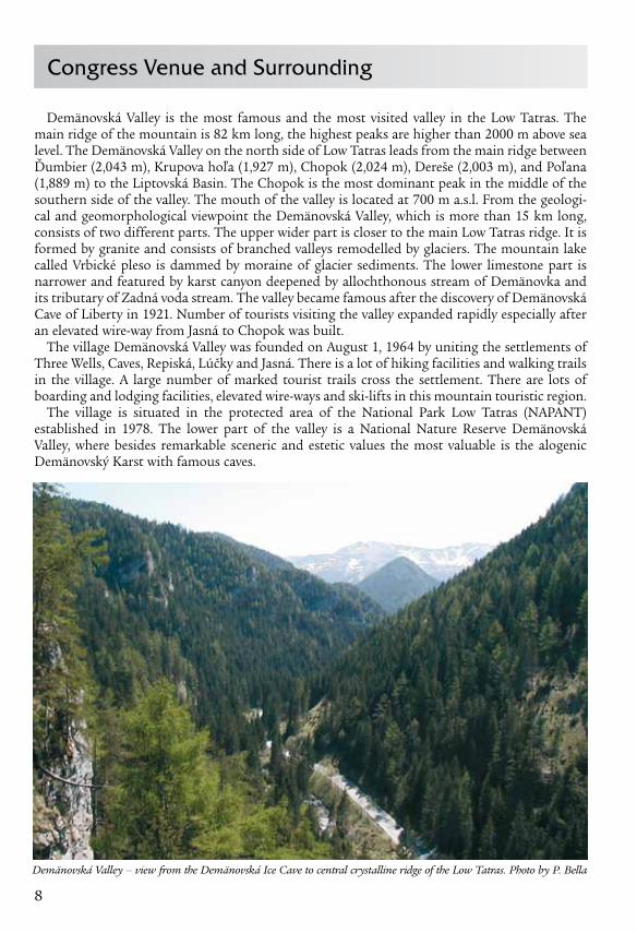
Demänovská Valley is the most famous and the most visited valley in the Low Tatras. The main ridge of the mountain is 82 km long, the highest peaks are higher than 2000 m above sea level. The Demänovská Valley on the north side of Low Tatras leads from the main ridge between Ďumbier (2,043 m), Krupova hoľa (1,927 m), Chopok (2,024 m), Dereše (2,003 m), and Poľana (1,889 m) to the Liptovská Basin. The Chopok is the most dominant peak in the middle of the southern side of the valley. The mouth of the valley is located at 700 m a.s.l. From the geologi-cal and geomorphological viewpoint the Demänovská Valley, which is more than 15 km long, consists of two different parts. The upper wider part is closer to the main Low Tatras ridge. It is formed by granite and consists of branched valleys remodelled by glaciers. The mountain lake called Vrbické pleso is dammed by moraine of glacier sediments. The lower limestone part is narrower and featured by karst canyon deepened by allochthonous stream of Demänovka and its tributary of Zadná voda stream. The valley became famous after the discovery of Demänovská Cave of Liberty in 1921. Number of tourists visiting the valley expanded rapidly especially after an elevated wire-way from Jasná to Chopok was built.
The village Demänovská Valley was founded on August 1, 1964 by uniting the settlements of Three Wells, Caves, Repiská, Lúčky and Jasná. There is a lot of hiking facilities and walking trails in the village. A large number of marked tourist trails cross the settlement. There are lots of boarding and lodging facilities, elevated wire-ways and ski-lifts in this mountain touristic region.
The village is situated in the protected area of the National Park Low Tatras (NAPANT) established in 1978. The lower part of the valley is a Natio nal Nature Reserve Demänovská Valley, where besides remarkable sceneric and estetic values the most valuable is the alogenic Demänovský Karst with famous caves.
Demänovská Valley – view from the Demänovská Ice Cave to central crystalline ridge of the Low Tatras. Photo by P. Bella

9
Karst and caves of the Demänovská Valley
The karst of the De- mänovská Valley on the northern slope of Nízke Tatry Mts. (Northern Slo-vakia) in Middle Triassic Gutenstein Lime stones of the Krížna Nappe pre-sents a contact dissected karst of monoclinal crests and ridges in the middle-mountain positions of the Western Carpathians Mts. Prevailing karst features in this dissected mountain area relate to subsurface phenomena. The domi-nant multi-leveled cave system on right side of the valley, which is more than 35 km long (the long-est cave in Slovakia), was formed mainly by sinking allochthonous streams at nine levels. The highest cave level IX is located 140 m above the recent stream flowing through the bottom of valley. The development of cave levels is correlated with the devel-opment of river terraces on the surface in the north part of the valley and the adjacent part of Liptovská Basin. However, the whole cave system is not mor-phologically homogenous. At the contact non-kars-tic and karstic area, seve-ral drawdown vadose pas-sages lead from sinkholes or invasion sinkholes to a lower levelled river bed of main underground stream.
Demänovský Cave System consists of the Demänovská Cave of Liberty, Demänovská Cave
Cav
es a
nd t
heir
dev
elop
men
tal l
evel
s in
the
Dem
änov
ská
Valle
y (a
fter
Dro
ppa,
197
2)

10
of Peace, Demänovská Ice Cave, Pustá Cave, Vyvieranie Cave, Jaskyňa trosiek Cave, Údolná Cave, Jaskyňa pod útesom Cave and other smaller caves (Demänovská Cave of Liberty and Demänovská Ice Cave are opened to the public). More than 200 caves of several genetic types are known in the Demänovská Valley. Besides of river caves originated by corrosion and erosion of allochthonous or autochthonous streams also several crevice caves originated by gravity slope disintegration, caves modelated by corrosion of seeping atmospheric waters, and small caves formed by frost weathering occur in the karst area of middle-mountain position dissected by allochtonous stream valley. From the caves of Demänovská Valley active and inactive allochtonous river caves are the longest and most significant.
Miraculous Halls, Demänovská Cave of Liberty. Photo by P. Bella
Zbojnícka Cave – VIIth cave developmental level in the Demänovská Valley. Photo by P. Staník

11
PODNADPISGeneral Programme
October 15 – 17, 2010Pre-congress excursion – Czech Republic: Prague, Koněpruské Caves, Na Turoldu Cave, Moravian Karst (Sloupsko-Šošůvské Caves, Výpustek Cave, Punkevní Caves, Macocha Abyss), Zbrašovské Aragonite Caves
October 17, 2010Arrival to congress venue and registration
October 18, 201008:30 – 09:00 Official opening 09:00 – 10:30 General Assembly, part I11:00 – 12:30 Around the World14:30 – 15:50 Papers Session I16:00 – 19:30 Opening Ceremony – Demänovská Cave of Liberty
October 19, 201008:30 – 10:30 Papers Session II11:00 – 13:00 Papers Session III15:00 – 19:00 Excursion – Demänovská Ice Cave19:00 – 20:00 Submission of the Nominating Committee
October 20, 201008:15 – 20:00 Excursion – Dobšinská Ice Cave, Spišský Castle
October 21, 201008:30 – 10:30 General Assembly, part II / Election of the Board of Directors11:30 – 11:45 Presentation of applicants to host the 7th Congress of ISCA in 201411:45 – 12:30 New ISCA website14:30 – 16:00 Papers Session IV16:30 – 20:00 Excursion – Pribylina Open Air Museum
October 22, 201008:30 – 10:30 Papers Session V11:00 – 13:00 Papers Session VI15:00 – 16:20 Papers Session VII16:20 – 17:00 Presentation of posters17:30 – 18:45 Selection of next venues – 7th ISCA Congress 2014, ISCA Conference 201218:45 – 19:00 Presentation of 16th International Congress of Speleology 2013 Brno, Czech Republic20:00 Closing Ceremony
October 23, 201008:30 – 20:30 Excursion – Ochtinská Aragonite Cave, Domica Cave
October 24 – 25, 2010Pre-congress excursion – Hungary: Aggtelek National Park, Baradla Cave, Rákóczi Cave, Vass Imre Cave, Béke Cave, Kossuth Cave

12
Abstracts
RadIatIoN PRoteCtIoN agaINSt RadoN IN NatuRal CaveS of tHe Slovak RePuBlIC
Pavol adámek, alžbeta durecová
Regional Authority of Public Health, Radiation Protection Department, Cesta k nemocnici 1, 975 56 Banská Bystrica, Slovak Republic
The radioactive noble gas radon and its decay products can be a significant source of exposure to natural radiation in natural caves. In May 2006, legislation (regulation No. 345/2006 on the basic safety standards requirements for protection of workers and public against ionizing radia-tion) was introduced to limit, inter alia, the exposure of workers in the Slovak Republic to radon. The legislation specifies an average Reference level of 400 Bq/m3 and an average Action level of 1000 Bq/m3 for radon in workplaces. Personal monitoring for underground workers is necessary by providing each worker with a radon detector which is worn during the working hours when the average Action level is exceeded more than 1.5 times. A summary of experiences regarding to radiation protection against radon in natural caves will be presented.
NegatIve aNtHRoPogeNIC ImPaCtS oN tHe Cave eNvIRoNmeNt: geoeCologICal aPPRoaCH aNd ImPlICatIoN
foR SHoW CaveS PRoteCtIoN
Pavel Bella
State Nature Conservancy of the Slovak Republic, Slovak Caves Administration, Hodžova 11, 031 01 Liptovský Mikuláš, Slovakia; [email protected]
Caves as valuable or rare natural sites present specific geoecological systems with several pecu-liar features of underground environment. Mainly in karst areas cave geosystems have stronger connections with surface landscape systems. Many caves are influenced and disturbed by several negative anthropogenic impacts. Usually they are analyzed according to types of human activities and subsintent negative impacts, their primary or secondary influences on the cave environment and the location of their sources or causations inside or outside of the cave. From the geoecological point of view basic categories of negative anthropogenic impacts are distinguished according to their influences to natural components and a functional mechanism cave geosystems: (1) negative anthropogenic impacts cause the destroying of cave or its part by removal of host-rocks (e. g. caves destroyed by excavation of raw material); (2) negative anthropogenic impacts cause the interrup-tion or destroying of one or several components of cave geosystems – without or with inexpressive interferences on the functional mechanism of cave geosystems (e. g. destroying of speleothems, dirtying of caves, nowider covering of cave floor by ferroconcrete pathway for visitors); (3) nega-tive anthropogenic impacts interfere on the functional mechanism of cave geosystems: (3a) nega-tive anthropogenic impacts cause the interruption or change of cave geosystem behavior that are related to reversible changes given and limited by self-regulation of cave geosystems and threshold values of their loading (e. g. equalization and compensation of speleoclimatic changes in conse-quence of visitors´ movement in show caves, temperature and photic changes near electric lights in show caves), irreversible changes cause the transformation of geosystem to a different stability
13
state (e. g. large number of visitors and electric lighting in show caves, excessive contamination of ground waters by agricultural or industrial activities) and anthropogenic changes of etocycles of cave geosystems (e. g. changed regime of dripping waters caused by deforestation on the surface above the cave, repeated floods after deforestation or disproportionate agricultural land-use in the catchment area with a soil erosion, air movement changed by opening of new cave entrances, decelerated velocity of stream and accelerated accumulation of fluvial sediments in several river beds after building of artificial dams in caves); (3b) negative anthropogenic impacts cause the change of succesional dynamics of cave geosystems (invariant changes of cave geosystems related to the changed drainage of phreatic or epiphreatic cave in connection with a decrease of water table caused by digging of drain tunnels, the flood of vadose cave in consequence of an increase of water table caused by building of artificial dam, changed speleoclimatic processes in ice-filled cave in consequence of artificial opening of new entrances or siphons leading to other cave parts); (4) negative anthropogenic impacts caused both the interruption or destroying of one or several components of cave geosystems and interference on the functional mechanism of cave geosystems. Geoecological knowledge on cave environment changes caused by negative anthropogenic impacts are needed and useful for cave environmental protection measures.
datINg of PRoCeSSeS IN kaRSt aNd CaveS: ImPlICatIoN foR SHoW CaveS PReSeNtatIoN
Pavel Bosák
Institute of Geology AS CR, v. v. i., Academy of Sciences of the Czech Republic, Rozvojová 269, 165 00 Praha 6 – Lysolaje, Czech Republic; [email protected]
Karst Research Institute, Scientific Research Center, Slovenian Academy of Sciences and Arts, Titov trg 2, 6230 Postojna, Slovenia
Determining the beginning and the end of the life of a karst and cave system is a substantial problem. In contrast to most of living systems, the development of a karst system can be “frozen” and then rejuvenated several times, i. e. it can has polycyclic and polygenetic nature. The principal problems may include precise definition of the beginning of karstification (e. g. inception in spe-leogenesis) and the manner of preservation of the products of karstification. Karst evolution is particularly dependent upon the time available for process evolution and on the geographical and geological conditions of the exposure of the rock. The longer the time, the higher the hydraulic gradient and the larger the amount of solvent water entering the karst system, the more evolved is the karst. The end of karstification can be viewed from various perspectives. The final end occurs at the moment when the host rock together with its karst phenomena is completely eroded/denuded. In such cases, nothing remains to be dated. Karst forms of individual evolution stages can also be destroyed by erosion, denudation and abrasion without the necessity of the destruction of the whole sequence of karst rocks. Temporary (e. g. filling by cave sediments) and/or final (fossilization s. s.) interruption of the karstification process can be caused by the fossilisation of karst due to loss of its hydrological function. Such fossilisation can be caused by metamorphism, mineralisation, marine transgressions, burial by continental deposits or volcanic products, tectonic movements, climatic change etc. The introduction of new energy (hydraulic head) to the system may cause reactivation of karstification reflected in the polycyclic and polygenetic nature of karst formation.
Karst sediments are a special kind of geologic materials, which resulted also from polycyclicity of processes. The dynamic nature of karst can lead to re-deposition and reworking of classical stratigraphic order. Those processes can make the karst record unreadable and problematic for interpretation. The karst environment favors both the preservation of paleontological remains and their destruction. On one hand, karst is well known for its wealth of paleontological sites,

14
but most cave fills are completely sterile on the other hand. The role of preservation is very important because karstlands function as traps or preservers of the geologic and environmental past, especially of terrestrial (continental) history where correlative sediments are mostly miss-ing, but they carry also marine records.
The fills of exokarst landforms (especially some epikarst forms) offer more possibilities for the preservation of fossil fauna and flora than do cave interiors. Paleontological finds are rare in interior cave sediments, where phreatic conditions prevail (in main channels the remains are destroyed by gravel and in side passages with slow currents only fine sediments can be deposit-ed). Troglobitic fauna and flora are usually much too small in number and volume to be signifi-cant. Therefore, fossil remains within a cave, that come from the surface (carried in by sinking rivers) or from trogloxenes (e. g. cave-using bats, some birds and mammals), are more important. Airborne grains (pollen, volcanic ash) can only be important when favorable air-circulation pat-terns are developed within a cave. Nevertheless, cave sediments, especially far from the ponor or other entrance, tend to be highly depleted in fossil fauna and/or the preservation of the fossils is too poor for precise determinations.
It is generally known that fossils will be preserved mostly in the upper parts of a sedimentary fill and/or in entrance cave facies, and the time ranges of most absolute dating methods applica-ble to karst deposits is relatively short. Some fossils in such cave facies can have been re-deposited by the erosion of older sediments and/or derived from collapsed near-surface (epikarst) fills of greater age or represent only fragmental and poorly preserved material. Paleontological remains which were deposited in entrance parts or in shallow caves are destroyed by the denudation in relatively short time together with the caves they were deposited in. Because of that reason the faunal remains of the cave entrance facies can not be very old.
The cave environment can be divided from the sedimentological point of view into an entrance facies and an interior facies. The entrance facies is developed in the front of cave opening, in cave entrance and in entrance part of the cave, more o less in the photic zone. The principal processes, which take part in the formation of the entrance facies is slope retreat and unroofing causing the cave shortening. It includes fine-grained sediments transported from the vicinity of the cave by wind and water and coarser clasts transported into the cave by slope processes. The entrance facies represents the most valuable section of the cave from a stratigraphic point of view. The cave entrance contains pollen as well as datable archaeological and paleontological remains that are protected from surface erosion, weathering and biochemical alteration. Fauna remains (both bones and coproliths) occur as thanatocenoses (rests of animal, which died on place) and tapho-cenoses (rest of animals brought by carnivors). The disadvantage of the entrance facies is (1) the small volume and (2) continuous slope retreat shifting depocentre inside the former cave. Both factors do not enable the deposition and preservation of thicker sedimentary complexes. The results in relatively short stratigraphic record captured in the entrance facies in caves and rock shelters; in the Central Europe mostly only the Last Glacial up to Holocene.
The interior facies develops in those parts of the cave that are more remote from the surface. Sedimentary sequences here can be extensive, consisting of fluvial gravels and sands overlain by flood or injecta deposits of laminar silts and clays often intercalated by speleothems. They can also contain dejecta, colluvial material and outer clastic sediments (including marine ones) often re-deposited and/or injected for longer distances within the cave. They form in vadose conditions. Due to the dynamic environment of cave interiors and periodicity of events, sedimentary sequences often represent a series of depositional and erosional events (sedimentary cycles). They are sepa-rated by unconformities (breaks in deposition), in which substantial time-spans can be hidden. The erosional phases can be much longer that depositional events, which can represent single-flood episodes. Relics of phreatic silts and clays are relatively rare and they typically contain no fossils.
The stratigraphic order in sedimentary sequences is usually governed by the law of superposi-tion, according to which the overlying bed is younger than the underlying one under normal tectonic settings. The law is valid for the majority of sedimentary sequences. However, river ter-
15
races and karst environment may present exceptions. The succession of processes connected with entrenchment of river systems cause higher levels of sediments to be older than lower ones. Karst, owing to its dynamic nature, polycyclic and polygenetic character carries some other thresholds – the karst records can be damaged by the simple process of erosion and re-deposition. The reacti-vation of karst processes often mixes karst fill of different ages (collapses, vertical re-depositions in both directions, etc.). Contamination of younger deposits by re-deposited fossil-bearing sedi-ments has been known elsewhere in caves. Well-known are also sandwich structures: younger beds are inserted into voids in older ones. Those processes degrade the record in karst archives.
The final accumulation phase has been dated in caves in most cases, i. e. when the cave is in a quasi-stationary state because the input of energy (water) has been interrupted, detaching the cave from the local hydrological regime for different reasons and for highly differing time-spans; the cave becomes fossilized, at least temporarily. The temporary fossilization of the cave (i. e. fill by cave sediments) and rejuvenation (excavation of sediments) mostly reflect changes in the resurgence area, especially vertical change (in both directions) of base level at the karst springs. The rejuvenation of the karst process can excavate the previous cave fill/fills completely, which is the most common case resulting from the polycyclic nature and dynamics of cave environments. Under favorable settings, fills belonging to more infill phases (cycles) separated by distinct hiatuses (unconformities) can occur in one sedimentary profile. Such amalgamation is typical especially in ponor (sinkhole) parts of the cave.
Owing to the fact that unmetamorphosed or only slightly metamorphosed karst rocks con-taining karst and caves have occurred since Archean, we can apply a wide range of geochrono-logic methods. Most established dating methods can be utilised for direct and/or indirect dating of karst and paleokarst. The karst/paleokarst fills are very varied in composition, including a wide range of clastic and chemogenic sediments, products of surface and subsurface volcanism (lava, volcaniclastic materials, tephra), and deep-seated processes (hydrothermal activity, etc). Stages of evolution can also be based on dating correlated sediments that do not fill karst voids directly. The application of individual dating methods depends on their time ranges: the older the subject of study, the more limited is the choice of method. For dating clastic cave sediments and speleothems it is limited by the complex conditions occurring underground so that it is often necessary to combine different methods that offer supplementary absolute-, calibrate-, relative- or correlate-ages.
The results of scientific research represent important and powerful tool also for management of show caves. Results of any kind of dating of processes and products show the integrity of caves in evolution of landscape. Public can be more easy learned about evolution stages of karst land-scape, cave and cave systems, their fills, about protection and conservation issues. Time aspect in formation of caves and their fills documented by dating methods represents valuable and highly attractive information for broad public, which can be presented in official show cave materials, leaflets, web pages, etc. Project IAA 300130701.
modeRN led dyNamIC lIgHtINg SyStem aNd INtegRa-tIoN lIgHt muSIC SHoW IN CoNtRol SyStem of SHoW Cave:
tSkaltuBo/kumIStavI Cave, geoRgIa
alexander Chrapko
GermTec GmbH & Co. KG, Hohe Strasse 700 Geb. 5B, 35745 Herborn, Germany
The paper presents specific properties and opportunities of the “Cave Lighting” dynamic sys-tem and different possibilities of the integration in system multimedia solutions. The main goal of the project in Georgia is the development, installation and adjustment the electrical equip-

16
ment for the interior illumination for new show-cave “Tskaltubo Cave”. The project consists of following parts: (1) “Cave LightingTM” LED lights illumination system; (2) Audio and music illustration system; (3) Emergency power and lighting system; (4) Alarm and monitoring system; (5) Communication phone system.
The total length of the visitor area of the cave is 1200 m. The cave has 15 halls. The inner space of cave divided into 7 electrical zones. Each electrical zone has Power Box which provides power for 2 or 3 halls. Each hall has separate and logically independent lighting system. The Control Centre is the service room at the building where located electrical equipment and where situated the duty supervisor of the cave.
The advantages of the LEDs: – High luminous efficiency – the relation is 95 % of light to 5 % of heat generation. For the
standard lamps, especially the halogen ones, this relation is diametrically opposite.– Long service life. According to the data of the producing companies, the service life of an
LED in ideal conditions can reach approximately 100,000 hours. But in reality there are no ideal conditions. Thus, we proceed from the assumption that an LED service life under favorable circumstances would be about 50,000 hours. But even if this time would be reduced to 25,000 hours we could count upon approximately 12 years of the service life of the LED devices.
– Systems based on the LED technologies work in a low-voltage range. In Germany, for example, they can be used without any additional permission. There are also no particular official regulations concerning them. The LED systems can be characterized by the high economical efficiency and low energy consumption.
– The luminous flux of the LEDs is regulated electronically. So the LED systems are flexible “organisms”. The system structure gives the opportunity to create various special effects and light profiles.
– As a rule, LED devices are characterized by a high degree of reliability. They are not sensitive towards vibrations and are shock resistant.
– The luminous spectrum used in the LED devices is outside the spectrum of the ultraviolet radiation, which allows us to speak about the so-called ecological light. The “Cave LightingTM” LED light fixtures is a luminary specially designed for lighting applica-
tions at show caves and other outdoor solutions for a hard natural conditions. This offers total flexibility by offering control systems with a variety of optical beam angles. The LED is designed for outdoor installations enclosed in a unique housing and complete with High power LED light source. Internal power source regulation provides stable light output of LED. The cable provides interconnect to the any type of power connection. Adjustable side mounting bolts offer full flex-ibility for the installation position of this luminary.
tHe PRoBlem of lamPeNfloRa IN SHoW CaveS
arrigo a. Cigna
Chairman of the ISCA Scientific and Technical CommitteeFraz. Tuffo, Str. Bottino 2, I-14023 Cocconato (AT), Italy
Lampenflora is typical problem of show caves, because the light that is necessary for the visi-tors supplies enough energy to some plants, mainly algae and mosses, which may grow to the point of defacing and damaging seriously the cave itself. After a description of the main charac-teristics of lampenflora and a detailed list of the environmental conditions contributing to its development, the best methodology to control such a development with particular attention to an easy and successful implementation is here described.

17
tHe eSSeNtIal Role of INteRPRetIve guIdINg IN eNSuRINg uNdeRStaNdINg aNd CoNSeRvatIoN
of Cave aNd kaRSt SyStemS
dan Cove
Manager Cave Operations, Jenolan Caves, Australia
It is an unfortunate reality that an automatic love of the natural world and a desire to see it protected is not instinctive to the majority of individuals. This does not suggest that the majori-ty of the population are malicious or desirous of causing harm to the environment, rather that there is no instinctive appreciation of the fragility of one’s surrounds and the ease with which they may be irrevocably altered and damaged. Such an appreciation may be reached and indeed it often proves very easy to cultivate. However recognising this need to educate and foster unders-tanding and appreciation in individuals does place an onus on the managers, custodians and guides of significant sites. Any commitment to conservation requires public support, and this support requires a public that feels a connection to the values of the environment in question. One extremely effective means of achieving this is through well planned and delivered interpre-tive guiding, and highly trained guides.
The importance of interpretive guiding is of special relevance to cave management, as geodi-versity has a generally lower popular perception of potential fragility than does biodiversity. A geological site may be seen as a far less renewable natural resource that a biological site because of the time involved in its formation processes. Visitors to limestone caves are often genuinely surprised when asked to refrain from touching calcite formations, as the concept that a person touching a rock is damaging can be a very difficult one to grasp.
Training of guides, and delivery of a coordinated and structured interpretive tour experience are of an importance once overlooked. It is inadequate to recruit a new guide, present them with the necessary facts and figures and expect them to translate these into a meaningful experience for visitors. The on-site experience can be the single greatest factor in establishing a long-term connection to both the site and the broader associated environment and therefore the quality of the guide and the guided experience are of enormous importance.
PRelImINaRy PRoPoSal foR tHe PRojeCt of adaPtINg “HeaveN’S Cave” (vIetNam) foR touRISt PuRPoSeS
Bogdan debevc1, martin knez2, andrej kranjc2, mitja Prelovšek2, aleš Semeja3, tadej Slabe2
1 Tourism Kras, Jamska 30, SI-6230 Postojna, Slovenia2 Karst Research Institute, Scientific Research Center of the Slovenian Academy of Sciences and Arts,
P.O.Box 59, SI-6230 Postojna, Slovenia3 Sava Group, Tourism, Škofjeloška 6, SI-4000 Kranj, Slovenia
The cave is located at the edge of the Nha-Ke Bang natural reserve, 40 km from the city of Dong Hoi. This natural reserve is protected as a UNESCO site. Because the cave is a sensitive ecosystem, we must provide for the following arrangements in connection with the execution of the project: all required measurements and surveys in the cave, obtain any building permits required for carrying out work in the protected natural reserve, adaptation of external infrastructure, the preliminary proposal for the tourist route and the arhitectual design work.
18
ReCeNt kNoWledge aNd utIlIzatIoN of tHe kaRSt CaveS foR SPeleotHeRaPy
Svetozár dluholucký
SVEJAN- Speleo, v. o. s., 2nd Department of Pediatrics, Slovak Medical University & Children Faculty Hospital, Banská Bystrica, Slovakia
The benefitial effect of the karst cave environment to human health has been known since last history and was used as a natural medicine in various parts of the world. Modern speleotherapy and extensive research during the last decades of 20th century brings many new findings not only in field of the human health. The benefitial effect of speleotherapy to the respiratory tract disor-ders has been confirmed in adults and children. The substantial improvement was registered in the clinical, functional and immunological parameters of the chronic and allergic (asthmatic) disorders. Attained effect was long-standing, and even recovery was registered in children. Except the mentioned diseases the benefit was recorded on locomotory apparatus (possible effect to osteoporosis), skin (ekcema and cosmetic effect), and global psychosomatic efficiency. The paral-lel study od cave microclima reveal many factors responsing for the mentioned effect. Except the physical characteristics, many biogenic elements, low-treshold radiation, and ionisation of the cave aerosol are unique. Microbial sterility and absence of the dust particles are not attainable in another – arteficial conditions. The long-term follow.up revealed unexpected stability and self-regeneration of cave microklima. Any variation due to the entrance of people is immediatelly returned to normal after people leaving the cave. All presented results and parameters help us to undertand and to safe use of karst caves for the humans and help us for their better proto-tecion. Many new discoveries enrich our knowledge in the field of biophysiology, immunology and climatology.
model of develoPINg ComPeteNCeS of tHe SHoW Cave guIdeS aNd a SyStem of PeRmaNeNt meNtoRSHIP/tutoRINg/
tRaININg (PoStojNSka jama, SloveNIa)
ksenija dvorščak
Turizem KRAS d. d., Jamska cesta 30, SI-6230 Postojna, Slovenia
At the Postojna Cave there are approximately 25 permanent cave guides, whereas during the main season (from May until the end of October) 70 of them are employed temporarily. Most of them are students. While tourism is a highly labour-intensive sector, a high level of competence development is one of the key success factors. A very important component part of the competence model is skills management, guide training, which has been imple-mented in the company through a system of permanent mentorship in the guide service, where there are a large number of seasonal workers.

19
WISkI 7 – a WoRld WIde uSed eNvIRoNmeNtal moNItoRINg SyStem
Robert gal
KISTERS AG, Charlottenburger Allee 5, 52068 Aachen, Germany
WISKI 7 is the latest version of a, since now more than 20 years experienced information management system, that provides modern tools for advanced analysis of environmental moni-toring data. It is based on the KISTERS Time Series Management core solution, which brings together solutions for all actual requirements of modern environmental monitoring with its quantitative and qualitative parameters. The modular system includes data acquisition, storage management, data analysis and computation, data exchange, data presentation including spatial projection, web publishing and alarm management.
PRoPoSta dI CReazIoNe dI uNa Rete PeR la PRomozIoNe e la PRotezIoNe dI gRotte ad INteReSSe aRCHeologICo
e PaleoNtologICo dell’ISola dI CReta
vassilis giannopoulos, evangelos kambouroglou, Chryssanthi kontaxi
Ministry of Culture, Athens, Greece
L’obiettivo di questa proposta ha doppia valenza:– Permette di proteggere le grotte in relazione al posto in cui si trovano, alla morfologia e
all’interesse relativo alla grotta stessa.– Questa rete può dare ai visitatori una nozione più completa per le grotte stesse ed in genere
per lo speleo turismo. Per questo programma abiamo proposto otto grotte nell’isola di Creta, scelta per i seguenti
motivi: – Si tratta di un isola (quindi un sistema chiuso) ed è la terza più grande del mediterraneo che
riceve piu di un milione di visitatori l’anno con una permanenza media di soggiorno di sette giorni
– Vi si trovano oltre seimila grotte interessanti dal punto di vista speleologico fra le quali, alcune suscitano interesse archeologico e paleontologico.Le grotte sono scelte non solo in base all’interesse che presentano, ma anche in base alla
località in cui si trovano. Così abbiamo scelto tre grotte, già turistiche: Grotta di Sentoni di Zoniana, Grotta di Melidoni, Grotta di Dicteo Andro. Quattro perché conosciute per il loro interesse archeologico; non sono turistiche ma ricevono un numero notevole di visitatori: Grotta di Ideo Andro, Grotta di Milatos, Grotta di Pelekita, Grotta di Kamaroni. Per finire abbiamo scelto una grotta con interesse paleontologico il cui ingresso si trova oggi sotto il livello marino.

20
PRelImINaRy ReSultS of lamPeNfloRa Removal uSINg a 15 % BuffeRed HydRogeN PeRoxIde SolutIoN IN SHoW CaveS
(PoStojNSka jama, SloveNIa)
Stanislav glažar1, janez mulec2
1 Turizem KRAS d. d., Jamska cesta 30, SI-6230 Postojna, Slovenia2 Karst Research Institute, Scientific Research Centre of the Slovenian Academy of Sciences and Arts,
Titov trg 2, SI-6230 Postojna, Slovenia
Phototrophic organisms do not normally grow in light-deprived underground, only excepti-onally as green patches called lampenflora in the illuminated parts of underground passages (caves, mines). The diversity of these organisms in the community is not large; however, they can range from single-cell cyanobacteria to higher plants. Postojnska jama is a world-famous show cave with electric illumination first installed in 1884. Due to large numbers of visitors (approximately 500,000 annually) and a relatively long illumination time (approximately 1000 hrs/sector/year) in the tourist part of the cave, lampenflora represents a serious problem for speleothems and other objects of cultural value, e. g. historic signatures. In the past, lampenflora patches in the cave were regularly (each second year) sprayed with bleach – 5 % NaClO. In 2010, instead of bleach an environmentally-friendly and odour-free 15% solution of buffered hydrogen peroxide – H2O2 (pH 7.5) was applied three times in a one-month period. Once H2O2 is buffered, it becomes unstable, which is why its application on speleothems covered with lampenflora had to be done as soon as possible (< 20 minutes). To increase the biocidal effectiveness and to remove the unaesthetic appearance, taluses of mosses and ferns were removed first, before the application of H2O2. During winter spraying in 2010, the most exposed parts of the cave (~ 30 % of the illuminated cave) were treated as mentioned above and results for the lampenflora growth control are promising. This procedure is especially useful when applied to active growing lam-penflora. Once lampenflora is covered with flowstone, the oxidizing effect of H2O2 is drastically reduced.
HydRologICal aNd HydRogeoCHemICal moNItoRINg of tHe domICa Cave (tHe Slovak kaRSt)
dagmar Haviarová
State Nature Conservancy of the Slovak Republic, Slovak Caves Administration, Hodžova 11, 031 01 Liptovský Mikuláš, Slovakia; [email protected]
The Domica Cave represents 5.4 km long part of the 25 km long cave system Domica-Baradla in a cross boundary position of Slovakia and Hungary. The Domica Cave is located on the south-western edge of the Silica Plateau in the Slovak Karst, near the state border with Hungary. The cave is formed in the Middle Triassic Wetterstein limestones of the Silica Nappe along the tectonic faults by corrosive and erosive activities of Styx Stream and its tributaries. This cave rep-resents one of the 12 show caves in Slovakia, whose management and protection is provided by Slovak Caves Administration. The cave was designated a national nature monument, and a part of the World Natural Heritage site. Domica Cave was declared a Ramsar site – a subterranean wetland of international importance on February 2, 2000.
The main hydrological artery of the system is the intermittent groundwater cave stream Styx with its tributaries. The biggest one is the Domický Brook. The groundwater cave streams are connected with active ponors. Styx flows underground to the Baradla Cave System (Hungary).
21
It springs on the surface in the Hungarian spring near Jósvafő. The activity of Styx is dependent on the precipitation. It becomes active during snowmelt and intensive or longer-term precipita-tion. Its flow fluctuates from 0 – 120 l/s (and more). The increased flows have short duration. The Domický Brook is more sensitive to precipitation. It has bigger maximums as Styx, but its flows have short duration.
The quality of cave water is threatened by several activities within catchment area of the cave (agriculture, soil erosion, illegal waste deposit in dolines, traffic, undisciplined visitors of the cave and national park). In relation to these activities the monitoring of water quality in the cave was realized. Main aim of monitoring was long-term observation of the qualitative and quantitative features of the hydrological cave system, the definition of dynamics and transport of pollution and its elimination or accumulation in the cave system.
First monitoring was realized in the half nineties of the 20th century in the cave. Continually monitored are conductivity and temperature of water and water level since 1999 (project PHARE “Protection of Natural Resources in Karst”). Observations are supplemented with water sampling. New monitoring project, with new equipment (automatic registration station AMS 111 of manufacturer MicroStep – MIS Slovakia, sensors for measuring of water conductivity, temperature of water, pH, water level, new meteorological station) and new method (interval of recording parameters – 10 minutes) started in 2006. Three monitoring places were made in the cave. One of the best advances of the new monitoring system is, except for collection and storing data, also the remote access, control and transfer of data to the headquarters of the Slovak Caves Administration in Liptovský Mikuláš (about 170 km).
The detailed chemical composition of cave water including its quality is evaluated on the basis chemical analyses too (nearly 100 chemical analyses). The old chemical analyses came from the period 1982 – 2006. New water samples and their analyses were realised during the period 2007 – 2010, as a results of the cooperation between Slovak Cave Administration and Department of Hydrogeology of the Faculty of Natural Sciences CU Bratislava.
deteRmININg tHe dePeNdeNCe of Cave mICRoClImate oN exteRNal ClImatIC CoNdItIoNS IN SHoW CaveS
of tHe moRavIaN kaRSt
jiří Hebelka
Cave Administration of the Czech Republic, Cave Administration of the Moravian Karst, Svitavská 11, 678 01 Blansko, Czech Republic; [email protected]
The Moravian Karst is the best-known and most important karst region in the Czech Republic. It is primarily formed of limestone from the middle and late Devonian period to lower Carbiferous. We are aware of more than 1,000 caves here, five of which have been opened to the public. The largest of these caves is the Amateur Cave, which is more than 40 km long.
Detailed knowledge of the microclimatic conditions inside caves provides valuable informa-tion necessary for solving questions concerning protection of caves, their karstification, distri-bution of animal species in caves and also enables us to discover the answers to issues such as specification of visiting rate limits, the number of entries made into caves, etc.
On the basis of a grant received from the Science and Research Program of the Ministry of the Environment, monitoring of microclimatic relations in caves in the Moravian Karst was launched in 2007. Its chief purpose is to determine the dependence of cave microclimate impact on external climatic conditions. The Cave Administration of the Czech Republic is the research organisation in cooperation with the University of Wroclaw and the Czech Hydrometeorological Institute is the co-researcher. The whole five-year project will be completed in 2011.
22
The Katherine Caves, Punkevní Caves and the Sloupsko-šošůvské Caves in the Moravian Karst were chosen for microclimatic measurements. Amateur Cave, which is not open to the public, is also monitored for comparative measurements. Measurements of external climatic conditi-ons is ensured through a network of meteorological stations (Sloup, Macocha, Punkevní Cave, Katherine Caves, Ostrov u Macochy). An automatic stationary monitoring system was installed in the Katherine Cave and Punkevní Cave to monitor microclimatic conditions. This enables continuous monitoring of individual variables with remote transfer of measured values to com-puters. The record interval is 1 minute. The monitoring system is made up of a system of sensors for measuring air temperature and relative air humidity, temperature of the rock formation, water temperature, air flow speed and direction, atmospheric air and carbon dioxide pressure. Changes in air temperature are monitored in the Sloupsko-šošůvské Caves and in the Amateur Cave using temperature sensors, which record measured values.
The preliminary results of monitoring indicate that cave microclimate is affected by the presence of tourists. For instance when visitors pass through a cave the temperature increases temporarily by several tenths of a °C, after they leave the temperature returns to its original value fairly quickly. It is also clear from the monitoring results that changes to air temperature in some parts of the cave, caused by changes in external climatic conditions or as a result of running water, are significantly greater (up to several °C) than changes caused by visitors to the cave.
ClImatIC SyStem of doBšINSká ICe Cave – RelatIoN BetWeeN aIR exCHaNge aNd tHeRmal-HumIdIty
CoNdItIoNS INSIde tHe ICy PaRt of tHe Cave
magdalena korzystka1, jacek Piasecki1, tymoteusz Sawiński1, ján zelinka2
1 Institute of Geography and Regional Development, Department of Meteorology and Climatology, Wrocław University, Plac Uniwersytecki 1, 50-137 Wrocław, Poland
2 State Nature Conservancy of the Slovak Republic, Slovak Caves Administration, Hodžova 11, 031 01 Liptovský Mikuláš, Slovakia
The volume of the ice accumulated in the Dobšinská Ice Cave reaches about 110,000 m3 and it is the greatest ice accumulation of all the ice caves in Slovakia. The ice monolith is the main ice accumulation form of the cave; however, one may find there many others ice speleothems (stalag-mites, stalagnates, draperies as well as many sublimation crystals). Their spatial occurrence and persistence depend on the heat exchange as well as on the moisture transfer in the cave system. The air circulation between the cave system itself and the cave surroundings has a crucial role for all the processes mentioned above – the in-cave temperature during the thermal winter and the in-cave ablation period depend on it.
There are two air circulation types in the Dobšinská Ice Cave: the winter one and the summer one. The winter air circulation type is generated by the cold air in-f low, its time and intensity depend on the differences in the temperatures between the cave and the cave surroundings. It is very important for the overall cave temperature and determines the cave cooling. The situation changes in summer when the air f lows out from the deep and ice-free parts of the (summer “chimney effect” phase) and the air exchange dynamics becomes less intensive (if compared to the winter period). However both, the winter and the summer air circulation types may occur in spring as well as in autumn. The schemes of the air exchange, of the Dobšinská Ice Cave, were evaluated on the six year period of the air f low measurements. The seasonal differences in the air f low are the main factor that influences on the temperature and humidity of the cave air.

23
During the winter flow of the air into the cave, the changes of in-cave thermal conditions correspond to the external air temperature changes (winter type of the air temperature changes) and the rock massif cools down too. Deeper in the cave the air changes its properties; it warms up and becomes water-saturated (sublimation).
Then, in the spring we observe periods when the winter air circulation stops. As a result of this phenomena, the cave temperature increases gradually (spring type of the air temperature changes). This phenomena depends two main factors, one of which is the in-flow of the water saturated air from the ice-free parts of the cave and the second one is the increase in temperature of the rock massif. This is the period with the important thermal gradient between the moist cave air and the cool cave walls in the effect of which the sublimation ice crystals cover arises.
At the beginning of summer the cave air temperature stabilizes and varies from 0 °C to 1 °C (summer type of the air temperature changes) and the cave air is almost saturated. The thermal and humidity conditions of the cave depends mainly on the ice melting processes and the tou-rism impact. The ice crystals cover that was previously visible on the walls and on the cave ceiling disappear and the loss of ice volume is observed on the surface of the ice monolith and the one of the ice speleothems. This is a typical situation that appears every summer and it stops as the winter air circulation type begins.
The role of the air exchange in forming of thermal and humidity conditions of the Dobšinská Ice Cave becomes much more evident if we compare the hydrological years with different weather conditions of the cave surroundings (2005 – 2006, 2006 – 2007).
PReSeRvatIoN of Cave flooR aNd It`S ImPoRtaNCe foR INteRPRetatIoN
matej kržič
Križna jama, Slovenija
The cave consists of floor, walls and ceiling. The conservation and interpretation of cave floor is often neglected at the expense of parts of the cave rich in cave inventory. Some managers are showing sensitivity to floor conservation and interpretation. They manage cave infrastructure in a way the least possible damage to the cave floor is done. We can not present the universal solutions for the conservation of cave floor. It is necessary to take into account the specifics of each cave. In particular the number and the target groups of visitors.
Cave touRISm IN tHe PolISH-Slovak tRaNSfRoNtIeR aRea
Łukasz lewkowicz
Speleological Section of the Polish Association of Naturalists KopernikMaria Curie Sklodowska University in Lublin, Poland
The Polish-Slovak borderland, especially the Tatra and Sub-Tatra Mountains, are one of the most attractive karst regions both in Poland and Slovakia. Since ages, the caves of that region aroused a great deal of interest among people. Initially the caves were penetrated mostly by some treasure hunters or individual explorers. However, only since the XIX cen-tury an intense development of cave tourism and social interest in caves eventually occurred. In this day and age, there are six caves on the Polish side of the borderland, to which an

24
tourist access is provided: the Mroźna, Mylna, Raptawicka, Obłazkowa, Smocza Jama and Dziura caves, as well as Malinowska Cave in the Silesian Beskids. In turn, on the Slovak borderline, one can visit also six caves, which are the Bielska, Ważecka, Dobszyńska Ice Cave, Staniszowska, and two Demianowska caves – Liberty and Ice.
The aim of this paper is to present the issues of cave tourism on the Polish-Slovak borderline, either in the present or in the past. In the presentation, the beginnings of the cave tourism in the XVIII and XIX century and the first facilitated caves will be introduced. Moreover, the intense development of speleology, which occurred after the Demianowska Cave of Liberty was discovered in 1921, will be shown too. However, the main considerations will be focused on the present day, when touring the caves became not only a popular form of spending one’s spare time, but also an important branch of local economy. All of the caves on the borderland, which are currently opened for tour-ists, will be characterised. The specific of the Polish and Slovak caves will be presented as well.
touRISt CaRRyINg CaPaCIty IN CaveS: maIN tReNdS aNd aPPlICatIoNS IN BRazIl
Heros augusto Santos lobo1, Paulo César Boggiani2, josé alexandre de jesus Perinotto3
1São Paulo State University (UNESP/Rio Claro-SP, Brazil), Post-Graduation Program of Geosciences and Environment; [email protected]
2São Paulo University (USP/São Paulo-SP, Brazil), Geosciences Institute (IGc); [email protected]ão Paulo State University (UNESP/Rio Claro-SP, Brazil), Applied Geology Department (DGA/IGCE);
The establishment of touristic carrying capacity is one of the greatest challenges facing envi-ronmental planners and managers. In relation to caves, the question is especially complicated due to the unique characteristics of the environment, such as spatial confinement, absence of light, and a lower dispersive f low of mass and energy. The present article presents the main tendencies in the limitation of the visitation of caves, with emphasis on Brazilian examples. Three conceptual trends were identified: 1) limitation on the basis of specific critical factors, such as are found in caves which house rupestrian paintings, threatened troglobian fauna, or rare or unstable secondary mineral deposits; 2) calculation of a coefficient of rotativity, bas-ing the projection of acceptable scenarios for visitation on spatial and temporal management issues; and 3) the carrying capacity of Cifuentes, a method originally designed for trails in for-ested areas but which has been adapted for use in caves, especially in situations where elevated atmospheric dynamicity prevails. The discussion brings out the need to obtain a methodol-ogy which simultaneously considers a variety of aspects, including spatial restrictions in the visitation of specific areas; the confinement of movement to linear paths to limit the extent of impacts from visitation; and temporal limitations which ref lect the critical aspects of each situation and the maintenance of dynamic equilibrium; all of these must be considered in obtaining an initial parameter for speleotouristic carrying capacity. It is concluded that any values obtained from any calculation of carrying capacity should be understood as a starting point for what must then be subjected to constant monitoring so that the causal network between variability in critical factors and human presence can be identified and more adequate answers/solutions found. Thus the carrying capacity should be studied as a function of varia-tion, intensity and frequency of demand, as well as of seasonal dynamics in the resilience of caves environment.

25
Cave maNagemeNt, vISItatIoN lImItS aNd eNvIRoNmeNtal PReSeRvINg
alain mangin
Laboratoire Souterraine de Moulis, CNRS, 09200 Saint-Girons, France
Caves have important protective characteristics, as the presence of the first artistic traces of human life on numerous sites shows. Nevertheless, these characteristics are fragile, and overvisit-ing, for instance, may cause irreparable damages. Understanding of this protective nature and of the conditions of its maintenance requires a lot of sciences and very specific and elaborate investigation means.
First of all, it has been necessary to establish criteria making it possible to define the balances and stability of the underground environment, and to indicate how the designing and a certain human frequenting may put them in jeopardy. These criteria are based on exchange concepts between the cave and the outside, the cave being replaced in the global functioning of karstic systems.
Secondly, after having made an inventory of the parameters necessary to this approach, it has been necessary to develop a performing and robust data acquisitiion material (tem-perature at 0.001 °C, CO2 rate at 0.01 %, dampness at some % around 95 %) functioning in an hostile environment. It has also been necessary to define the location of the sensors, the sampling rythm, and to call for methods of data treatment capable of extracting information from low energy and high sound effects signals (correlation and spectral analysis, analysis in continued and orthogonal small waves, fractal and multifractal analysis of rebuilt attractors). A number of results drawn from examples got through the follow-up of 7 caves instrumented in South of France for 15 to 20 years at the rythm of 1/4 of an hour are presented. Thanks to these results, it has been possible to set up the criteria establishing the optimal frequentation rate in connection with good preservation. They also led to determination of the exchange conditions to keep to between the cave and outdoors in comparison to openings. Finally, they allow to deter-mine lighting conditions in terms of energy. The CO2 rate analysis and of the radon concentra-tion analysis has led to a number of regulations.
SeCuRIty SyStem meaSuReS foR PRovIdINg tHe Safety of SHoW Cave vISItoRS (PoStojNSka jama, SloveNIa)
janez margon
Turizem KRAS d. d., Jamska cesta 30, SI-6230 Postojna, Slovenia
In my paper, I aim to briefly present procedures in cases which involved visitors to the Postojna Cave injuring themselves or facing some other health problems that took affect during sightseeing. I will discuss the systems of operating teams involved in such cases pro-vided by the organization of guiding and driver service itself. I will clarify the distribution of guides and guards in the cave, the back-lighting system, the distribution of first aid units and systems of cooperation with the external emergency medical care services.

26
IS WHIte-NoSe SyNdRome a tHReat foR BatS IN euRoPeaN CaveS?
Natália martínková
Institute of Vertebrate Biology, Academy of Science of the Czech Republic, v.v.i., Květná 8, 603 65 Brno, Czech Republic; [email protected]
White-nose syndrome (WNS) is an emerging disease affecting hibernating bats in North America since 2006. Towards the end of the hibernation season, most infected bats have white fungal growth of Geomyces destructans on muzzle and wings. The etiology of the disease is largely unknown, but it is associated with increased mortality in winter that decimates popu-lations of once common bat species. In Europe, G. destructans was first found in 2009, and it was shown to occur across several countries, including Central Europe. The species most often recorded with G. destructans growth is Myotis myotis. Photographic evidence of hibernating bats showed that bats with white fungus on glabrous parts of the body were occasionally seen at least since 1980’s, leading to a hypothesis that the fungus originated in Europe and was introduced by humans to naïve populations in North America. To date, bats with confirmed G. destructans infection in Europe have been alive, and neither population declines nor direct observation of mass mortality was recorded. WNS was not yet confirmed in any European country. All bat species are internationally protected in Europe, which is the main reason why bats with the fungal infection were not euthanised for histopathologic examination of WNS to date. Increased awareness of the potential problem is necessary to ascertain how G. destruc-tans infection spreads among European bats and how it will affect the bats. North American expansion of the pathogen distribution is faster than the expansion of the disease with about one year lag between the first occurrence of G. destructans and the first instance of the WNS at a site. Therefore, entry to caves should be limited with special emphasis on absolute avoidance of caving on different continents. Caving equipment should be thoroughly decontaminated between each entry, using soaking in bleach solution or boiling submersible items for several minutes. For items that cannot be decontaminated, cavers should use separate gear and clot-hing for specific caves. Bats play an important role in the ecosystem, but they are particularly vulnerable during hibernation. Cave visitors have fundamental power to influence hibernating bats not only in controlling level of direct disturbance, but now also in monitoring bat health and protecting non-infected hibernacula.
BojNICe – aN INteReStINg NeaNdeRtHal SIte IN euRoPe
emil medera1, Peter gažík2
1 Museum of Prehistoric Slovakia, Svätoplukova 28, 972 01 Bojnice, Slovakia; [email protected]
2 State Nature Conservancy of the Slovak Republic, Slovak Caves Administration,Hodžova 11, 031 01 Liptovský Mikuláš, Slovakia; [email protected]
Bojnice belongs among the oldest and most important sites with Paleolithic settlements in Slovakia. Neanderthals (Homo neanderthalensis) were the first people to settle here in the Quaternary period – the Middle Paleolithic Period of Old Stone Age (120,000 – 90,000 years ago) located in the area of Bojnice Castle. The next younger stage of settlement process dates back to about 60.000 years ago (on the Prepoštská Cave grounds – today´s Museum of Prehistoric Slovakia). No less than 11 stages of ancient settlement and the rich findings of the existence of

27
Neanderthal primaeval man of Mousterian type (named after the Le Moustier site in France) found here make Bojnice a special place in Slovak Republic.
K. A. Medvecký, Provost and Custodian of Bojnice Roman Catholic Parish, archeologist-amateur, discovered a Paleolithic site of remarkable importance named after him the Prepoštská Cave (Provost Cave) in 1926. From 2007 an educational site of the Slovak Caves Administration and the Museum of Prehistoric Slovakia is opened here, which in an interesting way presents the oldiest history on the territory of Slovak Republic (daily exhibitions, night guided tours, interac-tive educational school programs; www.muzeumpraveku.sk).
PRoBlemS of aRtIfICIal CaveS, WHICH WeRe oPeRated aS SHoW CaveS
lütfi Nazik1, fuat Şaroğlu2, Sanal durukal2, yılmaz güner2, volkan güner2
1Ahi Evran Universty, Faculty of Arts and Sciences, Geography Department, Kırşehir, Turkey; [email protected]
2 Mağtur Co., Dim Cave, Kestel Alanya Antalya Turkey; [email protected]
Caves can be classified as natural caves and artificial caves. Artificial caves were excavated and constructed as homes – shelter – or alleys rooms to pray, tombs, stores, canals (underground), mining galleries and tunnels. These groups of caves include some evidence about human activi-ties, inside the cave such as tools, ruins, pictures, etc. are observed frequently in Turkey. These types of caves had been excavated in volcanic tuffs, marl or in gypsum due to easy working pos-sibilities. But by the time these caves lose their main function and they are being used as natural preserve. One can observe living styles, technological and mining possibilities inside of these caves, besides there is interesting interior view. Some of these caves were used as a vegetable and fruit stocking area as a depot, and sometimes used as a garbage dump.
Some of the artificial caves of Turkey opened to visit for cultural tourism in Cappadocia area (at the middle Anatolia) as a parallel activity of developing cave tourism in Turkey, at now. Developments of natural caves bear different environmental effects and evolve in time, during evolution if there are stalagmites in interiors, then the cave may be opened to tourism. At the artificial caves, conditions of construction are effective on the cave tourism on negative way, due to conditions of construction are far from natural balance and activities like climatic conditions, hydrologic development static position and alternation on host rock.
Following artificial caves are famous and known as ancient underground towns, villages, churches like as caves of Cappadocia area and Ürgüp-Göreme area at middle Anatolia. One other type of artificial cave is “salt cave – a cave which was created by salt mining and called Çankırı salt cave”, at middle Anatolia. A third one opened after tuff mining to produce plates which are resistant to high temperature. This cave called Pileki and takes places at Black sea coast, in Rize. Another famous artificial cave is named as “Cehennemağzı” which is also as known by mytho-logical characters and located at south western Anatolia. Some other good examples are located at middle and south Anatolia constructed for stocking potatoes and oranges. Totally these types of caves are 26. But some of them have some problems as safety environment and misadministra-tion problems. By means of this presentation we would like to give some example and discuss the problems from the point of view of geotourism.

28
dId We fINd a mIRaCle lIgHt SouRCe?
ján Novomeský
COMLUX s.r.o. – lighting studio, Kopanice 5, 821 04 Bratislava, SlovakiaTel 00421-2-43424832, Fax 00421-2-43422641; [email protected]
The fast evolution of LED in the last years suggests they will be the light source of the next future. They are energy efficient, resistant to damage, safe, easy to control, maintenance free, and have a longer life than previous types of lamps. But even if it is a good light, it is not the “miracle” light that many people hope for and its application should be very sensitive. Effective design, possible simple installation, control, and operation of LED cave lighting equipment (CLE) require a lot of technical knowledge and feeling for the nature.
The newest generation of LED became suitable for use in ice CLE about 4 years ago. To avoid some of the mistakes that can happen from improper use of this new light source, this study brings some results of our own experiments how to get enough light in the cave without cause quite strange unnatural colors and the feeling of space deformation.
Experimentation of possible LED white light colors and comparison with previous used lamps found that there is necessary to suit the color temperature of used LED (we can now choice between three basic white) with the main color of cave walls, to use only LED of the best quality with efficiency above 50 lm/W and color rendering index better than 80, to avoid any violent experiments with the light effects and to install the properly quantity light into the cave. Only on this way is it possible to guarantee both, the best visual impression for the visitors and the high protection of caves ecosystem. Recommended and “forbidden” lamps, floodlights, design, installation, control and operation of CLE.
Some recommendations for design as result of our work can help us to know the light influ-ence on growing the exotic plants in the caves better and to plan the new LED cave lighting equipments more friendly and inoffensive to the caves environment in the future.
fouNdatIoNS of tHe Slovak CaveS admINIStRatIoN maRketINg StRategy
Ľubica Nudziková
State Nature Conservancy of the Slovak Republic, Slovak Caves Administration,Hodžova 11, 031 01 Liptovský Mikuláš, Slovakia; [email protected]
The decision, determining strategies should be based on the selected service character, adapting the conditions, concrete situations. From our point of view in the case of management guide services in the Slovak show caves it was based on following items:1. The guide service character:
– strong dependence on vicinity; – minimal visit repetition in terms of percentage (exception, e. g. visitors from the surrounding
area with their guests); – the cave is not usually reason to go on vacation, is only supplementary or alternative prog-
ram, according to our experience, for visitors maximal distance from accommodation to cave is 100 km, usually less;
– average time, which the visitors spent in the Slovak caves and their areas is 2 – 3 hours;– different attendance rate of each cave in one time, it has own line (in spite of the fact, that
vicinity causes also entrance building), etc.

29
2. Impacts on the amount of proceeds and attendance rate: – the state and the public policy of Slovakia and the state and the public policy of the coun-
tries from where the most visitors arrive (tax policy, the conditions according to the law, purchasing power, rate of the Slovak currency in comparison with the exchange rate of other countries, relationships between countries, Slovakia, the situation in tourism in Slovakia, state promotion, “flows” of tourists;
– the regional policy, the geographical location in relation to regional situation in tourism (number of destinations, theirs reputation and attractiveness);
– traffic communications, ability to access, availability;– weather;– mass-media policy;– cave capacity, operational and carrying capacity of caves, their reputation and attractiveness; – safety conditions; – interest form travel agencies or other subjects in tourism;– decisions and activities of our organization (promotion, up-to-date schedule and price list,
quality of service, technical infrastructure, additional services) etc. The guide service character is considered as a fact (what can be done?). It should influence
some of impacts according to power, experience, financial options, effort, etc. The prices, when are set in market prices, mostly do not radically influence the attendance rate.
When the Slovak crown was changed to the euro (from the 1st January 2009) with the fact that attendance rate depends on the number of tourists in Slovakia and with the impact of mass media policy (negative comments mainly to price increases, even that they could not be raised in the process of changing the currency), Slovak caves lost interest of travel agents, foreign visitors, there were less tour organized trip: – individual tourism in Slovakia involved the total foreign exchange earnings 96.5 % (statistics
of the Ministry of Economy of the Slovak Republic); – the number of accommodated foreign visitors compared with year 2008 fell by 28.8 %, number
of visitors from Poland decreased by 49.5 %, from Czech 22.7 %, from Hungary 38.3 % (statistics of the Ministry of Economy of the Slovak Republic); number of foreign cave visitors fell by 33.8 % from Poland, 14.45 % from Czech, 40 % from Hungary (not everyone accommo-dated wants to visit cave, not everyone is accommodated, who visit the cave).We could see that each cave has own line of attendance rate (see table). Three selected show
caves in the Liptov region (northern Slovakia) are a presentable exemple. They are located in mutual distances approximately 60 km, two of them (Demänovská Cave of Liberty and Demänovská Ice Cave) only 3 km; these caves have the same price 7,- €, Važecká Cave has 3,- € less.
Caves Price [�] June AugustDemänovská Cave of Liberty 7,- 13,234 23,197Demänovská Ice Cave 7,- 8,160 25,828*Važecká Cave 4,- 2,794 4,582
* the highest month attedence rate in 2009 of 12 show caves managed by the Slovak Caves Administration
Our organization uses its own software, which in addition to obligatory agenda, is allowed to collect information at the time of ticket purchase, and process statistics as a basis for decision making, software which is adapting to the requirements of legislation and our organization demands, tasks. For example monitoring the number of foreign visitors is implemented through a “hot keys” at the time of ticket purchase, in accordance with lan-guage, which they use.

30
INtegRated Cave eNvIRoNmeNtal moNItoRINg SyStem (ICemS)
jozef omelka1, jana marikovičová1, dagmar Haviarová2, ján zelinka2, Peter gažík2
1 MicroStep-MIS, spol. s r. o., Čavojského 1, 841 04 Bratislava, Slovakia; [email protected], [email protected]
2 State Nature Conservancy of the Slovak Republic, Slovak Caves Administration, Hodžova 11, 031 01 Liptovský Mikuláš, Slovakia; [email protected], [email protected], [email protected]
A specialized cave microclimatic and hydrologic monitoring system was established in 5 show caves managed by the Slovak Caves Administration in 2007. The basic goal was to set up a system, which will be able to monitor selected parameters in caves continuously, with automatic data transfer to the central database, remote access to dataloggers in caves and with a possibility to use it also in caves without electric power supply.
The main requirements on the functionality of the system were: sufficient capacity of own battery sources for at least 2 or 3 months, protection against over-voltage in case of power from the mains, protection against lightning, reliable functionality of probes in cave environment (high relative air humidity and low temperature in ice filled caves) and ranges of measurements important for caves.
ICEMS is a result of a joint research and development of two partners: Slovak Caves Administration and MicroStep-MIS. ICEM belongs to the key products of MicroStep-MIS. Cave monitoring system is a unique integrated system consisting of permanent and mobile data log-gers, communication network, data collection and central database and management system. This system consists of sensors measuring air temperature, relative humidity, rock mantle tem-perature, wind speed and direction, air flow speed and direction (2 dimensional, 3 dimen sional), precipitation, drop inlet, evaporation, global solar radiation, CO2, radon Rn222, water tempe-rature, water quality – conductivity, pH, Nox, Cl, water quality spectrometric measurement, water level, air pressure. At the same time the climatic conditions outside the cave are measured. Meteorological stations near cave entrances are included into monitoring system.
All the sensors are connected to the datalogger which is specially designed for cave environ-ment (high humidity, aggressive chemical solution, small size, watertight...). The logger is easy to maintain, with a very low consumption, flexible and easy to configure to any sets of sensors. Measured values are stored locally on each logger CF card. Online data collection via RS485, WiFi, GSM / GPRS... Cave monitoring system is equipped with effective overvoltage (lightning) protection. The system is scalable from one mobile station powered by a battery to a national monitoring for all the caves in the country with powerful central system. The system has two modes of measurement: Standard mode, Micro mode.
Standard mode allows measurement every 10 or 60 minutes. Micro mode allows measurement every minute or every 10 seconds.The system further consists of sophisticated data collection, database, data processing and data presentation software.
Data Collection application is designed for data collecting from datalogger network. Main purpose of the central database (EnviDB) is to:– automate procedures for the data management and processing,– integrate data from collection system,– provide data storage for environmental data and meta-data,– perform quality control,– single point of access for end-user services for data provision, distribution and publication.
Historical data from old devices and data from other measurement systems, e. g. meteorologi-cal institutes can be imported to the central database. EnviDB is software designed for metadata management and collected data processing.

31
Cave monitoring system is an open one, it can be extended or modified according to custo-mers’ requirements. The number of connected sensors can be modified too. One of the main system advantages is the ability of remote control and maintenance.
Further development and improvement of the ICEMS is going on. For example a new humi-dity sensor especially designed for humidity nearing 100 %, is under tests. Development and tests of a new drip sensor will start soon. Lightning and mini weather radar are ready to connect to ICEMS. Optimization of spectrographic water quality measurement is under progress. New generation of data logger is ready for installation as well.
MicroStep-MIS is specialized in development, and manufacturing of environmental moni-toring and information systems. The company’s key activities cover: meteorology, seismology, gama radiation, air quality, marine systems, cave environment, crisis information systems. MicroStep-MIS operates worldwide.
keNtS CaveRN aNd tHe eNglISH RIvIeRa euRoPeaN aNd gloBal geoPaRk
Nick Powe
Owner of Kents Cavern and Chairman of the English Riviera Geopark Organisation, Kents Cavern, 89/91 Ilsham Rd, Torquay, TQ1 2JF, United Kingdom;
In September 2007, an English seaside resort obtained recognition when it became the first urban European and Global Geopark and was admitted to the Global Geoparks Network, assis-ted by UNESCO, as the English Riviera Global Geopark.
The four towns of Brixham, Paignton, Torquay and Babbacombe, known since Victorian times as the English Riviera, have a population of 136,000 in a coastal area of 62 km2, with a further 42 km2 of sea. The geology in and around the towns is outstanding with well-exposed geological heritage from Devonian reefs to Pleistocene bone-caves. This has led to strong links to the history of the science and to a rich cultural heritage associated with its geodiversity and biodiversity, not least as the English Riviera includes sites crucial to the initial characterisation of the Devonian Period.
The Geopark includes the prehistoric caves at Kents Cavern where excavations, began in the 1820s, continue to reveal a remarkable story of ancient human occupation going back nearly 500,000 years. The site is listed as a protected national monument and a site of special scientific interest.
Kents Cavern has been privately owned by the same local family since 1880 and today Nick Powe is the 5th generation custodian of Britain’s oldest recognisable dwelling. Kents Cavern, now an award-winning visitor attraction, has been transformed into an all-year round business with a wide portfolio of new and innovative activities to encourage visitors to return. The creation of a Geopark is one such initiative that has brought a new focus on using geological heritage and the natural environment to attract visitors to the area and enhance the quality of life for local people.
With gateway centres across the Geopark, visitors get an insight into an incredible story of pla-netary change from the rocks and caves they see around them; a landscape that bears witness to warm tropical seas, scorching deserts, frozen wildernesses, raised beaches and drowned forests; mammoth, sabre-toothed cat, cave bear and early man.
This presentation reveals Kents Cavern’s close association with the Geopark, explains what the European and Global Geopark network is about, and showcases activities and projects demonstrating how the Geopark has become a catalyst for community involvement and econo-mic regeneration for the region’s tourism industry.

32
RadoN moNItoRINg IN domICa Cave, SlovakIa – PRelImINaRy ReSultS
Iveta Smetanová1, karol Holý2, dalimil jurčák3, jozef omelka3, ján zelinka4
1Geophysical Institute, Slovak Academy of Sciences, Dúbravská cesta 9, 845 28 Bratislava, Slovakia; [email protected] of Nuclear Physics and Biophysics, Faculty of Mathematics, Physics and Informatics,
Comenius University, Mlynská dolina, 842 48 Bratislava, Slovakia; [email protected], spol. s r. o., Čavojského 1, 841 04 Bratislava, Slovakia; [email protected]
4Slovak Caves Administration, Hodžova 11, 031 01 Liptovský Mikuláš, Slovakia; [email protected]
Three stable monitoring stations equipped with an automatic measuring and registration instruments for continual microclimatic, hydrological and hydrochemical monitoring are installed in Domica Cave, southern Slovakia. In one of them (Virgin Corridor) the devices for continual monitoring of radon activity concentration in the cave atmosphere have been set up in June 2010. The external meteorological station situated nearby the cave includes sensors for measurements of air temperature, relative humidity, wind speed, wind direction, global radiation, rainfall amount and evaporation. Data from all stations are recorded every 10 minutes. Measurement of radon is performed using an alpha detector. Radon enters the sensing volume by diffusion. The detector is placed 1.3 m above the cave floor. From June to September the radon activity concentration ranged 350 – 3300 Bq/m3. Periodic daily and non-periodic short term variations of 222Rn activity concen-tration were registered. The research has been carried out with the regard to the possible health risk of people working in the cave, as well as the relationship between radon activity concentration changes and meteorological and cave microclimatic conditions has been investigated.
tHe PReSeNtatIoN of tHe oPeN aRCHaeologICal SIteS IN SlovakIa (StatuS, PeRSPeCtIveS aNd ComPaRISoN
WItH foReIgN CouNtRIeS)
marián Soják, Peter fecko
Institute of Archaeology, Slovak Academy of Sciences, Nitra, Dept. Mlynská 6, SK-052 01 Spišská Nová Ves; [email protected], [email protected]
In Slovakia there are not many caves that can be proud of their archaeological presentation. However, from the archaeological point of view we possess the “pearl” in the European area. It is Domica Cave in the Kečovo municipality, in which the presentation of life of Neolithic inhabitants is unique in its kind and certainly comparable with other presentations of speleo-archaeological sites abroad. The cave gives the visitors an idea of life about 7000 years ago. In those times the cave had been mostly settled by the Neolithic population of the Bukk-Mountain Culture, who had not only dwelt in the cave. They had also used as a cult place.
From the archaeological point of view is the exposure in the Jasovská cave more modest. It is located on the western side of the Jasov village. Unlike Domica Cave is the life of the former inha-bitants of this cave (in various stages of development) exposed in the entrance area, not inside the cave. The authors of this contribution suggest the possibility of such archaeological presentation at the place of the “old entrance”, where the evidence of the significant settlement in the Upper Paleolithic, Neolithic, Bronze Age and in younger periods was proven through various excavations.
Prepoštská Cave is also notable, although it is not very attractive for speleology but from archaeological point of view it is unique. Its uniqueness is ref lected in the number of collec-ted artefacts from the Middle Paleolithic period, as well as in the presentation of life of the Neanderthals around the mineral hot springs source. The visitors of the Prepoštská Cave can
33
experience the prehistoric way of life from more than 40,000 years ago through three-dimensi-onal samples of artefacts, which are exposed in display cases and through eye-catching sculp-tures made by Neanderthals or game animals (mammoth) in life-size.
The authors of the contribution show some examples of speleo-archaeological deposits abroad and compare the state of their examination as well as their disclosure with the caves in Slovakia.
equIPmeNtS, moNItoRINg aNd maRketINg of SHoW CaveSINteRNatIoNal foRum oN SHoW CaveS 2008
zhang Shouyue1, jin yuzhang1, zhou Baizhi2, zhang dachang3
1Institute of Geology and Geophysics, Chinese Academy of Sciences, Beijing, China2Zhijindong National Park, Guizhou, China
3Pioneer Geologic EnvieoSafe Group, USA
The international forum on show caves was held in Zhijin, Guizhou from August 28 to 31, 2008. The “Sustainable development of show cave – Harmony with nature” is the topic and goal. More than fifty cave managers, scientists, enterpriser and ISCA members from Belgium, Bermuda, France, Italy, Slovenia, USA and China (Mainland and Taiwan) have been attended. The light, pat-hway, marketing strategy (product, pricing, place and promotion) on show caves are the focuses of forum. It was the first conference deal with the critical term “sustainable development in show cave”. This topic will be pursued by ISCA. The forum was very interesting from scientific point of view and very useful for the show cave managers.
tHe auStRalaSIaN Cave aNd kaRSt maNagemeNt aSSoCIatIoN INC: a tRaNS-NatIoNal oRgaNIzatIoN of SHoW CaveS, maNageRS, SCIeNtIStS aNd CaveRS
andy Spate1, kent Henderson2, dan Cove3
1International Relations Officer, ACKMA, Australia; [email protected] Officer, ACKMA, Australia; [email protected]
3Interpretations Officer, ACKMA, Australia; [email protected]
The Australasian Cave and Karst Management Association Inc (ACKMA) was founded in 1987 arising from a series of six biennial cave tourism and management conferences under the aus-pices of by the Australian Speleological Federation (ASF) and agencies of various governments. Before 1987 the impetus for the cave and tourism conferences was largely from interested indi-viduals but increasingly management agencies, and more importantly their staff, realized that cave and karst management needed a separate voice – away from recreational cavers.
ACKMA has become a very effective and active organization. Whilst its membership of about 300 is largely drawn from Australia and New Zealand, it also has members in Britain, Europe, Canada, the United States, South Korea, Malaysia, South Africa, and the Middle East. It convenes formal conferences every two years. In intervening years well-attended Annual General Meetings are held, normally in Australia, although the latest (April 2010) was held at Mulu Caves in Sarawak, Malaysia. Nearly one third of the membership attended this meeting!
The Association publishes a well illustrated and informative journal four times a year. This nor-mally runs to about 48 pages and includes scientific articles, educational material as well as news and events from its members and their institutions illustrated with black and white and colour images.

34
ACKMA also supports biennial cave guide workshops, which usually run for 3 – 5 days. These are opportunities for cave guides to meet and exchange ideas about guiding, interact with cave scientists and to promote one another’s products so that the show cave environment of Australia, New Zealand and beyond are co-promoted.
ACKMA and its members are involved in consultancies providing assistance on advice in fields such as cave lighting, show cave development, cave and karst interpretation, landscape rehabilita-tion on karst terrains and on karst groundwater issues in Australasia, Asia, the USA and Europe. ACKMA’s support for proper karst management has even been incorporated in the parliamen-tary record of the Canadian province of British Columbia in legislating for their recent, and innovative, karst management legislation!
We believe that the interdisciplinary and international links and the fact that ACKMA suc-cessfully involves cave guides, national park rangers, recreational cavers, scientists, cave mana-gers, educators and others from across the world in better managing caves and karst makes it a remarkably unusual – and effective – trans-national organization.
key SuCCeSS faCtoRS of tHe PoStojNa SHoW Cave IN ItS 192-yeaR loNg touRISt HIStoRy
Peter štefin, ksenija dvorščak
Turizem KRAS d. d., Jamska cesta 30, SI-6230 Postojna, Slovenia
The Postojna Cave is an interesting example of a show cave, which has in its 192-year long history faced a broad sweep of changes that needed to be controlled, and simultaneously an example of how proper approach, proper key success factors, can influence the results. In the case of the Postojna Cave these are: – a historic geostrategic position of Postojna,– development of an appropriate transport infrastructure in the region,– accessibility and an appropriate cave microclimate, – carrying capacity,– well-trained cave guides,– early introduction to marketing management (I. A. Perko),– adaptation to the needs of visitors,– development of additional tourist services (catering, accommodation),– involvement with international organizations,– expertise of the Karst Research Institute,– excellent cooperation with the local community,– early development of a visitor-friendly cave infrastructure and implementation of new
cave management technologies.
INteRPRetatIoN – a lIttle utIlISed maNagemeNt tool
zsuzsa tolnay
Aggtelek National Park Directorate, 3758 Jósvafő, Tengerszem oldal 1, Hungary; [email protected]
The importance and potentials of interpretation is often underrated in heritage tourism. It draws on several principles from visitor studies, psychology and learning theories, but its prima-ry function is communication between site managers and visitors. Some researches have shown

35
that geological sites, including caves have lesser appeal to people than biotic assets or attractions closer related to everyday human life. Thus show cave managers consciously using this manage-ment tool of communication can greatly enhance the success of their corporate objectives for the mutual benefit of the site and its visitors.
SCIeNtIfIC INveStIgatIoN of NatuRal CaveS aNd maNagemeNt of touRISt CaveS IN SoutH koRea
kyung Sik Woo
Cave Research Institute of Korea, Kangwon National University, Chuncheon, Gangwondo 200-701, Republic of Korea
Limestone caves in South Korea have been mostly developed within the Cambro-Ordovician carbonate rocks, and there appears to be more than 1,000 caves in South Korea. Most of them are concentrated in the eastern-central part of the peninsula. Also, about 150 lava tubes caves are concentrated in volcanic Jeju Island which is about 100 km south of Korean peninsula.
Most of the limestone caves have formed by the dissolution of groundwater along joints and bedding planes, and the strike and dip directions of the joints mostly dominate the development of the caves. Limestone caves include a variety of speleothems such as soda straws, stalactites, stalagmites, columns, curtains (and bacon sheets), cave corals, helictites (and heligmites), moon-milk, cave shields, cave bubbles, cave rafts, rimstones, shelfstones, cave pisolites, etc. All the spele-othems are composed of calcite or aragonite, or both. However, aragonite, calcite, gypsum, halite, hydromagnesite, huntite, and dolomite were reported within moonmilk. Textural examination reveals that Korean speleothems show a variety of microstructures, depending upon the rate of crystal growth and the saturation state of fluids with respect to carbonate minerals (aragonite and calcite). Also, growth laminae within some speleothems may indicate climate disasters. Textural and geochemical investigation of carbonate speleothems as well as cave sediments has been carried out to delineate the paleoclimatic variations.
Location, distribution and dimension and natural caves in South Cave have been investigated and mapped. Heritage values of these caves have been also evaluated. Environmental conditions of showcaves have been monitored. Also, infrastructures, signboards and management status have been critically evaluated and improved past 10 years.
WHIte-NoSe SyNdRome IN tHe uNIted StateS
Brad Wuest
Natural Bridge Caverns, 26495 Natural Bridge Caverns Rd, San Antonio, TX 78266, USA; [email protected]
White-nose syndrome has devastated bat populations across the eastern United States during the past four years, causing “the most precipitous wildlife decline in the past century in North America,” according to biologists. And it keeps spreading into new areas. It has moved north into Canada, south into Tennessee and as far east as Oklahoma. Ultimately, bats all across North America are at risk. This presentation will provide the latest information on White-nose Syndrome and its spread, and discuss how WNS is impacting show caves and what show caves and other agencies are doing to help.

36
INteRNatIoNal SHoW CaveS aSSoCIatIoNdRaft maNagemeNt guIdelINeS foR SHoW CaveS
arrigo a. Cigna
Chairman of the ISCA Scientific and Technical CommitteeFraz. Tuffo, Str. Bottino 2, I-14023 Cocconato (AT), Italy
26th April 2010INTRODUCTION
These management guidelines are the result of wide cooperation between the International Show Caves Association (ISCA), the Union Internationale de Spéléologie (UIS) and the International Union for Conservation of Nature and Natural Resources (IUCN). These guide-lines are intended to set minimum standards, while recognizing that many existing show caves may not initially be able to comply with the specified guidelines. The intention is to create commonly accepted guidelines that all ISCA member show caves can work towards, taking into account both the protection of the environment and socio-economical constraints.
The concept of establishing guidelines that the members of ISCA could use as general parame-ters for good show cave management, originated during informal discussions between members of the Association at the time of the inaugural meeting of ISCA in Genga, Italy, in November 1990. These discussions continued over time and were first drafted for consideration at an ISCA meeting held on 17th September 2004 during the 30th Anniversary of the opening of Frasassi Cave, in Italy, to the public. The idea of creating guidelines, such as the ISCA Management Guidelines, received strong recommendations from the UIS Department of Protection and Management at the 14th International Congress of Speleology held in Kalamos, Greece, in August 2005.
These guidelines are intended to be a living on-going work. For this reason the guidelines themselves do not comprise a part of the constitution of ISCA although provision for the guide-lines is made under section 2 (iii) of the Constitution of ISCA.
1 DEVELOPMENT OF A WILD CAVE INTO A SHOW CAVEThe development of a show cave can be seen as a positive financial benefit to not only itself,
but also the area surrounding the cave. The pursuit of these anticipated benefits can sometimes cause pressure to be applied to hasten the development of the cave.
Before a proposal to develop a wild cave into a show cave becomes a physical project, it is necessary to carry out a careful and detailed study to evaluate the benefits and risks, by taking into account all pertinent factors such as the access, the synergy and possible conflict with other tourism related acti-vities in the surrounding area, the availability of funds and many other related factors. The conversi-on should only take place if the results of the studies are positive. A wild cave that is developed into a show cave, and is subsequently abandoned, will inevitably become unprotected and be subject to vandalism in a very short time. A well managed show cave assures the protection of the cave itself, is a source of income for the local economy and also may contribute to a number of scientific researches.
1-1 A careful study of the suitability of the cave for development, taking into account all factors influencing it, must be carried out, and must be carefully eva-luated, before physical development work commences.
2 ACCESS AND PATHWAYS WITHIN THE CAVEIn many caves it has been found to be desirable to provide an easier access into the cave for visi-
tors through a tunnel, or a new entrance, excavated into the cave. Such an artificial entrance could change the air circulation in the cave causing a disruption of the ecosystem. To avoid this, an air lock should be installed in any new entrance into a cave. On the other hand it must be mentioned

37
that in some very exceptional cases a change in the air circulation could revitalize the growth of formations. A decision not to install an air lock must be only taken after a special study.
2-1 Any new access into a cave must be fitted with an efficient air lock system, such as a double set of doors, to avoid creating changes in the air circulation within the cave.Caves are natural databases, wherein an incredible amount of information about the characte-
ristics of the environment, and the climate of the cave, are stored. Therefore any intervention in the cave must be carried out with great care to avoid the destruction of these natural databases.
2-2 Any development work carried out inside the cave should avoid disturbing the structure, the deposits and the formations of the cave, as much as possible.When a wild cave is developed into a show cave, pathways and other features must be instal-
led. This invariably requires materials to be brought into the cave. These materials should have the least possible impact on both the aesthetics of the cave and its underground environment. Concrete is generally the closest substance to the rock that the cave is formed in, but once conc-rete is cast it is extremely expensive and difficult to modify or decommission. Stainless steel has the distinct advantage that it lasts for a long time and requires little, to no, maintenance but it is expensive and requires special techniques to assemble and install. Some recently developed plastic materials have the advantage of a very long life, are easy to install and are relatively easy to modify.
2-3 Only materials that are compatible with the cave, and have the least impact on the cave, should be used in a cave. Cement, concrete, stainless steel and plastics are examples of such materials.The environment of a cave is usually isolated from the outside and therefore the introduction
of energy from the outside will change the equilibrium balance of the cave. Such changes can be caused by the release of heat from the lighting system and the visitors and also by the decay of organic material brought into the cave, which introduces other substances into the food chain of the cave ecosystem. In ice caves, the environmental characteristics are compatible with wood, which is frequently used for the construction of pathways, as it is not slippery.
2-4 Organic material, such as wood, should never be used in a cave unless it is an ice cave where, if necessary, it can be used for pathways.
3 LIGHTINGThe energy balance of a cave should not be modified beyond its natural variations. Electric
lighting releases both light and heat inside the cave. Therefore high efficiency lamps are prefer-red. Discharge lamps are efficient, as most of the energy is transformed into light, but only cold cathode lamps can be frequently switched on and off without inconvenience. Light-emitting diode (LED) lighting is also very promising. As far as possible, the electric network of a cave should be divided into zones to enable only the parts that visitors are in to be lit. Where possible a non-interruptible power supply should be provided to avoid problems for the visitors in the event of a failure of an external power supply.
3-1 Electric lighting should be provided in safe, well-balanced networks. The power supply should preferably be non-interruptible.It is essential to ensure the safety of the visitors in the cave, particularly in the event of a
failure of the main power supply. Emergency lighting should always be available whether it is a complete non-interruptible power supply or an emergency lighting system with an independent power supply. Local code requirements may be applicable and these may permit battery lamps or a network of LEDs or similar devices.
3-2 Adequate emergency lighting should be available in the event of a power outage.Lampenflora is a fairly common consequence of the introduction of an artificial light supply
into a cave. Many kinds of algae, and other superior plants, may develop as a result of the intro-

38
duction of artificial light. An important method to avoid the growth of green plant life is to use lamps that do not release a light spectrum that can be absorbed by chlorophyll.
3-3 Lighting should have an emission spectrum with the lowest contribution to the absorption spectrum of chlorophyll (around 440 nm and around 650 nm).Another way to prevent the growth of lampenflora is the reduction of the energy reaching
any surface where the plants may live. The safe distance between the lamp and the cave surface depends on the intensity of the lamp. As a rough indication, a distance of one meter should be safe. Special care should also be paid to avoid heating the formations and any rock paintings that may exist.
3-4 Lighting sources should be installed at a distance from any component of the cave to prevent the growth of lampenflora and damaging the formations and any rock paintings.The lighting system should be installed in such a way that only the portions of the cave occu-
pied by visitors are switched on, leaving the lighting in the portions of the cave that are not occupied switched off. This is important from the aspects of reducing the heating of the cave environment and preventing the growth of lampenflora, as well as decreasing the amount of energy required and its financial cost.
3-5 Lighting should be installed in a manner to enable only the portions of the cave, that are occupied by visitors, to be illuminated.
4 FREQUENCY OF VISITS AND NUMBER OF VISITORSThe energy balance of a cave environment can be modified by the release of heat by visitors.
A human being, moving in a cave, releases about 150 watts – approximately the same as a good incandescent lamp. Consequently, there is also a limit on the number of visitors that can be brought into a cave without causing an irreversible effect on the climate of the cave.
4-1 A cave visitor capacity, per a defined time period, should be determined and this capacity should not be exceeded. Visitor capacity is defined as the number of visitors to a given cave over a given time period, which does not permanently change the environmental parameters beyond their natural fluctuation range. A continuous tour, utilizing an entrance and another exit, can reduce the time that visitors spend in a cave, compared to the use of a single entrance/exit.In addition to the normal tours for visitors, many show caves have special activities, sometimes
called “adventure tours”, where visitors are provided with speleological equipment for use in wild sec-tions of the cave. If such a practice is not properly planned, it may cause serious damage to the cave.
4-2 When visits to wild parts of a cave are arranged, they must be carefully planned. In addition to providing the participants with the necessary speleological safety equipment, the visitors must always be guided by a guide with good experience in wild caves. The pathway, where visitors are to travel along, must be clearly defined, for example with red and white tape, and the visitors should not be allowed to walk beyond this pathway. Special care must be taken to avoid any damage to the cave environment, and the parts beyond the pathway must be maintained in a clean condition.
5 PRESERVATION OF THE SURFACE ECOSYSTEM WHEN DEVELOPING BUILDINGS, PARKING, REMOVAL OF SURFACE VEGETATION AND WASTE RECOVERYIt is important that the siting of the above ground facilities, such as the buildings, parking
and waste recovery, be well planned. There is a natural tendency to try and place these develop-ment features as close as possible to the cave entrance. Sometimes these features are built over the cave itself, or relevant parts of it. The hydrogeology above the cave must not be modified by any intervention such as the watertight surface of a parking area. Any change in the rainwater

39
seepage into a cave can have a negative influence on the cave and the growth of its formations. Care should be exercised also when making any change to the land above the cave, including the removal of the vegetation and disturbance of the soils above the bedrock.
5-1 Any siting of buildings, parking areas, and any other intervention directly above the cave, must be avoided in order to keep the natural seepage of rainwater from the surface in its original condition.
6 MONITORINGAfter the environmental impact evaluation of the development, including any other study of
the cave environment, it is necessary to monitor the relevant parameters to ensure that there is no deviation outside acceptable limits. Show caves should maintain a monitoring network of the cave environment to ensure that it remains within acceptable limits.
6-1 Monitoring of the cave climate should be undertaken. The air temperature, carbon dioxide, humidity, radon (if its concentration is close to or above the level prescribed by the law) and water temperature (if applicable) should be monitored. Airflow in and out of the cave could also be monitored.When selecting scientists to undertake studies in a cave, it is very important that only scientists
who have good experience with cave environments be engaged for cave related matters. Many, otherwise competent scientists, may not be fully aware of cave environments. If incorrect advice is given to the cave management, then this could result in endangerment of the cave environ-ment. Cave science is a highly specialized field.
6-2 Specialized cave scientists should be consulted when there is a situation that warrants research in a cave.
7 CAVE MANAGERSThe managers of a show cave must never forget that the cave itself is “the golden goose” and
that it must be preserved with great care. It is necessary that persons involved in the management of a show cave receive a suitable education, not only in the economic management of a show cave, but also about the environmental issues concerning the protection of the environment at large.
7-1 Cave managers should be competent in both the management of the economics of the show cave and its environmental protection.
8 TRAINING OF THE GUIDESThe guides in a show cave have a very important role, as they are the “connection” between the
cave and the visitor. Unfortunately, in many instances the guides have not been trained properly and, not withstanding that they are doing their best, the overall result will not be very good. It is very important that the guides receive proper instructions about the environmental aspects of the cave as well as dealing with the public. It is important that guides are skilled in tactfully avoiding entering into discussions, which can have a detrimental effect on the overall tour. The guides are the guardians of the cave and they must be ready to stop any misbehaviour by the visitors, which could endanger the cave environment.
8-1 Cave guides should be trained to correctly inform the visitors about the cave and its environment.
ACKNOWLEDGEMENTS
These Guidelines are the result of contributions by many people, particularly during discussions following their presentations to congresses and other meetings. Special thanks are due to everyone who provided comments. In particular, suggestions from André David, Guilhem de Grully, Elery Hamilton-Smith, Stein-Erik Lauritzen and David Summers were instrumental in finalizing the text.

40
NeW ISCa WeBSIte
Peter gažík1, Brad Wuest2
1Slovak Caves Administration, Hodžova 11, 031 01 Liptovský Mikuláš, Slovakia; [email protected] Bridge Caverns, 26495 Natural Bridge Caverns Rd, San Antonio, TX 78266, USA;
During ISCA meeting in France in October 2008 a short meeting of the Board of Directors took place in Toulouse, where the need of a new website was brought forward by the president David Summers. A small temporary commission for preparing the proposal of its contents was set up by the president. The commission included Brad Wuest as the chair and Peter Štefin, Guilhem de Grully and Peter Gažík as members.
Email communication came about as for the contents of the new website. The first draft of the contents was drawn by Brad Wuest (Fig. 1), which was later supplemented by other members of the commission.
Before the meeting of the Board of Directors of ISCA, held in November 2009 in Liptovský Mikuláš, Slovakia, the Board members were called upon to bring proposals from companies developing web-sites to construct a new ISCA website. Three proposals were presented for the Board members and members of the Constitution Study Group, which were also present at this meeting. These presen-tations of three designs ended up with voting of Board Members. The result was that the company Creative Solutions ltd. from Liptovský Hrádok, Slovakia should construct the new website of ISCA.
The basic concepts for preparing the website for real use were continuously developed and can be summarized in the following principles, which would also like to be a vision of what the new ISCA website should be:
a) The basic means of promotion of the International Show Caves Association worldwideb) The basic platform for sharing information among members and public (scientific,
vocational, news, events...)c) The fundamental database of members, officers, directors, commissions, committees
Fig. 1. Original web chart by Brad Wuest

41
d) The overview of the historical events of ISCA – congresses, meetings, board meetings etc.
e) The tool for acquiring new members and keeping in touch with all members
f) The basic tool for more personal communica-tion and expression of ideas of members
The test version of new ISCA website was devel-oped (sitemap on Fig. 2) and below you will find more detailed explanation of its functioning: There is a public part of the website available at test tem-porary location http://www.csweb.sk/isca/web2/ and a members’ only part accessible from the public site through member’s login and password.
HOME/NEWS is the front page (Fig. 3), where in the upper left hand corner is clickable ISCA logo, then the folding main menu to the width of the page, then RSS in the upper right hand corner and login and password for members’ access above. Below the main menu, there is a changing picture of cave, which is randomly chosen from photos delivered by members. The interval of changing is 5 seconds, but on mouse move over the picture, it remains still. Right to the picture, there is a short piece of information con-nected with the cave on the picture. Then below this column there is topical information about the next congress and next meeting with small adver-tisement banner. The contents of this column is upon agreement and opinion of members.
ABOUT US speaks about the basic facts of the organization, FIND A SHOW CAVE (Fig. 4) is a tool for searching a show cave from ISCA members by map and by database selection, MEMBERSHIP is about mat-ters connected with members, CAVE SCIENCE is a space for searching in the resources from published ISCA pro-ceedings but also from other resources. Members will be able to add articles which they find interesting to show cave community even if not published in ISCA proceed-ings (with the author’s con-sent, of course).
Fig. 2. Site map of current ISCA website
Fig. 3. Homepage

42
HISTORY – the start page of ISCA history is waiting for someone to be written, then you can browse congresses, meet-ings, board of directors’ meetings and other events.
CONTACT is given to Secretariat, BLOG for reading blogs and writ-ing comments, RSS below login in the right upper corner was added as well.
BANNERS for adver-tisements are waiting for the companies or firms to advertise their prod-ucts connected with caves, which could help a pos-sible self-financing of the website. There are two types of banners – a wide one below the changing picture and a small one in the column on the right.
Notice, that the main menus are clickable with own contents! (E.g. if you want to see all resources from Cave Science click on the item Cave Science, and if you want to see the resources only from ISCA proceedings click on the second row in the menu etc.)
The part of the websi-te which can be filled in by members (Fig. 5) was extended. It means that the information provided by them can go directly to the public part of the website. The protection against unwanted contents of information filled in by such a way is the login and password of ISCA member, which seems to be enough for the moment.
Fig. 4. Find a cave dialog
Fig. 5. Website members’ access
Fig. 6. Website administration environment

43
So after login in the upper right corner, the member can fill in:– his/her news (short news on things connected with caves in general),– information on his/her cave or caves,– information on his/her events (events connected closer to member’s cave),– his/her Blogs,– his/her Resources – which is connected with filling in Authors and Publications that have to
be put in prior to the particular resource. Blogs will be allowed to place by members only, but answers can be obtained also from public.
The owner of the Blog or website administrator can delete unwanted contents in answers from public by means of his/her member’s access.
Website administration from the system point of view has its own interface (Fig. 6) and serves for even more detailed approach to website items.
Used website platform, design, database and programming technologies
System type: Web Information SystemOperation system: LinuxWeb server: ApacheScript language: PHP (min. version 5.1) – a tool suitable for quick development of web appli-
cations. Strong tool also for information systems of greater extent.Database system: MySQL (min. version 5.0) – Open Source, offers advanced functionality
like Stored Procedures and Triggers. Tables of InnoDB type enable use of Foreign Keys and transactions.
Template system for PHP: Smarty – very popular system for separation the presentation layer. Programming is under Model layer and Smarty templates are used only for adding information under certain design.
Validation tool for forms check: VDaemon – checks the compulsory items unfilled during forms input.
Localization tool for several languages: PHP GetText – enables creation of multi-language websites.
System for generating forms: Form Creator – developed by Creative Solutions company for generation and processing of web forms. It simplifies the work of creation and processing the large forms like members, contacts, caves etc.
Editing form: CKEditor – a simple tool enabling editing text in an environment similar to MS Word. The user can format the texts shown on the website and can also input pictures and hypertext links.
Conclusion
The entire website is designed with the aim to be as topical as possible. Keeping the costs for administration lowest possible requires that the members would actively add their data directly to the website. Some data, of course need to be added by website administrator, however the goal is to reduce this work to minimum. This depends on the members’ activity and skill to work with the new technologies. However those members, who don’t have such possibilities, can contact directly the webmaster or coordinator. To resolve the individual tasks, there should be one coordinator and contact person for the website from ISCA part, who will communicate with the members on one side and webmaster from the professional company on the other side. An annual fee for keeping the website up-to-date seems necessary to set aside from ISCA budget, if not covered entirely from advertisements.

44
Excursion Guide
moNdayoctober 18, 2010
demänovská Cave of liberty
It is situated on the right side of the Demänovská Valley. Cave entrance lies in the Točište Valley at elevation of 870 m above the sea. The cave was formed by the ancient ponor f low of Demänovka and its side hanging ponor tributaries. The cave length is 8,126 m with elevation span of 120 m.
Lower, river modelled passages represent four horizontal development levels (Marble Riverbed, Loam Passage, Dry Passage, Ground Floor, Král’s Gallery). They are enlarged by collapses in several places (Great Dome, Hell’s Dome). Steeply descending passages lead to cave levels in hanging positions, mostly from the places of present cave entrance and exit. Except for smaller oval passages (Passage of Suffering, Virgin Passage, Bear Passage, Treasury) include also bigger spaces (Sphere Dome, Deep Dome). Fissure subhorizontal parts in the middle and higher positions of the cave (Magic Corridor, Miracle Halls, Rocky Vineyard and other similar parts) without typi-cal features of fluvial corrosion and erosion sculpturing (e. g. lateral or meander notches, ceiling channels) were formed by corrosion of aggressive allochthonous and slowly flo-wing phreatic waters. Since several drawdown vadose channels lead from slope valley ponors to cave places near these corrosion fissure parts, probably also a speleogenetic impact of flood penetrations is possible (sporadically clay sediments with a contain of mica, also cupolas and blind cavities occur in refered fissure corridors).
The cave is rich in speleothems, from among which the water lilies and other lacustrine forms (sponge, coral and grapes forms) and also eccentric stalactites are unique. Mighty flowstone waterfalls and columns, sphaerolitic stalactites and many other forms of stalactites and sta-lagmites are captivating. A thick film of white soft flowstone – moonmilk can be found in the Great Dome.
The underground watercourse of Demänovka flows through the cave. It springs under the main ridge of the Low Tatras in the non-karst area and sinks underground in Lúčky. The flow springs to surface through the Vyvieranie Cave, to the north of the Demänovská Cave of Liberty. Air temperature ranges between 6.1 and 7.0 °C, relative air humidity between 94 and 99 %. The bones of cave bear (Ursus spelaeus) were found in the Bear Passage. Four bat species have been already observed in the cave, mainly the Greater Mouse-Eared Bat (Myotis myotis) and the Lesser
Golden Pool, Demänovská Cave of Liberty. Photo by M. Rengevič
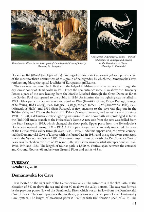
45
Horseshoe Bat (Rhinolophus hipposideros). Finding of invertebrate Eukoenenia spelaea represents one of the most northern occurrences of this group of palpigrades, by which the Demänovské Caves rank among biospeleological localities of European significance.
The cave was discovered by A. Král with the help of A. Mišura and other surveyors through the dry lowest ponor of Demänovka in 1921. From the new entrance some 10 m above the Discovery Ponor, a part of the cave leading from the Marble Riverbed through the Great Dome as far as the Golden Pool was opened to the public in 1924. An interim electric lighting was installed in 1923. Other parts of the cave were discovered in 1926 (Jánošík’s Dome, Virgin Passage, Passage of Suffering, Red Gallery), 1927 (Magical Passage, Violet Dome), 1929 (Svantovít’s Halls), 1930 (Miraculous Halls) and 1931 (Bear Passage). A new entrance to the cave was dug out in the Točište Valley in 1928 on the basis of E. Paloncy’s measurements, and serves for visitors since 1930. In 1931, a definitive electric lighting was installed and show path was prolonged as far as the Pink Hall and a branch to the Hviezoslav’s Dome. A new exit from the cave was drilled from the Bear Passage in 1933, which changed the show path. Upper parts from the Hviezdoslav’s Dome were opened during 1931 – 1933. A. Droppa surveyed and complexly measured the caves of the Demänovská Valley through years 1948 – 1955. Under his supervision, the cavers connec-ted the Demänovská Cave of Liberty with the Pustá Cave in 1951, and the speleodivers connected it with the Vyvieranie Cave in 1983. The natural interconnection with the Demänovská Cave of Peace was reached on the turn of 1986 and 1987, after some unsuccessful attempts done in 1952, 1968, 1974 and 1983. The length of tourist path is 1,800 m. Vertical span between the entrance and Ground Floor is -66 m, between Ground Floor and exit is +85 m.
tueSdayoctober 19, 2010
demänovská Ice Cave
It is located on the right side of the Demänovská Valley. The entrance is in the cliff Bašta, at the elevation of 840 m above the sea and about 90 m above the valley bottom. The cave was formed by the previous ponor flow of the Demänovka River, which was an inflow from the Demänovská Cave of Peace. The cave represents the northern, previous resurgence part of the Demänovský Cave System. The length of measured parts is 1,975 m with the elevation span of 57 m. The
Demänovka River in the lower part of Demänovská Cave of Liberty. Photo by M. Rengevič
Crustacean Niphargus tatrensis – typical inhabitant of underground stream
in the Demänovské Caves. Photo by Z. Višňovská

46
cave spaces spread in three development levels and consist of oval, river-modelled passages with ceiling and side troughs (Black Gallery, Lake Passage, Bear Passage) and dome spaces reshaped by collapses and frost weathering (Gravel Dome, Great Dome, Kmeť’s Dome, Bel’s Dome, Halaš’s Dome, Dome of Ruins). They descend from the entrance into the depth of 40 to 50 m.
Ice fill occurs in the lower parts, mostly in the Kmeť’s Dome. We can find here floor ice, ice columns, stalactites and stalagmites. The conditions for glaciation started after burying several openings to the surface in consequence of slope modelling processes, by which the air circulation was restricted. Heavier cold air is kept in the lower parts of the cave. Seeping pre-cipitation water freezes in overcooled under-ground spaces. Air temperature in glaciated parts fluctuates around 0 °C and in direction to the back non-glaciated parts rises from 1.3 up to 5.7 °C. Relative air humidity is between 92 and 98 %. Original flowstone fill was pre-served in several places of the cave (stalactites, stalagmites, flowstone covers on the walls, f loor crusts and other forms), which is, howe-ver, considerably destroyed by frost weathering in the glaciated part of the cave. Dripstone and
flowstone formations are coloured on the surface from grey to black from soot of tar torches, oil burners and paraffin lamps, which were used for lighting until 1924.
The cave belongs among long known finding places of bones of various vertebrates including the cave bear (Ursus spelaeus), which were in the first half of the 18th century considered dra-gons’ bones. That’s why the cave was called Dragon Cave in the past. By now, eight bat species were found in its underground spaces. It represents the most important wintering place of the Northern Bat (Eptesicus nilssonii) and the second most important one of the Whiskered/Brandt’s Bat (Myotis mystacinus/Myotis brandtii) in Slovakia.
It is passed on that the Demänovská Ice Cave is known from time immemorial. The first mention about the openings to caves in the Demänovská Valley is recorded in the Esztergom Chapter docu-ment from 1299. The first written mention about the Demänovská Ice Cave is related to the descrip-tion of a cave not far from Liptovský Mikuláš and comes from 1672 by J. P. Hain who was interested in cave bear bones and took them for dragons’ bones. Further mentions of the Demänovská Ice Cave are connected with G. Buchholtz jr., who surveyed its spaces in 1719. He sent the description together with a sketch of the cave to M. Bel, who published the data in 1723. German physician and naturalist F. E. Brückmann visited the cave in 1724. Many other travellers, naturalists and publis-hers wrote about the cave – J. M. Korabinský (1778), K. G. Windisch (1780), B. Hacquet (1790), R. Townson (1797), S. Bredetzky (1801), F. Sartori (1809), K. A. Zipser (1817), A. W. Sydow (1830) and others. The wealth of wall inscriptions and preserved rich literature evidence the great interest of then scientific groups as well as general public in this cave. Signatures of important personalities of the Slovak history remained on its walls. The initial tourist opening the cave for public happened around the half of the 19th century. German naturalist B. Schwalbe examined the genesis of local ice in 1881. American geographer E. S. Balch visited the cave with the aim of ice investigation in
Ice column, Demänovská Ice Cave. Photo by M. Rengevič

47
1896. The interest in the Demänovská Ice Cave fell down after opening the Demänovská Cave of Liberty for the public in 1924. The upper dripstone parts of the cave were discovered in 1926. The cave was reopened for the public during 1950 – 1952, including installation of electric lighting. The Demänovská Cave of Peace were discovered from the Lake Passage of Demänová Ice Cave in 1952. Since these impacts deteriorated the temperature regime of the cave, measures were taken to renew the ice fill during 1953 – 1954 (closing of tunnelled opening to the Dome of Ruins, building a wall for dividing glaciated and non-glaciated parts). First climatic observations were performed during 1953 – 1956. Public has access to 650 m with elevation span of -48 m.
WedNeSdayoctober 20, 2010
Trip route: Demänovská Valley – Liptovský Mikuláš – Poprad – Vernár – Dobšinská Ice Cave
Slovak Paradise
It is situated in the Spiš-Gemer Karst in the north part of Slovenské rudohorie Mts. Altitudes above sea level fluctuate between 500 m (on the border with the Hor nádska Basin) and 1,150 m (Havrania skala – the highest hill). The relief generally decreases from the south to the north which is a consequence of a megaanticline of the Slo venské rudohorie Mts.
The Slovak Paradise is regarded as a significant karst territory. The Middle Triassic limestones prevail in the northern par t. Apart from limestones there are also numer-ous dolomites of the Middle and Upper Triassic in the southern part. In the north from the river Hornád there is an expansion of Paleogene conglomerates and sand- stones. The Slovak Para dise presents mountain karst plateau dissected by several karst valley fea-tures mainly by canyons of the Hornár River and Hnilec River and lots of ravines. The set of ravines with waterfalls had been originated by brooks which flow from centre of karst plateau to all direc-tions. Originally large karst plateau was divided by downcutting of river valleys into partial karst plateaux (Duča, Geravy, Glac, Pelc, Skala). On the territory of the Slovak Paradise there are 210 ca ves and chasms. The well-known caves are Dobšinská Ice Cave, Stratenská Cave and Bear Cave.
Kmeť´s Dome, Demänovská Ice Cave. Photo by P. Bella
Demänovská Ice Cave – the most important hibernation site of the
Northern Bat (Eptesicus nilssonii) in Slovakia. Photo by L. Vlček

48
The Slovak Paradise is considered one of the most beautiful natural areas in Slovakia. In 1964 it was proclaimed the Protected Landscape Area and in 1988 recategorised to the National Park. The national park covers the area of 197.63 km2 and the protected zone 130.11 km2. National Park Slovak Paradise is characterized by canyons, ravines, waterfalls and streams with karst forms that are available for tourists in the form of sidewalks, the more challenging parts and technical equip ment.
dobšinská Ice Cave
It is located on the south-western edge of the Slovak Paradise National Park in the Spiš-Gemer Karst. The cave entrance is on the northern slope of the Duča Hill at the elevation of 969 m and 130 m above the bot tom of the valley of Hnilec River. The character of its glaciation places this cave among the most important ice caves in the world, and its importance is accentu ated by its location outside the high mountain region of the Alps with the underground ice lying at eleva tions of only 920 to 950 m above the sea.
The Dobšinská Ice Cave is a part of the Stratenská Cave system. It was formed in the Middle Triassic pale Steinalm and Wetterstein limestones of the Stratená nappe along the tectonic faults and inter bed surfaces. The length of the cave is 1,483 m with a verti-cal span of 112 m. The main part of the cave is represented by a great cavity descending from the surface opening to the depth of 70 m. It was formed by a collapse of rock floors between passages for- Great Hall, Dobšinská Ice Cave. Photo by M. Rengevič
Kyseľ Ravine, Slovak Paradise. Photo by L. Vlček
Suchá Belá Ravine, Slovak Paradise. Photo by L. Vlček
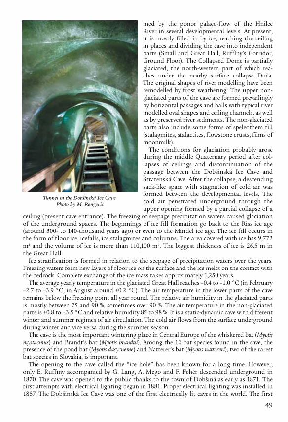
49
med by the ponor palaeo-flow of the Hnilec River in several develop mental levels. At present, it is mostly filled in by ice, reaching the ceiling in places and dividing the cave into independent parts (Small and Great Hall, Ruffíny’s Corridor, Ground Floor). The Collapsed Dome is partially glaciated, the north-western part of which rea-ches under the nearby surface collapse Duča. The original shapes of river modelling have been remodelled by frost weathering. The upper non-glaciated parts of the cave are formed prevailingly by horizontal passages and halls with typical river modelled oval shapes and ceiling channels, as well as by preserved river sediments. The non-glaciated parts also include some forms of speleothem fill (stalagmites, stalactites, f lowstone crusts, films of moonmilk).
The conditions for glaciation probably arose during the middle Quaternary period after col-lapses of ceil ings and discontinuation of the passage between the Dobšinská Ice Cave and Stratenská Cave. After the collapse, a descending sack-like space with stagna tion of cold air was formed between the develop mental levels. The cold air penetrated underground through the upper opening formed by a partial col lapse of a
ceiling (present cave entrance). The freez ing of seepage precipitation waters caused glaciation of the underground spaces. The beginnings of ice fill formation go back to the Riss ice age (around 300- to 140-thousand years ago) or even to the Mindel ice age. The ice fill occurs in the form of f loor ice, icefalls, ice stalagmites and columns. The area covered with ice has 9,772 m2 and the volume of ice is more than 110,100 m3. The biggest thickness of ice is 26.5 m in the Great Hall.
Ice stratification is formed in relation to the seep age of precipitation waters over the years. Freezing waters form new layers of floor ice on the surface and the ice melts on the contact with the bedrock. Complete exchange of the ice mass takes approxi mately 1,250 years.
The average yearly temperature in the glaciated Great Hall reaches –0.4 to –1.0 °C (in February –2.7 to –3.9 °C, in August around +0.2 °C). The air temperature in the lower parts of the cave remains below the freezing point all year round. The relative air humidity in the glaciated parts is mostly between 75 and 90 %, sometimes over 90 %. The air tem perature in the non-glaciated parts is +0.8 to +3.5 °C and relative humidity 85 to 98 %. It is a static-dynamic cave with different winter and summer regimes of air circulation. The cold air flows from the surface underground during winter and vice versa during the summer season.
The cave is the most important wintering place in Central Europe of the whiskered bat (Myotis mys tacinus) and Brandt’s bat (Myotis brandtii). Among the 12 bat species found in the cave, the presence of the pond bat (Myotis dasycneme) and Natterer’s bat (Myotis nattereri), two of the rarest bat species in Slovakia, is important.
The opening to the cave called the “ice hole” has been known for a long time. However, only E. Ruffíny accompanied by G. Lang, A. Mego and F. Fehér descended underground in 1870. The cave was opened to the public thanks to the town of Dobšiná as early as 1871. The first attempts with electrical lighting began in 1881. Proper electrical lighting was installed in 1887. The Dobšinská Ice Cave was one of the first electrically lit caves in the world. The first
Tunnel in the Dobšinská Ice Cave. Photo by M. Rengevič

50
plan of the cave comes from E. Ruffíny from 1871. The first climatic observations were done by F. Fehér in 1870 – 1871. J. A. Krenner, appointed by the Ugrian Royal Natural Scientific Society, investigated the cave in 1873. E. J. Pelech published a study on the cave in 1878, which was issued also in London one year later. A concert was held in the Great Hall in 1890 to the tribute of Charles Ludwig von Habsburg. The first summer skating took place in 1893. It attracted the attention of both experts and the general public immediately after its discovery. Many important personalities of the time visited the cave. The upper non-glaciated parts were discovered in 1947. At present, the visitors have access to 475 m with elevation range of -43 m.
Trip route: Dobšinská Ice Cave – Spišská Nová Ves – Spišské Podhradie
Spišský Castle
The ruins of Spišský Castle in eastern Slovakia is situated above the town of Spišské Podhradie and the village of Žehra, in the region known as Spiš. The castle was included in the UNESCO list of World Heritage Sites in 1993 together with the adjacent locations of Spišská Kapitula, Spišské Podhradie and Žehra. The Špišský Castle is the largest medieval castle compound in central Europe along with the little town of Spišské Podhradie (with typical Renaissance and Baroque burg-her houses), the Church town of Spišská Kapitula (including several sacral monuments and above all the impressing two tower cathedral of St. Martin) and the Gothic church of the Holy Spirit in Žehra from the 14th century and frescoes in its interior from the 14th and 15th centuries. Well conserved monuments along with the charming natural setting of the travertine territory of the National Nature Reserve dreveník forms a unique whole. In June 2009, the historic town of Levoča was included in this group of Spiš monuments.
Spišský Castle was built in the 12th century on the site of an earlier castle. It was the political, administrative, economic and cultural centre of Szepes County of the Kingdom of Hungary. Before 1464, it was owned by the kings of Hungary, afterwards (until 1528) by the Zápolya
Spišský Castle. Photo by P. Gažík
Old postcard illustrating ice summer skating in the Dobšinská Ice Cave in 1905

51
family, the Thurzo family (1531 – 1635), the Csáky family (1638 – 1945), and (since 1945) by the state (Czechoslovakia, and since 1993 Slovakia).
Originally a Romanesque stone castle with fortifications, a two-story Romanesque palace and a three nave Romanesque-Gothic basilica, were constructed by the second half of the 13th cen-tury. A second extramural settlement was built in the 14th century, by which the castle area was doubled. The castle was completely rebuilt in the 15th century; the castle walls were heightened and a third extramural settlement was constructed. A late Gothic chapel was added around 1470. The Zápolya clan performed late Gothic transformations, which made the upper castle into a comfortable family residence, typical of late Renaissance residences of the 16th and 17th cen-turies. The last owners of the Spišský Castle the family Csáky deserted the castle, in early 18th century considered too uncomfortable to live in. They moved to the newly build nearby village castles/palaces in Hodkovce by Žehra and Spišský Hrhov. In 1780, the castle burned down, and has been in ruins since. The castle was partly reconstructed in the second half of the 20th century, and extensive archaeological research was carried out on the site.
Trip route: Spišské Podhradie – Levoča – Poprad – Liptovský Ján
liptovský ján
Liptovský Ján is a gate to the Jánska Valley, rich on natural beauties, caves, flora, fauna, thermal water and mineral springs. At the same time it is an important tourist and recreational centre suitable for winter as well as summer vacation. The first written notice about the village is from the year 1327. The healing springs in Liptovský Ján were popular already in the 14th century. In 1963 a new thermal spring with temperature 29,4 °C was drilled in the depth 95 m. Thermal water is used in swimming pools. It was proved that water really has positive healing effects, especially on skin illnesses, illnesses of kinetic system, metabolism, gynaecologic, neurological, heart and vessels illnesses.
The Jánska Valley is located on the north side of Low Tatras and one of the most beauti-ful valleys. As a national nature reserve was declared in 1933. Also the Jánska Valley in the National Park Low Tatras belong to the most important underground karst site in Slovakia. The Hipmanove Caves – the deepest cave system in Slovakia (-495 m) are situated on the left side of the valley within the Krakova hoľa (1752 m).
tHuRSdayoctober 21, 2010
Trip route: Demänovská Valley – Liptovský Mikuláš – Liptovský Hrádok – Pribylina
Pribylina
The Museum of the Liptov Village in Pribylina is an extended exhibition of the Liptovské Museum at Ružomberok. Its first section was open to the public in 1991. This section includes buildings from the inundanted area of the water reservoir Liptovská Mara and from a few villages of Upper and Lower Liptov. An interesting building is also that of a school from Valaská Dubová and the dominant feature – a Gothic church of Our Lady from Liptovská Mara. Exhibition craft shops in residential houses, but also a blacksmith Kolárska allow visitors to bring skilled masters the secrets of ancient handicrafts. Museum of the schedule prepared for the public programs that have gained great popularity and favor with visitors. Each year the museum is also preparing a new thematic programs with examples of folk customs, spring customs, holidays and summer solstice celebrations, as well as winter Christmas folk programme.
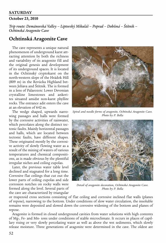
52
SatuRdayoctober 23, 2010
Trip route: Demänovská Valley – Liptovský Mikuláš – Poprad – Dobšiná – Štítnik – Ochtinská Aragonite Cave
ochtinská aragonite Cave
The cave represents a unique natural phenomenon of underground karst att-racting attention by both the richness and variability of its aragonite fill and the original genesis and development of its under ground spaces. It is located in the Ochtinský cryptokarst on the north-western slope of the Hrádok Hill (809 m) in the Revúcka Highland bet-ween Jelšava and Štítnik. The is formed in a lens of Palaeozoic Lower Devonian crystalline limestones and ankeri-tes situated amidst non-karst phyllite rocks. The entrance adit enters the cave at an elevation of 642 m.
The wedge shaped, upwards narro-wing passages and halls were formed by the corrosive activities of rainwater, which percolates along the distinct tec-tonic faults. Mainly horizontal passages and halls, which are located between tectonic faults, have different shapes. These originated mostly by the corrosi-ve activity of slowly flowing water as a result of the mixing of waters of various temperatures and chemical compositi-ons, as is made obvious by the plentiful irregular niches and ceiling cupolas.
Later, the previous water table level declined and stagnated for a long time. Corrosive flat ceilings that cut out the lower parts of ceiling cupolas and side corrosion notches on rocky walls were formed along the level. Several parts of the cave are characterized by triangular or trapezoid cross sections consist ing of flat ceiling and corrosive inclined flat walls (planes of repose), narrowing to the bottom. Under conditions of slow water circulation, the insoluble remains were deposited and slowed down the corro sive widening of the bottom and planes of repose.
Aragonite is formed in closed underground cavi ties from water solutions with high contents of Mg-, Fe- and Mn- ions under conditions of stable micro climate. It occurs in places of capil-lary rising or very slowly percolating water as well as above the wet sediments, which slowly release moisture. Three generations of aragonite were determined in the cave. The oldest are
Spiral and needle forms of aragonite, Ochtinská Aragonite Cave. Photo by P. Bella
Detail of aragonite decoration, Ochtinská Aragonite Cave. Photo by P. Bella

53
milky translucent kidney-shaped formations and their corroded remains (dated age of 121 – 138 thousand years) with partially recrystalized aragonite, in places metamorphosed to calcite. The second generation of aragonite prevails and occurs mostly in the form of several cm long needles and spiral helictites (dated age of 14 thousand years). These form cluster or dentritic formations (including so-called iron flower or anthodite), which are most attractive for visitors. Aragonite of the second gen eration is still growing, which enables it to maintain its white colour and clean appearance. The young est generation of aragonite, which is being formed at present on sediments and iron ochres makes tiny fans (2 – 4 mm in size and sometimes even bigger), sporadically creating miniature helictites.
The air temperature in the cave is between 7.2 and 7.8 °C, while relative humidity is between 92 and 97 %. Stabilization of the cave microclimate is caused by iron ochres (containing 47-56 volume percent of water) since they are able to absorb and release water vapour.
The cave was discovered by chance by M. Cangár and J. Prošek, employees of the East-Slovakian Ore Survey in Jelšava, while drilling the geological survey Kapusta Adit in 1954. The cave protec-tion was secured after finishing the geological survey in the Horný Hrádok locality. Cave deve-lopment works started in 1966 by drilling the access adit 145 m long, which enabled opening of the cave to the public in 1972. The length of the accessible part is 230 m.
Trip route: Ochtinská Aragonite Cave – Plešivec – Domica Cave
Slovak karst National Park
The Slovak Karst is one of the nine national parks in Slovakia. It is located in the south-eastern part of the Slovenské rudohorie Mts. close to the town of Rožňava. It is an exceptional limesto-ne landscape unit formed by large karst plains with fully developed karst phenomena. Karst relief appearing on the surface and underground is represented by a wide range of forms typical only for karst – karren, dolines, uvalas, poljes, blind valleys, karst cones, caves and abysses of various sizes and types. The caves, formed not only under the plateaux but also under their foothills, are an inseparable part of the karst phenome-non. More than 1,000 caves and abysses are registered in the Slovak Karst.
The Slovak Karst consists of the Silická, Plešivská, Koniarska, Dolný vrch, Horný vrch, Borčianska, Zádielska and Jasovská Plateau as well as the Jelšavský Karst. The plateaux lying at elevations of 400 – 925 m are bordered by steep slopes inclin ing to the bottoms of adjacent basins, canyons and gorges. The originally flat surface from the Younger Tertiary is divided by deep canyons of the Slaná and Štítnik River, as well as by the Zádielska and Hájska Gorge. The Turnianska Basin divides the Horný vrch and Dolný vrch plateaux.
The karst plateaux of Dolný vrch and Silická Plateau continue southward into the territory of Hungary, where they form the Aggtelek Karst. The Slovak and Aggtelek Karst, as a part of the Inner Western Carpathians, is a continuous karst territory lying both in Slovakia and Hungary, which represents a typical Central European plateau karst of the temperate climatic zone, with almost all surface and underground karst phenomena (karren, dolines, uvalas, dry and
Kečovo karrenfield, Slovak Karst. Photo by P. Bella

54
semi-dry valleys, canyons, gorges, border poljes, caves, abysses, ponors, springs). Caves and abys-ses of the Slovak Karst together with the caves of the Hungarian Aggtelek Karst lying in its neigh-bourhood, became a part of the world heritage as an exceptional natu ral phenomenon within the wider Central European region.
The territory of the Slovak Karst is drained
by the allochthonous Slaná, Štítnik and Bodva rivers, into which autochthonous karst streams flow. The Slovak Karst has important resources of usable underground waters. This territory is located on the boundary of the oceanic and continental type of climate with prevailing western airflow. The prevail ing part of the territory belongs to the moderately warm and moderately humid climatic region with a cold winter. Concerning the elevation above the sea, it lies on the transition between the lowland and mountain types of climate. Climatic inversions, which cause vegetation inversions, occur mainly in the deep gorges of the Zádielska and Hájska Valley. Mainly during the Wallachian Colonization in 13th and 14th centuries, the territory was partially defor-ested and consequently transformed into karstified steppe.
The recognition of the great natural value of the Slovak Karst is expressed in the inclusion of its most precious part in the international network of biospheric reserves within the program Man and the Biosphere (MaB). Several national nature reserves, nature reserves, national nature monuments as well as protected areas of European importance represent varied natural units and phenomena both on the surface and underground within the national park.
domica Cave
It is located on the south-western edge of the Silická Plateau, close to the state border with Hungary. The entrance to Domica is in the southern foot-hills of the homonymous hill at an elevation of 339 m. Apart from its significant geomorpho-logical values, the cave is unique for its archaeological dis coveries, abundant occurrence of calcite shields and drums as well as by the plentiful species com-position of its bats.
The cave is formed in the Mesozoic Middle Triassic pale Wetterstein limestones of the Silica Nappe like the majority of
Dolines on the planation surface of Silická Plateau, Slovak Karst. Photo by Ľ. Gaál
Domica Cave – well-known site of numerous occurrence of shields. Photo by P. Bella

55
other caves in the Slovak Karst. The underground passages are the result of corrosive and erosive activities of the underground streams of Styx, Domický Brook and smaller tributaries, which drain mainly the waters flowing from the non-karst part of the cave catchment area. Three developmen-tal levels, representing main cave passages, are relatively lowered by 8 to 12 meters. The lowest level is filled up with gravels and clay.
The Domica Cave is connected with the Čertova diera Cave and together they reach the length of 5,358 m. They form an integrated genetic unit with the Baradla Cave in Hungary with the total length of more than 25 km, from which almost 1/4 lies in the territory of Slovakia.
Horizontal oval passages with ceiling channels dominate the Domica Cave. The passages are enlarged into domes and halls in some places. Near the state border the passage of Styx gains the char acter of underground canyon with meanders.
The cave is rich in speleothems, from which the most typical are shields and drums, cascade pools (Roman Spa, Plitvice Lakes), onion-like stalactites and pagoda-like stalagmites. The air temperature ranges from 10.2 to 11.4 °C and relative humidity from 95 to 98 %.
Cave bear bones were dug out in the Dry Passage (Ursus spelaeus). Sixteen bat spe cies have been observed in the Domica and Devil’s Hole Cave up to now. The dominant species is the Mediterranean horseshoe bat (Rhinolophus euryale), which forms a colony of some 1,000 – 2,000 mem bers here – the only one of such a kind in Slovakia. Thick layers of bat excrements – guano can be found in some places. Its chemical reaction with flowstone cre ated guano pots. From among the tiny invertebrates 44 species of springtails were found here (the most important is the endemic Arrhopalites slovacicus), rare palpigrade Eukoenenia spelaea, multipede of Typhloiulus genus, crustacean Niphargus tatrensis and many other species of terrestrial and water fauna.
Underground boat ride in the Domica Cave. Photo by M. Rengevič
Majko’s Dome and Roman Spa, Domica Cave. Photo by M. Rengevič

56
Domica offered short-term shelter to the oldest Neolithic inhabitants of eastern Slovakia – the cre ators of the Eastern Linear Pottery Culture – its local branch the so-called Gemer Linear Pottery. However it was settled mainly by the Neolithic people of the Beech (Bükk) Mountain culture. Later the original entrance to the cave was choked by debris and the cave became inaccessible.
The Old Domica Cave wask-nown for a long time. J. Majko penetrated in 1926 from its bot-tom through an abyss into the large under ground cave spaces of Domica, where many diverse archaeological discoveries were found.
Post holes from dwelling objects and fireplaces were discovered in several places in the cave. Many reconstructed containers from sherds as well as a terrace-dug slope in a fine-grained loam on the Styx bank with imprints of stone axes are evidences of pottery manufacture. Irons, awls, arrows, a comb, ring, decorated cylinder bracelet and fishhook rep resent the peak of Neolithic processing of bones. Pendants made from shells and animal teeth were also preserved. Stone instruments comprise pol ished axes, wedges and mallets with drilled holes and split stone tools – knives and scrapers. The evidence of fabric production is the finding of a thick fabric imprint in the loam (the oldest one in Slovakia), clay whorls as well as a fragment of the conic weaving weight unit. The rear parts of the cave probably served as a sacred and cult place where charco-al drawings were preserved. Domica is one of the most important finding places of the Bükk Mountain Culture in Slovakia.
The Club of Czechoslovak Tourists dug out the lower entrance in 1930 and opened the cave to the public, including electric lighting and damming up the Styx in 1932 for the underground boat trip. At present, public has access to 1,315 m, including the 140 m long underground boat ride.
Only occasional underground water courses flow through the cave. The cave was several times catastrophically flooded during intensive storms in the past. Hence it is necessary to guide the agricul tural activities to prevent accelerated runoff and soil erosion.
The westernmost part of the cave system, close to the edge ponor dolines, is formed by the Devil’s Hole Cave. Its underground spaces descend from the opening down to the Styx river-bed. Mainly stick stalagmites are attractive for the visitors. The easy accessible parts near the entrance to the cave have been known for a long time. L. Bartolomeides wrote about the cave in 1801. The presumed connection of the Domica Cave with the Devil’s Hole Cave was proved by J. Majko in 1929.
Pot of the Bükk-Mountain Culture covered by thin flowstone in the Domica Cave. Photo by P. Bella