Embed Size (px)
Citation preview

Springfield, Massachusetts
INTERSTATE 91 VIADUCT STUDY
CHAPTER V
RECOMMENDATIONS
August 2018
MMI #3869-16-6

INTERSTATE 91 VIADUCT STUDY CHAPTER V
SPRINGFIELD, MASSACHUSETTS TC-i
TABLE OF CONTENTS
5.1 Summary of Recommendations .............................................................................................................................. 1
5.2 Alternatives Considered .......................................................................................................................................... 3
5.2.1 ALTERNATIVES DEVELOPMENT PROCESS ............................................................................................. 3
5.2.2 SUMMARY OF ALTERNATIVES EVALUATED .......................................................................................... 3
5.2.3 EVALUATION CRITERIA ............................................................................................................................. 5
5.2.4 BENEFIT AND COST DIFFERENTIATORS ................................................................................................. 6
5.3 Near-/Mid-Term Improvements ............................................................................................................................ 11
5.3.1 NEAR-TERM IMPROVEMENTS ............................................................................................................... 12
5.3.2 MID-TERM IMPROVEMENTS .................................................................................................................. 16
5.3.3 NEAR- AND MID-TERM RECOMMENDATIONS ................................................................................... 18
5.4 Implementation ..................................................................................................................................................... 19
5.4.1 MASSDOT PROJECT DEVELOPMENT AND DESIGN PROCESS .......................................................... 19
5.4.2 ENVIRONMENTAL CONSIDERATIONS .................................................................................................. 25
5.4.3 IMPLEMENTATION SUMMARY .............................................................................................................. 26
Figures:
Figure 5-1 Near- and Mid-Term Improvements (South Section) ..................................................................... 11
Figure 5-2 Near- and Mid-Term Improvements (North Section) ..................................................................... 12
Figure 5-3 Conceptual Rendering of Under-Viaduct Enhancements ............................................................... 13
Figure 5-4 I-91/I-291 Interchange Improvements ............................................................................................ 17
Figure 5-5 Plainfield Street Improvements ...................................................................................................... 17
Figure 5-6 Schematic Project Development Time Line .................................................................................... 25
Tables:
Table 5-1 Alternatives Comparison (Viaduct Only) ........................................................................................... 9
Table 5-2 Project Development Summary ...................................................................................................... 23

INTERSTATE 91 VIADUCT STUDY CHAPTER V
SPRINGFIELD, MASSACHUSETTS PAGE 1
5.1 SUMMARY OF RECOMMENDATIONS
The previous chapter of the Interstate 91 Viaduct Study, Alternatives Analysis, examined and evaluated a No-Build scenario and three build alternatives in detail to determine how each alternative performed across a range of evaluation criteria. This chapter concludes the study by summarizing the alternative selection process, detailing near-term and mid-term improvements recommended for project development, and the implementation process for acting on the recommendations of this study.
In selecting the recommended improvements to be made in the Primary Study Area, the most important considerations were how each improvement met the goals and objectives of the study, the evaluation of each alternative against the evaluation criteria outlined in Chapter IV, the input of the Working Group, and the cost effectiveness of improvements.
Of the three Build Alternatives examined in detail in Chapter IV (Alternatives Analysis), it was apparent that Alternatives 1 and 2 would provide tangible local improvements in the immediate area of the sunken or depressed highway alignments. The greatest benefits of these alternatives are derived from reconnection of the urban core to the river with greatly enhanced pedestrian connections, major improvements to the character and visual profile of the Interstate 91 (I-91) alignment through Downtown Springfield, increases in potentially developable land, and an overall increase in open space within the current transportation corridor. By contrast, the extent of local benefits provided by Alternative 3 in terms of improvements to local visual character, reconnection of Downtown Springfield to the riverfront, and additional developable land and open space is substantially reduced compared to Alternatives 1 and 2 while still incurring greatly increased costs compared to the No-Build alternative.
It is also apparent that even with the implementation of any of the three alternatives unimpeded access to the riverfront will continue to be severely limited by the existing, active railroad alignment. Although relocation of the railroad was investigated in several preliminary alternatives discussed in Chapter III, it was determined that such a design would not be feasible. Major impediments to relocating the railroad tracks include recent and planned investments in Hartford Line commuter rail service between New Haven, Hartford, and Springfield (and the associated projected increases in passenger rail ridership) and the high costs and land takings impacts associated with any alternative that relocated the railroad tracks to the west side of the Connecticut River.
Upon consideration of all factors evaluated in this study, including benefits, impacts, and cost, none of the Build Alternatives will be recommended for advancement to the project development process at this time. It is apparent that many of the benefits identified within the alternatives that address current deficiencies or safety concerns within the study area could be fully or partially achieved through near- and mid-term improvements, which are not contingent upon replacement of the existing elevated viaduct structure. Many of the more feasible near- and mid-term improvements combined with a No-Build (rehabilitation) scenario of the actual elevated viaduct may achieve many of the locally desirable benefits outlined in Alternatives 1 through 3 at substantially lower costs. In particular, significant functional traffic and safety improvements are recommended for the section of highway known as the

INTERSTATE 91 VIADUCT STUDY CHAPTER V
SPRINGFIELD, MASSACHUSETTS PAGE 2
Longmeadow Curve, which is south of the actual elevated viaduct and the I-291/91 ramp systems, but were not improved with the most recent deck replacement project (2017-2018).
The recommendation of this report is that the No-Build scenario's course of future viaduct rehabilitation be pursued. Additionally, it is recommended that the near- and mid-term improvements discussed in section 5.3 below be considered for advancement to the project development process. These improvements serve to provide cost-effective means of advancing the study's goals of improving the function of I-91 and the local transportation network; enhancing connectivity between Downtown Springfield and the Connecticut River; and preserving and improving quality of life for residents, commuters, businesses, and visitors to Downtown Springfield.

INTERSTATE 91 VIADUCT STUDY CHAPTER V
SPRINGFIELD, MASSACHUSETTS PAGE 3
5.2 ALTERNATIVES CONSIDERED
Chapter III outlined the set of initial alternatives assessed in terms of their broad merits, feasibility, and ability to achieve the major goals and objectives of the study while Chapter IV detailed the methodology and results of the alternatives assessment process. The final result of this process was the Evaluation Matrix presented and discussed in sections 4.4 and 4.5, which provides measures of positive and negative impacts of each alternative across 62 criteria. These criteria spanned the categories of Mobility and Accessibility, Safety, Environmental Effects, Land Use and Economic Development, Community Effects, and Cost.
5.2.1 ALTERNATIVES DEVELOPMENT PROCESS
As described in greater detail in Chapters III and IV, the study team developed a set of alternatives based on an initial analysis of potential highway and roadway alignments. This process included a review of high-level goals and development of preliminary schematic concepts. The preliminary set of alternatives was assessed and refined in consultation with the Working Group and public input. Ten alternatives were developed as follows:
• Retain Existing Elevated Viaduct• At-Grade Section• Depressed Section• Depressed Section with Railroad• Tunnel Section• Elevated Section• U.S. Route 5 Realignment• I-91 West Side• Northbound and Southbound Split• Relocation of Railroad Right-of-Way
From this list of alternatives, four (including the No-Build option) were selected as viable and advanced to the alternatives evaluation phase, the methodology and results of which are presented in Chapter IV. In addition to the No-Build alternative, the three scenarios selected for evaluation were the following:
• Alternative 1: Depressed, Same Alignment• Alternative 2: Depressed, New Alignment• Alternative 3: Modern Viaduct
5.2.2 SUMMARY OF ALTERNATIVES EVALUATED
The No-Build conditions described in Chapter II form the baseline for evaluation of the three alternatives. This scenario depicts projected 2040 conditions, including known and anticipated changes to transportation infrastructure in the Primary and Regional Study Areas. Under this scenario, the I-91

INTERSTATE 91 VIADUCT STUDY CHAPTER V
SPRINGFIELD, MASSACHUSETTS PAGE 4
Viaduct Rehabilitation Project (which will be completed in summer 2018) is taken into account as a future viaduct rehabilitation project to be completed circa 2040, which would include both deck replacement and pier rehabilitation of the viaduct structure. The No-Build scenario is fully compatible with all recommended near-term and mid-term improvements discussed below.
Alternative 1 (Depressed, Same Alignment) presents a conceptual design for a depressed I-91 mainline alignment through Downtown Springfield, which would run below grade for approximately 4,200 feet along the existing interstate right-of-way (approximately between Broad Street and Boland Way). Three lanes would be maintained in each direction through the depressed section, with the I-91 mainline running below grade and an at-grade connection between Downtown Springfield and the Riverfront Area, including an area of open space between East and West Columbus Avenues.
An improved interchange between I-91 and I-291 would be provided with a redesigned connection from I-291 to I-91 southbound via a redesigned flyover, as well as reconfigured access to and from adjacent local roads. At the southern approach, the "Longmeadow Curve," U.S. Route 5/I-91 interchange, U.S. Route 5 and Route 57 interchange, and South End Bridge and U.S. Route 5 Bridge over the Westfield River would be improved (as described in section 5.3.2). In the Plainfield Street area, a pair of new bridges over the I-91 alignment and adjacent railroad tracks would be incorporated to enhance traffic operations and bicycle and pedestrian access to and from the North End Bridge and local streets. Bicycle and pedestrian accommodations would be introduced throughout the Primary Study Area as needed. Through Downtown Springfield, a net reduction of three ramps would reduce merging/diverging/ weaving sections and associated crashes.
Alternative 2 (Depressed, New Alignment) depicts a depressed I-91 mainline along a realigned right-of-way directly adjacent to the existing railroad line. This realignment would allow for the removal of some curvature of the mainline compared to the existing alignment, providing additional developable land and open space. As with Alternative 1, the below-grade interstate mainline would allow for an at-grade connection between Downtown Springfield and the Riverfront Area.
The Alternative 2 design also differs from Alternative 1 in the geometry of the I-291 to I-91 southbound flyover ramp due to the proximity of the realigned mainline to the railroad right-of-way; in the alignment of East and West Columbus Avenues as they proceed through Downtown Springfield above the depressed I-91 mainline; and in the removal of an additional Downtown Springfield ramp, with the potential for further reductions in congestion and safety issues associated with merging and diverging vehicles.
Other elements of the Alternative 2 conceptual design, including improvements to the Plainfield Street area, bicycle and pedestrian improvements, and the southern extent of the Primary Study Area, are substantially the same as presented in Alternative 1. At the southern approach, the "Longmeadow Curve," U.S. Route 5/I-91 interchange, U.S. Route 5 and Route 57 interchange, and South End Bridge and U.S. Route 5 Bridge over the Westfield River would be improved (as described in section 5.3.2). In the Plainfield Street area, a pair of new bridges over the I-91 alignment and adjacent railroad tracks would
INTERSTATE 91 VIADUCT STUDY CHAPTER V
SPRINGFIELD, MASSACHUSETTS PAGE 5
be incorporated to enhance traffic operations and bicycle and pedestrian access to and from the North End Bridge and local streets. Bicycle and pedestrian accommodations would be introduced throughout the Primary Study Area as needed. Through Downtown Springfield, a net reduction of four ramps would reduce merging/diverging/weaving sections and associated crashes.
Alternative 3 (Modern Viaduct) depicts an I-91 mainline similar to existing conditions but with the existing viaduct structure replaced with a "modern viaduct" design running approximately 10 feet higher than the current structure and supported by more widely spaced piers. Both of these design features would allow for more light, open space, and improved pedestrian conditions below the viaduct. As with the previous two alternatives, the mainline would provide three lanes in each direction. The I-291 to I-91 south ramp of the I-291/I-91 interchange would be improved as in Alternatives 1 and 2. However, unlike Alternatives 1 and 2, East and West Columbus Avenues would remain in their existing alignments.
Other elements of the Alternative 3 conceptual design, including improvements to the Plainfield Street area, bicycle and pedestrian improvements, and the southern extent of the Primary Study Area, are substantially the same as presented in Alternative 1. At the southern approach, the "Longmeadow Curve," U.S. Route 5/I-91 interchange, U.S. Route 5 and Route 57 interchange, and South End Bridge and U.S. Route 5 Bridge over the Westfield River would be improved (as described in section 5.3.2). In the Plainfield Street area, a pair of new bridges over the I-91 alignment and adjacent railroad tracks would be incorporated to enhance traffic operations and bicycle and pedestrian access to and from the North End Bridge and local streets. Bicycle and pedestrian accommodations would be introduced throughout the Primary Study Area as needed. Through Downtown Springfield, a net reduction of two ramps would reduce merging/diverging/weaving sections and associated crashes.
5.2.3 EVALUATION CRITERIA
The criteria against which each alternative was evaluated and rated were developed based on the goals and objectives identified as relevant to the study. Conditions for each alternative were compared to the benchmark of projected 2040 No-Build conditions, which are further elaborated on in Chapter II. Evaluation criteria were organized into the following six subject areas, as described in Chapter I:
• Mobility and Accessibility: Maintain or improve the conveyance of regional traffic through the corridor while enhancing the connectivity of all modes of transportation throughout the region.
• Safety: Create a safer and more user-friendly pedestrian, bicycle, and vehicular transportation system through and across the transportation corridor.
• Environmental Effects: Improve the overall environmental quality of the transportation corridor. • Land Use and Economic Development: Design transportation-based improvements that create
beneficial land use opportunities for the city and the region that promote both access to open space and new opportunities for economic development.
• Community Effects: Minimize temporary impacts to all stakeholders while understanding and maximizing the future benefits of a completed project.

INTERSTATE 91 VIADUCT STUDY CHAPTER V
SPRINGFIELD, MASSACHUSETTS PAGE 6
• Cost: Development of alternative designs will combine the approach of feasibility, creativity, and long-term sustainability.
Detailed descriptions of each evaluation criterion and the methodologies used to evaluate the alternatives are presented in sections 4.2 and 4.3 while the results of the evaluation process are presented in detail in section 4.4 and summarized with respect to key differentiators in section 4.5.
5.2.4 BENEFIT AND COST DIFFERENTIATORS
Major costs and benefits of each alternative are summarized in Table 5.1 (Alternatives Comparison – Viaduct Only) below. These factors are based on the more detailed Evaluation Matrix presented in section 4.4. Major factors that were identified as differentiating the three Build Alternatives from each other and from the No-Build scenario are outlined in section 4.5 of the study.
Alternative 1 is distinguished from other alternatives by the following factors, with corresponding evaluation criteria noted parenthetically.
• Reduced AM/PM delay times and enhanced level of service (LOS) on Downtown Springfield local streets compared to No-Build and Alternatives 2 and 3 (1.1.1)
• Net reductions in travel times between representative origin/destination pair for northbound and southbound AM peak and southbound PM peak (1.2.2)
• Reduced I-91 average travel times during AM and PM peaks vs. No-Build conditions and Alternative 2 and reductions in the number of weaving segments and crash clusters on the I-91 mainline (1.2.1, 2.2.1, 2.2.2).
• Increase in green space of 10.7 acres, providing space for outdoor recreation and community events as well as enhancing stormwater drainage (3.1.2)
• Diminished noise impacts and noise levels due to below-grade I-91 mainline compared to No-Build and Alternative 3 (3.3.1, 3.3.2)
• Potential positive impacts to Downtown Springfield aesthetic experience, perception of safety, and property values due to removal of viaduct structure relative to No-Build and Alternative 3 (2.3.1, 5.1.1)
• Improved accessibility for pedestrians and bicyclists throughout Downtown Springfield (1.3.1 – 1.3.5, 4.1.3)
• Potential housing and economic development impact made possible by enhanced accessibility of developable land on the order of 285 housing units, 1,325 jobs, and the potential for $2.2 million in annual property tax revenue (4.1.4, 4.1.5, 4.2.1 – 4.2.3)
• Highest estimated costs at $2.95 billion (inclusive of improvements to the viaduct structure, ramps, and adjacent infrastructure only); near- and mid-term projects are excluded. Estimated maintenance costs of $1.75 million per year also exceed expected maintenance costs of either

INTERSTATE 91 VIADUCT STUDY CHAPTER V
SPRINGFIELD, MASSACHUSETTS PAGE 7
the existing viaduct or the modern viaduct structure proposed in Alternative 3 (6.1.1, 6.1.2, 6.2.1).
Alternative 2 is distinguished from other alternatives by the following factors:
• Reduced AM peak delay times and enhanced LOS in Downtown Springfield but increased delays and poorer LOS in PM peak compared to No-Build; net impacts are expected to be roughly neutral (1.1.1).
• Travel times between representative origin/destination pairs improve for southbound trips but worsen for northbound trips due to several factors including differing roadway alignments and dispersed effects of the highway realignment (1.2.2).
• Reduced I-91 average travel times for southbound traffic but increased travel times for northbound traffic during both AM and PM peaks; weaving segments and crash clusters on the I-91 mainline are reduced (1.2.1, 2.2.1, 2.2.2).
• Increase in green space of 12.7 acres, providing the greatest amount of space for outdoor recreation and community events as well as enhancing stormwater drainage to the greatest extent of the alternatives (3.1.2)
• Diminished noise impacts and noise levels due to below-grade I-91 mainline compared to No-Build and Alternative 3 (3.3.1, 3.3.2)
• Potential positive impacts to Downtown Springfield aesthetic experience, perception of safety, and property values due to removal of viaduct structure, relative to No-Build and Alternative 3 (2.3.1, 5.1.1)
• Greatest potential housing and economic development impact made possible by enhanced accessibility of developable land on the order of 480 housing units, 2,330 jobs, and the potential for $3.5 million in annual property tax revenue (4.1.4, 4.1.5, 4.2.1 – 4.2.3)
• High estimated costs (at $2.93 billion (inclusive of improvements to the viaduct structure, ramps, and adjacent infrastructure only); near- and mid-term projects are excluded. Estimated maintenance costs of $1.75 million per year also exceed expected maintenance costs of either the existing viaduct or the modern viaduct structure proposed in Alternative 3 (6.1.1, 6.1.2, 6.2.1).
Alternative 3 is distinguished from the other alternatives by the following factors:
• Increased AM peak delay times but decreased PM peak delay times in Downtown Springfield (roughly neutral net impacts) (1.1.1)
• Net reductions in travel times between representative origin/destination pair for northbound and southbound AM peak and southbound PM peak (1.2.2)
• Reduced I-91 average travel times during AM and PM peaks vs. No-Build conditions and Alternative 2 and reductions in the number of weaving segments and crash clusters on the I-91 mainline (1.2.1, 2.2.1, 2.2.2)

INTERSTATE 91 VIADUCT STUDY CHAPTER V
SPRINGFIELD, MASSACHUSETTS PAGE 8
• Limited increase in green space (<1 acre) under the existing viaduct alignment, yielding limited additional space for recreation (3.1.2)
• Small reductions in noise impacts and noise levels due to increase in elevation of the modern viaduct concept (3.3.1, 3.3.2)
• Moderate potential positive impacts to Downtown Springfield aesthetic experience, perception of safety, and property values due to less visually imposing viaduct than the existing structure (2.3.1, 5.1.1)
• Limited potential housing and economic development on the order of 54 housing units, 136 jobs, and approximately $300,000 in annual property tax revenue (4.1.4, 4.1.5, 4.2.1 – 4.2.3)
• High estimated costs of $2.31 billion albeit lower than those estimated for Alternatives 1 and 2. (Estimate is inclusive of improvements to the viaduct structure, ramps, and adjacent infrastructure only; near- and mid-term projects are excluded.) Estimated maintenance costs of $1.25 million per year also exceed expected maintenance costs of the No-Build alternative (6.1.1, 6.1.2, 6.2.1).

INTERSTATE 91 VIADUCT STUDY CHAPTER V
SPRINGFIELD, MASSACHUSETTS PAGE 9
Table 5-1: Alternatives Comparison (Viaduct Only)
Alternatives Comparison (Viaduct Only) No-Build Alt 1 Alt 2 Alt 3
h_TJ • •lll1•Tj
1-91 Levels of Service No improvement in ramp or
merge/diverge/weave LOS
Improved ramp LOS, slightly
improved merge/diverge/weave
LOS
Improved ramp LOS, improved
merge/diverge/weave LOS
Improved ramp LOS, slightly
improved merge/diverge/weave
LOS
1-91 Travel Time (vs. No-
Build peak hour times)
No improvement in AM/PM
travel times Slightly faster in AM and PM
Slightly slower in AM/slightly
faster in PM Slightly faster in AM and PM
Safety
Weaving Segments No change in weaving
segments Removed 7 weaving segments Removed 6 weaving segments Removed 6 weaving segments
Crash Clusters No change in crash clusters
15 crash clusters redesigned to
enha nee safety
15 crash clusters redesigned to
enhance safety
15 crash clusters redesigned to
enhance safety
Under-Viaduct Conditions No change in under-viaduct
conditions
Viaduct removed; green space
created above depressed
alignment
Viaduct removed; green space
created above depressed
alignment
Modern elevated viaduct with
improved lighting, less visual
obstruction
l..l•Hlll•
Physical Footprint No change in impervious
surface
18 fewer acres of impervious
surface
11 fewer acres of impervious
surface
5 fewer acres of impervious
surface
Wetlands Impacts No wetlands impact 26,900sf wetlands impacts 26,900sf wetlands impacts 26,900sf wetlands impacts
Noise No change in noise impacts
Significantly reduced noise
impacts (198 fewer properties
impacted)
Significantly reduced noise
impacts (223 fewer properties
impacted)
Moderately reduced noise
impacts (179 fewer properties
impacted)

INTERSTATE 91 VIADUCT STUDY CHAPTER V
SPRINGFIELD, MASSACHUSETTS PAGE 10
No-Build Alt 1 Alt 2 Alt 3Alternatives Comparison (Viaduct Only)
Land Use and Economic Development
Development Scenarios No new greenspace/ development land
available
26 acres of new greenspace/ development land available
26 acres of new greenspace/ development land available
1 acre of new greenspace/ development land available
Economic Impacts No new housing or jobs
from conceptual development
285 housing units, 550 persons 1,325 jobs from conceptual
development
460 housing units, 888 persons, 2,330 jobs from conceptual
development
54 housing units, 104 persons, 136 jobs from conceptual
development
Freight Rail ImpactsNo impacts on rail
operations Moderate impacts on rail
operations Significant impacts on rail
operations Limited impacts on rail
operations Parking Impacts No reduction in parking Net reduction of 700 spaces Net reduction of 700 spaces Net reduction of 1,100 spaces
Community Effects
Visual ImpactsNo change in visual impact
of viaduct structure 4,200ft depressed alignment
covered 4,300ft depressed alignment
covered
Higher viaduct structure than existing; reduced number of
vertical piers/columns
Construction Impacts0 - 5 year maintenance/
rehab duration 10 - 15 year construction
duration 10 - 15 year construction
duration 8 - 12 year construction
duration Cost
Construction Costs $750m $2.95bn $2.92bn $2.31bn Maintenance Costs $500,000/year $1.75m/year $1.75m/year $1.25m/year

INTERSTATE 91 VIADUCT STUDY CHAPTER V
SPRINGFIELD, MASSACHUSETTS PAGE 11
5.3 NEAR-/MID-TERM IMPROVEMENTS
In addition to the alternatives contemplated for replacement of the I-91 Viaduct, a number of improvements that could be implemented as stand-alone projects were identified over the course of the project. Conceptual estimates of construction costs for each of these projects were developed independently of the viaduct options, allowing for the potential benefits, costs, and feasibility of each of these improvements to be assessed independently. It should be noted that the size and scale of several of these improvements can range significantly, thus the anticipated cost and schedules may also vary from the numbers shown below.
The near- and mid-term improvements discussed below are depicted on the maps below.
Figure 5-1: Near- and Mid-Term Improvements (South Section)

INTERSTATE 91 VIADUCT STUDY CHAPTER V
SPRINGFIELD, MASSACHUSETTS PAGE 12
Figure 5-2: Near- and Mid-Term Improvements (North Section)
5.3.1 NEAR-TERM IMPROVEMENTS
The near-term improvements recommended for implementation include the following potential projects. Each project profile describes potential benefits, impacts in terms of traffic operations disruptions and land takings/easements, and costs and time lines for construction (not including design, permitting, or programming for funding).

INTERSTATE 91 VIADUCT STUDY CHAPTER V
SPRINGFIELD, MASSACHUSETTS PAGE 13
Enhanced Under-Viaduct Pedestrian Plazas Description: Installation of park space, decorative safety lighting, recreational amenities, seating, and public art below the existing viaduct structure. Benefits: Enhanced safety and sense of security due to lighting and increased pedestrian surveillance; amenity benefits for local residents; enhanced connections between Downtown and Connecticut River. Impacts: Minor impacts on East and West Columbus Avenue, potential impacts on Taylor Street. Permitting/Design Time: 1-3 Years Cost & Construction Time: $100,000 to $500,000 / 1-3 years
Figure 5-3: Conceptual Rendering of Under-Viaduct Enhancements

INTERSTATE 91 VIADUCT STUDY CHAPTER V
SPRINGFIELD, MASSACHUSETTS PAGE 14
Enhanced Riverfront Bike/Ped Connections Description: Safety improvements to at-grade pedestrian (rail and street) connections to Connecticut Riverfront Park/Connecticut Riverwalk and Bikeway. Benefits: Enhanced pedestrian safety and accessibility to Connecticut Riverfront recreational amenities Impacts: Minor construction impacts on East/West Columbus Avenue. Permitting/Design Time: 1-2 Years Cost & Construction Time: $500,000 - $1m / 1-2 years
South End Bridge - River Road Bike/Ped Connection Description: Installation of an accessible bike and pedestrian ramp or switch-back path from South End Bridge to River Road and the adjacent neighborhood. Benefits: Enhanced bicycle and pedestrian safety and accessibility between Springfield/Longmeadow and the River Road neighborhood. Impacts: Potential minor construction impacts on South End Bridge and River Road. Permitting/Design Time: 1-2 Years Cost & Construction Time: $1m - $2m / 1-2 years
Hall of Fame - Riverfront Pedestrian Bridge Improvements Description: Installation of enhanced wayfinding signage, lighting, and sidewalk design to improve usefulness of pedestrian bridge between Riverfront Park and former Hall of Fame building. Benefits: Enhanced pedestrian safety and accessibility to Riverfront from Hall of Fame, adjacent businesses, and Downtown Springfield. Impacts: Potential minor construction impacts on West Columbus Ave, Union Street, and Connecticut Riverwalk and Bikeway Permitting/Design Time: 6 months - 1 Year Cost & Construction Time: $50K-$100K / 1 year
U.S. Route 5 Shared Use Path Description: Installation of a shared-use path along the existing gap in the pedestrian network on U.S. Route 5 between Laurel Hill Road and Forest Glen Road. Benefits: Enhanced bicycle and pedestrian safety and accessibility between Springfield, Longmeadow, and Forest Park. Impacts: Potential minor construction impacts on U.S. Route 5 and Longmeadow Park. Permitting/Design Time: 1-2 Years Cost & Construction Time: $250K-$300K / 1 year

INTERSTATE 91 VIADUCT STUDY CHAPTER V
SPRINGFIELD, MASSACHUSETTS PAGE 15
Longmeadow Local Roads Improvements Description: Signal coordination and review of signal timing for the intersections of U.S. Route 5 and Forest Glen Road and U.S. Route 5 and Converse Street; installation of right-turn lane at WB approach along Forest Glen Road as it intersects U.S. Route 5. Benefits: Improved traffic operations and reduced congestion during AM/PM peak hours. Impacts: Construction impacts on U.S. Route 5, Forest Glen Road, and Converse Street; minor takings and/or permanent easements. Permitting/Design Time: 1-2 Years Cost & Construction Time: $1.25m-$2m / 1-2 years
Downtown Pedestrian and Miscellaneous Improvements Description: Spot ADA improvements (including sidewalk repairs, ADA/AAB ramps, countdown signal heads, and timing changes) throughout the Primary Study Area, as needed; repainting of interstate symbols and similar pavement markings on roadways adjacent to I-91, as needed. Benefits: Improved useability and safety for pedestrians, especially pedestrians with mobility or other impairments; reduced congestion and improved downtown traffic operations. Impacts: Potential minor construction impacts throughout Primary Study Area. Permitting/Design Time: Approx. 6 months per project Cost & Construction Time: $50K-$100K per project / 6 months - 1 Year

INTERSTATE 91 VIADUCT STUDY CHAPTER V
SPRINGFIELD, MASSACHUSETTS PAGE 16
5.3.2 MID-TERM IMPROVEMENTS
The near-term improvements recommended for implementation include the following items:
Longmeadow Curve Description: Installation of collector-distributor roads alongside I-91 mainline and roundabouts at South End Bridge and U.S. Route 5; reduction in on/off-ramps; realignment of I-91 mainline; elimination of lane drop.
Benefits: Improvements to interstate geometry, including proper shoulders and adequate curve radii to maintain interstate speeds; safety improvements and reduced congestion due to reduction in weaving/merging/diverging sections and associated elevated crash levels; enhanced access between I-91 and Routes 5 and 83. Impacts: Construction impacts on I-91, Route 5, Route 83, and Route 57 operations; impacts on entrances to Forest Park; minor takings and/or permanent easements; temporary easements. Permitting/Design Time: 3-4 Years Cost & Construction Time: $212.75m, 4-6 year construction timeline.
South End Bridge and Agawam Rotary Description: Replacement of Agawam Rotary with modified diamond interchange; replacement of South End Bridge and Westfield River bridge to provide two travel lanes in each direction and shared-use path; provision of acceleration and decleration lanes and proper left and right shoulders on both bridges; provide access to/from Meadow Street. Benefits: Enhanced traffic operations and reduction in congestion/queuing onto South End Bridge; remediation of existing crash clusters; enhanced access to Meadow Street neighborhood; free movement from Route 5 SB directly to Route 57 Impacts: Construction impacts on U.S. Route 5, Route 57, I-91, River Road, Editha Avenue, and Meadow Street traffic operations. Permitting/Design Time: 4-5 Years Cost & Construction Time: $362.85m, 6-8 year construction timeline.
INTERSTATE 91 VIADUCT STUDY CHAPTER V
SPRINGFIELD, MASSACHUSETTS PAGE 17
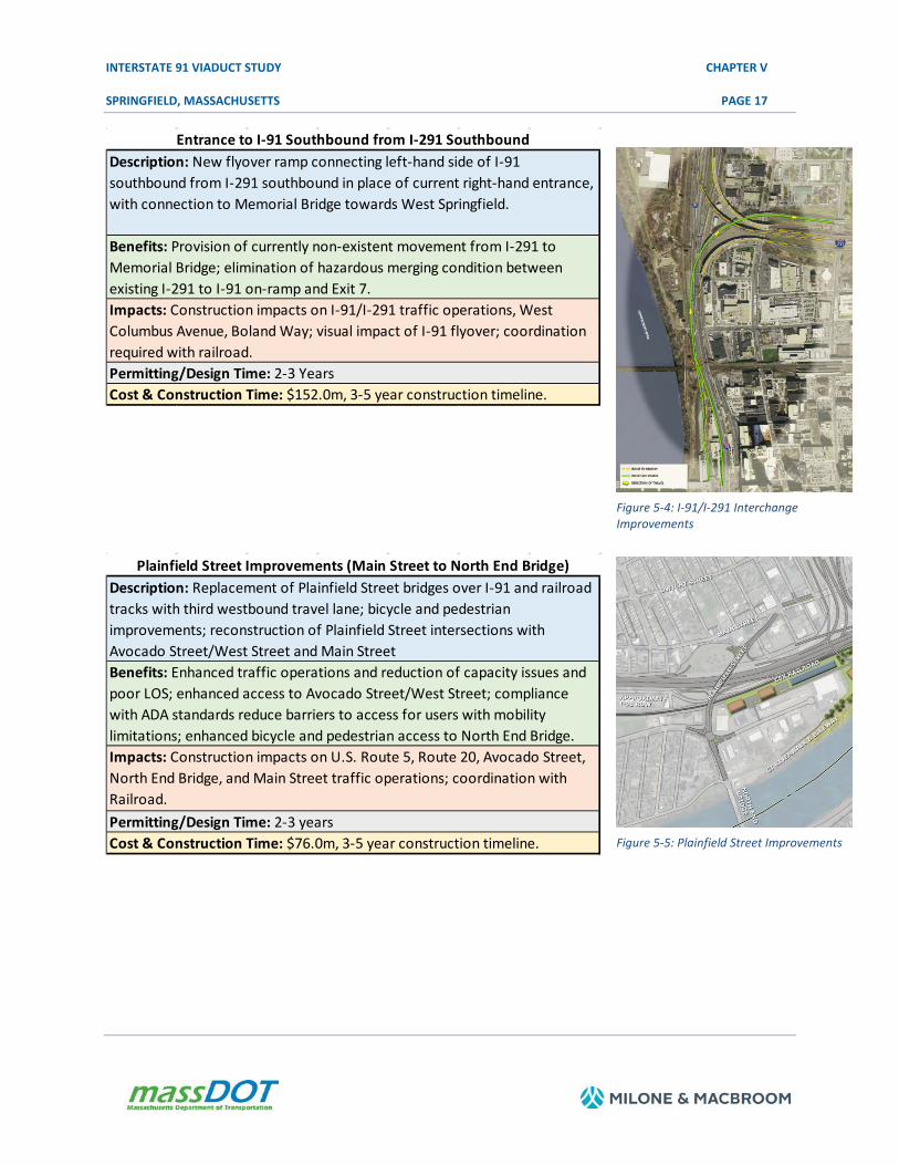
Entrance to I-91 Southbound from I-291 Southbound Description: New flyover ramp connecting left-hand side of I-91 southbound from I-291 southbound in place of current right-hand entrance, with connection to Memorial Bridge towards West Springfield.
Benefits: Provision of currently non-existent movement from I-291 to Memorial Bridge; elimination of hazardous merging condition between existing I-291 to I-91 on-ramp and Exit 7. Impacts: Construction impacts on I-91/I-291 traffic operations, West Columbus Avenue, Boland Way; visual impact of I-91 flyover; coordination required with railroad. Permitting/Design Time: 2-3 Years Cost & Construction Time: $152.0m, 3-5 year construction timeline.
Figure 5-4: I-91/I-291 Interchange Improvements
Plainfield Street Improvements (Main Street to North End Bridge) Description: Replacement of Plainfield Street bridges over I-91 and railroad tracks with third westbound travel lane; bicycle and pedestrian improvements; reconstruction of Plainfield Street intersections with Avocado Street/West Street and Main Street Benefits: Enhanced traffic operations and reduction of capacity issues and poor LOS; enhanced access to Avocado Street/West Street; compliance with ADA standards reduce barriers to access for users with mobility limitations; enhanced bicycle and pedestrian access to North End Bridge. Impacts: Construction impacts on U.S. Route 5, Route 20, Avocado Street, North End Bridge, and Main Street traffic operations; coordination with Railroad. Permitting/Design Time: 2-3 years Cost & Construction Time: $76.0m, 3-5 year construction timeline. Figure 5-5: Plainfield Street Improvements

INTERSTATE 91 VIADUCT STUDY CHAPTER V
SPRINGFIELD, MASSACHUSETTS PAGE 18
Connecticut Riverwalk and Bikeway - Forest Park Connection Description: Installation of bike and pedestrian connection bridge from the Connecticut Riverwalk and Bikeway over I-91 to Forest Park. Benefits: Enhanced safety and accessibility for pedestrians and bicylists; compliance with ADA standards reduce barriers to access for users with mobility limitations; greater potential utilization of existing recreational assets. Impacts: Potential minor land takings/easements Permitting/Design Time: 2-3 Year Cost & Construction Time: $19.75m (contingent on Longmeadow Curve mid-term improvements), 2-3 year construction timeline.
5.3.3 NEAR- AND MID-TERM RECOMMENDATIONS
It is recommended that the near- and mid-term projects described above be implemented, either as stand-alone projects or in logical groups, dependent upon current project needs and available or programmed funding opportunities. As this study progressed and each alternative, as well as the near- and mid-term projects, were formulated, care was taken to allow for these projects to be considered as stand-alone projects. This study, therefore, has provided cost and conceptual schedules for these significant improvement projects that can be considered in light of the recommendation that the No-Build alternative is an appropriate path forward for Springfield and the region.
Conceptual time lines and budgets provided for these projects could vary significantly and are dependent upon several factors, including but not limited to available funding, community support and priorities, and feasibility of combining individual improvements into coordinated projects.

INTERSTATE 91 VIADUCT STUDY CHAPTER V
SPRINGFIELD, MASSACHUSETTS PAGE 19
5.4 IMPLEMENTATION
5.4.1 MASSDOT PROJECT DEVELOPMENT AND DESIGN PROCESS
Development of transportation improvements is a complex decision-making process, with many stakeholders, decision makers, and reviewing agencies involved throughout the project development process. All projects developed by or with the involvement of the MassDOT Highway Division are guided by the eight-step process outlined in Chapter 2 of the MassDOT Highway Division's Project Development and Design Guide. This process guides a proposed transportation improvement from concept through construction and is designed to ensure that projects meet their stated goals and objectives.
This project development process is a requirement for all projects involving the MassDOT Highway Division, including projects in which the Highway Division is the project proponent, is responsible for project funding, or controls the infrastructure in question (projects on state highways). In the case of projects involving roadways or other infrastructure and property under the jurisdiction of the City of Springfield, Town of Agawam, Town of Longmeadow, or Town of West Springfield, project development and implementation are the responsibility of the municipality having jurisdiction. Examples of recommendations falling under municipal jurisdiction include local roads and signalization improvements, sidewalk/ADA improvements, public plazas, and drainage and utility upgrades.
The eight major steps that constitute the MassDOT Project Development and Design Process are outlined below and range from the first steps of identifying a project need toward greater refinement of the project's focus, design details, and ultimately toward implementation. The first two steps, Needs Identification and Planning, are addressed in the Interstate 91 Viaduct Study.
Step 1: Needs Identification
For each of the locations at which an improvement is to be implemented, MassDOT leads an effort to define the problem, establishes project goals and objectives, and defines the scope of the planning needed for implementation. To that end, it has to complete a Project Need Form (PNF), which states in general terms the deficiencies or needs related to the transportation facility or location. The PNF documents the problems and explains why corrective action is needed. For this study, the information defining the need for the project would be drawn primarily from the Interstate 91 Viaduct Study. At this point in the process, MassDOT also meets with potential participants, such as the Metropolitan Planning Organization (MPO) and community members, to allow for an informal review of the project.
The PNF is reviewed by the MassDOT Highway Division office whose jurisdiction includes the location of the proposed project. For the I-91 Viaduct, this is the District 2 office. MassDOT also sends the PNF to the MPO for informational purposes. The outcome of this step determines whether the project requires further planning, whether it is already well supported by prior planning studies, and therefore whether it is ready to move forward into the design phase or whether it should be dismissed from further consideration.

INTERSTATE 91 VIADUCT STUDY CHAPTER V
SPRINGFIELD, MASSACHUSETTS PAGE 20
Step 2: Planning
This phase would likely not be required for the implementation of the improvements proposed in the Interstate 91 Viaduct Study as this study should constitute the outcome of this step. However, the purpose of this implementation step is for the project proponent to identify issues, impacts, and approvals that may need to be obtained so that the subsequent design and permitting processes are understood.
The level of planning needed varies widely based on the complexity of the project. Typical tasks include the following: define the existing context, confirm the project need, establish goals and objectives, initiate public outreach, define the project, collect data, develop and analyze alternatives, make recommendations, and provide report documentation. Likely outcomes include consensus on the project definition to enable it to move forward into environmental documentation (if needed) and design or a recommendation to delay the project or dismiss it from further consideration.
Step 3: Project Initiation
At this point in the process, the proponent, MassDOT Highway Division, completes a Project Initiation Form (PIF) for each improvement, which is reviewed by its Project Review Committee (PRC) and the MPO, in this case the Pioneer Valley MPO. The PRC is composed of the Chief Engineer, each District Highway Director, representatives of the Project Management, Environmental, Planning, Right-of-Way, Traffic, and Bridge Departments, and the Federal Aid Program Office (FAPO). The PIF documents the project type and description, summarizes the project planning process, identifies likely funding and project management responsibility, and defines a plan for interagency and public participation. First, the PRC reviews and evaluates the proposed project based on the MassDOT's statewide priorities and criteria. If the result is positive, MassDOT Highway Division moves the project forward to the design phase and to programming review by the MPO. The PRC may provide a Project Management Plan to define roles and responsibilities for subsequent steps. The MPO review includes project evaluation based on the MPO's regional priorities and criteria. The MPO may assign a project evaluation criteria score, a Transportation Improvement Program (TIP) year, a tentative project category, and a tentative funding category.
Given transportation funding constraints, prioritization of the recommendations for implementation will need to be established regionally by the Pioneer Valley MPO, Pioneer Valley Planning Commission (PVPC), member communities, and MassDOT, in particular for the mid-term improvements recommended in section 5.3.2 above.
Step 4: Environmental Permitting, Design, and Right-of-Way Process
This step has four distinct but closely integrated elements: Public Outreach, Environmental Documentation and Permitting (varying levels, if required), Design, and Right-of-Way Acquisition (if required). The outcome of this step is a fully designed and permitted project ready for construction.

INTERSTATE 91 VIADUCT STUDY CHAPTER V
SPRINGFIELD, MASSACHUSETTS PAGE 21
The sections below provide more detailed information on the four elements of this step of the project development process.
Public Outreach: Continued public outreach in the design and environmental process is essential to maintain public support for the project and to seek meaningful input on the design elements. The public outreach is often in the form of required public hearings (conducted at the 25 percent and 100 percent design milestones) but can also include less formal dialogue with those interested in and affected by a proposed project.
Environmental Documentation and Permitting: The project proponent, in coordination with the Environmental Services section of the MassDOT Highway Division, will be responsible for identifying and complying with all applicable federal, state, and local environmental laws and requirements. This includes determining the appropriate project category for both the Massachusetts Environmental Protection Act (MEPA) and the National Environmental Protection Act (NEPA). Environmental documentation and permitting are often completed in conjunction with the Preliminary Design phase described below.
Design: There are three major phases of design. The first is Preliminary Design, also referred to as the 25 percent submission. The major components of this phase include a full survey of the project area, preparation of base plans, development of basic geometric layout, development of preliminary cost estimates, and submission of a functional design report. Preliminary Design, although not required to, is often completed in conjunction with Environmental Documentation and Permitting.
The next Phase is Final Design, which is also referred to as the 75 percent and 100 percent submission. The major components of this phase include preparation of a subsurface exploratory plan (if required), coordination of utility relocations, development of temporary traffic control plans through construction zones, development of final cost estimates, and refinement and finalization of the construction plans. Once Final Design is complete, a full set of Plans, Specifications, and Estimates (PS&E) is developed for the project.
Right-of-Way Acquisition: A separate set of Right-of-Way plans is required for any project that requires land acquisition or easements. The plans must identify the existing and proposed layout lines, easements, property lines, names of property owners, and the dimensions and areas of estimated takings and easements.
Step 5: Programming (Identification of Funding)
Programming, which typically begins during the design phase, can actually occur at any time during the process, from planning to design. In this step, which is distinct from project initiation, the project
INTERSTATE 91 VIADUCT STUDY CHAPTER V
SPRINGFIELD, MASSACHUSETTS PAGE 22
proponent requests that the MPO include a project from the Regional Transportation Plan in the region's annual TIP development process. The proponent requesting the project's listing on the TIP can be the community or one of the MPO member agencies (the Regional Planning Agency, MassDOT, or the Regional Transit Authority). The MPO considers the project in terms of state and regional needs, funding availability, project readiness, evaluation criteria, and compliance with the Regional Transportation Plan. If the MPO decides to include the project in the TIP, it is first included in the Draft TIP for public review and then in the Final TIP. A project does not have to be fully designed for the MPO to program it in the TIP, but generally a project has reached 75 percent design to be programmed in the year-one element of the four-year TIP.
Step 6: Procurement
Following project design and programming of a highway project, the MassDOT Highway Division publishes a request for proposals, which is also often referred to as being "advertised‟ for construction. MassDOT then reviews the bids and awards the contract to the qualified bidder with the lowest bid.
Step 7: Construction
After a construction contract is awarded, MassDOT Highway Division and the contractor develop a public participation plan and a temporary traffic control plan for the construction process.
Step 8: Project Assessment
The purpose of this step is to receive constituents' comments on the project development process and the project's design elements. MassDOT Highway Division can apply what is learned in this process to future projects.
Table 5-2 below summarizes the Project Development and Design Process steps detailed above, along with their effect on the project schedule and typical durations associated with each step.

INTERSTATE 91 VIADUCT STUDY CHAPTER V
SPRINGFIELD, MASSACHUSETTS PAGE 23
Table 5-2: Project Development Summary
Description Schedule Influence Typical Duration
Step 1: Needs Identification The proponent completes a Project Need Form (PNF). This form is then reviewed by the MassDOT District office, which provides guidance to the proponent on the subsequent steps of the process.
The PNF has been developed so that it can be prepared quickly by the proponent, including any supporting data that is readily available. The District office shall return comments to the proponent within one month of PNF submission.
1 to 3 months
Step 2: Planning Project planning can range from agreement that the problem should be addressed through a clear solution to a more detailed analysis of alternatives and their impacts.
For some projects, no planning beyond preparation of the PNF is required while other projects require a planning study centered on specific project issues associated with the proposed solution or a narrow family of alternatives. More complex projects would likely require a detailed alternatives analysis.
Project Planning Report: 3 to 24+ months
Step 3: Project Initiation The proponent prepares and submits a Project Initiation Form (PIF) and a Transportation Evaluation Criteria (TEC) form in this step. The PIF and TEC are informally reviewed by the Metropolitan Planning Organization (MPO) and MassDOT District office and formally reviewed by the Project Review Committee (PRC).
The PIF includes refinement of the preliminary information contained in the PNF. Additional information summarizing the results of the planning process, such as the Project Planning Report, is included with the PIF and TEC. The schedule is determined by PRC staff review (dependent on project complexity) and meeting schedule.
1 to 4 months
Step 4: Design, Environmental, and Right of Way The proponent completes the project design. Concurrently, the proponent completes necessary environmental permitting analyses and files applications for permits. Any right-of-way needed for the project is identified, and the acquisition process begins.
The schedule for this step is dependent upon the size of the project and the complexity of the design, permitting, and right-of-way issues. Design review by the MassDOT District and appropriate sections is completed in this step.
3 to 48+ months

INTERSTATE 91 VIADUCT STUDY CHAPTER V
SPRINGFIELD, MASSACHUSETTS PAGE 24
Description Schedule Influence Typical Duration
Step 5: Programming The MPO considers the project in terms of its regional priorities and determines whether or not to include the project in its Draft Transportation Improvement Program (TIP), which is then made available for public comment. The TIP includes a project description and funding source.
The schedule for this step is subject to each MPO's programming cycle and meeting schedule. It is also possible that the MPO would not include a project in its Draft TIP based on its review and approval procedures.
3 to 12+ months
Step 6: Procurement The project is advertised for construction and a contract awarded.
Administration of competing projects can influence the advertising schedule.
1 to 12 months
Step 7: Construction The construction process is initiated including public notification and any anticipated public involvement. Construction continues to project completion.
The duration of this step is entirely dependent upon project complexity and phasing.
3 to 60+ months
Step 8: Project Assessment The construction period is complete, and project elements and processes are evaluated on a voluntary basis.
The duration for this step is dependent upon the proponent's approach to this step and any follow-up required.
1 month
Source: MassDOT Highway Division Project Development and Design Guide
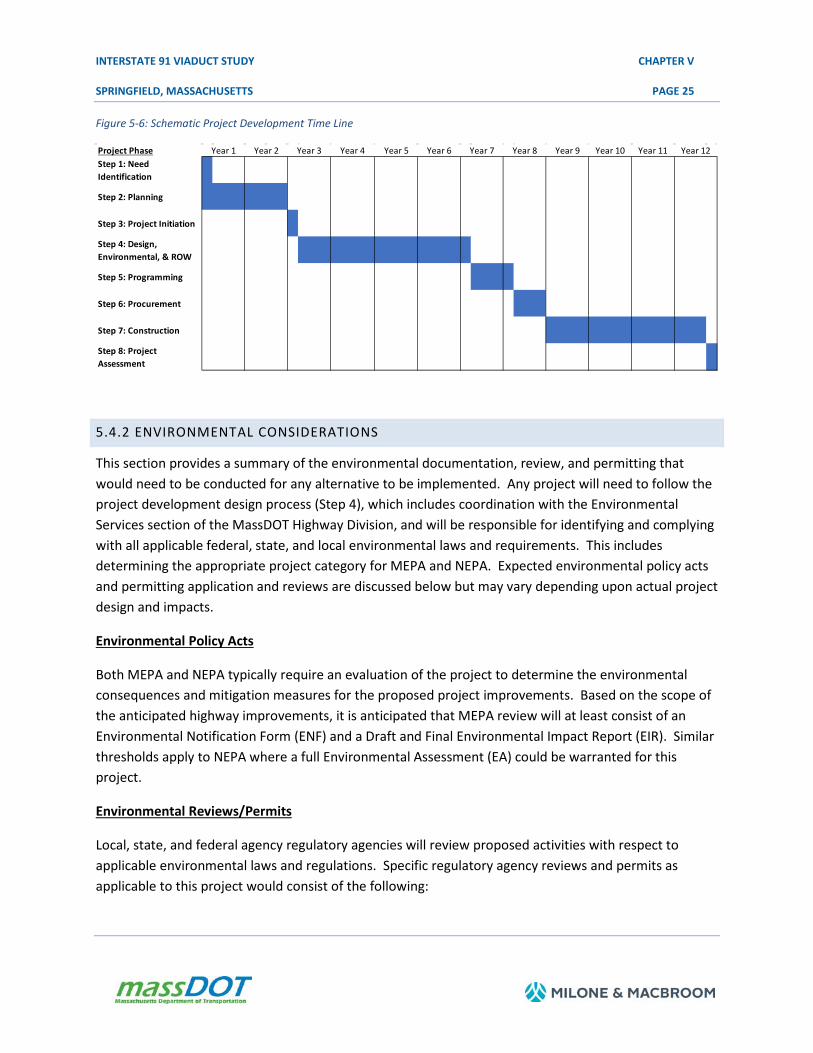
The project development process described previously is based on a conventional project delivery method, commonly referred to as "Design-Bid-Build" (D-B-B). The essence of the D-B-B process is that the project is designed to the PS&E level and then advertised for construction, i.e., the design and construction are carried out sequentially. Under this scenario, the engineer of record (designer) and the construction contractor are two separate contracting entities. A schematic time line illustrating this process, shown in the below figure, and for the purpose of this discussion assumes aggressive durations and that construction funding would be available at the end of the design phase.
INTERSTATE 91 VIADUCT STUDY CHAPTER V
SPRINGFIELD, MASSACHUSETTS PAGE 25
Figure 5-6: Schematic Project Development Time Line
5.4.2 ENVIRONMENTAL CONSIDERATIONS
This section provides a summary of the environmental documentation, review, and permitting that would need to be conducted for any alternative to be implemented. Any project will need to follow the project development design process (Step 4), which includes coordination with the Environmental Services section of the MassDOT Highway Division, and will be responsible for identifying and complying with all applicable federal, state, and local environmental laws and requirements. This includes determining the appropriate project category for MEPA and NEPA. Expected environmental policy acts and permitting application and reviews are discussed below but may vary depending upon actual project design and impacts.
Environmental Policy Acts
Both MEPA and NEPA typically require an evaluation of the project to determine the environmental consequences and mitigation measures for the proposed project improvements. Based on the scope of the anticipated highway improvements, it is anticipated that MEPA review will at least consist of an Environmental Notification Form (ENF) and a Draft and Final Environmental Impact Report (EIR). Similar thresholds apply to NEPA where a full Environmental Assessment (EA) could be warranted for this project.
Environmental Reviews/Permits
Local, state, and federal agency regulatory agencies will review proposed activities with respect to applicable environmental laws and regulations. Specific regulatory agency reviews and permits as applicable to this project would consist of the following:
Project Phase Year 4 Year 5 Year 6 Year 9 Year 10 Year 11Step 1: Need Identification
Step 2: Planning
Step 3: Project Initiation
Step 4: Design, Environmental, & ROW
Step 5: Programming
Step 6: Procurement
Step 7: Construction
Step 8: Project Assessment
Year 12Year 1 Year 2 Year 3 Year 7 Year 8

INTERSTATE 91 VIADUCT STUDY CHAPTER V
SPRINGFIELD, MASSACHUSETTS PAGE 26
• Massachusetts Wetlands Protection Act (WPA) – Wetlands Notice of Intent (NOI) • Section 401 of the Federal Clean Water Act – 401 Water Quality Certification • National Pollutant Discharge Elimination System (NPDES) Remediation General Permit • Environmental Protection Agency (EPA) Construction Stormwater General Permit • Section 404 Permit – U.S. Army Corps of Engineers (USACE) General Permit • Massachusetts Natural Heritage Estimated and Priority Habitats • Massachusetts Historical Commission (MHC) • Massachusetts General Law Chapter 21E and the Massachusetts Contingency Plan (MCP)
5.4.3 IMPLEMENTATION SUMMARY
As part of this study, several near- and mid-term improvement projects have been outlined. It is recommended that all of these improvements should be considered for project development. It is imperative that municipal leadership from Springfield, Agawam, Longmeadow, and West Springfield, as well as members of the broader community, PVPC, and MassDOT, continue to coordinate and further define the most appropriate and urgent projects. In addition, continued support from local and regional stakeholders in advancing high-priority projects is critical to successfully implementing this agenda. These local priorities should inform time lines and programming for each improvement to proceed to project development.
3869-16-6-au1518-rpt-chapter5.docx