Embed Size (px)
Citation preview

INTO THE FUTURE AN OVERVIEW OF THE EUMETSAT
SATELLITE PROGRAMMES
Kenneth Holmlund EUMETSAT
And many other contributors from EUMETSAT and its partners

2 JPSS Science Team Meeting 2015
METOP -A and -B (LOW-EARTH, SUN – SYNCHRONOUS ORBIT) EUMETSAT POLAR SYSTEM/INITIAL JOINT POLAR SYSTEM
JASON-2 (LOW-EARTH, 63° INCL. NON SYNCHRONOUS ORBIT) OCEAN SURFACE TOPOGRAPHY MISSION
METEOSAT SECOND GENERATION -8.-9.-10, MSG-4 (-11) (GEOSTATIONARY ORBIT) TWO-SATELLITE SYSTEM: - MSG-4 (METEOSAT-11) under commissioning - METEOSAT-10: FULL DISK IMAGERY MISSION AT 0° (15 MN) - METEOSAT-9: RAPID SCAN SERVICE OVER EUROPE AT 9.5°E (5 MN) - METEOSAT- 8: BACK UP AT 3.5°E
METEOSAT – 7 (1st GENERATION) (GEOSTATIONARY ORBIT) INDIAN OCEAN DATA COVERAGE MISSION AT 57°5 E (UNTIL END 2016)
Current EUMETSAT satellite fleet

3 JPSS Science Team Meeting 2015
EUMETSAT programmes overview 03 04 05 06 07 08 09 10 11 12 13 14 15 16 17 18 19 20 21 22 23 24 25 26 27 28 29 30 31 32 33 34 35 36 37 38 39 40 YEAR...
METEOSAT FIRST GENERATION
METEOSAT SECOND GENERATION
METEOSAT THIRD GENERATION
EUMETSAT POLAR SYSTEM (EPS)
METEOSAT-7
METEOSAT-8 METEOSAT-9
METEOSAT-10 MSG-4/METEOSAT-11 ……………..
MTG-I-1 : IMAGERY MTG-S-1: SOUNDING
MTG-I-2: IMAGERY MTG-I-3: IMAGERY
MTG-S-2: SOUNDING MTG-I-4: IMAGERY METOP-A
METOP-B METOP-C
METOP SECOND GENERATION METOP-SG-A1
JASON JASON-2
JASON-3 JASON CONTINUITY OF SERVICE (JASON-CS)
COPERNICUS SENTINEL-3
SENTINEL-4 ON MTG-S SENTINEL-5 ON EPS-SG
03 04 05 06 07 08 09 10 11 12 13 14 15 16 17 18 19 20 21 22 23 24 25 26 27 28 29 30 31 32 33 34 35 36 37 38 39 40
Mandatory Programmes
Optional and Third Party Programmes
YEAR...
METOP-SG-B1 METOP-SG-A2
METOP-SG-B2 METOP-SG-A3
METOP-SG-B3 Operational Development
…Extended lifetime .............. …Extended lifetime ..............
…Extended lifetime ..............
…Extended lifetime ...
…Extended lifetime ........................................ …Extended lifetime ...........................................

4 JPSS Science Team Meeting 2015
Future programmes shape the 2018 – 2040 timeframe
Jason-CS/Sentinel-6: Approval process ongoing
EPS-SG: Approved, under development Sentinel-5 approved (funded by Copernicus)
MTG: Approved, under development Sentinel-4 approved (funded by Copernicus)

5 JPSS Science Team Meeting 2015
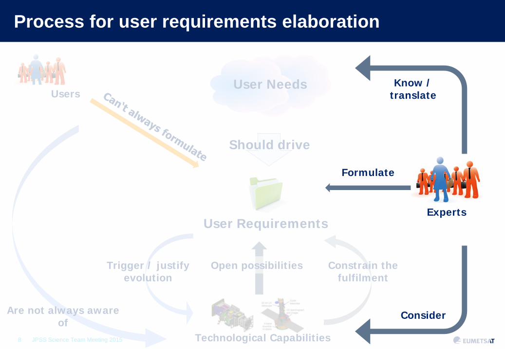
Process for user requirements elaboration
User Needs
User Requirements
Should drive
5

6 JPSS Science Team Meeting 2015
User Needs
User Requirements
Should drive
Process for user requirements elaboration
Are not always aware of
Users
6

7 JPSS Science Team Meeting 2015
Are not always aware of
Users User Needs
User Requirements
Should drive
Process for user requirements elaboration
Technological Capabilities
Trigger / justify evolution
Constrain the fulfilment
Open possibilities
7
8 JPSS Science Team Meeting 2015 Technological Capabilities
Trigger / justify evolution
Constrain the fulfilment
Open possibilities
Are not always aware of
Users User Needs
User Requirements
Should drive
Process for user requirements elaboration
Experts
Consider
Know / translate
Formulate
8

9 JPSS Science Team Meeting 2015
Experts
Consider
Know / translate
Formulate
Technological Capabilities
Trigger / justify evolution
Constrain the fulfilment
Open possibilities
Are not always aware of
Users User Needs
User Requirements
Should drive
Process for user requirements elaboration
User Workshop
Guide
Discuss / endorse
9

10 JPSS Science Team Meeting 2015
User Workshop
Guide
Discuss / endorse Experts
Consider
Know / translate
Formulate
Technological Capabilities
Trigger / justify evolution
Constrain the fulfilment
Open possibilities
Are not always aware of
Users User Needs
User Requirements
Should drive
Process for user requirements elaboration
10
Approves
user list

11 JPSS Science Team Meeting 2015
Process for user requirements elaboration
User Needs
User Requirements
Should drive
Are not always aware of
Users
Technological Capabilities
Trigger / justify evolution
Constrain the fulfilment
Open possibilities
Experts
Consider
Know / translate
Formulate
User Workshop
Guide
Discuss / endorse
Approves
user list
11

12 JPSS Science Team Meeting 2015
Post-EPS Application Experts Groups
AEG Sounding & Wind
AEG Clouds, Precip, Land
AEG Ocean-ography
AEG Climate monitoring
AEG Atmosph. Chemistry
Composition-climate
Ozone & UV
Air quality
Global
Coastal
Post-EPS user requirements
Other user requirements (WMO, IGOS + others)
AEG expertise
MTG user requirements for NWP global
MTG user requirements for NWP regional
MTG user requirements for NWC
INPUT TO AEGs
∆t > 1 hour

13 JPSS Science Team Meeting 2015
1=VIS0.6
2=WV6.2
3=IR10.8
12=HRV
From MVIRI on MTP...
Slide: 13
Meteosat-7 is the last Located over - Indian Ocean Operational - until end of 2016

14 JPSS Science Team Meeting 2015
1=VIS0.6 2=VIS0.8
3=NIR1.6
4=IR3.8 5=WV6.2 6=WV7.3 7=IR8.7
8=IR9.7 9=IR10.8 10=IR12.0 11=IR13.4
12=HRV
Slide: 14
From MVIRI on MTP to SEVIRI on MSG...
MSG-4 (Meteosat-11) - is the last - in-orbit storage 2.5 y Indian Ocean Data - coverage is considered using Meteosat-8 Operational programme - until 2025 (TBC)

15 JPSS Science Team Meeting 2015
3=VIS0.6 4=VIS0.8
7=NIR1.6
9=IR3.8 10=WV6.2 11=WV7.3 12=IR8.7
13=IR9.7 14=IR10.5 15=IR12.3 16=IR13.3
1=VIS0.4 2=VIS0.5 5=NIR0.9 6=NIR1.3
8=NIR2.2
From MVIRI through SEVIRI to FCI on MTG
Slide: 15

16 JPSS Science Team Meeting 2015
Visual Analysis: Monitoring Stages of Convection
23. September 2009 Mediterranean Sea
“Sandwich Product”
HRV 0.6 µm 0.8 µm 1.6 µm
3.9 µm 6.2 µm 7.3 µm 8.7 µm
9.7 µm 10.8 µm 12.0 µm 13.4 µm

17 JPSS Science Team Meeting 2015
Visual Analysis: Monitoring Stages of Convection
“Sandwich Product”
HRV 0.6 µm 0.8 µm 1.6 µm
3.9 µm 6.2 µm 7.3 µm 8.7 µm
9.7 µm 10.8 µm 12.0 µm 13.4 µm

18 JPSS Science Team Meeting 2015
Met-8 super-rapid scans 2.5 min experiment
15 minutes Repeat Cycle
5 minutes Repeat Cycle
2.5 minutes Repeat Cycle

19 JPSS Science Team Meeting 2015
Imagery mission implemented by a two-satellite MTG-I system:
1. Full disk imagery every 10 minutes in 16 spectral bands
2. Fast imaging of European weather every 2.5 minutes
3. Lightning Imager (LI)
Hyperspectral Infrared (IRS) Sounding mission:
4. 3D mapping of water vapour, temperature, O3 every 1 hour
5. Air quality monitoring and atmospheric chemistry in synergy with Sentinel-4 Ultraviolet Visible
start of operations in 2019 and 2021
operational exploitation: 2019– 2040
Meteosat Third Generation: Mission overview

20 JPSS Science Team Meeting 2015
LI reference processor development – product example
“Accumulated flash area” product, integrated over 15 minutes and updated every 30 seconds
Date: 20 June 2013.

21 JPSS Science Team Meeting 2015
H2O(p) CO T(p) Sfc O3 Sfc
Temp (CO2)
Surface, Clouds
O3
Surface, Clouds
H2O, CH4, N2O
CO
N2O, Temp (CO2)
Temp (CO2)
Surface, Clouds
700 – 1210 cm-1 1600 – 2175 cm-1
MTG Mission: InfraRed Sounder (IRS)
MTG-IRS will deliver unprecedented information on horizontal and vertical gradients of moisture, wind and temperature from the geostationary orbit: Full Disk Sounding; Repeat Cycle = 60 min; spatial resolution of 4 km, hyperspectral soundings at 0.625 cm-1 spectral sampling in two bands:
Long-Wave-IR (LWIR: 700 – 1210 cm-1 ~820 spectral samples) Mid-Wave-IR (MWIR: 1600 – 2175 cm-1 ~920 spectral samples)

22 JPSS Science Team Meeting 2015
MTG Mission: hosting GMES Sentinel-4 The GMES Sentinel-4 sounding
mission is achieved through the Ultraviolet, Visible & Near-infrared (UVN) Instrument accommodated on the MTG-S satellites covering Europe every hour taking measurements in three spectral
bands (UV: 305 - 400 nm; VIS: 400 - 500 nm, NIR: 750 - 775 nm)
with a resolution around 8km.
The primary data products are O3, NO2, SO2, HCHO and aerosol optical depth.
O3, CO, NO2, SO2, VOC(H2CO, CHOCHO), Aerosol/PM
MTG-IRS
GMES S4-UVN
MTG-LI MTG-FCI
Synergies of missions flying on MTG

23 JPSS Science Team Meeting 2015
EUMETSAT Polar System Programme
Slide: 23 EUM/LEO/VWG/11/0587, EPS Day, 7th September 2011
- Metop-A launched in 2006 - Metop-B launched in 2012 - Metop-C launch scheduled for 2019 - Sun Synchronous orbit - 820 km, 9h30 LST,100 min - Sole source of mid-morning orbit data - 11 Instruments - Soyuz Launcher Service (Baikonur/Kourou) - ESOC LEOP Service (Darmstadt) - Central & distributed Ground Segment components - 14+ years of operations
Metop-A
Metop-B
Metop-C
Polar Stations Svalbard, 78 deg North
EUMETSAT Mission Control Centre
Launcher Service (Soyuz, Baikonur)
LEOP Service (ESOC)
Satellite Application Facilities (SAF) 8 Meteorological Themes

24 JPSS Science Team Meeting 2015
The EUMETSAT polar system as part of the initial joint polar system shared with the US
• Coordinated programmes • Exchange of instruments • Coordinated operations, data and services • Only Metop provides mid-morning service •And now China has committed to the early morning orbit

25 JPSS Science Team Meeting 2015
Current Capabilities - EUMETSAT Polar System
GOME-2 Global Ozone
Monitoring Experiment
GRAS GPS Receiver for Atmospheric Sounding AVHRR
Advanced Very High Resolution Radiometer
HIRS/4 High-resolution Infrared Radiation Sounder
IASI Infrared Atmospheric Sounding Interferometer
AMSU-A1 Advanced Microwave Sounding Unit-A1
MHS Microwave Humidity Sounder ASCAT
Advanced SCATterometer
AMSU-A2 Advanced Microwave
Sounding Unit-A2

26 JPSS Science Team Meeting 2015
Aerosol: PMAp (GOME-2 + AVHRR) Metop A & B combined
AOD (PMAp – METOP A & B)
Ocean = Operational retrieval Land = test retrieval in development

27 JPSS Science Team Meeting 2015
Metop-B is in the same orbital plane as Metop-A
Metop-A
Metop-B
Metop-A
Morning Orbit Equator crossing time: 09:30 LST Orbit phasing: 48.93 min.
Metop-C in 2018

28 JPSS Science Team Meeting 2015
Dual Metop
Metop winds over South Pole (QI>80)
Dual Metop winds: Global coverage and quality improvement in polar regions
One Metop
Global dual Metop winds

29 JPSS Science Team Meeting 2015
EUMETSAT dual Metop winds: Global coverage
Bin size = 80x80 km2

30 JPSS Science Team Meeting 2015
EPS Second Generation
Primary mission: further improve observational inputs to Numerical Weather Prediction models
Significant contributions to other real time applications:
Nowcasting at high latitudes Marine meteorology and operational oceanography Operational hydrology Air quality monitoring
Climate monitoring: expand by 20+ years the climate data records
initiated in 2006 with EPS

31 JPSS Science Team Meeting 2015
EPS Second Generation
Continuation and enhancement of service from mid morning polar orbit in 2021 – 2040
Twin satellite in-orbit configuration:
Metop-SG A: optical imagery and sounding mission Flies the Copernicus Sentinel-5 instrument
Metop-SG B: microwave imaging mission
Two series of 3 successive satellites for 21 years of operations
European contribution to the Joint Polar System (JPS) shared with the US/NOAA

32 JPSS Science Team Meeting 2015
Satellites at a glance
METOP-SG-B
METOP-SG-A
EPS Second Generation

33 JPSS Science Team Meeting 2015
Distribution of Instruments per Satellite
EPS Second Generation Instruments’ Overview

34 JPSS Science Team Meeting 2015
EPS-SG Current Status
Achieved approval of the scope and contents of the EPS-SG Programme Proposal which includes the draft cooperation agreements with ESA, CNES, DLR and NOAA
Achieved in June 2015 approval of full EPS-SG programme from January 2016
onwards • System Preliminary Design Review (PDR) successfully completed in June 2015
• ESA: Prime contractors for the Metop-SG A and B satellites selected and Phase B2
kicked off in June 2014, PDR planned for September 2015
• CNES: IASI-NG PDR successfully completed in May 2015
CNES: The first flight model of A-DCS4 for EPS-SG is under assembly
DLR: METimage instrument PDR successfully completed in July 2015
EUM: Overall Ground Segment PDR planned for September 2015

36 JPSS Science Team Meeting 2015
MONITORING THE OCEAN IN SUPPORT OF COPERNICUS

37 JPSS Science Team Meeting 2015
Sentinel-3 Satellite and Payload
SLSTR: Sea and Land Surface
Temperature Radiometer
SRAL: Synthetic Aperture Radar Altimeter
OLCI: Ocean and Land Colour Instrument
MWR: Micro-Wave Radiometer
LRR: Laser Retro-Reflector
DORIS: Doppler Orbitography and Radiopositionning Integrated by Satellite
STM: Surface Topography Mission = SRAL + MWR

38 JPSS Science Team Meeting 2015
Sentinel-3 Marine product contents
Level 2 OLCI: • Normalised water surface reflectance • Algal pigment concentration for open and
for coastal waters • Total suspended matter concentration • Diffuse attenuation coefficient • Coloured dissolved matter absorption • Photosynthetically active radiation • Integrated water vapour • Aerosol optical depth • Aerosol Angström exponent
Level 2 SLTSR: • Sea surface temperature (L2P GHRSST standard)
Level 2 SRAL: • Sea/coastal zone surface height • Significant wave height • Wind speed • Backscatter coefficient σ0 • Sea ice height, freeboard • Total water, liquid water (from MWR)
Level 1B: SLTSR (radiance, BT at TOA) and OLCI (radiance at TOA) and SRAL(waveforms)
(ESA and EUMETSAT)

39 JPSS Science Team Meeting 2015
Combining Sentinel-3 & Jason altimetry for operational oceanography and climate change monitoring
(Courtesy CNES/CLS/ESA)
Sentinel 3 Jason-3 and Jason-CS/Sentinel 6
40 JPSS Science Team Meeting 2015
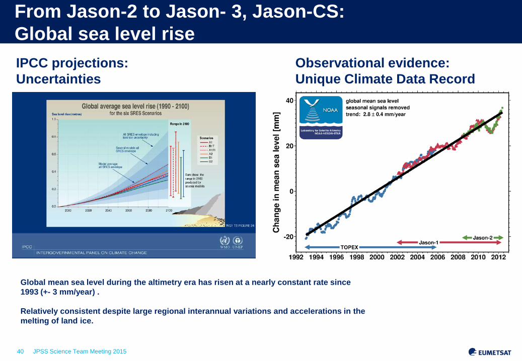
From Jason-2 to Jason- 3, Jason-CS: Global sea level rise IPCC projections: Uncertainties
Observational evidence: Unique Climate Data Record
Global mean sea level during the altimetry era has risen at a nearly constant rate since 1993 (+- 3 mm/year) . Relatively consistent despite large regional interannual variations and accelerations in the melting of land ice.

41 JPSS Science Team Meeting 2015
Why has the western Pacific risen 3 times faster? Why has sea level dropped near the U.S. West Coast? How will regional sea level change in the future?
Mean sea level trends : regional differences 1993 - 2012

42 JPSS Science Team Meeting 2015
PRODUCT STATUS AND SCIENCE MATURITY

43 JPSS Science Team Meeting 2015
Product Status
STATUS
DEMONSTRATIONAL PRE-OPERATIONAL OPERATIONAL
PRODUCT QUALITY
First version of the Product
Quality approaching to expected levels
Expected Quality (as per Requirements)
STATUS OF VALIDATION
PROCESS
Limited Validation performed
Validation almost completed (if not completed), with
documented limitations
Validation performed and fully documented
PRODUCT LIMITATIONS
Potentially unknown or Major
Known & Not Major or None
None or Known limitations agreed with
Users PRODUCT
DOCUMENTATION
Product Validation report & User manual Not
Available
Product Validation report & User manual (mainly)
completed
All completed, published and available
AUDIENCE
Internal Users + Investigators
Usually not more than a very limited set of users
Varying from ‘limited set of Users’ to ‘All
Registered Users’
Usually ‘All Registered Users’
(unless exceptions)
ACCESS BY EXTERNAL
USERS
No Access to the Documentation
Documentation on the WEB
Documentation on the WEB

44 JPSS Science Team Meeting 2015
CDR Maturity Matrix - Top Layer
CDR Name Here Maturity level as of
mm/dd/yyyy
Maturity Software Readiness Metadata Documentation Product Validation Public Access Utility
1 Conceptual development Little or none
Draft Climate Algorithm Theoretical Basis Document
(C-ATBD); paper on algorithm submitted
Little or None Restricted to a select few Little or none
2 Significant code changes expected Research grade C-ATBD Version 1+ ; paper
on algorithm reviewed Minimal Limited data availability to develop familiarity Limited or ongoing
3
Moderate code changes expected
Research grade; Meets int'l standards: ISO or FGDC for collection; netCDF for file
Public C-ATBD; Peer-reviewed publication on
algorithm
Uncertainty estimated for select locations/times
Data and source code archived and available;
caveats required for use.
Assessments have demonstrated positive value.
4 Some code changes expected
Exists at file and collection level. Stable. Allows
provenance tracking and reproducibility of dataset.
Meets international standards for dataset
Public C-ATBD; Draft Operational Algorithm
Description (OAD); Peer-reviewed publication on
algorithm; paper on product submitted
Uncertainty estimated over widely distributed
times/location by multiple investigators; Differences
understood.
Data and source code archived and publicly available; uncertainty
estimates provided; Known issues public
May be used in applications; assessments demonstrating
positive value.
5 Minimal code changes
expected; Stable, portable and reproducible
Complete at file and collection level. Stable.
Allows provenance tracking and reproducibility of
dataset. Meets international standards for dataset
Public C-ATBD, Review version of OAD, Peer-
reviewed publications on algorithm and product
Consistent uncertainties estimated over most
environmental conditions by multiple investigators
Record is archived and publicly available with associated uncertainty
estimate; Known issues public. Periodically updated
May be used in applications by other investigators;
assessments demonstrating positive value
6
No code changes expected; Stable and reproducible;
portable and operationally efficient
Updated and complete at file and collection level. Stable. Allows provenance tracking
and reproducibility of dataset. Meets current
international standards for dataset
Public C-ATBD and OAD; Multiple peer-reviewed
publications on algortihm and product
Observation strategy designed to reveal
systematic errors through independent cross-checks,
open inspection, and continuous interrogation;
quantified errors
Record is publicly available from Long-Term archive;
Regularly updated
Used in published applications; may be used by
industry; assessments demonstrating positive value

45 JPSS Science Team Meeting 2015
Maturity Matrix – Validation Layer Guideline
Maturity PRODUCT VALIDATION Independent validation Uncertainty (for TCDRs) Quality flag Operational monitoring
1 Little or None Incomplete Little or no information on biases and errors None Incomplete
2 Minimal Comparison to training set, test dataset, or previous product
Limited information on biases and errors
Data gaps identified or flagged as appropriate Incomplete
3 Uncertainty estimated for select locations/times
At least 1 comparison to models, in-situ data, or other indpendent
products as available and appropriate to particular CDR
Biases and errors identified and documented
Data gaps identified or flagged as appropriate; Masks applied as appropriate
(e.g., land masks, cloud masks) Incomplete
4
Uncertainty estimated over widely distributed
times/location by multiple investigators; Differences
understood.
At least 2 comparisons to models, in-situ data, or other indpendent
products as available and appropriate to particular CDR;
differences in results understood
Biases and errors quantified Masks applied as appropriate (e.g., land masks, cloud masks); algorithm failures
identified
Method for operational monitoring being developed
5
Consistent uncertainties estimated over most
environmental conditions by multiple investigators
At least 5 comparisons to models, in-situ data, or other indpendent
products as available and appropriate to particular CDR;
differences in results understood
Biases and errors minimized
Masks applied as appropriate (e.g., land masks, cloud masks); algorithm failures identified; instrument degradation flags
applied
Operational monitoring in place
6
Observation strategy designed to reveal
systematic errors through independent cross-checks,
open inspection, and continuous interrogation;
quantified errors
At least 10 comparisons to models, in-situ data, or other indpendent
products as available and appropriate to particular CDR;
observation strategy designed to reveal systematic errors through independent cross checks, open
inspection, and continuous interrogation
Biases and errors minimized
Masks applied as appropriate (e.g., land masks, cloud masks); algorithm failures identified; instrument degradation flags
applied. Additional flags or modification of flag algorithms as a result of additional
validation and user feedback
Operational monitoring in place with results fed back to quality
flags

46 JPSS Science Team Meeting 2015
As an example ERA-Interim
Maturity Software Readiness Metadata Documentation Product Validation Public Access Utility 1 Conceptual development Little or none Draft Climate Algorithm
Theoretical Basis Document (C-ATBD); paper on algorithm submitted
Little or None Restricted to a select few Little or none
2 Significant code changes expected
Research grade C-ATBD Version 1+ ; paper on algorithm reviewed
Minimal Limited data availability to develop familiarity
Limited or ongoing
3 Moderate code changes expected
Research grade; Meets int'l standards: ISO or FGDC for collection; netCDF for file
Public C-ATBD; Peer-reviewed publication on algorithm
Uncertainty estimated for select locations/times
Data and source code archived and available; caveats required for use.
Assessments have demonstrated positive value.
4 Some code changes expected Exists at file and collection level. Stable. Allows provenance tracking and reproducibility of dataset. Meets international standards for dataset
Public C-ATBD; Draft Operational Algorithm Description (OAD); Peer-reviewed publication on algorithm; paper on product submitted
Uncertainty estimated over widely distributed times/location by multiple investigators; Differences understood.
Data and source code archived and publicly available; uncertainty estimates provided; Known issues public
May be used in applications; assessments demonstrating positive value.
5 Minimal code changes expected; Stable, portable and reproducible
Complete at file and collection level. Stable. Allows provenance tracking and reproducibility of dataset. Meets international standards for dataset
Public C-ATBD, Review version of OAD, Peer-reviewed publications on algorithm and product
Consistent uncertainties estimated over most environmental conditions by multiple investigators
Record is archived and publicly available with associated uncertainty estimate; Known issues public. Periodically updated
May be used in applications by other investigators; assessments demonstrating positive value
6 No code changes expected; Stable and reproducible; portable and operationally efficient
Updated and complete at file and collection level. Stable. Allows provenance tracking and reproducibility of dataset. Meets current international standards for dataset
Public C-ATBD and OAD; Multiple peer-reviewed publications on algorithm and product
Observation strategy designed to reveal systematic errors through independent cross-checks, open inspection, and continuous interrogation; quantified errors
Record is publicly available from Long-Term archive; Regularly updated
Used in published applications; may be used by industry; assessments demonstrating positive value
5.083333 4.5 2 6 6 6 6
C-ATBD too restrictive Global reanalysis has more comparisons to observations than anyone else before using them (short forecast). Plus some datasets are withheld completely, yet compared with.

EUM/STG-SWG/35/13/VWG/14 12 – 13 September 2013 Slide 47
FP7 CORE-CLIMAX Establishing Common Practices for Climate Observations
Courtesy: John Bates (NOAA)
System Maturity Matrix Application Performance Matrix

EUM/STG-SWG/35/13/VWG/14 12 – 13 September 2013 Slide 48
Beta level Products intended to enable users to gain familiarity with the
parameters and the data formats Provisional Product was defined to facilitate data exploration and
process studies that do not require rigorous validation. These data are partially validated and improvements are continuing
Validated Stage 1-4 validated
NASA Data Maturity Levels
EUM/STG-SWG/35/13/VWG/14 12 – 13 September 2013 Slide 49
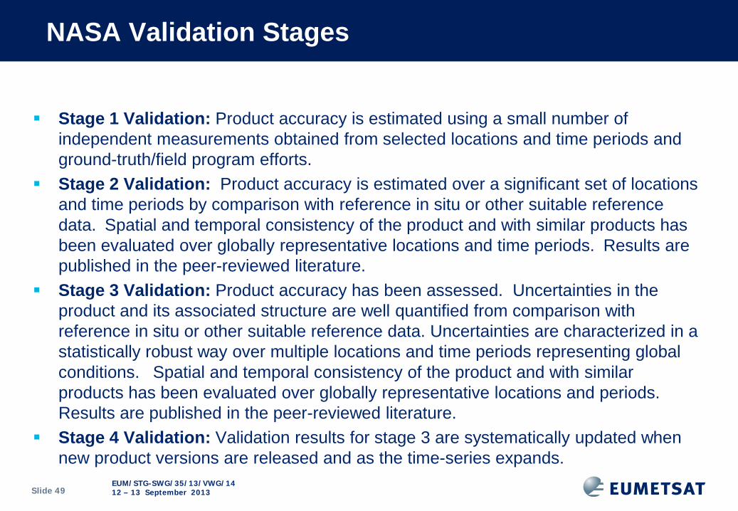
Stage 1 Validation: Product accuracy is estimated using a small number of independent measurements obtained from selected locations and time periods and ground-truth/field program efforts.
Stage 2 Validation: Product accuracy is estimated over a significant set of locations and time periods by comparison with reference in situ or other suitable reference data.Spatial and temporal consistency of the product and with similar products has been evaluated over globally representative locations and time periods.Results are published in the peer-reviewed literature.
Stage 3 Validation: Product accuracy has been assessed. Uncertainties in the product and its associated structure are well quantified from comparison with reference in situ or other suitable reference data. Uncertainties are characterized in a statistically robust way over multiple locations and time periods representing global conditions. Spatial and temporal consistency of the product and with similar products has been evaluated over globally representative locations and periods. Results are published in the peer-reviewed literature.
Stage 4 Validation: Validation results for stage 3 are systematically updated when new product versions are released and as the time-series expands.
NASA Validation Stages

50 JPSS Science Team Meeting 2015
Science Maturity Index (1/2)
Initiated by concepts developed for Climate data record Generation - (see e.g. Bates and Privette 2012) However, there are also significant technical aspects in the CDR
maturity model, whereas here we are trying to assess the scientific maturity of the centrally derived products
The proposed index is based on four major maturity categories: - Scientific Understanding - Modelling of the physical principals - Instrument capability and characterisation - Validation
All categories receive an estimate: 3= Highest achievable status, 2 = medium maturity and 1 =
initial/immature The Scientific Maturity Index = Sum of the estimates per category (Max = 12, Min = 4)

51 JPSS Science Team Meeting 2015
Science Maturity Index (2/2)
The purpose of the Index is to provide guidance on where efforts should be invested for future development.
It is considered a useful complementary dimension based on an agreed assessment methodology.
However, it is only one aspect that has to be considered. In addition the utility of the product for scientific application and exploitation
has to be considered. Should also aid setting the overall priorities wrt to available resources..

52 JPSS Science Team Meeting 2015
An example for Metop Level-1 data Product
Processing Facility (PPF)
Metop-A Status
Metop-B Status
Maturity Total (SU, M,
ICC, VAL)
Remarks
AVHRR Level 1 Operational Operational 12 (3,3,3,3) AMSU-A Level 1 Operational Operational 11 (3,3,2,3) Some channel out of
spec / failed
HIRS/4 Level 1 Operational Operational 11 (3,3,2,3) Some channels on Metop-B are at times out of specification
MHS Level 1 Operational Operational 12 (3,3,3,3) IASI Level 1 Operational Operational 12 (3,3,3,3) IASI L1 PCC Operational Operational 9 (3,2,2,2) ASCAT Level 1 Operational Operational 10 (3,2,2,3) GOME-2 Level 1 Operational Operational 11 (3,3,2,3) Metop-A operating
in 960km and Metop-B in 1920km swath mode.
GRAS Level 1 Operational Operational 9 (3,2,2,2) GO

53 JPSS Science Team Meeting 2015
Metop Level-2 Products (Derived at EUMETSAT HQ) PPF Product Status Maturity
Total (SU, M, ICC, VAL) Remarks
IASI temperature and humidity retrieval
Operational 11 (3,2,3,3)
IASI Ozone total column Operational 11 (3,3,3,2) IASI CO profiles Operational 10 (3,2,3,2) Validation on-going with
O3M SAF IASI trace gases (ozone profiles, N2O, CH4, CO2)
Demonstrational 7 (2,2,2,1) Development started for CH4
IASI surface emissivity Pre-operational 7 (2,2,2,1) IASI Cloud Parameters Operational 11 (3,3,2,3) IASI SST L2Pcore Operational 11 (3,3,3,2) ATOVS Level 2 Operational 12 (3,3,2,3) Some degradation for
Metop-A due to noisy or missing AMSU-A channels
ASCAT Soil Moisture Operational 8 (2,2,2,2) H-SAF product operated Polar Cap Winds from AVHRR Operational 9 (3,2,2,2) Global AVHRR Winds Operational 7 (3,2,1,1) Triplet AVHRR Winds Pre-operational 7 (3,2,1,1) Polar Multi-sensor Aerosol properties over sea
Operational 9 (3,2,2,2)
Polar Multi-sensor Aerosol (v2) including land
Pre-operational 8 (3,2,2,1) Validation on-going

54 JPSS Science Team Meeting 2015
Science Readiness Level - Another matrix approach Initial attempt (in coop with SAFs, DBs, ESA)– to be refined
SRL Name Associated documents
Theory / Model Observation Validation / Verification
User
1 Scientific Idea Scientific idea Non non define Application Area Interest from Users
2 Conceptual Technique Conceptual model, physical principal is clearly defined (no software is needed)
Gap analysis; complementary in observation system; uniqueness
Set high level draft EURD
3 Scientific / Observation Requirements
Mission proposal
Forward model is available (i.e. RTM simulation of measur.)
Initial capability assessment (Info content anal.)
Scientific requirements vs user requirements approved
4 Proof of concept MRD Consolidated approach 1st sim. obs are available
Simulated measurements
Consolidated EURD
5 End-to-end performance simulations
Stable MRD, E2E (End-to-end simulator)
Consolidated retrieval and draft ATBD (+ prototype) are available
Demonstrator (e.g. airborne instr) “real data”
Calibration and Validation Plan established
Final EURD Committed Beta-User (e.g. through AO call’s)
6 Consolidated science and products (end: launch of sat)
ATBD’s Final ATBD and operational processor / implementation
Pre-launch Test data and sampled data processing
User studies with simulated or pre-cursor data
7 Demonstrated science (commissioning phase)
In orbit characterisations; perf vs. spec (EURD)
CAL/VAL conducted,; Early release of data; beta /demo data ava.
User feedback (validation team)
8 Validated and matured science(sat declared op)
Science feedback
Full validation Operational validation and quality assurance via network
9 Science Impact quantification
Advancement in scientific understanding
User impact

55 JPSS Science Team Meeting 2015
Thank You Questions?