Embed Size (px)
Citation preview

Expert meeting on Marine Biodiversity and Eutrophication in the Northwest Pacific Region5 6 August 2013 Toyama Japan5-6 August, 2013, Toyama, JapanAgenda Item 6 - Seagrass
Introduction on Some Efforts on Optical Image Optimization in Limited Water Area for
Seagrass Information Extraction
Yongchao ZhaoYongchao Zhao
Institute of Electronics (IECAS)Chinese Academy of Sciences, Chinay ,
[email protected]+86-13501162025
+86 10 58887208 8703
8/22/2013
+86-10-58887208-8703

Outline
Background: limited/shallow coastal water area, seagrass/water/benthalBackground: limited/shallow coastal water area, seagrass/water/benthal
Our efforts: Method/Model/Software
Denoise and Destripe (SRSSHF+VRadCor)Denoise and Destripe (SRSSHF+VRadCor)Water Correction (WRC)Denegative for reflectanceWave removing and extractingSeagrass mapping
Current or future works: M th d/S ft /E i tCurrent or future works: Method/Software/Equipment
Precise water spectrum measurement: methods and toolsInformation response and extraction: model/algorithm/softwareInformation response and extraction: model/algorithm/softwareSignal fractionization: water, surface, seagrass/seaweed, seabed

Background: About us

Background: About us
Some works for water-seagrass remote sensing
Water-seagrass information transfer understanding and experimental
g g
validation
Precise water spectrum measurement: methods and equipments
Water image optimization: algorithm and software
Special water-seagrass information extraction: seagrass mapping, water
depth……
Project: CAS: water polarization spectrum featuresProject: CAS: water polarization-spectrum features
NASA: seagrass information extraction in Tampa Bay
HS2IS
field experiments with long-time water spectrum measurement: >100,000

BackgroundNASA ROSES-2008 (NNX09AT51G):NASA’s Earth science for decision making:S s sc e ce o dec s o g:Gulf of Mexico Region: “ Mapping andCharacterization of Seagrass Habitats UsingSpacecraft Observations”
Clearwater Harbor/ St. Joseph Sound(CLW/STJS), Boca Ciega Bay (BCB).Pinellas, FL,
Objects: Seagrass information extraction-Environmental change detection-decisionmaking systemmaking system
HYPERION、ALI、TM、IKONOS…
Thalassia, Syringodium, Halodule; Algae
Key words: limited shallow water area,complex background, weak signal,hyperspectral, mixing, seagrass informationextraction

Background: 2 key problems meet in the project
Image-inforamtion extractionImage inforamtion extractionimage information extractioninformation extraction
Spectral acquirement
Data Inforamtion I /I M (RS)Image/Images------------- -----------------Maps (RS)Spectra---------------- ------------Properties (Field works)
Seagrass/water

Background: 2 key problems meet in the project
Problems of imagelit bl--not only quality problems

Background: image problem

Background: image problem
The comparison between Hyperion images in the same areaLeft: seems the surface are quiet, Right: seems a strong MTF effect

Background: image problem
The surface effect of wave (Isky) in IKONOS

Background: 2 key problems meet in the project
Problems of information extraction

Background: information extraction problem
Sun illuminationDirectional
IFOV
Atm. IlluminationHemisphere
AtmosphereGas body( ) IITrTII atm2atm2objatm1atm1sun =++
Surgeless or idealWater surfaceLiquid-gas surface
Real water surfacewith wave and foamLiquid-gas surface
Gas body( ) atm2atm2objatm1atm1sun
q g
WaterLiquid body
( )[ ]Natural sea bottomTerrain effectliquid-solid surface
Submerged vegetationF t lik ith t di
Canopy of submerged vegetationwater mediumSooth the submerged terrain
( )[ ] atm-interfaceinterface2water2water2seagrasswater1water1interface1obj rKrTrrTKr +++=
Forest like with water mediumLiquid-vegetation surfaceLiquid + vegetation bodyΩλt

Background: problem
Limited water area:shallow:shallow:
seagrass:Decsion making system:
Effect of wave:Effect of wave:
Image=(seagrass+seabed) +(water suface+wave)+benthal terrain+water
body(+sun)+atm.+noise
3body+3median+2interface3body 3median 2interface
How to optimization with weak object signal?VRadCor+SRSSHF+WaterDenegative---VRadCor+SRSSHF+WaterDenegative
How to extracting weak seagrass information under complicated background?---WaterRadCor(WRC)
Remote sensing image seagrass mapping

Our efforts

Our efforts
VRadCor: destripe but not changethe spectral
SRSSHF:denoise but keep theboundary
FLAASH- atmospheric correctionp
DeNegative:
WRC t tiWRC-water correction
Wave removing and extracting
Seagrass mapping

Our efforts: VRadCor-destripep

Our efforts: VRadCor-destripep
处理前HJ-1A hyperspectral

Our efforts: VRadCor-destripep
HJ-1A 1band

Our efforts: VRadCor-destripe
2050
2100
p
1900
1950
2000
2050
lue
1750
1800
1850
raw
VRadCor
Va
1700
1 21 41 61 81 101 121 141 161 181 201 221 241 261 281
Sample
600
700
Raw 1R image
200
300
400
500
Raw 1R image
After VRadCor
ce(*100
00)
-200
-100
0
100
400 450 500 550 600 650 700 750 800 850 900
Refletanc
-300
00
Wavelength(nm)
Our efforts: SRSSHF-denoise

Our efforts: SRSSHF-denoise
400
300 Raw
SRSSHF
800
900
Raw
200
SRSSHF
ce(*10000)
500
600
700Raw
SRSSHF 5
SRSSHF 20
00)
Image ID Raw VRadCor SRSSHF1 SRSSHF5 SRSSHF20 VRadCor SRSSHF1 SRSSHF5 SRSSHF20
EO1H0170402010140110PF 131.9 131.6 356.9 1620.2 3848.3 1.0 2.7 12.3 29.2
S/N Ratio of S/N
0
100
Reflectanc
300
400
500
ctance(*1000EO1H0170402010140110PF 131.9 131.6 356.9 1620.2 3848.3 1.0 2.7 12.3 29.2
EO1H0170412009296110KF 124.1 124.1 302.4 868.5 1143.6 1.0 2.4 7.0 9.2
EO1H0170412009294110KF 141.6 142.2 389.1 1451.7 3479.2 1.0 2.7 10.3 24.6
EO1H0170412010073110PF 152.5 152.6 453.3 2353.8 4657.5 1.0 3.0 15.4 30.6
-100
0
100 110 120 130 140 150 160 170 180 190 200
100
200
ReflecEO1H0170402009281110KF 142.1 142.2 301.9 1301.6 4631.8 1.0 2.1 9.2 32.6
Average 138.4 138.6 360.7 1519.2 3552.1 1.0 2.6 10.8 25.2
-200 Samples
0
400 450 500 550 600 650 700 750 800 850
Wavelength(nm)

Our efforts: SRSSHF-denoise
channels
channel

Our efforts: DeNegativeg

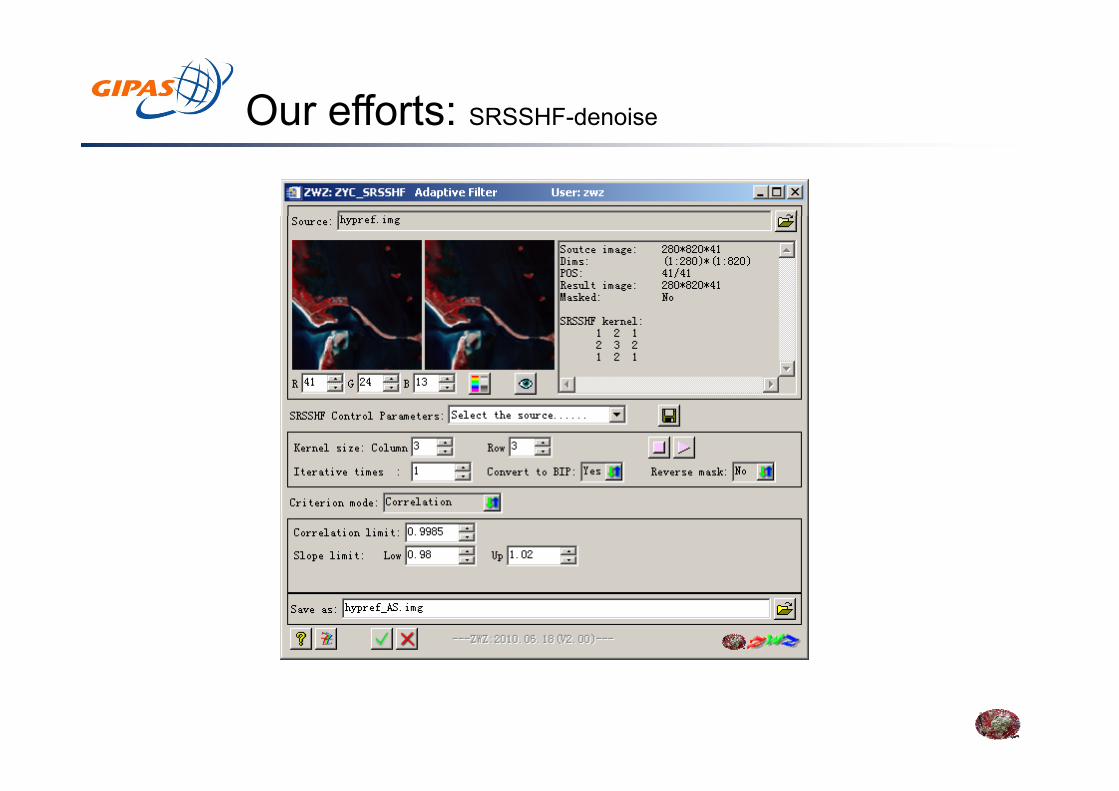
Our efforts: Wate correction (WRC)( )
Image=(seagrass+seabed) +(water suface+wave)+benthal topographty+水
Study background:
water body(+sun)+atm.+noise
Achievements:Lee (1994,1999), Mumby, P. J.(2002), Dekker, A. J.(2005), Mishra, D. R.(2005), ……
Basic works and data:Depath, water absorption/scatter properties and spectral extensionp p p p p
Austin, P. (1986), Baker, S.(1982), ……
Status: no tools
Model incomplete, approximate expression, water surface, water-solid interface, solar-sky light effect.
Key technologies/problem:
Model incomplete, approximate expression, water surface, water solid interface, solar sky light effect.
Αβestimation and spectral extension
Consider too more on the components (HydroLight)
N f l lNo useful tools
Validation problems: the methods of Mumby, Lee—only for multispectral

Our efforts: Wate correction (WRC)
modelsSun illuminationDirectional
IFOV
( )
Surgeless or idealWater surfaceLiquid-gas surface
Real water surfacewith wave and foamLiquid-gas surface
WaterLiquid body
Atm. IlluminationHemisphere
AtmosphereGas body
Natural sea bottomTerrain effectliquid-solid surface
Submerged vegetationForest like with water mediumLiquid-vegetation surfaceLiquid + vegetation body
Canopy of submerged vegetationwater mediumSooth the submerged terrain
Our models
Our efforts: Wate correction (WRC)
Sun illuminationDirectional
IFOV
( )
Surgeless or idealReal water surfacewith wave and foam
Atm. IlluminationHemisphere
AtmosphereGas body
Water surfaceLiquid-gas surface
with wave and foamLiquid-gas surface
Natural sea bottomTerrain effectliquid-solid surface
Canopy of submerged vegetationwater mediumSooth the submerged terrain
WaterLiquid body
Submerged vegetationForest like with water mediumLiquid-vegetation surfaceLiquid + vegetation body

Our efforts: Wate correction (WRC)
Our model and softwaretool
( )
Our model and softwaretoolFeatures
Emphasize to remove the effect of water surface( wave—skylight)Angle effect of mirror reflect—hot pointFor Absorption feature, the whole body is considered but not
Sun illuminationDirectional
Atm. IlluminationHemisphere
IFOVthe component in detailCombined with ACResidual effect (difference) of solar and sky light after GC
Surgeless or idealWater surfaceLiquid-gas surface
Real water surfacewith wave and foamLiquid-gas surface
WaterLiquid body
AtmosphereGas body
( ) y gDepth estimation with background effectAvailable for iterative to optimize the input parametersSpectral extension with nonlinear method
Natural sea bottomTerrain effectliquid-solid surface
Submerged vegetationForest like with water mediumLiquid-vegetation surfaceLiquid + vegetation body
Canopy of submerged vegetationwater mediumSooth the submerged terrain
Liquid bodySpectral extension with nonlinear methodConsider imaging geometry

Our efforts: Wate correction (WRC)
WRC software
( )

Our efforts: Wate correction (WRC)
Water surface and sky light correction
( )

Our efforts: Wate correction (WRC)
Parameter estimation Field validation
( )
0.5-3m,depth absorption coefficient scatter coefficient

Our efforts: Wate correction (WRC)
Parameter estimation
( )
α coefficient -spectrum β coefficient-spectrum

Our efforts: Wate correction (WRC)
Back scatter correction (path radiance of water)
( )
Back scatter estimation
After correction

Our efforts: Wate correction (WRC)
Water depth correction
( )
before after

Our efforts: Wate correction (WRC)
Water depth correction
( )
校正前后光谱对比

Our efforts: Wate correction (WRC)
Water correction
( )
before after

Our efforts: Wate correction (WRC)
Water correction
( )

Our efforts: Wate correction (WRC)( )

Our efforts: Wate correction (WRC)
Validation:
( )

Our efforts: Wave removing

Our efforts: Wave removing

Our efforts: seagrass information extraction
Classifications

Our efforts: seagrass information extraction
mixing of seagrass andand epiphyte
Slope intercept C.C Composed ΔR
B329,218,107

Our efforts: seagrass information extraction
RR
ΔR
CSAM
Slope

Problems of spectral measurement

Current or future works: Precise water spectrum measurementmeasurement
Problems of spectral measurementp
Traditional:
Ours:
Refo=Rado (Refr/Radr) Refo=Rado (Kp*Refr/Radr)

Current or future works: Precise water spectrum measurementmeasurement
Problems of spectral measurementProblems of spectral measurement

Current or future works: Precise water spectrum measurementmeasurement
On boat

Current or future works: Precise water spectrum measurementmeasurement

Current or future works: Precise water spectrum measurementmeasurement

Current or future works: Precise water spectrum measurementmeasurement

Suggestion
For seagrass information extraction from remote sensing images,g g gprecise preprocessing including optimization is necessary. Ouralgorithm or tools may be helpful for application.Maybe we can pay some attention on the method/tool/criterion review,at least in remote sensing seagrass information extraction, for thefuture working procedure discussion but not only focus on the datafuture working procedure discussion, but not only focus on the datacollection. data useful? ---tools or technology useful?For seagrass information extraction via remote sensing images, somekey/basic parameters are very important, such as depth (with certainresolution), seabed types, α,β…… So why not we focus on such data
ll icollection?The change!

Thank you!