Embed Size (px)
Citation preview
Introduction to GIS
PHILIPPINE WEALTH ACCOUNTING
AND VALUATION OF ECOSYSTEM
SERVICES (PHIL-WAVES)
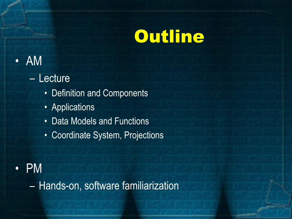
Outline
• AM
– Lecture
• Definition and Components
• Applications
• Data Models and Functions
• Coordinate System, Projections
• PM
– Hands-on, software familiarization
• Sources of images: Lee, Angela, ESRI Source: GIS Online @ UWF 2013baw32.blogspot.com
Source: Lee, Angela ESRI
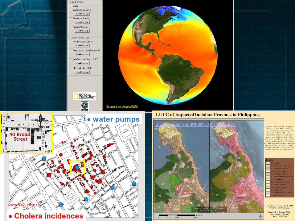
Source: OBSN, Intro to GIS

GIS is not just
map-making
Mapping = Cartography
GIS = GIS
“Geographic + Information
+ System”
“Spatial location +
Attributes/database +
Hardware-software-user

GIS Components
• Geographic – Spatial, space-bound, location-based

GIS Components
• Information System– collection of attributes,
descriptive, tabular, software-based

GIS is an integrated
collection of:
• Hardware, software, data, processes, people
Used to:
• View/manage information
• Analyze spatial relationships
• Model spatial scenario
• Present analysis or results

Various GIS Definitions
• A map with a database behind it.
• A virtual representation of the real world and its infrastructure.
• A consistent “as-built” of the real world, natural and manmade
Which is
• queried to support on-going operations
• summarized to support strategic decision making and policy formulation
• analyzed to support scientific inquiry

Decision
GIS Process Output
GIS
analysis
Import or
build datasets
Define GIS
criteria
Define
problem Decision
GIS Process Output
GIS
analysis
Import or
build datasets
Define GIS
criteria
Define
problem
GIS System

Knowledge Base for GIS
Application Area:
public admin.
planning
geology
mineral exploration
forestry
site selection
marketing
civil engineering
criminal justice
surveying
Computer
Science/MIS
graphics
visualization
database
system administration
security
Geography
and related:
cartography
geodesy
photogrammetry
landforms
spatial statistics. The convergence of technological fields and traditional
disciplines.
GIS

Why Learn it?
• Multi-disciplinary
• A real-world technology using real data
• Involves authentic tasks / assessments
• Promotes holistic / systematic approach
• Engages multiple ways of learning
• Encourages community connections
• Used at scales from local to global

Why Learn it?
• There are important geographic questions about
changes in & their socioeconomic/political
implications Roger Tomlinson
Changing the Face of Geography (2009)
• “Climate change is a geographic problem,
Solving it takes a geographic solution. ” Jack Dangermond
Founder & President, ESRI

Geography matters!
Today’s challenges require geographic approach
• Climate Change
• Urban Growth
• Sustainable Agriculture
• Water Quality and Availability
• International and National Security
• Energy
• Epidemiology/Disease Tracking
• Natural Hazards

Agriculture
– Farm management
– Pest/Disease tracking
– Crop monitoring
– Yield prediction
– Soil analysis

Disaster Risk Reduction
and Management
• Vulnerability Assessment
• Hazard Modeling
• Easements and Relocation Schemes

Natural Resource
Management
• Forestry
• Ecology
• Mining
• Fisheries
• Biodiversity
Conservation

Planning and
Economic Development
• Land Use/Zoning
• Population Forecast
• Market Analysis
• Tax Mapping
• Transportation

Ecosystems Services
Accounting
• Ecosystem Accounts
• Opening-Closing stocks
• Economic Valuation
• Scenario Modeling

Specific Uses and Users
Source: OBSN, Intro to GIS

Other Sample
Applications
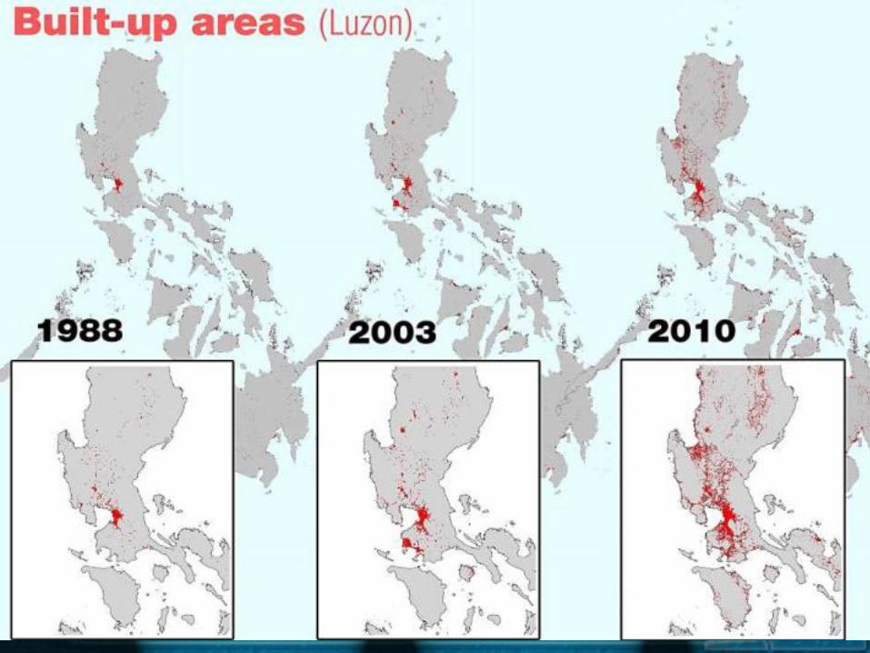
• Land-use Changes

Flood mitigation
DPWH report: Flood management master plan for Metro Manila and
...www.gov.ph

GIS Models
• Raster
• Vector
Representing Spatial
Elements

Raster
Stores images as rows and columns of numbers with a Digital Value/Number (DN) for each cell.
Units as square grid cells that are uniform in size.
Numerous data formats
(common: TIFF, GIF,
ERDAS.img etc)

Source: OBSN, Intro to GIS

Source: OBSN, Intro to GIS

• Rasters are resolution-based
Source: OBSN, Intro to GIS


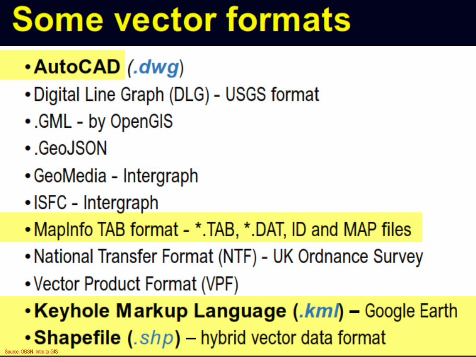
Vector
Allows user to specify specific spatial locations and assumes that geographic space is continuous, not broken up into discrete grid squares
We store features as sets of X,Y coordinate pairs.
Source: OBSN, Intro to GIS

Source: OBSN, Intro to GIS

Source: OBSN, Intro to GIS
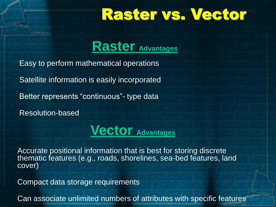
Raster vs. Vector
Raster Advantages
Easy to perform mathematical operations
Satellite information is easily incorporated
Better represents “continuous”- type data
Resolution-based
Vector Advantages
Accurate positional information that is best for storing discrete thematic features (e.g., roads, shorelines, sea-bed features, land cover)
Compact data storage requirements
Can associate unlimited numbers of attributes with specific features

Source: OBSN, Intro to GIS

Representing Spatial
Elements
• RASTER
• VECTOR
• Real World

Spatial data (ARC functions)
Attribute data
(INFO or TABLES functions)
1 (Universe polygon)
2 3
4 5
GIS Storage
3
COV# ZONE ZIP
1 0
2 C-19 22060
3 A-4 22061
4 C-22 22060
5 A-5 22057
3 A-4 22061
GIS Functions

• Common Manipulation
– Rectifying
– Reclassification
– Map Projection changes
• Common Analysis
– Buffering
– Overlay
– Interpolation
Spatial Data Manipulation and Analysis

Spatial Analysis
• Overlay function creates new “layers” to solve spatial problems

• Tables
• 2-D Maps
• Interactive Displays
• 3-D Maps
Spatial Data Output
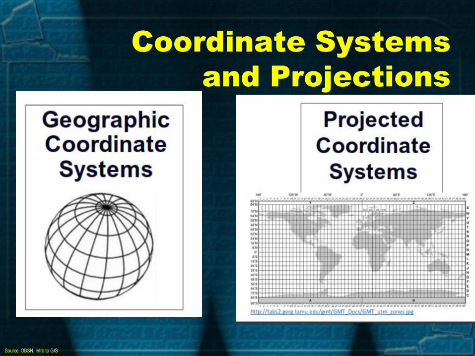
Coordinate Systems
and Projections
Source: OBSN, Intro to GIS

Geographic Coordinate
System (GCS)
Source: OBSN, Intro to GIS

Source: OBSN, Intro to GIS

Source: OBSN, Intro to GIS

Projected Coordinate
System (PRS)
Source: OBSN, Intro to GIS
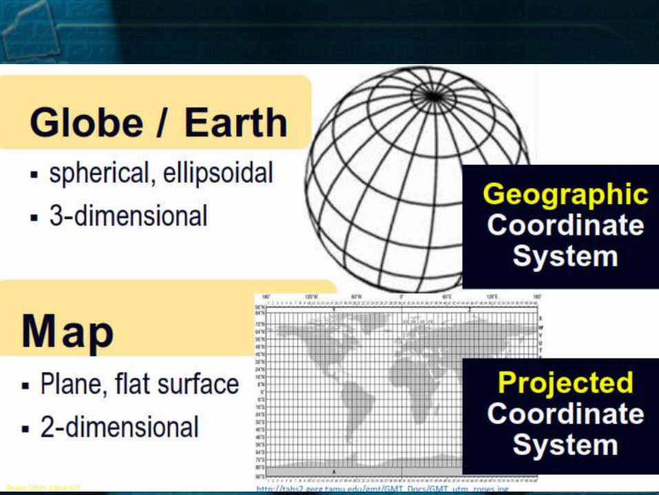
Source: OBSN, Intro to GIS

Universal Transverse
Mercator
• meters as unit (precise measurements)
• Universally accepted by many countries by
scientific community
• Based on WGS 1984
• Adopted in most RS, topo-map preps. & natural
resource DBase dev’t (De Mers, 2005)
• Philippines = UTM Zone 51 N (except for Palawan)

Source: OBSN, Intro to GIS

What’s the CS of
LLDA Office?
Geographic (WGS 1984 datum)
• Decimal Degrees - 14.644581°, 121.046187°
• Decimal Minutes - 14° 38.675'N, 121° 2.771'E
• Decimal Minutes Seconds - 14°38'40.43"N, 121° 2'46.29"E
Projected (UTM Zone 51N)
• UTM - 289572.26 m E, 1619921.13 m N

Important People
• Father of GIS – Dr. Roger Tomlinson
• Published “Mode of Communication of Cholera” (Soho
Cholera Outbreak, 1854) - Dr. John Snow
• You

Short Quiz
1. T or F : GIS is synonymous to mapping
2. What GIS model to use : Political Boundaries
3. Give 2 common GCS in the Philippines
4. Give the UTM projection in the Philippines
5. True or False : UTM unit is degrees
6. Is cellphone a GIS medium?
7. T or F : 90m DEM is better then 30m DEM
8. T or F: Is GIS new?