Embed Size (px)
Citation preview

1
CHAPTER 1
INTRODUCTION TO THE AREA
1.1. Name, location, constitution and extent
Chinnar Wildlife Sanctuary was declared as a wildlife sanctuary in August 1984 as per
notification (G.O (P) No. 229/84/AD) of the Kerala Government. It is located in the eastern part
of the High Ranges of southern Western Ghats of Kerala. The Sanctuary, which is situated
between 10° 15’ to 10° 21’ N latitude 77° 05’ to 77° 16’ E longitude, has a total area of 90.44
km². The area was notified as a reserve forest in May 1942 vide notification R.Dis.No.
1414/42/Devpt (Annexure -1) The area falls in the Marayoor and Kanthalloor Panchayat of
Devikulam Taluk in Idukki District and is regarded as one of the important protected areas in
the Western Ghats due to its ecological, floral and geomorphological significance. It falls under
the jurisdiction of Munnar Wildlife Division which has its Headquarters at Munnar. The habitat
types range from shola-grassland to dry thorny scrub, across a diverse cultural landscape as
well, making the PA unique in comparison with others.
1.2. Approach and access
The Sanctuary is accessible from Kochi (180 km) and Coimbatore (110 km) airports along main
roads. The Munnar–Udumalpet road that passes through the Sanctuary for 16 km. roughly
divides it into more or less equal portions. The nearest railway station in Kerala is Aluva
(180km.) and in Tamil Nadu, Pollachi (60km.). The nearest town is Marayoor.
1.3 Statement of Significance
Chinnar Wildlife Sanctuary is located in the rain shadow region of Western Ghats and
represents a large number of plants and animals unique to the thorny vegetation. Apart from
the dry thorn forests, due to the significant variation in altitude and rainfall, it has a wide array
of habitat types like deciduous forests, dry thorny forest, riparian forest, sholas and grasslands
that are interspersed with plains, hillocks, rocks and cliffs which provide microhabitats for
varied forms of life. The Sanctuary falls under the Anamudi Elephant Reserve. It is an abode of
reptilian fauna and the richest in Kerala in terms of the number of species. Albizia lathamii, a

2
Locatio
n o
f K
urin
jim
ala
Wil
dli
fe S
an
ctu
ary
Map
. 1 :
Loca
tio
n M
ap o
f C
hin
nar
Wild
life
San
ctu
ary

3
M
ap
. 2

4
M
ap
. 3

5
critically endangered species has been reported from the dry forests of Chinnar. It is a well
known repository of medicinal plants. The riverine forests along Chinnar and Pambar support a
healthy population of Grizzled Giant Squirrel. The famous ‘white bison of Manjampatti’ has
been reported from Chinnar. With 225 species of birds, Chinnar is rich in avian diversity. In
association with the neighbouring PAs, Chinnar forms part of a viable conservation unit. The
Sanctuary provides livelihood options and helps in maintaining the cultural heritage of tribes
such as Hill Pulayas and Muthuvans. Archaeologically significant megalithic burial sites
consisting of dolmens and cysts are found within the Sanctuary. Chinnar Wildlife Sanctuary
offers great opportunities for developing a dynamic model of biodiversity conservation in a
human dominated landscape. It is the only habitat in the state where the endangered Grizzled
Giant Squirrel (Ratufa macroura) and Indian Star Tortoise (Geochelone elegans) are seen.
1.4 Values of the Protected Area
1.4.1 Value related to flora
Repository of Medicinal Plants of ethno botanical importance
Its habitat spectrum - especially a wide range of altitudinal zonation and
consequent unique biodiversity
Only sanctuary in Kerala with a riparian gallery forests
• Only sanctuary in Kerala with dry deciduous forests and sandal forests
Presence of Albizzia lathamii, a critically endangered tree species
1.4.2 Value related to fauna
• Supports the only population of Grizzled Giant Squirrel in Kerala
• Richness in avian and reptilian diversity
• Presence of Star Tortoise, Marsh Crocodile, Yellow Throated Bulbul, Tufted Grey
Langur

6
1.4.3 Values related to watershed
Prominent catchments of an East flowing river particularly, the immediate
catchment of Amaravathi reservoir in Tamil Nadu
1.4.4 Geographical Values
Being the only link between Anamalai hills and the Kodaikkanal slopes the
Sanctuary occupies a pivotal position in the eastern slope forests of the Western
Ghats
Crucial for the longevity of the shola grassland ecosystem of Eravikulam National
Park and southern portion of the Anamalai Tiger Reserve of Tamil Nadu
1.4.5 Archaeological and Anthropological Values
• Only protected area in Kerala with Hill Pulaya tribal community.
• Remnants of Megalithic Burial sites including Dolmens and cysts
1.4.6 Aesthetic and Educational Values
• Opportunities of human ecological studies
• Eco – Tourism Potential
• Potential for imparting Nature Education.

7
FLAGSHIP SPECIES
Fig . 1 Grizzled Giant Squirrel (Ratufa macroura)
The Grizzled Giant Squirrel (Ratufa macroura) is a large tree squirrel in the genus Ratufa found
in the highlands of the Central and Uva provinces of Srilanka, and in patches of riparian forest
along the Kaveri river and in the hill forests in Kerala and Tamil Nadu. IUCN lists the species as
Near Threatened due to habitat loss & poaching. R. macroura is the smallest of the giant
squirrels found in the Indian subcontinent, with a head and body length of 25 to 45 centimeters
(9.8 to 18 in), and tail measuring roughly the same or more), for a total length of 50 to 90
centimeters (20 to 35 in). It has small rounded ears with pointed tufts. The home range of an
individual is between 1,970 and 6,110 square meters.
In India, the species can be seen only in Chinnar Wildlife Sanctuary & Grizzled Giant
Squirrel Sanctuary in Tamil Nadu.

8
Fig. 2 Indian Star Tortoise (Geochelone elegans)
The Indian Star Tortoise (Geochelone elegans) is a species of tortoise found in dry areas and
scrub forest in India and Srilanka. A large number of specimens of this species are found in the
illegal wildlife trade in India. Chinnar Wildlife Sanctuary is home to this endangered species.

9
CHAPTER 2
BACKGROUND INFORMATION AND ATTRIBUTES
2.1. Boundaries
2.1.1. Legal Boundaries
The erstwhile Chinnar Reserve was notified as a Sanctuary in 1984. The original notification of
the Chinnar Reserved Forest dates back to 1942 and the boundaries follow a jumble of cairn
numbers and survey numbers. At present the boundaries are fully demarcated but in certain
areas like Njavala-Ollavayal, the status is vague and may not correspond to the situation on the
field.
The boundary description as per the notification is as follows:
North:- Starting from cairn No.1 at the trijunction of the boundaries of Coimbatore District,
Marayoor Pakuthy and Kannan Devan Hills at the North West corner of the Reserve, the line
goes in a nearly north easterly direction for about 5643/4 chains along the Chinnar River to
cairn No.2 at a State Boundary Survey Stone on the bank of the Chinnar River, thence more or
less east- south east for about 2141/4 chains along the above said river to cairn No.3 at the
State Boundary Survey Stone on the bank of the river side of that Survey No. for about 11/4
chains to cairn No.4 at its south west corner. (This is also the Western most point of
S.No.251/1/1). Thence nearly east along the south side of the S.No. 257/1/1 for about 333/4
chains passing cairns No. 5 to 15 to cairn No.16 at its south east corner. Thence nearly south for
about 63/4 chains to cairn 17 thence nearly south for about 63/4 chains passing cairn No.18
and crossing the approach road to the P.W.D. camp shed to cairn No.19 at the right bank of the
thodu flowing to Chinnar River – then nearly north along that thodu for about 103/4 chains to
cairn No.20 at its junction with the Chinnar River (from cairn numbers 16 to 20 the boundary
follows the Western, Southern and Eastern Boundaries of the area allowed for the P.W.D.
excluding the same from the reserve.) thence nearly east along the Chinnar River for about
71/2 chains to cairn No.21, on its bank; thence nearly south east for about 43/4 chains passing

10
cairn number No.22, 23 to cairn No.24 on the West side of the approach road to the P.W.D.
camp shed; thence east by slightly south for about 3/4 chains crossing the above road to cairn
No.24A; thence nearly east- south east for 1 chain to cairn No.24B; thence nearly north-north
east for 31/2 chains to cairn No.24C, thence east for 3/4 chains to cairn No.24D, thence north
for 11/2 chains to cairn No.24E, thence west for 3/4 chains to cairn No.25; thence nearly north
west for about 11/4 chains crossing the northern outlet road to cairn No.26 on the right bank of
the Chinnar river situated 81 links north west of the State Boundary Survey Stone between
distance 438 and 500, (from cairn 21 to 26 the boundary follows the Western, Southern and
Eastern boundaries of the area allowed for the Excise Office Cart Stand and tollgate excluding
the same from the reserve); thence nearly east along the same river for about 11 chains to
cairn No.27 at the Revenue Stone at the North West Corner of Survey 261/1; thence nearly
South West along its West side for about 11/4 chains to cairn No.28 at its South West Corner,
thence along the West, South and East sides of Survey No. 259/1 for about 63/4 chains passing
cairn Nos. 29 to 31 to cairn No.32 at its North East corner; thence nearly East along the Chinnar
River for about 721/2 chains to cairn No.34; it is junction of Pambar River with Chinnar River.
East:- Thence nearly South- South West along the left bank of the Pambar River for about 43/4
chains to cairn No. 36 situated on the left bank of Athioda stream at its confluence with the
Pambar thence nearly South South-East along the Athioda Stream (the boundary between
Travancore and Coimbatore District) for about 4511/4 chains to cairn 37 where Athiodai cross
the State Boundary for about 1263/4 chains to cairn No.38 at the top of Jambu malai peak at
the trijunction of Coimbatore and Madurai Districts and Travancore State (This peak is locally
known as ‘Chinna Chambu Malai’).
South and West:- Thence nearly south west along the state boundary for about 38 chains to
cairn No. 39 at the boundary stone at the north-east corner of survey No. 72/1 of Kothukombu
Pakuthy at the trijunction of Keelanthur and Kottakombu Pakuthies of Devikulam Taluk and
Palani Taluk of Madurai District (This place is locally known as Vellimalai); thence in the same
direction for about 631/2 chains along the boundary between Keelanthur and Kottakombu
Pakuthies to cairn No. 40 at “Chenkannimala” thence nearly West South-West along the above
Pakuthy boundary for about 531/4 chains passing Velliyangiri hills to cairn No. 41 at the Village

11
Boundary Stone at the trijunction of Kilanthur, Kootakombu and Kanthaloor Pakuthies (this
place is also known as Vattachola lower); thence nearly North West for about 231/2 chains to
cairn No. 42 at a Village Boundary Stone between Kanthaloor and Kilanthur Pakuthies, (this
place is also known as Vattachola Upper) thence in same direction but more to the West for 30
chains to cairn No. 43 on the right bank of the Vannanthorai Stream ; thence nearly West North
West along the right bank of the above stream for about 1091/2 chains to cairn No. 44 (here
the stream leaves the boundary)) thence nearly North for about 21/2 chains to cairn No. 45 it
has theodolite stone at the South East Corner of Survey No. 300/1 of Kilanthur Pakuthies
thence along the East side of the above survey Number for about 9 chains passing cairn No.s 46
and 47 to cairn No. 85 of Vannathorai Sandal Wood Reserve Block No. 11 at the theodolite
stone at the North East Corner of Survey No. 300/1 thence along the Eastern, Northern and
Western Boundaries of that reserve to its South West Corner at cairn No. 104 at a theodolite
station on the right bank of the Kalikilavan Odai, thence nearly South West along the same bank
of the said Oda for about 8 chains to its junction with the Vannanthorai River, thence along the
right bank of the Vannanthorai River first nearly West North – West and then North-North West
for about 1401/2 chains to cairn No. 48 at its junction with the Pambar River thence nearly
North along the right bank of Pambar River for about 1071/2 chains to cairn No. 49 thence
nearly North West for 21/2 chains crossing the Pambar River to cairn No. 50 on the left bank of
Natchimuthu Odai at its confluence with the Pambar River: thence nearly South West along the
left bank of the Natchimuthu Odai for about 831/4 chains to cairn No. 51 about 3/4 chains
South of the theodolite stone at the South East Corner of Survey No. 256/1; thence nearly
North West along the East side of the above Survey Number for 3 chains to cairn No. 52 at
theodolite stone at its North East Corner; thence more or less West for its Eastern edge; thence
more or less West for about about 7 chains to cairn No. 53 at the first quarter of the 29th mile
of the near road on its Eastern edge; thence crossing the road for 1 chain to cairn No. 54 on its
Western edge; thence along the same edge of the road first nearly West South West and then
nearly North West for about 392 chains to cairn No. 65 where the Natchimuthu Odai crosses
the above road; thence along the left bank of the same Odai for about 61/2 chains to cairn No.
56 on the Southern side of Survey No. 227/2; thence along and Southern side of Survey No.

12
227/2 and Southern, Eastern and Northern sides of Survey No. 227/1 for about 181/4 chains
passing cairn No. 57 to 64 to cairn No. 65 at the North West Corner of Survey No. 227/1 on the
left bank of the Natchimuthu Odai for about 483/4 chains to cairn No. 66 at the theodolite
stone at the South West Corner of Survey No. 2881/2; thence skirting the Southern Eastern and
Northern sides of the above Survey No. for about 261/4 chains passing cairn No. 67 to 75 to
cairn No. 76 at the theodolite stone at the North West Corner of the Survey Number on the left
bank of the Natchimuthu Odai; thence first nearly North West and then West North -West
along the same bank of the above Odai for about 156 chains to cairn No. 77 on the same bank
Nandulamalai thence nearly South West for about 160 chains through Sy. No. 286/1/1 of
Marayoor Pakuthy passing cairn Nos. 78 to 80 to cairn No. 81 at a boundary stone on the
boundary between the Kannan Devan Hills and Marayoor Pakuthies to the North of Kumarikal
malai and to the East of Poovar thadam thence nearly North West along the above boundary
for about 146 chains passing cairns 82 to 91 (this line crosses the Poovar between cairn Nos. 85
and 86) to cairn No. 1 at the starting point on the Northern Boundary.
2.1.2. Ecological Boundaries
On the North and East, it shares a 30 km common boundary with the Anamalai Tiger Reserve of
Tamil Nadu. On the West, it is bordered by the Eravikulam National Park. On the southern side,
it is bordered by the Reserve Forests of Marayoor Sandal Division, part of Kurinjimala
Sanctuary, and also by Revenue Lands. The Park provides ecological connectivity between the
Anamalai Tiger Reserve and Eravikulam National Park.
2.1.3. Internal Boundaries
The description of internal boundaries demarcating the private rights admitted within the
reserve is specified in the reserve notification of 1942. The boundaries of the rights admitted
for the PWD quarters at Chinnar and the enclosure at Ollavayal is vague and needs to be
verified on field.
Earlier the Sanctuary area was divided into two Sections namely Chinnar and Karimutty and
internal boundary for the sections were specified. Forest Station system was introduced in
13
August 2005 and the entire sanctuary was brought under one forest station Karimutty. Hence
these section boundaries became irrelevant.
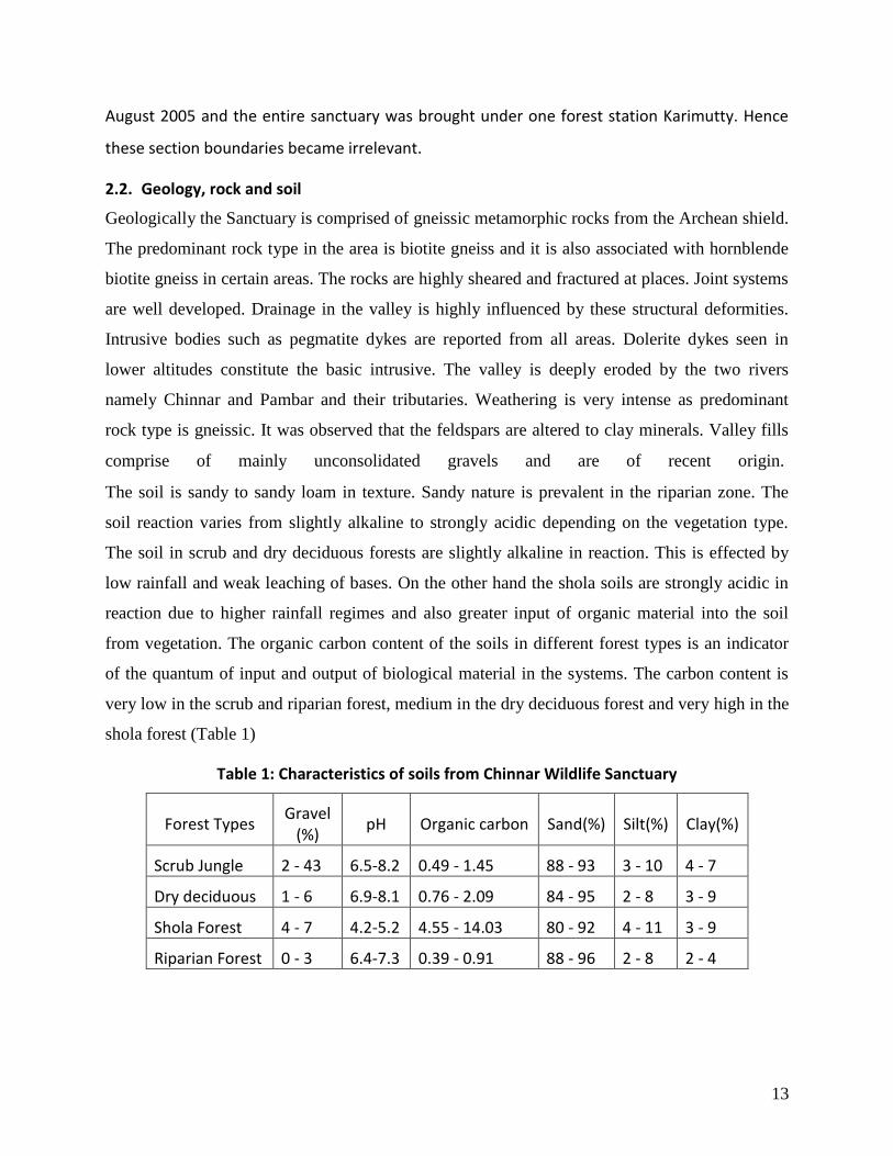
2.2. Geology, rock and soil
Geologically the Sanctuary is comprised of gneissic metamorphic rocks from the Archean shield.
The predominant rock type in the area is biotite gneiss and it is also associated with hornblende
biotite gneiss in certain areas. The rocks are highly sheared and fractured at places. Joint systems
are well developed. Drainage in the valley is highly influenced by these structural deformities.
Intrusive bodies such as pegmatite dykes are reported from all areas. Dolerite dykes seen in
lower altitudes constitute the basic intrusive. The valley is deeply eroded by the two rivers
namely Chinnar and Pambar and their tributaries. Weathering is very intense as predominant
rock type is gneissic. It was observed that the feldspars are altered to clay minerals. Valley fills
comprise of mainly unconsolidated gravels and are of recent origin.
The soil is sandy to sandy loam in texture. Sandy nature is prevalent in the riparian zone. The
soil reaction varies from slightly alkaline to strongly acidic depending on the vegetation type.
The soil in scrub and dry deciduous forests are slightly alkaline in reaction. This is effected by
low rainfall and weak leaching of bases. On the other hand the shola soils are strongly acidic in
reaction due to higher rainfall regimes and also greater input of organic material into the soil
from vegetation. The organic carbon content of the soils in different forest types is an indicator
of the quantum of input and output of biological material in the systems. The carbon content is
very low in the scrub and riparian forest, medium in the dry deciduous forest and very high in the
shola forest (Table 1)
Table 1: Characteristics of soils from Chinnar Wildlife Sanctuary
Forest Types Gravel
(%) pH Organic carbon Sand(%) Silt(%) Clay(%)
Scrub Jungle 2 - 43 6.5-8.2 0.49 - 1.45 88 - 93 3 - 10 4 - 7
Dry deciduous 1 - 6 6.9-8.1 0.76 - 2.09 84 - 95 2 - 8 3 - 9
Shola Forest 4 - 7 4.2-5.2 4.55 - 14.03 80 - 92 4 - 11 3 - 9
Riparian Forest 0 - 3 6.4-7.3 0.39 - 0.91 88 - 96 2 - 8 2 - 4

14
The gravel content in the soils in scrub forest is higher than in other vegetation types indicating
high degree of erosion. In the shola soil the content of gravel is negligible and this is due to the
closed canopy present there.
2.3. Terrain
The terrain is undulating with hills and hillocks of varying heights. The altitude ranges from
400 m at Chinnar to 2372 m at Nandalamala. The other major peaks in the Sanctuary are
Varayattumalai (1845m), Thengamalai (1422m), Vellakkalmalai (1883m), Jambumalai (1395m),
Aralipara (1494m), Karumalai, Anakkunnu and Jellimalai. The area is drained by two perennial
rivers passing through the Sanctuary, namely Chinnar and Pambar. During north east monsoon
which is the dominant rainy season, a few ephemeral water sources take origin from higher
mountains and drain the area and they dry up for the rest of the season. The digital elevation
model of Chinnar Wildlife Sanctuary is given as Map : 4.
2.3.1. Contour
See Map 5: Contour map of Chinnar Wildlife Sanctuary (based on 1:50,000 SOI top sheets)
2.4. Climate
The Sanctuary is situated in the rain shadow region and hence the area experiences prolonged
hot/dry season and much less rainy days. The Chinnar plains are generally hot, but the higher
altitudes are cool. Chinnar Wildlife Sanctuary shows wide variations from the rule of altitudinal
gradient determining microclimate. Apart from elevation, rainfall is an important parameter in
regulating the temperature in the Sanctuary. The solar radiation in Chinnar is high, mainly
because of less cloud cover.
The only meteorological data available with the department is the rainfall data recorded at
Chinnar and is typical to the dry thorn forests of the Sanctuary. Due to factors like altitude and
aspect, there is large variation in the climatic conditions across the Sanctuary.

15
2.4.1. Rainfall pattern and distribution
The rainfall regime of the Sanctuary is characterized by the highly variable precipitation linked
with the cyclonic disturbances affecting the Bay of Bengal during the withdrawal of monsoon.
The major rainfall season is during the north-east monsoons occurring during October-
December.

16
M
ap
. 4

17
M
ap
. 5

18
December. The rainy days in a year range between 30 to 40 days which account for about 300 -
500 mm rainfall in Chinnar and adjacent areas. But the higher altitudes areas like Olikkudy and
Mangappara receive rain during both north-east and south-west monsoons with comparatively
much higher rainfall. On an average the region has 6-7 months of dry period in the lower
reaches and a lesser amount of dry months in the higher reaches.
Presently rainfall data is recorded only in Chinnar, which gives an idea of rainfall pattern in the
Dry reaches of the protected area. Data recorded for the past 12 years is incorporated below
for reference.
The rainfall data from 2000 to 2011 is given in Table 2 below.
Table 2: Monthly Rainfall Data from 2000 to 2011
Year Monthly Rain fall data in mm
Jan Feb Mar Apr May Jun Jul Aug Sep Oct Nov Dec Total
2000 24.0 44.0 4.0 98.0 41.4 33.3 48.0 88.0 212.5 8.3 104.0 125.5 831.0
2001 21.0 10.0 17.0 66.0 80.0 39.0 53.1 5.0 144.0 113.0 114.0 122.0 784.1
2002 4.0 30.0 62.2 14.0 104.0 37.0 4.0 38.0 11.0 204.9 34.1 69.0 612.9
2003 0.0 0.0 19.0 134.4 76.9 112.2 6.1 0.00 17.7 242.2 235.0 19.0 862.5
2004 0.0 0.0 0.0 24.3 103.8 84.6 46.6 17.9 179.0 255.9 342.2 10.6 1064.9
2005 0.0 0.0 1.2 93.4 76.2 15.7 81.8 54.3 43.0 132.3 470.4 243.5 1211.8
2006 53.2 0.0 15.0 20.0 105.7 105.2 0.0 15.5 45.6 122.2 253.3 0.0 735.7
2007 9.0 0.0 13.0 0.0 105.6 66.0 59.0 92.0 103.9 149.9 43.0 139.0 780.7
2008 51.0 0.0 111.2 7.0 44.0 19.3 58.0 47.0 85.3 201.6 109.3 69.4 803.1
2009 11.3 0.0 22.0 1.0 35.5 14.3 44.8 68.6 21.8 77.4 278.6 157.2 732.5
2010 5.0 0.0 0.0 29.2 17.2 27.6 94.3 13.0 129.0 133.0 396.0 66.4 910.7
2011 0.0 0.0 0.0 41.0 41.0 30.2 8.0 28.2 34.5 173.0 223.0 12.0 590.9
2.4.2. Temperature, a summary of year round pattern
The temperature of the area is influenced by the Coimbatore-Mysore thermic regime. The
mean temperature is relatively constant from July to October. The region has 6-7 month of dry
period in the lower areas and lesser dry months in the higher altitudes. Presently no data is
available as far as temperature is connected. No authenticated records are available.

19
2.4.3. Humidity
During north- east monsoon (Oct-Dec) the average humidity of the area is maximum and varies
from 80% – 90 %. From June to September, the period of the south-west monsoons on the
western aspects of the Ghats, the humidity varies from 60%-80 %. During the rest of the year,
the average humidity varies from 57%-70%.
2.4.4. Wind speeds
The wind velocity recorded at Chinnar shows a more or less uniform magnitude except for the
slightly higher speeds recorded during some monsoon months. The maximum wind speed is
obtained during south-west monsoons (5.8m/s) and the average is around 1m/s. No
authenticated records are available.
2.5. Water sources
Chinnar and Pambar are the major sources of water. Both originate in the sholas of the upper
reaches. Pambar traverses the Turner’s Valley in Eravikulam National Park and flows down into
Chinnar Wildlife Sanctuary through the Talliar Valley. Chinnar follows the interstate boundary.
These two rivers merge at Koottar and drain into the Amaravathy reservoir in Tamil Nadu. Most
of the rivulets and streams inside the Sanctuary come alive immediately after the north-east
monsoons and dry up soon. The water in the check dams remains for a longer period but they
also dry up during summer months. But a few streams originating from the upper reaches are
perennial. Check dams also remain dry for most of the year and at present, are silted up. When
the north-east monsoons fail, as in recent years, water becomes a limiting factor in many
areas.
The name and location of check dams in the Chinnar Wildlife Sanctuary are as follows:
1. Watch Tower 2. Pazhayakudithara
3. Charalmedu 4. Kallukadu
5. Chinnar 6. Churulipetty
7. Amenity Centre, Chinnar 8. Chambakkadu
9. Orumala 10. Muthalakulam
11. Old PWD Rest House 12. Mannala

20
13. Mangayoda 14. Alampetty
15. Pelakulam 16. Veerapparamoda
17. Kathirithodu 18. Eruttalakudy
Drainage
The drainage map of the Chinnar Wildlife Sanctuary (Map :6) was generated digitally using SOI
top sheets and watershed atlas maps of Kerala State Land Use Board. No proper water resource
map is generated.
2.6. Range of wildlife, status, distribution and habitat
The Sanctuary offers a wide range of habitat types to the flora and fauna. There are 965 species
of flowering plants, 28 species of mammals, 225 species of birds, 14 species of fish, 15 species
of amphibians, 156 species of butterflies and 52 species of reptiles recorded from the
Sanctuary. Rainfall and terrain are the important factors that influence animal movements. The
11 settlements spread across the sanctuary also have significant impact on the range of wildlife
and habitat.
2.6.1. Vegetation
Vegetation
The vegetation shows an entire spectrum ranging from sub-temperate sholas to dry scrub of
the arid plains. In many areas, the vegetation of the Sanctuary is highly disturbed mainly due to
a combination of factors like earlier fellings and planting and anthropogenic pressures of the
settlements inside and on the fringes, particularly cattle grazing. Therefore in many cases
secondary forest types replace primary types and an obvious classification of forest types is
impracticable. Notwithstanding these, the vegetation of the Sanctuary can be broadly classified
in to the following types according to Champion and Seth (1968) and Chandrasekaran (1962).
They are:
1. Southern tropical thorn forest (Scrub jungle)
2. Southern dry mixed deciduous forest (Dry deciduous forest)

21
M
ap
. 6

22
3. Southern moist mixed deciduous forest (Moist deciduous forest)
4. Tropical riparian fringing forest (Riparian forest)
5. Southern montane wet temperate forest (Hill shola forest)
6. Southern montane wet grassland (Grasslands)
The dominant vegetation is dry deciduous forest followed by scrub forest. Together they
constitute about 50 % of the total forest area. They are located in the low altitude areas. The
riparian fringing forests are linearly distributed along the hill folds and occupy a small but
considerable area. Shola forests occupy a tiny fraction of the total area.
Southern tropical thorn forest (Scrub jungle)
This is the least distributed forest type in Kerala and is the second major forest type in the
Sanctuary with regard to the area. The open low forest type is characterized by xerophytic
species with short bole and low branching. The canopy is wide open. Therefore the canopy level
differentiation is indistinguishable. The hardwood trees, thorny shrubs and climbers are
characteristic features of the forest type. The undergrowth is furnished with some herbaceous
forms during monsoon and remains exposed for the rest of the time. This forest type is
distributed at Chinnar, Champakkadu, Chungam, Nellimedu and on the slopes of Alampetty,
Eachampetty, Palapetty etc.
The major species representing the forest type are Acacia spp.,Euphorbia spp.,Capparis
spp.,Opuntia spp., Ziziphus spp., Grewia spp., Cordia spp., Albizia amara, Atalantia monophylla,
pleiospermium alatum, Prosopis juliflora, Dichrostachys cinerea, Diospyros cordifolia, Pisonia
aculeate, Carissa carandas, Strychnos potatorum, Ceropegia juncea, Pergularia daemia,
Caralluma spp., Helixanthera spp., etc
Southern dry mixed deciduous forest (Dry deciduous forest)
The forest type is characterized by predominant hardwood deciduous tree species. The canopy
is open with poor undergrowth. Bamboos are barely represented. The canopy level is vague in
this type also. This is the dominant forest type in the Sanctuary constituting nearly 30%. It is
found near settlements of Palapetty, Alampetty, Eachampetty, Karimalai, Thayannankudi,
Puthukudi etc.

23
The most characteristic species present invariably in the forest type are Anogeissus latifolia,
Chloroxylon swietenia, Hardwickia binata, Boswellia serrata, Santalum album, Cassia fistula,
Sterculia urens, Sapindus emarginatus, Canthium coromandelicum, Tarenna asiatica, Dodonaea
angustifolia, Garuga floribunda, Shorea roxburghii, etc.
Southern moist mixed deciduous forest (Moist deciduous)
The closed high forest is characterized mostly by deciduous plants, only for a brief time
compared to the above forest type. The forest type covers less than 8% area of the sanctuary at
Palapetty, Karimalai, Puthukudy, Eachampetty, Alampetty etc. The occasional occurrence of
some of the characteristic tree species of the forest type along with the notable absence of
some predominant trees like Terminalia spp., Xylia xylocarpa, Careya arborea and Dillenia
pentagyna might be due to the clearance of this forest type for converting to agricultural
purpose. The view is strengthened because most of the agricultural areas are lying mixed with
this forest type.
The upper canopy trees are Grewia tiliifolia, Schleichera oleosa, Wrightia tinctoria, Bridelia
crenulata, Buchanania lanzan, Pterocarpus marsupium, Gmelina arborea, Stereospermum
colais, Albizia odoratissima, etc. The species forming the middle canopy include Premna
tomentosa, Atalantia racemosa, Cipadessa baccifera, Clerodendrum serratum, C. viscosum, etc.
The undergrowth constitutes Helicteres isora, Desmodium velutinum, Indigofera pulchella,
Rhinacanthus nasutus, Justicia betonica, etc
Tropical riparian fringing forest (Riparian forest)
The forest type is characterized by a few evergreen and semi-evergreen species restricted on
the sides of streams forming a narrow fringe. In the Sanctuary, the forest type is restricted
mostly along the side of the Pambar and Chinnar rivers.
The dominant species are Terminallia arjuna, Hopea parviflora, Bischofia javanica, Mangifera
indica, Drypates roxburghii, Vitex leucoxylon, Pongamia pinnata, Garcinia gummi-gutta,
Mallotus stenanthus, Calophyllum calaba, Entada rheedei, Lepisanthes tetraphylla, Syzygium
cumini, Schefflera racemosa, Homonoia riparia, Vitex altissima, Salix tetrasperma, Gnetum ula,
etc

24
Southern montane wet temperate forest (Hill shola forest)
The high altitude evergreen closed forest is characterized by short boled and branchy species.
The attractive canopy of the shola species in varying shades of red is really a fascinating view
and is also one of the conspicuous features of this forest type. The forest type is localized at
three places, Olikkudy shola, Kariveppin shola and Koyman shola at altitudes above 1300 m.
This is the only undisturbed forest type in the Sanctuary covering about 0.25% of the total area.
There is no marked differentiation of canopy layers.
The dominant species of the forest type are Syzygium spp., Elaeocarpus recurvatus,
Actinodaphne malabarica, Agrostistachys indica, Fagraea ceylanica, Cryptocarya anamallayana,
Calamus gamblei, Pittosporum spp., Gordonia obtuse, Mallotus tetracoccus, Aglaia
elaeagnoidea, Gomphandra coriacea, Microtropis parviflora, Meliosma pinnata, Rhodomyrtus
tomentosus, Mussaenda tomentosa, Ardisia pauciflora, Cinnamomum verum, Litsea wightiana,
Cassine paniculata, Ficus amplocarpa etc.
Southern montane wet grassland (Grasslands)
The high altitude natural grasslands are located along the boundary with Eravikulam National
Park above Olikkudy and along the south-eastern extremity above Mangapparakudy. The
predominant species are Arundinella mesophylla, A. setosa, Apluda mutica, Ischaemum
nilagiricum, Setaria pumila, Themeda triandra, Cymbopogon flexuosus, Echinochloa colona,
Digitaria wallichiana, Chrysopogon zeylanicus, Viola betonicifolia, Pimpinella candolleana etc.
Agricultural lands and plantations
The vegetation on the slopes and hilltops has been cleared earlier by the tribes for cultivation
of lemon grass and food crops. The abandoned cultivated areas are devoid of shrubs and trees
for a considerable area and the vegetation of that area is dominated with grasses. The lemon
grass cultivation is a common practice among tribes and considerable portion of the agriculture
land is utilized for this purpose. Teak and eucalyptus plantations in small patches have been
raised in the past at Vanchikulam and Ollavayal. The agricultural lands comprise nearly 7% of
the area of the Sanctuary.

25
Exotic weeds
The likelihood for exotic weeds to come up is higher wherever the natural vegetation is
disturbed and in turn it is a measure to estimate the degree of disturbance of the vegetation.
However, once exotics are spread, they gradually suppress the natural regeneration and take
dominance over the other species due to their increased and wide adaptability resulting in the
loss of biodiversity and endemism. A considerable area where shifting cultivation was being
practised in the past is occupied by exotics. The areas with exotics are spread at various regions
of the Sanctuary. The major exotics in the sanctuary are Lantana spp., Parthenium
hysterophorus, Argemone mexicana, Vicoa India, Euphorbia spp., Chromolaena odorara etc.
The area composed of barren land and exposed rock constitutes a considerable part of the
Sanctuary. As per available records based on the extent of exposed rocks, the habitat is getting
degraded. Selection felling in the past in some localities and operations such as preparing the
land for plantations in some other localities have resulted in opening up of canopy and weed
infestation. Other anthropogenic pressures such as road traffic, fire wood and NWFP collection,
grazing, agricultural activities and fire are also responsible for the degradation of a vast area of
forests in the Sanctuary.
Vegetation mapping
Map 7: Vegetation Map (based on IRS1C satellite imagery of 1996)
2.6.2. Flora
The list of plant species reported from the Sanctuary is given in Annexure – 4.
2.6.3. Animals
Chinnar Wildlife Sanctuary with its diversity in forest types is rich in faunistic diversity. The dry
open scrub forests of Chinnar Wildlife Sanctuary provide an excellent habitat for a wide variety
of mammals, birds, butterflies and reptiles. List of species is given in appendix.

26
M
ap
. 7

27
Mammals
Chinnar Wildlife Sanctuary has the only population of Grizzled Giant Squirrel in Kerala. The
sanctuary is also home to Malabar Giant Squirrel as well as Common Flying Squirrel. Among the
Primates the sanctuary is home to Bonnet Macaque, Hanuman Langur, Nilgiri Langur and
Slender Loris. Apart from the Rare Rusty Spotted Cat and Nilgiri tahr, the important mammals
found in the Sanctuary are Elephant, Tiger, Leopard, Gaur, Wild Boar, Sambar, Spotted Deer,
Barking Deer, Porcupine, Wild Dog, Common Langur, Bonnet Macaque, Jackal, Sloth Bear,
Nilgiri Langur, Jungle Cat etc.
The Chinnar plains have groups of Gaur, Spotted Deer and Sambar. Tigers are present but their
home ranges extend to the neighbouring forests. Leopards are common. There is marked
seasonality in the movement of Elephants and Gaur. The legendry white bison has been sighted
in the Chinnar plains. Such Albino Gaur has been reported from Kodaikanal area, Indira Gandhi
Wildlife Sanctuary and Chinnar Wildlife Sanctuary. Since it was earlier seen in adjoining
Manjampetti valley these white ones were also called “Manjampatti White Bison”. Spotted
deer is the dominant herbivore in number.
Fishes
Among 14 species of fishes observed in the Chinnar and Pambar rivers, Garra mullya, Barilius
gatensis and Danio aequipinnatus are found to be abundant. A healthy population of Tor
khudree, the endangered hill stream fish was also recorded. Puntius carnaticus, Garra gotyla
stenorhynchus and Barilius bandelisis confirms its occurrence in Kerala.
Amphibians
Amphibians are low in number of species. Two species of tortoise were recorded. Geochelone
elegans (Star Tortoise) is an endangered species adapted to the dry deciduous habitat and in
Kerala; its distribution is restricted to Chinnar. Bufo parietalis, Rhacophorus malabaricus and
Nyctibatrachus major recorded from the Sanctuary are endemic amphibians to Western Ghats
while Micrixalus saxicola is endemic to Kerala.

28
Reptiles
The Sanctuary with 52 species of reptiles is rich in terms of number of species. Out of the 29
species of snakes observed, 5 species belong to the blind snake group, 16 are colubird, 2 are
boas, 2 are elapids and 4 are viperids. Among the blind snakes, the worm snakes were
represented by 4 species of typhlops. Ampheiesma beddomei, a rare snake endemic to Western
Ghats and the saw scaled viper, Echis carinata are present. The agamids in Chinnar are widely
distributed. Geckoella collagalensis, a rare gecko is also recorded from the Sanctuary.
Avifauna
Chinnar excels in diversity of birds. A series of three bird surveys were conducted during
1998-99. A total of 211 species were reported from the sanctuary during the entire period and
the most important observation was the discovery of the peninsular endemic and globally
threatened yellow throated bulbul (Pycnonotus xantholaemus) which was the first record from
Kerala in the 20th century.
(Source: Sightings of Yellow Throated Bulbul from Chinnar Wildlife Sanctuary, J.Praveen and
L.Namassivayan, Zoos’ Print journal 21(4):2228)

29
CHAPTER 3
HISTORY OF MANAGEMENT AND PRESENT PRACTICES
3.1. General
Chinnar Reserved Forest was a Section of Marayoor range of Munnar Division and the area was
managed as per the Working Plan of Munnar Division. Parts of Chinnar plains were felled during
the 70s to raise plantations. These plantations failed and this resulted in scrub open jungle in
the Chinnar plains. Some of the upper reaches have been planted with wattle and Eucalyptus.
The area was declared as Sanctuary in 1984 and henceforth strict protection is enforced. The
slash and burn cultivation practiced by the tribal people, especially Muthuvans has changed the
landscape a lot. After the declaration of the Sanctuary the shifting cultivation of Muthuvans
came to an end and they resorted to sedentary agriculture.
A number of enclosures belonging to various agencies existed even while the area was a
Reserved Forest. The revenue enclosures at Churulipetti belonging to settlers have been
acquired under Project Elephant after Chinnar became a Sanctuary. Presently there is an
enclosure at Ollavayal, and also PWD has rights for land at Chinnar.
3.2 Review of Past Management Plans
The First Management Plan for Chinnar Wildlife Sanctuary was from the period 1990-91 to
1999-2000. The objectives of the Plan were:
a) To maintain and preserve the forest ecosystem of Chinnar Wildlife Sanctuary by
minimizing all disruptive factors.
b) To study the long term succession and evolutionary process in the thorny scrub forest
eco system
c) To study plant animal interactions in the dry forests.
d) To promote conservation awareness among the local population through nature
education programme.
e) To study plants and trees in relation to multiple uses for humanity.
f) To ensure maximum protection of special type of flora that thorny scrub forest support
and varied fauna which include Grizzled Giant Squirrel and Peacock.

30
The zonation was specified in the plan but it was vague without clear boundary demarcation.
The plan specified the development of Nature education and interpretation with clearly laid out
methods to achieve the same. Being the first management plan more emphasis was given to
research and monitoring.
The Second Management Plan was prepared for the period between 2002-03 to 2011-2012.
The objectives of the plan were:
a) To maintain and conserve the diverse habitats and watersheds of the sanctuary
b) To protect and monitor the long term changes of thorny and riparian vegetation of dry
zone.
c) To conserve the habitat of rare Grizzled Giant Squirrel, Star Tortoise and Yellow
Throated Bulbul
d) To improve and systematize visitor management
e) To conserve and study endemic medicinal plants and germplasm of wild cultivars
through ex situ conservation
f) To protect sandalwood in the PA
g) To minimize dependency of tribes on forest resources through eco development and
foster positive interaction
h) To conserve the sites of archeological and anthropological importance
i) To build capacity of staff and local stakeholders for effective conservation of the PA and
to create new models for resource use
During this plan period, many of the objectives were fulfilled to a great extent though not all
the objectives were fulfilled successfully. The major achievements of the plan are:
Construction of camp sheds in all locations as specified in the management plan was
carried out.
The Protection activities have been strengthened through regular patrolling and
perambulation of sensitive areas using the available staff and protection watchers
Field ration was supplied to the staff and watchers staying inside the forests.

31
Participatory fire management was strengthened incorporating maximum members
from EDC in fire protection activities.
Sandal protection strategy was developed and implemented.
Visitor management has been done effectively by forming professional EDC’s.
Website for the PA was launched.
Nature Camps were organized regularly for imparting awareness especially for school
and college students.
Reduction of pressure due to cattle grazing in PA and planting under 220 KV line for
providing canopy connectivity to Grizzled Giant Squirrel are the major activities proposed the
past management and could not be materialized due to administrative reasons. However, these
gaps are again proposed in this plan.
3.3. Timber operations
Felling had taken place in the past along the riverine tract. Sandalwood was being extracted
regularly. The matured sandal trees were removed by the Forest Department after marking.
Extraction of dead sandal trees was practiced even after declaration as a Sanctuary. The dead
and wind fallen timber also were extracted in order to reduce the fire hazard. Now no
extraction is being carried out because of the Apex Court order. No timber operations have
been carried out during the last plan period.
3.4. Non-wood Forest Produce Collection
There are 11 tribal settlements within the Sanctuary the residents are wholly dependent on the
Sanctuary for fire wood and other minor forest produces. The residents of the tribal
settlements lying on the periphery of the Sanctuary also depend on the Sanctuary for the same.
The tribes collect mainly the following NWFP:
1. Honey 2. Gooseberry (Amla)
3. Eachampullu 4. Poles for construction of houses

32
The NWFP collection is without any regulatory mechanism and the rights to NWFP under the
Forest Rights Act is yet to be settled. The quantity of NWFP collected and removed is not
available with the management authorities as there is no regulatory mechanism for the same.
3.5. Leases
No part of National Park is leased out to any organizations/ bodies
3.6. Other programmes and activities
The presence of the 11 settlements inside the sanctuary gives rise to complex management
issues. Other agencies and departments like tribal dept.; Panchayats, agricultural dept. etc
operate within the sanctuary. An eco development programme was started under the World
Bank aided Kerala Forestry Project in 1998.
The eco – development programme is still functioning in the sanctuary but with very limited
scope. Eco development committees are formed in all the Eleven Tribal settlements. The
activity of the EDC is limited to Participatory Fire Management.
Three professional EDC’s were formed for undertaking the Eco – Tourism activities in the
Sanctuary. They are Alampettty Tribal Trackers EDC, Chambakkad Tribal Trackers EDC and
Eachampetty Tribal Trackers EDC.
3.7. Forest protection
The major issues of Forest Protection related to the Sanctuary are Illegal Felling of Sandal wood
trees, Ganja Cultivation and Forest Fires. Also in case of the Settlements were the boundary is
not demarcated by construction of cairns/kayyalas there is probability of extension of
cultivation area. The chance of encroachment at Njavala Ollavayal area where the Sanctuary
shares boundary with Revenue lands is also high as the boundary demarcation at that particular
location is vague.
Presently the Sanctuary is under the control of Karimutty Forest Station. Considering the
magnitude of problems the present staff strength is insufficient to manage the protection
activities.

33
3.7.1. Forest Plantations
Before the declaration of the Sanctuary Wattle and Eucalyptus plantations were raised in the
Upper reaches of the Sanctuary. These plantations were not maintained after the declaration of
the Sanctuary.
3.7.2. Legal Status
Chinnar was declared as Wildlife Sanctuary in August 1984 as per notification No. G.O (P) No.
229/84/AD dated 04.08.1984 of the Kerala Government under sub section (1) of Section 18 of
the Wildlife (Protection) Act 1972. As per notification the Chinnar Reserve which was notified
on 26th May 1942 under Section 18 of the Travancore Forest Act of 1068.
The following public and private rights are admitted within the reserve as per the notification.
Private Rights
The following registered holdings and other claims admitted by the Forest settlement officer
within the reserve are excluded from the reserve by cutting ring boundaries and are treated as
enclosures within the Reserve.
ENCLOSURE NO.1
Pakuthy Name of the
Owner Sy.No.
Registered or unregistered.
Extent
Acre Cents
Marayoor
Velappa Naicken Ramasway Naken
and Kannan Chinnakannan
245/1 Registered 10 85
Total 10 85
BOUNDARY DESCRIPTION
North: Starting from cairn no1 at the north – west corner of the enclosure (at the north-west
corner of Survey No. 245/1 of the Marayoor Pakuthy, Devicolam Taluk), the line goes nearly
east-north-east along the northern side of the above Survey No. for about 22 ¼ chains passing
cairn Nos. 2 to 6 to cairn No.7 at its north-east corner at a theodolite stone (cairn Nos. 2 to 6
are at theodolite stones).
34
East: Thence along the east side of survey No. 245/1 for about 4 chains to cairn No.8 at a
theodolite stone at the south-western corner of Survey No.246/1.
South: Thence nearly west north-west along the southern side of Survey No.245/1 for about 22
chains passing cairn Nos. 9 to 14 to cairn No.15 at the south-west corner of the above Survey
No. (Cairn Nos. 9 to 14 are at Theodolite stones).
West: Thence along the western side of a survey No.245/1 for about 3 ¼ chains to cairn No.1 at
the starting point.
(This enclosure is acquired by payment of compensation under project elephant during 1995-
96)
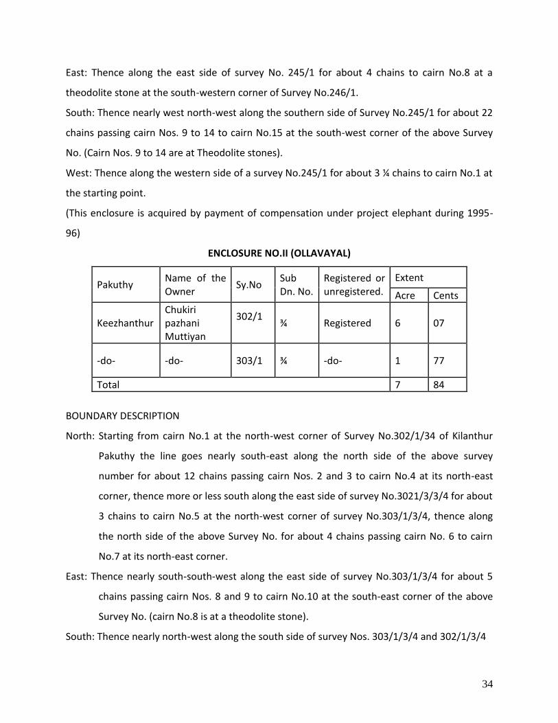
ENCLOSURE NO.II (OLLAVAYAL)
Pakuthy Name of the Owner
Sy.No Sub Dn. No.
Registered or unregistered.
Extent
Acre Cents
Keezhanthur Chukiri pazhani Muttiyan
302/1
¾ Registered 6 07
-do- -do- 303/1 ¾ -do- 1 77
Total 7 84
BOUNDARY DESCRIPTION
North: Starting from cairn No.1 at the north-west corner of Survey No.302/1/34 of Kilanthur
Pakuthy the line goes nearly south-east along the north side of the above survey
number for about 12 chains passing cairn Nos. 2 and 3 to cairn No.4 at its north-east
corner, thence more or less south along the east side of survey No.3021/3/3/4 for about
3 chains to cairn No.5 at the north-west corner of survey No.303/1/3/4, thence along
the north side of the above Survey No. for about 4 chains passing cairn No. 6 to cairn
No.7 at its north-east corner.
East: Thence nearly south-south-west along the east side of survey No.303/1/3/4 for about 5
chains passing cairn Nos. 8 and 9 to cairn No.10 at the south-east corner of the above
Survey No. (cairn No.8 is at a theodolite stone).
South: Thence nearly north-west along the south side of survey Nos. 303/1/3/4 and 302/1/3/4

35
for about 11 ¾ chains passing cairn Nos. 11 to 15 to cairn No.16 (cairn nos. 12 and 15
are at theodolite stones).
West: Thence nearly north-north-west along the west side of survey nos. 302/1/3/4 for about 7
¼ chains passing cairn No.17 to cairn No.18; thence nearly north-east along the west
side of the above Survey No. for about 2 ¼ chains to cairn No.1 the starting point on the
north boundary (cairn No.17 is at a theodolite stone).
ENCLOSURE NO.III
Pakuthy Name of the Owner Sy. No. Registered or unregistered
Extent
Acre Cents
Marayoor
Karuppan Chanthan, Karuppanan, Pazhani, Pazhani, Karuppanan, Pazhanilinkdan, Karupan pazhani, Chuppayan
238/1/3 Registered 2 76
BOUNDARY DESCRIPTION
North: Starting from cairn No. 1 at the theodolite stone at the North-West corner of Survey
No.238/1/3 of the Marayur pakuthy the line goes nearly east along the north side of the above
survey No. for about 5 ½ chains to cairn No. 2 at its north-east corner at a theodolite stone.
East: Thence along the east side of the same survey No. first nearly south for about 2 chains to
cairn No.3 at a theodolite stone and then nearly south – south-west for about 5 ¾ chains to
cairn No.4 at the theodolite stone at the south-east corner of the Survey No.
South: Thence nearly south-west along the south side of the survey No.2 chain to cairn No.5 at
the theodolite stone at the south west corner of the Survey No.
West: Thence nearly north-north-west along the west side of the Survey No. for about 7 ¼
chains passing cairn No.6 at a theodolite stone to cairn No.1 at the starting point on the
northern boundary.
(This enclosure does not exist as per field conditions)

36
ENCLOSURE NO IV
Premises and land occupied by the P.W.D coolly line adjoining the eastern side of the
northern outlet road at the 35 mile 1st
quarter and about 5 chain north-east of the 34th
mile
stone.
Pakuthy Name of the Owner Sy.No. Registered or
unregistered.
Extent
Acre Cents
Marayur
Premises and land
occupied by the
P.W.D Coolly line.
Portion of
238/1/1 Unregistered 0 50.50
BOUNDARY DESCRIPTION
North: Starting from Cairn No. 1 at the north west corner of the Enclosure, the line goes nearly
east for 2 ¼ chains to Cairn No. 2 at its north east corner.
East: Thence nearly south for 2 ¼ chains to cairn No. 3 at its south east corner
South: Thence nearly west for 2 ¼ chains to cairn no. 4 at its south west corner.
West: Thence nearly north for 2 ¼ chains to cairn no. 1 the starting point on the northern
boundary
ENCLOSURE NO V
Premises and land occupied by the tothering shed for bulls adjoining the northern outlet
road at the 31st Mile 3rd Quarter under the charge of the PWD.
Pakuthy Name of the
Owner
Sy.No. Registered or
unregistered.
Extent
Acre Cents
Marayur Premises and land
occupied by the
P.W.D as tothering
shed
Portion of
238/1/1
Unregistered 0 50.50

37
BOUNDARY DESCRIPTION
North: Starting from Cairn No. 1 at the north west corner of the Enclosure, the line goes nearly
east for 2 ¼ chains to Cairn No. 2 at its north east corner.
East: Thence nearly west for 2 ¼ chains to cairn No. 3 at its south east corner
West: Thence nearly north for 2 ¼ chains to cairn no. 1 the starting point on the northern
boundary
South: Thence nearly west for 2 ¼ chains to cairn no. 4 at its south west corner.
PUBLIC RIGHTS
The following roads and footpaths are also admitted within the Reserve for the use of
public and the holders of lands admitted inside the Reserve:-
1. The northern outlet road from 29th Mile 1st Quarter at Cairn No: 54 on the left bank of the
Natchimuthu Odai to the Travancore boundary at Chinnar near Cairn No. 25
The total width allowed for the road including all the quarries necessary for the use of the PWD
and the space for cutting north for maintenance of the road is 1 chain (66 feet i.e., 33 feet on
the upper side and 18 feet for the road way proper, side rains etc and 15 feet on the lower
side).
Description: The above road enters the Reserve between cairn nos 53 and 54 at the 29th Mile
1st Quarter on the outer boundary of the Reserve and goes more or less in a north easterly
direction for about 8 ½ miles and leaves the Reserve between cairn nos 25 and 26 on the
northern boundary.
2. A ROAD FROM THE EXCISE QUARTERS TO THE PWD CAMPSHED
The length of the road passing through the Reserve is about 20 ½ chains.
Description: Starting from a point about 170 links east of cairn no. 18 on the outer boundary of
the Reserve the road goes first south and then north easterly direction for about 20 ½ chains
and leaves the Reserve between cairn nos 24 and 24 A.
3. THE FOOTPATH STARTING FROM CAIRN NO. 16 OF THE OUTER BOUNDARY AND GOING TO
CAIRN NO. 8 OF THE ENCLOSURE NO. I
(This right can be excluded since the enclosure is acquired)

38
The total length of the footpath is about 130 chains, and the uniform width 5 feet.
Description: Starting from cairn no. 16 of the outer boundary of the Reserve the footpath goes
westwards through the Reserve along the southern side of Sy. No: 257/1/1 northern side of Sy.
No: 238/1 and southern sides of Sy. Nos. 250/1, 248/1, 247/1, 246/1 and 245/1 for about 130
chains and meets cairn no. 8 at the south east corner of enclosure no. I.
4. THE FOOTPATH LEADING TO ENCLOSURE NO: III
(This right can be excluded as the enclosure does not exist)
The total length of the footpath is about 8 ¼ chains and the uniform width 5 feet.
Description: Starting from cairn no. 72 on the outer boundary of the Reserve the footpath goes
in a north easterly direction for about 8 ¼ chains and enters the enclosure no. III at cairn no. 1
at the North West corner of the enclosure.
5. THE FOOTPATH LEADING TO ENCLOSURE NO: II
The total length of the footpath is about 3 chains and the uniform width 5 feet.
Description: Starting from cairn no. 15 on the southern boundary of the enclosure the footpath
goes in a south western direction for about 3 chains to Vannanthorai River.
OTHER RIGHTS
1. The rights allowed to Hillmen under rule (rule not legible in the notification available) 4-12-
1911 as per Section 60 of the Forest Act are allowed to the headman and members of the
hillmen settlements in the Reserve.
2. Government in G.O. (Ms) 642/63 Agri. Dated (date not legible in the notification available)
1963 has ordered to transfer 110 acres of land at Champakad to Harijan Department.
3.7.3. Illegal activities
3.7.3.1. Hunting
There is no history of game hunting
3.7.3.2. Poaching
There have been only two wildlife related cases in the last 5 years, one an attempt to capture
and transport a star tortoise and another poaching of a Flying Squirrel. In both these cases

39
tribes within the sanctuary were involved. There is no serious problem of poaching but strict
monitoring of the area need to be carried out.
Table 3: Details of Poaching cases for the period from 2002 to 2011
Sl. No Date of offence No. of accused Description
1 29.10.2009 5 Attempt to capture and transport a star tortoise from Chungum area.
2 27.06.2010 5 Poaching a flying squirrel from Thengamala area.
3.7.3.3. Illegal cutting of trees
The illegal cutting of trees from the sanctuary is related mainly with sandal wood and the same
is dealt with separately. The details of illegal cutting of trees other than the sandal wood tree
are shown below (Table 4).
Table 4: Details of illegal cutting of trees other than sandal wood for the last 10 years
Sl. No Date of offence No. of accused value of
seizures(Rs.) Loss(Rs.)
1 31.08.2003 3 1500.00 2500.00
3.7.3.4. Sandal Protection
Illegal felling of Sandal wood trees is one of the major problems in the management of the
Sanctuary. The presence of Sandal wood trees is attracting smugglers from both inside and
outside the state. The tribes from the Tribal settlements within the Sanctuary as well as from
the settlements in the periphery of the sanctuary get involved with sandal offences. The major
problem in effective protection is the interstate boundary which is used by the smugglers as
well as the tribes in and around the sanctuary.

40
The details of Sandal offences for the past 10 years is given below
Table 5: Details of Sandal Offences for the past 10 years
YEAR No. of case
booked
Thondy Seized
Sandal wood (kg)
Particulars of Vehicle seized, if
any
Approximate value of
materials seized (Rs.)
2002 47 5786.00 9 1691400
2003 29 3006.00 4 1062600
2004 27 2202.00 5 812800
2005 33 1902.00 1 599800
2006 14 431.00 1 148800
2007 08 98.00 0 64000
2008 18 207.00 0 207000
2009 21 749.00 1 617200
2010 18 122.75.00 1 300500
2011 12 51.00 0 102000
Sandal Enumeration Details
For better management and protection the sandal regeneration area is divided into 5 blocks,
namely Alampetty Block- I, Alampetty Block- II, Karimutty Block-I, Karimutty Block-II, Palapetty
and Vannamthura Block.Sandal enumeration was conducted for the first time in 2001. There
were a total number of 4116 trees enumerated that were having a GBH of 30 cm at that time.
Sandal regeneration is found profusely in an area of about 343.1 hectors. As per the
enumeration conducted on February 2008 there were 4183 trees having GBH more than 30 cm.
Of it 12 trees which was situated in the IB compound of Marayoor was transferred to Marayoor
range on 06.03.2009.
A re- enumeration of sandal trees in Chinnar Wildlife Sanctuary was conducted during 2011 and
was completed by December 2011. The details of the same are incorporated in the table below.

41
Table 6: Abstract of Sandal Enumeration conducted on 2011
Alampetty
Block- I Alampetty
Block- II Karimutty
Block-I Karimutty Block- II
Palappetty &
Vannamthura Total
1 Area of the block (in Ha) 7.700 85.000 79.300 29.100 142.000 343.100
2 Periphery (in Km) 1.500 7.000 7.600 3.100 11.000 30.200
3 Enumerated on 2008 Feb 244 2254 574 352 747 4809
4 Enumerated on 2010 (Palapetty Settlement)
638
5 Lost in Forest Offence between 2008 Feb and 2011 Dec
0 22 22 11 15 70
6 Old trees enumerated on 2011 December
244 2232 552 341 1370 4739
7 Newly Enumerated on 2011 December
35 32 12 37 130 246
8 Present No. of Trees 279 2264 564 378 1500 4985
Protection strategy including protection units, No. of watchers etc
Sandal Regeneration Blocks
For an easy and effective sandal protection the sandal regeneration area is surveyed and
divided into various blocks. The tree located in each block is enumerated and the sandal
enumeration register is maintained. All changes caused due to offences are incorporated in the
register then and there itself.
Protection camps
Protection camps are conducted regularly in all the sandal regeneration blocks. In addition
protection camps are conducted at the interstate boundary area such as Chungam and
Churulipetty too. The details of the protection camp are explained below.
Table 7: Details of protection camps
Sl. No
Name of camp Area covered Sandal Block No. of staff and watchers
1. Vannamthura Vannamthura Puthuvettu kalkinar
Palapetty -
Vannamthura
Forester- 1 Forest Guard – 2 Watchers- 10
2. Palapetty Palapetty Palapetty - Forest Guard – 2

42
Indankadu Pullukadu Anakkunnu
Vannamthura Watchers- 12
3. Alampetty Alampetty Jallimala Karimutty
Karimutty- I&II Forester- 1 Forest Guard – 3 Watchers- 14
4. Vazhathura Alampetty Jallimala Karimutty
Alampetty-I&II Forester- 1 Forest Guard – 3 Watchers- 16
5. Churulipetty
/Chinnar Churulipetty Karimala
Interstate Forester- 1 Forest Guard – 3 Watchers- 6
6. Chungam Chungam Thenakkadu
Interstate Watcher- 2
Patrolling during day and night hours are conducted regularly in the above said areas. Apart
from regular field perambulation road patrolling is also conducted during day and night hours.
In addition the border check post functioning at Chinnar is also vigilant round the clock. All the
vehicles coming in an out of the sanctuary is checked properly. A checking station also functions
at Karimutty from 6 pm to 6 am.
3.7.3.5 Illegal removal of NWFP
NWFP is collected mainly by the Tribes settled within the Sanctuary. The main products include
Fire wood, Honey, Gooseberry etc. Collection of NWFP by persons other than tribes of the
sanctuary has not been observed. The quantity of materials collected by the tribes has not been
studied
3.7.3.6. Ganja cultivation
There have been instances of Ganja cultivation in the past as some of the remote areas are
vulnerable to ganja cultivation that calls for constant vigil on the part of Park management. The
areas susceptible to Ganja Cultivation are Pothadi, Olikkudy, Puthukkudi, Eruttalakudy,
Mangappara, Koymanchola, Kariveppinchola etc. There has to continuous monitoring of these
areas to prevent instances on ganja cultivation.

43
M
ap
. 8

44
The details of ganja raid conducted during the past 3 years are given below.
Table 8: Details of Ganja raid conducted during 2009 - 2011
YEAR No. of raids conducted
No. of ganja plants destroyed
2009 30 10,846
2010 23 1,860
2011 20 7,20
3.7.3.7. Encroachment
The boundary is vague in Njavala – Ollavayal area. The status of the land occupied by non tribes
at Njavala is uncertain. The land rights and resource rights under the Tribal Rights Act are
pending settlement in 8 tribal settlements.
3.7.3.8. Live stock grazing
Livestock belonging to the tribes in the settlements, graze inside the Sanctuary. Apart from this,
cattle and goats belonging to outside settlements like Karimutty, Puravayal, Vannamthura etc.
also graze inside. Agencies like the Panchayat supply cattle to the settlements and cattle are
considered by the tribes as a dependable source of income in times of emergency. Sale of cattle
brings in immediate returns without any investment. Cattle from outside are not properly
controlled at present because there is no infrastructure like cattle pound to implement the
provisions of the cattle trespass act. There is marked degradation of the forests surrounding the
hamlets with high level of cattle pressure. No study has been done to assess and quantify the
impact of grazing on the ecosystem as a whole. The presence of cattle distributed all over the
Sanctuary is a potential threat for outbreak of diseases like foot and mouth, anthrax etc.
Vaccination of Cattle against FMD is conducted every year with the support of the Animal
Husbandry department but to a limited success due to the non co-operation of tribes.
3.7.4. Wild fires
As Chinnar has a different pattern of rainfall, the fire season does not correspond to areas
elsewhere. The dry season extends well into the south west monsoon period in most of the

45
areas other than the montane vegetation of the high altitude zones. The current practice
involves total protection from fire by taking fire lines and engaging fire protection mazdoors.
Fire protection has to be done from February to August, in the lower reaches of the Sanctuary
taking in to consideration the climatic conditions prevailing. There is involvement of EDC’s in
fire protection activities. Fire management plans are prepared by the EDC’s and protection
activities in areas adjoining to each tribal settlement is entrusted to that particular EDC. Fire
gangs are engaged exclusively from among the tribes only.
Table 9: Details of forest fire occurrence for the past 5 years
Date of Occurrence of fire
Location Extent
Name Longitude Latitude
01.03.2009 Puthukudy (Agricultural land of tribes)
2 ha
21.03.2010 Ollavayal 4 ha
30.03.2011 Vanchikulam 10.31917 10.31917 5 ha
08.05.2011 Thengamala 10.27781 77.22105 25 ha
20.08.2011 Therumala 10.32482 77.16296 10 ha
3.7.5. Insect attacks and pathological problems
Insect attacks and pathological problems are not reported
3.7.6. Wildlife Health
The presence of cattle on the fringes poses the threat of outbreak of foot and mouth disease
and other communicable diseases. The tribal settlements have large number of cattle and all
this could be a potential threat to the Sanctuary. The mules used for transportation of goods
may also cause communicable diseases to wildlife.
3.7.7. Inter agency Programs and Problems:
Due to the presence of 11 hamlets inside the Sanctuary, the PA has a history of other
developmental agencies operating inside. The District, Block and Grama Panchayats operate
independently within the hamlets. There are 2 Grama Panchayats having jurisdictions over the
PA. Their planning is done independently and this creates friction during implementation
period. Other agencies like Tribal Dept. and Agriculture Dept. also act independently. Social

46
service organizations also operate. At present, there is no system for integrating and
dovetailing the activities of different agencies.
3.8. Eco-tourism
The eco tourism activities were initiated in the PA during 2002-03. The programmes offered as
part of eco – tourism include trekking programmes and night halt programmes. These
programmes are operated by professional EDC groups which were formed from the tribal EDC’s
exclusively for eco tourism operations. The programmes are designed and operated so as to
reduce stake holder pressure on the Protected Area by providing alternate employment to
dependent community members. It is also designed to provide for presence of protection
personnel in sensitive areas as a deterrent to offences.
Presently three Professional EDC groups are functioning in the PA. They are Champakkad Tribal
Trekkers EDC, Eachampetty TTEDC and Alampetty TTEDC.
Eco tourism activities are operated from two points, at Chinnar which is the entry point to the
sanctuary from the Tamilnadu side and at Alampetty about 8 Km from Marayoor Town. The
programmes offered at Chinnar includes visit to watch tower, river side trekking along Chinnar
river, Trekking to Churulipetty and night halt at tree top machans and log houses. At Alampetty
trekking to Thoovanam water falls and stay at log houses are offered as part of eco tourism
activities.
Infrastructure for Eco – tourism activities:
1. IB and dormitory at Chinnar.
2. Amenity centre at Chinnar – functions as dormitory, refreshment centre, information
centre etc.
3. Log houses at Koottar, Churulipetty, Pambar, Thoovanam
4. Tree top machan at Karakkad, Koottar
5. Vasyapara camp shed.

47
The programme is functioning in a benefit sharing manner. The salaries to the guides are based
on the income generated through the various activities. A part of the income is set aside for
community development activities.
The tribes functioning as guides were given a basic training during the initial stages of the
programme. Apart from that their only training is limited to exposure from visits to other eco
tourism centers within the state. The knowledge and skill level of the guides need to be
improved by providing suitable training so that they along with earning their livelihood can act
as messengers of nature conservation and impart nature awareness to visitors.
3.8.1. Visitor Management
Information providing mechanisms are functioning at the Wildlife Warden’s office at Munnar
and the Asst. Wildlife Warden’s office at Marayoor. EDC offices function at Chinnar and
Alampetty to provide necessary help to the visitors. The number of visitors to the PA is not in a
very large scale. The visitors are including a few numbers of foreigners as well. The details of
visitors and income generated during the past years are given below:
Table 10: Details of Visitors and income generated from eco tourism activities
Year No. of Visitors
Govt. Revenue EDC income Indians Foreigners
2002 - 03 219 76 6130 19700
2003 - 04 2599 707 68156 230060
2004 - 05 2890 1016 84170 307125
2005 - 06 2211 1158 91940 323835
2006 - 07 3233 1563 112840 444695
2007 - 08 5120 2723 150640 527712
2008 - 09 5889 2270 194485 1104420
2009 - 10 5860 2085 190215 1192495
2010 - 11 8335 2345 247710 1545885

48
3.8.2. Conservation Education
As a part of conservation education, Nature Camps are conducted regularly for School/College
Students and for NGO’s. The nature camps are organized in the Nature Education Centre at
Chinnar. The centre is equipped with generator, LCD Projector, Television, DVD Player etc.
There is lack of trained personals for imparting nature education. Presently the nature
education sessions are conducted by the staff of the PA.
Table 11: Details of Nature Camps Conducted in Chinnar
Year No. of Nature Camps No. of Participants
2004 - 05 58 1860
2005 - 06 43 1696
2006 – 07 18 774
2007 – 08 42 1286
2008 – 09 36 1320
2009 – 10 37 1515
2010 - 11 34 1344
A nature education interpretation centre is functioning at Karimutty, near the entrance of the
Sanctuary. But the centre is not yet completed. This facility has to be developed during this plan
period.
3.9. Research, monitoring and training
3.9.1. Research & monitoring
Various studies have been carried out in Chinnar Wildlife Sanctuary. Most of the studies focus
on ecological aspects. The studies were conducted on subjects like the Flora of the Sanctuary,
natural salt licks of the area, plant diversity, habitat utilization of larger mammals (Jayson and
Ramachandran, 1996) etc. Studies were also done on the cropping systems of the tribes, social-
ethno botanical aspects (Nair, K.K.N and R.Jayakymar, 1998, 1999) etc. Some of these studies
revealed the occurrence of rare and endangered fauna and flora like starred tortoise, saw
scaled viper, rusty spotted cat, Albizia lathamii etc.

49
Continuous monitoring of flora and fauna has to be done and the same shall be incorporated in
the plan.
3.9.2. Training
The staffs of the PA area are not provided any specialized training. The front line staffs receive
general forestry training from forest schools. The staffs are not provided any specialized
training in wildlife management and eco development which forms the key activity of the PA.
Occasional study tours and one day/ two day workshops are conducted in a limited manner.
Absence of any specialized training for the front line staff reduces their efficiency. The daily
waged watchers who play a significant role in protection and management of the PA lack
training.
3.9.3. Census
Tiger census, Elephant census and wildlife census are conducted along with the other forest
areas of the State. The following data are appended in tables for reference. The data is for
Munnar Wildlife Division as a whole and hence applicable to Chinnar Wildlife Sanctuary as well.
1. Population estimation of major mammals in the Forests of Kerala conducted in 1997
by Kerala Forest Department and Kerala Forest Research Institute
Species No.
sighted Density (sq.km) % CV
Dung / pellet Density
(sq.km)
Elephant Density (sq.km)
Bonnet Maccaque 48 1.22 78.72 Common Langur 28 0.71 47.03 Elephant 48 1.22 53.35 967.18 0.225
Guar 18 2.82 49.78 Sambar 14 0.36 58.43 Spotted Deer 49 1.24 65.8 Barking Deer 5 0.13 33.43 Mouse Deer
371.08
Wild boar 17 0.43 74.3 Malabar giant squirrel 5 0.13 43.44 Porcupine
753.28
Common palm Civet
646.62 Sloth bear
28.89

50
2. Population estimation of major mammals in the Forests of Kerala conducted in
2002 by Kerala Forest Department and Kerala Forest Research Institute
Species Density/Sq.Km Method
Elephant 0.29
Block Count
Gaur 0.45
Sambar 0.11
Spotted Deer 0.43
Wild boar 0.75
Malabar Giant Squirrel 0.03
Table 12: Population estimation of Major Mammals in Forests of Kerala
j) Population estimation of Wild Elephants in the Elephant reserves of Kerala conducted by
Kerala Forest Department, Periyar Foundation and Kerala Forest Research Institute
Year Density/Sq.Km Method
2005 1.14
Dung Count 2007 0.52
2010 0.72
Table 13: Details of Elephant Census
3.10. Wildlife conservation strategies & evaluation
The strategy of conservation is firmly based on protection especially focusing on sandalwood.
The eco development programme has created better relationship with the communities, but
this has not been effectively built into the protection network. Because of the imperatives of
protection, other activities like nature education, eco development, monitoring etc. are lagging
behind.
Fire protection is given high importance considering that Scrub jungle and dry deciduous forest
constitute nearly fifty percent of the sanctuary area. Eco – development committees play an
important role in fire prevention and protection.
There is no institutional arrangement to monitor the implementation of the Management Plan
and to evaluate the impacts of management.

51
3.11. Administrative set up
Chinnar Wildlife Sanctuary is one Range of Munnar Wildlife Division, with Headquarters at
Munnar which is 60km from Chinnar, the major centre of the Sanctuary. The office of the
Assistant Wildlife Warden is at Marayoor. The Sanctuary has staff strength of One Deputy
Ranger, Three Foresters, Sixteen Forest Guards and one Driver. Additionally, watchers on daily
wages are engaged for various purposes like protection, monitoring, fire control etc. At present
the entire Sanctuary is under one forest station, which is located at Karimutty. There is no
separate staff for eco development apart from a social worker temporarily engaged for that
purpose. Presently Kambakkallu Forest Station, which comes under Kurinjimala Sanctuary, is
under the administrative control of the Chinnar Wildlife Sanctuary. The staff of the Kambakallu
Forest Station is deputed on working arrangement to Chinnar to assist in management of the
PA.
TABLE 14: Staff Strength in Chinnar Wildlife Sanctuary
SL.NO CATEGORY SANCTIONED
STRENGTH
STAFF IN
POSITION
1 Assistant Wildlife Warden 1 1
2 Deputy Ranger 2 2
3 Forester 7 7
4 Forest Guards 32 26
5 Clerk 1 1
6 Peon 1 1
7 Driver 1 1

52
3.12. Infrastructure facilities
Table 15: Infrastructure Facilities
Buildings
Sl. No Name of Building Remarks
1 Type II duplex at Marayoor Functioning as Range Office & accommodation for office staff
2 Type II Qtrs at Marayoor Accommodation for Asst. Wildlife Warden
3 Type II Qtrs at Chinnar Accommodation for Forester
4 Type II duplex at Chinnar Accommodation for Check post staff
5 Type II duplex at Chinnar Accommodation for Lady watchers and Forest Guard
6 Type II duplex at Chinnar Keeping as store room for forestry work equipments.
7 Information centre cum Cell building at Chinnar Functioning as cell room and accommodation for check post watcher & Dormitory watcher
8 Old office building at Chinnar Unused
9 Old check post building at Chinnar Functioning as Chambakkadu TTEDC office
10 Inspection Bungalow at Chinnar with all furniture and utensils.
Functioning
11 Dormitory at Chinnar with all furniture and utensils.
Functioning
12 Check post building with cross bar at Chinnar Functioning
13 Thondy room at Chinnar Functioning
14 Fabricated Watch Tower at Chinnar Functioning
15 Fire Watch Tower at Jallimala with Alampetty TTEDC
16 Nature Education centre at Chinnar Functioning
17 Anti poaching building at Chungam for protection camp

53
18 Steel fabricated shed at Karimala for protection camp
19 Steel fabricated shed at Thengamala for protection camp
20 Anti poaching building at Vannamthura for protection camp
21 Anti poaching building at Alampetty for protection camp
22 Steel fabricated shed at Vazhathura for protection camp
23 Anti poaching building at Palappetty for protection camp
24 Anti poaching building at Kannimar for protection camp
25 Anti poaching building at Kovilpara for protection camp
26 Anti poaching building at Aralippara for protection camp
27 Anti poaching building at Vasyapara for protection camp
28 Anti poaching building at Periyamala for protection camp
29 Anti poaching building at Periyacombu for protection camp
30 Log house at Churulipetty with Chambakkadu TTEDC
31 Log house at Koottar with Chambakkadu TTEDC
32 Log house at Thoovanam with Alampetty TTEDC
33 Amenity center at Chinnar with Chambakkadu TTEDC
34 Old Guard station building (tiled roof) Accommodation for Station staff, Karimutty
35 Old Forest station building (concrete) Accommodation for Deputy Ranger, Karimutty
36 Forest station building, Karimutty Functioning
37 Interpretation center Karimutty with all displays Functioning
38 Fabricated check post and cross bar at Karimutty Functioning
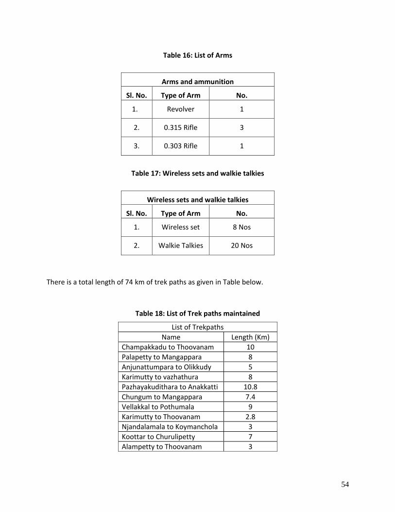
54
Table 16: List of Arms
Arms and ammunition
Sl. No. Type of Arm No.
1. Revolver 1
2. 0.315 Rifle 3
3. 0.303 Rifle 1
Table 17: Wireless sets and walkie talkies
Wireless sets and walkie talkies
Sl. No. Type of Arm No.
1. Wireless set 8 Nos
2. Walkie Talkies 20 Nos
There is a total length of 74 km of trek paths as given in Table below.
Table 18: List of Trek paths maintained
List of Trekpaths
Name Length (Km)
Champakkadu to Thoovanam 10
Palapetty to Mangappara 8
Anjunattumpara to Olikkudy 5
Karimutty to vazhathura 8
Pazhayakudithara to Anakkatti 10.8
Chungum to Mangappara 7.4
Vellakkal to Pothumala 9
Karimutty to Thoovanam 2.8
Njandalamala to Koymanchola 3
Koottar to Churulipetty 7
Alampetty to Thoovanam 3

55
3.13. Communication
The Sanctuary is located 42 km away from Munnar. The head quarters of the Sanctuary at
Marayoor and the Wildlife Warden’s office are having both telephonic, wireless and internet
facilities. Sim cards are issued to all staff of the PA from Guards to Assistant Wildlife Warden.
Mobile connectivity is available in Karimutty region. In Alampetty, Palapetty, Vannanthura
areas of the sanctuary stable connectivity is not available at present. In Chinnar area mobile
phone connectivity is presently not available. A wireless local loop phone is presently made
available to EDC office in Chinnar to facilitate tourism activities. At the present situation
wireless communication network is highly essential for effective protection of the area. The
Forest Station at Karimutty and Check post at Chinnar are having wireless communication
facilities. The wireless tower at Pachapullu facilitates the communication with the filed. The
sanctuary is having its own website www.chinnar.org.
POSTAL ADDRESS
Wildlife Warden
Wildlife Division,
Munnar,
Idukki District,
Kerala.
Pin-685612.
Tel: 91-4865-231587 (Office)
Mob: 9447979093
E-mail: [email protected]
E-mail: [email protected]
Assistant Wild life warden
Chinnar Wildlife Sanctuary
Marayoor P.O
Idukki District,
Kerala.
Pin-685620.
Tel: 91-4865-252039 (Office)
Mob: 8547603220
E-mail: [email protected]
E-mail: [email protected]
3.14. Summary of threats to wildlife
Sandal wood smuggling is a major problem faced by the PA. The entire resources and man
power is spent on tackling this issue. The presence of tribal hamlets within the sanctuary and
the open interstate boundary poses difficulty in tackling this issue. Only if this issue is tackled
effectively the resources and man power can be utilized for other management activities in an
efficient manner.

56
Collection of NWFP especially firewood is a major problem with the sanctuary. The tribes
depend on firewood collection not only for domestic needs but also for distillation of lemon
grass oil. This practice leads degradation of forest area near to tribal settlements.
The vagueness in the boundary at Njavala - Ollavayal is a major issue. The present status, of
land occupied by non tribes at Njavala is not clear. This issue has been mentioned in the
previous plan too, but much progress was not achieved in demarcating the boundary at this
area.
Cattle grazing is a major management issue. The tribes in all the eleven settlements rear cattle
and goat. This leads to degradation of vegetation.
The developmental impacts are mainly due to widening of PWD road resulting in restriction to
animal movement.

57
CHAPTER 4
THE PROTECTED AREA AND THE INTERFACE LAND USE SITUATION
4.1. The existing situation in the zone of influence
There are 11 settlements within the Sanctuary, of which 7 belongs to Muthuvans and the rest
to Hill Pulayas. The two tribal communities - Muthuvans and Hill Pulayas differ from one
another in social, cultural and anthropological aspects. Eco – development committees are
functioning in all the Eleven Tribal Settlements.
The Muthuvans practiced shifting cultivation till a decade ago but after 1984 when the Wildlife
Sanctuary came into existence, they were forced to take to sedentary agriculture. Lemon grass
cultivation is the prominent livelihood option for the Muthuvan Tribes. Apart from lemon grass
cultivation they cultivate vegetables, Ragi etc but these are for own use only and not for sale.
Muthuvan settlements in the Sanctuary are located mostly in the difficult terrain and relatively
higher rainfall zones. They also used to indulge in Ganja cultivation. Continuous and strict
monitoring of the areas has reduced the incidence of Ganja Cultivation.
Hill Pulayas are found only in the Idukki District in Kerala. They are part of the larger population
of Hill Pulayas in Palani hills. They are also called Kurumba Pulaya, Karaivazhi Pulaya and
Pambar Pulaya. Although Tamil speaking, the Hill Pulayas of Chinnar are well versed in
Malayalam too. Hill Pulayas are believed to be a warrior community that migrated to forested
regions following the losses in some ancient wars. They were basically a hunter-gather
community possessing rich folklore on landscape, vegetation, animals and other local
resources. Hunting-gathering activities not only helped them to acquire knowledge on spatial
and temporal distribution of resources but also helped them to accumulate good amount of
knowledge on landscape and other resource.
Hill Pulayas of Chinnar work as wage labours in and around Marayoor. They practice agriculture
in a very limited manner. Their main occupation is Goat and cattle rearing. Though forbidden by
Sanctuary rules, it is still widely practiced. Majority of the daily waged watchers employed with

58
the Forest Department also belongs to this community. After the initiation of Eco – tourism
activities few number of Hill Pulaya Tribes are also engaged as guides in tourism activities.
About 43 persons are working as guides in eco –tourism activities.
Ethno botanical Observations:
Of the total 141 species recorded to be ethonobotanically important, 57 taxa are those used
exclusively by Hill Pulayas and 27 taxa are those related to the traditional life of Muthuvans. At
present tubers of Asparagus racemosus, Dioscorea sp., stem and leaves of Boerhaavia diffusa,
Cassia alata, Cleome viscose, Cleome monophylla and fruits of Canthium caromandelicum, Ficus
recemosa, Garacinia gummi-gutta, Grewia tiliaefolia, Memecylon umbelletum, Mitrephora
heyneana, Opuntia dillenii, Solanum torum, etc. are collected for food or marketed by the Hill
Pulayas. The removal of firewood of species like Albizia odoratissima, Hardwickia binata,
Ixorapavetta, Catunaregam spinosa, Anogeissus latifolia, Cordia gharaf, Diospyros ebenum, D.
ovalifolia, Hopea parviflora etc. for domestic purpose and for distillation of lemongrass oil has
negative impact on the natural flora of the area.
The details of settlements in Chinnar Wildlife Sanctuary are given in Table below.
Table 19: Details of Tribal Settlements
Settlement Name of
Tribe Name of Village
Name of Panchayat
Area of settlement
in GPS (Ha)
No. of families
Population
Male Female Total
Alampetty
Hill
pu
laya
Marayoor Marayoor 85.120 54 78 93 171
Eachampetty Marayoor Marayoor 69.901 50 87 80 167
Palapetty Keezhanthoor Kanthalloor 116.200 61 116 121 237
Chambakkad Keezhanthoor Kanthalloor 16.310 54 91 101 237
Total 287.531 219 372 395 812
Vellakkalkudy
Mu
thu
van
s
Marayoor Marayoor 55.870 37 70 79 149
Mangapara Keezhanthoor Kanthalloor 54.000 8 19 10 29
Ollavayal Keezhanthoor Kanthalloor 65.860 72 122 110 232
Thayannankudy Marayoor Marayoor 17.940 23 43 37 80
Olikudy Marayoor Marayoor 308.500 28 50 49 99
Puthukudy Marayoor Marayoor 85.490 41 75 68 143
Iruttalakudy Marayoor Marayoor 124.500 56 123 113 191
Total 712.160 265 502 466 923
Grand total 999.691 484 874 861 1735

59
4.1.1. PA People Mutual impact
Being inside the forests, the 11 settlements have significant impact on the forests around and
vice versa. After the declaration of the sanctuary tribals have taken up sedentary agriculture,
but there is no serious restraint on the activities of the people in terms of meeting their
necessities like firewood collection, cattle grazing, NWFP collection etc.
Lemon grass cultivation still remains the major source of income and this is a great strain on
available biomass. The collection of NWFP is not always sustainable and at times positively
destructive as the mango collection from the riverine forests that harbour the highly
endangered Grizzled Giant Squirrel. There is intense grazing pressure on the dry forests around
settlements leading to degradation of forests and soil.
Other settlements outside the PA are also exerting pressure on forests. They graze cattle inside
the PA. There is one nontribal settlement namely Njavala within the PA on the periphery and its
impact is yet to be assessed. Also the status of this settlement remains vague. People from the
forest villages of Talinji and Manjampatti in Tamil Nadu use the PA routes for movements and
transport of provisions on mule backs as these routes provide easier means of access.
Due to the awareness activities of eco development and support to agriculture, there is
reduction in dependency. But this may not be to the desired extent. Several activities had been
taken up as part of eco development activities like providing seedlings of firewood species,
supply of Gas connection to few house holds in Chambakkad Settlement etc.
4.2. The development programmes and conservation issues
4.2.1. An evaluation of Government and nongovernmental agencies
Different government and non-government agencies operate in all the settlements inside the
Sanctuary. The activities of other agencies are at present planned and carried out without the
knowledge or permission of Forest Department. The appropriateness of the activities in the
context of PA is to be ensured for which better inter sectoral co-ordination is needed.

60
M
ap
. 9

61
The lack of co- ordination between different agencies leads to paradoxical situations like
proliferation of cattle inside the PA, legally and ecologically un implementable development
schemes prepared by the local bodies etc. The main road that passes through the PA is under
the control of the PWD and activities like widening the road, would lead to problems like
impeding animal movements across the road. The 220kv line has already fragmented the
riverine habitat of the Grizzled Giant Squirrel and the undergrowth clearance will stop the
regeneration from coming up. Investigation for a power project at Marayoor, using the water
from Pambar, still goes on.
4.2.2. The interplay of market forces and their impact
For the people inside the PA, Marayoor controls their economic life as they sell their products
and buy necessities from Marayoor. The long existing exploitative relationship leading to debt
trap still continues. The cropping system followed by the tribes gives pre dominant importance
to cultivation of lemon grass rather than to cultivation of food crops. This practice is due to
various reasons like scarcity of water, low fertility of the soil, presence of wild animals etc. This
practice has led to lack of food security and the tribes need to depend on the local merchants
to meet their needs. Thus they are engulfed in a long lasting dept trap.
The eco development programme was initiated for reducing the dependency of people on PA
resources by providing them financial and technical assistance for alternate means of
livelihood. This objective is still not achieved. The intervention of EDC’s in the aspect of
protecting the interests of tribes is very limited. The present activity ends up in providing loans
to tribals with little or no effort in re – couping the amount provided as loan. Hence PFM and
eco development activities needs a re-look and are to be revamped.
4.2.3. Eco development initiatives
All the 11 tribal settlements within the Sanctuary were brought under Eco development project
under the Kerala Forestry Project. The EDC’s are functioning even after the end of the project.
But no major activity is being initiated by the EDC’s. Community support programmes are run
with the Community Development Fund received from the Anaimudi Forest Development
Agency, to which the EDC’s in Chinnar Wildlife Sanctuary are affiliated.

62
In addition to the tribal EDC’s three Professional EDC’s namely Champakkad TTEDC, Alampetty
TTEDC and Eachampetty TTEDC are functioning. The Eco – Tourism activities in the protected
area are operated by these committees.
The major involvement of the EDC’s is seen in Fire Protection activities. A contribution is
received by each EDC as Community Development Fund from Anaimudi FDA every year. This
amount is utilised to provide loans to EDC members for income generating activities. Apart
from these and the eco tourism initiatives no major activity is taken up by the EDC’s.
There are several reasons for the set back faced by eco development activities which can be
identified as follows:
1. Lack of dedicated staff trained in eco development activities.
2. A team could not operate exclusively for eco development. Eco development
programme was just another part of routine duty.
3. Lack of monitoring mechanism regarding the implementation of activities as specified in
the micro plan of EDC’s.
Considering the various reasons for the lethargy in the activity of Eco Development Committee
new strategies are formulated in this plan.

63
4.2.4 Implementation of Forest Rights Act.
The protected area has 11 tribal settlements and the implementation of Forest Right act has
serious implications on the management of the sanctuary. Hence this has to be monitored in an
efficient manner. The present stage of implementation of Forest Right Act is given below.
Settlement Name of Tribe
Status of implementation of FRA Status of Boundaries
Alampetty
Hill
pu
laya
Survey completed rights issued to families
Agricultural lands are demarcated by constructing cairns. But the human habitation area is not demarcated.
Eachampetty Survey completed and rights issued to families
Well demarcated by construction of cairns
Palapetty Survey completed. Rights not issued as decision has to be taken regarding the Sandal trees within the settlement.
Well demarcated by construction of cairns
Chambakkad Survey completed and rights issued to families
Well demarcated by construction of cairns
Vellakkalkudy
Mu
thu
van
s
Survey not done due to the demand from the tribes that instead of individual rights the entire settlement has to be surveyed and demarcated.
Area is partially demarcated
Mangapara Survey not done Not demarcated
Ollavayal
Survey not done due to the demand from the tribes that instead of individual rights the entire settlement has to be surveyed and demarcated.
This settlement has extended well beyond the cairns constructed.
Thayannankudy Survey of the Settlement completed. Rights were not accepted by the people as they demanded more land.
Human habitation area at Thayannamkudi is completely demarcated by construction of cairns. The cultivation lies in Mulangamutti area close to vellakkalkudi.
Olikudy
Survey not done due to the demand from the tribes that instead of individual rights the entire settlement has to be surveyed and demarcated.
Area is not fully demarcated
Puthukudy
Survey not done due to the demand from the tribes that instead of individual rights the entire settlement has to be surveyed and demarcated.
Area is well demarcated
Iruttalakudy
Survey not done due to the demand from the tribes that instead of individual rights the entire settlement has to be surveyed and demarcated.
Settlement area and agricultural fields are separate. The area is well demarcated.

64
PART II
PROPOSED
MANAGEMENT

65
Vision
“Conservation of unique biodiversity with all its ecological, anthropological and archaeological richness managed with the help of the local community”

66
CHAPTER 5
PLAN OBJECTIVES AND PROBLEMS
5.1 Objectives
1. Conserve and maintain diverse habitat and rich biological diversity with special emphasis on
rare, endangered, threatened and endemic species in the unique thorny and riparian forest
ecosystems.
2. Maintain and improve the watersheds of the Wildlife Sanctuary
3. Conserve and maintain the endemic medicinal plants and germplasm of wild cultivars
especially of the dry areas
4. Protect the sites of archeological and anthropological importance
5. Promote environmental conservation awareness
6. Facilitate nature-based regulated tourism and visitor management
7. Strengthen People-PA interface
5.2 Problems in Achieving Objectives Objective – 1: Conserve and maintain diverse habitat and rich biological diversity with special
emphasis on rare, endangered, threatened and endemic species in the unique thorny and
riparian forest ecosystems.
Objective – 2: Maintain and improve the watersheds of the Wildlife Sanctuary
Objective – 3: Conserve and maintain the endemic medicinal plants and germplasm of wild
cultivars

67
Constraints Strategies
Inadequate data base on Grizzled Giant Squirrel, Star tortoise and yellow throated bulbul, tufted grey langur
Carry out intensive studies on Grizzled Giant Squirrel,
Conduct population estimation of Grizzled Giant Squirrel biennially.
Conduct bird census biennially to assess population changes including species composition during the plan period.
Conduct studies on star tortoise and yellow throated bulbul, tufted grey langur
Breaks in canopy of riverine vegetation under 220 KV line & degradation of riverine vegetation
Planting of these fragmented area with short trees like Acacia planiferons
Alteration of nature of forests by soil & moisture conservation activities
Soil & moisture conservation works in pristine dry forests will be taken up based on scientific assessments
Gravity water flow to be utilised for filling up of existing waterholes and dry streams and for providing water to settlements
The existing water supply canal from Churulipetty to Chinnar and the water supply line from Thoovanam to Chambakkad to be maintained
Traffic along Marayoor-Chinnar road
Traffic regulations along the road (restrict night traffic; speed regulations, putting signages, warnings on animal movement locations)
Widening of road, construction of retaining walls along the PWD road
Implement Forest Conservation Act and orders in WP(C) 202/95
Human pressures on the habitats
Conduct survey to demarcate tribal hamlets and settlement of rights under tribal Act.
Explore possibility of relocation of settlements from inaccessible areas to more suitable areas
Integrated land resource development focusing on food security through micro plan activities of EDCs
Vagueness in the boundary of the sanctuary at Ollavayal – Njavala area
Conduct survey to clearly demarcate Ollavayal – Njavala areas
Plantations of exotics Remove plantations of exotics by permitting the tribes to collect firewood from them.
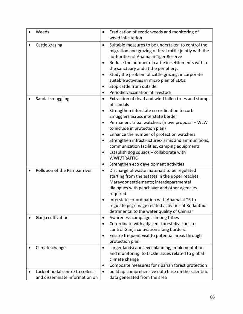
68
Weeds Eradication of exotic weeds and monitoring of weed infestation
Cattle grazing Suitable measures to be undertaken to control the migration and grazing of feral cattle jointly with the authorities of Anamalai Tiger Reserve
Reduce the number of cattle in settlements within the sanctuary and at the periphery.
Study the problem of cattle grazing; incorporate suitable activities in micro plan of EDCs.
Stop cattle from outside
Periodic vaccination of livestock
Sandal smuggling Extraction of dead and wind fallen trees and stumps of sandals
Strengthen interstate co-ordination to curb Smugglers across interstate border
Permanent tribal watchers (move proposal – WLW to include in protection plan)
Enhance the number of protection watchers
Strengthen infrastructures- arms and ammunitions, communication facilities, camping equipments
Establish dog squads – collaborate with WWF/TRAFFIC
Strengthen eco development activities
Pollution of the Pambar river Discharge of waste materials to be regulated starting from the estates in the upper reaches, Marayoor settlements; interdepartmental dialogues with panchayat and other agencies required
Interstate co-ordination with Anamalai TR to regulate pilgrimage related activities of Kodanthur detrimental to the water quality of Chinnar
Ganja cultivation Awareness campaigns among tribes
Co-ordinate with adjacent forest divisions to control Ganja cultivation along borders.
Ensure frequent visit to potential areas through protection plan
Climate change
Larger landscape level planning, implementation and monitoring to tackle issues related to global climate change
Composite measures for riparian forest protection
Lack of nodal centre to collect and disseminate information on
build up comprehensive data base on the scientific data generated from the area
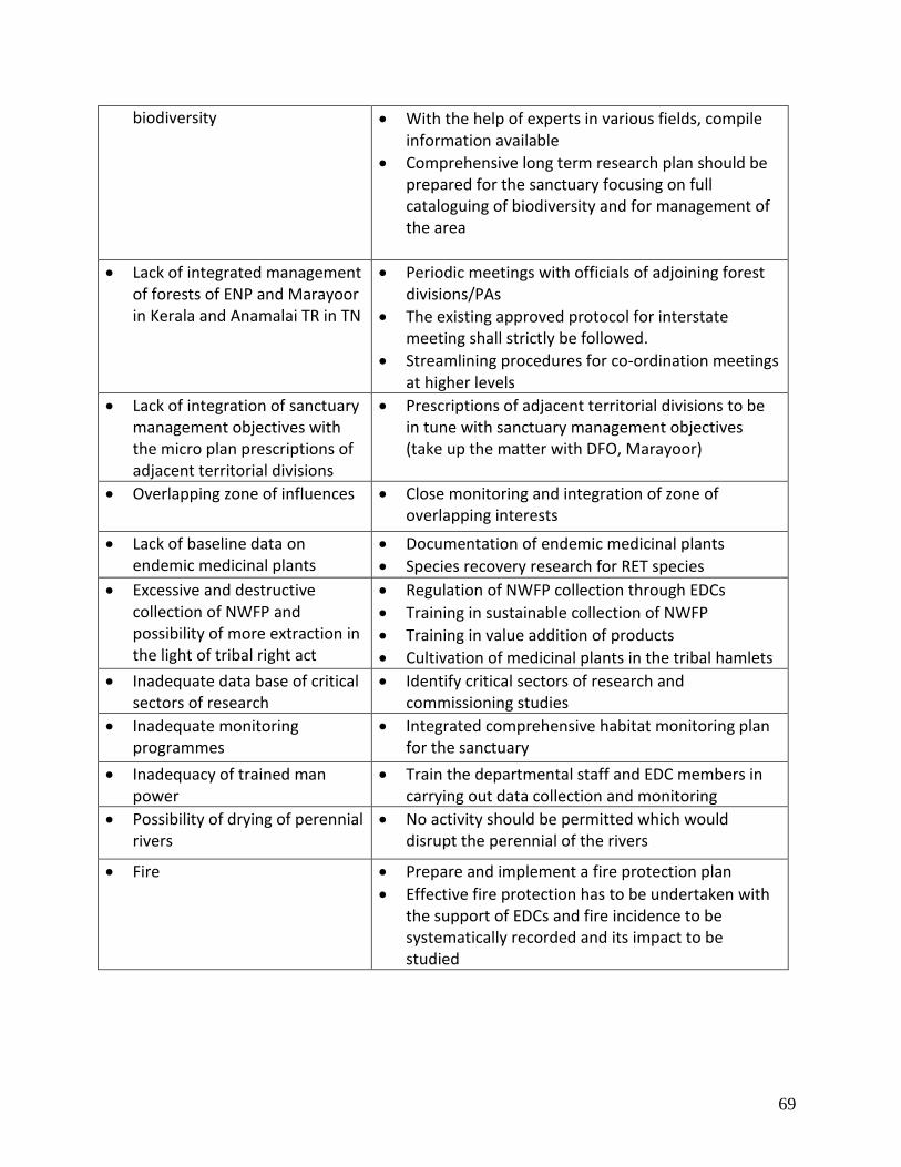
69
biodiversity
With the help of experts in various fields, compile information available
Comprehensive long term research plan should be prepared for the sanctuary focusing on full cataloguing of biodiversity and for management of the area
Lack of integrated management of forests of ENP and Marayoor in Kerala and Anamalai TR in TN
Periodic meetings with officials of adjoining forest divisions/PAs
The existing approved protocol for interstate meeting shall strictly be followed.
Streamlining procedures for co-ordination meetings at higher levels
Lack of integration of sanctuary management objectives with the micro plan prescriptions of adjacent territorial divisions
Prescriptions of adjacent territorial divisions to be in tune with sanctuary management objectives (take up the matter with DFO, Marayoor)
Overlapping zone of influences Close monitoring and integration of zone of overlapping interests
Lack of baseline data on endemic medicinal plants
Documentation of endemic medicinal plants
Species recovery research for RET species
Excessive and destructive collection of NWFP and possibility of more extraction in the light of tribal right act
Regulation of NWFP collection through EDCs
Training in sustainable collection of NWFP
Training in value addition of products
Cultivation of medicinal plants in the tribal hamlets
Inadequate data base of critical sectors of research
Identify critical sectors of research and commissioning studies
Inadequate monitoring programmes
Integrated comprehensive habitat monitoring plan for the sanctuary
Inadequacy of trained man power
Train the departmental staff and EDC members in carrying out data collection and monitoring
Possibility of drying of perennial rivers
No activity should be permitted which would disrupt the perennial of the rivers
Fire Prepare and implement a fire protection plan
Effective fire protection has to be undertaken with the support of EDCs and fire incidence to be systematically recorded and its impact to be studied

70
Objective – 4: Protect the sites of archaeological and anthropological importances
Inadequate information Highlight the cultural significance of the sites and documentation of the sites
Lack of awareness on the part of guides and tourists
Create awareness among guides and tourists
Inadequate protection of the explicit sites
Create awareness among tribes regarding the value of the sites.
Objective – 5: Promote environmental conservation awareness
Objective – 6: Facilitate nature-based regulated tourism and visitor management
Lack of visitor management plan
Prepare a comprehensive Visitor management plan and implement
Increasing number of tourists Fix carrying capacity
Depositing solid waste along the road through the PA
Create awareness among visitors
Display sign boards with rules and regulations of PA
Install waste bins in appropriate locations
Carrying out regular cleaning programmes with the support of EDCs
Inadequacy of trained staff Training to staff and EDC members
Objective – 7: Strengthen People-PA interface
Lemon grass cultivation and consequent fuel demand
Plantation of exotics can be used for meeting fuel wood requirement of local community
Providing fuel efficient distillation units to tribes for reducing consumption of fuel wood.
PFM activities along the state border is not integrated between the two states
Joint discussions between the officials concerned and EDCs of two states
11 settlements within the PA have extremely degraded lands
Address through FDA to improve the productivity of the cultivated land
Settling of Land and community rights not completed
Facilitate settlement of rights
Permanent demarcation of the settlements may be carried out by construction of cairns, kayyalas etc.

71
Olikudy – translocation issue Submit proposal for relocation to GoI (Warden to discuss with the stakeholders) high priority
Eucalyptus in settlements
Cultivation of Eucalyptus inside the sanctuary shall be limited only for use of tribes and not for sale.
Cattle grazing Removal of cattle owned by outsiders
Address through FDA and line departments/ Panchayats
Reduce the number of cattle by replacing with high yielding variety
Conduct a carrying capacity study of cattle and fix number of cattle
Cultivation of lemon grass and expansion of lemon grass cultivated areas
Developmental activities through EDCs on the basis of comprehensive eco development plan in which multi departmental co-ordination is ensured
Constitution of an eco development implementation committee for monitoring of interdepartmental developmental activities
Sale of lemon grass oil through eco shops of EDCs
Firewood collection for oil extraction
Explore new technology for extraction (prepare and implement a plan)
Ganja cultivation
Develop and implement a protection plan
Strengthen intelligence network and improve intelligence gathering
Enforce legal provisions
Create awareness among tribes
Zone of influence not demarcated
Revisit of micro plan in the light of settlement of rights
Demarcate zone of influence
Resource dependency to be quantified
Address while revisiting micro plans (also address the issue of lack of reciprocal commitments in some EDCs for sandal protection )
Lack of staff exclusively for eco development activities
Propose for additional staff (address in protection plan, including restructuring of staff deployment)
Lack of eco development micro planning implementation support team
Avail services of support team (MIST) from the division
Capacity building among the staff for taking up the new task of participatory management of forests
Lack of drinking water facilities / water for irrigation
Address through FDA (explore for check dam, awareness for Panchayat / other line departments on FDA and related matters)

72
Isolated settlements in Mangappara and Olikudy
Initiate dialogues with the communities for relocation
Inaccessibility, poverty and backwardness of the tribal hamlets
Site specific comprehensive educational programme to be developed aiming at long term attitudinal shift
Initiate, guide and monitor the educational activities in collaboration with HRWEPA &WWF

73
THE STRATEGIES

74
CHAPTER 6
STRATEGIES
BOUNDARIES, ZONATION, ZONE PLANS AND THEME PLANS
6.1. Boundaries
6.1.1. Legal Boundary
North: Starting from cairn No.1 at the trijunction of the boundaries of Coimbatore District,
Marayoor Pakuthy and Kannan Devan Hills at the North West corner of the Reserve, the line
goes in a nearly north easterly direction for about 5643/4 chains along the Chinnar River to
cairn No.2 at a State Boundary Survey Stone on the bank of the Chinnar River, thence more or
less east- south east for about 2141/4 chains along the above said river to cairn No.3 at the
State Boundary Survey Stone on the bank of the river side of that Survey No. for about 11/4
chains to cairn No.4 at its south west corner. (This is also the Western most point of
S.No.251/1/1). Thence nearly east along the south side of the S.No. 257/1/1 for about 333/4
chains passing cairns No. 5 to 15 to cairn No.16 at its south east corner. Thence nearly south for
about 63/4 chains to cairn 17 thence nearly south for about 63/4 chains passing cairn No.18
and crossing the approach road to the P.W.D. camp shed to cairn No.19 at the right bank of the
thodu flowing to Chinnar River – then nearly north along that thodu for about 103/4 chains to
cairn No.20 at its junction with the Chinnar River (from cairn numbers 16 to 20 the boundary
follows the Western, Southern and Eastern Boundaries of the area allowed for the P.W.D.
excluding the same from the reserve.) thence nearly east along the Chinnar River for about
71/2 chains to cairn No.21, on its bank; thence nearly south east for about 43/4 chains passing
cairn number No.22, 23 to cairn No.24 on the West side of the approach road to the P.W.D.
camp shed; thence east by slightly south for about 3/4 chains crossing the above road to cairn
No.24A; thence nearly east- south east for 1 chain to cairn No.24B; thence nearly north-north
east for 31/2 chains to cairn No.24C, thence east for 3/4 chains to cairn No.24D, thence north
for 11/2 chains to cairn No.24E, thence west for 3/4 chains to cairn No.25; thence nearly north
west for about 11/4 chains crossing the northern outlet road to cairn No.26 on the right bank of

75
the Chinnar river situated 81 links north west of the State Boundary Survey Stone between
distance 438 and 500, (from cairn 21 to 26 the boundary follows the Western, Southern and
Eastern boundaries of the area allowed for the Excise Office Cart Stand and tollgate excluding
the same from the reserve); thence nearly east along the same river for about 11 chains to
cairn No.27 at the Revenue Stone at the North West Corner of Survey 261/1; thence nearly
South West along its West side for about 11/4 chains to cairn No.28 at its South West Corner,
thence along the West, South and East sides of Survey No. 259/1 for about 63/4 chains passing
cairn Nos. 29 to 31 to cairn No.32 at its North East corner; thence nearly East along the Chinnar
River for about 721/2 chains to cairn No.34; it is junction of Pambar River with Chinnar River.
East: Thence nearly South- South West along the left bank of the Pambar River for about 43/4
chains to cairn No. 36 situated on the left bank of Athioda stream at its confluence with the
Pambar thence nearly South South-East along the Athioda Stream (the boundary between
Travancore and Coimbatore District) for about 4511/4 chains to cairn 37 where Athiodai cross
the State Boundary for about 1263/4 chains to cairn No.38 at the top of Jambu malai peak at
the trijunction of Coimbatore and Madurai Districts and Travancore State (This peak is locally
known as ‘Chinna Chambu Malai’).
South and West: Thence nearly south west along the state boundary for about 38 chains to
cairn No. 39 at the boundary stone at the north-east corner of survey No. 72/1 of Kothukombu
Pakuthy at the trijunction of Keelanthur and Kottakombu Pakuthies of Devikulam Taluk and
Palani Taluk of Madurai District (This place is locally known as Vellimalai); thence in the same
direction for about 631/2 chains along the boundary between Keelanthur and Kottakombu
Pakuthies to cairn No. 40 at “Chenkannimala” thence nearly West South-West along the above
Pakuthy boundary for about 531/4 chains passing Velliyangiri hills to cairn No. 41 at the Village
Boundary Stone at the trijunction of Kilanthur, Kootakombu and Kanthaloor Pakuthies (this
place is also known as Vattachola lower); thence nearly North West for about 231/2 chains to
cairn No. 42 at a Village Boundary Stone between Kanthaloor and Kilanthur Pakuthies, (this
place is also known as Vattachola Upper) thence in same direction but more to the West for 30
chains to cairn No. 43 on the right bank of the Vannanthorai Stream ; thence nearly West North

76
West along the right bank of the above stream for about 1091/2 chains to cairn No. 44 (here
the stream leaves the boundary)) thence nearly North for about 21/2 chains to cairn No. 45 it
has theodolite stone at the South East Corner of Survey No. 300/1 of Kilanthur Pakuthies
thence along the East side of the above survey Number for about 9 chains passing cairn No.s 46
and 47 to cairn No. 85 of Vannathorai Sandal Wood Reserve Block No. 11 at the theodolite
stone at the North East Corner of Survey No. 300/1 thence along the Eastern, Northern and
Western Boundaries of that reserve to its South West Corner at cairn No. 104 at a theodolite
station on the right bank of the Kalikilavan Odai, thence nearly South West along the same bank
of the said Oda for about 8 chains to its junction with the Vannanthorai River, thence along the
right bank of the Vannanthorai River first nearly West North – West and then North-North West
for about 1401/2 chains to cairn No. 48 at its junction with the Pambar River thence nearly
North along the right bank of Pambar River for about 1071/2 chains to cairn No. 49 thence
nearly North West for 21/2 chains crossing the Pambar River to cairn No. 50 on the left bank of
Natchimuthu Odai at its confluence with the Pambar River: thence nearly South West along the
left bank of the Natchimuthu Odai for about 831/4 chains to cairn No. 51 about 3/4 chains
South of the theodolite stone at the South East Corner of Survey No. 256/1; thence nearly
North West along the East side of the above Survey Number for 3 chains to cairn No. 52 at
theodolite stone at its North East Corner; thence more or less West for its Eastern edge; thence
more or less West for about 7 chains to cairn No. 53 at the first quarter of the 29th mile of the
near road on its Eastern edge; thence crossing the road for 1 chain to cairn No. 54 on its
Western edge; thence along the same edge of the road first nearly West South West and then
nearly North West for about 392 chains to cairn No. 65 where the Natchimuthu Odai crosses
the above road; thence along the left bank of the same Odai for about 61/2 chains to cairn No.
56 on the Southern side of Survey No. 227/2; thence along and Southern side of Survey No.
227/2 and Southern, Eastern and Northern sides of Survey No. 227/1 for about 181/4 chains
passing cairn No. 57 to 64 to cairn No. 65 at the North West Corner of Survey No. 227/1 on the
left bank of the Natchimuthu Odai for about 483/4 chains to cairn No. 66 at the theodolite
stone at the South West Corner of Survey No. 2881/2; thence skirting the Southern Eastern and
Northern sides of the above Survey No. for about 261/4 chains passing cairn No. 67 to 75 to

77
cairn No. 76 at the theodolite stone at the North West Corner of the Survey Number on the left
bank of the Natchimuthu Odai; thence first nearly North West and then West North -West
along the same bank of the above Odai for about 156 chains to cairn No. 77 on the same bank
Nandulamalai thence nearly South West for about 160 chains through Sy. No. 286/1/1 of
Marayur Pakuthy passing cairn Nos. 78 to 80 to cairn No. 81 at a boundary stone on the
boundary between the Kannan Devan Hills and Marayoor Pakuthies to the North of Kumarikal
malai and to the East of Poovar thadam thence nearly North West along the above boundary
for about 146 chains passing cairns 82 to 91 (this line crosses the Poovar between cairn Nos. 85
and 86) to cairn No. 1 at the starting point on the Northern Boundary.
Remarks: The boundaries of the sanctuary are well demarcated by constructing cairns along
the boundaries. The boundary at Njavala Ollavayal area is vague. Steps shall be taken to identify
the exact boundary at this location and cairns shall be re constructed at this location. Private
and Public Rights existed as per the 1942 reserve notification. Of these the enclosure at
Churulipetty (Marayoor Village) has been acquired. The enclosure at Ollavayal exists as per the
notification, but the field condition needs to be verified and boundaries fixed. Similarly rights to
PWD exist for road, and also for some land at Chinnar. Presently the excise and sales tax check
post exist in Chinnar. As the boundary follows a series of cairns the cairns shall be maintained in
proper condition.
6.1.2. Ecological Boundaries
On the North and East, it shares a 30 km common boundary with the Anamalai Tiger Reserve of
Tamil Nadu. On the West, it is bordered by the Eravikulam National Park. But on the southern
side, it is bordered by the Reserve Forests of Marayoor Sandal Division, part of Kurinjimala
Sanctuary, and also by Revenue Lands. The Park provides ecological connectivity between the
Anamalai Tiger Reserve and Eravikulam National Park.

78
6.1.3 Internal Boundaries
The entire sanctuary area was divided into two sections Chinnar and Karimutty, as per the
previous management plan. But station system was introduced in August 2005 and since then
the entire area of Chinnar WLS has been brought under the Karimutty Forest Station.
Considering the magnitude of issues, the area will be divided into two forest stations including
the existing forest station. Hence there will be two forest stations as following:
(i) Karimutty (existing)
(ii) Ollavayal (proposed)
The proposed station shall have staff strength of One Deputy Ranger, 4 Foresters and 16 Forest
Guards. The boundary of the forest stations will be the Pambar River. The eastern part of the
river will be the proposed Ollavayal Forest Station and the western part will be under the
existing Karimutty Forest Station. The Wildlife Warden will initiate necessary steps to notify the
Forest Stations.
6.2. Zonation
The zonation has been done to achieve the following:
Provide a geographical framework in which to manage the Sanctuary
Indicate which management directions have priority in different parts of the Sanctuary
Indicate the types and levels of use appropriate throughout the Sanctuary
Assist in minimizing existing and potential conflicts between uses and activities, or
between these and the protection of values
Provide a basis for assessing the suitability of future activities and development
proposals
In order to achieve the objective, the Wildlife Sanctuary and its adjoining areas are proposed to
be managed as the following zones:

79
M
ap
. 1
0

80
1. Within Wildlife Sanctuary
Core zone
Buffer zone
Tourism zone
Eco development zone
2. Outside Wildlife Sanctuary
Eco-sensitive zone
The Tourism and Eco development zones are overlapping with the buffer zone.
6.3. Zone Plans
6.3.1. Plan for Core zone
As per the previous management plan the core zone of the Sanctuary is located in two
parts that are relatively undisturbed and having good patch of grasslands and shola vegetation.
One part lies on the western part of the Sanctuary at the boundary near Eravikulam National
Park and the second part on the south-eastern side of the Sanctuary between Chungum area
and Mangappara Settlement.
Western part of core: The core zone at the western part of the sanctuary lies to the western
side of Anjunattumpara – Olikkudy trek path and extends to sanctuary boundary in the
western, southern and northern directions. In the southern side, the core zone boundary is
taken at distance of 200 meters from Olikkudy settlement boundary. The total extent of the
western part of the core zone is 9.3 Sq.Km.
South-eastern part of core: This part has western boundary as the ridges of Thengamala and
Velligiri malai and extends to sanctuary boundary in the southern side. The northern boundary
is stream originating from northern end of Thengamala (Kadamankutti odai) and the southern
boundary is again the boundary of the PA. The total extent of this part is 15.15 Sq.Km. Thus the

81
total extent of the core zone (Fig. 10) in the Wildlife Sanctuary is 24.45 Sq.Km. In the core zone,
the following activities will be carried out during the plan period:
Protection from illegal activities, which are detailed in the Theme Plan for ‘Protection’ in
section 6.4.1.
Fire protection activities including controlled burning and participatory fire
management as given in theme plan for ‘Fire Protection’ under section 6.4.2.
Water shed management activities as detailed in the Theme Plan for ‘Water shed and
Habitat Management under section 6.4.3.1.
Research studies to facilitate improved protection and management of core zone
(Chapter 9).
The probability of the extension of core zone shall be investigated during the plan
period by resettling the tribal settlements situated at Olikkudi and Mangappara which
are presently lying close to the core zone. Steps shall be taken to declare these areas as
Critical Wildlife Areas.
6.3.2. Plan for Buffer zone
The buffer zone of the Wildlife Sanctuary includes all areas other than core zone. However, the
buffer zone contain areas of overlapping zones such as tourism and eco development zones
which are detailed in sections 6.3.2.1 and 6.3.2.2 respectively. The total extent of the buffer
zone excluding the tourism zone and eco development zone is 33.42 Sq.Km. (Fig. 10)
All the activities undertaken in the buffer zone will be aimed at ensuring sustainable livelihood
for the tribal people without hampering the management objectives. Though grazing and
collection of natural resources for commercial purposes are prohibited in the Wildlife
Sanctuary, the Tribal Rights Act permits traditional rights of local tribal communities. In the
buffer zone, in addition to protection, fire management, watershed management and research
activities as proposed in the core zone, the following activities will be carried out:

82
Habitat management activities as detailed in the Theme Plan for ‘Watershed and
Habitat Management’ under section 6.4.3.2.
Activities related to sustainable livelihood of the local tribal communities as described in
Chapter 8 will be implemented in the buffer zone during the plan period.
6.3.2.1. Tourism zone
As per the existing management plan the Tourism zone lies on either sides of the PWD road
between Marayur and Udumalpet passing through the sanctuary. But some of the tourism
programmes offered to the visitors extend marginally into the buffer zone as these
programmes are aimed at providing alternate livelihood to the local tribal community that in
turn ensure protection of the PA.
The boundaries of the tourism zone are as follows:
In the North the zone boundary is from Churulipetty to Koottar. From Kootar the boundary is
along the river Pambar upto the point where the PWD road enters the sanctuary. Then the
boundary follows upper side of PWD road to a distance of 200 meters from the road till it
reaches Mukkuvarai ridge. From there the boundary follows the ridge upto the stream
originating and flowing to churulipetty (Kuthukattu odai). Thus the toal extent of the tourism
zone is 12.73 Sq.Km. (Fig. 10)
The tourism zone will be managed with focus on visitor management; nature-based regulated
ecotourism programmes and promote environmental conservation awareness. The sites of the
archeological and anthropological importances located within this zone will also be protected
and managed with the active support of the EDCs. All the activities in this zone will strictly be
implemented as described in Chapter 7 - ‘Tourism, Interpretation and Conservation Education’.
6.3.2.2. Eco development zone
The Eco development zone consists of areas of all the eleven tribal settlements and the impact
area (200 m from the periphery around the settlements). The total extent of this zone is 19.49

83
Sq.Km. which includes 10.0 Sq.Km of the tribal settlements (Fig. 7) as detailed in Table 16 under
section 4.1 in Part I.
The eco development zone will be intensively managed with the activities proposed in Chapter
8 for ensuring sustainable livelihood of the local tribal communities without hampering the
ecosystem and management objectives.
6.3.3. Eco sensitive Zone
Protected areas cannot be managed as islands of biodiversity, but only as a vital
component of a wider landscape consisting of Reserved Forest, plantations, human habitations,
tribal hamlets, small towns etc. with varied types of land use. Hence it is necessary that site
specific Eco-sensitive zones are delineated within these areas so as to bring these areas within a
regulatory framework of development that is in tune with the management of the PA. The
cluster of PAs extending from Chinnar WLS, Eravikulam NP to Mathikettan Shola NP are
surrounded by biodiversity rich areas that are under the control of various other agencies and
currently managed without any concern for conservation. The major threats to the areas
between Chinnar WLS and Kurinjimala WLS are blocking of corridors for larger mammals like
elephants, habitat destruction, unsustainable resource harvest, unscientific construction and
road laying, destruction of cultural sites, etc. Considering the impacts of the surrounding
villages on the forests, the above mentioned areas are to be notified as eco sensitive areas to
Chinnar Wildlife Sanctuary. Hence, the eco sensitive zone will be decided by the committee
constituted by the Principal Chief Conservator of Forests and Chief Wildlife Warden as declared
by the Government of Kerala in GO(MS) No. 25/2011/F&WLD dated: 29th June 2011
6.4. Theme Plans
The Chinnar Wildlife Sanctuary shall be managed under the following three specific theme
plans;
1. Protection
2. Fire Protection
3. Watershed and habitat management

84
6.4.1. Theme Plan for Protection
The Chinnar Wildlife Sanctuary is having total extent of 90.44 km2. The major threats
like illicit felling of Sandal tree, cultivation of ganja, poaching, forest fire etc still exist. The
sanctuary is also having pressures on natural resources like grazing, firewood collection, NWFP
collection etc. In order to protect the natural resources of the PA the following strategies and
activities are proposed in this protection plan.
The Wildlife Warden will be responsible for overall control of the PA. Chief Conservator
of Forests and Field Director, Project Tiger, Kottayam and Chief Wildlife Warden will be
responsible to implement and review the protection plan. The Wildlife Warden is provided
with office and residential buildings, electricity, telephone, wireless and water connections.
This protection plan is a guideline with effective patrolling strategies to mitigate spatial
and temporal threats and the problems in achieving the objectives of management are stated
in section 5.1. The nature and extent of threats are detailed in section 3.6.2 and 3.13. In order
to tackle the threats and strengthen protection, strategies are identified and the protection
plans are given below:
6.4.1.1. Consolidation and maintenance of boundary
The boundaries of the PA are entirely demarcated but in certain areas like Njavala-
Ollavayal, the status of the boundary is vague and is not corresponding to the notification and
the situation in the field. Hence the PA boundary in Njavala-Ollavayal region will be surveyed
and demarcated using cairns. The existing cairns shall be maintained in proper condition.
6.4.1.2. Reorganization of administrative units
The entire sanctuary area was previously managed under two sections viz., Chinnar and
Karimutty. However, after the notification of Karimutty Forest Station, there is no section
system and the entire area of the PA is managed under a single Forest Station. This system of
managing the entire PA under a single Forest Station poses serious problem in protection
activities especially in the light of sandal smuggling issue. Considering the magnitude of these
85
issues, the area of the PA is proposed to be divided into two forest stations including the
existing forest station. Hence there will be two forest stations as following:
(iii) Karimutty (existing)
(iv) Ollavayal (proposed)
The proposed station shall have staff strength of One Deputy Ranger, 4 Foresters and 16
Forest Guards. The boundary of the forest stations will be the Pambar River. The eastern part of
the river will be the proposed Ollavayal Forest Station and the western part will be under the
existing Karimutty Forest Station. The Wildlife Warden will initiate necessary steps to notify the
Forest Stations.
6.4.1.3. Protection Camps
6.4.1.3.1. Existing anti-poaching camps
There are six protection camps; viz; Alampetty, Vazhathura, Vannanthura, Palapetty,
Churulipetty, Chungum which are manned permanently throughout. Of which the first four are
located in the sandal bearing areas and remaining are along the interstate boundary. These six
camps shall be continued to be manned throughout so as to check the illegal activities.
In addition, anti-poaching camps existing in Karimala, Thengamala, Kannimar, Kovilpara
and Aralipara are used for camping for staff and watcher during their perambulation in the
neighboring region.
6.4.1.3.2. Proposed anti-poaching camps
In addition to the above camps, one anti-poaching camp is proposed to be constructed
at Njandalamala region which is highly prone to ganja cultivation. Since the area is highly
remote, a pre-fabricated steel structure is proposed. Other basic amenities for the stay are also
proposed to be developed during the 2nd year of the plan period.
6.4.1.3.3. Official and residential buildings
The existing official and residential buildings as given in Table 12 will be maintained as
and when required. The basic amenities such as lighting, drinking water, etc will be improved in
these buildings. A library in each station/section headquarters will also be developed.

86
At present the Office of the Asst. Wildlife Warden is functioning on a duplex Quarters at
Marayoor. It is proposed to construct a new office and quarters for the Asst. Wildlife Warden
at Marayoor. A duplex quarter for Forest Guards shall be constructed at Karimutty. The
buildings at Chinnar shall be maintained and put to use. The old range office at Chinnar shall be
turned to an office for the EDC’s functioning in the Sanctuary.
6.4.1.4. Patrolling schedule
The Assistant Wildlife Warden will divide areas other than sandal bearing areas into
patrolling units and communicate the perambulation schedule to the staff on monthly basis for
implementation. Anti poaching mazdoors on daily waged basis shall be engaged to assist the
staff in perambulation. The Assistant Wildlife Warden and Wildlife Warden will also join for
patrolling and make frequent surprise checks.
Frequent special ganja raids may also be arranged by the Wildlife Warden / Asst.
Wildlife Warden.
The staff will maintain the movement register and wildlife monitoring register which will
be subject to frequent inspection by Assistant Wildlife Warden and Wildlife Warden.
6.4.1.5. Interstate coordination
The PA shares a total length of 30 kms of interstate boundary with Tamilnadu. In
addition to perambulation and monitoring of the region, frequent sharing of information
between the officials of neighboring forest divisions within and outside the State are necessary.
It is proposed to conduct meeting at the Range Officers level once a month. The Range Officers
of Marayur Sandal Division will also be made part of the meeting.
There already existing an approved protocol for interstate meeting which will be strictly
followed.
6.4.1.6. Strategies for Specific Issues
6.4.1.6.1. Sandal protection
The existing situations of sandal protection including sandal regeneration survey and the blocks
of sandal are given in detail in Part I (section 3.6.2.4). The protection camps will be conducted

87
regularly in all the sandal regeneration blocks as given in the following schedule. In addition
protection camps will also be conducted at the interstate boundary area such as Chungam and
Churulipetty.
Table 20 : Details of Protection camp
Sl. No
Name of camp Area covered Sandal Block No. of staff and watchers
1. Vannamthura Vannamthura Puthuvettu kalkinar
Palapetty -Vannamthura
Forester- 1 Forest Guard – 2 Watchers- 10
2. Palapetty
Palapetty Indankadu Pullukadu Anakkunnu
Palapetty -Vannamthura
Forest Guard – 2 Watchers- 12
3. Alampetty Alampetty Jallimala Karimutty
Karimutty- I&II Forester- 1 Forest Guard – 3 Watchers- 14
4. Vazhathura Alampetty Jallimala Karimutty
Alampetty-I&II
Forester- 1 Forest Guard – 3 Watchers- 16
5. Churulipetty
/Chinnar Churulipetty Karimala
Interstate Forester- 1 Forest Guard – 3 Watchers- 6
6. Chungam Chungam Thenakkadu
Interstate Watcher- 2
Patrolling during day and night hours will be conducted regularly in the above said
areas. Apart from regular field perambulation, road patrolling will also be conducted round the
clock. The border check post functioning at Chinnar will be vigilant throughout and check all
vehicles passing through. An existing checking station located at Karimutty will be functioning
between 6 pm to 6 am.
The sandal bearing areas shall have separate perambulation procedure as there is
intense smuggling pressure. The sandal bearing areas shall be divided into blocks. The blocks
shall be put under the charge of foresters and guards. Each sandal block shall be divided into
protection units and shall be perambulated during day and night by using daily waged
watchers. The Deputy Range Officer and Asst. Wildlife Warden shall ensure that the

88
perambulation procedure is followed strictly. Adequate number of daily wage watchers shall be
engaged for this purpose. Temporary sheds if necessary shall be erected for the use of
watchers and staff. The staff and watchers shall be stationed at the Out posts as well as camp
sheds constructed at the interstate boundaries.
The trees located in each block will be periodically enumerated and the sandal
enumeration register will be maintained properly. All changes caused due to offences will be
meticulously incorporated in the register maintained for the purpose.
The presence of large number of dead and wind fallen sandal trees pose serious threat
to protection. In the same manner the stumps of sandal stumps involved in offences are also
present within the PA. The extraction of dead and wind fallen sandal trees and stumps of sandal
trees involved in offences shall be taken up during the paln period.
Tribal people engaged on daily waged basis form the major component of Sandal
protection activities. Proposal shall be moved during the plan period to appoint permanent
tribal watchers from among the dependent communities of the PA.
6.4.1.6.2. Ganja cultivation
There have been instances of ganja cultivation in remote areas that calls for constant
vigil on the part of Park management. The areas susceptible to ganja cultivation are Pothadi,
Olikkudy, Puthukkudi, Eruttalakudy, Mangappara, Koymanchola, Kariveppinchola etc. These
areas will be continuously monitored to prevent instances of ganja cultivation. Frequent special
ganja raids based on the information gathered through intelligence network will be arranged by
the Wildlife Warden / Asst. Wildlife Warden.
6.4.1.6.3. Cattle grazing
Livestock grazing is a major problem in the PA. The number of cattle is ever increasing
and grazes in the PA. The problems associated with the livestock grazing is detailed in para
3.7.3.8. The following is the summary of cattle in various settlements.

89
Table 21: Details of Livestock in Tribal Settlements within PA
Name of Settlement No. of Cattle No. of Goat
Chambakkad 143 99
Alampetty 4 38
Eachampetty 5 92
Palapetty 149 132
Thayannamkudy 72 107
Puthukkudy 16 62
Vellakkalkudy 18 87
Olikkudy 5 30
Eruttalakudy 48 33
Ollavayalkudy 0 12
Mangapparakudy 4 14
Total 464 706
In order to curb the effect of cattle grazing on the PA, the following strategies are
proposed:
Conduct a study to study the problems associated with cattle grazing and to evolve
strategies to reduce the numbers and fix a limit
Reduce the number of cattle to a minimum in the settlements located within the
sanctuary and on the periphery exploring by translocation / buying out.
Suitable measures to be undertaken to control the migration and grazing of feral
cattle jointly with the authorities of Anamalai Tiger Reserve
Explore possibility of user-group EDCs and manage the issue through incorporating
suitable activities in micro plan.
Strictly prevent cattle from outside grazing in the PA.
Encourage to reduce the number of cattle by promoting high yielding varieties
Promote stall feeding
Ensure timely vaccination and de worming
Collaborate with Panchayat, Animal Husbandry Department, Tribal Welfare and
other line departments that supplies cattle to these settlements to reduce such
activities.

90
Address the livelihood of local tribal community especially who depend on cattle for
their livelihood through alternate income generating activities.
Construct a cattle pound to implement the provisions of the cattle trespass act, if
necessary
6.4.1.6.4. Pollution of Pambar river
The pollution of river Pambar by waste materials from the estates in the upper reaches
and Marayur settlements will be controlled/curbed through following strategies;
Explore possibilities of control or regulate discharge of pollution to the river through
interdepartmental dialogues with panchayat and other agencies
Interstate co-ordination with Anamalai TR to regulate pilgrimage related activities at
Kodanthur that is detrimental to the water quality of Chinnar
6.4.1.6.5. Widening of roads
The developmental impacts are mainly due to widening of PWD road passing through
the PA resulting in restriction to animal movement across the road. In order to curb such
development, Forest Conservation Act and orders in WP(C) 202/95 will strictly be implemented.
6.4.1.6.6. Heavy vehicular traffic
A heavy vehicular traffic is being experienced along Marayoor-Chinnar road that many times
hamper the free movement of animals even during night hours. Moreover, road hits due to
speedy vehicles are also found along this road. To control such heavy traffic and associated
problems following strategies will be implemented:
Impose traffic regulations along the road and explore possibilities of restricting night
traffic especially for two wheelers. Ban movement of two wheelers during night hours.
Explore possibility of imposing periodic break on night traffic.
Impose speed regulations
Speed breakers in crucial points.
Signages with rules and regulations of the PA

91
Warnings at animal movement locations
Impose fine to speedy vehicles
Carry out a carrying capacity study for the road traffic and implement the strategies
evolved through the studies
Make escape ramps for animals to cross over the high way.
Conduct night patrol along the road.
6.4.1.6.7. Protection of sites of archeological and anthropological importance
Inadequate protection of the explicit archeological and anthropological important sites
and inadequate information about such sites along with lack of awareness on the part of
guides, local tribes and tourists are highlighted to a problems associated with this issue, hence
the following strategies are proposed:
• Highlight the cultural significance of the sites and documentation of the sites
• Create awareness among guides and tourists
• Create awareness among tribes regarding the value of the sites.
6.4.1.6.8. Plantations of exotics
This problem is dealt separately under habitat management.
6.4.1.6.9. Over exploitation of NWFP and collection of firewood
NWFP is collected mainly by the Tribes settled within the Sanctuary. The main products
include fire wood, honey, gooseberry etc. Collection of NWFP by persons other than tribes of
the sanctuary will not be entertained. The quantity of materials collected by the tribes will be
studied. However, this issue is dealt separately under eco development chapter.
6.4.1.6.10. Fire
This issue is also dealt separately under theme plan for ‘Fire Protection’.

92
6.4.1.7. Infrastructure Development
6.4.1.7.1. Improvement of facilities in existing camping stations
The existing camping stations and anti-poaching camp sheds will be improved with
atleast the basic amenities such as solar power lantern, field cots, drinking water, etc in order
to provide the basic amenities to the field staff.
6.4.1.7.2. Buildings and Anti-poaching camps
All the buildings of various offices, staff quarters, residential buildings and anti-poaching
camps along with watch towers are given in Table 12. It is proposed that all these
infrastructures and the newly proposed infrastructures will be maintained as and when
required during the plan period in order to facilitate the perambulation and protection
activities.
6.4.1.7.3 Check posts
Presently an interstate check post is functioning at Chinnar. One forester and three
forest guards are posted at Chinnar check post. Four daily wage watchers including two lady
watchers are posted to assist the staff. The same will be continued during the plan period. A
checking station is functioning at Karimutty from 6pm to 6 am to support sandal protection
activities. This checking station will also be continued to operate. The maintenance of check
post including buildings and other infrastructures will be carried out as and when required
during the plan period.
6.4.1.7.3. Roads
The following fair-weather roads are passing through the Sanctuary. These roads are
used to travel to tribal settlement and for protection purposes.
(i) Chinnar - Thayannankudy - 6 km
(ii) To Alampetty Settlement - 1 km
(iii) Chinnar to Koottar - 4 km

93
The existing roads will be maintained as and when required during the plan period. No
new road is proposed during the plan period.
6.4.1.7.4. Trek paths
A total length of 74 km of trek paths as given in the following table exists in the PA.
Table 22: List of Trek paths
List of Trek paths
Name
Length
(Km)
Champakkadu to Thoovanam 10.00
Palapetty to Mangappara 8.00
Anjunattumpara to Olikkudy 5.00
Karimutty to vazhathura 8.00
Pazhayakudithara to Anakkatti 10.80
Chungum to Mangappara 7.40
Vellakkal to Pothumala 9.00
Karimutty to Thoovanam 2.80
Njandalamala to Koymanchola 3.00
Koottar to Churulipetty 7.00
Alampetty to Thoovanam 3.00
These trek paths were constructed for perambulation purposes and the same will be
annually maintained to facilitate protection. It is proposed to create new trek paths within the
sandal protection blocks to facilitate perambulation of the area. New trek paths as demanded
by the protection may be taken up with .
6.4.1.7.5. Communication facilities
At present there are four main wireless stations and hence almost all area is brought
under wireless communication network. At present there are twenty number of walkie talkies.
The sandal protection blocks at Vannanthura and Palapetty are not provided with Walkie
Talkies. 30 more walkie talkies will be procured so as to provide enough number of wireless sets

94
to protection units. Also steps will be taken to provide solar based wireless charging systems to
out posts. Possibility of providing WLL phones to Alampetty, Vazhathura, Vannanthura and
Palapetty shall be explored and implemented if feasible.
Present day technology provides for advanced methods of surveillance and monitoring.
These are expected to become universal and cost effective. These include mobile phones for
communication, remote cameras, installation of Radio Frequency Identification (RFID) and
monitoring through wireless or satellites. These techniques shall be explored and adopted for
enhancing protection.
6.4.1.7.6. Vehicle
The 3 Jeeps and 2 Motor bikes in Chinnar Wildlife Sanctuary used for protection will be
maintained as and when required. Timely replacement of old vehicles shall be ensured to
maintain the protection related infrastructures.
6.4.1.7.7. Arms and ammunition
At present the Asst. Wildlife warden is having a revolver and the staffs are having 3
Rifles (0.315). It is proposed to provide pistols to the Asst. Wildlife Warden and Deputy Ranger.
It is also proposed to provide 3 rifles and adequate ammunition based on the requirement
during the plan period.
6.4.1.7.8. Deployment of staff
All vacant positions should be filled up regularly. For effective protection of the Reserve,
additional staff is proposed as part of proposed Forest Station in section 6.4.1.2.
6.4.1.7.9. Capacity Building
Training will be given to patrolling staff in unarmed combat, survival skills, usage of fire
arms, first aid, swimming, driving etc. with the assistance of Police. Training will also be given in
the preparation of offence reports. Selected staff will be trained as ‘handlers’ as part of

95
intelligence gathering. Police should be approached for giving short term trainings on
intelligence gathering at regular intervals. Exposure training to staff in identification of plants
and animals will be periodically provided to staff working in the PA as part of building their
capacity.
In addition to the above, local persons from the tribal communities with aptitude will be
identified and trained in basics of wildlife crime detection. Detailed training requirements are
provided in Chapter 9.
6.4.1.7.10. Intelligence Gathering and Coordination
The Wildlife Warden, Assistant Wildlife warden and staff will develop liaison with NGOs,
peoples’ representatives, EDC members Tribal Heads, interstate officers, Crime Control bureau
officials, in sharing information. The informants may be paid suitably. The Wildlife Warden
may move proposal for fixing the rewards to the informants depending on the type of crime
and information. Legal support will be made available as required. The wildlife Warden will
review and monitor the implementation of the protection plan.
The Assistant Wildlife Warden will also collect credible information through confidential
channels employing agents or sources. Confidential sources and agents will be identified,
trained and placed in position to get confidential information.
6.4.1.7.11. Joint Patrolling and Meetings
Joint patrolling and meetings of various levels of officials will be held with the adjoining
forest divisions within Kerala and Tamil Nadu side. This will be ensured by the Wildlife Warden
and Assistant Wildlife Warden.
6.4.1.7.12. Exchange of Crime Dossiers
The Wildlife Warden /DFOs will exchange the crime dossiers with police to update and
review with District Superintendent of Police at least once in six months. The information will
also be shared with adjacent forest divisions in Tamil Nadu to ensure effective protection.

96
6.4.1.7.13. Review of protection issues
Based on the threats and protection issues, threat perception and vulnerability of
various regions in the PA will be developed.
6.4.1.7.14. Maintenance of Records
Following records will be maintained by Wildlife Warden, Assistant Wildlife Warden and
Section staff.
Records of vehicles passing through check posts.
Offence Registers at Division/Range/Station.
Arms and ammunition Register (Range/Station)
Records of dossiers of habitual/ incorrigible offenders in the Range.
Regular supervision schedule for ROs.
Records of surprise visit by Senior Officers (Field Director, Project Tiger and
Wildlife Warden).
Staff in each Section will maintain
Movement Register
Wildlife sighting/daily monitoring/observation Register (Wildlife Journal)
6.4.1.7.15. Equipment / Field Gears
It is proposed to procure field equipment such as Tents, Compass, GPS, Binoculars,
Range finder, Digital camera, Rain Gauge, Thermometer, Hygrometer, Camera trap, field kits,
etc. will be provided to all camping stations manned. In addition the watchers will be provided
with field uniform once a year during the plan period.
6.4.1.7.16. Staff welfare activities
The Wildlife Warden will have meetings with the staff and include the staff amenities
items in the APO funded by Government of India. At present the Govt. of India is providing staff
welfare inputs like residential accommodation for the children of frontline staff in nearby

97
town/villages, supply of kerosene, medicine, field kit, mosquito net, torch, etc. Camp food shall
be provided to staff and watchers stationed at interior camps.
6.4.2. Theme Plan for Fire Protection
Forest fire is the basic threat to the forest, which cause considerable damage to the
flora and fauna in the area. A fire management plan shall be prepared each year in advance
before the onset of fire season. The existing road, trek paths, rivers, etc. may be considered
while preparing fire plan.
6.4.2.1 Fire Management Plan
Fire protection measures will be taken in accordance with approved fire management
plans.
General Guidelines for Preparation and Implementation of Fire Management Plan
Identify the cause and consequences of fire at PA level.
Prioritize and map fire prone areas based on local knowledge.
Prepare plans on annual basis.
Provide adequate training to fire-fighting squad in fighting fires and self-defense.
Develop infrastructure by procuring necessary equipments and materials required
for fire protection based on annual assessment.
Develop proper monitoring protocols.
Ensure timely implementation of interventions.
Maintain fire records at Range and Division level.
Report incidences of fire to Wildlife Warden and Field Director for evaluation and
further action.
Document the results of fire protection measures taken annually.
6.4.2.2 Fire Management Strategies
Following measures are proposed to prevent extensive fires.

98
6.4.2.2.1 Fire lines
The Wildlife Warden will maintain the following existing fire lines in the fire prone areas.
Table 23: List of Fire lines
1 Jallimala - Thengamala 5.0 Km
2 Chamabakkadu - Churulipetty 4.0 Km
3 Around Alampetty settlement 4.0 Km
4 Alampetty - Mulangamutty 9.0 Km
5 Alampetty - Eachampetty 4.0 Km
6 Around Palapetty settlement 4.0 Km
7 Mathini - Palalpetty 2.5 Km
8 Thayannankudy - Olikudy 7.0 Km
9 Around Puthukudy settlement 4.0 Km
10 Around Karimutty Sandal Block-1 4.0 Km
11 Around Olikudy settlement 4.5 Km
12 Around Mangappara settlement 4.0 Km
13 Around Vellakkalkudy settlement 4.0 Km
14 Around Ollavayalkudy Settlement 5.0 Km
15 Chinnar to Karimutty (upper side of PWD road) 13.5 Km
16 Chinnar to Karimutty (lower side of PWD road) 13.5 Km
17 Around Alampetty Sandal Block I 1.3 Km
18 Around Alampetty Sandal Block II 6.0 Km
19 Mathini - Kumarankunnu 8.0 Km
20 Around Karimutty Sandal Block II 3.0 Km
21 Korakkadavu - Chottuthanni 5.0 Km
22 Around Eachampettykudy settlement 5.0 Km
23 Around Eruttalakudy settlement 5.0 Km
24 Vannamthura - Puthuvettu 3.5 Km
Total 128.8 Km

99
New fire lines if required shall be created based on the analysis of the previous year’s fire
management plan and effectiveness of the fire protection.
6.4.2.2.2 Controlled pre-burning
Controlled burning is prescribed for the grasslands at Ollavayal, Mangapara and above
Pudukkudy for providing fresh shoots for tahr and also to avoid late burns.
Guidelines for controlled pre-burning:
Controlled pre-burning is practiced to avoid accumulation of combustible materials and
to enrich food availability to herbivores. Following guidelines are to be followed:
Grasslands to be burnt in will be identified and divided into blocks using natural
features such as streams, nullahs, roads, trek paths, etc.
Controlled pre-burning will be practiced during December (just after the rains),
On average, up to 0.25 km2 (25 ha) blocks may be taken depending on the locality.
Each block burnt will be surveyed and recorded using GPS.
Blocks will be burnt on a three year rotation.
Fire will be set only after taking fire lines around the prescribed burning regime set
apart to prevent spreading of fire to surrounding forests.
Grass cut while clearing lines is to be burnt within the block.
Fire should not be set at night as this will attract nocturnal insects, birds and
animals. Ideally burning is to be done during early morning or evening hours.
Before burning, target area should be flushed to drive out animals and birds.
Simultaneous setting of fires on all sides of the block should be avoided.
Fire should be set opposite to the wind direction to control speed/ velocity and
intensity.
On hill slopes, fire is to be set from top down direction for better control.
Controlled burning should be carried out only in the presence of staff.
Necessary fire-fighting equipments should be procured in advance. Staff and
labourers involved for burning should be trained in using fire-fighting instruments.

100
Sufficient number of persons have to stand at equal intervals along a line with either
petrol or kerosene to ignite from the base line simultaneously. Fire will be
controlled and biomass will burn slowly giving space for the wildlife to move out.
This traditional practice of tribal communities is also cost-effective.
6.4.2.2.3 Fire Watchers
The fire season in Chinnar differs from other parts of Kerala. In the dry forests the fire
season extends from end of February to the month of August and hence fire gangs are to be
engaged throughout this season for efficient fire protection activities. The presence of tribal
settlements in almost all parts of the sanctuary is a feature of Chinnar Wildlife Sanctuary. Hence
fire gangs are to be engaged from among the tribes and they should be stationed at all the
tribal settlements.
6.4.2.2.4 Participatory Fire Management
Participatory fire management shall be based on the guidelines circulated by the
Principal Chief Conservator of Forests in Circular No. E&TW1-2002/08 dated 14.11.2008.
Tribes from all the eleven settlements are engaged in fire prevention and protection activities.
A micro plan for participatory fire management may be prepared annually for each EDC
detailing the extent of area, people involved, benefit sharing, etc. The area for fire
management will be identified and allotted to the EDC based on its geographic location. Funds
for the prescribed operations will be placed in the EDC account on the basis of a MoU.
Participatory Fire Management Plan will include the causes/sources of fire, preventive
measures and conditions specified in line with the circular given in Appendix 7.2. The plan will
be signed by a member of the EDC subgroup, President and Ex-Officio Secretary/Staff in-charge
of the Section. Plan will be approved by the Range Officer.

101
6.4.2.3 Awareness and Training
Awareness campaigns are essential for preventing fire especially in the surrounding
areas of tribal settlements. These will be organized through notices and posters, stickers,
boards, etc. EDC-based awareness campaigns highlighting fire preventive and containment
measures among children and youth in the localities will be held during the fire season.
Creative programmes in this regard will also be developed.
6.4.2.4 Training programmes
Training programmes for staff, watchers and other members of the community involved
in fire protection will be organized.
6.4.2.5 Fire watchtowers and communication network
The present infrastructure and communication facilities will be made use of in fire protection to
prevent the fire incidents and to mobilize additional forces in case of necessity.
6.4.2.6 Firefighting equipment
The equipment like gum boots, fire resistant suit, etc may be procured and made available to
the fire camps.
6.4.2.7 Impact Monitoring
Incidents of fire will be documented and reported promptly to the Field Director and
Chief Wildlife Warden. Controlled pre-burning areas will be monitored to assess their impact
and streamline future activities.
The Wildlife Warden will review the fire plan every year after the fire season. The gap in
fire protection will be identified and suitable proposals may be made in the ensuing year to
make Chinnar Wildlife Sanctuary totally fire free.

102
6.4.3 Theme Plan for Watershed and Habitat Management
6.4.3.1 Watershed Management
There is large variation in the availability of water in different parts of the Sanctuary.
Major parts of Sanctuary receive rainfall during North-East monsoon occurs during October-
December. But the areas near to Eravikulam and Kambakkallu Valley receive rain during both
North-East and South-West monsoons. The lower reaches of the sanctuary has 6 – 7 months of
dry period on an average.
Most of the rivulets and streams inside the sanctuary come alive immediately after the
North-East monsoon and dry up soon. A few streams originating from the upper reaches are
perennial. Chinnar and Pambar are the major sources of water.
The utilization of habitat by the wild animals depends on the availability of water
resources within their reach. The people within the settlements also depend on the water
available in the Sanctuary for drinking and irrigation purposes. To provide judicious distribution
of water sources for wildlife and to fulfill the water needs of the tribes, following strategies and
activities are proposed.
• Mapping of water sources – water holes, check dams, streams and other natural
sources with seasonality.
• Installation of automated weather stations at Karimutty and Chinnar for regular
recording of weather data.
• The existing water holes and check dams shall be de-silted and maintained properly.
• Construction of new check dams or water holes shall be taken up based on
requirements by field assessment.
• Soil and moisture conservation activities shall be limited to the upper reaches of the
sanctuary where the probability of soil erosion is high.
• Assessment study and preparation of a status paper on water resources and
seasonality with proposal for future development of water holes and

103
checkdams/anicuts will be carried out early during plan period and proposals
implemented during the 1st year of the plan period.
6.4.3.1.1 Soil/moisture conservation works
Some of the areas of core as well as buffer zones are severely prone for soil erosion.
Soil/moisture conservation works such as gully plugging will be carried out in identified areas so
as to check the soil erosion. However in the drier zones such activity is found to be changing the
vegetation types. Hence, soil and moisture conservation works in pristine dry forests will be
taken up based on scientific assessments.
6.4.3.1.2 Maintenance of structures of water supply
The existing water supply canal from Churulipetty to Chinnar will be maintained. In
addition, gravity water flow will be utilised for filling up of existing waterholes and dry streams
and for providing water to settlements.
6.4.3.2 Habitat Management
6.4.3.2.1 Management of exotic plantations
Certain areas of the PA were planted up with exotics like wattle, eucalypts, etc in the
past. It is prescribed to remove such plantations in such a manner that the fuel wood
requirements of the local communities can be met while removing these species.
6.4.3.2.2 Management of exotic weeds
Weeds like lantana and Parthenium can be removed on an experimental basis by
tackling a small area and monitoring the results systematically. About 100 ha of lantana thickets
at Mangapara old settlement is prescribed to be taken up for weed eradication. Here selective
removal is prescribed. The suppressed natural seedlings will be identified and lantana bushes
around them will be removed by uprooting and burning when dry. Such small openings would
lead to growth of tree species which in turn would suppress lantana naturally. Parthenium shall
be removed by uprooting and burning before flowering.

104
6.4.3.2.3 Planting in fragmented canopy regions
Most of the studies carried out on GGS highlights the breaks in the canopy of riverine
vegetation under the 220 KV line and its degradation in some areas as the primary threat. The
fragmented areas will be focused and covered by short tress like Acacia planiferons because of
the clearance regulations under 220 kv line. Ficus seedlings shall be planted in front of Chinnar
check post to establish habitat continuity for the GGS. The issue of clearance of vegetation
underneath also shall be taken up with KSEB as the clearance needed is only 5.2 m and in most
of the areas the vegetation level would remain much lower.

105
CHAPTER 7
Tourism, Interpretation and Conservation Education
All programmes shall be community based. They shall be designed to build up knowledge on
wildlife and ecosystems and interpretation shall be designed to bring out the environmental
services and focus of issues. At the end of the day the visitor should voluntarily crusade for
conservation and should become an aroused practitioner of Constitutional Directive Principle
Article 51A(g).
Trekking programmes, Night halt programmes, visit to watch tower and the nature awareness
programmes conducted for the students, clubs, and other interested group are the activities
related to tourism and conservation education in the Chinnar Wildlife Sanctuary. A one day tour
package is conducted under the name “EXPLORE – THE WILD MUNNAR”. The facilities available
for the programme are.
1. Nature Education Center at Chinnar.
2. Amenity centre at Chinnar.
3. Watch tower at Chinnar.
4. Interpretation centre at Karimutty
5. Tree houses at Karakkad and Koottar
6. Log houses at Koottar, Pambar, Jellimala, Thoovanam and Churulipetty.
7. Vasyapara Hut
The activities expect the nature education programmes are managed with the help of
professional eco development committees (EDCs) of local dependent people.
Strategies and Activities
7.1. Environmental conservation awareness
The interpretation centre at Karimutty shall be developed fully
Engage a qualified resource person for Nature Education activities.

106
Develop education materials for various target groups - leaflets, brochures, pamphlets, posters, movies, etc
Conduct nature awareness camps for various target groups including people within and on the fringe.
The amenity centre and dormitory at Chinnar shall be furnished by providing cots, beds
etc.
The log houses, tree tops, hut etc shall be maintained in proper condition.
Construction of Eco shop, Toilet etc at Alampetty
Upgrade the existing website and explore the possibility of online booking of facilities.
Provide appropriate signages and display at strategic locations.
Engage a wildlife educationist on contract basis.
The EDC members involved in the tourism activities shall be provided continuous training.
7.2. Facilitating nature-based regulated tourism
Engage trained resource persons through Anamudi FDA
Capacity building & training to guides and staff on human behavior, identification of flora and fauna (butterflies, birds, animal evidences etc)
Procure adequate equipments to be given to tourists on rent (binoculars, sleeping bags, solar lights, torches etc.)
Create awareness among local communities / visitors to PA
Legal Enforcement with fine to control littering of PA.
Involvement of EDCs in removal of plastics as part of mutual commitment.
Develop appropriate nature based tourism packages considering protection of PA and ensuring livelihood security of dependant community and PA management
Prepare site specific micro plan for each package with baseline information and conduct annual impact assessment through participatory process.
The Wildlife Warden will conduct annual review of environmental conservation awareness
programmes and nature-based regulated tourism activities.

107
CHAPTER 8
ECODEVELOPMENT
Eco development is an important activity as the Sanctuary is inhabited by considerable tribal
population spread out in 11 tribal settlements. Providing adequate livelihood options to the
tribes forms an important part of PA management. Even though all the tribal settlements within
the sanctuary are covered under eco development activities and there is good relationship with
the people, expected results in terms of reduced dependency and increased participation in
management are not readily visible.
The major problem related to people PA interface is making available sustainable
livelihood for the depended communities. Firewood collection and grazing occurs in a manner
detrimental to the management of PA. The NTFP collection by the people from the tribal
settlements is not yet studied properly and the extent and impact not understood. There are
many constraints for the people living in the tribal settlements. The Hill Pulaya Settlements
Champakkad, Alampetty and Palapetty have limited agriculture and depend mainly on NWFP
collection and Cattle rearing. This is mainly due to the fact that their lands are situated in dry
reaches and lack adequate water resources. Suitable livelihood options are to be sought for
them. In other settlements the main occupation is lemon grass cultivation with dependence on
PA for firewood. The involvement of merchants of Marayoor in the marketing of lemon grass
puts the people in dept trap. The settlements like Olikkudy and Mangappara are situated in
such difficult terrain that their communication with the outside world is much difficult.
The help of Government agencies like Tribal department, Agriculture
department, Agriculture University, education and research institution should be made
available in order to fulfill the eco development initiative and PA management objectives.
The problems related to people-PA interface are lack of information on the extent of
conflict between needs of tribes and management requirements, lack of adequate eco
development programmes, lack of funds for implementing eco development programme,
inadequate support team for implementing eco development programmes, absence of

108
information on needs and natural and cultural resources of local and ethnic communities and
lack of training to staff.
Most of the activities prescribed in the micro plans of the EDC’s are not implemented because
of the lack of skill of people in such activities. Hence a revisiting of the existing micro plans is
necessary and the activities should be implemented accordingly. The revisit of the micro plan
shall be completed in the first year of the plan period.
The eco development zone will be overlapping with the buffer zone.
8.1. People – Protected Area Interface
To strengthen the People-PA interface, the following strategies and activities are proposed.
The existing micro plans of EDC’s shall be revisited and new micro plans shall be
formulated.
Suitable agricultural and land use pattern shall be evolved after conducting necessary
studies.
The agricultural practices shall be evolved so as to avoid wildlife conflict.
Assist the tribal people in income generations from agriculture and also in processing
and marketing of agricultural produces.
Institution of crop insurance
Seeking funds from various sources (Local bodies / other line departments/ Govt of
India) through FDA.
Identify and phase out the ecologically incompatible activities (especially the supply of
goats) of line departments.
Settlement of land rights and resource rights under ‘Recognition of Forest Rights Act’
may be completed and the demarcation of lands of tribes may be undertaken.
Initiate dialogues with people for resettlement of tribal settlements at Olikkudy and
Mangappara

109
Deployment of adequate trained support team including social workers /voluntary
services for micro planning and collating data on socio-economic status of people.
Identification of the needs /aspirations and natural and cultural resources of local
community during micro planning.
The nature-based tourism packages may be designed and managed to provide
livelihood security to the tribes.
Imparting training to staff on micro planning, eco development concept, ecotourism
including visit to other areas in the State and outside.
Social workers shall be engaged for assisting in the implementation of Eco development
activities
8.2. For regulating and control over grazing, firewood and NWFP collection, the following
strategies are proposed.
8.2.1. Grazing
o Study and monitor the number, extent and impact of grazing
o Reduce number of cattle by providing alternate livelihood and encourage stall feeding
o Explore possibilities for disposal of goats.
o Ensure vaccination of cattle – twice a year
o Explore possibilities of fodder raising in community lands
o Form a user-group EDC with access rules.
o Move proposal for notifying veterinary hospitals near PA as supporting agency.
8.2.2. Firewood collection
Study the extent and impact of firewood collection & lemon grass oil distillation
Propose fuel wood plantation, wherever required within community land/ eco
development zone.
Provide energy-saving devices

110
Form an user-group EDC
8.2.3. NWFP collection
o Study the extent and impact of NWFP collection (Honey, Amla, Asparagus, Eachampullu,
etc)
o Evolve scientific/ sustainable collection methods
o Provide training to EDC members for scientific/ sustainable collection of NWFP
resources & value addition
o Encourage people to limit collection of NWFP only in eco development zone and frame
access rules for sustainable collection.
o Propose alternate livelihood to prevent unscientific/ unsustainable collection
o Encourage planting of NWFP & medicinal plant species within community land.
Grazing and collection of natural resources for commercial purposes are prohibited in the
Sanctuary. At the same time the Tribal Rights Act permit traditional rights of people. Wildlife
Warden may review the Management Plan on settlement of rights under Tribal Right Act and
declaration of Critical Wildlife Habitat.

111
CHAPTER 9
RESEARCH, MONITORING AND TRAINING
Research, monitoring and training are among the weakest areas in wildlife management. The
need is acknowledged but there is very little progress. Research has mainly suffered due to lack
of policy, clarity of objectives, priorities and therefore inadequate funding support; lack of
adequate employment opportunities inclusive of reasonable career advancement prospects
and therefore want of suitable personnel.
Research activities are conducted by various agencies, universities etc. with the permission of
Forest department. Many research activities are funded by the forest department also. The
research reports furnished after completion of studies are to be compiled and stored at the
Division Head Quarters at Munnar. Necessary facilities shall be created at the Division Head
Quarters for the same.
The Sanctuary was declared during 1984 and various studies have been conducted during the
previous years. In view of the climate change pattern all over the world studies need to be done
on various aspects to ascertain the changes. In order to accomplish the plan objectives, the
following research, monitoring and training are proposed.
9.1. Research
1. Mapping of vegetation types to ascertain the present condition
2. Study & monitor the number, extent and impact of grazing
3. Study and document traditional knowledge of indigenous communities
4. Study the extent and impact of NWFP collection
5. Evolve scientific/ sustainable collection methods for NWFP management.
6. Study and identify invasive species (Lantana, Eupatorium, Parthenium) that have
negative impact on ecosystem and evolve techniques for eco restoration.

112
7. Study and identify the spatial and temporal distribution of water sources and generate
maps.
8. Study the extent and impact of firewood collection and lemon grass oil distillation.
9.2. Monitoring
1. Monitoring the population of Grizzled Giant Squirrel biennially.
2. Regular wildlife health monitoring
3. Annual census of wildlife
4. Monitoring of intrusion and regeneration of invasive species
5. Identify and monitor the special habitats/micro-habitats such as talush, cliff, dens,
caves, snags, old growth forests and riparian forests for future habitat management.
6. The probability of developing a nodal centre for compiling, collecting and building up a
scientific data base shall be explored. The nodal centre may be stationed at Munnar.
9.3. Training
1. Impart training to staff & EDC members on wildlife health monitoring
2. Provide training to EDC members for scientific/ sustainable collection of NWFP
resources & value addition
3. Capacity building for staff in intelligence gathering, identifying wildlife article, acts, rules.
4. Capacity building & training to guides and staff on ecotourism
5. Impart training to staff on wildlife census techniques
6. Training on wildlife evidences, collection of biological materials and their interpretation.
7. Training in weapon handling and maintenance.
8. Training on modern fire fighting.

113
CHAPTER 10
ORGANISATION AND ADMINISTRATION
10.1. Structure
The organizational structure of the Sanctuary is as shown below
Field Director
Wildlife Warden Munnar
Assistant Wildlife Warden, Chinnar Wildlife Sanctuary Range
Deputy Ranger, Karimutty Forest Station
Foresters - 3 Forest Guards - 16

114
10.2. Responsibilities
10.2.1. The Chinnar Wildlife Sanctuary is headed by the Wildlife Warden who has overall
responsibility for the implementation of the Management Plan. A pocket field guide; in
Malayalam language; with schedule of operations for the implementation of management plan
will be developed and made available to the staff in the PA.
10.2.2. The Wildlife Warden will make arrangements to supply the below mentioned control
forms (Annexure 11) to the Assistant Wildlife Warden, Deputy Ranger and Section Foresters
and compile the information about the Park.
FORM – 1 Creation of new artificial waterholes
FORM – 2 Maintenance of waterholes: Natural
FORM – 3 Maintenance of waterholes: Artificial
FORM – 4 Restoration of habitat: weed control
FORM – 5 Restoration of habitat: Prescribed burning
FORM – 6 Restoration of habitat: Soil Conservation measures – initial operations and subsequent maintenance
FORM – 7 Animals: Measuring trends in populations
FORM – 8 Animals: New records
FORM – 9 Animals: Mortality other than that attributable to an offence
FORM – 10 Animals: Mortality attributed to poaching or an act of vandalism
FORM – 11 Animals: Predation on domestic livestock by wild carnivores
FORM – 12 Animals: Killing of a human by wildlife or injury caused
FORM – 13 Animals: Wildlife damage to private or public property
FORM – 14 NWFP collections: Plants and other produce
FORM – 15 Grazing of domestic livestock
FORM – 16 Inter-agency programmes: Agencies and schemes (Government)
FORM – 17 Programmes of NGOs
FORM – 18 Construction*/maintenance* of infrastructure: Roads and Bridges (*existing/new)
FORM – 19 Construction*/maintenance* of infrastructure: buildings (*existing/new)

115
FORM – 20 Development*/maintenance* of infrastructure: communication (*existing/new)
FORM – 21 Development*/maintenance* of infrastructure: vehicles (*existing/new)
FORM – 22 Developing infrastructure: construction of boundaries, Fences, EPTs, (*existing/new)
FORM – 23 Developing infrastructure: fire lines (*existing/new)
FORM – 24 Tourism
FORM – 25 Outbreak of fires
FORM – 26 Offence cases detected
FORM – 27 Incentives and awards
FORM – 28 Research projects under implementation through PA manpower with or without collaboration with other agencies
FORM – 29 Survey and inventories
FORM – 30 The Monitoring Programme
FORM – 31 Eco development
10.2.3. The Wildlife Warden, Munnar shall prepare Annual Plan of Operations and Schedule of
Operations every year in the first week of April.
10.2.4. The Wildlife Warden shall not deviate from the Management Plan prescriptions without
the prior permission in writing of the Chief Wildlife Warden.
10.2.5. The Wildlife Warden shall also take action for reviewing the Management Plan after five
years.

116
CHAPTER 11
BUDGET FOR CHINNAR WILDLIFE SANCTUARY
Sl. No. Para of
Management Plan
Activity
Financial Requirement
1st Year
2nd Year
3rd Year
4th Year
5th Year
6th Year
7th Year
8th Year
9th Year
10th Year
Total
1 6.3.1 Resettlement of tribal colonies at Olikkudi and Mangappara
300 300 600
2 6.4.1.1 Survey of boundaries and construction of cairns
1 1 2
3 6.4.1.1 Maintenance of cairns 2 2 2 3 3 3 15
4 6.4.1.2 Formation of new Forest Station at Ollavayal
40 40
5 6.4.1.3.2
Construction of anti poaching camp shed at Pothady/Njandalamala
6 6
6 6.4.1.3.3 Maintenance of offices, IB and Dormitory etc.
6 6 7 7 8 8 9 9 10 10 80
7 6.4.1.3.3 Construction of AWLW's office at Marayoor
18 18

117
8 6.4.1.3.3 Construction of AWLW's Quarters at Marayoor
20 20
9 6.4.1.3.3
Construction & furnishing of duplex quarters for Guards at Karimutty
18 18
10 6.4.1.4 Engaging Anti poaching mazdoors
30 30 40 40 50 50 60 60 70 70 500
11 6.4.1.6.1 Engaging mazdoors for Sandal protection
30 30 40 40 50 50 60 60 70 70 500
12 6.4.1.6.1 Enumeration of Sandal trees
1 1.5 2 4.5
13 6.4.1.6.2 Ganja raids 0.5 0.6 0.7 0.8 0.9 1 1.1 1.2 1.3 1.4 9.5
14 6.4.1.2
Salary of 1 Range Officer, 1 Dy Ranger, 3 Foresters & 16 Forest Guards
40 40 44 44 48 48 52 52 56 56 480
15 6.4.1.2
Salary of 1 Deputy ranger, 4 foresters and 16 forest guards for additional station proposed
30 30 35 35 40 40 45 45 50 50 400
16 6.4.1.3.1
Conducting protection camps by supplying field ration, amenities etc.
5 5 6 6 7 7 8 8 9 9 70

118
17 6.4.1.4
House rent for residential accommodation for children’s of frontline staff
0.4 0.4 0.5 0.5 0.6 0.6 0.7 0.7 0.8 0.8 6
18 6.4.1.4 Supply of kerosene, field kit, mosquito net, torches to staff
2 2 2 2.5 2.5 2.5 2.5 3 3 3 25
19 6.4.1.5 Purchase of arms and ammunition
1 1 0.5 0.5 0.50 3.5
20 6.4.1.5
Purchase & Maintenance of wireless set and walkie-talkie
1 2 0.5 0.5 0.5 0.5 0.5 0.5 0.5 0.5 7
21 6.4.1.7.1
Providing solar charging system, maintenance of solar charging systems
1 1 1 1 1 0.5 0.25 0.25 0.25 0.25 6.5
22 6.4.1.7.2 Maintenance of Anti poaching camp sheds
0.25 0.25 0.25 0.25 0.25 0.25 0.25 0.25 0.5 0.5 3
23 6.4.1.7.6 Replacement of Jeeps, Motor, bikes
0.75 7 0.75 9 17.5
24 6.4.1.7.6 Maintenance of vehicles
5 5 6 6 7 7 8 8 9 9 70
25 6.4.1.7.4 Maintenance of trek paths
8 8 9 9 10 10 11 11 12 12 100
26 6.4.1.7.15
Purchase of equipments - Tents, Compass, GPS, Binoculars, Range Finder, Digital Camera, Camera Trap, Field Kit etc
1 1 1 1 1 1 1 1 1 1 10

119
27 6.4.1.7.10 Intelligence gathering and rewards to informers
0.2 0.2 0.2 0.2 0.2 0.3 0.3 0.3 0.3 0.3 2.5
28 6.4.1.7.10 Legal support in special cases.
0.2 0.2 0.2 0.2 0.2 0.2 0.2 0.2 0.2 0.2 2
29 6.4.2.2.1 Creation of fire lines. 18 18 20 20 22 22 24 24 26 26 220
29 6.4.2.2.2 Controlled pre – burning
2 2 3 3 4 4 4 4 5 5 36
30 6.4.2.2.3 Engaging fire watchers during fire season
10 10 11 11 12 12 13 13 14 14 120
31 6.4.2.2.4 Participatory Fire Management
13.5 13.5 18 18 22 22 26 26 30 30 219
32 6.4.2.3 Awareness to Staff & EDC during fire season.
0.2 0.2 0.2 0.3 0.3 0.3 0.4 0.4 0.4 0.5 3.2
33 6.4.2.5
Purchase of fire fighting equipments (gum boots, fire resistant suit etc.)
0.25 0.25 0.5 0.5 0.75 0.75 1 1 1 1 7
34 6.4.3.2 Maintenance of water holes / check dams.
4 4 5 5 6 6 7 7 8 8 60
35 6.4.3.2
Mapping of water resources and preparation of drainage map.
1 1 2
36 6.4.3.2 Installation of automated weather station.
2.50 3 5.50
37 6.4.3.2.1
Soil & moisture conservation measures (Gully Plugging, Bunds)
2 2 2 2 2 3 3 3 3 3 25

120
38 6.4.3.2.2 Maintenance of water supply structures
5 5 5 3 3 3 3 4 4 4 39
39 6.4.4.2.2 Removal of exotic weeds
1 1 1 1 1.5 1.5 1.5 1.5 2 2 14
40 6.4.4.2.3 Planting in fragmented canopy regions
2 2 3 7
41 7.1
Development and maintenance of Interpretation centre at Karimutty
4 4 3 3 2 2 2 2 2 2 26
42 7.1 Furnishing of Amenity centre dormitory etc.
3 2 5
43 7.1 Construction of toilet, eco shop at Alampetty
10 5 15
44 7.1 Education & awareness materials.
0.5 0.5 0.5 0.75 0.75 0.75 0.75 0.9 0.9 0.9 7.5
45 7.1 Awareness camps 2.5 2.5 3 3 3.5 3.5 4 4 4.5 4.5 35
46 7.1 Up gradation and maintenance of websites.
0.4 0.2 0.2 0.2 0.2 0.2 0.2 0.2 0.2 2
47 7.1 Erection of signages at strategic location
0.5 0.5 0.5 0.5 0.5 0.5 0.5 0.5 0.5 0.5 5
48 7.2
Engaging a resource person for awareness and nature based tourism through Anaimudi FDA
2 2 2.4 2.4 2.8 2.8 3.2 3.2 3.6 3.6 28
49 7.2 Training to staff and guides on Tourism
0.2 0.2 0.2 0.2 0.2 0.2 0.2 0.2 0.2 0.2 2

121
50 7.2
Purchase of solar lights, torches, sleeping bags, tents, binoculars etc.
1 1 1 1 1 1 1 1 1 1 10
51 7.2 Preparation of micro plans for tourism packages
0.2 0.2 0.2 0.2 0.2 0.2 0.2 0.2 0.2 0.2 2
52 8.1
Construction of elephant proof trenches / solar fences/ Elephant proof walls at Puthukudy, Chambakkad, Alampetty,
5 5 5 5 5 5 5 5 5 5 50
53 8.1 Compensation to victims of wildlife attack/ crop damage
0.5 0.5 0.6 0.6 0.7 0.7 0.8 0.8 0.9 0.9 7
54 8.1 Revisiting of micro plans
0.75 0.75 1.5
55 8.1 Engaging social worker to assist in eco development activities
1.5 1.5 1.5 1.5 2 2 2 2 3 3 20
56 8.1 Eco development activities (as per micro plan)
2 2 3 3 4 4 5 5 6 6 40
57 8.1
Training to staff on eco development, micro planning and visits to other sites.
0.2 0.2 0.2 0.2 0.2 0.2 0.2 0.2 0.2 0.2 2
58 8.2 Translocation/buying of domestic cattle/goats.
5.00 5.00 5.00 3.00 3.00 3.00 2.00 1.00 1.00 1.00 29.00

122
59 8.2 Study of suitable agricultural & land use pattern
0.5 0.75 1.25 2.50
60 8.2
Assisting the tribal people in income generation schemes and marketing
5.00 2.00 2.00 2.00 2.00 1.00 1.00 1.00 1.00 1.00 18.00
61 8.2 Design and manage nature based tourism
5.00 4.00 4.00 3.00 3.00 2.00 2.00 2.00 25.00
62 8.2.1 Study the impacts of grazing
1 0.5 1.5
63 8.2.1 Vaccination of cattle 0.25 0.25 0.25 0.25 0.25 0.25 0.25 0.25 0.25 0.25 2.5
64 8.2.2 Study the extent and impact of firewood collection
1 1
65 8.2.3 Study the extent and impact of NWFP collection
1 1 2
66 8.2.3 Training on scientific collection of NWFP & value addition
0.3 0.3 0.3 0.9
67 8.2.3 Planting of NWFP species in Homesteads
0.5 0.5 0.5 0.5 0.5 0.5 0.5 0.5 0.5 4.5
68 9.1 Mapping of vegetation type
2 2
69 9.1
Study & documentation of traditional knowledge of indigenous communities
1 1 2

123
70 9.1
Study and identify invasive species that have negative impacts on ecosystem
1.00 1
71 9.2 Monitoring the population of Grizzled Giant Squirrel
0.75 0.75 1 1 1.25 4.75
72 9.2 Wildlife health monitoring
2.5 2.5 3 3 3.5 3.5 4 4 4.5 4.5 35
73 9.2 Wildlife census 0.5 0.5 0.75 0.75 1 1 1.25 1.25 1.5 1.5 10
74 9.2 Identify and monitoring special habitat
0.5 0.5 0.5 0.5 0.75 0.75 0.75 0.75 1 1 7
75 9.3
Training to staff on weapon handling, fire fighting, census technique etc.
0.25 0.25 0.25 0.25 0.25 0.25 0.25 0.25 0.25 0.25 2.5
76 Chapter 6 & 7 Building maintenance 2 2 2 2 3 3 3 4 4 4 29
77 Chapter 6 Overhead and office expenses
2 2 3 3 4 4 5 5 6 6 40
TOTAL 229.4 284.4 295.65 564.50 597.00 331.7 334.25 340.75 386.45 378.9 3745.5
Note: Wildlife Warden may sought funds from other sources (State Budget Head at present in operation

124