Embed Size (px)
Citation preview

Twickenham Village
INTRODUCTION TO VILLAGE PLANNING
At the end of 2010 Richmond Council sent every household a survey, which asked about the priorities of residents in each local area. We asked what people liked about where they lived and what could be improved. The Council followed this up with a series of village planning events across the borough – these events gave residents the chance to discuss local issues in more detail and find potential solutions, including how the Council and community could take things forward together.
As a result, the Council created 14 Village Plans. Each plan describes a vision for the village area and identifies what the Council will do and what local people can do to achieve the vision together. Since their launch, the plans are continually being developed and updated through the webpages on the Council’s website.
The boundaries are not prescriptive; villages overlap and people can choose whichever area they most identify with and contribute to any of the Village Plans. Anyone who lives close to a village area – or who works there or has some other connection – is welcome to make comments about the village plan or get involved in making the area better, even if they do not live within the village plan area as shown here.
How can I get involved?To get more involved in the Village Planning come along to the following events where you can meet the team and have your say about what is important in your local area:
• Saturday 25 February: Drop-In – 10:00am – 4:00pm, Emmanuel Centre, Church of St James (Radnor Road Entrance) TW1 4JZ
• Sunday 26 February: Strawberry Hill Walkabout 10:30am -12:30pm (meeting outside the Emmanuel Centre)
• Saturday 4 March: Drop-In 10am to 4pm. All Hallows Church, TW1 1EW
• Sunday 5 March: Twickenham Walkabouts 11am to 1pm (meeting outside Orleans Park School, TW1 3BB) and 2pm to 4pm (meeting outside All Hallows Church, TW1 1EW)
• Monday 13 March: Drop-In 6 to 8pm Orleans Park School, TW1 3BB
• Saturday 18 March: Drop In 10am to 4pm Trafalgar Infant School (Meadway Site), TW2 6PY
• Sunday 19 March: Twickenham Walkabouts 11am to 1:00pm (meeting outside United Reformed Church, First Cross Road, TW2 5QA) and 2pm to 4pm (meeting outside The Fountain (Beefeater) Public House, corner of Sixth Cross Road and Staines Road, TW2 5PE

Twickenham Village
WHAT YOU SAID SO FAR - AND WHAT HAS BEEN DONE
Twickenham Rediscovered: A new heart for TwickenhamIn 2014 the Council purchased the properties on King Street and Water Lane, connecting to the derelict Pool House buildings already owned by the Council and, most importantly, the riverside. Since the purchase of the site, the Council has embarked on a series of consultations with residents and businesses in order to ensure we hear a wide range of voices on how to create a new ‘heart’ of Twickenham.
In 2015 more than 3,000 people took part in a consultation on initial development proposals. Because people told us they had more creative ideas to contribute we delayed presenting revised proposals so we could continue the conversation. Over summer 2016 we met with local community groups, hosted an exhibition in a pop-up shop on Church Street, carried out a survey, engaged with people on Talk Richmond and held a number of themed workshops.
As a result, three proposals were published for public consultation in late 2016. The consultation on these new proposals is now closed. The next stage, in early 2017, will be to further develop the chosen concept, creating more detailed designs in tandem with the technical assessments needed for a planning application. These designs will then be subject to further consultation, before a Planning Application is submitted.
Further information on the project, including the results of the previous consultations and schemes consulted on, can be viewed on the Council’s website at: http://www.richmond.gov.uk/home/my_richmond/all_in_one/my_richmond_villages/all_twickenham_villages/twickenham_rediscovered/twickenham_rediscovered_have_your_say.htm
Since 2010 there have been a number of consultations that have gathered views on how best to improve Twickenham. These consultations started with the Barefoot Consultation, Twickenham Conference and All-In-One Community survey. The Council then developed an Area Action Plan (AAP) for Central Twickenham which was adopted in 2013 following an independent examination. The AAP forms part of the Council’s suite of planning policy documents and provides a framework against which development proposals and investment decisions can be assessed. A significant amount of progress has been made in taking forward both the improvements identified as part of the community consultations, and in implementing the AAP, as can be seen from the information on this and the next Boards. The creation of a new heart for Twickenham is the final project in the multi-million pound programme of investment that the Council has undertaken for the local area. More information on its progress is set out below.
Improving central TwickenhamThe Council allocated £11 million across the borough including for the regeneration of Twickenham. Work to improve central Twickenham began in June 2013 and improvements to York Street, King Street and London Road have been completed. These have included: replacing the kerbs, improving paving and footways, improving junctions including at Arragon Road and the area around the Civic Centre, and installing cycle lanes.
In early 2014 the Council supported the launch of a new Business Improvement District (BID) in Twickenham, providing a business-led platform to enhance and promote business. The Richmond Card Business Offers Scheme has grown significantly, with many Twickenham businesses participating and the Council works closely with the Twickenham BID to encourage more businesses to benefit from the scheme. The Council has implemented a range of planning mechanisms to protect office space from conversion to residential and continues to make the case for planning rules that better respond to local circumstances.
The Council offers 30 minutes free Wi-Fi at key points across Twickenham. To access free Wi-Fi, search for the ‘FreeRichmondWifi’ network on your wireless device.
Improvements to Twickenham EmbankmentPhase 2 of the Twickenham Riverside embankment development was completed in Autumn 2014. Works included resurfacing, upgrade of street lighting, new trees, park furniture and soft landscaping. The low wall at the Water Lane open space was also rebuilt and further seating provided. Sunshine Terrace was improved at the same time with new landscaping, and the installation of parks furniture. An insect hotel was created with the help of pupils from a local school, and a local artist was commissioned to create a number of pictures that were installed behind it.
Twickenham Village
WHAT YOU SAID SO FAR - AND WHAT HAS BEEN DONE
v.uk
Twickenham’s parks and open spacesThe award-winning Diamond Jubilee Garden was created and opened in 2012 on the site of the former Twickenham Lido. The area was transformed from a disused space into picturesque gardens and has recently been formally designated as public open space thus protecting it for public use including for events and performances.
In the summer of 2013, York House Gardens had its woodland footpaths upgraded, repairs were made to the Japanese Garden Bridge, and new entrance planting and picnic furniture has been provided.
Residents of Marlow Crescent initiated the development of a local pocket park in partnership with the Council, Richmond Housing Partnership, Groundwork and South West London Environment Network. Completed in May 2015, an area of derelict land was turned into a thriving space for nature and wildlife for the community to use.
Works to Champions Wharf were completed in September 2015. Working with the Twickenham Society, the redesign centred on the work of the poet, Alexander Pope, with quotations of famous lines from his poems inscribed onto the benches around the park. A modern take on an 18th century urn was installed in commemoration of the local poet. The landscaping was updated and new trees were planted as part of the redesign.
The Holly Road Garden of Rest playground has been significantly upgraded, providing a restful place for younger children to play, in what was a disused cemetery.
Friends of Kneller Gardens received Civic Pride funding in 2011 to undertake re-planting and, working with schools, the provision of a sculpture.
Better roads and pavementsYou wanted to see better roads and pavements in Twickenham. The Council offers a specific annual funding pot of £35,000 per village area through the Community Road and Pavement Fund. This is in addition to the routine maintenance work being carried out. Improvements in Twickenham include:
Holly Road – Improved road surfaceSecond Cross Road – Improved road surfaceQueens Road – Road resurfacingGrosvenor Road – Footway repairs
Other projects have been carried out to support the long term vitality and viability of Twickenham as an important centre within the borough. These are described below.
Traffic and TransportIn July 2012 the Council, TfL, the Police, Hounslow Council and the RFU reviewed the Events Day Traffic Management Plan for Twickenham Stadium. Events days are now staffed by accredited stewards and a new traffic order allows for better management of road closures on the day. Rugby matches are advertised on the RFU and Council websites and social media is also used to communicate dates to residents.
Together with TfL the Council has been reviewing the operation of the bus lanes on Kings Street, London Road, Cross Deep, The Green, Heath Road and Richmond Road. The bus lane on London Road, Twickenham, outside the station is due to be removed as part of the next phase of the central Twickenham and station improvements. Accessibility improvements have been made to Bus Route 33. Work to make other bus routes fully accessible started in 2016. Twickenham station will become fully accessible as part of the station redevelopment.
A twenty mph zone has been introduced throughout central Twickenham.
Pedestrian countdown lights showing how much time is left to cross the road before the traffic lights change have been provided throughout central Twickenham.
New cycle parking has been introduced throughout central Twickenham as well as a new contraflow cycle route along Holly Road. The Council welcomes suggestions for additional locations that would benefit from further cycle parking.
Directional signage for pedestrians has been provided across central Twickenham, using ‘Legible London’ mapping. This is an easy-to-use signage system that presents information in a consistent way, including maps and directional information. This provides a more user friendly way of signposting a greater variety of destinations.
Vicarage Road – Footway repairs Campbell Road – Improved road surface Hampton Road – Footway repairs Fifth Cross Road – Footway repairs
Twickenham Village
OTHER ACTIVITIES
v.uk
HousingFifty-seven affordable homes were provided across the borough in 2014/15 including eight in Hamilton Road, Twickenham. Use of the Council’s Housing Capital Funding has been approved to support delivery of a further 48 affordable rented and 45 share ownership homes on sites at Holly Road, Brewery Wharf, Heath Road, Queens Road and at the Richmond College site. In addition, a property previously owned by the Council is being converted by Richmond Housing Partnership to provide three self-contained homes for supported living.
Improvements on the Duke’s RiverThe new riverside path between Kneller Gardens and the A316 near The Stoop stadium is now open. New trees, shrubs, grasses and wildflowers will be planted or sown in the next few weeks to help the vegetation recover quickly. Footpath works will shortly be undertaken between the A316 and Kneller Road together with light tree works. It is proposed to create marginal river vegetation along this concrete part of the river using floating BioHavens and coir rolls (subject to Environment Agency approval).
After a public vote in March 2015, The Crane Valley Partnership (which includes both Richmond and Hounslow Councils, Green Corridor, and the Friends of the River Crane Environment) was awarded £157,500 from the Mayor of London’s Big Green Fund to improve the footpath and habitats for wildlife along the Duke of Northumberland’s River in Twickenham and Isleworth. Further funding also came from other grant sources and s106 funding.
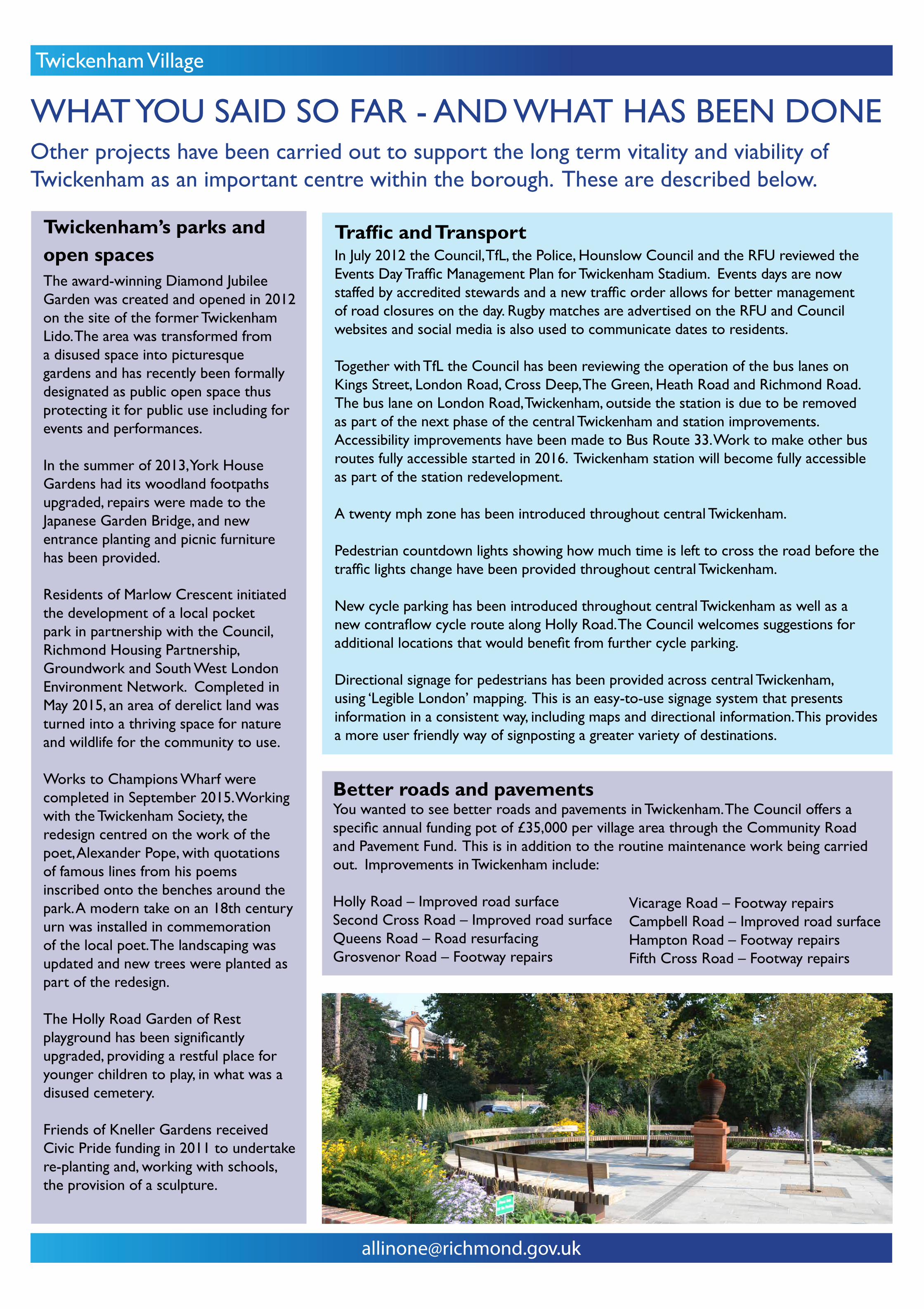
Education facilitiesSt Mary’s Church of England Primary School was expanded from two forms of entry to three in September 2012. St Richard Reynolds Catholic College opened in 2013 at Clifden Road, with a five form entry secondary school and a one form entry primary school. Orleans Primary School has added a new all-through form, and GEMs Twickenham Primary Academy has recently opened. Sixth form colleges opened at Orleans Park School and Waldegrave School in September 2014, accommodating over 200 students.
Work is underway to create an Education and Enterprise Campus on the Richmond upon Thames College site. The Campus will provide a new innovative college of further and higher education working in partnership with Haymarket, Harlequins and their partners, local employers and global companies. The Campus will also provide a new secondary school for 11-16 year olds, with purpose built accommodation for Clarendon School’s secondary pupils and Haymarket’s new ‘tech hub’. Outline planning permission for the Campus was granted in March 2016. The detailed work on the design for each of the constituent parts is now underway.
Sports and Community FacilitiesThe Twickenham Brunswick Club for Young People raised £550,000 for a new boxing facility with funding from the Council, Sport England, the London Marathon Charitable Trust and the London Mayor’s Fund. The new facility opened in 2013, and includes two boxing rings, punch bags, a weight training area and fitness studio. It can now take in more members, has started a girls’ section for the first time and become a regional training centre for English Boxing squads.
In 2015, Heatham House Gym was transformed through internal works and extensions to provide improved spaces and facilities, as well as works to improve the appearance of the building.

Twickenham Village
OPPORTUNITIES TO GET INVOLVED IN YOUR LOCAL AREA
Twickenham SocietyThe Society exists to make Twickenham a better place in which to live. It seeks to stimulate public interest in, and care for, the beauty, history and character of Twickenham and its surroundings. The Society meets at the Twickenham Club, 7 Church Street.
http://www.twicksoc.org.uk/ 020 8977 3516
Friends of Twickenham GreenAn open society of local residents and the wider community working towards the common goal of protecting the charm and integrity of one of South West London’s most-treasured public spaces.
Email: [email protected]://www.twickenhamgreen.org/Pages/default.aspx
HANDSHelp a Neighbour in Distress Scheme (HANDS) is the neighbourhood care group covering Twickenham and St. Margaret’s. They provide voluntary, practical support in non-specialist fields to those in need, especially older, frail, isolated and housebound residents. Support includes driving people to appointments, a Sunday lunch club at St Mary’s Church Hall, shopping for the housebound, and a shopping bus.
Email: [email protected] 020 8891 3346 http://www.handscaregroup.org.uk/about-us
Crane Community CentreThe Community Centre is located at 49 Meadway, Twickenham TW2 6NH. The Centre provides a venue for a wide range of activities, ranging from Irish Dancing to bingo and children’s parties. The building is owned by the Council.
For more information, please see the Council’s website.
Community Connections Richmond (part of Richmond Council for Voluntary Services)Sustainability & Skills Development: Developing the skills base and sustainability of voluntary and community sector, and small businesses with a social purpose.Volunteering Service: Building capacity in voluntary organisations to recruit and retain volunteers and providing a volunteer matching service.
Email: [email protected] Tel: 020 8843 7945Website: http://www.richmondcvs.org.uk/communityconnectionsrichmond
Social MediaTwickenham has its own village Facebook page which is administered by the Council’s Community Links Team:
https://www.facebook.com/groups/TwickenhamVillage/
This is the social media ‘community bulletin board’ for Twickenham where you can find out about local events and anyone in the community can post subjects of interest to the village.
Friends of Kneller GardensThe Friends were formed in 2005. The aim of the group is: to provide a formally recognised group that encourages local people with a genuine interest in Kneller Gardens to participate in the protection, improvement and management of the park, in order to create a safe and enjoyable green open space for use by local residents.
https://en-gb.facebook.com/friendsofknellergardens
York House SocietyThe York House Society is Twickenham’s oldest amenity society. It was formed in 1924 to persuade the then Urban District Council to buy York House for conversion to a town hall. The Society continues to be active in the community, with special interests in central Twickenham, York House and its environs and the neighbouring Thames riverside. The Society meets regularly at York House, and carries on a range of activities throughout the year. Guests are welcome.
http://www.yorkhousesociety.org.uk/

Twickenham Village
MOVING AROUND TWICKENHAMWHAT IS ON OFFER?• The Twickenham village area is served by both Twickenham and Fulwell railway stations.• Main roads include the A316 along the northern edge of the area which provides access to the M3
as does the A305 which also links Twickenham and Richmond. The A310 provides a link north to Brentford and the A4 and M4.
• The area is well served by bus routes which run along both the main roads and some local roads. Staines Road, Hampton Road and Richmond Road have a high number of bus routes running along them. The 281 route provides 24hr connections between Tolworth and Hounslow. The 490 route runs east-west through the area providing a link to Heathrow and Richmond. The 267 provides access to the West Middlesex University Hospital.
• Movement in the area is strongly influenced by the confluence of routes on central Twickenham and there are no crossings over the River Thames in the area although there is a pedestrian and cycle ferry that operates from the river bank at Marble Hill to Ham on the opposite bank.
• An informal off road cycle route exists along the Crane Valley and provides an attractive alternative to the A316 and A305. Road based cycle lanes are also provided along a number of routes into, and through Central Twickenham.
• Paths along the Crane Valley and the Duke of Northumberland River continue to be enhanced and provide an increasingly connected network of walking routes providing links beyond the village area.
What are the opportunities to improve the way in which residents move around the area?Are there particular areas ofpavement, streets or walking routes that need to be enhanced through maintenance, better design, lighting or improved crossing points?What else could be done to encourage walking and cycling?Do cycle routes and cycle parking need to be improved? If so, where?Are there ways in which public transport could be improved?
Village Plan study area
Twickenham Action Area Plan
Rail station
Bus stop
Dedicated cycle route
Main road
Local road
Minor road
London Loop walking route
Key
Staine
s Road
Hampt
on R
oad
Sixth Cross Road
Heath Road
Richmond
Road
A316 Chertsey RoadLo
ndon
Roa
d
A305
Twickenham Village
SHOPS, SCHOOLS, HEALTH AND OTHER FACILITIESWHAT IS ON OFFER?• Central Twickenham offers an important focus for shops and services for residents. In addition,
Twickenham Green and its immediate surrounds is a focus for local shops, restaurants and community buildings. There are a number of local parades including on Staines Road and Richmond Road. Out-of-town style retail units are found at the junction between Sixth Cross Road and Hampton Road, as well as at the Hampton Road roundabout with the A316.
• The area is well-served by primary and secondary schools including: Orleans Park, Richmond-upon-Thames College, Waldegrave School, The Mall School, St Richard Reynolds Catholic College, Trafalgar Infant and Junior Schools, Orleans Primary School, St Mary’s Church of England Primary School and GEMS Twickenham Primary Academy.
• Healthcare facilities within the area are focused on local doctor and dentist surgeries. The nearest walk-in NHS health centre and hospital is to the south of the area in Teddington.
• In addition to Twickenham’s nationally important rugby venue at Twickenham Stadium and The Stoop, the area benefits from a number of training grounds and recreation areas for local use including Craneford Way Recreation Ground, Kneller Gardens and Fulwell Public Golf Course.
• Churches include the United Reformed Church, Twickenham Green Baptist Church, Holy Trinity Church, All Saints Church, All Hallows Church, St. Mary’s Church and Twickenham Methodist Church.
• Cultural and community facilities include the Twickenham Museum, The Mary Wallace Theatre, the World Rugby Museum, Orleans House and its Gallery and Marble Hill House, the Crane Community Centre and a new Community and Cultural space at Brewery Wharf.
What are your views on facilities and shopping in the Twickenham area?Do shop frontages need to be improved?Are there areas of empty shops that are no longer needed, or areas where more shops are required?Is there a need to improve community facilities including health, or provide more leisure, arts and cultural facilities?
Village Plan study area
Twickenham Action Area Plan
Local shops, facilities, restaurants, bars and cafes
Community, leisure, culture and tourism
Education
Employment
Healthcare
Key
Staine
s Road
Hampt
on R
oad
Sixth Cross Road
Heath Road
Richmond
Road
A316 Chertsey RoadLo
ndon
Roa
d
straight across line boundary
Take Strawberry Hill boundary out
Twickenham Village
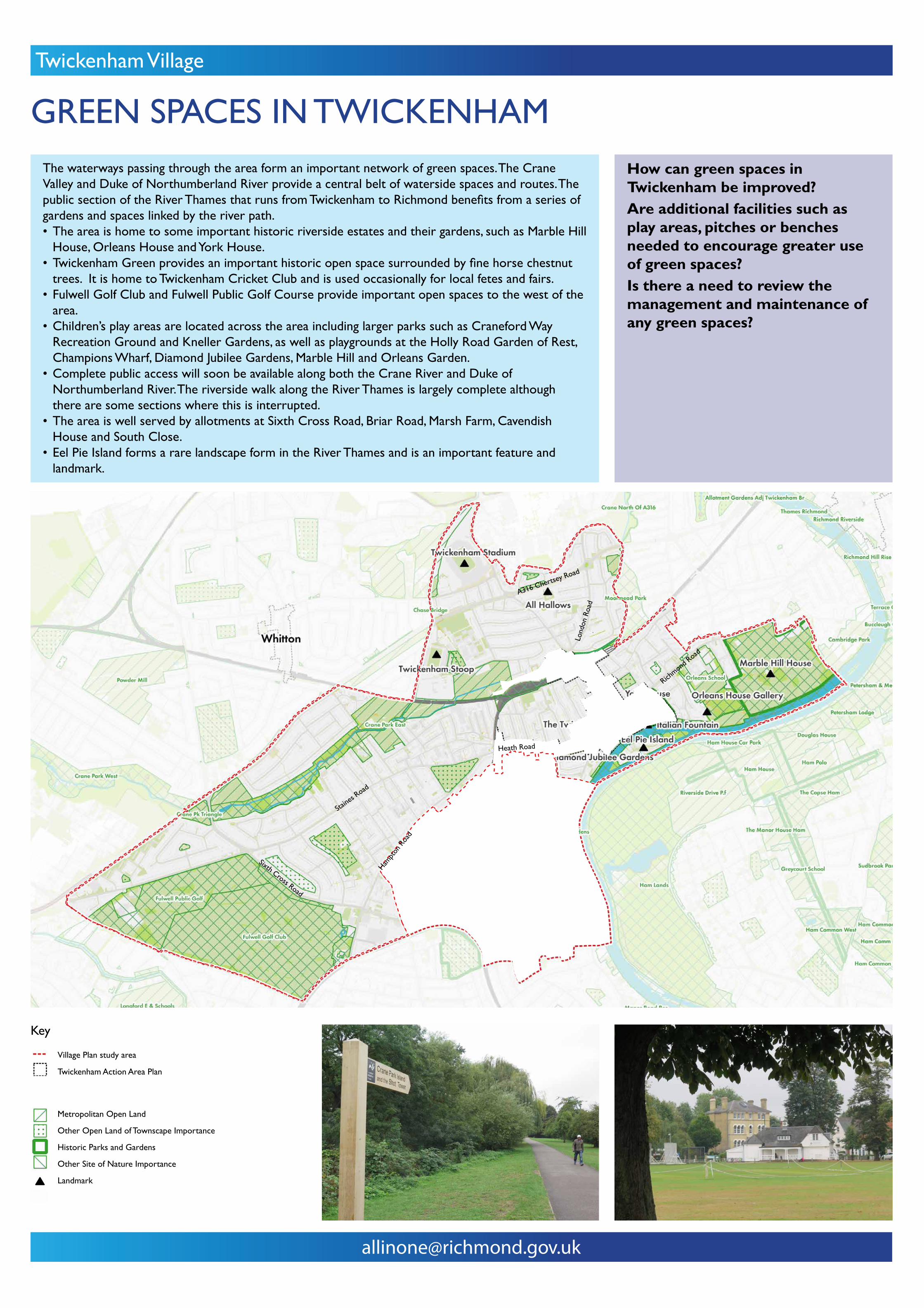
GREEN SPACES IN TWICKENHAMThe waterways passing through the area form an important network of green spaces. The Crane Valley and Duke of Northumberland River provide a central belt of waterside spaces and routes. The public section of the River Thames that runs from Twickenham to Richmond benefits from a series of gardens and spaces linked by the river path.• The area is home to some important historic riverside estates and their gardens, such as Marble Hill
House, Orleans House and York House.• Twickenham Green provides an important historic open space surrounded by fine horse chestnut
trees. It is home to Twickenham Cricket Club and is used occasionally for local fetes and fairs.• Fulwell Golf Club and Fulwell Public Golf Course provide important open spaces to the west of the
area.• Children’s play areas are located across the area including larger parks such as Craneford Way
Recreation Ground and Kneller Gardens, as well as playgrounds at the Holly Road Garden of Rest, Champions Wharf, Diamond Jubilee Gardens, Marble Hill and Orleans Garden.
• Complete public access will soon be available along both the Crane River and Duke of Northumberland River. The riverside walk along the River Thames is largely complete although there are some sections where this is interrupted.
• The area is well served by allotments at Sixth Cross Road, Briar Road, Marsh Farm, Cavendish House and South Close.
• Eel Pie Island forms a rare landscape form in the River Thames and is an important feature and landmark.
How can green spaces in Twickenham be improved?Are additional facilities such as play areas, pitches or benches needed to encourage greater use of green spaces?Is there a need to review the management and maintenance of any green spaces?
Village Plan study area
Twickenham Action Area Plan
Metropolitan Open Land
Other Open Land of Townscape Importance
Historic Parks and Gardens
Other Site of Nature Importance
Landmark
Key
Staine
s Road
Hampt
on R
oad
Sixth Cross Road
Heath Road
Richmond
Road
A316 Chertsey RoadLo
ndon
Roa
d

Twickenham Village
INTRODUCTION TO VILLAGE PLANNING GUIDANCEThe Council wants residents and businesses to help prepare ‘Village Planning Guidance’ for the Twickenham Village area. This will be a document that the Council considers when deciding on planning applications. Village Planning Guidance can:
• Help to identify what the ‘local character’ of your area is and what features need to be retained.
• Help maintain and enhance the local character of your area, particularly if it is not a designated ‘Conservation Area’.
• Establish key design principles that new development should respond to.
The boundary has been based on the Village Plan area to reflect the views of where people live, as well as practical considerations to support the local interpretation of planning policy including how the boundaries of Conservation Areas are defined. In the case of the Twickenham Village Planning Guidance, the area includes St. Catherine’s School and Cross Deep, including Radnor Gardens, because they fall within the Twickenham Riverside Conservation Area.
Since 2010 Richmond Council has carried out a number of wide-spread consultations regarding the future of Twickenham Town Centre and the Riverside. This includes the Barefoot Consultation, Twickenham Conference and the All in One survey. As a result, the Twickenham Area Action Plan (APP) was developed.
The AAP provides a framework for development and change in the town centre over the next 15 years. It sets out proposals for several key sites in the town and outlines proposals for improving the public realm and the riverside. It was adopted in July 2013 following extensive public consultation and external scrutiny. The AAP is part of the statutory development plan for the borough and is a key consideration during the planning process. The AAP includes the area covered by the ‘Twickenham Rediscovered’ project.
To ensure that there is no confusion during the planning process, the future Village Planning Guidance SPD for Twickenham will not cover the geographical area that is already covered by the Area Action Plan. However, the wider Village Plan for Twickenham includes central Twickenham and the riverside, and residents and businesses within the AAP area are encouraged to take part in the wider Village Plan work.
How can I get involved?There will be two different stages of engagement and consultation before the guidance is adopted.
During February and March 2017 residents and businesses are being asked about their vision for the future of their areas, thinking about:
• the local character• heritage assets• improvement opportunities for specific
sites or areas• other planning policy or general village
plan issues
Draft guidance will then be developed based on your views and a formal (statutory) consultation will be carried out in Summer/Autumn 2017 before the guidance is adopted.
How does Village Planning Guidance work?The Village Planning Guidance will become a formal planning policy ‘Supplementary Planning Document’ (SPD) which the Council will take account of when deciding on planning applications, so it will influence developers and householders in preparing plans and designs. This includes any aspect of changing the physical environment that requires a planning application for built development and other matters such as new street signs, shop fronts, road layouts or cycleways.
How does the ‘Village Planning Guidance’ relate to Village Plans?The Planning Guidance builds on the ‘Village Plans’ which were developed from the 2010 ‘All in One’ survey results, and from on-going consultation, including through the engagement events currently underway and later in the year. The Village Planning Guidance will be a dedicated section as part of the Village Plans.
RR
Staines Road
Hampt
on R
oad
Heath Road
Richmond
Road
A316 Chertsey Road
Aerial Photograph showing the Village Planning Guidance area
Twickenham Village
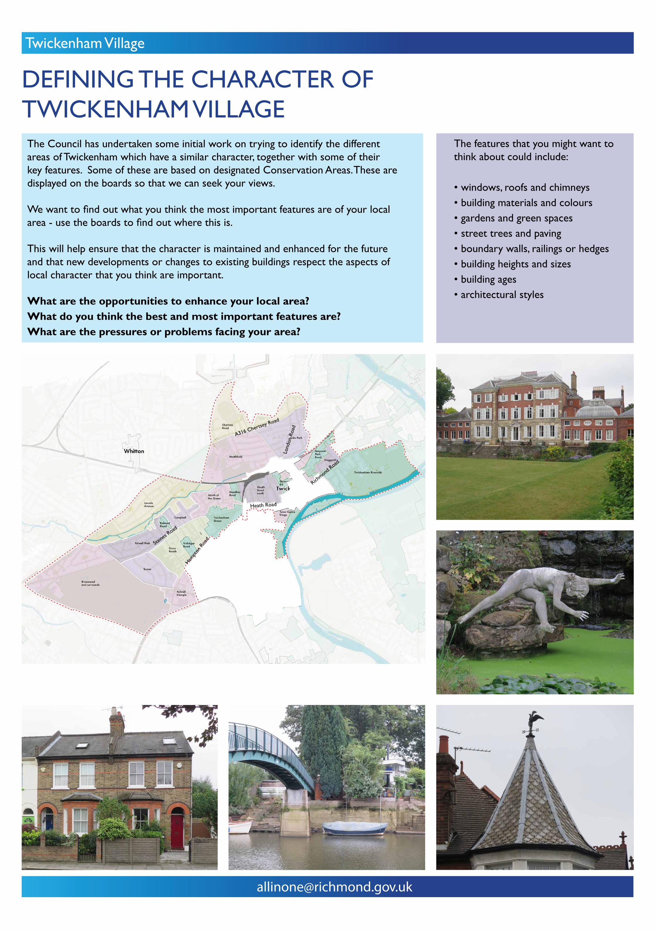
DEFINING THE CHARACTER OF TWICKENHAM VILLAGEThe Council has undertaken some initial work on trying to identify the different areas of Twickenham which have a similar character, together with some of their key features. Some of these are based on designated Conservation Areas. These are displayed on the boards so that we can seek your views.
We want to find out what you think the most important features are of your local area - use the boards to find out where this is.
This will help ensure that the character is maintained and enhanced for the future and that new developments or changes to existing buildings respect the aspects of local character that you think are important.
What are the opportunities to enhance your local area?What do you think the best and most important features are?What are the pressures or problems facing your area?
The features that you might want to think about could include:
• windows, roofs and chimneys• building materials and colours• gardens and green spaces• street trees and paving• boundary walls, railings or hedges• building heights and sizes• building ages• architectural styles
Staine
s Road
Hampt
on R
oad
Heath Road
Richmond
Road
A316 Chertsey Road
Lond
on R
oad

Twickenham Village
THE CHARACTER OF TWICKENHAM VILLAGE
Character Area 4: Turner• This character area consists of a series of
curving parallel avenues connecting Staines Road (A305) with Sixth Cross Road.
• The residential area was laid out in the 1930s and influenced by the Garden City style, with a consistent character of semi-detached and terraced housing in stucco and red brick.
• Housing along Sixth Cross Road dates from the 1930s and is predominantly semi-detached houses set back behind deep front gardens. Large mature street trees help frame the road, supported by a deep green verge to the south.
• Dominant materials and features include half rendered red brick and stucco houses, pastel colouring, prominent chimneys, hipped and gabled roofs, clay Roman tiles and tudorbethan features.
Character Area 5: Fulwell Triangle• This character area is located at the southern
edge of the study area, bounded by the rail line and Stanley Road to the east.
• The area has a varied character with a mix of commercial and industrial units to the south, characterised by large footprint buildings from retail sheds to a bus depot, set within areas of outdoor storage, servicing and parking.
• Small and enclosed residential areas are located to the north, including Grove Road, Queen Anne’s Close and Wellington Gardens.
• Dominant materials and features include red brick, gables, tile hung, prominent chimneys.
Staines Road
Character Area 1: Rivermead and surrounds• The character area is on the western edge
of the study area and includes the Rivermead Estate, Fulwell Golf Course and Twickenham Road to the west.
• The inter-war Rivermead Estate has a distinctive triangular residential form arranged as an outer and inner cul-de-sac, built in the Garden City style. It has a consistent character of pre-dominantly semi-detached houses.
• There is a varied character to the west of Rivermead, including a mix of commercial and residential areas.
• Along Twickenham Road inter-war detached and semi-detached properties front the street. To the north, the relationship between buildings and the streets changes with mid-century blocks of housing set well back from or perpendicular to the street.
• Fulwell Golf Course is largely hidden by railings, large trees and shrubbery on Staines Road and Sixth Cross Road.
• Dominant materials and features include red brick, white render, terracotta tiling, yellow brick terraces, front gardens, street trees.
Character Area 3: Fulwell Park • This character area is located in the western
half of the study area and is characterised by short residential terraces to the south of the River Crane. It includes the shops and housing along Staines Road and Manor Road.
• The area is characterised by inter-war Garden City style housing, laid out on the former Fulwell estate. Semi-detached inter-war housing also fronts Staines Road.
• Houses along the northside of Staines Road are distinguished from those on the southside, with more prominent tudorbethan features and elongated timber and tile door canopies.
• Dominant materials and features include red brick, roughcast finish, picket fencing, small front gardens, hipped roofs and bay windows.
Character Area 2: Lincoln Avenue• This area includes the extent of Crane Park
that is within the Twickenham Village boundary, and the housing to the north, enclosed by Chertsey Road and the railway line to the east.
• The residential area benefits from its proximity to Crane Park, but is relatively isolated from other housing. The inter-war housing area is characterised by short blocks of terraces.
• This section of Crane Park follows the bend of the River Crane, with woodland, scrub and reedbed at the riverside and shared use footpaths running alongside. There are points at which the park opens up with large expanses of green space.
• Dominant materials and features include gabled roofing, tile hung, timber cladding, red brick.

Twickenham Village
Conservation Area 8: Belmont Road• This conservation area is located between
Staines Road and Crane Park, and accessed from Staines Road.
• It is a residential development of villas built in the mid 19th Century on open fields.
• The villas are in two and three storey pairs, in the Italianate style.
• Dominant materials and features include stucco façades, shallow slate roofs, classic details with moulded window surrounds, rusticated plinths, quoins and porches, large and mature garden plots and consistent rendered boundary walls.
Character Area 6: Cross Roads• The Cross Roads character area are a series
of parallel roads connecting Staines Road with Hampton Road.
• The 1818 Enclosure Award led to the development of the roads which were laid out by 1865, bar Gothic Road and Elmsleigh Road which were built later in the early 1900s.
• The area is mainly residential housing belonging to a wide variety of ages and styles, ranging from Victorian terraces along Denmark Road, which front directly onto the street, to post-war housing on Third Cross Road with small front gardens and brick walls.
• Dominant materials and features include red and yellow brick, stucco and front gardens.
Conservation Area 7: Trafalgar Road• This conservation area is a tranquil residential
area bounded by Hampton Road to the south east, Fourth Cross Road to the south west and Gothic Road to the north west.
• Villa style houses of the mid 19th Century, distinctive for their consistent scale and style of architecture.
• Dominant materials and features include painted stucco or stock brick walls, moulded architraves or consoles above the windows, attractive iron balconies, canopies and porches, low pitched slate roofs, and mature trees, hedges and shrubberies in large front gardens.
Conservation Area 9: Twickenham Green • This conservation area is focused on
Twickenham Green at the meeting point between Staines Road and Hampton Road, with its distinctive triangular shape.
• A historic open green, most development around it is from the 19th Century, but some 18th Century elements have survived.
• The conservation area is a mix of residential, commercial, community and industrial uses. Three churches front onto the Green.
• Dominant features and materials include brick, slate roofs, mature trees.
Staines Road
Character Area 10: Campbell• The character area is located to the north
of Staines Road and encompasses Campbell Close, Churchview Road, Brinsworth Close and Meadway, a long north-south avenue crossing the Crane Valley.
• The area is residential with a variety of types, materials and ages of housing. All of the housing addresses the streets with varying depths of front gardens.
• Terraced houses along Campbell Road date from the late 19th Century and are characterised by red and yellow brick exteriors and attractive front gardens.
• Brinsworth Close, built in the 1950s, is a small cul-de-sac of terraces behind wide grass verges.
• Meadway is characterised by inter-war semi-detached housing or small blocks of terraces with a mix of gabled bays and hipped roofs with picket fencing in front.
• Campbell Close is an early development by the pioneering Span Development Ltd built c.1955.
• Churchview Road is dominated by three-storey blocks of flats and All Saints Church.
• Dominant features and materials include red and yellow brick, street trees, and red roof tiles and protruding chimneys along Meadway.

Twickenham Village
Character Area 11: North of the Green• This character area takes in the residential area
to the north of Twickenham Green, up to the River Crane.
• The area was one of the first areas to be rapidly developed in the late 1880s, along Colne Road, Mereway Road, Albion Road and May Road.
• The area is largely characterised by late Victorian terraced housing, generally in London stock brick and slate roofs.
• The area is also distinguished for its light industry tucked between the Green and the River Crane.
• Dominant materials and features include red brick surrounds, small front gardens, prominent chimneys and sash windows.
Conservation Area 12: Hamilton Road• This conservation area is a Victorian area
to the north of Staines Road, encompassing Hamilton Road, Warwick Road and parts of Edwin Road.
• Distinctive townscape of late Victorian and Edwardian industrial buildings and housing.
• The uniform terraced houses accommodated workers at the nearby Hamilton Electricity Works - Twickenham’s first – and were supplied with power from it.
• The former Hamilton electricity works is an important local landmark and the focus of the view along Hamilton Road.
• Dominant materials and features include London stock brick with red brick dressings, distinctive round arched porch recesses and pitched slate roofs with brick chimneys.
Conservation Area 15: Queens Road• This conservation area is west of London
Road between King Street and the railway line. It is focused on Queens Road, with part of Grosvenor Road and Holly Road.
• This is an area of Victorian and Edwardian semi-detached houses with some pockets of small Victorian cottages, and a collection of large Victorian buildings along the eastern edge of the area with dominant character.
• Dominant materials and features include London stock brick and red brick dressings and bay windows.
Character Area 13: Heath Road north• This character area is found on the north side
of Heath Road and stretches up to the rail line to the north. It includes Talbot Road and Marsh Farm to the west of the railway.
• Primarily a residential area dating from the early Victorian era with tight streets of small terraced housing against the rail line, and late Victorian and Edwardian terraces and villas to the east.
• To the north east of the area, larger footprint and denser housing is found developed in the inter-war period. St. Richard Reynolds Catholic College is the principal landmark.
• Dominant materials and features include London stock brick with red dressings, red brick, stucco, slate and tile roofs. Mature street trees including limes and chestnuts line the roads.
Character Area 14: Town Centre fringe• This character area is comprised of the sub-
areas of Poulett Gardens, Station Yard, Arragon Road and Mary’s Terrace, all of which are located on the periphery of the town centre.
• Poulett Gardens to the south of Heath Road is distinct for its consistent character of inter-war semi-detached housing.
• The other sub-areas are defined by their fragmented and varying character with lower-rise residential properties tucked behind multi-storey blocks fronting London Road.
• Arragon Road is comprised of large Victorian townhouses. Low-rise late Victorian terraced housing fronts the narrow Mary’s Terrace in a dramatic contrast to the height and block of the neighbouring Regal House.
• Dominant materials and features include stock brick, render and slate roofs.

Twickenham Village
Conservation Area 19: Amyand Park Road• This conservation area is to the south of the
railway line and north of Richmond Road, to the north east of central Twickenham.
• This is an area of late Victorian and Edwardian terraces and semi detached cottages, and larger three storey buildings to the south west.
• The 18th century listed St. John’s Hospital is an important local landmark alongside Amyand House and Oak Lane Cemetery.
• Oak Lane Cemetery has a high brick wall, iron gates and gate piers which provide an enclosed green space adjacent to Devoncroft Gardens.
• The curve of Amyand Park follows the railway line and offers a changing view.
• Dominant materials and features include front garden planting, large trees, strong boundaries, brick façades, decorative moulded windows and door surrounds.
Staines Road
Character Area 17: Chertsey Road• This character area is dominated by
Twickenham Stadium, located centrally and bound by the Duke of Northumberland River to the west, Whitton Road to the south and Rugby Road to the east.
• The stadium is a world famous landmark with a capacity of 82,000 spectators.
• The area is characterised by the dramatic contrast in scale, from the giant stadium to the modest semi detached inter-war housing along Whitton Road and Chertsey Road.
• Dominant features and materials include red tiled hipped and gabled roofs, tudorbethan features, red brick and white render.
Character Area 16: Heathfield• This character area is located south of
Chertsey Road, west of Whitton Road and to the north of the River Crane.
• Heathfield North and South were the earliest roads built and later extended in the 1930s alongside development of a series of parallel roads, resulting in a predominantly inter-war housing style of semi-detached properties.
• Richmond College was built in the 1930s and has imposing art-deco influences.
• The Stoop Memorial Ground is a local landmark set back from Chertsey Road with car-parking in front, and to the south-west is Twickenham Central Depot.
• Dominant features and materials include red brick and white render, tudorbethan features, hard concrete surfaces, green verges.
Character Area 20: Haggard• This character area is located to the north
of Richmond Road, south of Amyand Park Road and west of Marble Hill Gardens.
• The area is focused on Haggard Road, with rows of late Victorian terraced housing to the west and three-storey townhouses to the east, culminating in a 1960s estate of four blocks of flats set amongst open green space.
• Orleans Court is another block of 1960s housing located at Seymour Gardens, contrasting with a single storey Scout Hut and a small terrace of quaint Edwardian houses with colourful planting and white painted front balconies.
• Dominant materials and features include London stock brick and slate roofs, sash windows with decorative white surrounds.
Character Area 18: Cole Park• This character area is located to the east of
Whitton Road, south of Chertsey Road and to the west and north of the River Crane.
• The area is characterised by detached Edwardian houses to the east of London Road and Edwardian terraces to the south.
• This contrasts with later development to the west, including 1930s semi-detached housing with art-deco features and 1960s bungalows.
• Cole Park Road has a distinctly different feel characterised by large houses laid out along a wide avenue framed by large mature trees.
• Dominant materials and features include red brick and white render, decorative porches, tudorbethan features, large mature trees, gabled bay windows, front gardens.

Twickenham Village
Conservation Area 21: Twickenham Riverside• This conservation area stretches from Marble
Hill Park along the riverside to Radnor Gardens. It also includes Eel Pie Island.
• The area is greatly characterised by its historic and architectural value as the original village core and river frontage, evidenced by the great number of listed buildings within the area, including the 17th century York House and St. Mary’s Church, which remains an important focal point.
• Many of these 17th and 18th century grand buildings are set within extensive landscaped gardens and public open spaces.
• The curves of the river have helped shape its landscape and townscape, giving unfolding views of both banks framed by mature trees and foliage.
• The area is characterised mainly by narrow streets and alleyways with 18th Century two and three storey buildings.
• Radnor Gardens to the west is an individual area of public open space by the Thames.
• Richmond Road has a varied character ranging from 1930s mansion blocks to Victorian terraced cottages.
• Lebanon Park is a very distinctive area of Edwardian houses built on the grounds and site of a large villa, Mount Lebanon, which burned down in 1909.
• Eel Pie Island has its own unique character and is a landmark in the Thames landscape.
• Key materials and features include spacious gardens, narrow streets, mature trees.