Embed Size (px)
Citation preview

3 KEY FINDINGSSECTION PAGE SECTION PAGE
3.1 Introduction 3.2
3.1.1 Specialist investigations 3.2
3.1.2 The structure of this chapter 3.3
3.2 Key assets, values and uses 3.3
3.3 Potential impacts toregional groundwater 3.4
3.5 Acid sulfate soils and contamination 3.14
3.5.1 Excavation techniques 3.14
3.5.2 Acid sulfate soils 3.14
3.5.3 Contamination 3.17
3.5.4 Meeting the evaluation objective 3.18
3.6 Informing the EnvironmentalManagement Framework 3.193.3.1 Edithvale 3.7
3.3.2 Bonbeach 3.9 3.7 Summary of key findings 3.20
3.3.3 Meeting the evaluation objectives
3.10
3.4 Edithvale-Seaford Wetlands and groundwater dependent ecosystems
3.10
3.4.1 Edithvale-Seaford Wetlands 3.113.4.2 Groundwater dependent
ecosystems3.13
3.4.3 Native vegetation 3.13

3.2 Edithvale and Bonbeach Environment Effects Statement |
3.1 IntroductionThis chapter provides an overview of the key findings of the EES.
The primary focus of the EES is to assess the potential for the projects to impact regional groundwater movements, and the effect this could have on the internationally-important Edithvale-Seaford Wetlands. It also assess how the trenches could expose existing contamination and potential acid sulfate soils, and possibly affect human health, recreation and ecosystems.
This chapter also includes references to the Environmental Performance Requirements (EPRs) relevantto each key finding. As set out in Chapter 1 Introduction, the EPRs define the environmental outcomes that must be achieved during design, construction and operation of the Edithvale and Bonbeach level crossing removal projects, regardless of the detailed design solutions adopted. They may also represent the measures developed in this EES to avoid, reduce or manage potential environmental impacts so that the key findings presented here are a realistic reflection of the likely environmental performance of the projects. The full list of EPRs is provided in Chapter 9 Environmental Management Framework.
3.1.1 Specialist investigationsFourteen specialist investigations have been undertaken to identify and assess the potential environmental effects associated with realising the critical benefits of the projects. Three of these studies focus on issues which were identified by preliminary investigations and subsequently considered by the Minister for Planning to be potentially significant enough to require an EES:
• potential short and long-term effects on the regional groundwater regime• potential short and long-term effects on the ecological character of the Edithvale-Seaford Wetlands and
groundwater dependent ecosystems
• potential activation of coastal acid sulfate soils and subsequent groundwater use.
The remaining 11 investigations focus on issues that are common to all construction projects. These issues need to be understood in a local context to ensure that the management of these potential effects is appropriate for thesite conditions and local community. All 14 investigations focus on the potential effects of the proposed rail trenches described in Chapter 2 Rationale and project descriptions.
The specialist investigations are included as appendices to this EES.

Edithvale and Bonbeach Environment Effects Statement | Key findings 3.3
3.1.2 The structure of this chapterIn this chapter:• Section 3.2 presents a summary of the key assets, values and uses within the Edithvale and Bonbeach areas.• Section 3.3 summarises the key findings of Chapter 5 Modelling the water environment, as understanding the
potential changes to the groundwater regime is key to identifying and assessing the potential impacts to the other matters identified by the Minister for Planning in the Scoping Requirements for the EES.
• Section 3.4 summarises the key findings of Chapter 6 Edithvale-Seaford Wetlands and groundwater dependent ecosystems.
• Section 3.5 summarises the key findings of Chapter 7 Acid sulfate soils and contamination.• Section 3.6 summarises the key findings of Chapter 8 Potential local impacts at Edithvale and Bonbeach.• Section 3.7 summarises the key findings in the context of the EES Scoping Requirements and draft
evaluation objectives.
Sections 3.3, 3.4 and 3.5 also outline how the EES responds to the draft evaluation objectives set out in the Scoping Requirements for the EES.
3.2 Key assets, values and usesThe Edithvale and Bonbeach areas are primarily residential, with increasing population densities and a population that is getting younger – attracted to the area in part due to the recreational lifestyle it caters for and, most notably, the Port Phillip Bay foreshore.
Inland, both the Edithvale-Seaford Wetlands and the Wannarkladdin Wetlands provide key environmental and social values for the area. The ecological value of the Edithvale-Seaford Wetlands is internationally recognised for providing a habitat for migratory species, while the Wannarkladdin Wetlands are more accessible for the public.
The Edithvale and Bonbeach areas contain a high number of both active and passive recreation reserves, including:
• the foreshore• golf courses• Edithvale Recreation Reserve• Bicentennial Park• Bonbeach Sports Reserve• Patterson River.
The open spaces provide recreation opportunities for local residents and residents of the surrounding areas, and include sports fields, playgrounds, and cycling and walking trails. A number of recreational facilities and residences in the area have registered groundwater bores typically used for irrigation and domestic purposes. The Edithvale and Bonbeach areas also contain a number of schools and aged care facilities. Surf Life Saving Clubs at both Edithvale and Bonbeach are important community assets.
The area is served by the Frankston rail corridor, with stations at Edithvale and Bonbeach. The road network predominantly comprises local streets serving residential areas. However, both the Nepean Highwayand Edithvale Road serve important regional arterial functions. Edithvale Road connects the area to the Mornington Peninsula Freeway (M11) and to Melbourne’s eastern suburbs via Springvale Road, Eastlink and Westall Road. Both railway stations are adjacent to commercial precincts on the western side of Nepean Highway, which are largely dependent on the residents who live east of, and whose access to the shops is restricted by, the highway and rail corridor.
3.4 Edithvale and Bonbeach Environment Effects Statement |
3.3 Potential impacts to regional groundwater
The proposed rail trenches would extend into the groundwater below the surface. The piled walls of the trenches described in Chapter 2 Rationale and project descriptions would create an obstruction to the flow of groundwater, which flows in a westerly direction towards the coast at Edithvale and in a more south-westerly direction towards the coast and Patterson River at Bonbeach.
The obstruction created by the walls of the trench would require groundwater to travel around the trench, which would have an effect similar to a dam in a river, with groundwater mounding up-gradient (that is, rising water table ‘upstream’) and groundwater drawdown down-gradient (lowering of the water table ‘downstream’) of the trenches.
The depth to the water table across the region currently varies greatly, depending on the elevation of the ground surface, the time of year, and longer term climatic trends. For example, the water table is deeper during summer months, and extended dry periods such as droughts.
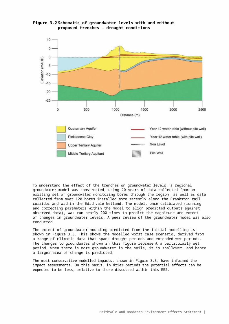
The natural variability, and the mounding and drawdown effects for an extended wet period when the groundwater is shallower and closer to the surface are shown conceptually in Figure 3.1. Figure 3.2 depict drought conditions when the water table is deeper.
Figure 3.1 Schematic of groundwater level with and without proposed trenches – extended wet period

Edithvale and Bonbeach Environment Effects Statement | Key findings 3.5
Figure 3.2 Schematic of groundwater levels with and without proposed trenches – drought conditions
To understand the effect of the trenches on groundwater levels, a regional groundwater model was constructed, using 20 years of data collected from an existing set of groundwater monitoring bores through the region, as well as data collected from over 120 bores installed more recently along the Frankston rail corridor and within the Edithvale Wetland. The model, once calibrated (running and correcting parameters within the model to align predicted outputs against observed data), was run nearly 200 times to predict the magnitude and extentof changes in groundwater levels. A peer review of the groundwater model was also conducted.
The extent of groundwater mounding predicted from the initial modelling is shown in Figure 3.3. This shows the modelled worst case scenario, derived from a range of climatic data that spans drought periods and extended wet periods. The changes to groundwater shown in this figure represent a particularly wet period, when there is more groundwater in the soils, it is shallower, and hence a larger area of change is predicted.
The most conservative modelled impacts, shown in Figure 3.3, have informed the impact assessments. On this basis, in drier periods the potential effects can be expected to be less, relative to those discussed within this EES.
3.6 Edithvale and Bonbeach Environment Effects Statement |
Figure 3.3 Potential water logging at Edithvale and Bonbeach predicted by the initial modelling
3.3.1 EdithvaleAn initial assessment was undertaken which included modelling of project operation based on the pile wall configuration described in Chapter 2 Rationale and project descriptions. The groundwater model prepared for the EES predicted that the trench proposed at Edithvale would result in groundwater mounding on the inland side that could potentially increase the frequency of water logging that already occurs on occasion in the Edithvale area, as shown in Figure 3.3.
This is because of the naturally very shallow water table and because groundwater flows at right angles to the proposed trench towards the coast. This direction of groundwater flow means that the damming effect of the trench is at its most significant. If the groundwater flow was less perpendicular to the trench, the mounding effect would be less because the trench would present less of an obstacle to groundwater flow.
In response to the risk of water logging, and other potential issues including activation of acidsulfate soils and a potential increase in the salinity of groundwater, a mitigated assessment was undertaken. This involved amending the project design to include an engineering solution thatwould enable groundwater to flow around the trench and reduce the potential mounding to within natural variability. The engineering solution was then tested using the groundwater model to confirm it would be effective to reduce groundwater mounding so thatit would not result in additional water logging.
Based on the mitigated assessment, the predicted groundwater level changes were less, compared with the initial assessment at Edithvale. The model predicts that with the engineering solution to manage groundwater flows in place, levelsmay rise up to 0.2 metres within 50 metres of the trench walls on the up-gradient or inland side, with levels reducing on the down-gradient (coastal) side by 0.3 metres within 50 metres of the trench. Contours representing the extent of mounding and drawdown after the engineering solution has been implemented are shown in Figure 3.4.

3.8 Edithvale and Bonbeach Environment Effects Statement |
Figure 3.4 Modelled changes to groundwater levels at Edithvale based on the mitigated assessment

Edithvale and Bonbeach Environment Effects Statement | Key findings 3.9
The groundwater changes based on the implementation of the engineering solution are within the range of natural variability and would not affect existing water logging.
Based on the mitigated assessment, the key findings of the model also indicate that:• Mounding is predicted to reduce to less than 0.1 metres within 150 metres of the trench, and therefore would
return to background levels at around 1,000 metres of the Edithvale-Seaford Wetlands. On this basis, the assessment presented in Chapter 6 Edithvale-Seaford Wetlands and groundwater dependent ecosystems and Technical Report B Ecology: Wetlands and Groundwater Dependent Ecosystems concludes that it would be almost impossible for the proposed rail trenches to affect regional groundwater to the extent that the ecological character of the Edithvale-Seaford Wetlands would be affected.
• Drawdown on the coastal side of the trench is predicted to reduce to less than 0.1 metres also within 150 metres of the trench. On this basis, the risk to beneficial uses of groundwater, including groundwater bore users and vegetation, is considered to be negligible.
3.3.2 BonbeachThe initial assessment included groundwater modelling at Bonbeach, based on the piled walls of the trench described in Chapter 2 Rationale and project descriptions.
Groundwater is naturally deeper at Bonbeach than it is at Edithvale, resulting in lower potential for interference from the trench. The direction of groundwater flow is also different at Bonbeach, flowing in a south-westerly direction, meaning that the north-south oriented trench presents less of an obstacle to groundwater flow, and subsequently results in less mounding than if the trench was at right angles to groundwater flow asat Edithvale.
The groundwater mounding and drawdown predicted through the initial assessment at Bonbeach was significantly less in terms of magnitude and extent of potential impacts, when compared to the initial modelling predictions for Edithvale. Contours representing the extent of mounding and drawdown are shown in Figure 3.3. This demonstrates that the project would not result in any water logging of the Bonbeach area.
The construction of the proposed trench at Bonbeach is predicted to result in groundwater mounding on the inland side of the trench and drawdown on the coastal side of the trench. Groundwater mounding of up to 0.4 metres within 50 metres of the rail trench is predicted, along with groundwater drawdown of up to0.7 metres within 50 metres of the rail trench. The mounding would not result in water logging and would not have any significant impact. Minor implications associated with drawdown are as follows:
• potential activation of small, localised areas of acid sulfate soils (discussed in Section 3.5, and Chapter 7Acid sulfate soils and contamination)
• reduced availability of water for a small number of domestic groundwater users who have groundwater bores installed between the rail corridor and Port Phillip Bay.
A mitigated assessment was not undertaken for Bonbeach, since the risks identified through the initial assessment were considered sufficiently low, such that further mitigation beyond the modelled project design would not be required. The pile wall configuration proposed includes measures that minimise potential impacts to groundwater, including stepped depths of impermeable piles. The design of the Bonbeach project would still be required to meet the requirements of the EPRs. Refer to Chapter 2 Rationale and project descriptions for further information.

EES evaluation objectiveTo prevent effects on the regional groundwater regime and quality, particularly as they might impact on the hydrology of the Edithvale-Seaford Wetlands and elsewhere on other beneficial uses.
3.10 Edithvale and Bonbeach Environment Effects Statement
3.3.3 Meeting the evaluation objectivesThe impact assessment focused on project-induced groundwater level impacts resulting from groundwater level drawdown and mounding as a result of the projects. The potential impacts associated with this change that were considered were:
• short-term construction impacts• interference with local groundwater users• interaction with existing contaminated or potentially contaminated groundwater• changes to groundwater levels in the vicinity of groundwater dependent ecosystems
(particularly the Edithvale-Seaford Wetlands)• potential for water logging• potential for subsidence impacts• potential for acid sulfate soil activation• potential for saline intrusion.
Overall, the projects would meet the evaluation objective to minimise effects on the regional groundwater regime. The design assessed within this EES minimises potential effects on regional groundwater and associated beneficial uses, and critically, does not result in changes to the hydrology at the Edithvale-Seaford Wetlands.
3.4 Edithvale-Seaford Wetlands and groundwater dependent ecosystems
The Edithvale-Seaford Wetlands, including its native vegetation, habitat and wetland species, would not be impacted by the proposed projects.
The wetlands are listed under the Ramsar Convention on Wetlands of International Importance, recognised globally for their important habitat for migratory species. They are protected by the Commonwealth Environment Protection and Biodiversity Conservation Act 1999 (the EPBC Act), and are one of a number of Groundwater Dependent Ecosystems (GDEs) in the region which have been considered in this assessment.
For a wetland to be listed under the Ramsar Convention, it must satisfy one or more of the criteria for identifying wetlands of international importance. The assessment has considered the capacity of the Edithvale-Seaford Wetlands to continue to meet the Ramsar listing criteria.
A GDE is defined as:
‘those ecosystems that require access to groundwater to meet all or some of their water requirements so as to maintain the communities of plants and animals and ecological processes they support, and ecosystem services they provide’.
A conceptual diagram showing the relationship between GDEs and the water cycle is shown in Figure 3.5.

Edithvale and Bonbeach Environment Effects Statement | Key findings 3.11
Figure 3.5 Groundwater dependent ecosystems
The Edithvale-Seaford Wetlands are regarded as a GDE as they are considered to rely, at least in part, on groundwater to sustain its flora, fauna and overall ecological character. A summary of the assessment undertaken into the Edithvale-Seaford Wetlands, and a discussion of other potentially affected GDEs throughout the area, are presented below.
3.4.1 Edithvale-Seaford WetlandsThe Edithvale-Seaford Wetlands represent the remnants of the former Carrum Carrum Swamp, a shallow freshwater swamp that was largely drained in the late nineteenth century to reclaim land for agriculture and housing. In 1974 the area was protected by the then Dandenong Valley Authority due to the potential for the wetlands’ capacity to process floodwaters in the area.
They comprise two separate components, the Edithvale Wetland and the Seaford Wetland. The Seaford Wetland is over five kilometres from the Edithvale Wetland, and is separated from Edithvale Wetland and both project sites by Patterson River and Patterson Lakes. These features provide a hydrogeological barrier such that any changes to the regional groundwater regime due to the projects could not affect the Seaford Wetland. The Seaford Wetland is therefore not considered further.
Given the distances between the Edithvale Wetland and the project sites (1.3 kilometres from the existing Edithvale Road level crossing and two kilometres from Bonbeach), the works would not directly impact the wetlands through, for example, loss of vegetation or disturbance to bird species. Furthermore, the groundwater modelling predicts that the effect of the trenches on regional groundwater would return to background levels at least 1,000 metres away from the Edithvale Wetland, such that the hydrological regime and ecological character of the wetlands would not be affected, and would therefore continue to meet the applicableRamsar listing criteria.
More information regarding the Edithvale Wetland is provided in Chapter 6 Edithvale-Seaford Wetlands and groundwater dependent ecosystems and EES Attachment III Matters of national environmental significance.

3.12 Edithvale and Bonbeach Environment Effects Statement
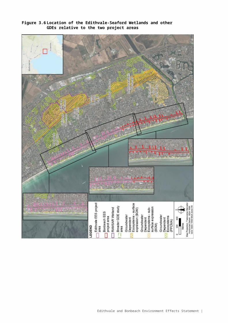
Figure 3.6 Location of the Edithvale-Seaford Wetlands and other GDEs relative to the two project areas

3.4.2 Groundwater dependent ecosystemsThere are several GDEs within the Edithvale and Bonbeach region in addition to the Edithvale Wetland including the Wannarkladdin Wetlands, Edithvale Common, golf courses and the Aspendale to Carrum Foreshore Reserve. These are shown in Figure 3.6 relative to the two project areas.
The risk of the projects impacting the Wannarkladdin Wetlands is negligible as the wetlands do not fall within the zone of predicted changes to groundwater. Vegetation within other GDEs inland of the rail corridor are not anticipated to be affected because the modelled changes to groundwater levels are not significant in those areas, if present at all.
On the coastal side of the rail corridor, the predicted lowering of the water table due to the Bonbeach project has the potential to affect up to 2.1 hectares of foreshore vegetation within the Aspendale to Carrum Foreshore Reserve. The vegetation within the Reserve is of moderate to high quality and has been modified over time but provides a largely continuous habitat corridor, erosion protection and amenity value.
The foreshore vegetation could be impacted by acidification of groundwater or by the loss of access to groundwater. The assessments undertaken for the EES identify a negligible risk of this impact occurring at Edithvale and a minor risk at Bonbeach. To manage the low overall risk of this impact occurring, the EPRs provide for the monitoring of groundwater levels and quality, and the preparation of mitigation measures to be implemented if an impact were to occur.
More information regarding the GDEs is provided in Chapter 6 Edithvale-Seaford Wetlands and groundwater dependent ecosystems.
3.4.3 Native vegetationNative vegetation is present within the rail corridor and would be removed to enable construction of the proposed rail trenches. Conservatively assuming that both project areas would be cleared of all vegetation, the area of affected native vegetation would total 2.2 hectares. This would be substantially minimised in finalising project designs and construction methodologies, clearing only what would be necessary, and offsetting the impacted vegetation in accordance with Victorian Government policy. Affected vegetation does not provide habitat for threatened species.

3.14 Edithvale and Bonbeach Environment Effects Statement |
EES evaluation objectiveTo avoid, minimise and/or offset adverse effects on native vegetation, listed threatened species and ecological communities, listed migratory species, the Ramsar listed Edithvale-Seaford Wetlands, other protected flora and fauna and groundwater dependent ecosystems.
3.4.4 Meeting the evaluation objectiveOverall, the project would meet the evaluation objective of avoiding, minimising and/or offsetting adverse ecological effects through avoiding impacts to the Ramsar listed Edithvale-Seaford Wetlands and the Wannarkladdin Wetlands, as well as offsetting directly impacted vegetation and committing to mitigate any impacts to the foreshore vegetation that are attributed to the projects. No listed threatened species are likely to be impacted by the projects.
3.5 Acid sulfate soils and contaminationA comprehensive soil testing program has been undertaken along both the Edithvale and Bonbeach project areas, with bores tested for both soil and groundwater quality, as discussed below.
3.5.1 Excavation techniquesThe excavation and management of potential acid sulfate soils and contaminated soils can be managedto avoid impacts on human health and the environment. This is because excavation of such soils would take place after the continuous impermeable pile walls at either side of the proposed trenches are constructed. This would prevent groundwater entering the trenches during construction and any water or soil migrating away from the trenches. Potential acid sulfate soils would be managed in accordance with the Victorian Government’s Best practice guidelines for assessing and managing coastal acid sulfate soils 2010, and itis proposed to remove any potentially acidic soil from the project areas immediately following excavation. Testing of soil would be undertaken prior to excavation in accordance with EPA Victoria guidelines to ensure that any contaminated soil is identified and managed appropriately.
3.5.2 Acid sulfate soilsAcid sulfate soils occur naturally in the environment and contain minerals such as iron sulfide. When exposed to air they can react with oxygen and may produce acidic run-off and odours, potentially affecting beneficial uses. In a coastal context, they are known as Coastal Acid Sulfate Soils (CASS).
Within the project areas, potential acid sulfate soils are present between 4 to 15 metres below ground level at Edithvale and 3.5 to 16 metres below ground level at Bonbeach. These soils do not occur as a solid and regular band, but rather as discontinuous and irregular patches and are predicted to occur within the pink band shown in Figure 3.7 (at Edithvale) and Figure 3.8 (at Bonbeach).
CASS are relevant in two ways:• They are likely to be present within soils excavated for piling and the trenches.• Drawdown of groundwater has the potential to expose buried CASS to air.
These are discussed in the following pages.
Edithvale and Bonbeach Environment Effects Statement | Key findings 3.15
Figure 3.7 Conceptual and indicative depth of CASS at Edithvale

3.16 Edithvale and Bonbeach Environment Effects Statement |
Figure 3.8 Conceptual and indicative depth of CASS at Bonbeach
Edithvale and Bonbeach Environment Effects Statement | Key findings 3.17
Excavation of CASSThe key finding regarding CASS is that they would almost certainly be encountered during excavations. Modelling indicates that a total volume of 51,870 cubic metres of CASS from both projects would require management in accordance with well established guidelines and practices developed by the EPA Victoria and the Victorian Government, including:
• EPA Victoria Publication 655.1 Information Bulletin: Acid Sulfate Soil and Rock 2009• Industrial Waste Management Policy (Waste Acid Sulfate Soils) 1999 (IWMP)• Victorian Best Practice Guidelines for Assessing and Managing Coastal Acid Sulfate Soils 2010.
These guidelines outline measures for handling CASS to minimise potential impacts, and require that disposal of CASS occurs only at a facility licenced to receive it.
Drawdown of groundwater potentially activating CASSAs identified in Section 3.3, drawdown of groundwater is modelled to occur at Bonbeach. With groundwater predicted to drawdown to a depth that is approximately level to the top of the CASS band in two limited areas, it is considered that any potential acid sulfate soils in these two limited areas would be activated. However, the areas of potential acid sulfate soils are relatively small and may already have been activated by natural lowering of the water table. This is supported by the groundwater results for the shallow aquifer which shows the presence of existing acidity. Monitoring of groundwater quality would be undertaken in accordance with the EPRs to ensure any potential acidification of groundwater likely to impact beneficial uses would be prevented.
3.5.3 ContaminationBased on the investigations undertaken, it is expected that some of the soil to be excavated would be contaminated through existing and historical land uses, such as the use of fill material in the rail corridor, and adjacent land uses such as a fire station, service stations and drycleaners. Contaminants such as metals, hydrocarbons, asbestos and other industrial chemicals are considered likely to be present in some of the soil excavated.
While there are no sites along the project areas which the EPA Victoria has registered as particularly contaminated, a number of environmental audits have been undertaken within 500 metres of both project areas which identified contaminants such as metals, hydrocarbons and elevated nutrientsat the relevant sites.
ConstructionWhen soils are excavated, they are categorised and must be managed in accordance with EPA Victoria policy. Categories are fill (or clean soil), or Category A, B or C, with Category A representing the most contaminated material.
Based on the sampling undertaken to date, approximately 40,000 cubic metres of excavated soils across both projects would be classified as Category C material, requiring disposal at a licenced facility. Approximately 100 cubic metres may be classified as Category A or B. Appropriately licenced sites with sufficient capacity are available, and one or more suitable licenced facilities in the region would be determined closer to the construction date, subject to other concurrent projects. All disposal sites are accessible from the project sites via Station Street and arterial roads that are designated for the movement of heavy vehicles.
The assessments undertaken during the preparation of the EES identified that the risk to human health and the environment, from odours and in regard to excavating, transporting and disposing of contaminatedmaterial in accordance with EPA Victoria's policies and requirements, is negligible. A more detailed sampling program would be undertaken prior to the commencement of excavation to assess the quality of soils in accordance with the EPA’s Industrial Waste Resource Guidelines. With no re-use opportunities or room for stockpiling excavated soils within the project areas, all excavated soils would be transported directly offsite.

EES evaluation objectiveTo prevent adverse environmental or health effects from disturbing, storing or influencing the movement/transport of contaminated or acid-forming material.
3.18 Edithvale and Bonbeach Environment Effects Statement |
OperationDrawdown and mounding of groundwater as a result of the proposed trenches has the potential to locally change the direction of groundwater flows which could also result in the movement of any existing contaminant plumes. While modelling of the proposed project design at Bonbeach indicates the potential for this impact to occur, further detailed design development in accordance with the EPRs developed for the projects would ensure that water quality is not impacted to the extent that beneficial uses of groundwater are precluded.
The project would not result in any significant additional contamination of soil or groundwater. Acidificationof small pockets of potential acid sulfate soils may occur at Bonbeach as a result of drawdown of groundwater, however, this potential impact would be monitored and managed if required. Minor changes to the directionof existing groundwater plumes is possible, however, no plumes of contaminated groundwater have been identified in the studies undertaken for the EES.
3.5.4 Meeting the evaluation objectiveOverall, the projects would meet the evaluation objective to prevent adverse environmental or health effects from disturbing, storing or influencing the movement of contaminated or acid-forming material, and ensuring designs protect beneficial uses. Excavation of material that is likely to be contaminated would be unavoidable, however, implementation of well-defined and established practices to manage environmental and human health risks would be implemented.

Edithvale and Bonbeach Environment Effects Statement | Key findings 3.19
3.6 Informing the Environmental Management Framework
This section summarises the potential environmental effects during construction and operation at both project sites that may require management through an Environmental Management Framework, as required by Section 3.5 of the Scoping Requirements.
The potential impacts to the community during the construction of the two projects are typical of any construction project, in terms of the following issues:• Traffic – Traffic management and ensuring safe movement of vehicles, pedestrians and cyclists around the
construction activity, including the safe and efficient movement of construction traffic through the community.
• Access – Pedestrian, cyclist and vehicle access across the rail corridor is a particular considerationfor the community and businesses alike and would be impacted at times, most notably during the major rail occupation period of major construction activity. Alternative routes would be available at all times.
• Noise – Construction noise would be an issue and managed in accordance with EPA Victoria requirements during the construction activity scheduled to occur prior to and following the main occupation. EPA Victoria Publication 1254 Noise Control Guidelines 2008 provides guidance to contractors which would be incorporated into the day-to-day activities. During the main rail occupation, works would occur 24 hoursa day to minimise the duration of disruption to rail users and the local communities. As a result, the most affected residences may be eligible for relocation during the works, subject to criteria that would be developed in conjunction with the detailed design and construction methodology.
• Air quality – Air quality may be affected by vehicle emissions and dust, both of which would be managedin accordance with EPA Victoria Publication 480 Best Practice Environmental Management: Environmental guidelines for major construction sites 1996.
These issues, alongside the visual appearance of construction activity, can be considered cumulatively as an impact to amenity for the local communities and businesses, and are necessary to remove the dangerous and congested level crossings. The EPRs for the projects require comprehensive environmental and traffic management plans to be implemented to ensure legislative and policy requirements are met.An extensive program of community and stakeholder consultation would also be undertaken prior to and during construction to ensure that the community, particularly residents and businesses that may potentially be directly affected, are aware of upcoming works and are able to plan their activities.

3.20 Edithvale and Bonbeach Environment Effects Statement |
The local community and commuters reliant on the Frankston rail line would benefit from the removal of the two level crossings. While there are broad-reaching benefits for the community, there would be localised impacts associated with the trenches for some adjacent residents.
During operation, changes are both positive and negative, and relate to visual amenity of the area associated with the upgraded station and railway infrastructure, loss of existing vegetation as well as planting of new vegetation and construction of new infrastructure, particularly the safety barriers and footbridges and noise, as follows:
• Noise – Noise modelling confirms that the projects would not exceed the investigation thresholds in the Victorian Government’s Passenger Rail Infrastructure Noise Policy 2013. This means that the noise from trains using the new infrastructure is within the limits set under the policy and does not require mitigation or management.
• Visual amenity – The areas surrounding the projects are highly valued for their coastal setting. The projects would change the visual appearance of the transport corridor through Edithvale and Bonbeach by replacing the existing at-grade rail infrastructure with a modern station building and precinct, car parking on deck, footbridges, safety barriers along the trench and a substation at Edithvale.
3.7 Summary of key findingsThe projects would remove two dangerous and congested level crossings, and contribute to significant improvements in the capacity, efficiency and reliability of the Frankston rail line, and create safer and more vibrant precincts for the two suburbs.
Like all infrastructure projects, their construction and operation would change the local setting and potentially affect the local environment, particularly during construction. The construction activity would be disruptive, particularly to those who live adjacent to the works. However, the disruption would be temporary and LXRA would work closely with those affected to ensure a high level of communication is maintained throughout the construction period, which would ultimately deliver a high quality urban outcome that creates a much safer environment for residents of, and visitors to, Edithvale and Bonbeach.
Once the railway is in trenches, potential effects of the projects would be associated with changes to the shallow groundwater levels through both Edithvale and Bonbeach. The detailed designs of the projects would be developed in accordance with the EPRs set out in Chapter 9 Environmental Management Framework, which would ensure that the potential effects are effectively managed and mitigated such that the evaluation objectives are met. Critically, it is considered almost impossible for the projects to affect the Edithvale-Seaford Wetlands as groundwater changes are not predicted to occur within 1,000 metres of the wetlands.
The initial groundwater model prepared for the EES predicted that the trench proposed at Edithvale would result in groundwater mounding on the inland side that could potentially increase the frequency of water logging that already occurs on occasion in the Edithvale area. The same impact was not identified at Bonbeach.
In response to the risk of water logging, activation of acid sulfate soils and a potential increase in the salinity of groundwater, an engineering solution was developed to enable groundwater to flow around the trench structure at Edithvale and reduce the potential mounding to within natural variability. The engineering solution was then tested using the groundwater model to confirm it would be effective to reduce groundwater mounding so that it would not result in additional water logging.
Groundwater drawdown between the trenches and the coast may affect a small area of coastal vegetation and acid sulfate soils, but through implementing the EPRs, beneficial uses of groundwater would not be impacted. The assessment has not identified any potential impacts to human health or recreation.
Table 3.1 provides a summary of the key findings.
On balance and in considering these findings, LXRA considers that the three evaluation objectives established by the Scoping Requirements have been met.

Edithvale and Bonbeach Environment Effects Statement | Key findings 3.21
Table 3.1 Summary of key findings
Topic Key finding Further information
Potential impactsto regional groundwater
Section 3.3
The proposed trench at Edithvale has the potential to exacerbate existing water logging as a result of groundwater intersecting with the surface. The project would be designed to avoid this impact and ensure no significant impacts tothe environment occur. An engineering solution has been developed and modelled using the independently peer reviewed groundwater model prepared for the EES to demonstrate this outcome is achievable.
Groundwater flows in a different direction at Bonbeach compared to Edithvale and mounding is not predicted to cause waterlogging at this project.
Chapter 5 Modelling the water environment
Technical Report AGroundwater
Edithvale Wetland
Section 3.4.1
Given the distances between the Edithvale Wetland and the project sites (1.3 kilometres from the existing Edithvale Road level crossing and two kilometres from Bonbeach), the works would not directly impact the wetlands through, for example, loss of vegetation or disturbance to bird species.
Furthermore, the groundwater modelling predicts that the effect of the trenches on regional groundwater wouldreturn to background levels at least one kilometre from the wetlands, such that the hydrological regime and ecological character of the wetlands would not be affected. The Edithvale-Seaford Wetlands would therefore continue to meet the applicable Ramsar listing criteria.
Chapter 6 Edithvale- Seaford Wetlands and groundwater dependent ecosystems
Technical Report B Ecology: Wetlands and GroundwaterDependent Ecosystems
Groundwater dependent ecosystems
Section 3.4.2
Terrestrial GDEs exist in a naturally variable environment in which water is accessed via the surface or groundwater. Both sources naturally fluctuate based on long-term climatic conditions and the prevailing weather and as such terrestrial GDEs must be adaptable and resilient to these variable conditions. Given the small change in groundwater predicted through the model it is likely changes to vegetation will be minor or negligible.
Chapter 6 Edithvale- Seaford Wetlands and groundwater dependent ecosystems
Technical Report B Ecology: Wetlands and GroundwaterDependent Ecosystems
Native vegetation
Section 3.4.3
Native vegetation is present within the rail corridor and would be removed to enable construction of the proposed rail trenches. Conservatively assuming that both project areas would be cleared of all vegetation, the area of affected native vegetation would total 2.2 hectares. This would be substantially minimised in finalising project designs and construction methodologies, clearing only what is necessary, and offsetting the impacted vegetation in accordance with Victorian Government policy.
Chapter 8 Potential local impacts at Edithvale and Bonbeach
Technical Report DEcology: Project Areas
Acid sulfate soils and contamination
Section 3.5
The projects would prevent adverse environmental or health effects from disturbing, storing or influencing the movement of contaminated or acid-forming material, and be designed to protect beneficial uses. Excavation of material that is likely to be contaminated would be unavoidable, however implementation of well-defined and established practicesto manage environmental and human health risks would be implemented.
Chapter 7 Acid sulfate soils and contamination
Technical Report C Acid Sulfate Soils and Contamination

3.22 Edithvale and Bonbeach Environment Effects Statement |
Topic Key finding Further information
Construction impacts
Section 3.6
Construction would result in localised amenity impacts related to noise and transport network disruption, but can be managed effectively using well established practices.
The potential impacts to the community during the construction of the two projects are typical of any construction project.
Comprehensive environmental and traffic management plans would be implemented to ensure legislative and policyrequirements are met, and an extensive program of community and stakeholder consultation would be undertaken prior to and during construction to ensure that the community, particularly residents and businesses that may potentially be directly affected, are aware of upcoming works and are able to plan their activities.
Chapter 8 Potential local impacts at Edithvale and Bonbeach
Technical Reports E to N
Noise during operations
Section 3.6
Noise modelling confirms that the projects would not exceed the investigation thresholds in the Passenger Rail Infrastructure Noise Policy.
Chapter 8 Potential local impacts at Edithvale and Bonbeach
Technical Report HNoise and Vibration
Visual amenity
Section 3.6
The areas surrounding the projects are highly valued for their coastal setting. The projects would change the visual appearance of the transport corridor through Edithvale and Bonbeach by replacing the existing at-grade rail infrastructure with a modern station building and precinct, car parking on deck, footbridges, safety barriers along the trench and a substation at Edithvale. Although vegetation would be lost, new landscaping would be established.
Chapter 8 Potential local impacts at Edithvale and Bonbeach
Technical Report JLandscape and Visual