Embed Size (px)
Citation preview

1
Inventory, Treatment and Management of
State Park Transportation Systems Workshop Objectives
• Process Based Training
• Understand How Consistent Inventory
Procedures Assists Data Management
• Not a GPS/Training
• Not a Access Training
• Support Your Existing Road and Trail
Inventory Management
• CD Provided
A Geographic Information System
of Data Management of Roads and Trails
in California State Parks
A Project Jointly Managed by California State Parks
&
California Geologic Survey
Inventory, Treatment and Management of
State Park Transportation Systems
• Are Constructed by State Parks
• Inherited from Past Land Use
• Adopted User Created Trails
• Non – System User Created Trails
State Park Roads and Trails

2
Organize Lineal Facilities on the
Land Base by Accurate Mapping
• Assemble Existing GIS Layers
– Segmentation
– Categorization
– Classification
GIS Data is Gathered from the Best
Available Source
Data Sources
GPS Data
(Not All Created Equal)
GPS
Knowledgeable Park Staff Input Dynamic Segmentation or
Lineal Referencing of
Roads and Trails
• Segment Roads and Trails at Intersections or Junctions with Other Roads or Trails
• Segment where the Class, Construction Type or Use Type changes
• Don’t create a new segment unless a route extends at least 100 ft.
Trails To
Local
Community
Trail To
USFS
Lands
Trail To
USFS
Lands
Trails To
Local
Community Segmented
Roads and
Trails

3
Overview of the GIS Base Map
• Our Goal is to Create Two GIS Based
Outcomes
1. “Transportation” Layer
• All Facility Roads and Trails Transportation
Elements to the Public
• Sometimes a Dirt Road is Used by the
Public as a Trail
• A Paved Road Route May be Accessible
and Part of a Path of Travel
• A Pave Trail May be Primarily Used as a
Bike Trail But it is Driven on By Park Staff
• Our Goal is to Create Two GIS Based
Outcomes
2. A “Facility” Layer
• Roads and Trails Information Grouped By
Their Respective Construction Type,
Classification and Facility Number
• This Facility Layer is Used for Budgeting,
Maintenance and Administrative
Management
• Attribute Assignment Auto Creates Facility
Numbers
Overview of the GIS Base Map
State Park Roads and Trails
• If the Route Accommodates or was Built for Vehicle access, it is a Road.
– The Roads Class has Three Subclasses: Road, Vehicle Bridge, and Parking
– Roads can have Trail Uses
• Trail Use may even be the Primary Use for a Road Segment
State Park Roads and Trails
• Some Trails are on Abandoned Roads
– If Vehicle Access is No Longer Allowed, it is still a Road and Designated as a “Trail on Old Road”
ROUTECLASS System or Non System
ROUTENAME Trail Name
ALTNAME Alternate Name
ROUTECAT Trail Classification
ROUTETYPE Surface Material
ROUTEDES Accessible/Non Accessible
TRLDES Trail User Types Allowed
OTHERDES Width
SOURCE Digital Data Source
SRC_DATE Source Date
Core Data or Attributes are
Assigned to Each Trail Segment
ROUTECLASS System or Non System
FCC Number of Lanes
ROUTENAME Road Name
ALTNAME Alternate Name
ROUTECAT Public/Service/Trail on Road
ROUTETYPE Surface Material
ROUTEDES Fire Break/Motorized Rec
TRLDES Trail User Types Allowed
OTHERDES Accessible/Not Accessible
SOURCE Digital Data Source
SRC_DATE Source Date
Core Data or Attributes are
Assigned to Each Road Segment

4
California State Parks
Roads and Trails Data Model
• Ease of Entry
whether using
GPS or Desktop
computer.
• Reduces Potential
for Data Entry
Errors.
Attributes for each Subtype Controlled by
Domain Lookup Tables
Web Based Map Attribute Assignments
Data Attribute Establishment,
Gathering and Analysis
• Collaborative Effort
– Resources of Visitor Services, Maintenance, Cultural and Natural Resources
Trail Summary by Facility Number
339-F-1-01-0-001
339-F-1-01-5-001
339-F-3-01-0-001
339-F-1-04-0-001
639-F-1-04-5-001
Road Summary by Facility Number
339-C-2-04-5-00
339-C-1-01-1-001
339-C-1-02-1-001
339-C-1-01-2-001
339-C-1-02-2-001
339-C-1-04-2-001
339-C-1-05-2-001
Segments Can be Assigned
“Transportation” Layer Attributes
– All Facility Roads and Trails are Transportation
Elements to the Public
– Road and Trails have Different Maintenance and
Budget Needs to the Managing Agency
– A Dirt or Paved Road is Often a Trail Route Used
by the Public
– Some Trail Routes Have Multiple Names – Local
Trail Name with Regional Trail Designation
5
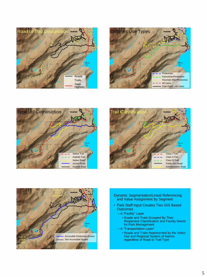
Roads
Trails
State Highway
Road or Trail Designation Different Use Types
Pedestrian
Equestrian/Pedestrian
Mountain Bike/Pedestrian
All Users
Park Road – All Users
Types of Construction
Native Trail
Asphalt Trail
Native Road
Gravel Road
Asphalt Road
Trail Classification
Class I Trail
Class II Trail
Class III Trail
Public Use Road
Administrative Road
Trails To
Local
Community
Trail To
USFS
Lands
Accessible Pedestrian Routes
Non Accessible Routes
Dynamic Segmentation/Lineal Referencing and Value Assignment by Segment
• Park Staff Input Creates Two GIS Based Outcomes
– A “Facility” Layer
• Roads and Trails Grouped By Their Respective Classification and Facility Needs for Park Management
– A “Transportation Layer”
• Roads and Trails Represented by the Visitor Use and Regional System of Names regardless of Road or Trail Type

6
CONDITION ASSESMENT INVENTORY
and
EVALUATION
• Detailed Foot by Foot Inventories
• Road & Trail Features, Condition, Hydrologic Impacts
Assigning Field Inventory Data
• Access Based Tough Book Recording
Field Inventory Data
This Inventory Data – Stored in GIS
Topographic Display
WATER COURSES

7
LANDSLIDES LISTED PLANTS AND ANIMALS
COMPOSITE OVERLAY ALLOWS EFFECTIVE DATA
MANAGEMENT
PRIMARY ACCESS PT.
VISTA POINT
• Organize Unit Roads
and Trails
• Properly Classify and
Assign Facility
Numbers:
– GIS Data Base of
Accurate Inventory
What will Inventory, Treatment and
Management Do?
• Identify:
– What Users Types
are Currently
Assigned to the
Unit’s Roads and
Trails
• What Roads and
Trails will They
Share
What will Inventory, Treatment and
Management Do?
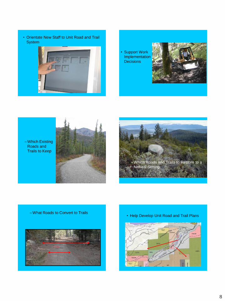
8
• Orientate New Staff to Unit Road and Trail
System
• Support Work
Implementation
Decisions
– Which Existing
Roads and
Trails to Keep
– Which Roads and Trails to Restore to a
Natural Setting
– What Roads to Convert to Trails • Help Develop Unit Road and Trail Plans

9
• Identify:
– What Kind of
Monitoring is
Needed
Field Exercises Safety
Hat
Boots
Layering
Water
Gloves
Day Packs
Lunch
Steep Hillsides
Loose Footing
Poison Oak
Ticks
Overexertion
Personal Items