Embed Size (px)
Citation preview

Inverness and the Great Glen (Potentially Vulnerable
Area 01/21)
Local Plan District
Highland and Argyll
Local authority Main catchment
The Highland Council River Ness Inverness coastal
Ob
jec
tive
s
Su
mm
ary
of flo
od
ing
imp
ac
ts
Objectives have been set by SEPA and agreed with flood risk management authorities. These are the aims for managing local flood risk. The objectives have been grouped in three main ways: by reducing risk, avoiding increasing risk or accepting risk by maintaining current levels of management.
Many organisations, such as Scottish Water and energy companies, actively maintain and manage their own assets including their risk from flooding. Where known, these actions are described here. Scottish Natural Heritage and Historic Environment Scotland work with site owners to manage flooding where appropriate at designated environmental and/or cultural heritage sites. These actions are not detailed further in the Flood Risk Management Strategies.
Summary of objectives to manage flooding
Summary of flooding impacts
• 1,400 residential properties• 380 non-residential properties• £5.6 million Annual Average Damages (damages by flood source shown left)
At risk of flooding
Ac
tion
s
The actions below have been selected to manage flood risk.
Summary of actions to manage flooding
Maintain flood warning
Site protection plans
MaintenanceSelf helpMaintain flood
protection scheme
Strategic mapping and
modelling
Flood forecasting
Emergency plans/response
Community flood action
groups
Awareness raising
Planning policies
Surface water plan/study
New flood warning
Property level protection
scheme
Natural flood management
works
Natural flood management
study
Flood protection
scheme/works
Flood protection
study
Flood protection
study
Flood protection
scheme/works
Natural flood management
study
Surface water plan/study
Planning policies
Awareness raising
Community flood action
groups
Emergency plans/response
Flood forecasting
Strategic mapping and
modelling
Maintain flood protection
scheme
Self help Maintenance
Maintain flood warning
Highland and ArgyllLocal Plan District
Section 2 224
Inverness and the Great Glen (Potentially Vulnerable Area 01/21)
Local Plan District Local authority Main catchments
Highland and Argyll The Highland Council River Ness,
Inverness coastal
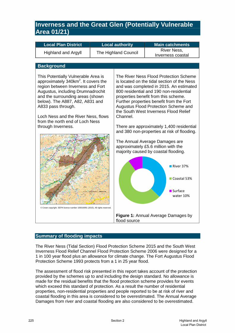
Background This Potentially Vulnerable Area is approximately 340km2. It covers the region between Inverness and Fort Augustus, including Drumnadrochit and the surrounding areas (shown below). The A887, A82, A831 and A833 pass through. Loch Ness and the River Ness, flows from the north end of Loch Ness through Inverness.
© Crown copyright. SEPA licence number 100016991 (2015). All rights reserved.
The River Ness Flood Protection Scheme is located on the tidal section of the Ness and was completed in 2015. An estimated 800 residential and 190 non-residential properties benefit from this scheme. Further properties benefit from the Fort Augustus Flood Protection Scheme and the South West Inverness Flood Relief Channel. There are approximately 1,400 residential and 380 non-properties at risk of flooding. The Annual Average Damages are approximately £5.6 million with the majority caused by coastal flooding.
River 37%
Coastal 53%
Surfacewater 10%
Figure 1: Annual Average Damages by flood source
Summary of flooding impacts The River Ness (Tidal Section) Flood Protection Scheme 2015 and the South West Inverness Flood Relief Channel Flood Protection Scheme 2006 were designed for a 1 in 100 year flood plus an allowance for climate change. The Fort Augustus Flood Protection Scheme 1993 protects from a 1 in 25 year flood. The assessment of flood risk presented in this report takes account of the protection provided by the schemes up to and including the design standard. No allowance is made for the residual benefits that the flood protection scheme provides for events which exceed this standard of protection. As a result the number of residential properties, non-residential properties and people reported to be at risk of river and coastal flooding in this area is considered to be overestimated. The Annual Average Damages from river and coastal flooding are also considered to be overestimated.
225 Section 2 Highland and ArgyllLocal Plan District

Coastal flood risk in the area is focussed on South Kessock and adjacent to the Muirtown Basin in Merkinch. There are areas of river flood risk in Inverness particularly those associated with the River Ness and the Mill Burn. River flood risk in Drumnadrochit is primarily from the River Enrich. There are areas of surface water flood risk spread throughout the area which is frequently associated with small, often culverted, watercourses in urban areas. The risk of flooding to people and property, as well as to community facilities, utilities, the transport network, designated sites and agricultural land is summarised in Table 1. The risk of flooding to utilities in Table 1 does not include Scottish Water data. Scottish Water undertook a national assessment of above ground assets at medium likelihood of flooding (including water treatment works, wastewater treatment works, and pumping stations). Within this Potentially Vulnerable Area there are seven assets identified as being at risk of flooding. Roads at risk include the A82, A833, A831, B862 and B861. The Inverness to Aberdeen, Inverness to Perth, and Inverness to Wick railway lines are at risk of flooding in several locations. There are 46 designated cultural heritage sites, an area of environmental importance and agricultural land at risk. The damages associated with floods of different likelihood are shown in Figure 2. For this Potentially Vulnerable Area the highest damages are to non-residential properties followed by damages to residential properties. The location of the impacts of flooding is shown in Figure 3.
Highland and ArgyllLocal Plan District
Section 2 226

1 in 10 1 in 200 1 in 1000
High likelihood Medium likelihood Low likelihood
Residential properties (total 24,000)
560 1,400 5,900
Non-residential properties (total 3,000)
120 380 1,300
People 1,200 3,100 13,000
Community facilities
0
<10 Includes; educational
buildings and healthcare
facilities
20 Includes; educational buildings,
healthcare facilities and emergency
services
Utilities assets 10 40 110
Transport links (excluding minor roads)
Roads at 270 locations
Rail at <10 locations
Roads at 490 locations
Rail at 10 locations
Roads at 730 locations
Rail at 40 locations
Environmental designated areas (km
2)
1 1 1
Designated cultural heritage sites
39 46 49
Agricultural land (km
2)
3 4 4
Table 1: Summary of flooding impacts1
Figure 2: Damages by flood likelihood
1 Some receptors are counted more than once if flooded from multiple sources
227 Section 2 Highland and ArgyllLocal Plan District
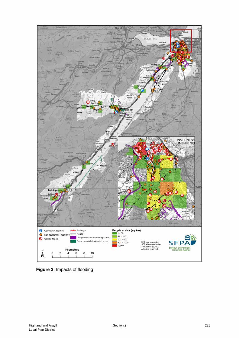
Figure 3: Impacts of flooding
Highland and ArgyllLocal Plan District
Section 2 228

History of flooding There have been numerous floods recorded in this Potentially Vulnerable Area.
Inverness
The earliest recorded flood on the River Ness was in 1644. There are records of floods on the River Ness in 1815, 1834, 1845, 1846, 1856, 1860, 1863, 1868 (joint tidal event), 1869 (joint tidal event), 1873, 1874, 1875, 1878, 1880, 1886, 1892, 1894, 1895, 1903, 1928, 1949, 1956, 1962, 1966, 1989, 2005, 2006, 2007 and 2008. The most damaging floods were in 1956 and 1989. Both were caused by the River Ness flooding in combination with high tides. These floods caused damages to property, roads and the railway line. The River Ness also flooded in 1990 and 2005 due to high river flows and high tides. The River Ness Flood Protection Scheme aims to reduce the risk during similar future events. The Ault na Skiah system, which includes Lochardil Burn, Slackbuie Channel and other watercourses, had significant floods in 1989, 1997, 1998, 1999 and 2000. Damage was caused to property in Hilton, Lochardil, Castle Heather and Slackbuie areas of Inverness. The Mill Burn had significant floods in 1989, 1997, 1998, 1999, 2000, 2006, 2011 and 2014. These floods caused damage to property in Old Edinburgh Road, Merlin Crescent, Falcon Avenue, Teal Avenue, Harris Road, Diriebught Road. The Dell Burn flooded in 2002, mainly affecting the retail park.
Drumnadrochit
The River Enrick in Glen Urquhart flooded in 1818 destroying three bridges, and again in 1829 along with the River Coiltie. A flood in 1892 destroyed five bridges on the River Enrick. Four bridges were lost in the 1950s and again in the early 1990s. There were floods in 1908, 1909, 1910, 1913, 1920, 1932 (including River Coiltie), 1950, 1956, 1990, 1993, 1994, 1997, 1999, 2000, 2006, and 2007. The Clunbeg bridge on the River Coiltie was also reported to be lost in the 1950s and 1990s. The 1990 flood also affected Kilmichael. Kilmichael was also reported to be affected by flooding in 2010, 2013 and 2015. Flooding has also been reported in Lewiston from the River Coiltie.
Fort Augustus
Flooding occurred from the River Oich in 1849, 1966, 1989 and 1990. The flooding mainly affected the Riggs area of Fort Augustus.
229 Section 2 Highland and ArgyllLocal Plan District
Objectives provide a common goal and shared ambition for managing floods. These objectives have been set by SEPA and agreed with flood risk management authorities following consultation. They were identified through an assessment of the underlying evidence of the causes and impacts of flooding. Target areas have been set to focus actions; they do not necessarily correspond to areas at risk in SEPA’s flood map. The objectives below have been set for Inverness and the Great Glen Potentially Vulnerable Area.
Objectives to manage flooding in Potentially Vulnerable Area 01/21
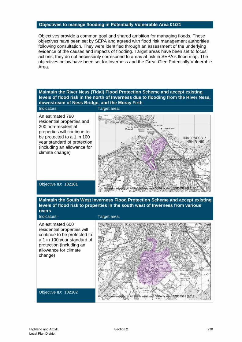
Maintain the River Ness (Tidal) Flood Protection Scheme and accept existing
levels of flood risk in the north of Inverness due to flooding from the River Ness,
downstream of Ness Bridge, and the Moray Firth
Indicators:
An estimated 790 residential properties and 200 non-residential properties will continue to be protected to a 1 in 100 year standard of protection (including an allowance for climate change)
Objective ID: 102101
Target area:
Image found and displayed.
©Crown copyright. All rights reserved. SEPA lic.no. 100016991 (2015)
Maintain the South West Inverness Flood Protection Scheme and accept existing
levels of flood risk to properties in the south west of Inverness from various
rivers
Indicators:
An estimated 600 residential properties will continue to be protected to a 1 in 100 year standard of protection (including an allowance for climate change)
Objective ID: 102102
Target area:
Image found and displayed.
©Crown copyright. All rights reserved. SEPA lic.no. 100016991 (2015)
Highland and ArgyllLocal Plan District
Section 2 230

Reduce flood risk in Inverness from the Mill Burn
Indicators:
• 210 people• £41,000 Annual Average Damages from residential properties• £1,000 Annual Average Damages from non-residential properties
Objective ID: 102103
Target area:
Image found and displayed.
©Crown copyright. All rights reserved. SEPA lic.no. 100016991 (2015)
Maintain the Fort Augustus Flood Protection Scheme and accept existing levels
of flood risk in Fort Augustus
Indicators:
An estimated 30 properties will continue to be protected to a 1 in 25 year standard of protection
Objective ID: 102104
Target area:
Image found and displayed.
©Crown copyright. All rights reserved. SEPA lic.no. 100016991 (2015)
231 Section 2 Highland and ArgyllLocal Plan District

Reduce flood risk in Drumnadrochit from the River Enrick
Indicators:
• £46,000 Annual Average Damages from residential properties• £850 Annual Average Damages from non-residential properties• 1 emergency service
Objective ID: 102105
Target area:
Image found and displayed.
©Crown copyright. All rights reserved. SEPA lic.no. 100016991 (2015)
Reduce flood risk in Inverness from the River Ness between Ness Bridge and
Ness Islands
Indicators:
• 250 people• £98,000 Annual Average Damages from residential properties• £65,000 Annual Average Damages from non-residential properties
Objective ID: 102106
Target area:
Image found and displayed.
©Crown copyright. All rights reserved. SEPA lic.no. 100016991 (2015)
Highland and ArgyllLocal Plan District
Section 2 232

Reduce risk in the South Kessock area of Inverness from coastal flooding
Indicators:
• 930 people• £830,000 Annual Average Damages from residential properties• £73,000 Annual Average Damages from non-residential properties
Objective ID: 102107
Target area:
Image found and displayed.
©Crown copyright. All rights reserved. SEPA lic.no. 100016991 (2015)
Target area Objective ID Indicators within
PVAInverness 102109 * See note belowReduce risk from surface water flooding in
Inverness
Applies across Highland and Argyll Local Plan District
100001 • 1,400 residential properties• £5.6 million Annual Average Damages
Avoid an overall increase in flood risk
Applies across Highland and Argyll Local Plan District
100002 • 1,400 residential properties• £5.6 million Annual Average Damages
Reduce overall flood risk
Applies across Highland and Argyll Local Plan District
Organisations such as Scottish Water, energy companies and Historic Environment Scotland actively maintain and manage their own assets, including the risk of flooding. These actions are not detailed further in the Flood Risk Management Strategies.
* This objective will be monitored using surface water flood risk across the Potentially Vulnerable Area. For 01/21 there are 440 residential properties at risk and Annual Average Damages of £560,000.
233 Section 2 Highland and ArgyllLocal Plan District

Actions describe where and how flood risk will be managed. These actions have been set by SEPA and agreed with flood risk management authorities following consultation. Selection of actions to deliver the agreed objectives was based on a detailed assessment and comparison of economic, social and environmental criteria. The actions shaded and then described below have been selected as the most appropriate for Inverness and the Great Glen Potentially Vulnerable Area.
Selected actions
Actions to manage flooding in Potentially Vulnerable Area 01/21
Maintain flood warning
Site protection plans
MaintenanceSelf helpMaintain flood
protection scheme
Strategic mapping and
modelling
Flood forecasting
Emergency plans/response
Community flood action
groups
Awareness raising
Planning policies
Surface water plan/study
New flood warning
Property level protection
scheme
Natural flood management
works
Natural flood management
study
Flood protection
scheme/works
Flood protection
study
Flood protection
study
Flood protection
scheme/works
Natural flood management
study
Surface water plan/study
Planning policies
Awareness raising
Community flood action
groups
Emergency plans/response
Flood forecasting
Strategic mapping and
modelling
Maintain flood protection
scheme
Self help Maintenance
Maintain flood warning
A flood protection scheme in the form of direct defences is under development for Drumnadrochit to reduce flood risk from the River Enrick. The scheme is being designed to a standard of 1 in 200 years. The scheme will be complemented by further investigations of the potential for natural flood management on the tributaries upstream of Drumnadrochit.
The Highland Council
Under development Indicative delivery: 2016-2021
Action (ID): FLOOD PROTECTION SCHEME/WORKS (1021050021)
Description:
Objective (ID):
Delivery lead:
Status:
Reduce flood risk in Drumnadrochit from the River Enrick (102105)
31 of 42 3 of 3
National: Within local authority:Priority:
Approximately 40 people at risk of flooding may directly benefit from flood protection works. A reduction in flood risk would have a positive benefit to the health and wellbeing of the community and socially vulnerable people. There are potential visual and access impacts for the community, reducing their connection to the watercourse. An emergency services facility may also benefit from flood protection works, along with roads including a key transport route (the A831) and a telecommunications utility site which could reduce disruption to the wider community.
A flood protection scheme could reduce the impact of the flooding of 18 residential and 6 non-residential properties. Estimated damages avoided of £1 million could potentially be achieved. The benefit cost ratio of the proposed works is 1.44
Potential impacts
Economic:
Social:
Highland and ArgyllLocal Plan District
Section 2 234

Flood protection works can have both positive and negative impacts on the ecological quality of the environment depending on how they are designed. There is potential for impacts on habitats and changes to channel morphology. Opportunities to mitigate any environmental impacts should be identified as part of the study through the design and timing of works. To be in accord with the FRM Strategy, the responsible authority (and where applicable, the licensing authority) should seek to ensure as part of the study that the action will not have an adverse effect on the integrity of the North Inverness Lochs Special Protection Area and Urquhart Bay Wood Special Area of Conservation. The flood protection works would be located outside of the Urquhart Bay Wood Site of Special Scientific Interest and unlikely to have any significant impacts.
Environmental:
Flood protection works are under development to reduce flood risk from the Mill Burn. The works are likely to be designed to a 1 in 200 year standard of protection, including an allowance for climate change. The design is to be finalised and may include a combination of flood walls and sheet piling, embankments and a culvert upgrading. Progressing the scheme is subject to obtaining a satisfactory business case for the preferred design including economic and environmental factors.
The Highland Council
Under development Indicative delivery: 2016-2021
Action (ID): FLOOD PROTECTION SCHEME/WORKS (1021030006)
Description:
Objective (ID):
Delivery lead:
Status:
Reduce flood risk in Inverness from the Mill Burn (102103)
The development of flood protection works could potentially reduce risk to an estimated 605 people. A reduction in flood risk would have a positive benefit to the health and wellbeing of the community and socially vulnerable people.
Flood protection works can have both positive and negative impacts on the ecological quality of the environment depending on how they are designed. There is potential for impacts on habitats and changes to channel morphology. Opportunities to mitigate any environmental impacts or should be identified as part of the study through the design and timing of works. Mill Burn (water body ID 20239) is located within the study area and has been identified by SEPA to be at less than good physical condition. Opportunities to improve the condition of the river should be considered by coordinating with river basin management planning.
The scheme could reduce flood risk to 275 residential properties, and avoid damages of £4 million. The benefit-cost ratio of the proposed works is 1.1.
Potential impacts
Economic:
Social:
Environmental:
235 Section 2 Highland and ArgyllLocal Plan District
A study is needed to assess the standard of protection of existing embankments and whether they need to be improved. The study should consider wave action and combined flooding from the River Ness and Moray Firth. The study should build on existing information available.
The Highland Council
Not started Indicative delivery: 2016-2021
Action (ID): FLOOD PROTECTION STUDY (1021070005)
Description:
Objective (ID):
Delivery lead:
Status:
Reduce risk in the South Kessock area of Inverness from coastal flooding (102107)
8 of 168 1 of 23
National: Within local authority:Priority:
Improved understanding of the flood extents will confirm the number of properties at risk in South Kessock from coastal flooding along the western frontage of Inverness. Currently it is estimated that 930 people benefit from the existing embankments. A reduction in flood risk would have a positive benefit to the health and wellbeing of the community and socially vulnerable people. Negative impacts through disturbance to the local community during the construction phase should be considered.
Flood protection studies should consider the positive and negative impacts of proposed actions on the ecological quality of the environment. Opportunities to mitigate any environmental impacts may include design and timing of works. To be in accord with the FRM Strategy, the responsible authority should seek to ensure as part of the study that the action will not have an adverse effect on the integrity of the Moray Firth Special Area of Conservation and Inner Moray Firth Special Protection Area.
The flood protection study should consider how to improve flood protection to 422 residential and 24 non-residential properties. Potential damages avoided of up to £28 million could be achieved. It is likely that these damages avoided are over-estimated and the study should look to confirm the benefits provided by existing embankments.
Potential impacts
Economic:
Social:
Environmental:
The Highland Council
Not started Indicative delivery: 2016-2021
Action (ID): FLOOD PROTECTION STUDY (1021060005)
Objective (ID):
Delivery lead:
Status:
Reduce flood risk in Inverness from the River Ness between Ness Bridge and Ness Islands (102106)
88 of 168 6 of 23
National: Within local authority:Priority:
Highland and ArgyllLocal Plan District
Section 2 236

The Upper Ness scheme was previously developed to Planning and Flood Prevention Order stage, but not progressed to construction due to public objections and a weak business case. It is recommended that the previously proposed scheme is reviewed. Other actions may also be considered to develop the most sustainable range of options.
Description:
Approximately 249 people may directly benefit from flood protection works. The communities of Inverness which may benefit from River Ness (Non-Tidal) Flood Prevention Scheme have a slightly higher than average proportion of vulnerable residents. A reduction in flood risk would have a positive benefit to the health and wellbeing of the community and socially vulnerable people. There may also be benefits for local roads and an energy production/electricity utility site, which may reduce disruption to the wider community. In addition there may be reduced flooding to amenities, including public open spaces and the miniature railway. There are potential visual and access impacts for the community, reducing their connection to the watercourse. Negative impacts through disturbance to the local community during the construction phase should be considered.
Flood protection studies should consider the positive and negative impacts of proposed actions on the ecological quality of the environment. Opportunities to mitigate any environmental impacts may include design and timing of works. There is potential for impacts on habitats and changes to channel morphology. There is potential for impacts on the Inverness Riverside conservation area. The flood protection works would be outside of the Torvean Landforms Site of Special Scientific Interest, and there are unlikely to be any significant impacts. The physical condition of the River Ness (water body ID 23394) is identified by river basin management planning to be at less than good status. Future works could improve the condition of the river or degrade it. Opportunities to improve the condition of the river should be considered by coordinating with river basin management planning.
The business case for flood protection works will need to be developed further as part of the study to fully justify flood protection works. Flood protection works could reduce the impact of flooding to 113 residential and 49 non-residential properties, with potential damages avoided of up to £3.9 million.
Potential impacts
Economic:
Social:
Environmental:
A study is recommended to investigate options for the use of natural flood management actions to help reduce flood risk for Drumnadrochit in high likelihood floods. The study should build on the work previously carried out by the Glen Urquhart Land Use Partnership and should cover the full range of runoff control
The Highland Council
Not started Indicative delivery: 2016-2021
Action (ID): NATURAL FLOOD MANAGEMENT STUDY (1021050003)
Description:
Objective (ID):
Delivery lead:
Status:
Reduce flood risk in Drumnadrochit from the River Enrick (102105)
237 Section 2 Highland and ArgyllLocal Plan District

measures, the use of floodplain and riparian woodland, and large woody debris and boulders in the tributaries of the River Enrick to slow their flow (river or floodplain restoration action), and sediment management. Other natural flood management actions may also be considered in order to develop the most sustainable range of options. The study should look to confirm the extent and type of measures required and the business case for natural flood management works. This study should be complimentary to the flood protection works in Drumnadrochit to ensure a coordinated response to the flood risk is developed.
Approximately 15 people at high risk of flooding may directly benefit from natural flood management works. A reduction in flood risk would have a positive benefit to the health and wellbeing of the community and socially vulnerable people. In addition roads, including the A831, may also benefit from reduced flood risk, reducing disruption to the wider community. Natural flood management actions can restore and enhance natural environments and create opportunities for recreation and tourism. Negative impacts through disturbance to the local community during the construction phase should be considered.
Flood protection studies should consider the positive and negative impacts of proposed actions on the ecological quality of the environment. Natural flood management actions can have a positive impact by restoring and enhancing natural habitats. Opportunities to mitigate any environmental impacts may include design and timing of works. Natural flood management actions are likely to improve the ecological quality of the river, helping to restore it to a more natural state. To be in accord with the FRM Strategy, the responsible authority should seek to ensure as part of the study that the action will not have an adverse effect on the integrity of the North Inverness Lochs Special Protection Area and Urquhart Bay Wood Special Area of Conservation. There is potential for direct impacts on the Dubh Lochs Site of Special Scientific Interest. The area of potential for runoff reduction is known as the Balmacaan Forest however there is currently no woodland there; there may be historical significance to its clearance and therefore potential for impacts from this action.
There are seven residential properties at high risk of flooding. It is not possible to estimate the potential benefits of natural flood management actions at this stage and the potential benefits should be identified as part of the study.
Potential impacts
Economic:
Social:
Environmental:
The area must be covered by a surface water management plan or plans that set objectives for the management of surface water flood risk and identify the most sustainable actions to achieve the
The Highland Council
Ongoing Indicative delivery: 2016-2021
Action (ID): SURFACE WATER PLAN/STUDY (1021090018)
Description:
Objective (ID):
Delivery lead:
Status:
Reduce risk from surface water flooding in Inverness (102109)
Highland and ArgyllLocal Plan District
Section 2 238
objectives. An integrated catchment study will be carried out to support the surface water management plan process and improve knowledge and understanding of surface water flood risk and interactions with other sources of flooding e.g. with the sewer network, watercourses and the sea.
SEPA will be seeking to incorporate additional surface water hazard mapping information into the flood maps to improve understanding of flood risk. Approximately 2,100km² of improved data is currently available within this Local Plan District.
SEPA
Not started Indicative delivery: 2016-2021
Action (ID): STRATEGIC MAPPING AND MODELLING (1000020016)
Description:
Objective (ID):
Delivery lead:
Status:
Reduce overall flood risk (100002)
Scottish Water will review the assessment of flood risk within the highest risk sewer catchments to improve knowledge and understanding of surface water flood risk.
Scottish Water
Not started Indicative delivery: 2016-2021
Action (ID): STRATEGIC MAPPING AND MODELLING (1000020019)
Description:
Objective (ID):
Delivery lead:
Status:
Reduce overall flood risk (100002)
239 Section 2 Highland and ArgyllLocal Plan District
The River Ness (Tidal) Scheme was completed in 2015. The scheme provides protection to infrastructure, property and the community in the tidal section of the River Ness in Inverness. The scheme should be maintained to ensure the current level of protection continues.
The Highland Council
Existing Indicative delivery: Ongoing
Action (ID): MAINTAIN FLOOD PROTECTION SCHEME (1021010017)
Description:
Objective (ID):
Delivery lead:
Status:
Maintain the River Ness (Tidal) Flood Protection Scheme and accept existing levels of flood risk in the north of Inverness due to flooding from the River Ness, downstream of Ness Bridge, and the Moray Firth (102101)
The South West Inverness Flood Relief Channel was completed in 2006. The scheme provides protection to infrastructure, property and the community in South West Inverness and should be maintained to ensure the current level of protection continues.
The Highland Council
Existing Indicative delivery: Ongoing
Action (ID): MAINTAIN FLOOD PROTECTION SCHEME (1021020017)
Description:
Objective (ID):
Delivery lead:
Status:
Maintain the South West Inverness Flood Protection Scheme and accept existing levels of flood risk to properties in the south west of Inverness from various rivers (102102)
The Fort Augustus Flood Prevention Scheme on the River Oich was completed in 1994. The scheme provides protection to infrastructure, property and the community in Fort Augustus and should be maintained to ensure the current level of protection continues.
The Highland Council
Existing Indicative delivery: Ongoing
Action (ID): MAINTAIN FLOOD PROTECTION SCHEME (1021040017)
Description:
Objective (ID):
Delivery lead:
Status:
Maintain the Fort Augustus Flood Protection Scheme and accept existing levels of flood risk in Fort Augustus (102104)
Highland and ArgyllLocal Plan District
Section 2 240
Continue to maintain the 'Drumnadrochit', 'Glen Urquhart', 'Invermoriston', 'Ness-side' and 'The Riggs, Fort Augustus' flood warning areas which are part of the Ness river flood warning scheme and provide warnings to low lying land, roads and properties.
Continue to maintain the 'Inverness City (Ness Bridge to Friars Bridge)', which takes into account river and tidal interactions, and the 'Inverness Harbour and South Kessock' flood warning areas. Both are part of the Moray Firth coastal flood warning scheme.
SEPA
Existing Indicative delivery: Ongoing
Action (ID): MAINTAIN FLOOD WARNING (1000020030)
Description:
Objective (ID):
Delivery lead:
Status:
Reduce overall flood risk (100002)
The Scottish Flood Forecasting Service is a joint initiative between SEPA and the Met Office that produces daily, national flood guidance statements which are issued to Category 1 and 2 Responders. The service also provides information which allows SEPA to issue flood warnings, giving people a better chance of reducing the impact of flooding on their home or business. For more information please visit SEPA’s website.The Potentially Vulnerable Area is within the ‘Easter Ross and Great Glen’ flood alert area.
SEPA
Existing Indicative delivery: Ongoing
Action (ID): FLOOD FORECASTING (1000020009)
Description:
Objective (ID):
Delivery lead:
Status:
Reduce overall flood risk (100002)
The Glen Urquhart Land Use Partnership (GULUP) is a voluntary, non-profit, community-led limited company which has been in existence for over ten years. It seeks to give the local community a voice in determining and sustainably developing the long term economic and environmental goals for the area (including flood risk) and will work in partnership with any interested organizations to this end.
Community
Existing Indicative delivery: Ongoing
Action (ID): COMMUNITY FLOOD ACTION GROUPS (1021050012)
Description:
Objective (ID):
Delivery lead:
Status:
Reduce flood risk in Drumnadrochit from the River Enrick (102105)
241 Section 2 Highland and ArgyllLocal Plan District

Everyone is responsible for protecting themselves and their property from flooding. Property and business owners can take simple steps to reduce damage and disruption to their homes and businesses should flooding happen. This includes preparing a flood plan and flood kit, installing property level protection, signing up to Floodline and Resilient Communities initiatives, and ensuring that properties and businesses are insured against flood damage.
—
Existing Indicative delivery: Ongoing
Action (ID): SELF HELP (1000020011)
Description:
Objective (ID):
Delivery lead:
Status:
Reduce overall flood risk (100002)
SEPA and the responsible authorities have a duty to raise public awareness of flood risk. Improved awareness of flood risk and actions that prepare individuals, homes and businesses for flooding can reduce the overall impact.From 2016 SEPA will engage with the community through local participation in national initiatives, including partnership working with Neighbourhood Watch Scotland. In addition, SEPA will engage with local authorities and community resilience groups where possible.Local authorities will be undertaking additional awareness raising activities. Further details will be set out in the Local FRM Plan.
Responsible authorities
Existing Indicative delivery: Ongoing
Action (ID): AWARENESS RAISING (1000020013)
Description:
Objective (ID):
Delivery lead:
Status:
Reduce overall flood risk (100002)
Local authorities have a duty to assess watercourses and carry out clearance and repair works where such works would substantially reduce flood risk. They produce schedules of clearance and repair works and make these available for public inspection. Scottish Water undertake inspection and repair on the public sewer network. Asset owners and riparian landowners are responsible for the maintenance and management of their own assets including those which help to reduce flood risk.
The Highland Council, asset / land managers
Existing Indicative delivery: Ongoing
Action (ID): MAINTENANCE (1000020007)
Description:
Objective (ID):
Delivery lead:
Status:
Reduce overall flood risk (100002)
Highland and ArgyllLocal Plan District
Section 2 242

Providing an emergency response to flooding is the responsibility of many organisations, including local authorities, the emergency services and SEPA. Effective management of an emergency response relies on emergency plans that are prepared under the Civil Contingencies Act 2004 by Category 1 and 2 Responders. The emergency response by these organisations is co-ordinated through regional and local resilience partnerships. This response may be supported by the work of voluntary organisations.The Highland Council has a flood monitor on the River Ness at Greg Street Bridge to provide early warning of potential flooding.
Category 1 and 2 Responders
Existing Indicative delivery: Ongoing
Action (ID): EMERGENCY PLANS/RESPONSE (1000020014)
Description:
Objective (ID):
Delivery lead:
Status:
Reduce overall flood risk (100002)
Scottish Planning Policy and accompanying Planning Advice Notes set out Scottish Ministers’ priorities for the operation of the planning system and for the development and use of land. In terms of flood risk management, the policy supports a catchment-scale approach to sustainable flood risk management and aims to build the resilience of our cities and towns, encourage sustainable land management in our rural areas, and to address the long-term vulnerability of parts of our coasts and islands. Under this approach, new development in areas with medium to high likelihood of flooding should be avoided. For further information on the application of national planning policies see Annex 2.
Planning authority
Existing Indicative delivery: Ongoing
Action (ID): PLANNING POLICIES (1000010001)
Description:
Objective (ID):
Delivery lead:
Status:
Avoid an overall increase in flood risk (100001)
Reduce overall flood risk (100002)
243 Section 2 Highland and ArgyllLocal Plan District