Embed Size (px)
Citation preview
ACEPS - 2013
44
Investigation of Geotechnical characteristics of Galle Fort Rampart
A.S. Ranathunga1, A.D.N.C. Madusanka1 , N.H. Priyankara2 and A.M.N. Alagiyawanna2 1 Faculty of Engineering
University of Ruhuna SRI LANKA
2Department of Civil and Environmental Engineering Faculty of Engineering University of Ruhuna
SRI LANKA E-mail: [email protected]
Abstract: Galle fort is the pre-eminent living heritage within the Southern Province of Sri Lanka. However, attention for the work of engineering is less, while a lot of architectural investigations are in a highly active stage. In this study, it was investigated about such ancient geotechnical engineering aspects through exploring the subsurface soil profile. Further, engineering properties of backfill materials were evaluated using conventional laboratory experiments. In addition, a computer based finite element procedure was used to evaluate slope stability of the rampart. Results show that, rampart is entirely constructed on the bed rock and there was a moat in northern part of the rampart to enhance the security of the fort. In addition, it was found that there are some cavities in the western side of the rampart, which can be concluded as the internal transport corridor between bastions within the rampart and prisons or store rooms that has been used in Dutch era. Further, analysis illustrated that stability of the rampart against a rainfall induced slope failure is endurable. This implies the geotechnical engineering knowledge adopted in civil engineering construction even before four hundred years.
Keywords: Cavities, Indigenous knowledge, Moat, Rampart, Slope stability
1 INTRODUCTION
The historical studies play a vigorous role for the progression of civil engineering. Therefore, many advanced nations give priority for the historical studies in the civil engineering. Galle fort is the only living heritage within the Southern Province of Sri Lanka which is in the Bay of Galle on the south-east coast. It was built first in 1558 by the Portuguese, and then comprehensively fortified by the Dutch during the 17
th century (Paranavithana, 2005). It maintains a genteel appearance even after
four centuries. Even though such a significant structure is existed within us, attention for the work of engineering is very poor for the Galle fort, despite the fact that a lot of architectural investigations are in a highly active stage. Albeit being a world heritage, it hardly exist the details of the rampart, such as cross sectional details of the retaining walls, details of backfill material and construction procedures used in different stages of the historical era (Portuguese, Dutch and British). In this research study it was intended to investigate about such ancient geotechnical engineering aspects, which is a social service to be scrutinizing that information and preserved for the future generation for further studies.
2 HISTORICAL DEVELOPMENT OF THE GALLE FORT
Galle fort rampart is a basically a type of earth retaining wall having a larger dimension in height for the defence matters. The history of Galle fort runs to the 15
th century.

ACEPS - 2013
45
2.1 Portuguese Period (1505 – 1640)
The Portuguese captain Albegaria got the first idea of constructing a fort between two hills gently sloping towards the sea. The land was high, solid, and spacious and above all there was a marsh in front of the fort which could have been easily converted to a natural defence from the land (Paranavithana, 2005). According to ICOMOS (1988), the fort originally built by the Portuguese in 16
th century to defend Galle,
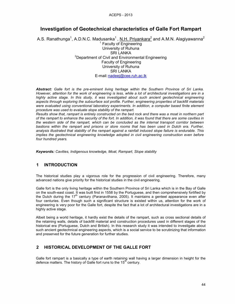
was an earthen structure with palisades covering the northern land side with a rampart and three bastions. They believed that the sea ward side was impregnable and hence did not construct any fortifications on the sea side. The main gate is in the northern stretch of the fort on the land side and is heavily fortified. The Portuguese had built an 18 feet broad moat connecting Kepu ela and Galle harbour to enhance the safety of the fort as shown in Figure 1.
2.2 Dutch Period (1640 – 1796)
When the fort came under the control of Dutch, they considered that an old fortification built by the Portuguese is unsafe as they were made of earth and palisades.
Hence, the Dutch decided to fully encircle the entire peninsula by building an impregnable fortification as defence against other colonial agencies in the region. They built 14 bastions using coral and granite
Figure 1 Plan of the Fortress of Galle in 1790’s (Paranavithana, 2005)
A
B
D
E
F
G I
H
J
K
L
M
N
O
P
Q
C
R
Current Galle
International Cricket
Stadium
Current Galle Bus
Stand
LEGEND A – Sun Bastion
B – Moon Bastion
C – Clock Tower
D – Star Bastion
E – Light House& Point
Utrecht Bastion
F – Aswrt Bastion
G – Moat
H – Draw Bridge
I – Kepu ela
J – Aeolus Bastion
K – Clippenburg Bastion
L – Neptune Bastion
M – Triton Bastion
N – Flagrock Bastion
O – Aurora Bastion
P – Akersloot Bastion
Q – Commandment Bastion
R – Fishmark Bastion
S – Galle Harbour
S
ACEPS - 2013
46
stones over an area of 52 hectares (Figure 1). The rampart is 10 palms thick running along the bedrock and, the bulwarks and the breastwork are entirely built of stone and mortar. Further (Paranavithana, 2005) stated that Dutch have broadened the moat to 30 feet during the latter half of the 18
th century.
Figure 1 illustrates the plan of the Galle fort with its surroundings as it was during the survey in the year 1790 (Paranavithana, 2005).
2.3 British Period (1796 – 1948)
During British period no major alterations were done to the Fortress itself, other than the construction of the entrance on the esplanade side.
3 METHODOLOGY
The research study was conducted in three separate stages. Subsurface soil profile of the rampart was evaluated at first stage. Then engineering properties of the materials within and surrounding the rampart were determined using laboratory experiments. Finally, slope stability of the rampart under different rainfall intensities was evaluated.
3.1 Evaluation of subsurface soil profile
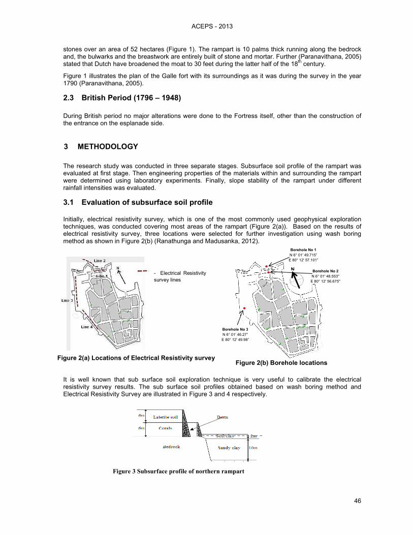
Initially, electrical resistivity survey, which is one of the most commonly used geophysical exploration techniques, was conducted covering most areas of the rampart (Figure 2(a)). Based on the results of electrical resistivity survey, three locations were selected for further investigation using wash boring method as shown in Figure 2(b) (Ranathunga and Madusanka, 2012).
It is well known that sub surface soil exploration technique is very useful to calibrate the electrical resistivity survey results. The sub surface soil profiles obtained based on wash boring method and Electrical Resistivity Survey are illustrated in Figure 3 and 4 respectively.
Borehole No 3
N 6° 01' 46.27”
E 80° 12' 49.98”
Borehole No 1
N 6° 01' 49.715”
E 80° 12' 57.101”
N Borehole No 2
N 6° 01' 48.553''
E 80° 12' 56.675''
Figure 2(b) Borehole locations
- Electrical Resistivity
survey lines
Figure 2(a) Locations of Electrical Resistivity survey
Figure 3 Subsurface profile of northern rampart
ACEPS - 2013
47
Distance (m)
Case (a) – Built by Portuguese
Corals
Bedrock
Weathered rock
Ele
vation (
m)
Soft clay
Sandy clay
3.2 Determination of material properties
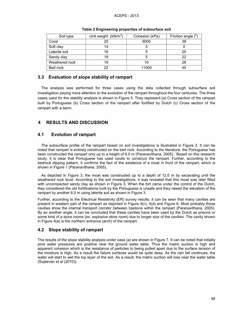
After the field investigation, engineering properties of subsurface soil, which were collected during subsurface soil exploration, were determined using laboratory experiments and results are summarized in Table 1.
(d) Electrical Resistivity Line 4
3
Cavity
(c) Electrical Resistivity Line 3
1 2
Cavities
(b) Electrical Resistivity Line 2 (a) Electrical Resistivity Line 1
Cavity
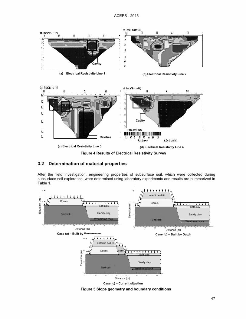
Figure 4 Results of Electrical Resistivity Survey
Distance (m)
Ele
vation (
m) Corals
Bedrock Weathered rock
Sandy clay
Soft clay
Lateritic soil fill
Berm
Case (c) – Current situation
Case (b) – Built by Dutch
Ele
vation (
m)
Distance (m)
Corals
Weathered rock
Sandy clay
Bedrock
Soft clay
Lateritic soil fill
Figure 5 Slope geometry and boundary conditions
ACEPS - 2013
48
Table 2 Engineering properties of subsurface soil
Soil type Unit weight (kN/m3) Cohesion (kPa) Friction angle (
0)
Coral 20 6000 38
Soft clay 14 5 0
Laterite soil 16 5 20
Sandy clay 18 5 22
Weathered rock 19 10 28
Bed rock 22 11000 45
3.3 Evaluation of slope stability of rampart
The analysis was performed for three cases using the data collected through subsurface soil
investigation paying more attention to the evolution of the rampart throughout the four centuries. The three
cases used for the stability analysis is shown in Figure 5. They represent (a) Cross section of the rampart
built by Portuguese (b) Cross section of the rampart after fortified by Dutch (c) Cross section of the
rampart with a berm.
4 RESULTS AND DISCUSSION
4.1 Evolution of rampart
The subsurface profile of the rampart based on soil investigations is illustrated in Figure 3. It can be noted that rampart is entirely constructed on the bed rock. According to the literature, the Portuguese has been constructed the rampart only up to a height of 6.0 m (Paranavithana, 2005). Based on this research study, it is clear that Portuguese has used corals to construct the rampart. Further, according to the bedrock dipping pattern, it confirms the fact of the existence of a moat in front of the rampart, which is shown in Figure 1 (Paranavithana, 2005).
As depicted in Figure 3, the moat was constructed up to a depth of 12.0 m by excavating until the weathered rock level. According to the soil investigations, it was revealed that this moat was later filled with uncompacted sandy clay as shown in Figure 3. When the fort came under the control of the Dutch, they considered the old fortifications built by the Portuguese is unsafe and they raised the elevation of the rampart by another 6.0 m using laterite soil as shown in Figure 3.
Further, according to the Electrical Resistivity (ER) survey results, it can be seen that many cavities are present in western part of the rampart as depicted in Figure 4(c), 4(d) and Figure 6. Most probably these cavities show the internal transport corridor between bastions within the rampart (Paranavithana, 2005). By an another angle, it can be concluded that these cavities have been used by the Dutch as prisons or some kind of a store rooms (ex. explosive store room) due to longer size of the cavities. The cavity shown in Figure 4(a) is the northern entrance (arch) of the rampart.
4.2 Slope stability of rampart
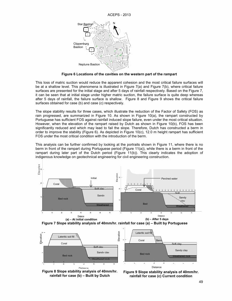
The results of the slope stability analysis under case (a) are shown in Figure 7. It can be noted that initially pore water pressures are positive near the ground water table. Thus the matric suction is high and apparent cohesion which is the resistance of particles to being pulled apart due to the surface tension of the moisture is high. As a result the failure surfaces would be quite deep. As the rain fall continues, the water will start to wet the top layer of the soil. As a result, the matric suction will loss near the water table (Sujeevan et al (2010)).
ACEPS - 2013
49
Star Bastion N
Clippenburg Bastion
Neptune Bastion
Figure 6 Locations of the cavities on the western part of the rampart
This loss of matric suction would reduce the apparent cohesion and the most critical failure surfaces will be at a shallow level. This phenomena is illustrated in Figure 7(a) and Figure 7(b), where critical failure surfaces are presented for the initial stage and after 5 days of rainfall respectively. Based on the Figure 7, it can be seen that at initial stage under higher matric suction, the failure surface is quite deep whereas after 5 days of rainfall, the failure surface is shallow. Figure 8 and Figure 9 shows the critical failure surfaces obtained for case (b) and case (c) respectively.
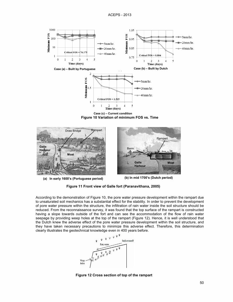
The slope stability results for three cases, which illustrate the reduction of the Factor of Safety (FOS) as rain progressed, are summarized in Figure 10. As shown in Figure 10(a), the rampart constructed by Portuguese has sufficient FOS against rainfall induced slope failure, even under the most critical situation. However, when the elevation of the rampart raised by Dutch as shown in Figure 10(b), FOS has been significantly reduced and which may lead to fail the slope. Therefore, Dutch has constructed a berm in order to improve the stability (Figure 6). As depicted in Figure 10(c), 12.0 m height rampart has sufficient FOS under the most critical condition with the introduction of the berm.
This analysis can be further confirmed by looking at the portraits shown in Figure 11, where there is no berm in front of the rampart during Portuguese period (Figure 11(a)), while there is a berm in front of the rampart during later part of the Dutch period (Figure 11(b)). This clearly indicates the adoption of indigenous knowledge on geotechnical engineering for civil engineering construction.
(a) – At initial condition Distance
0 10 20 30 40 50 60 70
Ele
va
tion
0
10
20
30
Coral
Bed rock
Sandy
Soft clay
Initial
Weathered
(b) – After 5 days
Distance
0 10 20 30 40 50 60 70
Ele
vatio
n
0
10
20
30
Coral
Sandy
clay
Weathered Bed
Perched water
Soft
Coral
Lateritic soil fill
Sandy clay
Weathered rock
Soft clay
Ele
vation
Distance
Bed rock
Figure 8 Slope stability analysis of 40mm/hr.
rainfall for case (b) – Built by Dutch
Coral
Lateritic soil fill
Sandy clay
Weathered rock
Soft clay
Ele
vation
Distance
Bed rock
Berm
Figure 9 Slope stability analysis of 40mm/hr. rainfall for case (c) Current condition
Figure 7 Slope stability analysis of 40mm/hr. rainfall for case (a) – Built by Portuguese
ACEPS - 2013
50
Case (a) – Built by Portuguese Case (b) – Built by Dutch
Case (c) – Current condition
Figure 10 Variation of minimum FOS vs. Time
According to the demonstration of Figure 10, the pore water pressure development within the rampart due to unsaturated soil mechanics has a substantial effect for the stability. In order to prevent the development of pore water pressure within the structure, the infiltration of rain water inside the soil structure should be reduced. From the reconnaissance survey, it was found that the top surface of the rampart is constructed having a slope towards outside of the fort and can see the accommodation of the flow of rain water seepage by providing weep holes at the top of the rampart (Figure 12). Hence, it is well understood that the Dutch knew the adverse effect of the pore water pressure development within the soil structure, and they have taken necessary precautions to minimize this adverse effect. Therefore, this determination clearly illustrates the geotechnical knowledge even in 400 years before.
Moat Galle
Harbour
Rampart
Berm
(b) In mid 1700’s (Dutch period) (a) In early 1600’s (Portuguese period)
Galle
Harbour
Draw Bridge Rampart
Moat
Figure 11 Front view of Galle fort (Paranavithana, 2005)
Figure 12 Cross section of top of the rampart
ACEPS - 2013
51
5 CONCLUSIONS
Based on soil investigations, it was revealed that the rampart is entirely constructed on the bed rock and it avoids the undesirable settlement of this huge and heavy structure with time. Northern rampart is the oldest part of the rampart which has been built by all the three nations Portuguese, Dutch and British consequently while other parts of the rampart have been fortified by Dutch and British (Paranavithana, 2005). According to the borehole investigations, it can be concluded that Portuguese used fractured corals to construct the northern rampart up to a height of 6.0 m, and which is founded on the bed rock. Further rubble and coral masonry structure were used as the facing elements in order to protect the structure by erosion. According to the soil investigations, the bed rock dipping pattern at the northern entrance of the rampart confirms the fact of the existence of the moat in front of the rampart which was constructed by Portuguese and afterwards closed down by the British.
Further, according to the electrical resistivity survey results, it can be seen that many cavities are present in western part of the rampart which can be concluded as internal transport corridors between bastions and prisons or store rooms within the western side of the rampart which has been used by Dutch.
The Portuguese constructed the rampart using corals, which has sufficient FOS against rainfall induced slope failure. With the fortification done to the rampart by Dutch, the FOS has been significantly reduced. Then, they use a berm to improve the stability of the rampart indicating their knowledge on geotechnical engineering. By providing weep holes and constructing a sloping top surface Dutch have reduce the rainfall infiltration to the soil structure. It decreases the development of pore water pressure within the soil structure while increasing the slope stability.
Hence, it clearly depicts that the Dutch was familiar with those geotechnical engineering concepts at a time where the geotechnical principles were not even developed.
6 ACKNOWLEDGMENT
This study was supported by the research grant received under the transforming University of Ruhuna into International Level. Special gratitude is conveyed to National Building Research Organization (NBRO) for the assistance in conducting the Electrical Resistivity (ER) Survey.
7 REFERENCES
Paranavithana, K. D. (2005), Galle fort; The Heritage City, Ruhunu Tourist Bureau of the Southern Provincial Council, Galle, Sri Lanka, pp. 7-26. ICOMOS. (1988), International Council On Monuments and Sites, Advisory Body Evaluation, pp. 1-5. Ranathunga, A.S. and Madusanka, A.D.N.C. (2012), Investigation of indigenous knowledge adopted in construction of a colonial fort: A case study on Galle fort with respect to geotechnical engineering, BSc Engineering Final year project, University of Ruhuna. Sujeevan, V., Karunaratna, W.W.N. and Rajeev, T. (2010), Rain induced slope failures in unsaturated residual soils, Proceedings of Project Day, Sri Lanka Geotechnical Society, pp. 5-8.