Embed Size (px)
Citation preview
ORIGINAL PAPER
Investigation of sea level anomalies related with NAOalong the west coasts of Turkey and their consistency with seasurface temperature trends
Mustafa Dogan & H. Kerem Cigizoglu & D. Ugur Sanli &Asli Ulke
Received: 27 February 2014 /Accepted: 25 July 2014# Springer-Verlag Wien 2014
Abstract It is well-known that North Atlantic Oscillation(NAO), which is one of the large-scaled climate modes effec-tive in the Northern Hemisphere, has a considerable affect onthe water resources and climatic indicators especially in theMediterranean basin. In recent years, also crucial studiesabout the sea level rise in relation to climate change have beenaccelerated. Turkey has about 20 modernized tide gauge sta-tions equipped with permanent GPS receivers and targets tocontribute to global sea level rise studies in the future. The aimof this study is to find out the effects of North AtlanticOscillation on the national shores using the data of four tide-gauge stations located on the Aegean and Mediterraneancoasts of Turkey. Implications from these four tide gaugeswould motivate researches to take into account the effect ofNAO in calculating the true sea level rise at the nationalcoasts. While studying the sea level changes, vertical crustalmovement has been observed using the data of tide gaugeGPS stations, and this situation has been taken into consider-ation in the evaluation of sea levels. Besides, in order toinvestigate the influences of thermal expansion on sea levels,sea surface temperature data of the meteorology stations nearthe tide gauges have been evaluated. The homogeneity of the
data sets was analyzed using four statistical tests. As a result,all of the meteorology stations’ temperature series and tidegauges’ data are subjected to trend detection after the homo-geneity analysis. Eventually, the effects of North AtlanticOscillation on both sea levels and sea surface temperatureshave been introduced. The study results indicate highcorrelation between North Atlantic Oscillation and the sealevel and sea surface temperature events. It is seen thatthe linear correlation between the sea level trends of theconsidered stations and the sea surface temperature data ofthe related meteorology stations is considerably significant.
1 Introduction
Increase in the atmospheric temperature has a direct effect onthe water of ocean by causing a rise in the water temperature,melting of glaciers, and a change of global sea levels. Also, arise in sea level would inundate wetlands and lowlands, ac-celerate coastal erosion, exacerbate flooding, threaten coastalstructures, and increase the salinity of rivers and aquifers.Hence, global sea level trends have generally been assumedas a good indicator for changes in the climate. Because of this,many researchers focused on the estimation of sea level rise attidal stations around the world, after 1980s. Revelle (1983)noted that the best indicator of the climate change is thewarming and resulting expansion of sea water which couldraise sea level from 30 to 50 cm, in the twenty-first century.On the other hand, Titus et al. (1991) declared that during thepast century, worldwide sea level has risen from 10 to 25 cm,much of which has been attributed to the global warming. Inrecent years, crucial studies about sea level rises depending onclimate change have been accelerated. However, most of thesestudies have indicated that the spatial distribution of sea levelpresents regional differences. For example, in South China,the results show that the sea level has risen at a rate of
M. Dogan (*)Department of Civil Engineering, Dokuz Eylul University,35160 Buca, Izmir, Turkeye-mail: [email protected]
H. K. CigizogluDepartment of Civil Engineering, Istanbul Technical University,34469 Maslak, Istanbul, Turkey
D. U. SanliDepartment of Geomatic Engineering, Yildiz Technical University,34220 Esenler, Istanbul, Turkey
A. UlkeDepartment of Civil Engineering, Ondokuz Mayis University,55139 Samsun, Turkey
Theor Appl ClimatolDOI 10.1007/s00704-014-1247-3
11.3 mm/year during 1993–2000 and fallen at a rate of11.8 mm/year during 2001–2005 (Cheng and Qi 2007).Nonetheless, it is presented by Holgate and Woodworth(2004) that the rate of the sea level rise around the globalcoastlines was significantly in excess of the global averageover the period 1993–2002 as well. Church et al. (2006)indicated that the average rise at Pacific and Indian Oceansis about 2 mm per year and after the year 1993, this rise wasabout twice of the one determined before 1970. Church andWhite (2006) also investigated an acceleration in global sealevel rise using tide gauge data at the period 1870–2000. Theirstudy indicates a rapid sea level rise after 1993. Becker et al.(2009) found different trends in sea level records ranging from1.7 to 2.7 mm/year, at four stations in the South of theNetherlands. Despite a relatively small distance between thesestations, they explained this trend differences engaged to somestructures like harbor and pier and also global warming.Hence, a good understanding of the dominant local parame-ters is required to evaluate the sea level changes.
Some researchers desired to know the connection betweenthe sea surface temperature (SST) and sea surface level withthe major large-scale atmospheric forcing like air temperature,surface wind, North Atlantic Oscillation (NAO), and El Nino-Southern Oscillation (ENSO) in all over the world’s seacoasts. There are some indications of relation in South ChinaSea, European coasts, Atlantic and Black Sea between theseatmospheric circulations and sea surface temperature andhence sea surface level. For example, in the South ChinaSea, it is enounced that sea surface temperatures are closelyrelated to ENSO because of the geographical location (Wanget al. 2000, 2006; Rong et al. 2007). Rong et al. (2007)declared that sea level anomalies are negative during El-Nino years and positive during La-Nina years in the SouthChina Sea. Hence during El-Nino years, the whole sea levelfalls and during La-Nina years it rises. Tsimplis and Shaw(2008) declared that NAO and Mediterranean OscillationIndex are significantly relevant with sea-level variabilityaround Europe coasts and they found this correlationpositive for the Northern European coasts and negative forthe Mediterranean coasts. Aldeanueva et al. (2008) studied14 years of altimetry data of different basins of theMediterranean Sea. They found negative trends like −10±0.8 mm per year in the Ionian basin. They also detected alow but significant correlation between sea level and NOAindex in the Levantine and Balearic basins. Aravena et al.(2009) provided the important influence of NAO on climaticfactors and estuarine water temperature on the Basque coast,northeast Atlantic.
The effects of the above atmospheric phenomena in theNorth Atlantic appear as “regime shifts” in SSTs and sealevel trends. They cause long-term variations in the climatesystem with decadal or interdecadal time scales. The phasereversals of such long-term variations appear like a step
function in SST and sea level time series, and these rever-sals are also called “climate jump.” Yasunaka and Hawana(2002) describe the regime shift as “an abrupt transitionfrom one quasi-steady climatic state to another and thistransition period is much shorter than the length of theindividual epochs of each climatic state.” In their study,using winter SST field in the Northern Hemisphere, theydetected six regime shifts related to various atmosphericand oceanic modes of variability from the 1910s to the1990s. Swanson and Tsonis (2009) studied the regimeshifts in the Northern Hemisphere and noted the occurrenceof a new shift in 2001/2002. Dippner et al. (2010) ascribethe regime shifts, occurring for the period 1978–2005, tobiological regime shifts which are used to describe thechanges in abundance and composition of plankton and fishand propagate through several trophic levels. They detectedtwo regime shifts; one in 1989/1990 and one in 2001/2002.
There are also some indications of relation between NAO,ENSO, and sea surface temperature in the Black Sea (Oğuz2005; Ginzburg, et al. 2004). First of all, Oğuz (2005) showedin the 1960–1980 period that there were a negative phase ofNAO index and a positive one in 1980–1995 in the Black Sea.Later, Oğuz et al. (2006) showed that the NAO teleconnectionto the Black Sea is opposite in the eastern North Atlantic.Finally, Kazmin and Zatsepin (2007) investigated the long-term winter mean sea surface temperature variability in theBlack Sea in the period 1950–2005 and its association withNAO index.
In all of these studies, vertical land movements makeproblematic the determination of sea level changes from tidegauges stations. To guarantee the quality of the measurementsfrom individual gauges and of the network as a whole, modernmeasurement instruments like global positioning system(GPS) are required (Church et al. 2006). These GPS measure-ments are essential for determining vertical land movementsand real sea level determination (Unnikrishnan and Shankar2007). There are more than 20 years of data in some coasts allover the world.
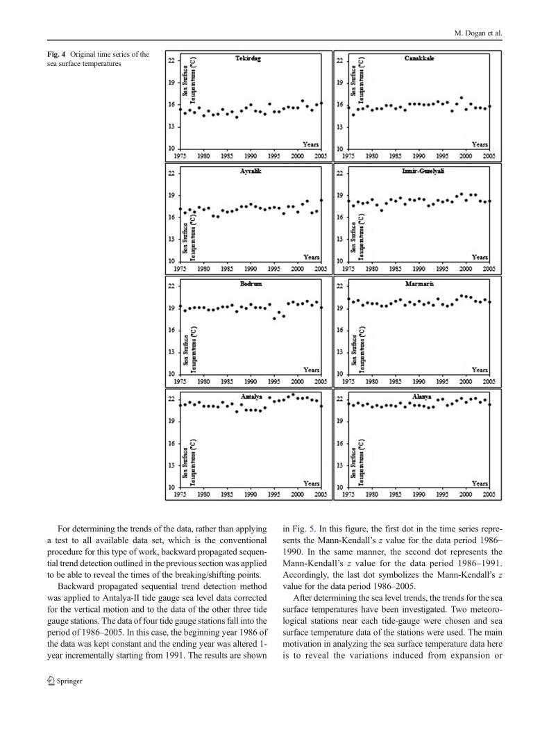
The researchers in Turkey put effort to contribute to theregional and global sea level rise studies using the data of tidegauges and GPS stations scattered around the national coasts(Yildiz et al. 2013). From that point of view, it is important toreveal various influences that might affect the actual sea levelrise and hence the global estimations. In the presented study,the data of four tide-gauge and GPS stations located onAegean and Mediterranean shores of Turkey were used.Besides, sea water temperature (SST) data of the meteorologystations found near the abovementioned stations were evalu-ated. While evaluating the data of the tide gauge stations,vertical crustal movement trends obtained through the GPSdata were taken into account. The effects of North AtlanticOscillation indicator and sea water temperature changes onsea levels were put forward.
M. Dogan et al.
2 Data and methods
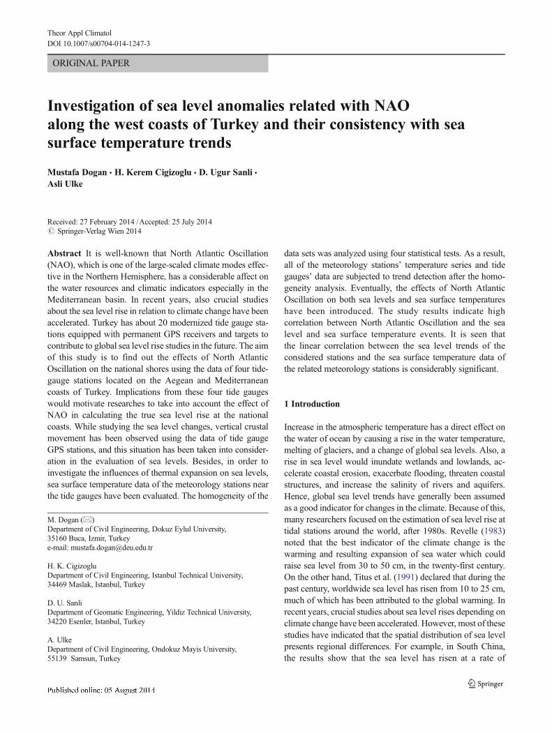
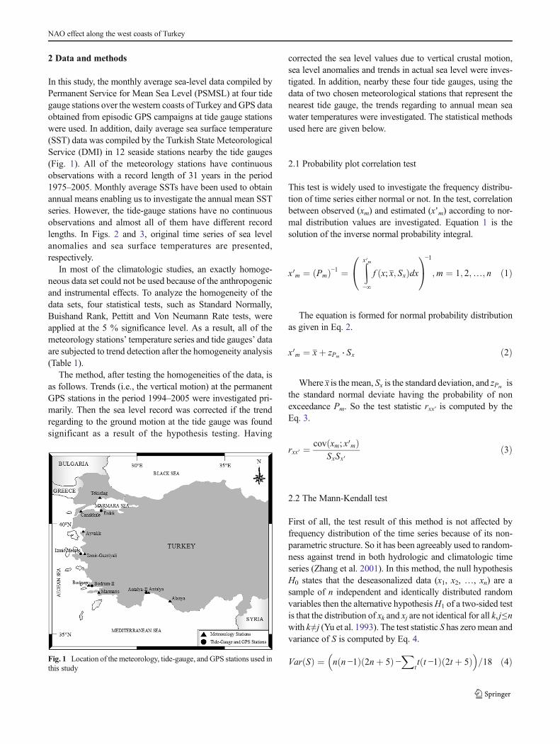
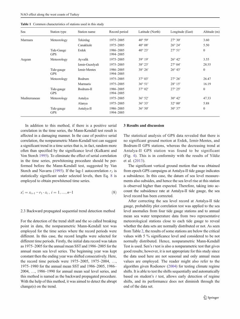
In this study, the monthly average sea-level data compiled byPermanent Service for Mean Sea Level (PSMSL) at four tidegauge stations over the western coasts of Turkey and GPS dataobtained from episodic GPS campaigns at tide gauge stationswere used. In addition, daily average sea surface temperature(SST) data was compiled by the Turkish State MeteorologicalService (DMI) in 12 seaside stations nearby the tide gauges(Fig. 1). All of the meteorology stations have continuousobservations with a record length of 31 years in the period1975–2005. Monthly average SSTs have been used to obtainannual means enabling us to investigate the annual mean SSTseries. However, the tide-gauge stations have no continuousobservations and almost all of them have different recordlengths. In Figs. 2 and 3, original time series of sea levelanomalies and sea surface temperatures are presented,respectively.
In most of the climatologic studies, an exactly homoge-neous data set could not be used because of the anthropogenicand instrumental effects. To analyze the homogeneity of thedata sets, four statistical tests, such as Standard Normally,Buishand Rank, Pettitt and Von Neumann Rate tests, wereapplied at the 5 % significance level. As a result, all of themeteorology stations’ temperature series and tide gauges’ dataare subjected to trend detection after the homogeneity analysis(Table 1).
The method, after testing the homogeneities of the data, isas follows. Trends (i.e., the vertical motion) at the permanentGPS stations in the period 1994–2005 were investigated pri-marily. Then the sea level record was corrected if the trendregarding to the ground motion at the tide gauge was foundsignificant as a result of the hypothesis testing. Having
corrected the sea level values due to vertical crustal motion,sea level anomalies and trends in actual sea level were inves-tigated. In addition, nearby these four tide gauges, using thedata of two chosen meteorological stations that represent thenearest tide gauge, the trends regarding to annual mean seawater temperatures were investigated. The statistical methodsused here are given below.
2.1 Probability plot correlation test
This test is widely used to investigate the frequency distribu-tion of time series either normal or not. In the test, correlationbetween observed (xm) and estimated (x 'm) according to nor-mal distribution values are investigated. Equation 1 is thesolution of the inverse normal probability integral.
x0m ¼ Pmð Þ−1 ¼Zx 0m−∞
f x; x; Sxð Þdx0@
1A−1
;m ¼ 1; 2;…; n ð1Þ
The equation is formed for normal probability distributionas given in Eq. 2.
x0m ¼ xþ zPm ⋅ Sx ð2Þ
Where x is the mean, Sx is the standard deviation, and zPm isthe standard normal deviate having the probability of nonexceedance Pm. So the test statistic rxx ' is computed by theEq. 3.
rxx 0 ¼ cov xm; x0mð ÞSxSx 0
ð3Þ
2.2 The Mann-Kendall test
First of all, the test result of this method is not affected byfrequency distribution of the time series because of its non-parametric structure. So it has been agreeably used to random-ness against trend in both hydrologic and climatologic timeseries (Zhang et al. 2001). In this method, the null hypothesisH0 states that the deseasonalized data (x1, x2, …, xn) are asample of n independent and identically distributed randomvariables then the alternative hypothesisH1 of a two-sided testis that the distribution of xk and xj are not identical for all k, j≤nwith k≠j (Yu et al. 1993). The test statistic S has zeromean andvariance of S is computed by Eq. 4.
Var Sð Þ ¼ n n −1ð Þ 2nþ 5ð Þ −X
tt t −1ð Þ 2t þ 5ð Þ
� �=18 ð4ÞFig. 1 Location of the meteorology, tide-gauge, and GPS stations used in
this study
NAO effect along the west coasts of Turkey
Where t is the extent of any given tie and ∑t denotes thesummation over all ties. Then the asymptotically normal teststatistic S is computed through Eqs. 5 and 6.
S ¼Xn−1k¼1
Xj¼kþ1
n
sgn x j − xk� � ð5Þ
sgn x j − xk� � ¼
þ1 ; x j − xk� �
> 00 ; x j − xk
� � ¼ 0− 1 ; x j − xk
� �< 0
8<:
9=; ð6Þ
If the length of time series n is greater than 10, the standardvariable z is calculated by the Eq. 7 (Douglas et al. 2000). If│z│>zα/2, at the significance level of α, then a significanttrend exists in the time series and sign of z indicates the trenddirection.
z ¼
S − 1ffiffiffiffiffiffiffiffiffiffiffiffiffiffiVar Sð Þp ; S > 0
0 ; S ¼ 0S þ 1ffiffiffiffiffiffiffiffiffiffiffiffiffiffiVar Sð Þp ; S < 0
8>>>><>>>>:
9>>>>=>>>>;
ð7Þ
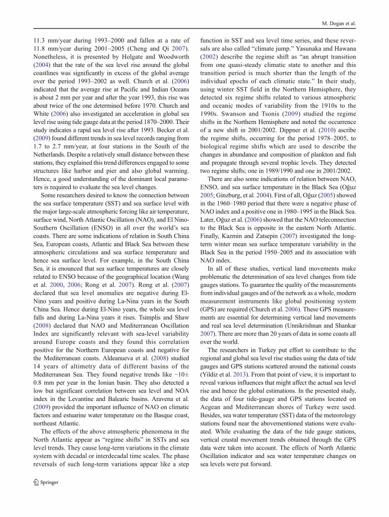
Fig. 2 Vertical ground motionvalues obtained from epoch GPScampaigns nearby the same tidegauges
Fig. 3 Original time series of thesea level anomalies
M. Dogan et al.
In addition to this method, if there is a positive serialcorrelation in the time series, the Mann-Kendall test result isaffected in a damaging manner. In the case of positive serialcorrelation, the nonparametric Mann-Kendall test can suggesta significant trend in a time series that is, in fact, randommoreoften than specified by the significance level (Kulkarni andVon Storch 1995). To eliminate the effect of serial correlationin the time series, prewhitening procedure should be per-formed before the Mann-Kendall test, suggested by VanStorch and Navarra (1995). If the lag-1 autocorrelation r1 isstatistically significant under selected levels, then Eq. 8 isemployed to obtain prewhitened time series.
x0i ¼ xiþ1 − r1 ⋅ xi ; i ¼ 1;…; n−1 ð8Þ
2.3 Backward propagated sequential trend detection method
For the detection of the trend shift and the so called breakingpoint in data, the nonparametric Mann-Kendall test wasemployed for the time series where the record periods weredifferent. In this case, the record lengths were selected fordifferent time periods. Firstly, the initial data record was takenas 1975–2005 for the annual mean SSTand 1986–2005 for theannual mean sea level series. The beginning year was keptconstant then the ending year was shifted consecutively. Here,the record time periods were 1975–2005, 1975–2004, …,1975–1980 for the annual mean SST and 1986–2005, 1986–2004, …, 1986–1990 for annual mean seal level series, andthis method is named as the backward propagated procedure.With the help of this method, it was aimed to detect the abruptchange(s) on the trend.
3 Results and discussion
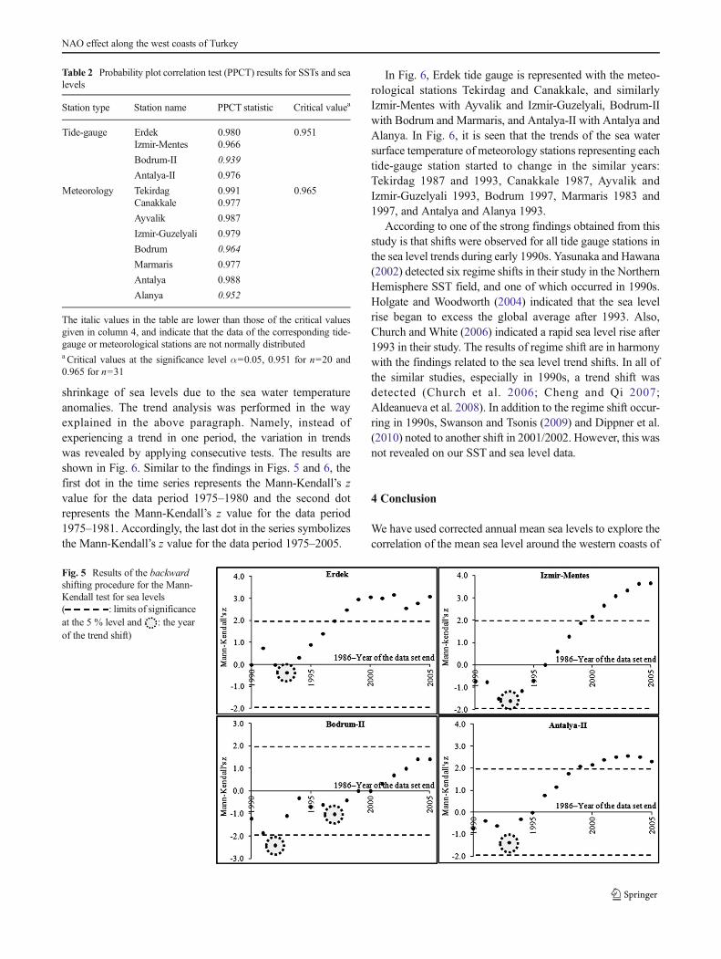
The statistical analysis of GPS data revealed that there isno significant ground motion at Erdek, Izmir-Mentes, andBodrum-II GPS stations, whereas the decreasing trend atAntalya-II GPS station was found to be significant(Fig. 4). This is in conformity with the results of Yildizet al. (2013).
The significant vertical ground motion that was obtainedfrom epoch GPS campaigns at Antalya-II tide gauge indicatesa subsidence. In this case, the datum of sea level measure-ments also subsides, and hence the sea level rise at this stationis observed higher than expected. Therefore, taking into ac-count the subsidence rate at Antalya-II tide gauge, the sealevel record has been corrected.
After correcting the sea level record at Antalya-II tidegauge, probability plot correlation test was applied to the sealevel anomalies from four tide gauge stations and to annualmean sea water temperature data from two representativemeteorological stations close to each tide gauge to revealwhether the data sets are normally distributed or not. As seenfrom Table 2, the results of some stations are below the criticalvalues with 5 % significance level and considered to be notnormally distributed. Hence, nonparametric Mann-KendallTest is used. Sen’s t test is also a nonparametric test that givesgood results; however, it is not appropriate for this study sincethe data used here are not seasonal and only annual meanvalues are employed. The reader might also refer to thealgorithm given Rodionov (2004) for testing climate regimeshifts. It is able to test the shifts sequentially and automaticallybased on student’s t test, allows early detection of regimeshifts, and its performance does not diminish through theend of the data set.
Table 1 Common characteristics of stations used in this study
Sea Station type Station name Record period Latitude (North) Longitude (East) Altitude (m)
Marmara Meteorology Tekirdag 1975–2005 40° 59′ 27° 30′ 3.60
Canakkale 1975–2005 40° 08′ 26° 24′ 5.50
Tide-Gauge Erdek 1986–2005 40° 23′ 27° 51′ 0GPS 1994–2005
Aegean Meteorology Ayvalik 1975–2005 39° 19′ 26° 42′ 3.55
Izmir-Guzelyali 1975–2005 38° 23′ 27° 04′ 28.55
Tide-gauge Izmir-Mentes 1986–2005 38° 26′ 26° 43′ 0GPS 1994–2005
Meteorology Bodrum 1975–2005 37° 03′ 27° 26′ 26.47
Marmaris 1975–2005 36° 51′ 28° 15′ 16.19
Tide-gauge Bodrum-II 1986–2005 37° 02′ 27° 25′ 0GPS 1994–2005
Mediterranean Meteorology Antalya 1975–2005 36° 52′ 30° 42′ 47.33
Alanya 1975–2005 36° 33′ 32° 00′ 5.88
Tide-gauge Antalya-II 1986–2005 36° 50′ 30° 37′ 0GPS 1994–2005
NAO effect along the west coasts of Turkey
For determining the trends of the data, rather than applyinga test to all available data set, which is the conventionalprocedure for this type of work, backward propagated sequen-tial trend detection outlined in the previous section was appliedto be able to reveal the times of the breaking/shifting points.
Backward propagated sequential trend detection methodwas applied to Antalya-II tide gauge sea level data correctedfor the vertical motion and to the data of the other three tidegauge stations. The data of four tide gauge stations fall into theperiod of 1986–2005. In this case, the beginning year 1986 ofthe data was kept constant and the ending year was altered 1-year incrementally starting from 1991. The results are shown
in Fig. 5. In this figure, the first dot in the time series repre-sents the Mann-Kendall’s z value for the data period 1986–1990. In the same manner, the second dot represents theMann-Kendall’s z value for the data period 1986–1991.Accordingly, the last dot symbolizes the Mann-Kendall’s zvalue for the data period 1986–2005.
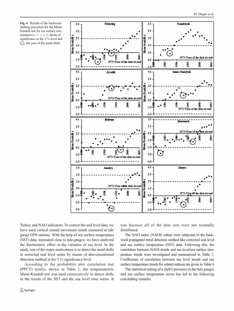
After determining the sea level trends, the trends for the seasurface temperatures have been investigated. Two meteoro-logical stations near each tide-gauge were chosen and seasurface temperature data of the stations were used. The mainmotivation in analyzing the sea surface temperature data hereis to reveal the variations induced from expansion or
Fig. 4 Original time series of thesea surface temperatures
M. Dogan et al.
shrinkage of sea levels due to the sea water temperatureanomalies. The trend analysis was performed in the wayexplained in the above paragraph. Namely, instead ofexperiencing a trend in one period, the variation in trendswas revealed by applying consecutive tests. The results areshown in Fig. 6. Similar to the findings in Figs. 5 and 6, thefirst dot in the time series represents the Mann-Kendall’s zvalue for the data period 1975–1980 and the second dotrepresents the Mann-Kendall’s z value for the data period1975–1981. Accordingly, the last dot in the series symbolizesthe Mann-Kendall’s z value for the data period 1975–2005.
In Fig. 6, Erdek tide gauge is represented with the meteo-rological stations Tekirdag and Canakkale, and similarlyIzmir-Mentes with Ayvalik and Izmir-Guzelyali, Bodrum-IIwith Bodrum and Marmaris, and Antalya-II with Antalya andAlanya. In Fig. 6, it is seen that the trends of the sea watersurface temperature of meteorology stations representing eachtide-gauge station started to change in the similar years:Tekirdag 1987 and 1993, Canakkale 1987, Ayvalik andIzmir-Guzelyali 1993, Bodrum 1997, Marmaris 1983 and1997, and Antalya and Alanya 1993.
According to one of the strong findings obtained from thisstudy is that shifts were observed for all tide gauge stations inthe sea level trends during early 1990s. Yasunaka and Hawana(2002) detected six regime shifts in their study in the NorthernHemisphere SST field, and one of which occurred in 1990s.Holgate and Woodworth (2004) indicated that the sea levelrise began to excess the global average after 1993. Also,Church and White (2006) indicated a rapid sea level rise after1993 in their study. The results of regime shift are in harmonywith the findings related to the sea level trend shifts. In all ofthe similar studies, especially in 1990s, a trend shift wasdetected (Church et al. 2006; Cheng and Qi 2007;Aldeanueva et al. 2008). In addition to the regime shift occur-ring in 1990s, Swanson and Tsonis (2009) and Dippner et al.(2010) noted to another shift in 2001/2002. However, this wasnot revealed on our SST and sea level data.
4 Conclusion
We have used corrected annual mean sea levels to explore thecorrelation of the mean sea level around the western coasts of
Table 2 Probability plot correlation test (PPCT) results for SSTs and sealevels
Station type Station name PPCT statistic Critical valuea
Tide-gauge Erdek 0.980 0.951Izmir-Mentes 0.966
Bodrum-II 0.939
Antalya-II 0.976
Meteorology Tekirdag 0.991 0.965Canakkale 0.977
Ayvalik 0.987
Izmir-Guzelyali 0.979
Bodrum 0.964
Marmaris 0.977
Antalya 0.988
Alanya 0.952
The italic values in the table are lower than those of the critical valuesgiven in column 4, and indicate that the data of the corresponding tide-gauge or meteorological stations are not normally distributeda Critical values at the significance level α=0.05, 0.951 for n=20 and0.965 for n=31
Fig. 5 Results of the backwardshifting procedure for the Mann-Kendall test for sea levels( : limits of significanceat the 5 % level and : the yearof the trend shift)
NAO effect along the west coasts of Turkey
Turkey and NAO indicators. To correct the seal level data, wehave used vertical crustal movement trends measured at tidegauge GPS stations. With the help of sea surface temperature(SST) data, measured close to tide-gauges, we have analyzedthe thermosteric effect in the variation of sea level. In thestudy, one of the major motivations is to detect the trend shiftsin corrected seal level series by means of abovementioneddetection method at the 5 % significance level.
According to the probability plot correlation test(PPCT) results, shown in Table 2, the nonparametricMann-Kendall test was used consecutively to detect shiftsin the trends of the SST and the sea level time series. It
was because all of the data sets were not normallydistributed.
The NAO index (NAOI) values were subjected to the back-ward propagated trend detection method like corrected seal leveland sea surface temperature (SST) data. Following this, thecorrelation between NAOI trends and sea level/sea surface tem-perature trends were investigated and summarized in Table 3.Coefficients of correlation between sea level trends and seasurface temperature trends for related stations are given in Table 4.
The statistical testing of a shift’s presence in the tide gaugesand sea surface temperature series has led to the followingconcluding remarks.
Fig. 6 Results of the backwardshifting procedure for the Mann-Kendall test for sea surface tem-peratures ( : limits ofsignificance at the 5 % level and
: the year of the trend shift)
M. Dogan et al.
1. Shifts in the sea level trends during early 1990s wereobserved for all the considered tide-gauge stations in thisstudy.
2. For SST trends, shifts were noted at late 1980s in Tekirdagand Canakkale, at early 1990s in Ayvalik, Izmir-Guzelyali, Antalya and Alanya, at late 1990s in Bodrumand Marmaris meteorology stations.
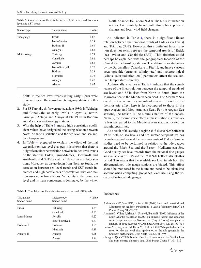
3. With the help of Table 3, mostly high correlation coeffi-cient values have designated the strong relation betweenNorth Atlantic Oscillation and the sea level and sea sur-face temperature.
4. In Table 4, prepared to explain the effect of thermalexpansion on sea level changes, it is shown that there isa significant linear correlation between the sea level trendsof the stations Erdek, İzmir-Mentes, Bodrum-II andAntalya-II, and SST data of the related meteorology sta-tions. Moreover, as we go down from North to South, thecorrelation between sea level trends and SST trends in-creases and high coefficients of correlation with one sta-tion rises up to two stations. Variability in the basin sealevel and its mass component is dominated by the winter
North Atlantic Oscillation (NAO). The NAO influence onsea level is primarily linked with atmospheric pressurechanges and local wind field changes.
As indicated in Table 4, there is a significant linearrelation between the temporal trends of Erdek (sea levels)and Tekirdag (SST). However, this significant linear rela-tion does not exist between the temporal trends of Erdek(sea levels) and Canakkale (SST). This situation couldperhaps be explained with the geographical location of theCanakkale meteorology station. The station is located near-by the Dardanelles (Canakkale in Fig. 1), and hence variousoceanographic (currents, salinity, etc.) and meteorological(winds, solar radiation, etc.) parameters affect the sea sur-face temperatures directly.
Additionally, r values in Table 4 indicate that the signif-icance of the linear relation between the temporal trends ofsea levels and SSTs rises from North to South (from theMarmara Sea to the Mediterranean Sea). The Marmara Seacould be considered as an inland sea and therefore thethermosteric effect here is less compared to those in theopen Aegean and Mediterranean Seas. For the Aegean Seastations, the reason is the sinuous nature of the coasts.Namely, the thermosteric effect at these stations is relative-ly less compared to the Mediterranean stations located onstraight coastlines.
As a result of this study, a regime shift due to NAO effect in1990s both on sea levels and sea surface temperatures hasbeen determined around the western coasts of Turkey. Similarstudies need to be performed in relation to the tide gaugesaround the Black Sea and the Eastern Mediterranean Sea.Good quality sea level records from the national tide gaugesare available as of 1985 and the 1990NAO effect falls into thisperiod. This means that the available sea level trends from theaforementioned tide gauge stations are biased. This effectshould be monitored in the future and need to be taken intoaccount when computing global sea level rise using the re-cords of national tide gauges.
References
Aldeanueva FC, Vera JDR, Lafuente JG (2008) Steric and mass-inducedMediterranean sea level trends from 14 years of altimetry data. GlobPlanet Chang 60:563–575
Aravena G, Villate F, Iriarte A, Uriarte I, Ibanez B (2009) Influence of thenorth Atlantic oscillation (NAO) on climatic factors and estuarinewater temperature on the Basque coast (Bay of Biscay): comparativeanalysis of three seasonal NAO indices. Cont Shelf Res 29:750–758
Becker M, Karpytchev M, Davy M, Doekes K (2009) Impact of a shift inmean on the sea level rise: application to the tide gauges in theSouthern Netherlands. Cont Shelf Res 29:741–749
Cheng X, Qi Y (2007) Trends of sea level variations in the South ChinaSea from merged altimetry data. Glob Planet Chang 57:371–382
Table 3 Correlation coefficients between NAOI trends and both sealevel and SST trends
Station type Station name r value
Tide-gauge Erdek 0.67
Izmir-Mentes 0.58
Bodrum-II 0.68
Antalya-II 0.68
Meteorology Tekirdag 0.79
Canakkale 0.92
Ayvalik 0.83
Izmir-Guzelyali 0.77
Bodrum 0.53
Marmaris 0.76
Antalya 0.47
Alanya 0.67
Table 4 Correlation coefficients between sea level and SST trends
Tide-gauge Meteorology r valueStation name Station name
Erdek Tekirdag 0.84
Canakkale −0.07Izmir-Mentes Ayvalik 0.22
Izmir-Guzelyali 0.87
Bodrum-II Bodrum 0.65
Marmaris 0.88
Antalya-II Antalya 0.98
Alanya 0.94
NAO effect along the west coasts of Turkey

Church JA, White NJ (2006) A 20th century acceleration in global sealevel rise. Geophys Res Lett 33:L01602. doi:10.1029/2005GL024826
Church JA, White NJ, Hunter JR (2006) Sea level rise at tropical Pacificand Indian Oceans Islands. Glob Planet Chang 53:155–168
Dippner JW, Junker K, Kröncke I (2010) Biological regime shifts andchanges in predictability. Geophys Res Lett 37:L01602. doi:10.1029/2010GL045696
Douglas EM, Vogel RM, Kroll CN (2000) Trends in floods and low flowsin the United States: impact of spatial correlation. J Hydrol 240:90–105
Ginzburg AI, Kostianoy AG, Sheremet NA (2004) Seasonal and interan-nual variability of the Black Sea surface temperature as revealedfrom satellite data (1982–2000). J Mar Syst 52:33–50
Holgate SJ, Woodworth PL (2004) Evidence for enhanced sea level riseduring the 1990s. Geophys Res Lett 31:1–4
Kazmin AS, Zatsepin AG (2007) Long term variability of surface tem-perature in the Black Sea, and its connection with the large scaleatmospheric forcing. J Mar Syst 68:293–301
Kulkarni A, Von Storch H (1995) Monte-Carlo experiments on the effectof serial correlation on the Mann-Kendall test of trend.Meterologische Z 4(2):82–85
Oğuz T (2005) Black Sea ecosystem response to climatic variations.Oceanography 18(2):122–133
Oğuz T, Dippner JW, Kaymaz Z (2006) Climatic regulation of the BlackSea hydro-meteorological and ecological properties at interannual-to-decadal time scales. J Mar Syst 60:235–254
Revelle R (1983) Probable future changes in sea-level resulting fromincreased atmospheric carbon dioxide. National Academy Press,Washington, pp 433–449, Changing Climate, 8. Chapter
Rodionov SN (2004) A sequential algorithm for testing climate regimeshifts. Geophys Res Lett 31:L09204. doi:10.1029/2004GL019448
Rong Z, Liu Y, Zong H, Cheng Y (2007) Interannual sea level variabilityin the South China Sea and it response to ENSO. Glob Planet Chang53:257–272
Swanson KL, Tsonis AA (2009) Has the climate recently shifted?Geophys Res Lett 36:L06711. doi:10.1029/2008GL037022
Titus JG, Prk RA, Leathermn SP, Weggel JR, Greene MS, Mausel PW,Brown S, Gaunt G, Trehan M, Yohe G (1991) Greenhouse effectand sea level rise: the cost of holding back the Sea. Coast Manag 19:171–204
TsimplisMN, ShawAGP (2008) The forcing ofmean sea level variabilityaround Europe. Glob Planet Chang 63:196–202
Unnikrishnan AS, Shankar D (2007) Are sea level rise trends along thecoasts of the north Indian Ocean consistent with global estimates?Glob Planet Chang 57:301–307
Van Storch H, Navarra A (1995) Analysis of climate variability-applications of statistical techniques. Springer, New York
Wang W, Wang D, Qi Y (2000) Large scale characteristics of interannualvariability of sea surface temperature in the South China Sea. ActaOceanol Sin 22:8–16
Wang C,WangW,Wang D,Wang Q (2006) Interannual variability of theSouth China Sea associated with El Nino. J Geophys Res 111:C03023. doi:10.1029/2005JC003333
Yasunaka S, Hawana K (2002) Regime shifts found in the NorthernHemisphere SST field. J Meteorol Soc Jpn 80(1):119–135
Yildiz H, Andersen OB, SimavM, Aktug B, Ozdemir S (2013) Estimatesof vertical land motion along the southwestern coasts of Turkeyfrom coastal altimetry and tide gauge data. Adv Space Res 51:1572–1580
Yu YS, Zau S, Whittemore D (1993) Nonparametric trend analysis ofwater quality data of rivers in Kansas. J Hydrol 150:61–80
Zhang X, Harvey KD, Hogg WD, Yuzyk TR (2001) Trends in Canadianstreamflow. Water Resour Res 37(4):987–998
M. Dogan et al.