Embed Size (px)
Citation preview
Iowa DOT GIS Implementation Plan
(Strategic Plan Update)
William G. Schuman GIS Coordinator
Iowa Department of Transportation
Tim Strauss Center for Transportation Research
and Education Reginald R. Souleyrette
Center for Transportation Research and Education
Zachary N. Hans Center for Transportation Research
and Education
May 20, 1998
Iowa DOT GIS Implementation Plan
May 20, 1998 i
Table of Contents Table of Contents ........................................................................................... i 1. Introduction ............................................................................................. 1
1.1 Relation of this Plan to the DOT GIS Strategic Plan ....................................... 1 1.2 Relation of this Plan to Other DOT Information Technology Planning Efforts.............................................................................................................................. 1 1.3 Relation of this Plan to Statewide GIS Coordination Efforts .......................... 2 1.4 Structure of this Plan........................................................................................... 2
1.4.1 Emphasis on GIS Activities and Resources .................................................... 2 1.4.2 Outline of the Implementation Plan ................................................................ 3
2. Current Condition of GIS at the Iowa DOT......................................... 3 2.1 Update on Activities Outlined in the Strategic Plan ......................................... 4 2.2 Progress on Recommendations from the Strategic Plan .................................. 7 2.3 Existing resources ................................................................................................ 7
2.3.1 Organizational Policies/Procedures................................................................. 7 2.3.2 Current General GIS Processes ....................................................................... 7 2.3.3 Personnel ......................................................................................................... 8 2.3.4 GIS Hardware.................................................................................................. 9 2.3.5 GIS Software ................................................................................................... 9 2.3.6 Data ............................................................................................................... 10 2.3.7 Related GIS Technologies............................................................................. 11
2.4 Current Activities............................................................................................... 11 3. Desired Future of GIS at the Iowa DOT............................................. 13
3.1 Goals for GIS at Iowa DOT .............................................................................. 13 3.2 Short-term Plans for Iowa DOT’s GIS ............................................................ 13
3.2.1 Development of GIS Technical and Institutional Architecture..................... 13 3.2.2 Metadata Definition....................................................................................... 16 3.2.3 Improvement of Spatial Data Accuracy........................................................ 16 3.2.4 Location and Linear Referencing System Strategy....................................... 17 3.2.5 GIS Applications ........................................................................................... 17 3.2.6 GIS Training.................................................................................................. 19 3.2.7 Short-term Goal Summary ............................................................................ 19
3.3 Long-term plans for Iowa DOT’s GIS............................................................. 19 3.3.1 Integrated Transportation Management Systems.......................................... 20 3.3.2 Linear Referencing System and Database Implementation .......................... 20 3.3.3 Overweight/Oversize Truck Routing System ............................................... 20 3.3.4 Intelligent Transportation System Support ................................................... 20
4. Implementation Plan............................................................................. 22 4.1 Identification of Necessary Tasks ..................................................................... 22
4.1.1 Define Desired GIS Applications.................................................................. 22 4.1.2 Define Necessary GIS Map Features ............................................................ 22 4.1.3 Define GIS System Architecture................................................................... 23 4.1.4 Define GIS Resource and Training Needs .................................................... 23 4.1.5 Design GIS Maintenance Processes.............................................................. 27 4.1.6 Design Database............................................................................................ 28
Iowa DOT GIS Implementation Plan
May 20, 1998 ii
4.1.7 Define GIS Information and Marketing Strategy.......................................... 29 4.1.8 Design and Implementation of Linear Referencing System ......................... 30 4.1.9 Plan the Integration of GIS Related Applications......................................... 31 4.1.10 Design and Build GIS/ITS Applications....................................................... 31
4.2 On-going Tasks................................................................................................... 32 4.3 GIS Software Standards.................................................................................... 32
4.3.1 Desktop GIS Software................................................................................... 32 4.3.2 GIS Maintenance Software ........................................................................... 33 4.3.3 Relational Database Management System Software..................................... 33
4.4 GIS Hardware Standards ................................................................................. 33 4.5 Data Distribution ............................................................................................... 33 4.6 Organization of GIS Budgets............................................................................ 34 4.7 Implementation Summary and Timeline......................................................... 34
5 Conclusion.............................................................................................. 36 5.1 Implications for the Five Components of GIS................................................. 36
5.1.1 Organizational Policies/Procedures............................................................... 36 5.1.2 Personnel ....................................................................................................... 36 5.1.3 Data ............................................................................................................... 37 5.1.4 Hardware ....................................................................................................... 37 5.1.5 Software ........................................................................................................ 38
5.2 Implementation Plan Usage .............................................................................. 38 5.3 Implementation Plan Cost................................................................................. 38
5.3.1 Staff Costs ..................................................................................................... 38 5.3.2 Staff Training ................................................................................................ 38 5.3.3 Hardware Costs ............................................................................................. 38 5.3.4 Software Costs............................................................................................... 39 5.3.5 Consultative Services Costs .......................................................................... 39
Appendix A ................................................................................................A-1 GIS Software Memorandum....................................................................A-2
GIS Maintenance Software .......................................................................................A-2 Modular GIS Environment (MGE) – (Intergraph Corporation)...............................A-2 GeoGraphics – (Bentley Systems)............................................................................A-2 Arc/Info - (Environmental Systems Research Institute, Inc.) ..................................A-2
Desktop GIS Software ...............................................................................................A-2 GeoMedia - (Intergraph Corporation) ......................................................................A-3 MapInfo Professional - (MapInfo Corporation) .......................................................A-3 ArcView - (Environmental Systems Research Institute, Inc.)..................................A-3 Others .......................................................................................................................A-4
Software Ratings ........................................................................................................A-5 Database Software Memorandum...........................................................A-6
Iowa DOT GIS Implementation Plan
May 20, 1998 1
1. Introduction 1.1 Relation of this Plan to the DOT GIS Strategic Plan This is an update of the Iowa DOT GIS Strategic Plan which was completed in April 1995 and written to guide the development of geographic information systems (GIS) at the Iowa DOT. The Strategic Plan had several components. First, it highlighted several critical success factors in GIS implementation. Second, it provided an outline of related national and state-level efforts, as well as a more detailed outline of GIS studies and computing resources at the Iowa DOT. Third, it provided a progress report on GIS implementation, including a potential list of applications generated through a series of interviews with DOT personnel. Fourth, it culminated in a set of guidelines and issues regarding hardware/software selection, database development, system evaluations, and implementation processes. The Strategic Plan was "intended to be a living document, and as changes occur in the implementation environment, the observations and recommendations made herein should be updated to reflect those changes" (p. 1). The intent of the current plan, the Iowa DOT GIS Implementation Plan, is to build upon the foundation of the Strategic Plan and to update it in several ways: • by reporting on progress made in the last three years; • by categorizing and providing detailed information on potential GIS activities, including those
identified in the Strategic Plan as well as those identified in the last three years; • by prioritizing GIS activities and estimating their resource needs; • by outlining draft standards for hardware, software, and data; and • by providing recommendations for GIS resources, including personnel and organizational structure,
needed to implement the updated Plan. In a broader sense, the intent of this Implementation Plan, as it was for the Strategic Plan, is to promote the efficient and effective use of geographic information technology resources in addressing the DOT's vision and goals. To this end, this report builds on the recommendations of the Strategic Plan and stresses several interrelated issues in GIS implementation planning: • the identification of potential GIS activities that can assist the agency in addressing its overall
objectives; • the identification of resource needs and limitations; • the selection of GIS activities to undertake; and • the design of a coherent course of action to undertake the selected activities. The types of decisions to be made regarding GIS activities and GIS resources are outlined in Section 1.4 1.2 Relation of this Plan to Other DOT Information Technology
Planning Efforts As noted in the Strategic Plan, the Iowa DOT should incorporate GIS planning and implementation within an overall agency information technology plan. This plan is intended to be consistent with existing DOT information technology plans, the Location Reference System Report, and related efforts. This plan also addresses several of the recommendations in The Governor’s Blue Ribbon Transportation Task Force report.
Iowa DOT GIS Implementation Plan
May 20, 1998 2
1.3 Relation of this Plan to Statewide GIS Coordination Efforts This Implementation Plan is designed to further the development of GIS within the Iowa DOT, and does not mandate or direct any other agency within the State of Iowa regarding their GIS. This plan does, however, take into consideration the data sharing aspects of GIS to ensure that any data created are usable not only by the DOT, but also by other organizations, within the original intent of the data collection effort. This plan will be shared with the State of Iowa GIS Coordinator and the Iowa Geographic Information Council (IGIC) to inform them of the direction of GIS at the Iowa DOT. In addition, this plan strives to fulfill the intent of the IowAccess projects to share data with the public and to provide better access to public and safety information. 1.4 Structure of this Plan 1.4.1 Emphasis on GIS Activities and Resources As noted above, this Implementation Plan focuses on the identification and selection of GIS activities and resources to address the DOT's vision and goals. The intent is to make GIS implementation a goal-driven, rather than technology driven, process. That is, the emphasis is on the agency's business needs and how they can be addressed more efficiently and effectively using GIS, rather than on GIS technology itself and finding uses for it. The implementation process begins, therefore, with the identification of GIS activities that could provide process improvements to the DOT as it carries out its mission. A "GIS activity" thus is defined here as any action involving GIS technology that serves a useful purpose in addressing the agency's goals. At the front-end or input side of GIS implementation, GIS activities include the setting of standards, the collection and management of data, and the selection and purchase of hardware and software. On the output side, GIS activities include the mapping of data and the preparation of reports based on spatial queries and analyses, such as overlays, buffers, and routing. GIS activities can be relatively simple, like the display and mapping of existing, easily accessible data; or they can be complex, like the integration of several types of data and the analysis of relationships within these data. Computer programming skills may be important in the creation of complex applications or systems to enable end users to generate sophisticated analyses using a simple point-and-click interface. Much of the functionality of GIS, however, is available to users "off-the-shelf" and requires little if any special programming (but likely more attention to organization and data management). It is important to determine which types of activities require which types of skills, data, and other resources. A "GIS resource" here is an element of GIS that promotes its successful implementation. Several definitions of what constitutes a GIS are available, but most contain similar elements. A broad, commonly used definition of GIS is used here:
GIS is a technology encompassing software, hardware, data, personnel, and procedures and policies brought together in a system used to capture, integrate, store, edit, manage, query, map, and analyze geographic information.
Using this definition, five components are considered necessary to create and maintain a GIS: • Software is needed to manage data and perform analyses. • Hardware is needed to run the software. • Useful and accurate data must be available to analyze. These data should be well documented with
adequate metadata to facilitate data sharing and simplify their usability. • Trained personnel are needed to work with the hardware, software, and data to produce analyses. • Finally, organizational policies and procedures must be in place that are conducive to (or at least do not
present obstacles to) the successful implementation of GIS within an organization.
Iowa DOT GIS Implementation Plan
May 20, 1998 3
A key point is that the effectiveness of GIS in addressing an agency's objectives is only as strong as its weakest component. Failures in GIS implementation occur because of insufficient attention to any one of these components, or because the development of one or more components is out of synch with the others. The order in which these components are addressed is also important. In general, it is important first to identify the products, or outputs, that the GIS is to produce in order to serve some function. The appropriate types of data (attributes, currency, scale, detail, etc.) required to produce that output can then be identified. Data needs and uses will affect software and hardware selection, and these in turn determine the personnel skills needed to create, use, and maintain the GIS. Finally, organizational policies and procedures are needed to ensure that the whole system develops and works in a coherent, consistent manner. These various components can be addressed jointly or concurrently, and they usually are, but it is important not to do them in the reverse order. For example, it is important not to collect data without knowing what purpose they will serve, or to identify GIS programmers before knowing if the agency requires complex application development. Once the plan is prepared and accepted, on the other hand, the order is reversed for successful implementation. First, organizational policies and procedures are prepared to provide a suitable environment for the development of GIS. For instance, an important initial step is to outline the roles and responsibilities of the various entities within the agency involved in GIS. Next, personnel must be identified and trained to develop, run, and use the system. Hardware must be acquired, software must be loaded onto the hardware, and data must be entered, developed, or transferred into the system. Finally, products are produced to serve the needs of the agency. Again, these steps can, and usually do, occur concurrently, but it is important not to do them in the reverse order. A common mistake is to purchase the hardware, software, and data but have no trained personnel to run the system, or to have trained personnel working within organization procedures in which it is difficult to use and develop their skills for the good of the agency. 1.4.2 Outline of the Implementation Plan The rest of this Implementation Plan proceeds as follows: Chapter 2 outlines the current condition of GIS at the Iowa DOT. First, it summarizes the progress that has been made since the completion of the Strategic Plan. It then describes GIS resources available to the DOT in more detail and concludes with an outline of recent GIS activities. Chapter 3 provides a vision of what needs to be completed to successfully use GIS as a facilitating technology in the DOT. It defines the goals that should be satisfied in any GIS project that is started, describes the projects that can be completed in the short-term, and outlines projects that should be considered for the long term. The definition of short-term and long-term goals gives the direction for the GIS implementation strategy. Chapter 4 contains the plan of action to undertake the selected GIS activities. It gives a description of how we should move from our current state (Chapter 2) to our future state (Chapter 3). It includes an assessment of hardware, software, and data requirements, as well as personnel, training, and organizational issues. In addition, standards are outlined for hardware, software, and data to ensure that GIS is compatible with current and future needs, thus avoiding wasteful dead ends on the path to GIS development. Chapter 5 contains concluding comments and reviews the implications of the Plan for the five components of GIS outlined above.
2. Current Condition of GIS at the Iowa DOT
Iowa DOT GIS Implementation Plan
May 20, 1998 4
2.1 Update on Activities Outlined in the Strategic Plan The Strategic Plan outlined several GIS activities at the Iowa DOT. Several of these were completed by the time the Strategic Plan was written; others have since been completed, while still others have been carried forward to current and future activities. In addition, the Strategic Plan recommended that one or more pilot projects be undertaken to explore potential applications of GIS to serve specific DOT business needs. This section provides an update on these activities and, where appropriate, links them to current and future activities. For purposes of providing an update, these activities can be divided into three groups: 1) Activities that were completed before the completion of the Strategic Plan, and for which there are no
updates; these activities are documented in Table 1. 2) Activities that extended beyond, or began after, the completion of the Strategic Plan and for which a
brief update is given in Table 2; and 3) Future or current activities that continue in one form or another; these activities are documented in
Table 3. The three tables illustrate a continuity in the GIS efforts of the Iowa DOT. As reported in Tables 2 and 3, some of these projects encountered difficulties, however, the results were largely positive. In fact, several of the projects have developed into the current GIS activities. Table 1. Activities Completed Before the Strategic Plan: No Update. Activity (Section number in Strategic Plan)
Summary
System application study: an evaluation of GIS for the Iowa DOT (3.3.3)
Report prepared by Keystone Management Systems in 1989 for the DOT. It concluded that GIS would be an important and appropriate tool for the DOT. The report proposed a pilot project using IBM's GFIS system. It was never initiated.
GIS demonstration project at the Iowa DOT (3.3.5)
GIS demonstration project conducted by the Iowa DOT on the Cedar Rapids – Dubuque corridor on US 151. Funded by the Department of Energy. The project used data from the DOT and DNR to determine the most energy efficient and cost effective route. Much effort was spent on data cleaning and transfer. The project was judged to be a success and led to further efforts in GIS.
High-speed computing through GIS (3.3.10)
System linking travel demand modeling (Tranplan) and GIS (Intergraph MGE/MGA). (Later work done through an FHWA project produced a link between Tranplan and desktop GIS packages that has been used extensively. See Table 2.)

Iowa DOT GIS Implementation Plan
May 20, 1998 5
Table 2. Activities Extended Beyond (or Started After) the Strategic Plan and Completed Activity (Section number in Strategic Plan)
Summary Update
Project-level data (pilot project) Evaluation of the use of existing data sets, especially from Internet resources, to assist project planning for corridor/highway location studies.
Project completed. Internet resources were useful but did not replace the need for other sources of information.
Parcel locations (pilot project) Investigation of possible interfaces between the DOT’s right-of-way design CAD files and the DOT’s parcel tracking system.
Project completed. The project faced problems with database software, database structure, and CAD files.
Inventory of utility locations (pilot project)
Development of a prototype GIS database of utility locations.
Project faced a lack of necessary data, and files provided by the utility companies often were found to be inappropriate for their proposed use in GIS.
Routing (pilot project) Project to test and recommend GIS-based procedures for identifying the quickest/shortest routes between locations, considering up-to-date detour information.
Project essentially integrated into the construction and detour locations pilot project (see Table 3).
Transportation planning GIS Integration of Tranplan with desktop GIS packages. Project conducted through FHWA.
Project completed.
Iowa DOT GIS Implementation Plan
May 20, 1998 6
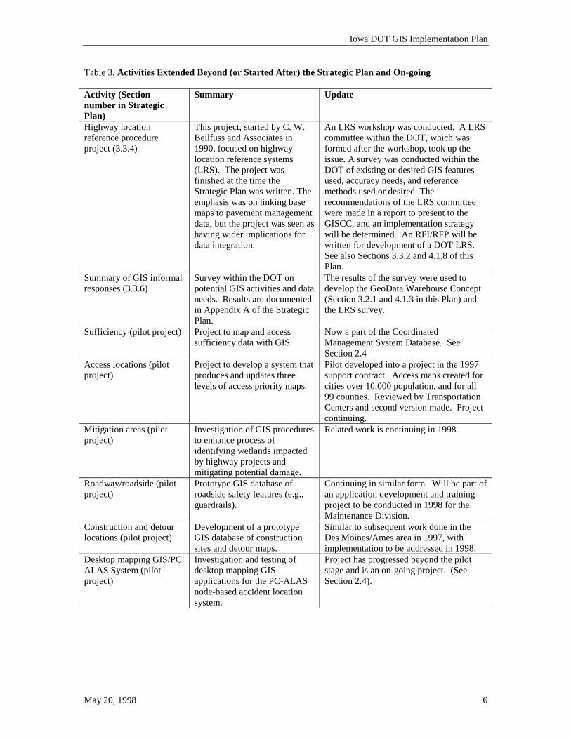
Table 3. Activities Extended Beyond (or Started After) the Strategic Plan and On-going Activity (Section number in Strategic Plan)
Summary Update
Highway location reference procedure project (3.3.4)
This project, started by C. W. Beilfuss and Associates in 1990, focused on highway location reference systems (LRS). The project was finished at the time the Strategic Plan was written. The emphasis was on linking base maps to pavement management data, but the project was seen as having wider implications for data integration.
An LRS workshop was conducted. A LRS committee within the DOT, which was formed after the workshop, took up the issue. A survey was conducted within the DOT of existing or desired GIS features used, accuracy needs, and reference methods used or desired. The recommendations of the LRS committee were made in a report to present to the GISCC, and an implementation strategy will be determined. An RFI/RFP will be written for development of a DOT LRS. See also Sections 3.3.2 and 4.1.8 of this Plan.
Summary of GIS informal responses (3.3.6)
Survey within the DOT on potential GIS activities and data needs. Results are documented in Appendix A of the Strategic Plan.
The results of the survey were used to develop the GeoData Warehouse Concept (Section 3.2.1 and 4.1.3 in this Plan) and the LRS survey.
Sufficiency (pilot project)
Project to map and access sufficiency data with GIS.
Now a part of the Coordinated Management System Database. See Section 2.4
Access locations (pilot project)
Project to develop a system that produces and updates three levels of access priority maps.
Pilot developed into a project in the 1997 support contract. Access maps created for cities over 10,000 population, and for all 99 counties. Reviewed by Transportation Centers and second version made. Project continuing.
Mitigation areas (pilot project)
Investigation of GIS procedures to enhance process of identifying wetlands impacted by highway projects and mitigating potential damage.
Related work is continuing in 1998.
Roadway/roadside (pilot project)
Prototype GIS database of roadside safety features (e.g., guardrails).
Continuing in similar form. Will be part of an application development and training project to be conducted in 1998 for the Maintenance Division.
Construction and detour locations (pilot project)
Development of a prototype GIS database of construction sites and detour maps.
Similar to subsequent work done in the Des Moines/Ames area in 1997, with implementation to be addressed in 1998.
Desktop mapping GIS/PC ALAS System (pilot project)
Investigation and testing of desktop mapping GIS applications for the PC-ALAS node-based accident location system.
Project has progressed beyond the pilot stage and is an on-going project. (See Section 2.4).
Iowa DOT GIS Implementation Plan
May 20, 1998 7
2.2 Progress on Recommendations from the Strategic Plan The Strategic Plan listed a set of 23 recommended activities to be conducted by various entities within the DOT. A few of these are one-time activities that have already been addressed and completed (e.g., select GIS coordinator). Many other activities have been considered on a continuing basis (e.g., provide GIS training, communicate with decision-makers); several of these issues (e.g., evaluate software, identify database issues, and choose applications) have been more thoroughly addressed and documented through the preparation of this plan. 2.3 Existing resources 2.3.1 Organizational Policies/Procedures The GIS Coordinator is the focal point for the development of GIS within the DOT. The Coordinator, however, is guided by the GIS Coordinating Committee (GISCC). The GISCC is made up of representatives from several of the divisions within the DOT. The GIS Coordinator position is currently positioned under the Director of Planning and Programming. The GIS Technical Specialist has also been identified and has taken on the GIS relational database administration tasks. Since the GIS database is a department-wide database, the Technical Specialist is housed in Office of Data Services, Application Technology and serves the entire DOT. GIS development is centralized from a statewide perspective, with most activities being carried out in Ames. Within Ames, however, a decentralized structure is used, with GIS responsibilities largely distributed across several entities. The Office of Transportation Data serves the department-wide needs related to map updates and attribution responsibilities, but with other entities the GIS project work is focused around an individual office’s needs. 2.3.2 Current General GIS Processes Many GIS efforts are underway at the Iowa DOT. These efforts will be addressed in the appropriate sections in this document. It is important, however, to get a thorough understanding of the needed efforts for a successful GIS implementation. These efforts include the general data maintenance processes, and workflow from the creation of data to the delivery of the data to the end user. Currently, the data flow from data creation to the end users is as follows. Data comes into the Office of Transportation Data from yearly field surveys done by internal staff and from inventory information received from counties and cities. New data may also come into the mapping environment from other sources, but the key base record information is collected from the surveys and inventories. These data are then added to the base record database, updated in the maps, and manipulated using DOT developed programs. A small group of personnel is then able to query and create maps, from the manipulated data, for the end users that request the information. Very few end users are able to create the maps on their own.
Iowa DOT GIS Implementation Plan
May 20, 1998 8
GIS ALAS
HighwayAccess
Mapping
CoordinatedManagement
System
DOT Data Users
“One Time”Conversion
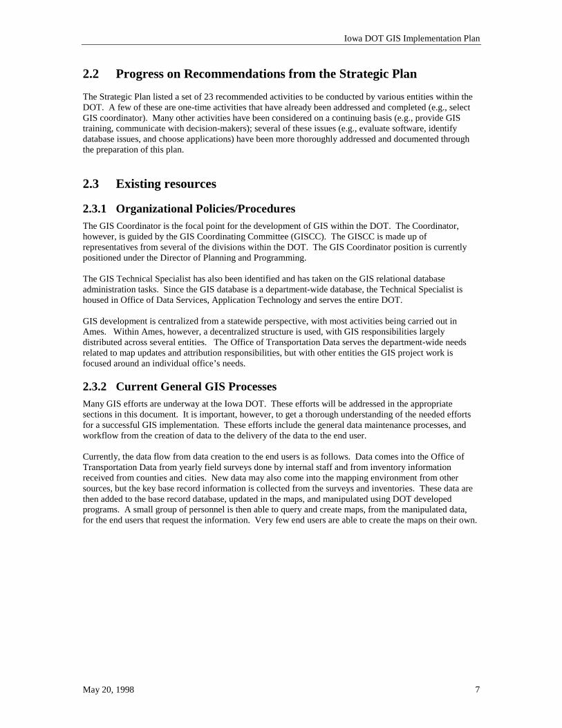
Base Record / Maps(IDMS & CAD)
Map / Base RecordMaintenance
Map / Base RecordQuery
Iowa DOT DataCollectionProcesses
GIS Applications
Other Map Data Sources
Additionally, CTRE has requested map data from the DOT and has translated them into the GIS products used in the projects currently underway at CTRE. While this translation provides the needed data for the project, the translation must be done at some cycle for each of the projects that may be implemented. The exact personnel and process for the update of these data has not been addressed. This current workflow, while workable, is not the most efficient process for getting data to the end user. It also does not provide a true “analysis” environment for an end user, since the user has to request the finished product and has no analytic tools, or is limited to the data that are provided in a project developed by CTRE. The significant GIS efforts undertaken by the Iowa DOT have been started by the GISCC participants and, in most cases, CTRE was asked to help research or implement a portion of the DOT’s GIS under a specific contract or through the GISCC Support Contract. These projects have not taken on the robust scope of work to fully consider the institutionalization of the GIS or the long-term data maintenance issues. These issues are complex and require a concerted planning effort among many groups within the DOT. The GIS Coordinator must continue to address these issues and make them a focus for all internal and external projects completed at the DOT. 2.3.3 Personnel
2.3.3.1 Iowa DOT Personnel The DOT currently has limited personnel devoted strictly to the development and propagation of GIS within the department. Bill Schuman (GIS Coordinator) and Steve Vannoy (GIS Technical Specialist) are the only two personnel devoted to GIS development. Several groups have played and are currently playing key roles in the DOT’s GIS progress; including the GISCC, which has played an important role in policy and procedure development for GIS at the DOT, the GIS Technical Users Group, which guides the software, hardware and data creation efforts, and the Support Teams for each of the Divisions, which provide data maintenance and retrieval tools in the legacy systems.
Iowa DOT GIS Implementation Plan
May 20, 1998 9
2.3.3.2 CTRE Personnel The Transportation Planning and Information Systems Division of CTRE conduct several projects in GIS for the DOT. Key individuals in this area include Reg Souleyrette (Associate Director), Zach Hans (GIS Specialist), Tim Strauss (Research Associate), and David Plazak (Policy Analyst). In addition, several undergraduate and graduate students work on projects related to GIS. 2.3.4 GIS Hardware
2.3.4.1 Iowa DOT Hardware Iowa DOT has purchased very little hardware that is devoted strictly to the development of GIS. A database server was purchased to house the Oracle database for GIS. The server specification is given below. • Dual-Pentium 200Mhz • 20Gig Available Hard Disk (Six – 4GigDrives – RAID configuration uses one) • 256MG RAM (Plans to increase to 1Gig) • CD/ROM • Redundant Array of Interchangeable Disks (RAID) Configured • Windows NT Server Ver 4.0 Additionally, four Pentium-based Intel workstations were purchased for the two GIS staff and as two floating loaner workstation. Two of these workstations are currently in use by the GIS Coordinator and the GIS Technical Specialist. The other two workstations move between different offices to give the users a chance to experience the GIS software and to utilize the GIS pilot applications. The DOT has many other mapping workstations, servers and plotting devices to support the production mapping that has been in place for over ten years. While some of these devices will be used for GIS purposes, they are not included in this inventory. Some Offices within the DOT have started using GIS with the pilot projects and have workstations identified for GIS use.
2.3.4.2 CTRE Hardware In its GIS lab, CTRE has an Intergraph TD-40 Workstation, an Intergraph Interpro Workstation, several Pentium PCs, a CD Writer, Hewlett Packard DesignJet 650C and PaintJet XL300 Plotters, a 60" Summagraphics Digitizing Table, and LAN with large media storage on line. It operates largely in the Windows 95/NT environment. 2.3.5 GIS Software
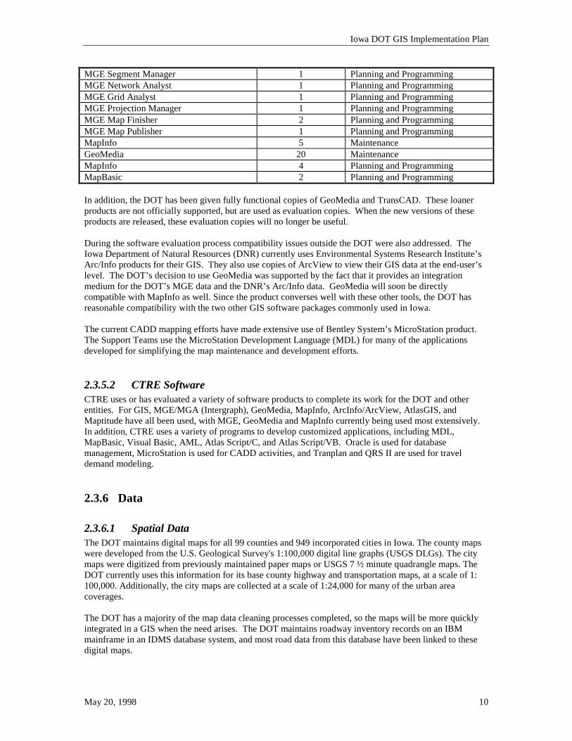
2.3.5.1 Iowa DOT Software Iowa DOT has GIS software that has been purchased for previous GIS pilot projects. The table below is an inventory of the current GIS specific software available at the DOT. Software Name Number of Copies Divisional Owner Oracle 8 Full, 11 Runtime Planning and Programming MGE Nucleus 10 Planning and Programming MGE Mapper 10 Planning and Programming MGE Administrator 10 Planning and Programming MGE Analyst 5 Planning and Programming
Iowa DOT GIS Implementation Plan
May 20, 1998 10
MGE Segment Manager 1 Planning and Programming MGE Network Analyst 1 Planning and Programming MGE Grid Analyst 1 Planning and Programming MGE Projection Manager 1 Planning and Programming MGE Map Finisher 2 Planning and Programming MGE Map Publisher 1 Planning and Programming MapInfo 5 Maintenance GeoMedia 20 Maintenance MapInfo 4 Planning and Programming MapBasic 2 Planning and Programming In addition, the DOT has been given fully functional copies of GeoMedia and TransCAD. These loaner products are not officially supported, but are used as evaluation copies. When the new versions of these products are released, these evaluation copies will no longer be useful. During the software evaluation process compatibility issues outside the DOT were also addressed. The Iowa Department of Natural Resources (DNR) currently uses Environmental Systems Research Institute’s Arc/Info products for their GIS. They also use copies of ArcView to view their GIS data at the end-user’s level. The DOT’s decision to use GeoMedia was supported by the fact that it provides an integration medium for the DOT’s MGE data and the DNR’s Arc/Info data. GeoMedia will soon be directly compatible with MapInfo as well. Since the product converses well with these other tools, the DOT has reasonable compatibility with the two other GIS software packages commonly used in Iowa. The current CADD mapping efforts have made extensive use of Bentley System’s MicroStation product. The Support Teams use the MicroStation Development Language (MDL) for many of the applications developed for simplifying the map maintenance and development efforts.
2.3.5.2 CTRE Software CTRE uses or has evaluated a variety of software products to complete its work for the DOT and other entities. For GIS, MGE/MGA (Intergraph), GeoMedia, MapInfo, ArcInfo/ArcView, AtlasGIS, and Maptitude have all been used, with MGE, GeoMedia and MapInfo currently being used most extensively. In addition, CTRE uses a variety of programs to develop customized applications, including MDL, MapBasic, Visual Basic, AML, Atlas Script/C, and Atlas Script/VB. Oracle is used for database management, MicroStation is used for CADD activities, and Tranplan and QRS II are used for travel demand modeling. 2.3.6 Data
2.3.6.1 Spatial Data The DOT maintains digital maps for all 99 counties and 949 incorporated cities in Iowa. The county maps were developed from the U.S. Geological Survey's 1:100,000 digital line graphs (USGS DLGs). The city maps were digitized from previously maintained paper maps or USGS 7 ½ minute quadrangle maps. The DOT currently uses this information for its base county highway and transportation maps, at a scale of 1: 100,000. Additionally, the city maps are collected at a scale of 1:24,000 for many of the urban area coverages. The DOT has a majority of the map data cleaning processes completed, so the maps will be more quickly integrated in a GIS when the need arises. The DOT maintains roadway inventory records on an IBM mainframe in an IDMS database system, and most road data from this database have been linked to these digital maps.
Iowa DOT GIS Implementation Plan
May 20, 1998 11
2.3.6.2 Attribute Data Attribute data are the values that are stored in the database about a particular map feature. The principal attribute data that are used by the DOT are the data connected to the road linework. These data, often called the “Base Record” data, are a collection of attributes from throughout the DOT. The Base Record data include pavement conditions, roadway characteristics, traffic volumes, crash locations, and many other types of information pertinent to the highway. A complete schematic of the data maintained at the DOT and how the data are all related was developed as part of the Coordinated Management System Database project. See section 2.4. 2.3.7 Related GIS Technologies In addition to the GIS specific applications, several technologies exist within the DOT that utilize maps or enhance the map creation and maintenance. These technologies include video logging, photogrammetry, remote sensing, and global positioning systems.
2.4 Current Activities The Center for Transportation Research and Education conducts several GIS research and development activities at the DOT. Some of this activity has been undertaken through GIS support contracts between the DOT and CTRE, and through specific research projects. Work done by CTRE for the DOT under support contracts covers a wide variety of activities, such as preparing minutes for meetings of the GIS Coordinating Committee, evaluating software packages, providing training, developing pilot projects, evaluating and providing data, and helping to develop this Implementation Plan. Research projects conducted by CTRE on GIS and transportation cover a wide range of topics. Currently, major projects include the Coordinated Management Systems Database, the GIS-based Accident Location and Analysis System, the Iowa Pavement Management Program, and the GIS Traffic Planning Tools (GIS-TPT) project. These are described briefly below. The Coordinated Management Systems Database project is an effort to integrate several databases relevant to the ISTEA management systems in a common GIS environment with a user-friendly interface. The effort is intended to reduce duplication of effort related to data collection, management, and access. A pilot project was begun in mid 1996 and consisted of a series of surveys within the DOT and the construction of a pilot database for two RPAs. The pilot phase was completed in mid 1997, and the current phase, statewide implementation, is scheduled for completion in mid 1998. Because of its central role in GIS implementation, efforts on this project are being closely coordinated with the other activities outlined in this Plan, especially the development of the GeoData Warehouse The GIS-based Accident and Analysis System, originally a pilot project, is being undertaken to extend the capabilities of PC-ALAS into the GIS environment. The first phase of the project has been completed. Over 700,000 crashes (about 70,000 per year over ten years) have been located in GIS, and functionality has been developed to enable users to conduct queries. The product has been useful for developing maps of accidents by time-of-day, surface conditions, and other fields in the ALAS database. In addition, the data are being distributed via CD-ROM along with a simple, free GIS data viewer. The project is currently in Phase 2, in which the product will be enhanced in response to user comments and analytical capabilities will be developed. The GIS-ALAS project is being done in coordination with several related efforts (e.g., collision diagram software, Officer Information Manager, Coordinated Management Systems) and CTRE will continue to work on the integration issues related to these projects and the department-wide GIS efforts. The Iowa Pavement Management Program (IPMP) is an effort to develop a statewide pavement management system for all of the non-NHS highways in the state. The objective of the IPMP is to facilitate
Iowa DOT GIS Implementation Plan
May 20, 1998 12
the decision making process regarding pavement maintenance, rehabilitation, and reconstruction at both the project and network levels. This will be achieved by providing the Iowa DOT and local governmental agencies (cities and counties) with pavement management data, tools, and training. To handle the different data sources and different jurisdictions involved in the project, a GIS database with dynamic segmentation has been developed. The GIS database handles data coming from different sources (Iowa DOT base records, history information, and pavement condition information) in different referencing methods (Km points, literal description, GPS coordinates, etc.). The project started in 1994 and now is in the implementation phase (Phase IV). It is scheduled for completion before the end of 1998. The GIS Traffic Planning Tools (GIS-TPT) project is being conducted to develop tools in three areas. The interchange justification portion of the GIS-TPT project examines the requirements for making changes to the access of the Interstate Highway System. The bypass analysis portion of the project is concerned with developing methods for Iowa DOT personnel to develop and use a model to evaluate a potential bypass project. A third portion of the project is directed toward developing site impact analysis capabilities using existing traffic engineering software packages (Trip Generation, Highway Capacity Software) with a GIS component to manipulate and store relevant data (location, site characteristics, access points, existing traffic volumes, forecasted volumes). The Office of Data Services and the Office of Transportation Data have spent significant time supporting these projects and providing data to these efforts to aid in their success. In addition, several activities conducted by and for the DOT make extensive use of GIS. These include the construction of a statewide freight model (which is using the Tranplan/MapInfo interface developed at CTRE), the Iowa Access Management Awareness Project (which will use GIS-ALAS), and the Improved Employment Data for Transportation Planning project (which uses employment files and GIS address-matching procedures).
Iowa DOT GIS Implementation Plan
May 20, 1998 13
3. Desired Future of GIS at the Iowa DOT 3.1 Goals for GIS at Iowa DOT It is important to have a focused direction and set of goals when starting the implementation of any large project. The Strategic Plan and the GISCC have addressed the vision for GIS, but it is important that the goals for the GIS implementation be implicitly stated as part of the implementation plan to provide a measure of success and direction. The goals for the Iowa DOT’s GIS are stated as follows: • The system should aid the users in their daily job by giving them more information, through easier
processes, to make better decisions. • The GIS data provided in the system should be updated in a timely manner and should have adequate
metadata to allow the user to make good decisions related to accuracy and temporal considerations. • When transportation related GIS data are needed by any entity, the DOT should be the agency of
choice for providing those data. This implies that the DOT has a commitment to provide data for GIS users that are accurate, easily accessible, well documented, and up-to-date.
• All information gathering and technology system efforts should be coordinated so that any data generated can be effectively integrated into the department’s GIS environment.
• The end users should be able to do analysis on their desks rather than requesting the analysis results from another person or division.
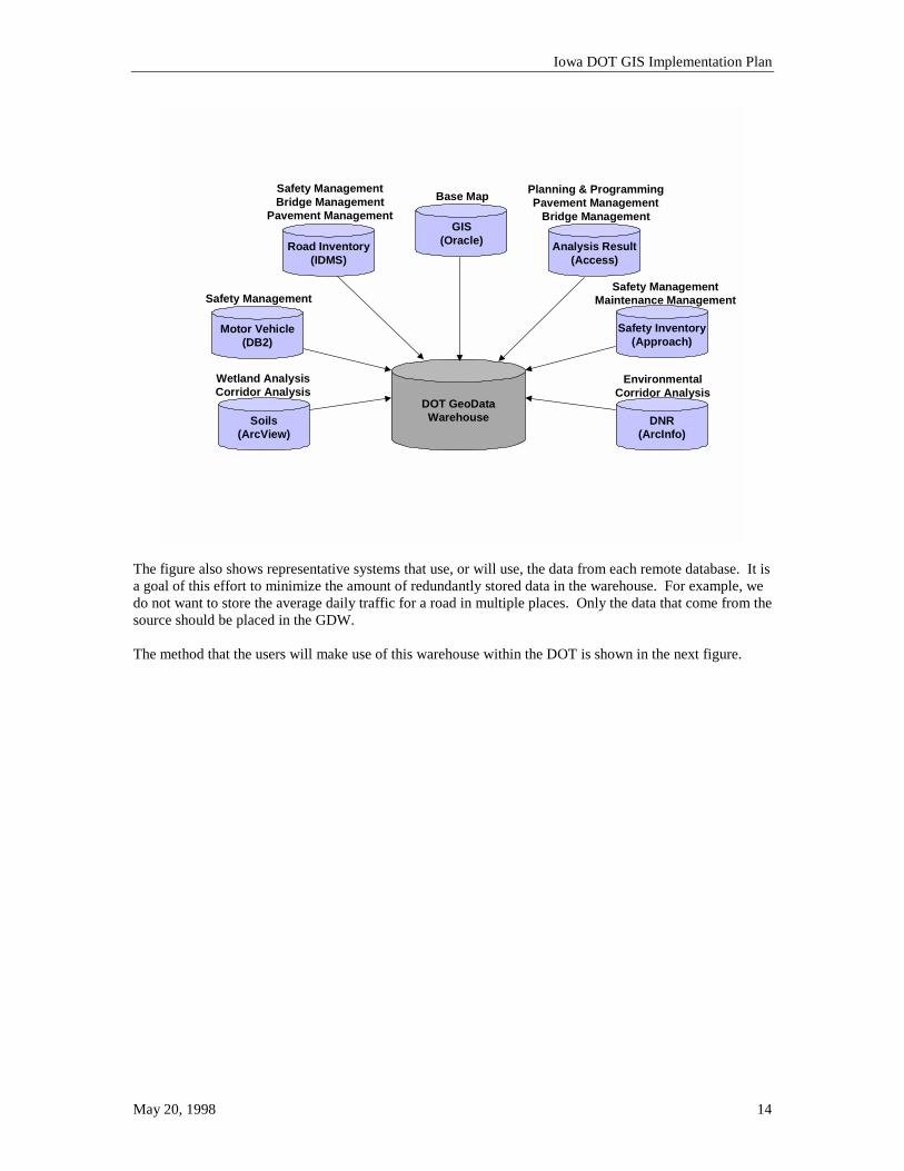
While these goals are not specific, they allow for five units of measure to see if the tasks in the implementation plan are completed with at least one of these goals in mind. If a task does not directly or indirectly help achieve one of the five goals, then the usefulness of that task should be carefully evaluated. 3.2 Short-term Plans for Iowa DOT’s GIS A GIS can become a very complex and interrelated group of datasets. It is important to put a strong foundation in place to support any applications that are developed and to maintain the data. This section describes the architecture of the desired system and the milestones the DOT will aim for over the next eighteen months. The short-term plan must also produce a product that is useful to the end users. While the integration and development of the GIS data will be a benefit, the data must be distributed to the users and be made useful. Several of the GIS projects that have already been started need to provide more timely data and have the data more accessible. This short-term plan addresses these issues and describes the anticipated outcomes for the short-term. 3.2.1 Development of GIS Technical and Institutional Architecture The coordination of GIS efforts and effective use of data within an organization requires the definition of a technical architecture for the effective implementation of the system. While the exact architecture may change over time due to new automation technologies, its general layout will exist for the life of the system. Through an analysis of the requirements for data sharing, it has been determined that the DOT should implement a structure with the key component being a “GeoData Warehouse” (GDW). The following figure show an example of the data that will be combined to create the GDW. This is not a complete representation of all the data to be included, but represents the breadth of the data sources.
Iowa DOT GIS Implementation Plan
May 20, 1998 14
DOT GeoDataWarehouse
Safety Inventory(Approach)
Analysis Result(Access)
GIS(Oracle)Road Inventory
(IDMS)
Motor Vehicle(DB2)
DNR(ArcInfo)
Soils(ArcView)
Safety Management
Safety ManagementBridge Management
Pavement ManagementBase Map Planning & Programming
Pavement ManagementBridge Management
EnvironmentalCorridor Analysis
Wetland AnalysisCorridor Analysis
Safety ManagementMaintenance Management
The figure also shows representative systems that use, or will use, the data from each remote database. It is a goal of this effort to minimize the amount of redundantly stored data in the warehouse. For example, we do not want to store the average daily traffic for a road in multiple places. Only the data that come from the source should be placed in the GDW. The method that the users will make use of this warehouse within the DOT is shown in the next figure.
Iowa DOT GIS Implementation Plan
May 20, 1998 15
DOT GeoDataWarehouse
(GDW)
GIS ALASHighwayAccess
Mapping
PavementManagement Others
GIS Analysts
General GIS Users
GIS MaintenanceStaff
GIS(Oracle)
The GDW is the hub of the GIS wheel at the DOT. All data are stored, either directly or indirectly, in the warehouse, although all data, depending on data privacy issues, may not be exposed to all users. The format in which the data are stored in the GDW will depend on its native format. If the data are sent to the DOT, or are maintained in the DOT, in a format readily usable by the GIS software, then a translation into Oracle is not necessary. For instance, the Department of Natural Resources’ data are maintained in Arc/Info, so the DOT will simply bring those data over to a server in the DOT and store them in their native format. Similarly, the Department of Motor Vehicles’ data may not need to be translated to Oracle to be used in the GIS if a gateway is provided to the DB2 database that is utilized by that division. For the data that are maintained by the DOT, it is likely that two environments will be established for the maintenance and delivery. One environment will be for the GIS Maintenance Users and will be the area where all the changes to the maps occur and where the attribute linkages to the map are edited. The second environment will be the production environment that is provided to the end users and will be a snapshot of the first environment that is extracted on some cycle. The map data will be verified to ensure their accuracy before being moved into production and will buffer the end users from the day-to-day map edits. This is necessary, since the changes to the map must be cleaned and verified to ensure their integrity for use in the Desktop GIS applications.
3.2.1.1. GIS Analysis Users The Iowa DOT GIS Analysis Users are connected to the GDW through the LAN and have two-way data access to the GeoData Warehouse. These users will be utilizing the data on the GDW in a read-only mode, but will potentially create new data, through GIS analysis, for the rest of the DOT to utilize. Any useful data from the analysis done on these seats will be put in a public area for all DOT users to share. These users do not update the base data, but they do have the ability to post new data to the GDW.
Iowa DOT GIS Implementation Plan
May 20, 1998 16
3.2.1.2. GIS Maintenance Users The GIS Maintenance Users, also connected via the LAN, have read access to the DOT maintained GDW data and write access to the GIS Database. The write access may be in a development environment, rather than directly to the production warehouse data, but the production data will be updated on a cycle determined by the users and management. These users will update the map features, the feature attributes, and any needed GIS analysis files. Section 5.3 of the GIS Strategic Plan identifies three levels of personnel involved in the support of a GIS: core, master, and other users, as defined by NCHRP 359. The Strategic Plan suggests the renaming of these levels as “GIS Support Staff”, “GIS Application Developers”, and “GIS Users”. This definition of the personnel does not address the personnel needed for maintenance of the GIS map and attribute data, but only the GIS and application design staff, application development staff, and end users. As a result, a fourth level of user is defined for the implementation of GIS at the Iowa DOT: the GIS Data Maintenance Staff.
3.2.1.3. General GIS Users The last set of spokes of the hub will be the GIS Users. This group will far outnumber any of the other groups and will most often use the data through a custom application over the LAN. These users will have read-only access to all the data. The application will allow for the users to store information to their personal systems, but will not allow them to update any data on the GDW. This will allow the users to pull small portions of the data to their personal systems to conduct studies in static time without the worry of the data being updated on the GDW.
3.2.1.4. Other GIS Data Sources In addition to the data maintained by the DOT, other data will be made available on the GDW. This may be GIS data from counties, cities, or other state agencies. These data will be translated (if necessary), stored on the GDW, and updated on some cycle depending on the dynamic nature of the data in question. A systematic process will be developed for the storage and easy retrieval of the metadata related to this and all data stored in the GDW. For example, data from the National Wetlands Inventory and US Census may be integrated into the GIS system to further enhance the information provided to the end user. Data from the Department of Natural Resources (DNR) will also be integrated into the Iowa DOT GIS. 3.2.2 Metadata Definition The measure of truly useful data is not how effectively a single person can use the data, but how effectively a large organization or even an outside organization can use the data. It is obvious from the industry’s years of information system experience that if data are not well documented, they will be useful to only a very small group of people. Thus, the term metadata (data about data) was developed. Information system personnel have come to expect metadata on all the information they receive, and in turn, have developed metadata for many of their systems. The proliferation of the Internet as a data distribution method has proved that digital metadata is needed in almost every situation. Due to the DOT’s public service role, and because of our goal to create and provide transportation data, it is necessary to produce metadata for all of our GIS data. CTRE has started a project to inform the DOT of the available metadata processes that have been implemented in the country. In addition, CTRE will facilitate the development of the DOT’s GIS metadata standard. 3.2.3 Improvement of Spatial Data Accuracy The maps developed by the Office of Transportation Data have an accuracy of approximately 1:100,000 or 1:24,000, depending on the data source. While these maps work well for most management system or inventory system applications, they are not as useful in wetland or utility analysis. The maps are also less
Iowa DOT GIS Implementation Plan
May 20, 1998 17
accurate than the current GPS data that are often collected, so an improved base map would be very beneficial when comparing GPS data to the highway centerlines. The exact method for improving the accuracy is not addressed in this document since the best method is yet to be identified, but it is anticipated that GPS and/or orthorectified aerial photography will prove to be the most useful tools for collecting the more accurate data. It is important to point out that GPS can be used to enhance the accuracy of the base map without utilizing centimeter accurate GPS. GPS data can be collected at many different accuracies and depend on the processes used to collect and correct the data as to the exact accuracy that is obtained. It is anticipated that points in the one to five meter accuracy range will be used to enhance the base map. 3.2.4 Location and Linear Referencing System Strategy The Location and Linear Referencing Team has finalized its recommendations in a report. These recommendations will be reviewed and hopefully accepted by the management team. Defining and adopting a linear referencing system (LRS) for use in the GIS, and in the DOT as a whole, is a necessity when integrating data from different sources. Establishing a common LRS will aid the Intelligent Transportation System projects in addition to the GIS integration efforts since GIS will provide much of the base information for the ITS projects. The acceptance of a standard referencing system can not be a division-by-division option. A consensus needs to be built among all divisions and the LRS should be accepted at a departmental level, with all divisions taking advantage of the new standard. This means that the LRS must integrate existing data, it must provide an easy to understand data collection method for the field personnel, and it must be usable in the GIS software and management systems. The DOT will develop a Request for Proposals to develop a practical LRS that is compatible with our GIS applications and field data capture processes. The short-term goals are to develop the RFP, to secure funding for this project and to achieve the LRS pilot in the next eighteen months. 3.2.5 GIS Applications Desktop GIS software has come a long way in the last two years. It is easier to use, more reliable and productive, and less expensive. It is still necessary, however, to customize this software for specific applications to make it more intuitive for the end user. The software that GIS vendors develop must be very “general”, so it satisfies many different customers’ needs. As a result, most GIS software is really only a collection of tools. For that reason, almost every organization that uses a desktop GIS customizes the software to some extent for their specific workflows.
3.2.5.1. Complete Current GIS Application Projects Several efforts are underway at the DOT as described in Chapter 2. The projects described below are anticipated to provide the largest benefits for future development and to provide a useful tool to many users in the state of Iowa. The Statewide Coordinated GIS project was initiated to start the integration of data for transportation management systems. This project has been reviewed with the GIS Coordinator and has been refocused to be sure it is integrated with the larger DOT GIS architecture. When this project is complete, it will allow the end users to have easier access to the GIS data that are added to the GDW. It is anticipated that a limited number of features will be maintained in the DOT’s MGE projects by the time this project is delivered, but a wealth of data will be available in the GDW from other agencies, such as the Department of Natural Resources. It is anticipated that this project will be completed in the summer of 1998 and additional development of the management systems will be considered at that time. The GIS - Accident Location and Analysis System (ALAS) project initially started as a process to migrate PC-ALAS to newer technologies and has grown into a GIS oriented program. GIS-ALAS needs to be fully
Iowa DOT GIS Implementation Plan
May 20, 1998 18
integrated into the base map data maintenance workflows and the new technologies being explored for locating crashes and automating the crash reporting. Current efforts within the DOT and CTRE are addressing these issues. The Iowa Pavement Management Program (IPMP) has developed a dynamic segmentation model for the non-National Highway System pavement data. This system must also be integrated into the GIS maintenance workflows. It is also desired to look at the NHS pavement data to determine the processes that would need to be developed to better integrate the two systems and make a more seamless pavement management interface within the GIS. The Maintenance Division has started an aggressive project to capture and display the locations of its roadside safety features (i.e., guardrails) in the GIS software. This division has also undertaken a highway access project that is GIS enabled. It is anticipated that both of these projects will produce significant benefit to the Maintenance Division.
3.2.5.2. Identification of New Applications The DOT has already started the process of customizing GIS software to produce GIS applications specific to Iowa and Iowa DOT. The Statewide Coordinated GIS and GIS-ALAS projects are both examples of the GIS software being used as a toolbox of functions that are customized around a specific workflow and data structure. Additional applications need to be identified for better integration of data and for better utilization of data that currently exist in the DOT. The ISTEA Management System functional groups (Pavement, Bridge, Safety, Intermodal, Congestion, and Public Transit) have been common areas to identify new applications. The wetland and environmental areas and the Maintenance Division of the DOT are also very good areas to explore for use of GIS. It is very important that the applications identified help solve existing workflow problems in the DOT by providing data to the users that they never had before, or to simplify a cumbersome process that takes place now. These applications are what will “institutionalize” GIS and make it a useful and necessary tool in the day-to-day lives of the DOT personnel.
3.2.5.3. Integration of New or Existing Systems Integration of new or existing systems within the GIS is important in the overall success of the system. The Records Management System, for example, is a powerful tool unto itself, but with the data integration capabilities of GIS, the system could be even more valuable to the DOT. Current efforts are underway to ensure the integration of such projects. The integration of the GIS in the digital video logging system is also a very powerful capability. The current Mandli system at Iowa DOT uses a map, but the data are available only on a few computers in the DOT. The GIS application should be the interface to the digital video log data in the future. This would provide the end user the ability to query for a specific stretch of road, a bridge, a sign, or other road feature, locate the feature on the map, and then access the digital video log for that location on the network. This would simplify the user’s desktop by allowing all this to happen in a single working environment. New Intelligent Transportation System (ITS) projects should also be considered prime candidates for the integration of GIS. While integration of ITS is considered a long-term goal in this plan, integration can be started immediately. See Long-term Plans for Iowa DOT’s GIS, Section 3.3, for more information on ITS integration.
3.2.5.4. Development of GIS Tools for the Public The GIS applications that the DOT develops may not be only internal analysis and business oriented tools, but may include applications used by the general public. Such systems may be Internet-based tools that view a very specific portion of the DOT GIS data to provide information to the public. Examples of this type of system may include the highway condition map for travelers in the winter or construction status maps during the summer construction season.
Iowa DOT GIS Implementation Plan
May 20, 1998 19
3.2.6 GIS Training Training of the Divisional Support Teams, the GIS Maintenance Users and the GIS General Users must be accomplished as a short-term goal to ensure the success of the GIS. It is important to train each group on the specific tools needed to accomplish their specific mission related to GIS. One training class can not accommodate all the different users. The training for the Divisional Support Teams must be organized around the loading, configuration, and maintenance of the underlying system and software. It should also point out system performance hints and how to optimize the GIS software in conjunction with other software at the DOT. The GIS Maintenance Users will be trained primarily in MGE and the custom tools that are developed to facilitate the maintenance of the base map and the related data. This training will focus on the processes need to maintain the map features in a GIS environment and focus less on the use of mapping in a CADD environment. The GIS General Users will train primarily on the use of GeoMedia. These groups will also be trained on the custom applications developed in conjunction with the GIS software (i.e., Transportation Management Systems) and how to best utilize the data that are available in the GDW. Other GIS users will be given special training on an as-needed basis for special projects or on products that only a few DOT personnel are using. 3.2.7 Short-term Goal Summary The short-term goals and tasks are shown below with the anticipated corresponding products that will be provided. Tasks • Define and develop the GIS architecture • Develop the GeoData Warehouse, including the Base Record data that are functionally subdivided • Develop GIS metadata • Evaluate processes to improve the spatial data accuracy • Compete current GIS application projects and define new projects • Develop and fund Linear and Location Reference System RFP • Training Products • Establish the GIS data and resource infrastructure • Statewide Coordinated GIS project with metadata and workflow for updating the data • GIS-ALAS with the ability to update the road network • Maintenance Division GIS roadside safety feature inventory project • Non-NHS pavement management program • Linear and Location Referencing System pilot and implementation strategy • Trained personnel 3.3 Long-term plans for Iowa DOT’s GIS The development of a long-term vision for the GIS is often important to help define the process that may need to be taken in the short-term. A long-term plan is most often where the largest pay-off is found in a GIS, since the start-up costs are often large and the short-term success does not always give a positive benefit/cost. This section will discuss the vision for the GIS at the Iowa DOT.
Iowa DOT GIS Implementation Plan
May 20, 1998 20
3.3.1 Integrated Transportation Management Systems Several states have leveraged their GIS investments to create Transportation Management Systems (TMS). The ISTEA mandates for TMSs started the DOTs down the path of creating these systems, and even though the mandates have been taken away, the DOTs have seen the worth of an effective TMS and continue to develop these systems. The GIS-T/ISTEA Pooled Fund Study also addressed the TMS needs, and provided a high-level business paradigm for development of an effective TMS. Some DOTs, such as the Mississippi DOT, endeavored to build a robust Transportation Management Information System (TMIS). This system includes a pavement, bridge, and safety management module, but also included an interface to the digital video log system, a small document management system, the highway project management data, and an ad hoc query interface. While the Iowa DOT may not choose to endeavor into such a large project in one step, the integration of all those systems needs to be considered as a goal of the Iowa DOT. 3.3.2 Linear Referencing System and Database Implementation The full implementation of the Linear and Location Referencing System will be a long-term goal and will be an integral part of the final dynamic segmentation database model that will be established. The final reconstruction of the Base Record data will occur when the pilot is completed and the LRS is starting the implementation phase. 3.3.3 Overweight/Oversize Truck Routing System The efficiency of the manual processes that currently take place to route an oversized or overweight vehicle through Iowa can be improved dramatically through the use of an automated procedure. GIS could provide the base for a routing system and much of the needed software for routing exists in the desktop GIS packages currently available. The complexities of a routing system, however, are not technical, but logistical. Construction restriction data must arrive in a timely fashion, and must be known not only for the current day, but for the day that the oversized vehicle wants to travel. Bridge clearance information must be accurate in the database, and ramp and alternative route data must be available. 3.3.4 Intelligent Transportation System Support Many intelligent transportation systems (ITS) projects include or require the use of a map. That map most often needs basic attribution and is a good tool for providing base information to the ITS user in addition to the specific ITS data that the system in question provides. Automatic Vehicle Location (AVL) and Commercial Vehicle Operations (CVO) are tools that always needs a map of some type, and are becoming a more commonplace capability in newer vehicles. The consideration of how the GIS will be integrated into a new ITS project must be addressed by all committees that may look at ITS projects. Utilizing GIS as the data integrator for the ITS will provide continuity of the systems for the end users and will provide more complete information to the user. It is important that “islands of information” or remote systems are not created. The process of not integrating the data is what causes duplication of efforts and wastes resources. ITS may also provide data to a GIS analysis or inventory database, so it is important to have the ITS projects linked into the GDW. One system that is currently being considered by the DOT is a highway closure and restriction system. This system would allow the user to enter an incident that occurs on the network and possibly control traffic flow on the system to minimize congestion due to the incident. If, for example, the incident were a flammable chemical spill on a highway, the thing that would be a concern would be the facilities immediately adjacent to the spill. If the GIS were integrated with the incident management system, the

Iowa DOT GIS Implementation Plan
May 20, 1998 21
user could identify the adjacent facilities, such as rail lines, find out who the lines belong to, and contact the appropriate person to warn them of the incident. Another ITS project underway at Iowa DOT is FORETELL. FORETELL is a multi-state initiative bringing Intelligent Transportation Systems (ITS) together with advanced weather systems prediction to create operational highway maintenance management and traveler information systems throughout North America. The FORETELL consortium consists of a group of states (Iowa, Missouri, Wisconsin, Minnesota and Illinois), U.S. and Canadian federal agencies (National Weather Service, NOAA's Forecast Systems Laboratory, Environment Canada, etc.) and private sector companies (Castle Rock Services, Matrix Management Group, American Mobile Satellite, etc.) that are developing a proof of concept test for a regional system. The regional system will be created to provide and operate ITS Service Centers that cover at least five mid-western states and the Canadian province of Ontario. The expected outcome is successful ITS management and information dissemination in support of highway managers and traveling public needs, including pavement condition forecasting. FORETELL's mission is to deliver the benefits of advanced weather systems and ITS to travelers, shippers and transportation system operators across North America within three to five years. It is important that Iowa’s GIS be able to integrate with FORETELL and the other states’ GIS systems to provide reasonably consistent interfaces and data.
Iowa DOT GIS Implementation Plan
May 20, 1998 22
4. Implementation Plan The remainder of this document is devoted to defining the processes necessary to move from the current status of GIS at the Iowa DOT, as defined in Chapter 2, to the desired future state of GIS, as defined in Chapter 3. 4.1 Identification of Necessary Tasks The following steps or tasks must be completed to ensure successful implementation of GIS at the Iowa DOT. A complete list of the tasks is given here, but in the following sections each task is fully explained and, where necessary, subtasks are identified. • Define Desired GIS Applications • Define Necessary GIS Map Features • Define GIS System Architecture • Define GIS Resource and Training Needs • Design GIS Maintenance Processes • Design GIS Database • Define GIS Information and Marketing Strategy • Design and Implementation of a Linear Referencing System • Plan the Integration of GIS Related Applications • Design and Build GIS/ITS Applications It is important to point out that many of these tasks have been started and are in various stages of completion. While these tasks are listed in the approximate order they should be completed, it is important to realize that many of the tasks may be going on in parallel. 4.1.1 Define Desired GIS Applications The definition of a GIS application is, “a custom interface built on the base GIS software to simplify data access and analysis for a specific application”. CTRE has done significant work with the DOT to develop a list of potential GIS applications and the supporting map features that would be required for these applications. As new personnel are hired into the DOT and as GIS becomes more understood by the users, additional projects have been identified. The list of projects will continue to grow and change as projects are completed and new ones are identified. The on-going development of the GeoData Warehouse and the supporting Transportation Management Systems are larger projects that will continue for several years. Smaller projects, specific to an office or division, continue to be identified and addressed as part of the GIS implementation. It is the successful completion of the GeoData Warehouse that will provide easier access to the data, and thus make the smaller GIS projects more successful. 4.1.2 Define Necessary GIS Map Features The Office of Transportation Data currently maintains over one thousand maps of Iowa and the transportation features within Iowa. These map data will provide much of the initial spatial information for the Iowa DOT’s GIS. The users should help define what features are required in the GIS by defining what is necessary to help them complete their daily work or GIS analysis. The applications defined in the previous implementation step will also reveal a significant number of the necessary features. Once the features themselves are identified, the associated attributes that are needed must also be defined. The attributes are the informational items carried on each feature. For instance, on the feature County, several attributes related to the county’s size, population, and identification could be carried in the GIS. The Road feature may have many attributes related to the traffic volume, highway condition, road characteristics, etc.
Iowa DOT GIS Implementation Plan
May 20, 1998 23
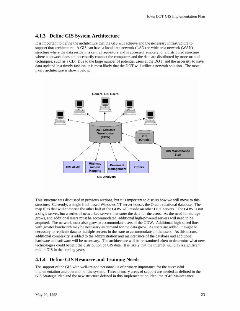
4.1.3 Define GIS System Architecture It is important to define the architecture that the GIS will achieve and the necessary infrastructure to support that architecture. A GIS can have a local area network (LAN) or wide area network (WAN) structure where the data reside in a central repository and is accessed remotely, or a distributed structure where a network does not necessarily connect the computers and the data are distributed by more manual techniques, such as a CD. Due to the large number of potential users at the DOT, and the necessity to have data updated in a timely fashion, it is most likely that the DOT will utilize a network solution. The most likely architecture is shown below:
DOT GeoDataWarehouse
(GDW)
GIS ALASHighwayAccess
Mapping
PavementManagement Others
GIS Analysts
General GIS Users
GIS MaintenanceStaff
GIS(Oracle)
This structure was discussed in previous sections, but it is important to discuss how we will move to this structure. Currently, a single Intel-based Windows NT server houses the Oracle relational database. The map files that will comprise the other half of the GDW will reside on other DOT servers. The GDW is not a single server, but a series of networked servers that store the data for the users. As the need for storage grows, and additional users must be accommodated, additional high-powered servers will need to be acquired. The network must also grow to accommodate users of the GDW. Additional high-speed lines with greater bandwidth may be necessary as demand for the data grow. As users are added, it might be necessary to replicate data to multiple servers in the state to accommodate all the users. As this occurs, additional complexity is added to the administration and maintenance of the database and additional hardware and software will be necessary. The architecture will be reexamined often to determine what new technologies could benefit the distribution of GIS data. It is likely that the Internet will play a significant role in GIS in the coming years. 4.1.4 Define GIS Resource and Training Needs The support of the GIS with well-trained personnel is of primary importance for the successful implementation and operation of the system. Three primary areas of support are needed as defined in the GIS Strategic Plan and the new structure defined in this Implementation Plan: the “GIS Maintenance
Iowa DOT GIS Implementation Plan
May 20, 1998 24
Staff”, “GIS Support Staff” and “GIS Application Developers”. The following sections will give a general structure of a training plan and will provide an overview of support and training considerations for GIS.
4.1.4.1 GIS Maintenance Staff The GIS Maintenance staff will be the personnel that maintain the map and attribute information as a primary part of their job. Currently, these tasks are being performed in the CADD and mainframe environment by the Transportation Data staff. This staff is well trained in the use of MicroStation and the interfaces to the IDMS database on the IBM mainframe, but will need to be retrained to understand the data structure and workflows required to maintain GIS map data. Within the GIS Maintenance Staff two groups of personnel can be identified: the GIS Development Specialists and the GIS Data Maintenance Specialists. The GIS Development Specialists are experts in the use of the GIS maintenance software (MGE). This group will be responsible for defining necessary workflows, GIS network construction, GIS data distribution, and supporting the GIS Data Maintenance Specialists in their work. The focus of this group will be to move the data into a structure that is useful not only by themselves and the maintenance organization, but also the general GIS users in the DOT and perhaps the general public. This group will also be responsible for ensuring the GIS Metadata is maintained and accurate. The GIS Data Maintenance Specialists receive information about how the maps need to be updated and utilize the maintenance software to change the map and any related attribution. This group is responsible for applying appropriate CADD and mapping techniques to maintain the GIS data and to keep the map accurate.
4.1.4.2 GIS Support Staff The GIS Support Staff will need to understand the complete GIS architecture and all the software that will be utilized by the DOT users. This could be a significant amount of software, and it is a question as to whether the existing structure of the support staff within each division is the best structure for the GIS support. The concern is that each division’s support personnel might have to learn three or more software packages, depending on the division. This is in addition to the software they would already support. A GIS support team that spans multiple divisions should be considered, especially in the short-term, to minimize the amount of software any one person may need to know. For this reason, a position called Desktop GIS Support (Business Workflows) must be established that crosses the Divisional structure for supporting the General GIS Users. A strategy needs to be developed for training the support personnel on the new software. Transportation Data will have the largest initial training curve, since they will be using the more complex data maintenance software. Transportation Data will also need to start developing the maps and associated data early in the process, so it is imperative that their training be considered first. This includes not only the Planning Support Staff that would support the software, but also the GIS Data Maintenance Specialists that use the software on a daily basis. The GIS Support Staff also includes the Oracle Database Administrator. The Administrator will require extensive training to manage the new database system in a productive and efficient manner. The Administrator will be responsible for all security, backup procedures, optimization, architecture review, and database design.
4.1.4.3 GIS Application Developers The GIS Application Developers will work closely with the GIS Support Staff, and in fact, may be the same personnel in some instances. This group’s responsibility will be to design and develop new GIS applications as identified by the end users. This group will also need to be tightly integrated into the efforts of the consultants that might be involved in the GIS application development. The involvement of the GIS Application Developers in consultant efforts will allow the DOT to more easily take over and manage applications that may be developed outside our staff.
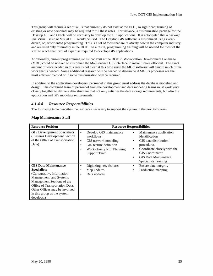
Iowa DOT GIS Implementation Plan
May 20, 1998 25
This group will require a set of skills that currently do not exist at the DOT, so significant training of existing or new personnel may be required to fill these roles. For instance, a customization package for the Desktop GIS and Oracle will be necessary to develop the GIS applications. It is anticipated that a package like Visual Basic or Visual C++ would be used. The Desktop GIS software is customized using event-driven, object-oriented programming. This is a set of tools that are relatively new in the computer industry, and are used only minimally in the DOT. As a result, programming training will be needed for most of the staff to reach that level of expertise required to develop GIS applications. Additionally, current programming skills that exist at the DOT in MicroStation Development Language (MDL) could be utilized to customize the Maintenance GIS interface to make it more efficient. The exact amount of work needed in this area is not clear at this time since the MGE software will handle much of the work that is needed. Some additional research will be needed to determine if MGE’s processes are the most efficient method or if some customization will be required. In addition to the application developers, personnel in this group must address the database modeling and design. The combined team of personnel from the development and data modeling teams must work very closely together to define a data structure that not only satisfies the data storage requirements, but also the application and GIS modeling requirements.
4.1.4.4 Resource Responsibilities The following table describes the resources necessary to support the system in the next two years. Map Maintenance Staff Resource Position Resource Responsibilities GIS Development Specialists (Systems Development Section of the Office of Transportation Data)
• Develop GIS maintenance workflows
• GIS network modeling • GIS feature definition • Work closely with Planning
Support Team
• Maintenance application identification
• GIS data distribution procedures
• Coordinate closely with the GIS Coordinator
• GIS Data Maintenance Specialists Training
GIS Data Maintenance Specialists (Cartography, Information Management, and Systems Management Sections of the Office of Transportation Data. Other Offices may be involved in this group as the system develops.)
• Digitizing new features • Map updates • Data updates
• Ensure data integrity • Production mapping
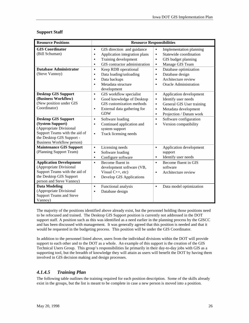
Iowa DOT GIS Implementation Plan
May 20, 1998 26
Support Staff Resource Positions Resource Responsibilities GIS Coordinator (Bill Schuman)
• GIS direction and guidance • Application integration plans • Training development • GIS contractor administration
• Implementation planning • Statewide coordination • GIS budget planning • Manage GIS Team
Database Administrator (Steve Vannoy)
• Keep RDB operational • Data loading/unloading • Data backups • Metadata structure
development
• Database optimization • Database design • Architecture review • Oracle Administration
Desktop GIS Support (Business Workflow) (New position under GIS Coordinator)
• GIS workflow specialist • Good knowledge of Desktop
GIS customization methods • External data gathering for
GDW
• Application development • Identify user needs • General GIS User training • Metadata development • Projection / Datum work
Desktop GIS Support (System Support) (Appropriate Divisional Support Teams with the aid of the Desktop GIS Support - Business Workflow person)
• Software loading • Continued application and
system support • Track licensing needs
• Software configuration • Version compatibility
Maintenance GIS Support (Planning Support Team)
• Licensing needs • Software loading • Configure software
• Application development support
• Identify user needs Application Development (Appropriate Divisional Support Teams with the aid of the Desktop GIS Support person and Steve Vannoy)
• Become fluent in development software (VB, Visual C++, etc)
• Develop GIS Applications
• Become fluent in GIS software
• Architecture review
Data Modeling (Appropriate Divisional Support Teams and Steve Vannoy)
• Functional analysis • Database design
• Data model optimization
The majority of the positions identified above already exist, but the personnel holding those positions need to be refocused and trained. The Desktop GIS Support position is currently not addressed in the DOT support staff. A position such as this was identified as a need earlier in the planning process by the GISCC and has been discussed with management. It was generally agreed that this position is needed and that it would be requested in the budgeting process. This position will be under the GIS Coordinator. In addition to the personnel listed above, users from the individual divisions within the DOT will provide support to each other and to the DOT as a whole. An example of this support is the creation of the GIS Technical Users Group. This group’s responsibilities lie primarily in their day-to-day jobs with GIS as a supporting tool, but the breadth of knowledge they will attain as users will benefit the DOT by having them involved in GIS decision making and design processes.
4.1.4.5 Training Plan The following table outlines the training required for each position description. Some of the skills already exist in the groups, but the list is meant to be complete in case a new person is moved into a position.
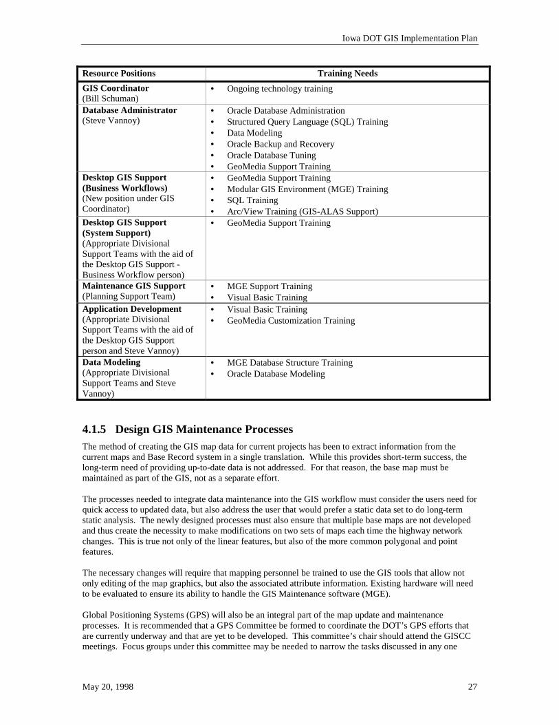
Iowa DOT GIS Implementation Plan
May 20, 1998 27
Resource Positions Training Needs GIS Coordinator (Bill Schuman)
• Ongoing technology training
Database Administrator (Steve Vannoy)
• Oracle Database Administration • Structured Query Language (SQL) Training • Data Modeling • Oracle Backup and Recovery • Oracle Database Tuning • GeoMedia Support Training
Desktop GIS Support (Business Workflows) (New position under GIS Coordinator)
• GeoMedia Support Training • Modular GIS Environment (MGE) Training • SQL Training • Arc/View Training (GIS-ALAS Support)
Desktop GIS Support (System Support) (Appropriate Divisional Support Teams with the aid of the Desktop GIS Support - Business Workflow person)
• GeoMedia Support Training
Maintenance GIS Support (Planning Support Team)
• MGE Support Training • Visual Basic Training
Application Development (Appropriate Divisional Support Teams with the aid of the Desktop GIS Support person and Steve Vannoy)
• Visual Basic Training • GeoMedia Customization Training
Data Modeling (Appropriate Divisional Support Teams and Steve Vannoy)
• MGE Database Structure Training • Oracle Database Modeling
4.1.5 Design GIS Maintenance Processes The method of creating the GIS map data for current projects has been to extract information from the current maps and Base Record system in a single translation. While this provides short-term success, the long-term need of providing up-to-date data is not addressed. For that reason, the base map must be maintained as part of the GIS, not as a separate effort. The processes needed to integrate data maintenance into the GIS workflow must consider the users need for quick access to updated data, but also address the user that would prefer a static data set to do long-term static analysis. The newly designed processes must also ensure that multiple base maps are not developed and thus create the necessity to make modifications on two sets of maps each time the highway network changes. This is true not only of the linear features, but also of the more common polygonal and point features. The necessary changes will require that mapping personnel be trained to use the GIS tools that allow not only editing of the map graphics, but also the associated attribute information. Existing hardware will need to be evaluated to ensure its ability to handle the GIS Maintenance software (MGE). Global Positioning Systems (GPS) will also be an integral part of the map update and maintenance processes. It is recommended that a GPS Committee be formed to coordinate the DOT’s GPS efforts that are currently underway and that are yet to be developed. This committee’s chair should attend the GISCC meetings. Focus groups under this committee may be needed to narrow the tasks discussed in any one

Iowa DOT GIS Implementation Plan
May 20, 1998 28
group. The focus groups may be GPS for surveying (sub-centimeter accuracy), GPS for field feature collection (meter accuracy for new features), and GPS for map maintenance and updates (meter accuracy for map updates and LRS). This committee should address the following topics: • Use of GPS for collecting data in the field (for GIS and surveying) • Accuracy expectations for different data usage • Attribute collection methods for GPS data use in GIS • Hardware and software recommendations • Procedures manuals for GPS usage • Correction products and hardware (base station setup, real-time correction coverage, etc.) 4.1.6 Design Database A GIS database can be a very complex system. It includes many new elements that may not be maintained currently. For example, the DOT has city boundaries in the base map and city information in our databases, but we do not have the two linked, or “geocoded”, in a GIS environment. A good design to accommodate the geocoded data is key to the usefulness of the GIS. While it is important to achieve the optimal relational database design by data modeling and normalization processes, the database must also accommodate the GIS software that utilizes the database structure. Any applications that are developed to enhance the GIS must also be able to use the database when completed; so considerable forethought about the potential use of the GIS database should occur before the design is started. In order to ensure a good data model, a logical data model should be completed, and a physical data model should be developed from the logical model. This model should include not only the currently available data, but also any data that might be considered part of the GIS in the foreseeable future. The short term solution for getting base record information into Oracle will be to continue the maintenance of the data in IDMS, do a simple restructuring of the data, and copy the data into Oracle. This will minimize the impact on current Base Record maintenance processes and will allow for the more time for the development of a better database model for dynamic segmentation in the future. The Office of Transportation Data is currently working with the Planning Support Team to define a process to move the Base Record maintenance process to Oracle. The existing Base Record information stored in the IDMS database is only a portion of the data that will reside in the final GIS database. The reformatting of the Base Record must consider all aspects of the GIS. This includes special consideration for a linear referencing system when one is completed. The elimination of data redundancy in the database and warehouse is also a high priority. A single data source should be identified for each data element, and that source should provide the data for the warehouse. As part of the map feature definition, the DOT Divisions will identify the necessary attributes for each feature. As previously mentioned, on the feature County, several attributes related to the county’s size, population, and identification could be carried in the GIS. Currently, that information may exist in other databases or may not be available in a system at the DOT. It will be necessary to determine what data the DOT maintains on each feature, versus what data we simply “link” to from other sources. An example of how that might occur is given below:
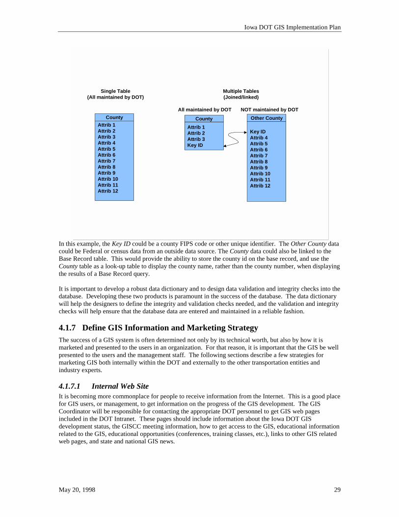
Iowa DOT GIS Implementation Plan
May 20, 1998 29
Single Table(All maintained by DOT)
CountyAttrib 1Attrib 2Attrib 3Attrib 4Attrib 5Attrib 6Attrib 7Attrib 8Attrib 9Attrib 10Attrib 11Attrib 12
Multiple Tables(Joined/linked)
CountyAttrib 1Attrib 2Attrib 3Key ID
Other County
Key IDAttrib 4Attrib 5Attrib 6Attrib 7Attrib 8Attrib 9Attrib 10Attrib 11Attrib 12
All maintained by DOT NOT maintained by DOT
In this example, the Key ID could be a county FIPS code or other unique identifier. The Other County data could be Federal or census data from an outside data source. The County data could also be linked to the Base Record table. This would provide the ability to store the county id on the base record, and use the County table as a look-up table to display the county name, rather than the county number, when displaying the results of a Base Record query. It is important to develop a robust data dictionary and to design data validation and integrity checks into the database. Developing these two products is paramount in the success of the database. The data dictionary will help the designers to define the integrity and validation checks needed, and the validation and integrity checks will help ensure that the database data are entered and maintained in a reliable fashion. 4.1.7 Define GIS Information and Marketing Strategy The success of a GIS system is often determined not only by its technical worth, but also by how it is marketed and presented to the users in an organization. For that reason, it is important that the GIS be well presented to the users and the management staff. The following sections describe a few strategies for marketing GIS both internally within the DOT and externally to the other transportation entities and industry experts.
4.1.7.1 Internal Web Site It is becoming more commonplace for people to receive information from the Internet. This is a good place for GIS users, or management, to get information on the progress of the GIS development. The GIS Coordinator will be responsible for contacting the appropriate DOT personnel to get GIS web pages included in the DOT Intranet. These pages should include information about the Iowa DOT GIS development status, the GISCC meeting information, how to get access to the GIS, educational information related to the GIS, educational opportunities (conferences, training classes, etc.), links to other GIS related web pages, and state and national GIS news.
Iowa DOT GIS Implementation Plan
May 20, 1998 30
4.1.7.2 Name the GIS Just as every human being is brought into the world and given a name, a GIS needs a similar identity so that people can refer to it and can feel comfortable with it as a part of their work environment. Since the term GIS can be very nebulous and is not very descriptive as to what the system actually contains or does, a more descriptive name is most desirable. It is important when naming the GIS that it is clear what boundaries the named entity encompasses. For example, the GDW and the management systems accessing the GDW may be given one name, but the crash analysis system may be given another name, even though they both use the GDW as a data source. The GIS Coordinator will be responsible for defining a process for the GIS to receive a name. This may include an internal contest, or a simple process of polling DOT personnel and coming up with a list from which the GISCC could select a name.
4.1.7.3 Conference Papers and Articles As the GIS develops into a production system, it is anticipated that DOT staff, ISU and CTRE personnel, and vendors will want to write articles or papers describing the GIS development and capabilities at Iowa DOT. This is an important part of the success of a GIS project and it generates excitement and support for the development of the system. The GIS Coordinator will be the primary contact for these articles and will help develop the written material if desired. The GIS Coordinator will also serve as a first edit process of the written materials to ensure its accuracy as it relates to the GIS.
4.1.7.4 External Marketing In addition to the conference papers and articles that will be developed about the Iowa DOT’s GIS, marketing to other agencies and users is important. It is necessary to make users aware of the data that are available and to take part in local and national data sharing efforts. The DOT will coordinate with the Iowa Geographic Information Council and the State GIS Coordinator to make the availability of our data better known throughout Iowa. 4.1.8 Design and Implementation of Linear Referencing System The inclusion of a linear referencing system (LRS) in the GIS is paramount in the success of the GIS with a department-wide, management system structure. The data in the different information systems within the DOT may all be spatially related, but it is important that they are spatially related based on a common datum. Geographic coordinates (latitude, longitude) can be used as a common datum, but most of the features tracked in a DOT fall along linear features such as roads or rail lines. It has been common practice to implement a LRS in DOTs within the US and in many Transportation Departments abroad. Software vendors have customized their software to address such data structures, and many research projects at both national and university levels have been undertaken to show the usefulness of a LRS and implementation strategies that could be employed in the development of a LRS. The Location and Linear Referencing System Team has completed its research and has created a report of recommendations for the implementation of a LRS at the Iowa DOT. It is the team’s anticipation that the GIS Coordinator and GISCC will take the report, develop a strategy for implementation, and finally implement a DOT-wide LRS. The Location and Linear Referencing System Team will oversee the implementation processes to ensure the recommendations are followed, but the entire management of the DOT must be supportive and proactive in the development and implementation of the new LRS. It will be the responsibility of the Location and Linear Referencing System Team, the GISCC, and the GIS Coordinator to facilitate the education of the DOT staff as to the importance of the LRS and to be the champions of the LRS development. Research will continue to ensure the use of the latest findings by the NHCRP, the FGDC, and other organizations developing GIS frameworks for transportation.
Iowa DOT GIS Implementation Plan
The DOT will develop a RFP to bring in a qualified consultant to help develop a practical LRS that is compatible with our GIS applications and field data capture processes. The contract cycle will be to make recommendations on the proposed implementation, to pilot the proposed methods and to eventually implement the LRS department wide and develop the final Base Record database and maintenance processes in Oracle.
An important part of the integration of the LRS into the GIS is the development of a supporting database. Current discussion has been started on the redesign of the base record database, but this effort will be best served by integrating it closely with the LRS development.
!May 20, 1998 31
4.1.9 Plan the Integration of GIS Related Applications Once the foundation of the GIS is started, it is important to look at the other applications that are being developed within the DOT. Digital Video Logging, the Highway Closure and Restriction System (HCRS), and the Records Management System (RMS) are three areas that have already been identified as having a GIS component or link. As the database and GIS are designed, these related systems should be considered, and conversely, those systems should also consider the incorporation of the GIS.
4.1.9.1 Digital Video Log Digital Video Logging could be accessed exclusively through the GIS. Most users who would want to access the video information would also find it very beneficial to access related database information about the road, bridge, or other highway feature that might be included in the GIS and shown on the video display. Many video log vendors have already integrated GIS into their systems, so the work required to integrate these two technologies may be minimal.
4.1.9.2 Highway Closure and Restriction System (HCRS) The highway data, or other data, in proximity of an incident is very useful in emergency decision making and potentially for making alternate routing decisions. On a map it might look appropriate to route traffic around incident-related congestion to a nearby road, but with the GIS, the analyst could quickly see that the road might be a small two-lane road with parking on each side, which effectively narrows it to one lane. Routing traffic from a four-lane road to this road would be almost more disastrous than the incident itself, since it could cause even more incidents. Utilizing GIS in this instance would provide additional information to the analyst and allow a more suitable route to be selected so as to avoid the original incident. The underlying data needed for a system such as the HCRS is the GIS data. It only makes sense to develop these two systems in parallel with each other so they are complimentary and not loosely related.
4.1.9.3 Records Management System (RMS) The concept of a transportation management and information system is to provide as many data as possible to the end user. If the user can query to a specific highway project or section of highway in the GIS, it would only be natural to access the documents that might exist in the DOT related to that project or highway segment. Most often the GIS is used as another query engine for a document management system like RMS. Of course, the primary RMS query engine would still be usable, but if the user entered the GIS to do a query, the user should not have to execute the same query in the RMS to find the documents. 4.1.10 Design and Build GIS/ITS Applications Many applications will be defined and requested as the GIS becomes functional. It is important to prioritize those application development projects, but also be sure they are integrated into a cohesive system. For instance, a Bridge Information System and a Pavement Information System should not have completely different query interfaces and access tools. The display of query results may be significantly different, but not the query interfaces that generate the results. Some of the current projects and how they integrate into the larger GIS and Transportation Management System development are listed below.
Iowa DOT GIS Implementation Plan
May 20, 1998 32
4.1.10.1 Non-NHS Pavement Management System The DOT has contracted with CTRE to develop a non-NHS pavement management system to augment the current NHS pavement management processes. This system is being developed with GIS capabilities and is utilizing a mile post linear referencing method. The integration of these data with the NHS pavement data must be considered and should be addressed as soon as possible. These data, along with other data in the Base Record database, will be helpful in developing the five-year program.
4.1.10.2 Statewide Coordinated GIS The DOT developed this project to facilitate the creation of the transportation management systems. The integration of the data is the first step in being able to develop a cross-division system. This project’s goals were to determine the data needed in a coordinated GIS, integrate the DOT’s data into a single GIS interface, to develop a custom interface for accessing the data, and to train the users in the use of the new system. It may be desirable that this system develop into the future transportation management systems and the base for the ITS projects that are under development at the DOT. 4.2 On-going Tasks In the development of the larger GIS organization and data structure, several smaller analytical GIS projects may be identified or will continue to be developed. These projects include efforts such as the GIS-ALAS project, the Access Mapping project, the wetlands mapping and identification efforts, and the GISCC support contract tasks. While these projects may be viewed as separate or unrelated to the development of the larger GIS development, the GISCC and GIS Coordinator should facilitate the integration of these systems, as it is appropriate, into the larger GIS scheme. By doing this, the sharing of data from the analytical tools, and the institutionalization of the analytical tools will become less difficult. 4.3 GIS Software Standards The GISCC has determined that it is not beneficial to tie the department to one standard GIS package for all GIS applications within the DOT. It is necessary, however, to standardize on a package for a group of users that all need the same basic capabilities or data access. An example might be the users of the new Transportation Management Systems. Custom applications will be developed for these systems and it is not desirable to develop those applications on multiple GIS platforms. In previous sections the system architecture was described. Three main groups of software will be required to support the users in that architecture. These groups are: • the GIS desktop users’ (GIS users) software, • the GIS maintenance users’ software, • and the relational database management system (to support the GDW). 4.3.1 Desktop GIS Software This software will be utilized on all the general GIS users’ desktops. It is most likely that the product will not be utilized alone, and that some custom application will exist on every user’s desktop. This fact translates into a requirement to have a software package that is easily customized. Additionally, since the analytical seats may utilize whatever software that is most appropriate for a particular analysis, and that the outside GIS data sources may come into the DOT in a variety of formats and projections, it is desired that this software be able to handle all these data formats. Most GIS products can handle the different data sources through a translation, but support and training for such an environment can be difficult. It is desired that the product read these formats directly, without translation.
Iowa DOT GIS Implementation Plan
May 20, 1998 33
Currently, GeoMedia is the only tool that reads Intergraph file formats and ESRI’s file formats without translation. The product is scheduled to have the ability to read MapInfo’s file formats by the middle of 1998 and currently reads Oracle’s spatial data storage formats. Since the other functions within GeoMedia, MapInfo, and ArcView were all comparable, the GIS Coordinator recommended the use of GeoMedia for the desktop GIS software. This product will be customized and used in some of the projects currently underway at CTRE. A more detailed explanation of this recommendation is included in the appendix of this document. 4.3.2 GIS Maintenance Software The software used to maintain the GIS base map data must be easily used and have quick response for the personnel assigned to maintain the map. The Office of Transportation Data will be responsible for maintaining all the GIS map data and their associated base attribution. Some of these data, such as county boundaries and Regional Planning Affiliation boundaries, will be developed once and will require very little future modification. Other data, such as the highway network, will require extensive yearly updates. The GIS software must accommodate both types of data and also have tools to support the creation of analytical models such as dynamic segmentation networks. Due to Iowa DOT’s dependence on MicroStation, in addition to the previous requirements, the GIS Coordinator recommended the use of Intergraph’s Modular GIS Environment (MGE) to aid in the maintenance of the data. In situations where this tools is undesirable due to performance or complexity, custom maintenance applications will be developed to aid in the maintenance of the data. The IP Steering Committee accepted this recommendation and additional training and implementation efforts that utilize this software will continue. 4.3.3 Relational Database Management System Software The relational database management system (RDBMS) software is the most critical part of the GDW. This software will store all the attribute information contained in the GIS, and could potentially store all the spatial information in lieu of using the MGE software’s MicroStation design files. The GIS Coordinator, with the approval of the GISCC, approached the IP Steering Committee with the recommendation to use Oracle’s relational database management system for the GIS. This recommendation was approved and further training and software implementation of the current Oracle licenses will continue. The memorandum explaining this recommendation is attached in the appendix of this document. 4.4 GIS Hardware Standards The GIS hardware will conform to the standards set forth by the IP Steering Committee for the DOT. All the hardware will be Intel-based and capable of running Microsoft Windows NT. The basic minimum configuration of the desktop computer for GIS is shown below: • Pentium Processor (120 MHz or better) • 32 MG RAM • Ethernet Network Card No additional specification is given since hardware specs and requirements change so rapidly that it is better to contact the GIS Coordinator or GIS Support prior to purchasing any hardware for GIS. 4.5 Data Distribution Data distribution is a primary concern for the DOT since much of the data the DOT develops needs to be utilized by entities outside the DOT headquarters complex in Ames. This includes field personnel, cities,
Iowa DOT GIS Implementation Plan
May 20, 1998 34
counties and other state agencies. CDs have been considered the best data distribution method for projects currently underway, but as the Internet and the DOT LAN/WAN mature, these methods may also be considered as primary methods of data distribution. The format of the data created must also be addressed. The DOT will be creating Oracle database tables and MicroStation design files that are linked together to form a GIS in the MGE structure. This format will be read by MGE or GeoMedia and exported to other formats for other products such as ArcView or MapInfo. The support for this task could be substantial and may require additional staff if many groups start using the DOT’s data or if different formats are required. The OpenGIS Consortium (OGC) is a national organization of vendors and industry specialists that is striving to have a more open format for sharing data between vendors. These efforts may also help alleviate some the DOT’s data sharing issues. 4.6 Organization of GIS Budgets The organizational structure of the DOT usually requires that each division requiring software handle their own software budgets for desktop applications. The development of GIS applications is not always equitable in this environment. If it is determined that a GIS application be developed that will help not only the division requesting the application, but also the entire department, then the individual division should not bear the cost for the application alone. This is the case of the Transportation Management Systems and other related GIS components. In addition to the applications, departmental software may need to be acquired (Oracle) and departmental support may be needed. The GIS Coordinator will identify and address these issues as they arise. 4.7 Implementation Summary and Timeline Each of the tasks identified in Chapter 4 help achieve the goals in Chapter 3. For example, the tasks of defining GIS software standards, defining the GIS system architecture, designing the GIS database, identifying and training resources, and developing metadata all contribute to the completion of the goal of implementing the Statewide Coordinated GIS project. The development of the LRS will enhance that project as a long-term goal and will allow for better integration with the ITS projects. The table below helps to better identify which tasks help achieve which goals. The “I” shows which tasks help complete the initial implementation of a goal, and the “F” shows which tasks will enhance the initial implementation in the future or help complete a long-term goal.
GIS Goals
Identified Tasks (Completion Date) Es
tabl
ish
GD
W
Met
adat
a A
vaila
ble
to
Use
rs
Impl
emen
t Sta
tew
ide
Coo
rdin
ated
GIS
Impl
emen
t GIS
/ALA
S
Prov
ide
Dat
a to
Ext
erna
l A
genc
ies
Inte
grat
e D
igita
l V
ideo
L o
ggin
g Im
plem
ent L
RS
into
the
GIS
Dev
elop
Rou
ting
App
licat
ion
Inte
grat
e an
ITS
Proj
ect
Fully
Tra
ined
GIS
Pe
rson
nel
Impr
ove
Bas
e M
ap
Acc
urac
y
Cre
ate
New
GIS
A
pplic
atio
ns
Establish Base Record Download Cycle into Oracle (August, 1998)
I I I I
Define Desired GIS Applications (August, 1998)
I
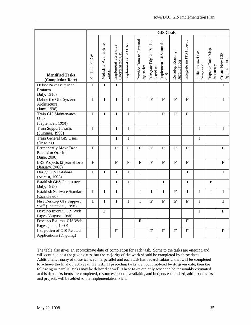
Iowa DOT GIS Implementation Plan
May 20, 1998 35
GIS Goals
Identified Tasks (Completion Date) Es
tabl
ish
GD
W
Met
adat
a A
vaila
ble
to
Use
rs
Impl
emen
t Sta
tew
ide
Coo
rdin
ated
GIS
Impl
emen
t GIS
/ALA
S
Prov
ide
Dat
a to
Ext
erna
l A
genc
ies
Inte
grat
e D
igita
l V
ideo
L o
ggin
g Im
plem
ent L
RS
into
the
GIS
Dev
elop
Rou
ting
App
licat
ion
Inte
grat
e an
ITS
Proj
ect
Fully
Tra
ined
GIS
Pe
rson
nel
Impr
ove
Bas
e M
ap
Acc
urac
y
Cre
ate
New
GIS
A
pplic
atio
ns
Define Necessary Map Features (July, 1998)
I I I I I
Define the GIS System Architecture (June, 1998)
I I I I I F F F F I
Train GIS Maintenance Users (September, 1998)
I I I I I F F F I
Train Support Teams (Summer, 1998)
I I I I I I
Train General GIS Users (Ongoing)
I I I
Permanently Move Base Record to Oracle (June, 2000)
F F F F F F F F F
LRS Projects (2 year effort) (January, 2000)
F F F F F F F F F
Design GIS Database (August, 1998)
I I I I I I I
Establish GPS Committee (July, 1998)
I I I I I F
Establish Software Standard (Completed)
I I I I I I F I I I I
Hire Desktop GIS Support Staff (September, 1998)
I I I I I F F F F I I
Develop Internal GIS Web Pages (August, 1998)
F I F
Develop External GIS Web Pages (June, 1999)
F F
Integration of GIS Related Applications (Ongoing)
F F F F F F
The table also gives an approximate date of completion for each task. Some to the tasks are ongoing and will continue past the given dates, but the majority of the work should be completed by these dates. Additionally, many of these tasks run in parallel and each task has several subtasks that will be completed to achieve the final objectives of the task. If preceding tasks are not completed by its given date, then the following or parallel tasks may be delayed as well. These tasks are only what can be reasonably estimated at this time. As items are completed, resources become available, and budgets established, additional tasks and projects will be added to the Implementation Plan.
Iowa DOT GIS Implementation Plan
May 20, 1998 36
5 Conclusion 5.1 Implications for the Five Components of GIS The five components of GIS were defined in Chapter 1. The conclusion will review these components and show that the implementation plan addresses the components effectively. 5.1.1 Organizational Policies/Procedures The following basic policies and procedures were established in the implementation plan: • The DOT will develop and implement a Department-wide Linear Referencing System. • The basic GIS architecture for implementation of hardware and software. • The method for developing timely and effective maintenance procedures for the data was addressed. • Development of new GIS and related applications will be focused around the use of the products
approved by the Information Processing Steering Committee where possible. These products are Oracle, MGE, and GeoMedia.
• Resource categories were identified with specific tasks defined for each category. • Coordinator will help establish centralized budgets for departmental GIS expenditures • Creation of the GPS Committee A consideration for the future is the location of GIS as a function within the DOT. GIS is a technology that, by its nature, transcends many divisional boundaries. For that reason, consideration should be given to the budgeting processes for GIS and where the responsibility for development of the system resides. A single divisional budget should not be responsible for the entire Department’s GIS expenditures, and it is desirable to have the budget centralized for ease of tracking. 5.1.2 Personnel The Implementation Plan identifies four primary groups of personnel for development, support and use of the GIS, three identified in the Strategic Plan and one additional group identified in the Implementation Plan. Those groups are shown below. The four groups are subdivided into groupings that fit into the structure of Iowa DOT’s organization. Primary GIS Groups Organizational Responsibility in DOT 1. GIS Maintenance Staff
• GIS Development Specialists • GIS Data Maintenance Specialists
Primarily Office of Transportation Data
2. GIS Support Staff • GIS Coordinator • Desktop GIS Support (Business Workflows) • Desktop GIS Support (System Support) • Database Administrator
GIS Coordinator New GIS Position Database Administrator Office of Data Services
3. GIS Application Developers • GIS Software Developers • GIS Database Modelers
New GIS Position Database Administrator Office of Data Services
4. GIS Users • General GIS Users • GIS Analysis Users
All Divisions within the DOT
Iowa DOT GIS Implementation Plan
May 20, 1998 37
5.1.2.1 Training Needs The GIS training at the DOT should be specific for the GIS Support and Application Developers, the GIS Maintenance Staff, and the General GIS Users. Each group will require a slightly different focus during their training. The specific training requirements for the GIS personnel were identified in Chapter 4. Training was identified at all levels, although the specific courses and dates will be identified in the future.
5.1.2.2 GIS Education and Marketing Before GIS training on specific hardware and software can occur, it is necessary to educate the users in the general use of GIS so they understand the necessity and usefulness of the GIS and its related applications and to inform them of its availability. The Implementation Plan addresses a strategy for providing this education and making the GIS known to the users through the GIS Information and Marketing Strategy. The DOT will also work closely with the efforts of the State GIS Coordinator in development of the State GIS Clearinghouse. This effort will help market the DOT’s data and point out the fact that the GIS data is available to the public. 5.1.3 Data The GIS capable data that are currently maintained by the DOT in the Office of Transportation Data and in all the other divisions of the DOT will be considered part of the GIS over time. An initial set of map features and attributes will be identified for the first phase of the GIS implementation, but eventually any data that can be integrated into the GIS environment will be physically placed into the GDW or virtually linked into the GDW. In addition, the DOT will determine what data from outside sources should be contained in the GDW and although DOT personnel will not maintain those data, it will be available for the DOT GIS users. All the data posted in the GDW will need to have metadata developed. The metadata will have a user interface that will display the data to the end user. The data update cycles will be reviewed to determine that need to update the GDW in a timely fashion. It is important that the data based on user needs. The GIS Database that stores the map features will go through a design stage where a logical and physical database model is developed. 5.1.4 Hardware The Implementation Plan does not recommend specific hardware or specify hardware requirements for the use of GIS. The dynamic nature of the software and technology will quickly make such information antiquated and can cause confusion to individuals reading this Plan in the future. In general the following is required to run the desktop GIS software: • Pentium Processor (120 MHz or better) • 32 MG RAM • Ethernet Network Card The development of the GIS will follow the direction set by the IP Steering Committee for use of Intel-based hardware capable of running Windows NT. In addition to the end user requirements, the general architecture of the GIS environment is fully explained and provides the DOT direction in the design and procurement of necessary hardware.
Iowa DOT GIS Implementation Plan
May 20, 1998 38
5.1.5 Software The GIS Coordinator has spent significant time evaluating and gaining consensus on which software packages should be utilized to construct the GIS infrastructure at the DOT. The packages that were determined as a “standard” are: • Oracle Relational Database Management for the GDW relational database software, • Intergraph Modular GIS Environment (MGE) for the maintenance software, and • Intergraph GeoMedia for the desktop GIS software. All this software supports the GIS architecture proposed in the Implementation Plan and works in the standard environment identified by the IP Steering Committee (Windows NT and Intel PCs). 5.2 Implementation Plan Usage Implementation of any large system is a complex and difficult process, and needs to be carefully orchestrated. This Implementation Plan does not address every topic or complexity that will occur in the implementation of GIS at Iowa DOT. For instance, the issues of budgets and personnel rollover are not addressed, but it does identify the necessary steps and the direction that should be taken for successful implementation. The careful consideration of the topics presented in this plan will guide the process and will aid the DOT in a successful GIS implementation. 5.3 Implementation Plan Cost While it is difficult to identify the exact costs of developing the GIS, the following paragraphs describe the areas where expenditures must occur. 5.3.1 Staff Costs The addition of the Desktop GIS Support (Business Workflow) position will add to the support costs of the GIS. This position is needed, however, to support the users in the daily use of the GIS and will aid in the institutionalization of the GIS. 5.3.2 Staff Training The development of the GIS will create the need for additional training at all levels of the DOT. The end users and support teams will require technical training to use and support the GIS. The application development must be done on new Microsoft Windows-based tools that are new to the DOT support teams. As a result, training will be required on those software packages as well. 5.3.3 Hardware Costs Two different types of computer hardware are needed to support the GIS; these are the users’ desktop computers and the GIS servers. The desktop computers will only need replaced if the hardware is unable to support the applications. A new server will be needed to support the numerous users and the large amount of data that is being developed and acquired from outside entities. This new server will augment the existing GIS server that is under-powered to support the numerous users that will access the GIS data. The existing server will be utilized as a GIS web server once the new server is acquired and the user load is shifted to the new server. The LAN and WAN currently are being developed for many uses in the DOT. This equipment will be very important in the success of the GIS. The GIS data structures should be considered when design and optimization of the network is being discussed.
Iowa DOT GIS Implementation Plan
May 20, 1998 39
5.3.4 Software Costs The software costs will be primarily associated with the purchase of GeoMedia and Oracle licenses. Minimal expenditures to acquire a few additional licenses of the GIS data maintenance software (MGE and MGSM) will be required as more users are added to that group. Some costs will be realized as new products are reviewed The other area of cost associated with the software is the maintenance expense. This expense is necessary to ensure good support of the software from the vendor and that the DOT receives software upgrades as they become available. 5.3.5 Consultative Services Costs The DOT support teams and users will continue to become more educated in the configuration and use of the GIS. It is often beneficial, in order to expedite the development of applications or to obtain a special skill set, to hire consultants to aid in the development of a GIS. CTRE has supported the DOT in the development of GIS pilot projects and by providing expertise while the DOT was in the early stages of GIS development. It is reasonable to expect that CTRE’s role will be smaller in the future, but that they will still aid in the research of new technologies and in new GIS efforts. Application development consultants will also provide needed expertise in the development of custom GIS applications related to the Transportation Management Systems and the development of web-base GIS solutions. Software specialists from specific vendors or their partners also can provide valuable performance and configuration guidance. Regardless of the services provided, a detailed scope of work and contract will be generated to ensure that the consultant performs as desired by the DOT and provides useful services.

Iowa DOT GIS Implementation Plan
May 20, 1998 A-1
Appendix A
Approved Software Recommendations
Iowa DOT GIS Implementation Plan
May 20, 1998 A-2
GIS Software Memorandum To: IP Steering Committee Members From: Bill Schuman, GIS Coordinator Subject: GIS Software Recommendations As I discussed in the previous IP Steering Committee Meeting, I have identified three tiers of software needed for the GIS at Iowa DOT: the relational database software, the maintenance GIS product, and the desktop GIS software (see appended slide). A recommendation has already been presented to the IP Steering Committee regarding the relational database software. Oracle Corporation’s product suite was recommended and accepted. This document addresses the recommendations on the maintenance and desktop GIS products. GIS Maintenance Software Three software packages were considered for this software tier. The GISCC and GIS Technical Users Group is recommending Intergraph’s MGE product. The reasoning behind that decision is given below. Modular GIS Environment (MGE) – (Intergraph Corporation) Currently, Iowa DOT owns Intergraph’s Modular GIS Environment (MGE) software to support its mapping efforts in the Office of Transportation Data. This product is used in many DOTs and larger mapping entities. Some internal testing has been done with this software to be sure it is functional with the current data and that it will meet our needs. Since MGE is based on the MicroStation product, which is the DOT’s primary CAD software, I feel that using MGE to continue our GIS development is a logical choice. The MGE suite contains a software module called MGE Segment Manager (MGSM). This product will allow us to model the road network to support dynamic segmentation. This capability is desired for our future use of a Linear Referencing System (LRS) with the Base Record information in GIS. (Cost - ~$3000 for additional MGSM software.) GeoGraphics – (Bentley Systems) One other viable GIS product is built on MicroStation, GeoGraphics. While this software is a satisfactory product for basic GIS maintenance and analysis, it does not currently contain the needed capability to support dynamic segmentation. It would also require the DOT to purchase new software. Arc/Info - (Environmental Systems Research Institute, Inc.) The other major contender for the GIS maintenance software is Environment Systems Research Institute’s (ESRI) Arc/Info product. This product is well accepted in the GIS industry and has powerful analysis tools. Arc/Info will also support dynamic segmentation in its network modeling. The difficulty in using this product is the necessity to translate our current map files into a new format for use in the GIS. We would then have to either start maintaining the map in Arc/Info, or “retranslate” the maps after any linework updates. While the translation process is better now than it has been, this would still create huge learning curves, would require the redesign of our mapping procedures, and would require the DOT to purchase new software. (Large cost due to reengineering Transportation Data’s workflows around a non-MicroStation product and DOT learning curve.) Desktop GIS Software Three software packages were considered for the desktop GIS tier. Based on my findings in using each of the products and the workflow desired within the DOT, I am recommending Intergraph’s GeoMedia product
Iowa DOT GIS Implementation Plan
May 20, 1998 A-3
for our desktop mapping software. The reasons for my decision are given below and a matrix of my findings is attached to this memorandum. Please note that this is the software that will be used for the general GIS user, and will not be the only GIS desktop application that will be used in the DOT. As specific analytical needs arise, other packages can be utilized, but this platform will be used for the future GIS related transportation management system applications. This software will also be the GIS software used to integrate related systems within the GIS environment, such as the Records Management System, and to address some of the ISTEA Transportation Management System applications. GeoMedia - (Intergraph Corporation) GeoMedia has two features that make it appealing to a large organization with many data sources, such as Iowa DOT. First, it reads several different GIS software formats. Currently, GeoMedia will read ESRI’s Arc/Info data format, Intergraph’s MGE and MGSM formats, Oracle’s Spatial Data Engine format, and is promised to read MapInfo’s and ArcView’s file formats. This fits well with the desires of the GISCC to allow the use of other GIS products as needs arise, since any new data generated from analysis in most of the other products could be read in GeoMedia without translation. The second feature, but perhaps the more important one, is GeoMedia’s ability to handle map projection transformations dynamically. The DOT currently plans on using a Lambert Conformal Conic projection, the Iowa Department of Natural Resources (DNR) uses a Universal Transverse Mercator projection, and the counties may be using a State Plane coordinate system projection. If we choose not to use GeoMedia and wanted to pull data into the DOT from the DNR or counties to display with our map information, we would be required to do a projection transformation each time we get an update. This would be a training and software issue for the DOT, but it can be avoided by using GeoMedia. Additionally, GeoMedia is based on object-oriented (OO) technology and can be tightly integrated with the latest application customization and creation tools, such as Visual Basic and PowerBuilder. Iowa State’s Center for Transportation Research and Education (CTRE) has done some initial testing of this technology and found a significant decrease in the amount of code needed to generate applications. Using a tool like Visual Basic would be better than a proprietary tool, since the support teams could leverage the tool for other application needs, not just the GIS environment’s needs. This is a new technology, however, and a learning curve will have to be overcome. This curve would exist to some extend in the DOT regardless of the product selected, since the support teams have never used GIS products. The graphical user interface (GUI) in GeoMedia seemed to be somewhat more intuitive than the other products. While none of the products were difficult to use, the spatial analysis portion of the product was less complex and easier to understand. MapInfo Professional - (MapInfo Corporation) MapInfo was the second GIS application that I reviewed. It has a great set of thematic mapping tools for displaying data distribution on a map. Based on my review of what CTRE has done with MapInfo it has shown to be highly customizable, but requires the use of a specific language called MapBasic. Intergraph has provided a direct translation from MGE files to MapInfo, so getting from the maintenance environment to the desktop would be straightforward, but the projection transformations would still need to be addressed prior to translation into MapInfo. MapInfo also does not have a dynamic segmentation capability, and therefore would require inefficient preprocessing to display any information we may have available in a linear referencing model. ArcView - (Environmental Systems Research Institute, Inc.) The third package I reviewed, ArcView, is a great software package for GIS and has excellent map plotting tools; but due to limited ability to do dynamic projection transformations, it is less flexible than GeoMedia when using data from many sources. ArcView also has an extension called the CAD Reader that allows the use of MGE files that are in the same projection as the active project. While this will be useful for our users that may choose ArcView for specific analysis projects, it is not the direction we want to utilize for our
Iowa DOT GIS Implementation Plan
May 20, 1998 A-4
general GIS and Transportation Management Systems. Again, like the other products, ArcView is very customizable, but the customization requires the use of a proprietary language called Avenue. Using Avenue, or MapBasic for that matter, would create more work for our application support group, since it would be yet another language for our support teams to master. In addition to ESRI’s ArcView product, I researched the capabilities of their Map Objects toolbox. While it did give very good object-oriented customization capabilities to the GIS interface, all of the application had to be written from scratch. Very little “productization” existed in Map Objects, so a complete application design, development, and testing process would have to be taken with this product, thus increasing the start-up time. Others In addition to the previously mentioned software, I also reviewed Caliper Corporation’s GIS offerings. While I did not specifically use their Maptitude or TransCAD software, the industry acceptance of these packages has been more in the specific analysis applications and less in the general GIS user workflows. TransCAD has several good transportation analysis tools, but is not considered one of the better GIS data integration tools on the market. We will utilize this software in the DOT, but not as the general GIS Desktop software.
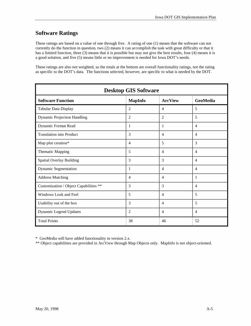
Iowa DOT GIS Implementation Plan
May 20, 1998 A-5
Software Ratings These ratings are based on a value of one through five. A rating of one (1) means that the software can not currently do the function in question, two (2) means it can accomplish the task with great difficulty or that it has a limited function, three (3) means that it is possible but may not give the best results, four (4) means it is a good solution, and five (5) means little or no improvement is needed for Iowa DOT’s needs. These ratings are also not weighted, so the totals at the bottom are overall functionality ratings, not the rating as specific to the DOT’s data. The functions selected, however, are specific to what is needed by the DOT.
Desktop GIS Software
Software Function
MapInfo
ArcView
GeoMedia
Tabular Data Display 2 4 5
Dynamic Projection Handling 2 2 5
Dynamic Format Read 1 1 4
Translation into Product 3 4 4
Map plot creation* 4 5 3
Thematic Mapping 5 4 4
Spatial Overlay Building 3 3 4
Dynamic Segmentation 1 4 4
Address Matching 4 4 1
Customization / Object Capabilities ** 3 3 4
Windows Look and Feel 5 4 5
Usability out of the box 3 4 5
Dynamic Legend Updates 2 4 4
Total Points 38 46 52
* GeoMedia will have added functionality in version 2.x. ** Object capabilities are provided in ArcView through Map Objects only. MapInfo is not object-oriented.
Iowa DOT GIS Implementation Plan
May 20, 1998 A-6
Database Software Memorandum To: IP Steering Committee From: GIS Coordinator and GIS-CC Subject: Definition of a standard relational database for GIS The Iowa DOT GIS Coordination Committee (GIS-CC) has been moving forward on its efforts to move GIS into the mainstream at the DOT. Now that the GIS Technical Specialist and GIS Coordinator roles have been filled, it is important to determine, without doubt, the relational database that will be used to support the GIS. The importance for defining the database of choice is to ensure that the training obtained by the Technical Specialist and other support staff is not wasted, that any custom applications that are developed as part of the GIS are developed using the chosen database, and that the GIS software tools purchased are compatible with the relational database. It is the recommendation of the GIS Coordinator and the GIS-CC that Oracle be formally adopted as the official relational database software for GIS at Iowa DOT. This will not preclude the use of other databases for specific GIS applications, but will be the software platform for all the GIS maintenance and the storage facility for the enterprise GIS data. Iowa DOT has been using Oracle as a test database for some of its GIS projects. The remainder of the projects have been using the GIS products’ proprietary formats to store data. To this point, Oracle was not ready to be implemented in any production workflows. The Coordinator is now ready to begin development of the “Base Map Features” for the GIS. It is important to establish the GIS database, so those features can be placed in the database when the feature design is complete. The DOT has purchased an Oracle server and several months of software maintenance so that Oracle could be supported and upgraded. Substantial cost has gone into establishing Oracle already for the DOT’s map publishing and cartography efforts. Additional software licenses will be required when the database goes into production, but the base software is in place.
Iowa DOT GIS Implementation Plan
May 20, 1998 A-7
Oracle’s relational database products are quite good and are used by many organizations around the world. Oracle is a stable company and continues to keep up with the demands of the database industry. The other positive aspects of the Oracle database products are listed below:
• GIS Support - Oracle has worked with the two main GIS software vendors (ESRI and Intergraph) to create closer links to their software. In addition, Oracle supports Spatial Data Engines through a module they call the Spatial Data Option (SDO). GIS vendors have linked their software to this database engine as a storage method for GIS data. While we are unsure of the role SDO will play in the Iowa DOT GIS at this time, it is a good option that increases data access performance.
• Enterprise Support - If, in the future, Iowa DOT determines that it will use a relational database for data outside the GIS realm, then the DOT would be able to utilize the expertise already gained while developing the GIS databases. Oracle is powerful enough to support very large databases and could support the DOT in non-GIS areas if desired. As the database use grows with GIS and other applications, additional high-end products can be added to better handle the data needs for the DOT.
• Transportation Modules / Expertise - Many consultants and vendors have built transportation modules on Oracle or have very strong Oracle expertise. This would keep costs down for the DOT since we could leverage that expertise in developing our GIS applications. In addition, Oracle has its own transportation management products that might be further explored should the need arise.
• Database Access - In addition to using Oracle tools for accessing the database, most vendors have developed access methods to use Oracle’s database structure. This includes such products as ODBC drivers, Intergraph’s Relational Interface System (RIS), and other product specific drivers. This leaves the DOT more flexibility in choosing end-user applications that utilize a database.
Although the benefits of using Oracle are substantial, some other points should be considered. As with most software products, the more powerful they are, the more complex they are. Oracle is more complex than some of the lower end databases. This complexity must be overcome with adequate training, since we will be required to use a more powerful database to handle the potentially large number of users that will be using the GIS. The DOT has other database products in place for many of its database needs. While these products serve the DOT quite well, they are not databases that facilitate the use of GIS. The most popular GIS products do not have interfaces with these existing database products and, in fact, one vendor has dropped its support of DB2.

Iowa DOT GIS Implementation Plan
May 20, 1998 A-8
Oracle is not a database that can be distributed on a CD very easily or cheaply. The use of the network, rather than CDROM, is a good alternative for distributing the data, but may not be feasible for all users. In most instances, however, distribution of data on a CD can be accomplished by using less powerful or proprietary database formats. This is acceptable since the data on the CD will be a snapshot of the database, will not be updateable, and a CD is usually accessed by only a single user at any one time. The GIS-CC would like to have the support of the IP Steering Committee and individuals concerned with the purchase and support of the software proposed in this recommendation. A written approval to proceed with this recommendation would be appreciated. The GIS Coordinator will be available to answer any questions that might arise as a result of this recommendation.