Embed Size (px)
Citation preview

Ipswich Soil Management Guidelines

Table of contents
Ipswich Soil Management Guidelines
Section 1
Section 2
Section 3
1. Introduction .................................................................................. 11.1 Purpose of guidelines ............................................................................................................ 11.2 Background and area covered ........................................................................................... 1
2. How to use the guidelines ........................................................... 22.1 Using the guidelines .............................................................................................................. 22.2 Identify soil type using the mapping ............................................................................... 22.3 Soil observations and testing ............................................................................................. 43. Soil Type Key ................................................................................. 9
4. Soil Type Confirmation and Review ......................................... 104.1 Vertosols (Cracking clay soils) ..........................................................................................104.2 Hydrosols (Waterlogged soils) .........................................................................................144.3 Kurosols (Acidic texture contrast soils) .........................................................................174.4 Sodosols (Sodic, alkaline, texture contrast soils) ......................................................214.5 Chromosols (Neutral texture contrast soils) ...............................................................254.6 Dermosols (Non-cracking clay to clay loam soils) ...................................................294.7 Kandosols (Sandy textured soils) ....................................................................................334.8 Stratic Rudosols (Deep layered alluvial soils) .............................................................364.9 Leptic Rudosols and Tenosols (Shallow stony soils) ................................................39
5. General Soil Management Principles ....................................... 425.1 Erosion, drainage and sediment control requirements ..........................................425.2 Soil handling techniques and rehabilitation ...............................................................43
6. Glossary ....................................................................................... 44
7. References ................................................................................... 48Produced and published by Amec Foster Wheeler, Ipswich City Council and Ipswich Rivers Improvement Trust.
DisclaimerThis publication is made available for information purposes only and on the basis that users remain responsible for satisfying themselves as to its accuracy, completeness and currency. All images remain property of the original author and are used purely for educational purposes only and may not be reproduced without further approval. The publisher accepts no liability and (including liability for negligence) for any loss or damage (including consequential or indirect loss or damage) that may be incurred as a result of any person’s use of this publication.
Ipswich Soil Management Guidelines Section 1
1
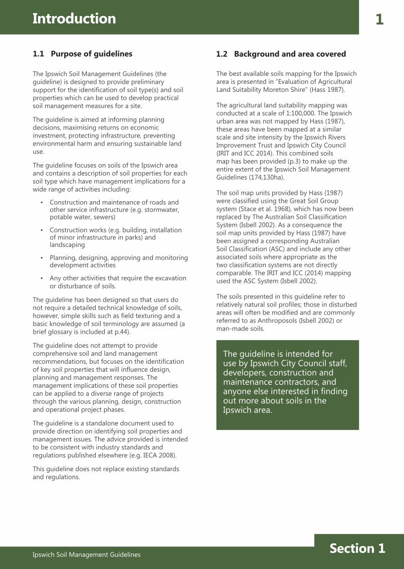
The guideline is intended for use by Ipswich City Council staff, developers, construction and maintenance contractors, and anyone else interested in finding out more about soils in the Ipswich area.
Introduction
1.1 Purpose of guidelines 1.2 Background and area covered
The Ipswich Soil Management Guidelines (the guideline) is designed to provide preliminary support for the identification of soil type(s) and soil properties which can be used to develop practical soil management measures for a site.
The guideline is aimed at informing planning decisions, maximising returns on economic investment, protecting infrastructure, preventing environmental harm and ensuring sustainable land use.
The guideline focuses on soils of the Ipswich area and contains a description of soil properties for each soil type which have management implications for a wide range of activities including:
• Construction and maintenance of roads and other service infrastructure (e.g. stormwater, potable water, sewers)
• Construction works (e.g. building, installation of minor infrastructure in parks) and landscaping
• Planning, designing, approving and monitoring development activities
• Any other activities that require the excavation or disturbance of soils.
The guideline has been designed so that users do not require a detailed technical knowledge of soils, however, simple skills such as field texturing and a basic knowledge of soil terminology are assumed (a brief glossary is included at p.44).
The guideline does not attempt to provide comprehensive soil and land management recommendations, but focuses on the identification of key soil properties that will influence design, planning and management responses. The management implications of these soil properties can be applied to a diverse range of projects through the various planning, design, construction and operational project phases.
The guideline is a standalone document used to provide direction on identifying soil properties and management issues. The advice provided is intended to be consistent with industry standards and regulations published elsewhere (e.g. IECA 2008).
This guideline does not replace existing standards and regulations.
The best available soils mapping for the Ipswich area is presented in “Evaluation of Agricultural Land Suitability Moreton Shire” (Hass 1987).
The agricultural land suitability mapping was conducted at a scale of 1:100,000. The Ipswich urban area was not mapped by Hass (1987), these areas have been mapped at a similar scale and site intensity by the Ipswich Rivers Improvement Trust and Ipswich City Council (IRIT and ICC 2014). This combined soils map has been provided (p.3) to make up the entire extent of the Ipswich Soil Management Guidelines (174,130ha).
The soil map units provided by Hass (1987) were classified using the Great Soil Group system (Stace et al. 1968), which has now been replaced by The Australian Soil Classification System (Isbell 2002). As a consequence the soil map units provided by Hass (1987) have been assigned a corresponding Australian Soil Classification (ASC) and include any other associated soils where appropriate as the two classification systems are not directly comparable. The IRIT and ICC (2014) mapping used the ASC System (Isbell 2002).
The soils presented in this guideline refer to relatively natural soil profiles; those in disturbed areas will often be modified and are commonly referred to as Anthroposols (Isbell 2002) or man-made soils.

2
Ipswich Soil Management GuidelinesSection 2
The use of this guideline is based on four steps:
1. Identify soil type using the mapping (p. 3)
Use the soil maps on page 3 to narrow down the likely soils present.
2. Conduct soil observations and testing (p. 4-8)
Undertake site obversations/tests on a soil exposure or core (if available) and use the key provided at page 9 to identify the most likely soil type from those mapped.
3. Soil type confirmation (p. 10-41)
Go to the relevant soil type and review the photos and information to confirm soil type.
4. Review soil properties and management procedures
Key soil properties are presented for each soil type, including information on how the soil responds to human activities or environmental conditions and relevant management responses/measures.
General soil management principles are presented on pages 42-43. These principles are applicable to all soil types.
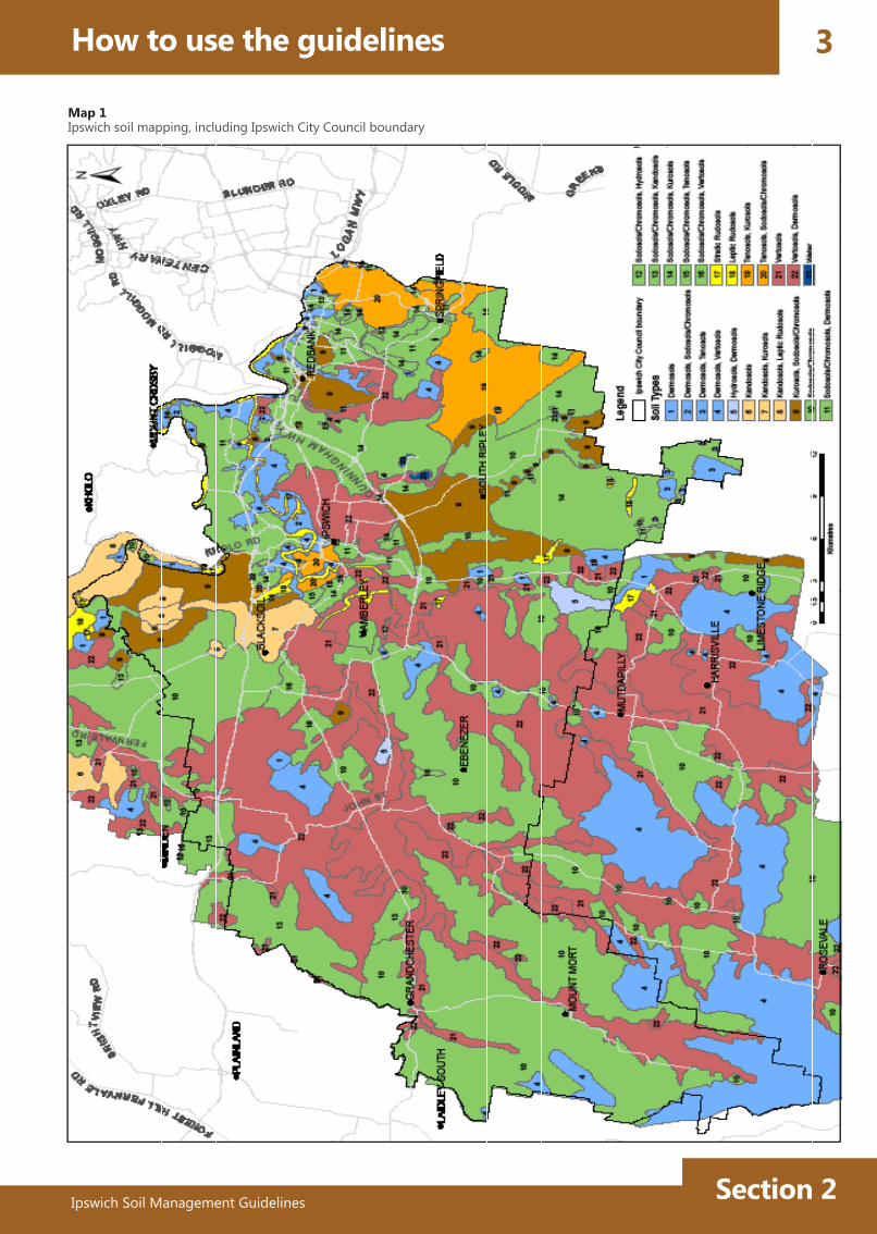
There are nine soil types (Australian Soil Classification System, (Isbell 2002) occurring in the Ipswich area which are presented in this guideline. Use the soil type mapping presented on page 3 to identify the likely soil type at your site.
For each of the 22 mapping units identified by Hass (1987) and IRIT and ICC (2014), the dominant and sub-dominant soil types are listed (Map 1). Natural variation of the soils means there are limitations of the mapping at this scale, and as a result it is not possible to cover all possibilities in each mapping unit.
How to use the guidelines
2.1 Using the guideline 2.2 Identify soil type using the mapping
Section 2Ipswich Soil Management Guidelines
3
Map 1Ipswich soil mapping, including Ipswich City Council boundary
How to use the guidelines

Ipswich Soil Management GuidelinesSection 2
2.3 Soil observations and testing
1. Surface soilAccumulation of organic matter causes darker colour
2. Subsurface soilLess organic matter, paler colour and may have less clay than surface soil. Note: Pale subsurface horizons are not present in all soils.
1
2
3 3. SubsoilUsually finer in texture (higher clay content) and stronger in colour (higher content of iron and other minerals) than horizons above.
4. Weathered parent materialLittle affected by soil forming processes.
5. Generally overlying unweathered bedrock
4
5
This section contains some basic observations and simple tests that can be used to assist in the identification of your soil type and soil properties (adapted from: Harms and Claridge 2001).
Undertake site observations and tests on a soil exposure (e.g. gully, cutting, excavation) or core if available and use the key provided (p. 9) to identify the most likely soil type from those mapped.
The following sections outline simple soil observations and tests used to describe and characterise a soil.
Most soil profiles consist of layers commonly referred to as horizons. Differences in appearance usually mean differences in properties, so each horizon must be described.
Soils are best described using soil pits/exposures, however samples carefully extracted with a soil auger/sampler can also be used. Below is an example of a soil profile and basic description.
For each horizon in the profile, the following items should be described: • Surface condition (surface horizon only)• Horizon layer extent (upper and lower depth);• Texture; • structure; • slaking and dispersion• colour; • pH; roots and other biological activity; • presence of gravels; • stone or other characteristic materials such as
calcium carbonate (lime), manganese (soft-hard, black charcoal-like material) or ironstone nodules (hard rusty spheres).
Commonly used terminology, codes and details are available from the Australian Soil and Land Survey Field Handbook (The National Committee on Soil and Terrain 2009).
How to use the guidelines4
2.3.1 Soil profiles

Section 2Ipswich Soil Management Guidelines
5
2.3.2 Soil surface 2.3.3 Soil texture
Texture Grade Behaviour of moist soil Approx. Clay %
Sands FEEL Very sandy, no stickiness BALL Very fragile, falls apart easily RIBBON Will not ribbon
0 - 5
Loamy sands FEEL Sandy, no stickinessBALL Fragile, just holds togetherRIBBON About 5 mm
about 5
Sandy loams FEEL Sandy, slight stickiness BALL Can be handled RIBBON 15 to 25 mm
10 - 20
Loams FEEL Slightly sandy, a bit spongy and ‘greasy’ BALL Smooth or spongy, holds together RIBBON About 25 mm
about 25
Sandy clay loams FEEL SandyBALL Holds together stronglyRIBBON 25 to 40 mm
20 - 30
Clay loams FEEL Almost no sand, distinctly stickyBALL Smooth, plastic**, holds stronglyRIBBON 40 to 50 mm
30 - 35
Light to heavy clays FEEL Little to no evidence of sand*, very stickyBALL Smooth, very plastic**, holds stronglyRIBBON 50 to 75+ mm
35+
* Occasionally coarse sand may be evident in soils of clay or clay loam texture. If so, they may be described as ‘sandy’, for example clay loam sandy, sandy light clay or sandy medium clay.
** Plastic - can be moulded and shaped. Source: Harms BP and Claridge J 2001
Source: The National Committee on Soil and Terrain 2009
Texture refers to the proportion of sand, silt and clay sized particles, which make up the mineral fraction of the soil. The size ranges of these particles are: Sand 2.0 – 0.02 mm, Silt 0.02 – 0.002 mm, Clay less than 0.002 mm.
Texture influences the amount of water that can be stored in the soil, the rate of movement of water through the soil, the soil’s nutrient supply, ease of root growth, workability and resistance to erosion.
Soil texture is assessed in the field by observing the behaviour and ‘feel’ of a small handful of moist soil, kneaded into a ball (bolus) and pressed into a ribbon. The feel of the soil ball and the length of the ribbon indicate the texture grade (see table below).
How to use the guidelines
The surface condition of the soil is important for such things as water infiltration, seed germination and runoff. Soil surface condition may also be indicative of particular types of soil and ideally should be observed in the dry state. The soil surface may be described as:
Loose - Surface easily disturbed by pressure of forefinger.
Firm - Surface disturbed or indented by moderate pressure of forefinger.
Hard-setting - Hard, not disturbed or indented by pressure of forefinger.
Crusted - Having a distinct surface layer of about 10 mm which is hard and brittle and not readily separated or lifted off the underlying soil material.
Cracking - Cracks at least 5 mm wide occur at least during some part of the year.
Self-mulching Strongly structured, loose surface mulch forms on wetting and drying; aggregates tend to be fine and granular.

Ipswich Soil Management GuidelinesSection 2
2.3.5 Soil Structure
How to use the guidelines6
Colour is a very distinctive feature and may be diagnostic of other soil properties. Differences in colour is mainly due to the source material, presence of different forms of iron oxides and organic matter.
Colour can provide a useful indication of soil drainage, the degree of leaching and the organic matter content.
Colour is objectively assessed by comparing the colour of a freshly broken piece of moist soil with standard Munsell Soil Colour Charts (Munsell Color 2010). Alternatively a moist piece of soil can be described by its dominant colour (e.g. black, red, yellow, brown, grey, or gleyed). Gley colours (characterised by greyish, bluish or greenish colours) are an indication of permanent or periodic wetness.
Soil Colour General Characteristic
Red Well-drained soils with high content of iron oxides
Soil mottles (red, orange, yellow, etc.) may also occur within any of these base colours. It may indicate reduced drainage conditions.
Black Soils with organic matter incorporated with the soil minerals
Brown Moderate soil organic matter concentrations and some iron oxides
Yellow / Yellow-brown
Imperfectly drained to moderately well-drained soils with high content of iron oxides
Grey Poorly drained soils
Blue Grey (Gley colours)
Near permanent waterlogging
Adapted from Ipswich City Council (undated)
2.3.4 Soil Colour
Soil particles (sand, silt and clay) are usually arranged into larger units (or aggregates). Soil structure refers to the size and arrangement of these larger units and the pore spaces between them.
Strong structure occurs where natural soil aggregates are quite distinct and when the soil is broken apart more than two-thirds of the soil material consists of aggregates (i.e. well structured).
Weak structure occurs where natural soil aggregates are indistinct and barely observable, and when the soil is broken apart up to one-third of the soil material consists of aggregates.
Where there is no structure present, the soil is described as structureless and may be either loose (ie. single grained) or hard and appear uniform (ie. massive).
Good soil structure is important for:• Resistance to erosion• Ease of plant establishment• Workability of the soil• Permeability of the soil to water and air.

Section 2Ipswich Soil Management Guidelines
7How to use the guidelines
Testing for slaking and dispersion helps assess the structural stability of the soil aggregates. The degree to which soils slake and/or disperse can give an indication of the types of problems that might be encountered with particular soils.
Dispersion is usually caused by having too much sodium present on the clay compared to other ions. This is measured as the percentage of sodium within the soil total cation exchange capacity (exchangeable sodium percentage (ESP)). With the addition of water, this sodium causes the break-up of the soil into individual particles (dispersion) and hence erosion of the soil. Dispersive soils are highly prone to all forms of erosion, including rill, gully and tunnel erosion. Sodic soils have an ESP of six or more.
Specific testing procedures are available (Charman and Murphy 2007, Emerson 1967, Standards Australia AS1289.C8.1-1980, Field et al. 1997), however the procedure described here is an abbreviated version for field purposes.
1. Using a spade or trowel, take a sample from the different topsoil and/or subsoil horizons to be disturbed.
2. Pour a small amount of distilled water (rainwater is the best substitute) into a container.
3. Select 2 or 3 pea-sized soil aggregates (5 - 10 mm diameter) you consider representative of the each soil horizon, and gently place them in the water. Be careful not to shake the container.
4. Leave on a stable surface and observe after 10 minutes, and if no response again at 2hrs.
5. Using your judgement, assign an overall rating to the soil using options a, b, c or d from below.
*Slaking usually occurs in a few minutes. Dispersion may be observed in as little as 10 minutes, but may take 24 hours to be evident. This is an extremely useful field test, but it does require laboratory assessment to be confirmed.
2.3.6 Slaking and dispersion
a) If the aggregates stay together then the soil has good aggregate stability. The soil is largely stable in water.
b) If the aggregates fall apart, but the water remains clear, the aggregates have slaked. The soil is vulnerable to slaking (collapse) in water, but shows little or no clay dispersion.
c) If the aggregates fall apart and some of the water is milky or cloudy, the soil is dispersive.
d) If the aggregates fall apart and the water is milky or cloudy, the soil is highly dispersive.
Source: Carey 2014
Assessing Soil Slaking* (Collapse) and Dispersion
8
Ipswich Soil Management GuidelinesSection 2
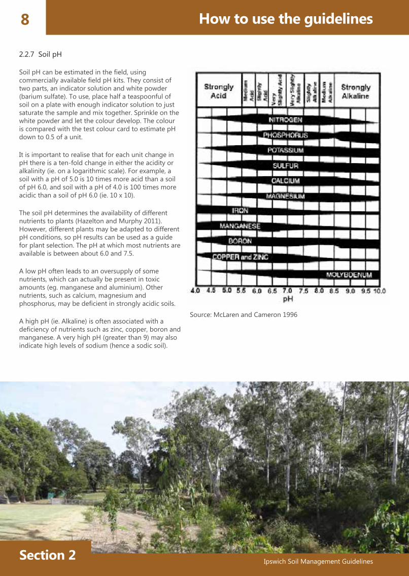
Soil pH can be estimated in the field, using commercially available field pH kits. They consist of two parts, an indicator solution and white powder (barium sulfate). To use, place half a teaspoonful of soil on a plate with enough indicator solution to just saturate the sample and mix together. Sprinkle on the white powder and let the colour develop. The colour is compared with the test colour card to estimate pH down to 0.5 of a unit.
It is important to realise that for each unit change in pH there is a ten-fold change in either the acidity or alkalinity (ie. on a logarithmic scale). For example, a soil with a pH of 5.0 is 10 times more acid than a soil of pH 6.0, and soil with a pH of 4.0 is 100 times more acidic than a soil of pH 6.0 (ie. 10 x 10).
The soil pH determines the availability of different nutrients to plants (Hazelton and Murphy 2011). However, different plants may be adapted to different pH conditions, so pH results can be used as a guide for plant selection. The pH at which most nutrients are available is between about 6.0 and 7.5.
A low pH often leads to an oversupply of some nutrients, which can actually be present in toxic amounts (eg. manganese and aluminium). Other nutrients, such as calcium, magnesium and phosphorus, may be deficient in strongly acidic soils.
A high pH (ie. Alkaline) is often associated with a deficiency of nutrients such as zinc, copper, boron and manganese. A very high pH (greater than 9) may also indicate high levels of sodium (hence a sodic soil).
How to use the guidelines
2.2.7 Soil pH
Source: McLaren and Cameron 1996
Section 2Ipswich Soil Management Guidelines
9Soil Type Key
The following key identifies the main distinguishing features of each soil group (after Isbell 2002).
Soil profiles with a relatively uniform clay texture throughout all layersof soil and that develop vertical cracks down from the surface as they dry ......................................Vertosols (p.10)
Other soil profiles that are saturated either permanently or for a period ofmonths in most years .............................................................................................................................................Hydrosols (p.14)
Other soil profiles in which texture increases substantially over a very narrowboundary between the subsoil and overlying layers (referred to as texture contrast) with:
Subsoils that have a pH of < 5.5 ......................................................................Kurosols (p.17)
Subsoil which is sodic (often dispersive in water) .....................................Sodosols (p.21)
Subsoils that have a pH of > 5.5 and not sodic .................................. Chromosols (p.25)
Other soil profiles with a relatively uniform clay to clay loam texture throughoutall layers of soil. Soil has more than weak structure in the subsoil .....................................................Dermosols (p.29)
Other soil profiles in which texture gradually increases with depth
(more clayey with depth) and often range from sand on the surface to sandy
light clay in the subsoil. Soils with little to no structure throughout ..................................................Kandosols (p.33)
Other soil profiles with alluvial deposition layers throughout.
Located adjacent to water courses ......................................................................................................Stratic Rudosols (p.36)
Other soils which are shallow (< 0.5m), and rocky or with very little
soil material overlying rock ........................................................................................Leptic Rudosols and Tenosols (p.39)

Ipswich Soil Management GuidelinesSection 3
10 Soil Type Confirmation and ReviewVe
rtoso
lsH
ydro
sols
Kuro
sols
Sodo
sols
Chro
mos
ols
Der
mos
ols
Stra
tic R
udos
ols
Lept
ic R
udos
ols
These soils have cracks > 5 mm wide that extend to the surface when the soil is dry. These soils generally have dark brown to black topsoils overlying subsoils which can range in colour from red, brown black and grey. Gilgai (melon-holes) formation may also be observed on these soils.
The texture of these soils is predominantly clay throughout. Subsoils may also be mottled and contain calcium carbonate (lime) and/or manganese nodules (black charcoal-like material).
The soils are wide spread and occur on alluvium, basic volcanics, Walloon Coal Measures and limestone sediments. These soils can be shallow, but are generally moderate to deep.
The pH of these soils is neutral to strongly alkaline.
These soils will crack when dry and the surface condition may include self-mulching, cracking, firm and sometimes crusting.
Vertosols can be grouped based on their dominant colour to 0.5m - Grey, Brown, Black and Red.
4.1 Vertosols (Cracking clay soils)
4.1.1 Description
Vert
osol
sKa
ndos
ols
Black VertosolSource: Queensland Government (DSITIA)
Grey VertosolSource: Queensland Government (DSITIA)
Brown VertosolSource: Queensland Government (DSITIA)
Black Vertosol on dolomite limestoneSource: Queensland Government (DSITIA)

Ipswich Soil Management Guidelines Section 3
11
Ipswich Soil Management Guidelines
VertosolsH
ydrosolsKurosols
SodosolsChrom
osolsVertosols
Derm
osolsStratic Rudosols
Leptic Rudosols
Soil Property Behaviour of soil to activity or environment
Management responses/measures
Soil surface
These soils generally have a well-structured surface with a surface condition which is self-mulching, cracking, firm or sometimes crusting.
A fine well-structured clay surface generally provides good soil-seed contact, but soil-seed contact may be poor in coarse structured soils (more likely to occur on black or grey clays).
For coarse structured soils, adequate seed bed preparation and rolling (i.e. press wheels or light rollers on seeding equipment) will improve germination.The addition of gypsum and/or composted organic matter is likely to assist with improving surface structure in coarse structured soils.
Infiltration in these soils may initially be rapid particularly if large cracks exist, but once wet infiltration will be slow and surface sealing will result in almost all water running off.
Surface infiltration rate can be increased through the incorporation of organic matter and by maintaining vegetative cover.Be mindful about irrigation rate. Low intensity irrigation will assist deep water penetration and limit surface sealing.
Expansive clays
These soils contain expansive clays and some soils will have very high shrink swell properties.
All these soils contain shrink-swell clays.
Appropriate design is required to avoid damage to infrastructure.Maintaining constant moisture content will limit shrink swell damage (ie. If expansive soils are dry, stop them from expanding by keeping them dry).Compaction relief for revegetation may be required when near surface and required for initial establishment. Soil will naturally crack compaction layers on successive drying and wetting cycles.
Clay subsoils
These soils may be grouped into, red, brown, grey or black sub groups.
Soils with grey colours generally have imperfect to poor drainage, black colours are slightly better drained while brown and red colours indicate moderate to well drained conditions.
Subsoil drainage will be slow and these soils are generally unsuitable for septic systems, however home sewage treatment systems with adequate area for surface irrigation are suitable.
Depending on landscape position these soils can stay wet for long periods of time.
Appropriate drainage design and materials (ie. sand and gravel) can improve site access for construction.Water diversion or vegetation may limit waterlogging at some locations.
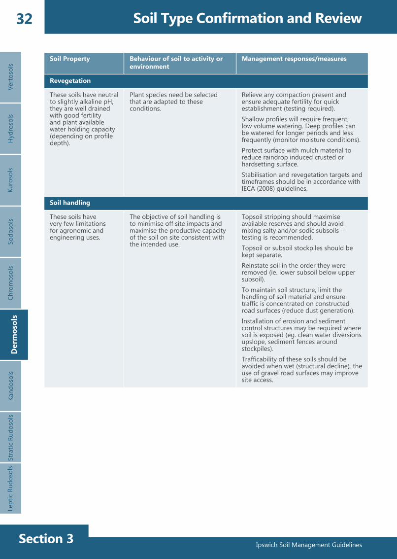
4.1.2 Vertosol characteristics
Soil Type Confirmation and ReviewKandosols

Ipswich Soil Management GuidelinesSection 3
12 Soil Type Confirmation and Review
Soil Property Behaviour of soil to activity or environment
Management responses/measures
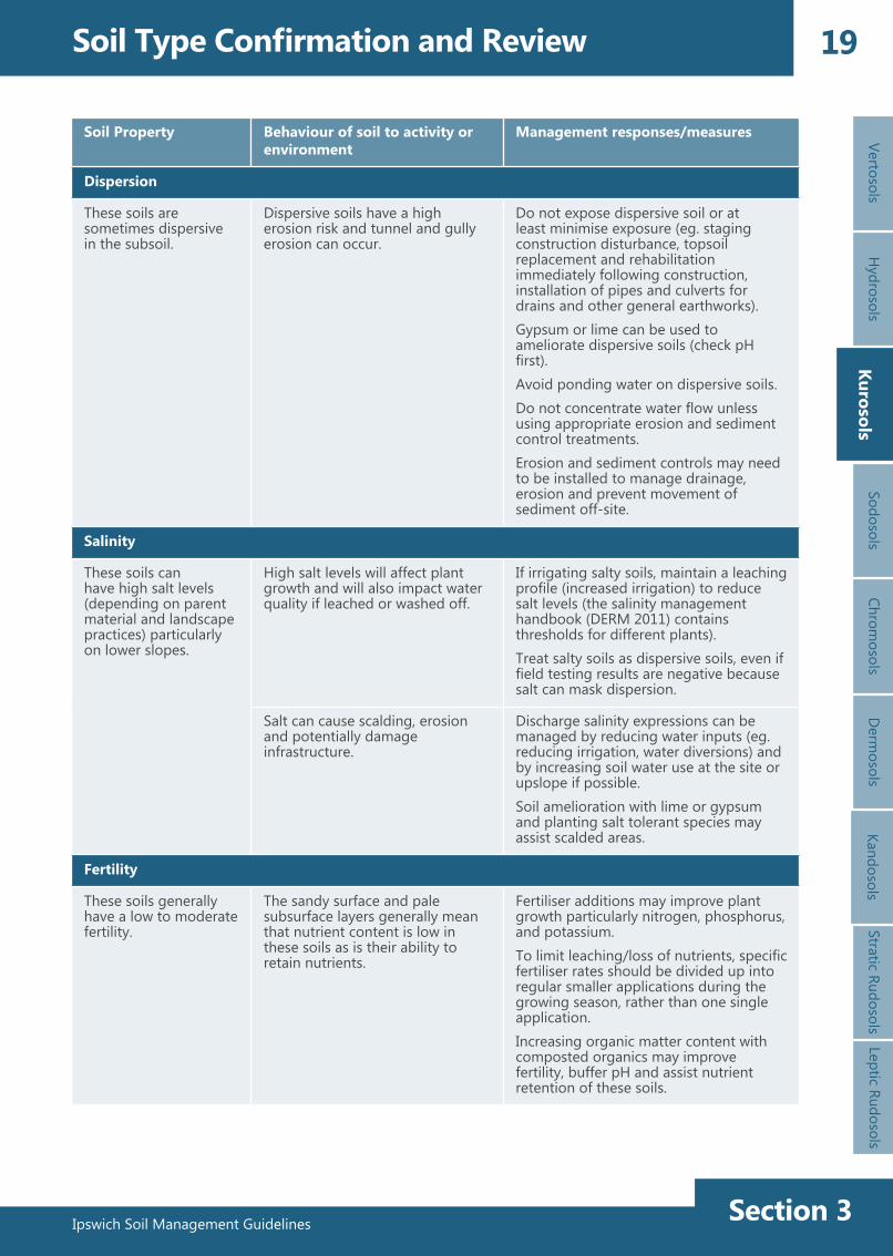
Dispersion
These soils often have dispersive subsoils. Soils formed on dolomite or limestone are usually non-dispersive.
Dispersive soils have a high erosion risk.
Do not expose dispersive subsoil or at least minimise exposure e.g. Staging construction disturbance, topsoil replacement and rehabilitation immediately following construction, installation of pipes and culverts for drains and other general earthworks.Gypsum can be used to ameliorate dispersive soils and assist drainage and improve soil structure.Avoid ponding of water.Do not concentrate water flow unless using appropriate treatment measures.Erosion and sediment controls may need to be installed to manage drainage, erosion and prevent movement of sediment off-site.
Salinity
These soils can have high salt levels (depending on parent material and landscape practices) particularly on lower slopes.
High salt levels will affect plant growth and will also impact water quality if leached or washed off.
If irrigating salty soils, maintain a leaching profile (ie. increased irrigation) to reduce salt levels (the salinity management handbook (DERM 2011) contains thresholds for different plants).Treat salty soils as dispersive soils, even if field testing results are negative because salt can mask dispersion.
Salt can cause scalding and erosion and damage infrastructure.
Salinity expressions (ie. discharges) can be managed by reducing water inputs (eg. reducing irrigation, water diversions) and by increasing soil water usage at the site or upslope if possible.Soil amelioration with gypsum and planting salt tolerant species may assist scald areas.
Fertility
These soils are often very fertile.
High clay content and generally high fertility.
Fertiliser additions will generally improve plant growth, particularly nitrogen and phosphorus (testing required). Fertiliser selection will depend on plant species.Topsoil retention should be maximised through appropriate soil handling practices.
Verto
sols
Hyd
roso
lsKu
roso
lsSo
doso
lsCh
rom
osol
sD
erm
osol
sSt
ratic
Rud
osol
sLe
ptic
Rud
osol
sVe
rtos
ols
Kand
osol
s
Ipswich Soil Management Guidelines Section 3
13
Ipswich Soil Management Guidelines
VertosolsH
ydrosolsKurosols
SodosolsChrom
osolsVertosols
Derm
osolsStratic Rudosols
Leptic Rudosols
Soil Property Behaviour of soil to activity or environment
Management responses/measures
Revegetation
These soils crack, are alkaline, moderately to poorly drained with good fertility and high plant available water holding capacity.
Plant species need be selected that are adapted to these unique soil conditions.
Plant selection targeted specifically to shrink-swell soils.Depending on landscape position these soils can stay wet for long periods of time, therefore plants need to be tolerant of these conditions.Low intensity, deep watering will assist full profile wetting and longer interval between irrigations.Fertiliser additions (where required) should be applied before and during plant growing periods. Stabilisation and revegetation targets and timeframes should be in accordance with IECA (2008) guidelines.
Soil handling
Some of these soils have very salty and/or dispersive subsoils.
The objective of soil handling is to minimise off site impacts and maximise the productive capacity of the soil on site consistent with the intended use.
Topsoil stripping should maximise available reserves and should avoid mixing salty and/or sodic subsoils with the topsoil – testing is recommended.Topsoil or subsoil stockpiles should be kept separate.Ensure subsoil is adequately covered with topsoil material. Plant establishment may not be possible in subsoil material alone.Reinstate soil in the order they were removed (ie. deeper subsoil reinstated below upper subsoil)Dispersive materials should be covered with adequate topsoil material to protect from erosion (amelioration with gypsum and/or soil stabilisers may be needed).Install erosion and sediment control structures where soil is exposed (ie. clean water diversions upslope, sediment fences around stockpiles, sediment control structures downslope).Wet clay soil material is difficult to handle.Traffic movement not recommended when wet.
Soil Type Confirmation and ReviewKandosols

Ipswich Soil Management GuidelinesSection 3
14 Soil Type Confirmation and ReviewVe
rtoso
lsH
ydro
sols
Kuro
sols
Sodo
sols
Chro
mos
ols
Der
mos
ols
Stra
tic R
udos
ols
Lept
ic R
udos
ols
4.2 Hydrosols (Waterlogged soils)
4.2.1 Description
Hyd
roso
lsKa
ndos
ols
Redoxic (mottled) HydrosolSource: Queensland Government (DSITIA)
These soils are wet for prolonged periods seasonally (between 2 - 3 months) or permanently waterlogged. These soils will generally occur in lower slope positions where the drainage of the site is poor.
Saturation may only occur in the deeper subsoil but may be wet to the soil surface. Wetness is often due to seepage from higher sites which may also result in the accumulation of salts.
Most Hydrosols will have strong abundant mottling and/or greyish blue colours (gley colours), which are evidence of reduced or waterlogged conditions.
These soils may have similar physical properties to many of the other soil types mentioned in this guideline (eg. uniform clay, texture contrast soil), but due to their periodic or permanent waterlogged status, they are grouped into this unit.
Due to the wet conditions and reduced biotic activity, Hydrosols often have high to very high levels of organic matter content in the topsoil.Development on these soils often requires drainage prior to or during any works.
Consideration should be given to the influence of adjacent wetland dependent ecosystems when any drainage works are being conducted and also limit the period of disturbance.

Ipswich Soil Management Guidelines Section 3
15
Ipswich Soil Management Guidelines
VertosolsH
ydrosolsKurosols
SodosolsChrom
osolsH
ydrosolsD
ermosols
Stratic RudosolsLeptic Rudosols
Soil Property Behaviour of soil to activity or environment
Management responses/measures
Soil surface
These soils often have surface water present which leads to a very soft soil surface.
The wet conditions limit access to these areas and in many cases vehicles access is not possible.
Trafficability of these soils may be difficult: the use of gravel surfaces will improve site access.
Expansive clays
These soils may contain expansive clays, but if consistently wet will not shrink-swell.
Maintaining constant moisture conditions will limit shrink-swell of any expansive clay material present.
Drainage of these soils may lead to soil shrinking and swelling on re-wetting.
Clay subsoils
These soils often contain clay subsoils that are mottled.
These soils have poor drainage and are either permanently wet or stay wet for extended periods of time.
Handling of wet clay subsoil may be difficult.Subsoil material generally unsuitable for use on the soil surface and should be adequately covered with topsoil. Appropriate drainage design and materials (ie. sand and gravel) can improve site access for construction (consider adjacent wetland ecosystems and shrink-swell soils).Plant roots are generally able to extend into the subsoil material without physical limitation.
Dispersion
These soils are generally non-dispersive, however testing will be needed to confirm.
Although not generally dispersive, these soils may be susceptible to stream bank erosion.
Stream bank erosion managed by maintaining vegetative cover and encouraging plants with fibrous root systems.
Salinity
These soils can have high salt levels (depending on parent material and landscape practices).
High salt levels will affect plant growth and will also impact water quality if leached or washed off.
If irrigating salty soils, maintain a leaching profile (ie. increase irrigation) to reduce salt levels (the salinity management handbook (DERM 2011) contains thresholds for different plants). Treat salty soils as dispersive soils, even if field testing results are negative because salt can mask dispersion.
Salt can cause scalding, erosion and damage to infrastructure.
Discharge salinity expressions can be managed by reducing water inputs (eg. reducing irrigation, water diversions) and by increasing soil water use at the site or upslope if possible (eg. planting deep rooted trees, install drainage structures).When revegetating, salt tolerant species will be required on scald areas.
4.2.2 Hydrosol characteristics
Soil Type Confirmation and ReviewKandosols

Ipswich Soil Management GuidelinesSection 3
16 Soil Type Confirmation and Review
Soil Property Behaviour of soil to activity or environment
Management responses/measures
Fertility
These soils generally have moderate fertility but waterlogging may restrict growth.
The high organic content provides a large nutrient reserve, but the wet, low oxygen conditions are suited to only certain plants.
Improving drainage and aeration of the waterlogged soil may enhance biotic activity and the subsequent release of nutrients stored in the organic matter. Wetland communities need to be considered before drainage is undertaken.Due to their location in a depositional environment, the wetland soils may contain contaminants that have been transported by water (testing may be required).
Revegetation
These soils are poorly drained with moderate fertility and neutral to alkaline pH.
Plant species need be selected that are adapted to these waterlogged conditions.
Select local wetland plants for rehabilitation purposes.Consideration needs to be given regarding the possible changes to the soil and environment if improved drainage measures are to be installed.Fertiliser use is generally not recommended due to the wetland location and possibility of increased algal growth.Stabilisation and revegetation targets and timeframes should be in accordance with IECA (2008) guidelines.
Soil handling
The wet conditions often make soil handling difficult.
The objective of soil handling is to minimise off site impacts and maximise the productive capacity of the soil on site consistent with the intended use.
Topsoil stripping should maximise available reserves and should avoid mixing with subsoil material – a simple survey of the site is recommended.Topsoil and subsoil stockpiles should be kept separate.Final placement of subsoil materials should be covered with adequate topsoil material to promote revegetation.Reinstate soil in the order they were removed (ie. deeper subsoil reinstated below upper subsoil)Installation of erosion and sediment control structures may be required where soil is exposed (eg. clean water diversions upslope, sediment fences around stockpiles, sediment control structures downslope).Trafficability of these soils may be difficult; avoid traffic on these soils where possible, otherwise the use of gravel road surfaces may improve site access.Minimise the handling of topsoil material and ensure traffic is concentrated on constructed road surfaces to reduce soil degradation.
Verto
sols
Hyd
roso
lsKu
roso
lsSo
doso
lsCh
rom
osol
sD
erm
osol
sSt
ratic
Rud
osol
sLe
ptic
Rud
osol
sH
ydro
sols
Kand
osol
s
Ipswich Soil Management Guidelines Section 3
17
Ipswich Soil Management Guidelines
VertosolsH
ydrosolsKurosols
SodosolsChrom
osolsKurosols
Derm
osolsStratic Rudosols
Leptic Rudosols
Soil Type Confirmation and ReviewKandosols
4.3 Kurosols (Acidic texture contrast soils)
4.3.1 Description
Sandy pale subsurface from 0.1m to 0.3mSource: Queensland Government (DSITIA)
Brown Kurosol with ironstone nodulesSource: Queensland Government (DSITIA)
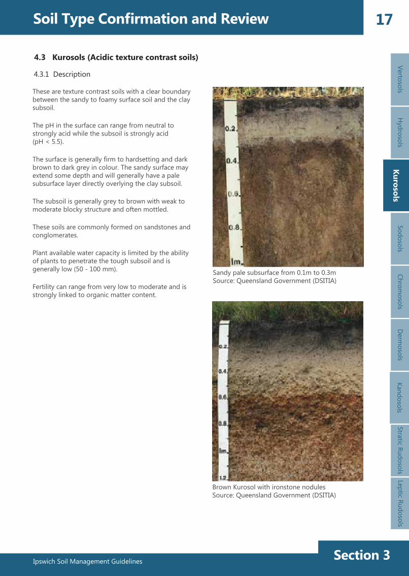
These are texture contrast soils with a clear boundary between the sandy to foamy surface soil and the clay subsoil.
The pH in the surface can range from neutral to strongly acid while the subsoil is strongly acid (pH < 5.5).
The surface is generally firm to hardsetting and dark brown to dark grey in colour. The sandy surface may extend some depth and will generally have a pale subsurface layer directly overlying the clay subsoil.
The subsoil is generally grey to brown with weak to moderate blocky structure and often mottled.
These soils are commonly formed on sandstones and conglomerates.
Plant available water capacity is limited by the ability of plants to penetrate the tough subsoil and is generally low (50 - 100 mm).
Fertility can range from very low to moderate and is strongly linked to organic matter content.

Ipswich Soil Management GuidelinesSection 3
18 Soil Type Confirmation and ReviewVe
rtoso
lsH
ydro
sols
Kuro
sols
Sodo
sols
Chro
mos
ols
Der
mos
ols
Stra
tic R
udos
ols
Lept
ic R
udos
ols
Kuro
sols
Kand
osol
s
Soil Property Behaviour of soil to activity or environment
Management responses/measures
Soil surface
These soils generally have weak structure in the surface with a firm to hardsetting surface condition.
A firm to hardsetting surface will generally have poor initial infiltration resulting in a large proportion of water running off causing erosion.
Surface infiltration rate can be increased through the incorporation of composted organic matter and by maintaining vegetative cover.
A hardsetting surface will also cause poor germination and seedling emergence.
Soil structure and moisture holding capacity can be improved through the incorporation of composted organic matter leading to better seedling establishment.
A sandy to loamy surface with poor structure can have low soil strength causing trafficability issues.
Trafficability of these soils may be difficult when wet, however the use of gravel road surfaces may improve site access.
If sandy to loamy surface soil with poor structure and low soil strength is overworked or excessively trafficked there is a high potential to generate dust.
Limit traffic and do not disturb unless necessary to avoid destruction of the soil structure.Construct gravel roads on the site and limit access off these roads.Consider the use of soil stabilisation products (ie. polymer sprays).
Expansive clays
These soils contain little to no expansive clays.
Clay subsoils
These soils contain acidic clay subsoils that may range from red to grey and may be mottled.
Soils with grey and yellow subsoils generally have imperfect to poor drainage, while brown and red subsoils will be better drained.
Subsoil drainage will generally be slow and these soils are generally unsuitable for septic systems, however home sewage treatment systems with adequate area for surface irrigation are suitable.Acidic subsoil material is unsuitable for use on the soil surface and should be adequately covered with topsoil. Addition of lime may be required to adjust soil pH to improve rehabilitation.Poorly structured, dense subsoil material significantly restricts plant root extension into the subsoil. Addition of lime or gypsum may assist in improving soil structure.
Depending on landscape position these soils can stay wet for long periods of time.
Appropriate drainage design and materials (ie. sand and gravel) can improve site access for construction.Water diversions or vegetation corridors may limit waterlogging at some locations.
4.3.2 Kurosol characteristics
Ipswich Soil Management Guidelines Section 3
19
Ipswich Soil Management Guidelines
VertosolsH
ydrosolsKurosols
SodosolsChrom
osolsKurosols
Derm
osolsStratic Rudosols
Leptic Rudosols
Soil Type Confirmation and ReviewKandosols
Soil Property Behaviour of soil to activity or environment
Management responses/measures
Dispersion
These soils are sometimes dispersive in the subsoil.
Dispersive soils have a high erosion risk and tunnel and gully erosion can occur.
Do not expose dispersive soil or at least minimise exposure (eg. staging construction disturbance, topsoil replacement and rehabilitation immediately following construction, installation of pipes and culverts for drains and other general earthworks).Gypsum or lime can be used to ameliorate dispersive soils (check pH first).Avoid ponding water on dispersive soils.Do not concentrate water flow unless using appropriate erosion and sediment control treatments.Erosion and sediment controls may need to be installed to manage drainage, erosion and prevent movement of sediment off-site.
Salinity
These soils can have high salt levels (depending on parent material and landscape practices) particularly on lower slopes.
High salt levels will affect plant growth and will also impact water quality if leached or washed off.
If irrigating salty soils, maintain a leaching profile (increased irrigation) to reduce salt levels (the salinity management handbook (DERM 2011) contains thresholds for different plants).Treat salty soils as dispersive soils, even if field testing results are negative because salt can mask dispersion.
Salt can cause scalding, erosion and potentially damage infrastructure.
Discharge salinity expressions can be managed by reducing water inputs (eg. reducing irrigation, water diversions) and by increasing soil water use at the site or upslope if possible.Soil amelioration with lime or gypsum and planting salt tolerant species may assist scalded areas.
Fertility
These soils generally have a low to moderate fertility.
The sandy surface and pale subsurface layers generally mean that nutrient content is low in these soils as is their ability to retain nutrients.
Fertiliser additions may improve plant growth particularly nitrogen, phosphorus, and potassium.To limit leaching/loss of nutrients, specific fertiliser rates should be divided up into regular smaller applications during the growing season, rather than one single application.Increasing organic matter content with composted organics may improve fertility, buffer pH and assist nutrient retention of these soils.
Ipswich Soil Management GuidelinesSection 3
20 Soil Type Confirmation and ReviewVe
rtoso
lsH
ydro
sols
Kuro
sols
Sodo
sols
Chro
mos
ols
Der
mos
ols
Stra
tic R
udos
ols
Lept
ic R
udos
ols
Kuro
sols
Kand
osol
s
Soil Property Behaviour of soil to activity or environment
Management responses/measures
Revegetation
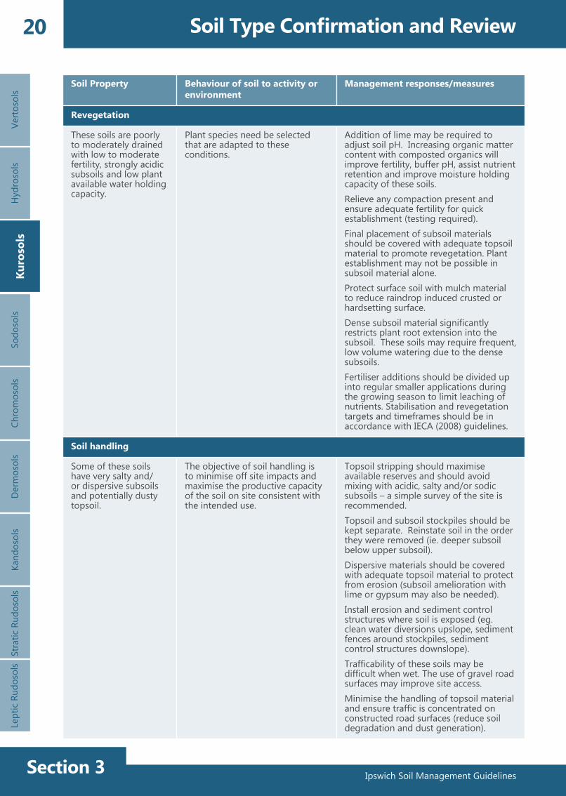
These soils are poorly to moderately drained with low to moderate fertility, strongly acidic subsoils and low plant available water holding capacity.
Plant species need be selected that are adapted to these conditions.
Addition of lime may be required to adjust soil pH. Increasing organic matter content with composted organics will improve fertility, buffer pH, assist nutrient retention and improve moisture holding capacity of these soils.Relieve any compaction present and ensure adequate fertility for quick establishment (testing required).Final placement of subsoil materials should be covered with adequate topsoil material to promote revegetation. Plant establishment may not be possible in subsoil material alone.Protect surface soil with mulch material to reduce raindrop induced crusted or hardsetting surface.Dense subsoil material significantly restricts plant root extension into the subsoil. These soils may require frequent, low volume watering due to the dense subsoils.Fertiliser additions should be divided up into regular smaller applications during the growing season to limit leaching of nutrients. Stabilisation and revegetation targets and timeframes should be in accordance with IECA (2008) guidelines.
Soil handling
Some of these soils have very salty and/or dispersive subsoils and potentially dusty topsoil.
The objective of soil handling is to minimise off site impacts and maximise the productive capacity of the soil on site consistent with the intended use.
Topsoil stripping should maximise available reserves and should avoid mixing with acidic, salty and/or sodic subsoils – a simple survey of the site is recommended.Topsoil and subsoil stockpiles should be kept separate. Reinstate soil in the order they were removed (ie. deeper subsoil below upper subsoil).Dispersive materials should be covered with adequate topsoil material to protect from erosion (subsoil amelioration with lime or gypsum may also be needed).Install erosion and sediment control structures where soil is exposed (eg. clean water diversions upslope, sediment fences around stockpiles, sediment control structures downslope).Trafficability of these soils may be difficult when wet. The use of gravel road surfaces may improve site access.Minimise the handling of topsoil material and ensure traffic is concentrated on constructed road surfaces (reduce soil degradation and dust generation).

Ipswich Soil Management Guidelines Section 3
21
Ipswich Soil Management Guidelines
VertosolsH
ydrosolsKurosols
SodosolsChrom
osolsSodosols
Derm
osolsStratic Rudosols
Leptic Rudosols
Soil Type Confirmation and ReviewKandosols
4.4 Sodosols (Sodic, alkaline, texture contrast soils)
4.4.1 Description
Shallow Brown Sodosol over sandstoneSource: Queensland Government (DSITIA)
Brown Sodosol with coarse structured subsoilSource: Queensland Government (DSITIA)
Texture contrast soils with a clear boundary between the sandy to loamy surface soil and the clay subsoil.
The surface is generally hardsetting and brown to dark grey in colour.
There is likely to be a pale subsurface layer directly overlying the clay subsoil. The clay subsoil has a coarse structure and ranges in colour from red brown through yellow to grey.
Subsoils may be mottled and may contain manganese (black) nodules.
The pH in the surface can range from neutral to strongly acid while the subsoil is usually strongly alkaline.
Subsoils are often dispersive and/or salty.
Plant available water content will be low due to sodic and/or salty subsoils restricting rooting depth.
Fertility can range from very low to moderate and is strongly dependent on organic matter content.

Ipswich Soil Management GuidelinesSection 3
22 Soil Type Confirmation and ReviewVe
rtoso
lsH
ydro
sols
Kuro
sols
Sodo
sols
Chro
mos
ols
Der
mos
ols
Stra
tic R
udos
ols
Lept
ic R
udos
ols
Sodo
sols
Kand
osol
s
Soil Property Behaviour of soil to activity or environment
Management responses/measures
Soil surface
These soils generally have weak structure in the surface with a firm to hardsetting surface condition.
A firm to hardsetting surface will generally have poor initial infiltration resulting in a large proportion of water running off causing erosion.
Surface infiltration rate can be increased through the incorporation of composted organic matter and by maintaining vegetative cover.
A hardsetting surface will also cause poor germination and seedling emergence.
Soil structure and moisture holding capacity can be improved through the incorporation of composted organic matter leading to better seedling establishment.
A sandy to loamy surface with poor structure can have low soil strength causing trafficability issues.
Trafficability of these soils may be difficult when wet, however the use of gravel road surfaces may improve site access.
If sandy to loamy surface soil with poor structure and low soil strength is overworked or excessively trafficked there is a high potential to generate dust.
Limit traffic and do not disturb unless necessary to avoid destruction of the soil structure.Construct gravel roads on the site and limit access off these roads.Consider the use of soil stabilisation products (ie. polymer sprays).
Expansive clays
These soils contain little to no expansive clays.
Clay subsoils
These soils contain dense sodic, alkaline clay subsoils that are commonly mottled.
These soils have imperfect to poor drainage.
Subsoil drainage will be slow.Alkaline subsoil material is unsuitable for use on the soil surface and should be adequately covered with topsoil.Poorly structured, dense subsoil material significantly restricts plant root extension into the subsoil. Addition of gypsum may assist in improving soil structure.
Depending on landscape position these soils can stay wet for long periods of time.
Appropriate drainage design and materials (eg. sand and gravel) can improve site access for construction.Water diversion or vegetation may limit waterlogging at some locations.
4.4.2 Sodosol characteristics
Ipswich Soil Management Guidelines Section 3
23
Ipswich Soil Management Guidelines
VertosolsH
ydrosolsKurosols
SodosolsChrom
osolsD
ermosols
Stratic RudosolsLeptic Rudosols
Soil Type Confirmation and ReviewKandosols
Soil Property Behaviour of soil to activity or environment
Management responses/measures
Dispersion
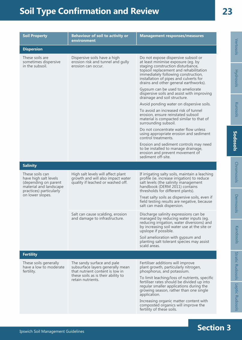
These soils are sometimes dispersive in the subsoil.
Dispersive soils have a high erosion risk and tunnel and gully erosion can occur.
Do not expose dispersive subsoil or at least minimise exposure (eg. by staging construction disturbance, topsoil replacement and rehabilitation immediately following construction, installation of pipes and culverts for drains and other general earthworks).Gypsum can be used to ameliorate dispersive soils and assist with improving drainage and soil structure.Avoid ponding water on dispersive soils.To avoid an increased risk of tunnel erosion, ensure reinstated subsoil material is compacted similar to that of surrounding subsoil. Do not concentrate water flow unless using appropriate erosion and sediment control treatments.Erosion and sediment controls may need to be installed to manage drainage, erosion and prevent movement of sediment off-site.
Salinity
These soils can have high salt levels (depending on parent material and landscape practices) particularly on lower slopes.
High salt levels will affect plant growth and will also impact water quality if leached or washed off.
If irrigating salty soils, maintain a leaching profile (ie. increase irrigation) to reduce salt levels (the salinity management handbook (DERM 2011) contains thresholds for different plants).Treat salty soils as dispersive soils, even if field testing results are negative, because salt can mask dispersion.
Salt can cause scalding, erosion and damage to infrastructure.
Discharge salinity expressions can be managed by reducing water inputs (eg. reducing irrigation, water diversions) and by increasing soil water use at the site or upslope if possible.Soil amelioration with gypsum and planting salt tolerant species may assist scald areas.
Fertility
These soils generally have a low to moderate fertility.
The sandy surface and pale subsurface layers generally mean that nutrient content is low in these soils as is their ability to retain nutrients.
Fertiliser additions will improve plant growth, particularly nitrogen, phosphorus, and potassium.To limit leaching/loss of nutrients, specific fertiliser rates should be divided up into regular smaller applications during the growing season, rather than one single application.Increasing organic matter content with composted organics will improve the fertility of these soils.
Sodosols
Ipswich Soil Management GuidelinesSection 3
24 Soil Type Confirmation and ReviewVe
rtoso
lsH
ydro
sols
Kuro
sols
Sodo
sols
Chro
mos
ols
Der
mos
ols
Stra
tic R
udos
ols
Lept
ic R
udos
ols
Kand
osol
s
Soil Property Behaviour of soil to activity or environment
Management responses/measures
Revegetation
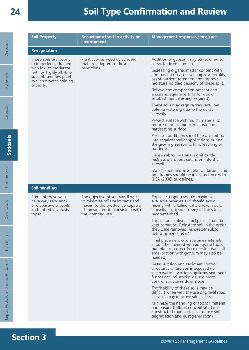
These soils are poorly to imperfectly drained with low to moderate fertility, highly alkaline subsoils and low plant available water holding capacity.
Plant species need be selected that are adapted to these conditions.
Addition of gypsum may be required to alleviate dispersion risk.Increasing organic matter content with composted organics will improve fertility, assist nutrient retention and improve moisture holding capacity of these soils.Relieve any compaction present and ensure adequate fertility for quick establishment (testing required).These soils may require frequent, low volume watering due to the dense subsoils.Protect surface with mulch material to reduce raindrop induced crusted or hardsetting surface.Fertiliser additions should be divided up into regular smaller applications during the growing season to limit leaching of nutrients.Dense subsoil material significantly restricts plant root extension into the subsoil.Stabilisation and revegetation targets and timeframes should be in accordance with IECA (2008) guidelines.
Soil handling
Some of these soils have very salty and/or dispersive subsoils and potentially dusty topsoil.
The objective of soil handling is to minimise off site impacts and maximise the productive capacity of the soil on site consistent with the intended use.
Topsoil stripping should maximise available reserves and should avoid mixing with alkaline, salty and/or sodic subsoils – a simple survey of the site is recommended.Topsoil and subsoil stockpiles should be kept separate. Reinstate soil in the order they were removed (ie. deeper subsoil below upper subsoil).Final placement of dispersive materials should be covered with adequate topsoil material to protect from erosion (subsoil amelioration with gypsum may also be needed).Install erosion and sediment control structures where soil is exposed (ie. clean water diversions upslope, sediment fences around stockpiles, sediment control structures downslope).Trafficability of these soils may be difficult when wet, the use of gravel road surfaces may improve site access.Minimise the handling of topsoil material and ensure traffic is concentrated on constructed road surfaces (reduce soil degradation and dust generation).
Sodo
sols

Ipswich Soil Management Guidelines Section 3
25
Ipswich Soil Management Guidelines
VertosolsH
ydrosolsKurosols
SodosolsChrom
osolsChrom
osolsD
ermosols
Stratic RudosolsLeptic Rudosols
Soil Type Confirmation and ReviewKandosols
4.5 Chromosols (Non-sodic texture contrast soils)
4.5.1 Description
Red Chromosol with well structured subsoilSource: Queensland Government (DSITIA)
Brown ChromosolSource: Queensland Government (DSITIA)
These soils may be located both on flat alluvial areas and on sloping land. These soils have texture contrast profiles with a clear boundary between the surface loamy soil and the clay subsoil.
The surface condition ranges from loose to hardsetting and is dark brown to dark grey in colour. There may be a pale layer directly overlying the clay subsoil.
Subsoils are generally slightly acidic to slightly alkaline (commonly neutral pH). Subsoil colours range from red, brown, black to grey. Mottling often occurs in the imperfectly drained subsoil, particularly in heavier clays.
The subsoil is non-sodic and as a result is generally not dispersive.
Salt levels in the subsoil can be very high, depending on parent material and landscape position.
Fertility is generally low to moderate and is strongly linked to organic matter content.
Ipswich Soil Management GuidelinesSection 3
26 Soil Type Confirmation and ReviewVe
rtoso
lsH
ydro
sols
Kuro
sols
Sodo
sols
Chro
mos
ols
Der
mos
ols
Stra
tic R
udos
ols
Lept
ic R
udos
ols
Chro
mos
ols
Kand
osol
s
Soil Property Behaviour of soil to activity or environment
Management responses/measures
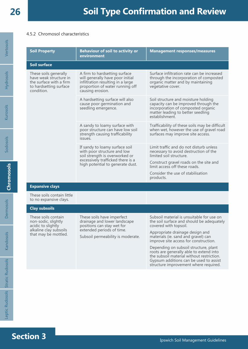
Soil surface
These soils generally have weak structure in the surface with a firm to hardsetting surface condition.
A firm to hardsetting surface will generally have poor initial infiltration resulting in a large proportion of water running off causing erosion.
Surface infiltration rate can be increased through the incorporation of composted organic matter and by maintaining vegetative cover.
A hardsetting surface will also cause poor germination and seedling emergence.
Soil structure and moisture holding capacity can be improved through the incorporation of composted organic matter leading to better seedling establishment.
A sandy to loamy surface with poor structure can have low soil strength causing trafficability issues.
Trafficability of these soils may be difficult when wet, however the use of gravel road surfaces may improve site access.
If sandy to loamy surface soil with poor structure and low soil strength is overworked or excessively trafficked there is a high potential to generate dust.
Limit traffic and do not disturb unless necessary to avoid destruction of the limited soil structure.Construct gravel roads on the site and limit access off these roads.Consider the use of stabilisation products.
Expansive clays
These soils contain little to no expansive clays.
Clay subsoils
These soils contain non-sodic, slightly acidic to slightly alkaline clay subsoils that may be mottled.
These soils have imperfect drainage and lower landscape positions can stay wet for extended periods of time. Subsoil permeability is moderate.
Subsoil material is unsuitable for use on the soil surface and should be adequately covered with topsoil. Appropriate drainage design and materials (ie. sand and gravel) can improve site access for construction.Depending on subsoil structure, plant roots are generally able to extend into the subsoil material without restriction. Gypsum additions can be used to assist structure improvement where required.
4.5.2 Chromosol characteristics
Ipswich Soil Management Guidelines Section 3
27
Ipswich Soil Management Guidelines
VertosolsH
ydrosolsKurosols
SodosolsChrom
osolsD
ermosols
Stratic RudosolsLeptic Rudosols
Soil Type Confirmation and ReviewKandosols
Soil Property Behaviour of soil to activity or environment
Management responses/measures
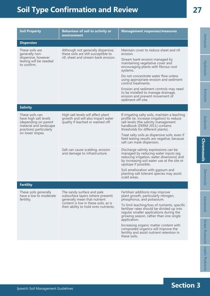
Dispersion
These soils are generally non-dispersive, however testing will be needed to confirm.
Although not generally dispersive, these soils are still susceptible to rill, sheet and stream bank erosion.
Maintain cover to reduce sheet and rill erosion.Stream bank erosion managed by maintaining vegetative cover and encouraging plants with fibrous root systems.Do not concentrate water flow unless using appropriate erosion and sediment control treatments.Erosion and sediment controls may need to be installed to manage drainage, erosion and prevent movement of sediment off-site.
Salinity
These soils can have high salt levels (depending on parent material and landscape practices) particularly on lower slopes.
High salt levels will affect plant growth and will also impact water quality if leached or washed off.
If irrigating salty soils, maintain a leaching profile (ie. increase irrigation) to reduce salt levels (the salinity management handbook (DERM 2011) contains thresholds for different plants).Treat salty soils as dispersive soils, even if field testing results are negative, because salt can mask dispersion.
Salt can cause scalding, erosion and damage to infrastructure.
Discharge salinity expressions can be managed by reducing water inputs (eg. reducing irrigation, water diversions) and by increasing soil water use at the site or upslope if possible.Soil amelioration with gypsum and planting salt tolerant species may assist scald areas.
Fertility
These soils generally have a low to moderate fertility.
The sandy surface and pale subsurface layers (where present) generally mean that nutrient content is low in these soils, as is their ability to hold onto nutrients.
Fertiliser additions may improve plant growth, particularly nitrogen, phosphorus, and potassium.To limit leaching/loss of nutrients, specific fertiliser rates should be divided up into regular smaller applications during the growing season, rather than one single application.Increasing organic matter content with composted organics will improve the fertility and assist nutrient retention in these soils.
Chromosols
Ipswich Soil Management GuidelinesSection 3
28 Soil Type Confirmation and ReviewVe
rtoso
lsH
ydro
sols
Kuro
sols
Sodo
sols
Chro
mos
ols
Der
mos
ols
Stra
tic R
udos
ols
Lept
ic R
udos
ols
Kand
osol
s
Soil Property Behaviour of soil to activity or environment
Management responses/measures
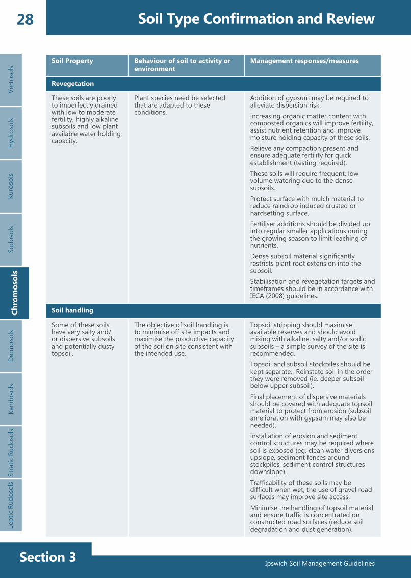
Revegetation
These soils are poorly to imperfectly drained with low to moderate fertility, highly alkaline subsoils and low plant available water holding capacity.
Plant species need be selected that are adapted to these conditions.
Addition of gypsum may be required to alleviate dispersion risk.Increasing organic matter content with composted organics will improve fertility, assist nutrient retention and improve moisture holding capacity of these soils.Relieve any compaction present and ensure adequate fertility for quick establishment (testing required).These soils will require frequent, low volume watering due to the dense subsoils.Protect surface with mulch material to reduce raindrop induced crusted or hardsetting surface.Fertiliser additions should be divided up into regular smaller applications during the growing season to limit leaching of nutrients.Dense subsoil material significantly restricts plant root extension into the subsoil.Stabilisation and revegetation targets and timeframes should be in accordance with IECA (2008) guidelines.
Soil handling
Some of these soils have very salty and/or dispersive subsoils and potentially dusty topsoil.
The objective of soil handling is to minimise off site impacts and maximise the productive capacity of the soil on site consistent with the intended use.
Topsoil stripping should maximise available reserves and should avoid mixing with alkaline, salty and/or sodic subsoils – a simple survey of the site is recommended.Topsoil and subsoil stockpiles should be kept separate. Reinstate soil in the order they were removed (ie. deeper subsoil below upper subsoil).Final placement of dispersive materials should be covered with adequate topsoil material to protect from erosion (subsoil amelioration with gypsum may also be needed).Installation of erosion and sediment control structures may be required where soil is exposed (eg. clean water diversions upslope, sediment fences around stockpiles, sediment control structures downslope).Trafficability of these soils may be difficult when wet, the use of gravel road surfaces may improve site access.Minimise the handling of topsoil material and ensure traffic is concentrated on constructed road surfaces (reduce soil degradation and dust generation).
Chro
mos
ols

Ipswich Soil Management Guidelines Section 3
29
Ipswich Soil Management Guidelines
VertosolsH
ydrosolsKurosols
SodosolsChrom
osolsD
ermosols
Stratic RudosolsLeptic Rudosols
Soil Type Confirmation and ReviewKandosols
4.6 Dermosols (Non-cracking clay to clay loam soils)
4.6.1 Description
Shallow Brown Dermosol over andesiteSource: Queensland Government (DSITIA)
Deep alluvial Brown DermosolSource: Queensland Government (DSITIA)
These clay to clay loam soils generally have a dark to brownish black surface over brown to grey-brown subsoils. Textures are generally clay to clay loam throughout with moderate to well-structured surface and subsoils.
These soils are widespread on mid to upper slope positions of low undulating hills of tertiary basalt, tertiary intrusions and tertiary sediments. These soils are also located on alluvial flats.
Soils on steeper slopes and in upper slope positions are generally shallow whereas soils on flatter land such as alluvium are generally deep. The surface of this soil is generally well-structured with a firm surface condition that may become hardsetting following cultivation.
These soils generally have a slightly acid to neutral surface pH, grading to neutral and moderately alkaline pH in the subsoil.
Dermosols commonly have free drainage characteristics with moderate fertility and moderate clay content making them ideal for agricultural production if sufficiently deep.

Ipswich Soil Management GuidelinesSection 3
30 Soil Type Confirmation and ReviewVe
rtoso
lsH
ydro
sols
Kuro
sols
Sodo
sols
Chro
mos
ols
Der
mos
ols
Stra
tic R
udos
ols
Lept
ic R
udos
ols
Der
mos
ols
Kand
osol
s
Soil Property Behaviour of soil to activity or environment
Management responses/measures
Soil surface
These soils generally have a well-structured surface with a firm surface condition and sometimes stony on slopes.
Surface structure can deteriorate following prolonged cultivation/handling to produce a hardsetting surface.
Excessive cultivation or handling of these soils should be avoided.
Soil structure and surface infiltration rate can be maintained through the incorporation of composted organic matter and by maintaining vegetative cover.
Limit traffic and do not disturb unless necessary to avoid destruction of the soil structure.Construct gravel roads on the site and limit access off these roads.
Expansive clays
These soils contain little to no shrink swell clays.
Some of these soils may contain layers of shrink swell clays at depth.
Reinstate soils in order they are removed (ie. topsoil above subsoil) to reduce possible effect on infrastructure.
Clay subsoils
These soils contain clay loam to medium clay subsoils that may be grouped into grey, brown or black sub groups.
Subsoils have moderate to strong structure with texture ranging from clay loam to medium clay. Where these soils are formed on weathered rock profiles may be shallow (some rocky), while those developed on alluvium are deep. The subsoil of this soil type is generally suitable for most earthwork purposes. However both the topsoil and subsoil are prone to structural decline and compaction.
Relieve compaction of subsoil material where revegetation required, amelioration with gypsum may assist (laboratory analysis will inform).Excessive handling of these soils should be avoided.
4.6.2 Dermosol characteristics
Ipswich Soil Management Guidelines Section 3
31
Ipswich Soil Management Guidelines
VertosolsH
ydrosolsKurosols
SodosolsChrom
osolsD
ermosols
Stratic RudosolsLeptic Rudosols
Soil Type Confirmation and ReviewKandosols
Soil Property Behaviour of soil to activity or environment
Management responses/measures
Dispersion
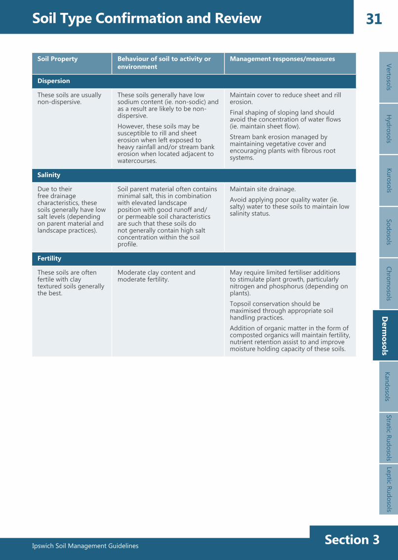
These soils are usually non-dispersive.
These soils generally have low sodium content (ie. non-sodic) and as a result are likely to be non-dispersive.However, these soils may be susceptible to rill and sheet erosion when left exposed to heavy rainfall and/or stream bank erosion when located adjacent to watercourses.
Maintain cover to reduce sheet and rill erosion.Final shaping of sloping land should avoid the concentration of water flows (ie. maintain sheet flow).Stream bank erosion managed by maintaining vegetative cover and encouraging plants with fibrous root systems.
Salinity
Due to their free drainage characteristics, these soils generally have low salt levels (depending on parent material and landscape practices).
Soil parent material often contains minimal salt, this in combination with elevated landscape position with good runoff and/or permeable soil characteristics are such that these soils do not generally contain high salt concentration within the soil profile.
Maintain site drainage.Avoid applying poor quality water (ie. salty) water to these soils to maintain low salinity status.
Fertility
These soils are often fertile with clay textured soils generally the best.
Moderate clay content and moderate fertility.
May require limited fertiliser additions to stimulate plant growth, particularly nitrogen and phosphorus (depending on plants).Topsoil conservation should be maximised through appropriate soil handling practices.Addition of organic matter in the form of composted organics will maintain fertility, nutrient retention assist to and improve moisture holding capacity of these soils.
Derm
osols
Ipswich Soil Management GuidelinesSection 3
32 Soil Type Confirmation and ReviewVe
rtoso
lsH
ydro
sols
Kuro
sols
Sodo
sols
Chro
mos
ols
Der
mos
ols
Stra
tic R
udos
ols
Lept
ic R
udos
ols
Kand
osol
s
Soil Property Behaviour of soil to activity or environment
Management responses/measures
Revegetation
These soils have neutral to slightly alkaline pH, they are well drained with good fertility and plant available water holding capacity (depending on profile depth).
Plant species need be selected that are adapted to these conditions.
Relieve any compaction present and ensure adequate fertility for quick establishment (testing required).Shallow profiles will require frequent, low volume watering. Deep profiles can be watered for longer periods and less frequently (monitor moisture conditions).Protect surface with mulch material to reduce raindrop induced crusted or hardsetting surface.Stabilisation and revegetation targets and timeframes should be in accordance with IECA (2008) guidelines.
Soil handling
These soils have very few limitations for agronomic and engineering uses.
The objective of soil handling is to minimise off site impacts and maximise the productive capacity of the soil on site consistent with the intended use.
Topsoil stripping should maximise available reserves and should avoid mixing salty and/or sodic subsoils – testing is recommended.Topsoil or subsoil stockpiles should be kept separate.Reinstate soil in the order they were removed (ie. lower subsoil below upper subsoil).To maintain soil structure, limit the handling of soil material and ensure traffic is concentrated on constructed road surfaces (reduce dust generation).Installation of erosion and sediment control structures may be required where soil is exposed (eg. clean water diversions upslope, sediment fences around stockpiles).Trafficability of these soils should be avoided when wet (structural decline), the use of gravel road surfaces may improve site access.
Der
mos
ols

Ipswich Soil Management Guidelines Section 3
33
Ipswich Soil Management Guidelines
VertosolsH
ydrosolsKurosols
SodosolsChrom
osolsStratic Rudosols
Leptic Rudosols
Soil Type Confirmation and ReviewKandasols
4.7 Kandosols (Sandy textured soils)
4.7.1 Description
Brown Kandosol with manganese nodules throughoutSource: Queensland Government (DSITIA)
Red KandosolSource: Queensland Government (DSITIA)
Shallow Brown KandosolSource: Queensland Government (DSITIA)
KandosolsD
ermosols
These soils are porous and friable with no structure (massive) to weakly developed structure.
Soil texture is commonly a sandy loam in the surface which may increase in clay content with depth to sandy light clay in the subsoil.
The surface is generally dark brown or grey brown in colour. The subsoil can range from red to brown to yellow depending on parent material and drainage. Yellow colours commonly occur in poorly drained positions
The pH of these soils ranges from neutral to strongly acid (pH 5.5) in the deep subsoil.
They are usually deep (typically greater than 1.0 m). These soils are usually formed from sedimentary rocks in low hill landscapes.
Plant available water capacity is low (50 – 100 mm). The fertility of these soils can vary significantly from very low to high, and is strongly dependent on organic matter content.
Ipswich Soil Management GuidelinesSection 3
34 Soil Type Confirmation and ReviewVe
rtoso
lsH
ydro
sols
Kuro
sols
Sodo
sols
Chro
mos
ols
Der
mos
ols
Stra
tic R
udos
ols
Lept
ic R
udos
ols
Kand
asol
s
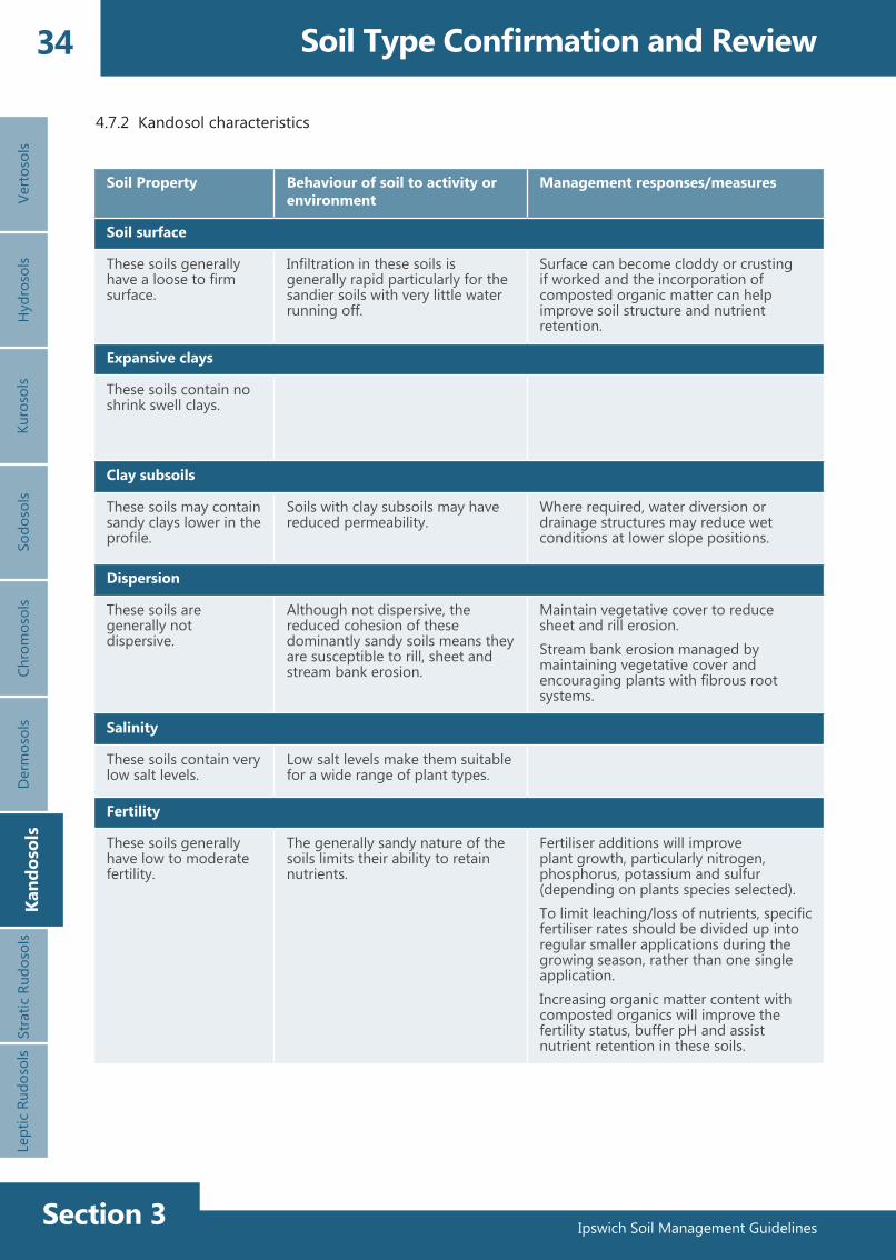
4.7.2 Kandosol characteristics
Kand
osol
s
Soil Property Behaviour of soil to activity or environment
Management responses/measures
Soil surface
These soils generally have a loose to firm surface.
Infiltration in these soils is generally rapid particularly for the sandier soils with very little water running off.
Surface can become cloddy or crusting if worked and the incorporation of composted organic matter can help improve soil structure and nutrient retention.
Expansive clays
These soils contain no shrink swell clays.
Clay subsoils
These soils may contain sandy clays lower in the profile.
Soils with clay subsoils may have reduced permeability.
Where required, water diversion or drainage structures may reduce wet conditions at lower slope positions.
Dispersion
These soils are generally not dispersive.
Although not dispersive, the reduced cohesion of these dominantly sandy soils means they are susceptible to rill, sheet and stream bank erosion.
Maintain vegetative cover to reduce sheet and rill erosion.Stream bank erosion managed by maintaining vegetative cover and encouraging plants with fibrous root systems.
Salinity
These soils contain very low salt levels.
Low salt levels make them suitable for a wide range of plant types.
Fertility
These soils generally have low to moderate fertility.
The generally sandy nature of the soils limits their ability to retain nutrients.
Fertiliser additions will improve plant growth, particularly nitrogen, phosphorus, potassium and sulfur (depending on plants species selected).To limit leaching/loss of nutrients, specific fertiliser rates should be divided up into regular smaller applications during the growing season, rather than one single application.Increasing organic matter content with composted organics will improve the fertility status, buffer pH and assist nutrient retention in these soils.

Ipswich Soil Management Guidelines Section 3
35
Ipswich Soil Management Guidelines
VertosolsH
ydrosolsKurosols
SodosolsChrom
osolsD
ermosols
Stratic RudosolsLeptic Rudosols
Soil Type Confirmation and ReviewKandasols
Kandosols
Soil Property Behaviour of soil to activity or environment
Management responses/measures
Revegetation
These soils have dominantly neutral pH, are well drained, moderately fertile and moderate plant available water holding capacity.
Plant species need be selected that are adapted to these conditions.
Due to the light surface textures, regular maintenance watering may be required during the establishment period.These soils could be watered deeply to encourage deep root growth (monitor moisture conditions).Protect surface with mulch material to reduce raindrop induced crusted or hardsetting surface.Fertiliser additions should be divided up into regular smaller applications during the growing season to limit leaching of nutrients.Increasing organic matter content with composted organics will improve the fertility status, assist nutrient retention and improve moisture holding capacity in these soils.Stabilisation and revegetation targets and timeframes should be in accordance with IECA (2008) guidelines.
Soil handling
These soils readily degrade to produce dusty conditions.
The objective of soil handling is to minimise off site impacts and maximise the productive capacity of the soil on site consistent with the intended use.
Keep soil moist during soil handling procedures to limit dust production.Minimise the handling of soil material and ensure traffic is concentrated on constructed road surfaces (reduce soil degradation and dust generation).Compaction of loamy or sandy clays may require ripping prior to revegetationMaintain organic matter content in the topsoil material to assist the retention of nutrients and moisture.Trafficability during wet conditions is good, but is not recommended due to risk of soil degradation.
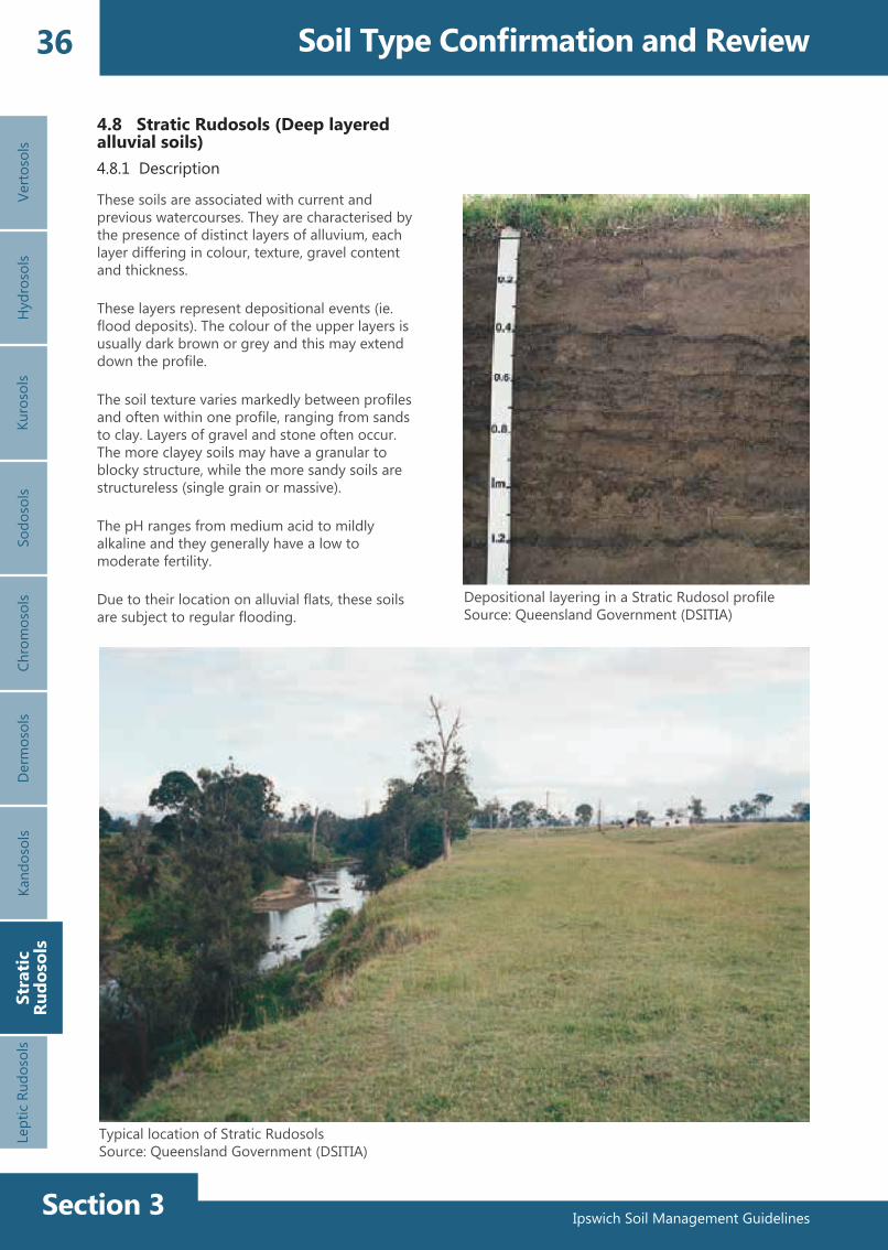
Ipswich Soil Management GuidelinesSection 3
36 Soil Type Confirmation and ReviewVe
rtoso
lsH
ydro
sols
Kuro
sols
Sodo
sols
Chro
mos
ols
Der
mos
ols
Stra
tic R
udos
ols
Lept
ic R
udos
ols
4.8 Stratic Rudosols (Deep layered alluvial soils)4.8.1 Description
Kand
osol
s
Depositional layering in a Stratic Rudosol profileSource: Queensland Government (DSITIA)
Stra
tic
Rudo
sols
Typical location of Stratic RudosolsSource: Queensland Government (DSITIA)
These soils are associated with current and previous watercourses. They are characterised by the presence of distinct layers of alluvium, each layer differing in colour, texture, gravel content and thickness.
These layers represent depositional events (ie. flood deposits). The colour of the upper layers is usually dark brown or grey and this may extend down the profile.
The soil texture varies markedly between profiles and often within one profile, ranging from sands to clay. Layers of gravel and stone often occur. The more clayey soils may have a granular to blocky structure, while the more sandy soils are structureless (single grain or massive).
The pH ranges from medium acid to mildly alkaline and they generally have a low to moderate fertility.
Due to their location on alluvial flats, these soils are subject to regular flooding.

Ipswich Soil Management Guidelines Section 3
37
Ipswich Soil Management Guidelines
VertosolsH
ydrosolsKurosols
SodosolsChrom
osolsD
ermosols
Stratic RudosolsLeptic Rudosols
Stratic Rudosols
Soil Property Behaviour of soil to activity or environment
Management responses/measures
Soil surface
These soils generally have a loose to firm surface.
Infiltration in these soils is generally rapid, particularly for the sandier soils with very little water running off.
Excessive cultivation or handling of these soils should be avoided.Soil structure and surface infiltration rate can be maintained through the incorporation of composted organic matter and by maintaining vegetative cover.Limit traffic and do not disturb unless necessary to avoid destruction of the soil structure.Construct gravel roads on the site and limit access off these roads.
Expansive clays
These soils contain little to no shrink swell clays.
Clay subsoils
These soils may contain sandy clays in layers in the profile.
Soils with clay layers may have reduced permeability, but generally the soils have highly permeable sand to loam textures throughout.
Dispersion
These soils are generally not dispersive.
The low cohesion of these generally sandy soils means they are susceptible to rill, sheet and stream bank erosion.
Maintain vegetative cover to reduce sheet and rill erosion.Stream bank erosion managed by maintaining vegetative cover and encouraging plants with fibrous root systems.
Salinity
These soils contain very low salt levels.
Low salt levels make them suitable for a wide range of plant types.
4.8.2 Stratic Rudosol characteristics
Soil Type Confirmation and ReviewKandosols

Ipswich Soil Management GuidelinesSection 3
38 Soil Type Confirmation and Review
Soil Property Behaviour of soil to activity or environment
Management responses/measures
Fertility
These soils generally have low to moderate fertility.
The generally sandy nature of the soils limits their ability to retain nutrients.
Fertiliser additions will improve plant growth, particularly nitrogen and phosphorus.To limit leaching/loss of nutrients, specific fertiliser rates should be divided up into regular smaller applications during the growing season, rather than one single application.Increasing organic matter content with composted organics will improve the fertility and assist nutrient retention in these soils.
Revegetation
These soils have dominantly neutral pH, are well drained, moderately fertile and have moderate plant available water holding capacity.
Plant species need be selected that are adapted to these conditions.
Relieve any compaction present and ensure adequate fertility for quick establishment (testing required).These soils could be watered deeply to encourage deep root growth (need to monitor moisture conditions).Protect surface with mulch material to reduce raindrop induced crusted or hardsetting surface.Stabilisation and revegetation targets and timeframes should be in accordance with IECA (2008) guidelines.
Soil handling
These soils generally have few soil handling constraints.
The objective of soil handling is to minimise off site impacts and maximise the productive capacity of the soil on site consistent with the intended use.
Compaction of loamy or sandy clays may require ripping prior to revegetation.Topsoil retention should be maximised, with separate storage of topsoil and subsoil stockpiles.To maintain soil structure, limit the handling of soil material and ensure traffic is concentrated on constructed road surfaces (reduce dust generation).Alluvial areas are prone to flooding, so ensure disturbance is conducted during periods of low flooding risk, and do not stockpile soil in this area.
Verto
sols
Hyd
roso
lsKu
roso
lsSo
doso
lsCh
rom
osol
sD
erm
osol
sSt
ratic
Rud
osol
sLe
ptic
Rud
osol
sKa
ndos
ols
Stra
tic
Rudo
sols

Ipswich Soil Management Guidelines Section 3
39
Ipswich Soil Management Guidelines
VertosolsH
ydrosolsKurosols
SodosolsChrom
osolsStratic Rudosols
Leptic Rudosols
Soil Type Confirmation and ReviewKandasols
4.9 Leptic Rudosols and Tenosols (Shallow stony soils)
4.9.1 Description
Leptic Rudosol overlying sandstoneSource: Queensland Government (DSITIA)
Derm
osolsKandosols
Leptic Rudosols
Typical location of Leptic RudosolsSource: Queensland Government (DSITIA)
These soils are generally shallow (< 0.30 m) and stony.
Soils may have a sandy, loamy or clayey texture. They will have a variable colour (depending on parent rock).
There is negligible to weak profile development except for some darkening of the surface soil due to accumulation of organic matter. Sometimes a pale subsurface layer or weakly developed subsoil horizon may be present.
The pH is generally neutral to moderately acid.
Plant available water capacity in the root zone is very low (< 50 mm).
Fertility varies with the composition of the parent rock, but is generally low.
They occur mostly on ridge crests and upper slopes (slopes up to 50%).

Ipswich Soil Management GuidelinesSection 3
40 Soil Type Confirmation and ReviewVe
rtoso
lsH
ydro
sols
Kuro
sols
Sodo
sols
Chro
mos
ols
Der
mos
ols
Stra
tic R
udos
ols
Lept
ic R
udos
ols
Kand
osol
s
4.9.2 Leptic Rudosol and Tenosol characteristics
Soil Property Behaviour of soil to activity or environment
Management responses/measures
Soil surface
These soils can have a range of surface conditions and textures, but all will be shallow and rocky.
Infiltration in these soils can range from rapid for sandy soils to slow for hardsetting or clay soils. These soils occur on crests and upper slopes which can be very steep leading to a high proportion of rainfall running off.
Surface infiltration rate can be increased through the incorporation of organic matter and by maintaining vegetative cover.
On steep slopes the erosion risk will be high with soil creep and water erosion a potential risk. Areas susceptible to mass movement include sloping lands of the Walloon Coal Measures Marburg Formation and the Tertiary basalts.
Reinstate surface rock where previously present to assist with erosion and sediment control.
Maintaining vegetative or some other form of cover may help to protect the soil from erosion.The risk of mass movement (ie. land slips) can often be reduced by retaining trees and avoiding land practices which increase the amount of water infiltrating the soil or its residence time in the landscape.
Expansive clays
These soils containing little to no shrink swell clays but depends on the rocks from which they have formed.
Clay subsoils
These soils will be shallow, rocky and generally do not contain clay subsoil material.
These soils are well drained because of their position on steep slopes and crests.
Where required, water diversion or drainage structures may reduce wet conditions at lower slope positions.
Dispersion
These soils are generally not dispersive.
Steep slopes and low cohesion of sandy soils are highly susceptible to soil creep, sheet and rill erosion. Clay soils are also susceptible to these forms of erosion.
Maintain cover to reduce soil creep, sheet and rill erosion.
Salinity
These soils contain very low salt levels.
Low salt levels make them suitable for a wide range of plant types, but the soils are shallow and rocky.
Lept
ic
Rudo
sols

Ipswich Soil Management Guidelines Section 3
41
Ipswich Soil Management Guidelines
VertosolsH
ydrosolsKurosols
SodosolsChrom
osolsD
ermosols
Stratic RudosolsLeptic Rudosols
Soil Type Confirmation and ReviewKandosols
Soil Property Behaviour of soil to activity or environment
Management responses/measures
Fertility
The fertility of these soils can range from very low to high.
Fertility of these soils is limited by their rockiness, soil depth and organic matter content. Clay soils with high organic content will have a higher fertility than sandy soils.
Fertiliser additions will improve plant growth, particularly nitrogen, phosphorus and potassium (depending on plants species selected).To limit leaching/loss of nutrients, specific fertiliser rates should be divided up into regular smaller applications during the growing season, rather than one single application.Increasing organic matter content with composted organics will improve the fertility and assist nutrient retention in these soils.
Revegetation
These soils have variable pH (slightly acid to slightly alkaline) are well drained, have very low to high fertility and low plant available water holding capacity.
Plant species need be selected that are adapted to these conditions.
These soils may require frequent, low volume watering due to the shallow profile depth.Increasing organic matter content with composted organics will improve the fertility, assist nutrient retention and improve moisture holding capacity in these soils.Relieve any compaction present and ensure adequate fertility for quick establishment (testing required).There is often minimal soil material available for revegetation purposes, soil material may need to be imported. Retain as much local soil as possible for use in rehabilitationIn steep areas, the placement of surface rocks to act as a terrace may assist the retention of topsoil material for plant growth.Stabilisation and revegetation targets and timeframes should be in accordance with IECA (2008) guidelines.
Soil handling
These soils are rocky and shallow.
The objective of soil handling is to minimise off site impacts and maximise the productive capacity of the soil on site consistent with the intended use.
Topsoil retention should be maximised.Retain all other soil material remaining after topsoil stripping.Reinstate surface rock where previously present.To maintain soil structure, limit the handling of soil material and ensure traffic is concentrated on constructed road surfaces to reduce dust generation. Leptic
Rudosols

Ipswich Soil Management GuidelinesSection 3
42
5.1 Erosion, drainage and sediment control requirements during and post construction
General Soil Management Principles
5.1.2 Erosion control
5.1.1 Drainage control
5.1.3 Sediment control
The following sections present some basic principles and methods for erosion, drainage and sediment control which apply to all soils in the Ipswich area (adapted from: Ipswich City Council, undated). Specific soil properties which are relevant to erosion and sediment control are identified and presented for each soil type. Erosion and Sediment Control should be undertaken in accordance with the Best Practice Erosion and Sediment Control books (IECA 2008).
Erosion control measures are essential in preventing on-site and off-site erosion effects and should be undertaken at all sites. Erosion control is often one of the cheapest control measures available.
Erosion control aims to prevent or reduce soil erosion caused mainly by rain splash and sheet erosion. The best form of erosion control is to maintain maximum cover on the soil surface, and minimise the “footprint” of soil disturbance at any one time. If plant cover is to be removed, typical erosion control measures may include:
• Bonded fibre matrix• Compost blankets• Erosion control blankets (ie. geofabrics, jute
matting)• Gravelling• Mulching• Revegetation (ie. turf)• Soil binders and surface stabilisers• Surface roughening.
Specific control measures will need to be selected depending on site conditions and project. Erosion controls are also required at entry and exit points at work sites where heavy vehicles transit frequently. These locations accumulate fine soil material which needs to be managed appropriately to prevent inappropriate off-site discharge.
Management of drainage water from areas immediately upslope and within the site needs to be considered when designing a site specific erosion and sediment control plan.
Considerations should include:• Diversion of up-slope stormwater runoff around
soil disturbances and controlled discharge away from the site
• Division of the work site into manageable drainage areas, and flow paths stabilised and managed. Dirty water is to be kept on site and disposed of appropriately (eg. into a sediment basin, flocculation and discharge of clean water)
• Minimise flow velocity and soil erosion within drainage channels and chutes (eg. regular spacing of check dams).
Sediment control measures are required to prevent off-site discharge of sediment laden waters. The aim is to retain all sediment on-site (both very fine and larger particles).
Typical sediment control measures include:• Buffer zones• Construction exits• Sediment fences• Sediment basins / weirs• Check dams• Grass filter traps• Rock filter traps• Compost/mulch berms• Drop inlet protection• Flocculants.
Specific control measures will need to be selected depending on individual site conditions.

Ipswich Soil Management Guidelines Section 3
43
Ipswich Soil Management Guidelines
General Soil Management Principles
5.2 Soil handling techniques and rehabilitation
Good rehabilitation starts in the planning phase of any activity. To achieve a high quality outcome it is essential to understand the properties of the soil and how they will interact with activities during construction and suitability for the intended final use.
• Understand your soils, their constraints and opportunities to achieve good rehabilitation outcomes
• During construction appropriate soil handling can minimise environmental impacts (eg. erosion) and increase site efficiency (eg. decreasing wet weather downtime).
Appropriate soil handling combined with an erosion and sediment control plan, soil amelioration, fertiliser additions, organic matter incorporation, and suitable plant selection, where appropriate, can improve the rehabilitation success (eg. vegetation establishment and reduced erosion).
Planning • What is the intended use of the site?• What earth works are to be undertaken?
Staging of the project works• Understand the characteristics of the soil
including the constraints and opportunities• Develop a soil management plan and erosion
and sediment control plan.
Construction• Suitable topsoil stripping and materials
handling to preserve maximum amount of topsoil and prevent contamination with less suitable subsoil material
• Staging construction to reduce time and area of exposed soil, and commence rehabilitation as soon as possible following completion of construction
• Stockpile location planning to eliminate double handling, avoid mixing of topsoil and subsoil and to preserve topsoil condition
• Protect stockpiles during construction phase to limit loss and cross contamination
• Reinstate soils in order they were removed (ie. topsoil above subsoil).
Rehabilitation• Fertiliser requirements (ideally based on
test results)• Soil amendments (eg. gypsum for sodic
clayey soils or lime for acid soils)• Measures to provide rapid protection of
the soil (ie. turf, soil stabilisation solutions, rock armouring, geofabric)
• Maintenance regime (ie. irrigation volume and frequency, periodic fertiliser application, weed control)
• Understand fundamental characteristics of the soil that are unable to be modified (ie. shrink-swell soils).

Ipswich Soil Management GuidelinesSection 3
44 Glossary
Term Definition
A horizon A1 horizon (topsoil, surface soil)
Mineral horizon at or near the surface with some accumulation of humified organic matter, usually darker in colour than underlying horizons and with maximum biological activity for any given soil profile (The National Committee on Soil and Terrain 2009).
A2 horizon (subsurface)
Mineral horizon having either, alone or in combination, less organic matter, sesquioxides or silicate clay than immediately adjacent horizons. It is usually differentiated from the A1 horizon by its paler colour, having a colour value at least one unit higher (The National Committee on Soil and Terrain 2009).
Acid soil Soil with a pH of less than 6.5 (Bruce and Rayment 1982).
Alkaline soil Soil with a pH greater than 7.4 (Bruce and Rayment 1982).
Alluvial terrace Former floodplain which either no longer floods or rarely floods due to deepening or enlargement of the stream channel.
Alluvium Sediment deposited by channelled or over-bank stream flow.
Ameliorate Substances added to the soil to improve its physical or chemical properties.
Australian Soil Classification (ASC)
This is a multi-category scheme with classes defined on the basis of diagnostic horizons or materials and their arrangement in vertical sequence as seen in an exposed soil profile (Isbell 2002).
B horizon (subsoil) Horizons consisting of one or more mineral soil layers characterised by one or more of the following: a concentration of silicate clay, iron, aluminium, organic material or several of these; a structure and/or consistence unlike that of the A horizons above or of any horizons below; stronger colours, usually expressed as higher chroma and/or redder hue, than those of the A horizons above or of those horizons below (The National Committee on Soil and Terrain 2009).
Bolus A small handful of soil which has been moistened to field capacity and kneaded into a ball which just fails to stick to the fingers when manipulated.
C horizon Layers below the solum (AB horizons/profile) of consolidated or unconsolidated material, usually partially weathered, little affected by pedogenic processes, and either like or unlike the material from which the solum presumably formed.
Ca:Mg Ratios of exchangeable Calcium (Ca) to exchangeable Magnesium (Mg) are used to support assessments of subsoil dispersibility where Ca:Mg <0.1 are often associated with highly dispersive subsoils.Ratio Rating<0.1 Very low0.1–1 Low1-2 Medium>2 High
Cation exchange capacity CEC is a measure of a soils capacity to hold and exchange cations influenced by factors such as organic matter, clay percentage and clay type and pH. Exchangeable Cations Classification (Hazelton and Murphy 2007)Cations Very Low Low Moderate High Very HighNa (meq/100 g) 0–0.1 0.1–0.3 0.3–0.7 0.7–2.0 >2K (meq/100 g) 0–0.2 0.2–0.3 0.3–0.7 0.7–2.0 >2Ca (meq/100 g) 0–2 2–5 5–10 10–20 >20Mg (meq/100 g) 0–0.3 0.3–1.0 1–3 3–8 >8
Clay Soil particles in the size range <0.002 mm.

Ipswich Soil Management Guidelines Section 3
45
Ipswich Soil Management Guidelines
Glossary
Term Definition
Clay mineralogy Most clay minerals are a mixture of oxygen, aluminium and silicon elements. Clays are divided into groups based on the number of sheets of silicon and aluminium. Kandites have 1 silicon and 1 aluminium (non-shrink swell clays), Smectites have 2 silicon and 1 aluminium (shrink swell clays) (Singer and Munns 1996).
Cohesion Attraction between soil particles
Colluvium Unconsolidated, poorly sorted soil and rock material transported largely by gravity (i.e. mass movement), deposited on lower slopes.
Colwell P A measure of available soil phosphorus using a bicarbonate extractable method.
Compaction Physical process that decreases soil pore spaces and increase bulk density.
Compost Decomposed organic matter
Dispersion Process of separation of soil aggregates into individual particles, usually in water.
Dispersion potential The dispersion potential of soil is an indicative rating based on factors including ESP, Ca:Mg ratios, salinity, pH, particle size, and clay mineralogy. Where available an Emerson Class Test is used to indicate the potential for clay dispersion.
Electrical conductivity (EC) Measure of concentration of electrically charged water soluble salts (in a 1:5) soil water suspension. Used to quantify soil salinity. See ‘Salinity’ for rating table.
Erosion potential The degree of erosion potential given inherent soil characteristics without considering slope, cover or land use. Erosion Potential (modified after Hazelton and Murphy 2007):Hazard Class Description of ClassLow The combination of soil characteristics is such that minimal
erosion damage will take place, i.e. no wind or water erosion.Moderate Significant short-term erosion (i.e. occasional rills, no gullies) will occur
as a result of soil characteristics. Control can be obtained with structural works, topsoiling, vegetative techniques and by phasing development.
High Major erosion and in some cases long-term erosion (ie. formation of rills and gullies is common), can be expected to take place. Control of this erosion will require the adoption of intensive soil conservation works. Even with intensive short-term and long-term soil conservation works, significant erosion and soil loss would occur from this class of land when disturbed.
Expansive clays Soils that contain Smectite clay minerals (2:1 clays). These soils can change volume, such that they shrink when they dry and swell when wet, because the clay crystals expand and contract as water enters or leaves the clay interlayer spaces.
Fertility (plant nutrients) Soil fertility (the capacity of the soil to support plant growth in a given climatic regime) is a function of the physical, chemical and biological characteristics of the soil. Indices used include Total Carbon, Cation Exchange Capacity (CEC), exchangeable cations, Total Kjeldahl nitrogen (TKN) and available phosphorus (Colwell P), sulfur (KCl Extractable S) and potassium (Exchangeable K).Some soil nutrient level ratings from Bruce and Rayment (1982) and Rayment and Bruce (1984) include:Analyte Very Low Low Moderate High Very HighTKN (%) <0.05 0.05–0.15 0.15–0.25 0.25–0.5 >0.5Colwell P (mg/kg) <10 10–20 >20–40 >40–100 >100Sulfate Sulfur (mg/kg) <5 5–10 10–20 20–100 >100Extr. K (cmol+/Kg) <0.1 0.1–0.2 0.2–0.5 0.5–1.0 >1.0Exch. K (cmol+/Kg) <0.1 0.1–0.2 0.2–0.5 0.5–1.0 >1.0Total Carbon (%) <0.5 0.5–1.5 >1.5–2.5 >2.5–5.0 >5.0Nitrate (mg/kg) <5 5–10 10–25 25–50 >50

Ipswich Soil Management GuidelinesSection 3
46 Glossary
Term Definition
Horizon A layer within the soil profile with morphological characteristics and properties different from layers below and /or above it.
Infiltration Entry of water into the soil.
Leaching The removal of soluble materials dissolved in soil solution
Modified Emerson Aggregate Test (MEAT)
Clay dispersion is semi-quantitatively measured using the Modified Emerson Aggregate Test. This test measures the instability of soil structure when immersed in water (Emerson 1967).Modified Emerson Class (Lovedale and Pyle 1973).Emerson Class DefinitionClass 1 Worked bolus material disperses.Class 2 Aggregates disperse (cloudy solution).Class 3 Aggregates slake.Class 4 No change to aggregate – non-dispersive.
Mottles The presence of more than one soil colour in the same soil horizon. Mottles are the subdominant colours.
Ped A natural soil structure aggregate.
Plant available water capacity Amount of soil water stored between the field capacity (soil water content where water ceases to drain readily from the soil) and plant wilting point. Usually expressed as an equivalent depth of rainfall in mm.
Sand Soil particles in the size range >0.02–2.0 mm.
Silt Soil particles in the size range 0.02–0.002 mm.
Salinity Salinity is the presence of soluble salts in soils, mainly Ca2+, Mg2+, Na+, Cl-, SO42- and HCO3.Salinity Ratings (DERM 2011)Soil Salinity Rating EC1:5 (dSm-1) 10–20% Clay 20–40% Clay 40–60% Clay 60–80% ClayVery low <0.07 <0.09 <0.12 <0.15Low 0.07–0.15 0.09–0.19 0.12–0.24 0.15–0.3Medium 0.15–0.34 0.19–0.45 0.24–0.56 0.3–0.7High 0.34–0.63 0.45–0.76 0.56–0.96 0.7–1.18Very high 0.63–0.93 0.76–0.1.21 0.96–1.53 1.18–1.87Extreme >0.93 >1.21 >1.53 >1.87
Soil Chloride Ratings (Rayment and Bruce 1984) Very Low Low Medium High Very HighChloride (mg/kg) <100 100–300 300–600 600–2000 >2000

Ipswich Soil Management Guidelines Section 3
47
Ipswich Soil Management Guidelines
Glossary
Term Definition
Sodic soil/sodicity Sodicity is a measure of exchangeable sodium (Na) in proportion to other exchangeable cations. Fine earth material with an ESP of 6 or greater is defined as sodic. Samples with total CEC measurements of <10 cmol+/Kg are generally unreliable for this assessment.Sodicity/ESP Ratings (Northcote and Skene 1972)Sodicity Rating ESPs (%)Non-sodic 0–6sodic 6–15Strongly sodic >15
Soil horizon A soil horizon is a layer of soil, approximately parallel to the surface, with morphological properties different from layers below and/or above it; the layers are further designated according to properties such as location in the profile and properties described that reflect soil forming processes; major soil horizon designations include A1 (surface), A2 (below A1and paler in colour than A1, B1 (transition between A and B), B2 (subsoil below).
Soil pH Soil pH can be used as an indicator of the chemical processes that occur in a soil – that is, can indicate certain nutrient deficiencies and toxic effects, which may have implications for soil management and rehabilitation measures.pH Classification (Bruce and Rayment 1982)pH Rating>9.0 Very strongly alkaline9.0–8.5 Strongly alkaline8.4–7.9 Moderately alkaline7.8–7.4 Mildly alkaline7.3–6.6 Neutral6.5–6.1 Slightly acid6.0–5.6 Moderately acid5.5–5.1 Strongly acid5.0–4.5 Very strongly acid
Soil profile Vertical section of soil from the soil surface through all of its horizons to parent material, consolidated substrate or unconsolidated material.
Soil structure Soil structure refers to the size, shape and strength of natural soil aggregates.
Soil texture (field texture) The size distribution of particles finer than 2 mm, reflected in the behaviour of a small handful of moistened soil kneaded into a ball (Bolus) and/or ribbon.
Subsoil Subsoil is a commonly used term used to identify soil material below the topsoil (A horizons) and is usually comprised of B horizons.
Weathering The chemical or physical breakdown of rocks and minerals. It may take the form of disintegration into smaller pieces of rock, or chemical weathering where minerals are converted and removed in soil solution.

Ipswich Soil Management GuidelinesSection 3
48 References
Bruce RC and Rayment GE 1982. Analytical methods and interpretations used by the Agricultural Chemistry Branch and land use surveys. Queensland Department of Primary Industries, Brisbane.
Carey B 2014. Understanding dispersive soils. Landcare Queensland (www.landcare.org.au).
Charman PEV and Murphy BW (eds.) 2007. Soils : their properties and management, 3rd edition, Oxford University Press, South Melbourne, Victoria.
Department of Environment and Resource Management (DERM) 2011. Salinity Management Handbook, Second edition, DNRQ97109 #28823, DERM, Brisbane.
Emerson WW 1967. A classification of soil aggregates based on their coherence in water. Australian Journal of Soil Research, 5: 47-57.
Field DJ, McKenzie DC and Koppi AJ 1997. ‘Development of an improved Vertosol stability test for SOILpak’, Australian Journal of Soil Research 35, 843–852.
Harms BP 1996. Field Manual, in Noble, K.E. (ed) Understanding and Managing Soils in the Moreton Region, Department of Primary Industries Training Series QE96003, Brisbane.
Harms BP and Claridge J 2001. Understanding Soils – Soil Information Workshops 1997-2000. QNRM01067, Department of Natural Resources and Mines, Brisbane.
Hass CA 1987. Evaluation of Agricultural Land Suitability Moreton Shire, Queensland Department of Primary Industries Project Report Q087013, Brisbane.
Hazelton P and Murphy B 2007. Interpreting Soil Test Results: What do all the numbers mean? CSIRO Publishing, Australia.
International Erosion Control Association (IECA) 2008. Best Practice Erosion and Sediment Control. Books 1 – 3.
Ipswich City Council. (Undated). Soils of Ipswich – Field Guide. Erosion and soil types. Ipswich City Council (www.ipswich.qld.gov.au).
Ipswich Rivers Improvement Trust / Ipswich City Council (IRIT / ICC) 2014. Soils map of Ipswich. Ipswich Rivers Improvement Trust / Ipswich City Council, Ipswich.
Isbell RF 2002. The Australian Soil Classification. CSIRO Publishing, Australia.
Loveday J and Pyle J 1973. The Emerson Dispersion Test and its relationship to hydraulic conductivity. CSIRO Australian Division of Soils Technology 15, 1-7.
McLaren RG and Cameron KC 1996. Soil science: sustainable production and environmental protection, New ed, Oxford University Press, Auckland.
Munsell Color 2010. Munsell Soil-Color Charts. Munsell Color, Minnosota.
Northcote KH and Skene JKM, 1972. Australian Soils with saline and sodic properties, Soil Publication No. 27. CSIRO, Melbourne.
QLD Government (DSITIA). Department of Science, Information, Technology, Innovation and the Arts.
Rayment GE and Bruce RC 1984. Soil testing and some soil test interpretations used by the Queensland Department of Primary Industries. Queensland Department of Primary Industries, Brisbane.
Singer MJ and Munns DN 1996. Soils: an introduction 3rd Ed. Prentice-Hall. New Jersey.
Stace HCT, Hubble GD, Brewer R, Northcote KH, Sleeman JR, Mulcahy MJ, Hallsworth EG 1968. A handbook of Australian soils. Rellim Technical Publications for the CSIRO and the International Society of Soil Science, Glenside, South Australia.
Standards Australia. AS 1289.C8.1-1980: Methods of testing soils for engineering purposes - Soil classification tests - Dispersion - Determination of Emerson class number of a soil.
The National Committee on Soil and Terrain 2009. Australian Soil and Land Survey Field Handbook, 3rd Edition, CSIRO Publ., Collingwood, VIC.

Ipswich Soil Management GuidelinesIpswich Soil Management Guidelines © 2014 Ipswich City Council and Ipswich Rivers Improvement Trust