Embed Size (px)
Citation preview
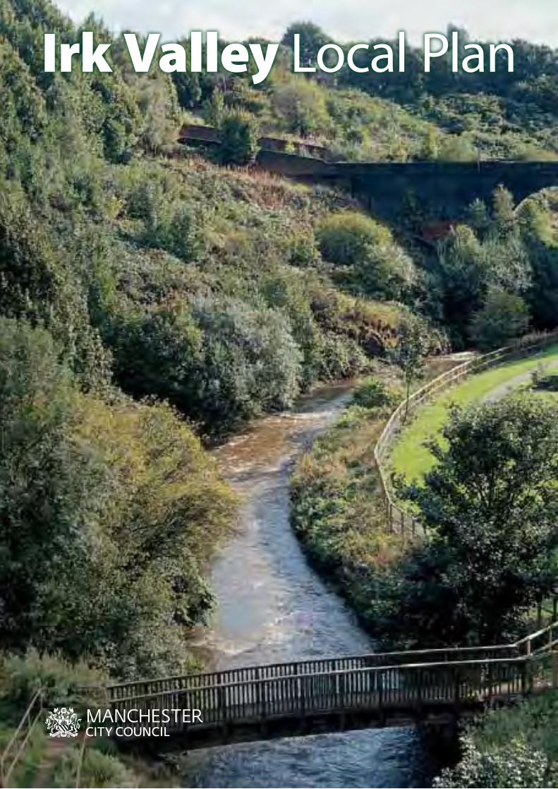
Irk Valley Local Plan

iiSection
ContentsApproval .................................................................................................. iiiAcknowledgements ........................................................................... iiiAbbreviations ........................................................................................ivGlossary ....................................................................................................v
1. INTRODUCTION .......................................................11.1 Study area ..............................................................................21.2 Purpose of the Irk Valley Local plan ..........................11
2. STRATEGIC CONTEXT ...........................................132.1 Policy context ....................................................................14
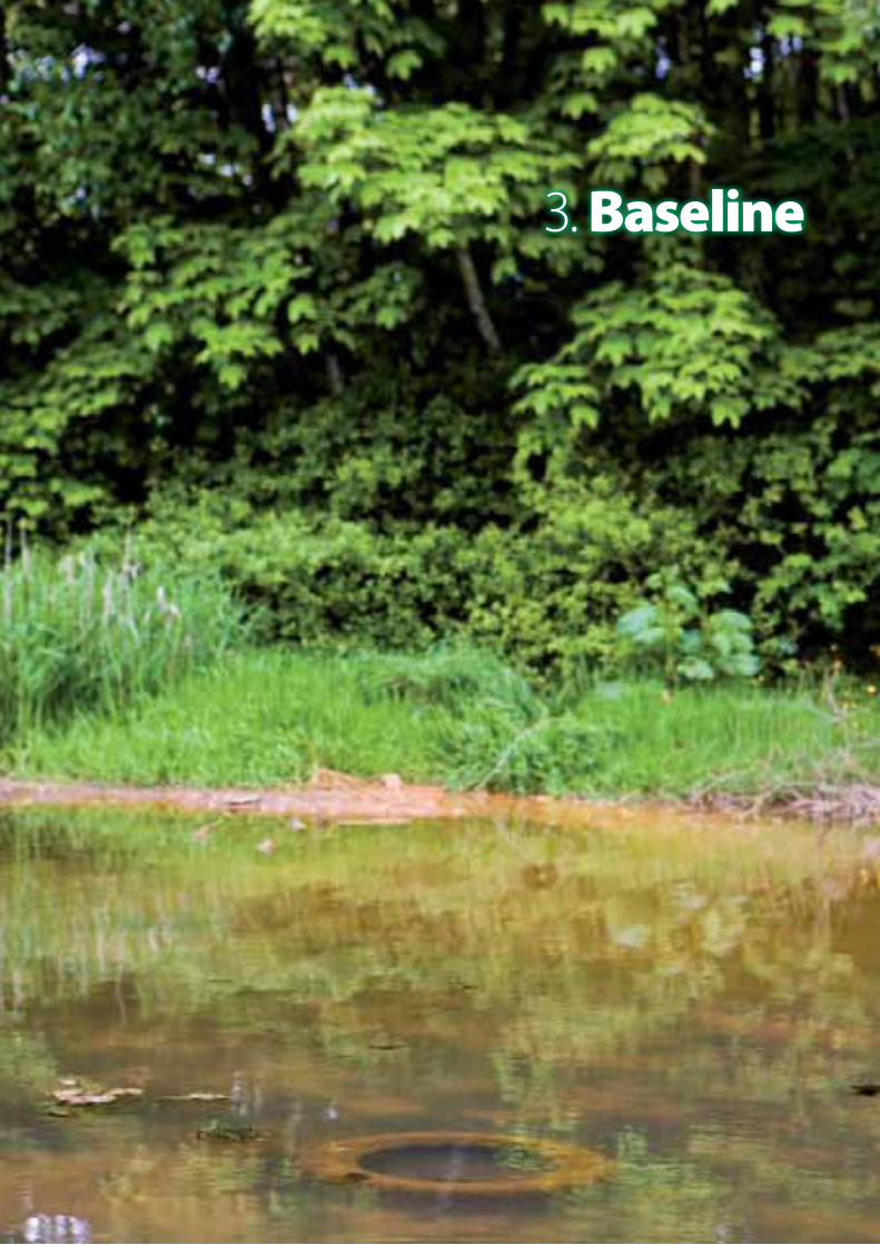
3. BASELINE .................................................................173.1 Ownership and management of open spaces ....183.2 Local action and community involvement .......... 293.3 Baseline conclusions ...................................................... 32
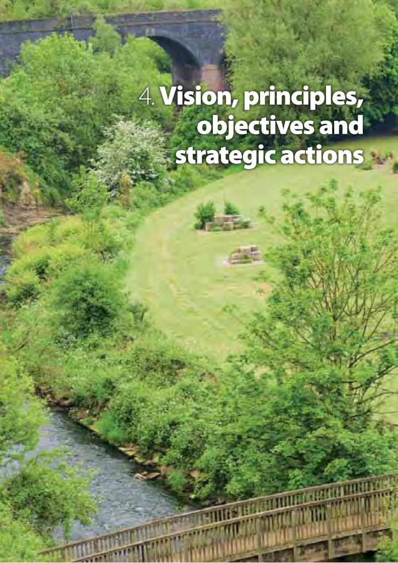
4. VISION, PRINCIPLES, OBJECTIVES and STRATEGIC ACTIONS ........................................... 334.1 Vision .................................................................................... 344.2 Principles, objectives and actions ............................ 35
5. LOCAL PLAN-wIDE POLICy.................................415.1 Safeguarding sites ............................................................425.2 New or enhanced open space provision ...............425.3 Accessibility and safety ................................................. 435.4 Children’s play space ...................................................... 435.5 Nature, conservation and biodiversity ................... 445.6 Vacant or derelict land .................................................. 445.7 Waterways .......................................................................... 455.8 Industrial, commercial and residential uses along the river valley ...................................................... 455.9 Regional park recreation provision ......................... 46
6. DELIVERING THE IRK VALLEy REGIONAL PARK SySTEM ................................... 476.1 Overcoming the main challenges ............................ 486.2 Delivering the regional park spatial framework .... 506.3 Delivery mechanisms and responsibilities ........... 566.4 Performance and monitoring .................................... 576.5 Implementation plan ..................................................... 58
7. COST REPORT .........................................................617.1 Introduction.................................................................... 627.2 Scheduled scope of works ....................................... 637.3 Overall costs, including maintenance costs ...... 64
8. SUMMARy .............................................................. 658 Summary.......................................................................... 66
9. APPENDIX 9 Appendix Area Action Plans .....................................67
LIST OF TABLES Table 3.1 Management levels within the Irk Valley ...........21Table 3.2 Revenue expenditure on MCC-owned Irk Valley sites ................................................................ 27Table 3.3 Active stakeholders in the Irk Valley ....................31Table 6.1 Performance indicators ............................................ 57Table 6.2 Generic strategic actions ......................................... 58
LIST OF FIGURESFigure 1 Study area location map .............................................3Figure 2 Local plan areas ..............................................................4Figures 3, 4 and 5 Topographic assessment: terrain, elevation, slope and flood risk characteristics ........................6Figure 6 Index of Multiple Deprivation 2004 .......................8Figure 7 Landfill sites ......................................................................9Figure 8 Natural and cultural heritage features in the Irk Valley ...........................................................................10Figures 9 and 10 Current ownership and management ...............19Figure 11 Manchester City Park management areas ....... 24Figure 12 Management levels .................................................... 25Figure 13 Comparing management responsibilities situation with the overall quality of open space 28Figure 14 Connectivity strategy .................................................37Figure 15 Linkage strategy – location of Irk Valley trail, key access routes and gateways ........................... 53Figure 16 Broad ecological habitats ........................................ 54Figure 17 The Irk Valley Regional Park network ..................55
iii Irk Valley Local Plan – North Manchester Approval and Acknowledgements
LIST OF AREA ACTION PLAN MAPS Map of Area Action Plans ..................... 69Area Action Plan 1: Lower Irk Valley link – city centre
to Smedley Dip ..........................................76Area Action Plan 2: Lower to Middle Irk Valley – Smedley
Dip and Queens Park ............................. 83Area Action Plan 3: Middle Irk Valley – Harpurhey
Reservoirs and Ponds ............................ 89Area Action Plan 4: Middle to Upper Irk Valley – Waterloo
Street to Delaunays Road..................... 96Area Action Plan 4: Middle to Upper Irk Valley –
Delaunays Road to Bowker Vale ....... 97Area Action Plan 5: Blackley Forest ........................................102Area Action Plan 6: Higher Blackley –
Alconbury Walk .....................................109Area Action Plan 6: Higher Blackley –
Nutbank Common .................................110Area Action Plan 7: Higher Blackley – Plant Hill Park,
Tweedle Common, French Barn Lane ...................................................117
Area Action Plan 8: Boggart Brook – Boggart Hole Clough, Shackliffe Green, Bailey’s Wood ......123
Area Action Plan 9: Broadhurst Park and Lower Broadhurst Clough ...............................129
Area Action Plan 10: Lightbowne Country Park .................134Area Action Plan 11: Moston Vale ............................................. 139Area Action Plan 12: Lower Moston Brook –
new link from Moston Vale to Queens Park .............................................144
Area Action Plan 13: Moston Railway Sidings ......................150Area Action Plan 14: Broadway Common .............................156
ApprovalManchester City Council Executive Committee approved the plan on 17 January 2007. Factual updates have been incorporated into this published in March 2010 version where appropriate.
Acknowledgements Ordnance Survey data
All data captured was based on Ordnance Survey Landline 1:1250-scale mapping. Crown Copyright reserved. Licence No 100019568.
Landfill data
The locations of the landfill are indicated on Figure 8. It must be emphasised that the boundary marked represents the limit of the site on which land filling operations were assumed to have taken place, and does not necessarily show the extent of actual infill. It cannot therefore be assumed either that the entire site was filled or that there was no filling or over-spill beyond the marked boundary.
This Council has taken all reasonable precautions to ensure the information supplied is correct. However, the Council, its officers, servants and agents, will not accept any liability for loss or damage caused by any person relying on this information, or for any errors or omissions in the information provided.
ivSection
AGMA Association of Greater Manchester Authorities
AMAS Association of Manchester Allotment Societies
ANGST Accessible Natural Green Space Standard
BAP Biodiversity Action Plan
BV Best Value
CIC Community Interest Company
COAs Census Output Areas
DEFRA Department of Environment, Food and Rural Affairs
DfT Department of Transport
EA Environment Agency
GIS Geographical Information System
GMPTE Greater Manchester Passenger Transport Executive
Ha Hectares
HMR Housing Market Renewal
IDeA Improvement and Development Agency
IVPO Irk Valley Project Officer
LAP Local Area for Play
LDF Local Development Framework
LEAP Local Equipped Area for Play
LNR Local Nature Reserve
LSPs Local Strategic Partnerships
MASL Metres Above Sea Level
MCC Manchester City Council
MEU AGMA Ecology Unit
NEAP Neighbourhood Equipped Area for Play
NGOs Non-Governmental Organisations
NLUD National Land Use Database
NMR North Manchester Regeneration
NPFA National Playing Fields Association
NwDA North West Development Agency
NwRA North West Regional Assembly
ODPM Office of the Deputy Prime Minister
PAOS Publicly Accessible Open Space
PI Performance Indicator
PPG 9 Planning Policy Guidance Note 9: Nature Conservation
PPG 17 Planning Policy Guidance Note 17: Sports, Open Space and Recreation
PPG 25 Planning Policy Guidance Note 25: Development and Flood Risk
PROw Public Right of Way
RPG 13 Regional Planning Guidance 13 – North West Region
SBI Site of Biological Interest
SRFNM A Strategic Regeneration Framework for North Manchester
SUDs Sustainable Urban Drainage Systems
UDP Unitary Development Plan
UGSTF Urban Green Space Task Force
wFD Water Framework Directive
Abbreviations
v Irk Valley Local Plan – North Manchester
Activity zone an area of land specifically dedicated for children to use for play. It may or may not include play equipment.
Ancient woodland is designated as land that has been continuously wooded since AD1600 in England and Wales. The ancient woodland inventory database is compiled by English Nature.
Flood zones replaced the ‘Indicative floodplain’ maps in July 2004 in accordance with PPG 25. The natural floodplains are divided into three zones; Flood Zone 3 shows the likely extent of a 1:100 year flood event. Zones 1 and 2 identify the extent of a 1:1000 year event.
Green chains are areas of linked, but separate, open spaces clearly connected by signed public footpaths.
Green corridors refer to the relatively continuous areas of open space leading through the built environment. These may not be publicly accessible but allow wildlife and plants to spread between them.
Green Flag Award Scheme is awarded by the Civic Trust and represents a national standard for parks and green spaces. It provides a benchmark against which the quality of freely accessible provision can be measured. It is based on eight broad criteria, which were defined after extensive consultation with organisations concerned with nature conservation, public safety, community health, education and children’s play.
Green space refers to areas in the urban environment, which are not built on and consist of unsealed, permeable, soft surfaces such as soil, grass, shrubs, and trees. It can include parks, play fields, gardens, allotments, cemeteries, road verges and natural or semi-natural areas which may or may not be accessible to the general public for recreational purposes or for nature conservation.
Green roofs is a term used to describe vegetated roofs on buildings often replacing the vegetated footprint that was destroyed when the building was constructed. They can take many different forms, but often they are limited to herbs, grasses, mosses and drought-tolerant succulents such as Sedum, which can be sustained in a substrate layer as shallow as 2.0 cm. They require minimal maintenance and are generally not accessible to the public. Apart from the benefit to biodiversity and
improving the urban environmental setting, they can also act as SUDs, improving storm water management, and reduce the building’s energy consumption.
Local area for play (LAP) is a small area of open space specially designated and laid out for young children to play, close to where they live. It provides essential play opportunities for toddlers and young children in locations that are overseen by parents.
Local equipped area for play (LEAP) is a piece of open space that is designated and equipped for children of early school age.
Natural or semi-natural open space (also referred to as naturalistic, wild sites, or informal open spaces). Areas whose current primary benefit is the contribution they provide to ecology or breaking up urban areas. They can include designated nature conservation sites such as river corridors or land that is not currently developed such as canal corridors, railway routes, verges alongside roads, and former tips and quarries. This type of environment can fulfil a passive recreation role for the benefit of the local community and biodiversity.
Neighbourhood equipped area for play (NEAP) is a site that is designated and equipped mainly for older children, but with opportunities for play for younger children too. Located within a walking time of 15 minutes from home, this playground type is the largest of three types of play area based on the NPFA standards.
Public right of way (PROw) are ‘local rights of way’ as defined in section 60(5) of the Countryside and Rights of Way Act 2000 as including footpaths, cycle tracks, bridleways, restricted byways and byways open to all traffic.
Publicly accessible open space (PAOS). A term adopted here to include all sites, irrespective of ownership, which are accessible to the public. Traditionally the term ‘Public Open Space’ has tended to include only local authority owned and managed sites. The Irk Valley has several sites that are privately owned but where agreements exist, or have the potential to exist, which stipulate that they should be managed as sites with public access.
Abbreviations and Glossary
Glossary

viSection
River basin is the area of land from which all surface run-off flows through a sequence of streams, rivers and, possibly, lakes into the sea at a single river mouth, estuary or delta.
River basin district is the area of land and sea, made up of one or more neighbouring river basins together with their associated ground waters and coastal waters, which is identified under Article 3(1) of the EU directive on waterways, as the main unit for management of river basins.
Source protection zones are protection zones around groundwater sources, which are used for public water supply (defined by the Environment Agency). Within these zones, certain activities and processes are prohibited or restricted. Zone II (Outer Protection Zone) is defined by the 400-day travel time or 25 per cent of the source catchment area, whichever is larger. The travel time is derived from consideration of the minimum time required to provide delay, dilution and attenuation of slowly degrading pollutants.
Super output area is a small geographical boundary set by the Office of National Statistics UK to report local level statistics, particularly the census. They were developed to ensure consistency in reporting statistics over time. A lower level super output area consists of a minimum population of 1,000 people.

1. Introduction
2 Irk Valley Local Plan – North Manchester
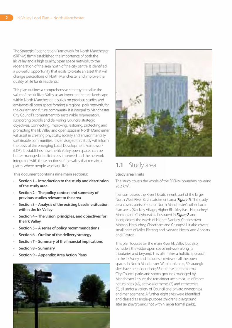
The Strategic Regeneration Framework for North Manchester (SRFNM) firmly established the importance of both the Irk Valley and a high quality, open space network, to the regeneration of the area north of the city centre. It identified a powerful opportunity that exists to create an asset that will change perceptions of North Manchester and improve the quality of life for its residents.
This plan outlines a comprehensive strategy to realise the value of the Irk River Valley as an important natural landscape within North Manchester. It builds on previous studies and envisages all open space forming a regional park network, for the current and future community. It is integral to Manchester City Council’s commitment to sustainable regeneration, supporting people and delivering Council’s strategic objectives. Connecting, improving, restoring, protecting and promoting the Irk Valley and open space in North Manchester will assist in creating physically, socially and environmentally sustainable communities. It is envisaged this study will inform the basis of the emerging Local Development Framework (LDF). It establishes how the Irk Valley open spaces can be better managed, derelict areas improved and the network integrated with those sections of the valley that remain as places where people work and live.
This document contains nine main sections:
• Section 1 – Introduction to the study and description of the study area
• Section 2 – The policy context and summary of previous studies relevant to the area
• Section 3 – Analysis of the existing baseline situation within the Irk Valley
• Section 4 – The vision, principles, and objectives for the Irk Valley
• Section 5 – A series of policy recommendations
• Section 6 – Outline of the delivery strategy
• Section 7 – Summary of the financial implications
• Section 8 – Summary
• Section 9 – Appendix: Area Action Plans
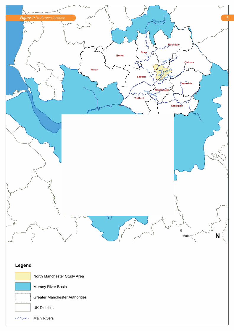
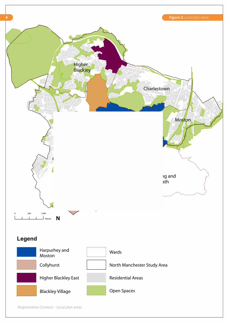
1.1 Study areaStudy area limits
The study covers the whole of the SRFNM boundary covering 26.2 km2.
It encompasses the River Irk catchment, part of the larger North West River Basin catchment area (Figure 1). The study area covers parts of four of North Manchester’s other Local Plan areas (Blackley Village, Higher Blackley East, Harpurhey/Moston and Collyhurst) as illustrated in Figure 2, and incorporates the wards of Higher Blackley, Charlestown, Moston, Harpurhey, Cheetham and Crumpsall. It also covers small parts of Miles Platting and Newton Heath, and Ancoats and Clayton.
This plan focuses on the main River Irk Valley but also considers the wider open space network along its tributaries and beyond. This plan takes a holistic approach to the Irk Valley and includes a review of all the open spaces in North Manchester. Within this area, 39 strategic sites have been identified; 33 of these are the formal City Council parks and sports grounds managed by Manchester Leisure; the remainder are a mixture of more natural sites (48), active allotments (7) and cemeteries (9), all under a variety of Council and private ownerships and management. A further eight sites were identified and classed as single-purpose children’s playground sites (ie. playgrounds not within larger formal parks).
Wigan
BoltonBury
Oldham
Rochdale
Salford
Trafford
Stockport
Tameside
Manchester
River Irwell
River Irk
River Mersey
River Weaver
Medlock RiverMoston Brook
Study Area Location Map
Legend
North Manchester Study Area
Mersey River Basin
Greater Manchester Authorities
UK Districts
Main Rivers
0Meters N
3Figure 1: Study area location
Cheetham
Higher Blackley
Moston
Harpurhey
Crumpsall
Charlestown
Miles Platting and Newton Heath
Regeneration Context – Local plan areas
Legend
Harpurhey and Moston
Collyhurst
Higher Blackley East
Wards
North Manchester Study Area
Residential Areas
Open Spaces
0 1,000500
Metres
Blackley Village
N
4 Figure 2: Local plan areas
5Introduction
Physical environment
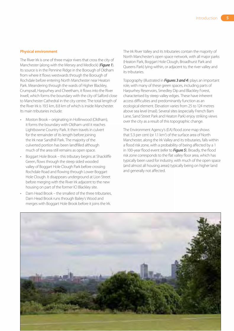
The River Irk is one of three major rivers that cross the city of Manchester (along with the Mersey and Medlock) (Figure 1). Its source is in the Pennine Ridge in the Borough of Oldham from where it flows westwards through the Borough of Rochdale before entering North Manchester near Heaton Park. Meandering through the wards of Higher Blackley, Crumpsall, Harpurhey and Cheetham, it flows into the River Irwell, which forms the boundary with the city of Salford close to Manchester Cathedral in the city centre. The total length of the River Irk is 19.5 km, 8.8 km of which is inside Manchester. Its main tributaries include:
• Moston Brook – originating in Hollinwood (Oldham), it forms the boundary with Oldham until it reaches Lightbowne Country Park. It then travels in culvert for the remainder of its length before joining the Irk near Sandhill Park. The majority of the culverted portion has been landfilled although much of the area still remains as open space.
• Boggart Hole Brook – this tributary begins at Shackliffe Green, flows through the steep sided wooded valley of Boggart Hole Clough Park before crossing Rochdale Road and flowing through Lower Boggart Hole Clough. It disappears underground at Lion Street before merging with the River Irk adjacent to the new housing on part of the former ICI Blackley site.
• Dam Head Brook – the smallest of the three tributaries, Dam Head Brook runs through Bailey’s Wood and merges with Boggart Hole Brook before it joins the Irk.
The Irk River Valley and its tributaries contain the majority of North Manchester’s open space network, with all major parks (Heaton Park, Boggart Hole Clough, Broadhurst Park and Queens Park) lying within, or adjacent to, the river valley and its tributaries.
Topography (illustrated in Figures 3 and 4) plays an important role, with many of these green spaces, including parts of Harpurhey Reservoirs, Smedley Dip and Blackley Forest, characterised by steep valley edges. These have inherent access difficulties and predominantly function as an ecological element. Elevation varies from 25 to 124 metres above sea level (masl). Several sites (especially French Barn Lane, Sand Street Park and Heaton Park) enjoy striking views over the city as a result of this topographic change.
The Environment Agency’s (EA) flood zone map shows that 5.3 per cent (or 1.1 km2) of the surface area of North Manchester, along the Irk Valley and its tributaries, falls within a flood risk zone, with a probability of being affected by a 1 in 100-year flood event (refer to Figure 5). Broadly, the flood risk zone corresponds to the flat valley floor area, which has typically been used for industry, with much of the open space (and almost all housing areas) typically being on higher land and generally not affected.
65
70
75
80
85
90
60
95
55
50
45
40
35
30
105
60
100
70
65
105
90
100
50
75
85
110
65
70 100
70
11085
75
35
100
60
100
80
95100
80
70
100
100
55
45
95
50
90
65
85
75
65
75
50
105
110
55
40
100
95
100
40
70
50
9590
90
80
85
40
110
30
105
90
100
8095
Legend
Elevation
High : 124 masl
Low : 25 masl
Open Spaces
5 m Contours
Rivers
0 1,000
Metres
N
Terrain and elevation
Figure 3a
Figure 3b
Legend
% Slope
High : 40.9
Low : 0.0
North Manchester Study Area
Open Spaces
Rivers
Slope and steepness
Figure 3c
Flood risk zones
Legend
100 Year Return Flood
North Manchester Study Area
Residential Areas
Open Spaces
Rivers
6 Figures 3, 4 and 5: Topographic assessment: terrain, elevation, slope and flood risk characteristics
7Introduction
Socio-economic
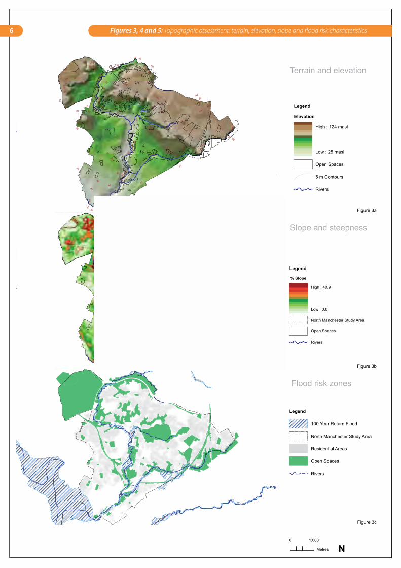
Parts of North Manchester are some of the most deprived in England as illustrated by the Index of Multiple Deprivation 2004 (ODPM 2004); the majority of super output area neighbourhoods (Office of National Statistics 2003) are in the bottom 5 per cent, with seven areas, primarily in the Lower Harpurhey and Collyhurst area, being within the bottom 1 per cent of this category (Figure 6). This highlights the need for regeneration of the area. Open space has an important role to play in the regeneration process by promoting greater social inclusion and enhancing the quality of the local environment.
Industrial legacy
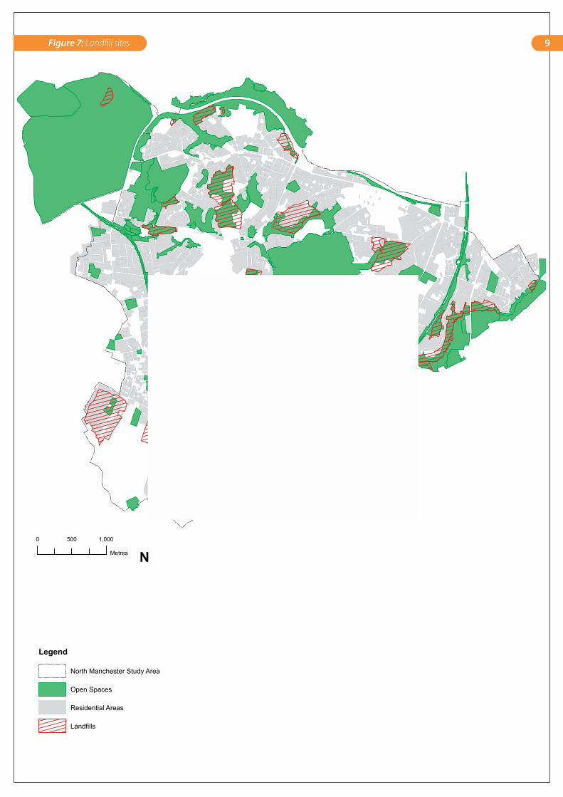
Historically, the Irk Valley was used as a location for industry, some of which still remains. This is due to its relatively flat nature and access to water. With the decline in industry, many of the former industrial sites along the river valley have become derelict and are evolving into semi-natural landscapes or are in the process of being developed. Many of these are likely to be contaminated due to previous use such as the Harpurhey Reservoirs site. In addition, many of the open spaces are former landfill sites (Figure 7) including Shackliffe Green, Tweedle Common and French Barn Lane, Moston Vale and Ashley Lane Park, Lightbowne Country Park, Sand Street, Sandhills, Harpurhey Reservoirs and Factory Lane Slopes, among others. This landfilling creates ongoing management issues and may prevent future uses other than green space.
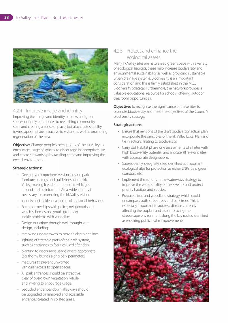
Land not suitable for development, due to topographic constraints (eg. French Barn Lane site), makes up a significant portion of the open space provision in North Manchester. The unmanaged nature of some of these sites has created a sense of abandonment that has affected people’s perception of the area. Many of these have the potential to be significant assets and it is necessary to realise their potential. The negative image is also due to problems with vandalism, perception of crime and illegal fly-tipping found across some of the valley’s open spaces.
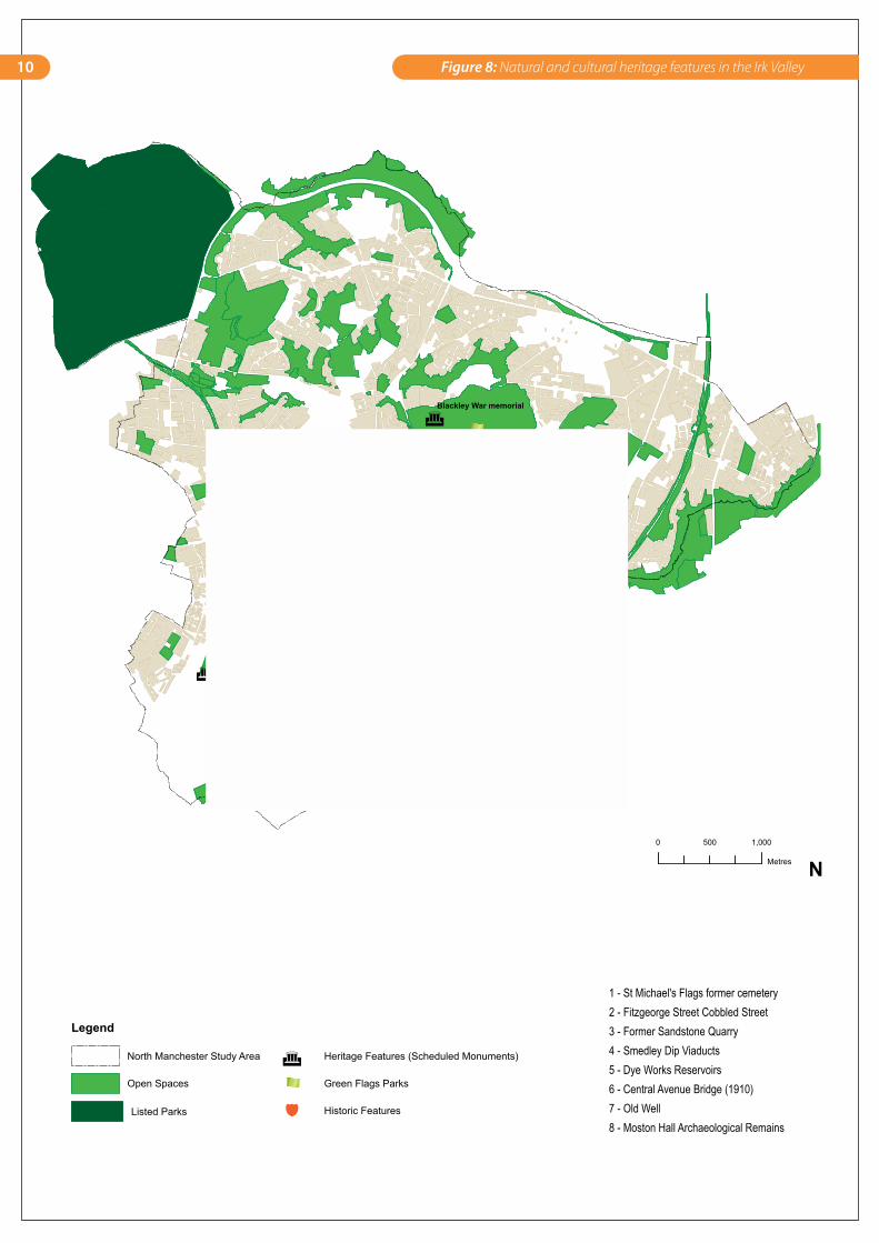
Natural and cultural heritage
North Manchester has some well-developed formal parks and heritage features. The listed Victorian parks of Heaton Park and Queens Park are complemented by the similarly historic areas of Boggart Hole Clough and Cheetham Park; both Boggart Hole Clough and Cheetham Park contain listed monuments. A number of remnant features from the industrial past remain, such as the viaducts at Smedley Dip and the reservoirs at the Harpurhey Reservoirs site. Other historical features include the remains of Moston Hall in Lower Broadhurst Clough (Figure 8).
Boggart Hole Clough, Crumpsall Park and St Michael’s Flags have been regularly awarded Green Flag status. Blackley Forest has also received a Green Apple award for environmental best practice by the Green Organisation.
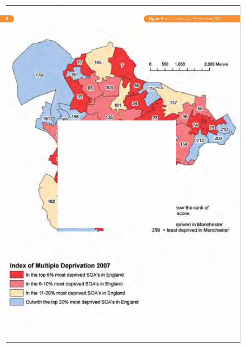
8 Figure 6: Index of Multiple Deprivation 2007
Location of Landfill Sites
Legend
North Manchester Study Area
Open Spaces
Residential Areas
Landfills
0 1,000500
Metres
The locations of the landfill is indicated on the enclosed plan. It must be emphasised that the boundary marked represents thelimit of the site on which landfilling operations were assumed to have taken place, and does not necessarily show the extent of actual infill. It cannot therefore be assumed either that the entire site was filled, or that there was no filling or over-spill beyond themarked boundary. Source: MCC Environmental ServicesN
9Figure 7: Landfill sites
Blackley War memorial
Cheetham Park Bandstand
3
1
2
6
7
5
8
4
Natural and Cultural Heritage Features
Legend
North Manchester Study Area
Open Spaces
Heritage Features (Scheduled Monuments)
Green Flags Parks
Historic Features
0 1,000500
Metres
1 - St Michael's Flags former cemetery2 - Fitzgeorge Street Cobbled Street3 - Former Sandstone Quarry4 - Smedley Dip Viaducts5 - Dye Works Reservoirs6 - Central Avenue Bridge (1910)7 - Old Well8 - Moston Hall Archaeological Remains
Listed Parks
N
10 Figure 8: Natural and cultural heritage features in the Irk Valley
11Introduction
1.2 Purpose of the Irk Valley Local Plan
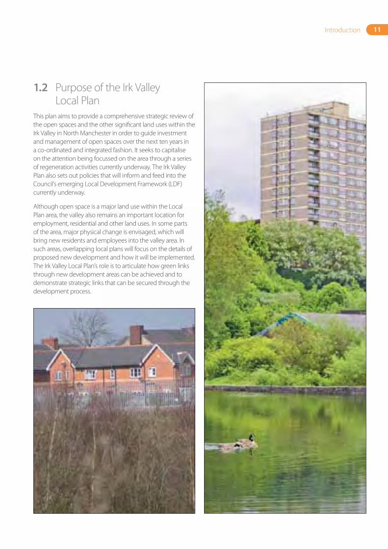
This plan aims to provide a comprehensive strategic review of the open spaces and the other significant land uses within the Irk Valley in North Manchester in order to guide investment and management of open spaces over the next ten years in a co-ordinated and integrated fashion. It seeks to capitalise on the attention being focussed on the area through a series of regeneration activities currently underway. The Irk Valley Plan also sets out policies that will inform and feed into the Council’s emerging Local Development Framework (LDF) currently underway.
Although open space is a major land use within the Local Plan area, the valley also remains an important location for employment, residential and other land uses. In some parts of the area, major physical change is envisaged, which will bring new residents and employees into the valley area. In such areas, overlapping local plans will focus on the details of proposed new development and how it will be implemented. The Irk Valley Local Plan’s role is to articulate how green links through new development areas can be achieved and to demonstrate strategic links that can be secured through the development process.

2. Strategic Context
14 Irk Valley Local Plan – North Manchester
2.1 Policy contextThis section provides a summary of all the policies related to the Irk Valley Plan. Key national, regional and local policies are noted below:
National
Three government documents are considered particularly relevant to setting the UK national policy context on open spaces:
• OurTownsandCities:TheFuture–DeliveringanUrbanRenaissance(2000): published by the ODPM. This document sought to address the loss of open space within urban areas and ensure adequate provision for communities. This paper led to the establishment of the Urban Green Space Task Force (UGSTF); to advise the Government on its proposals for improving the quality of urban parks, play areas and green spaces.
• GreenSpaces,BetterPlaces(2002): a report by the UGSTF formed the background to the revised PPG 17, establishing the open space categories to be used as the basis for planning, local assessment of need and audits of existing provision.
• PlanningPolicyGuidance17onOpenSpace,SportandRecreation(PPG17): revised in 2002, PPG 17 clearly sets out the Government’s objectives in delivering quality open spaces. It recommends undertaking robust assessments to understand existing and future open space, sports and recreational needs of the community. Additionally, it recognises that biodiversity issues are integral to the broader open space agenda.
15Strategic Context
Regional
On a regional level, the Regional Planning Guidance for the North West (RPG 13) outlines four main policy areas addressing open spaces:
• Deliveringanurbanrenaissance– Policy UR4 – Setting targets for the recycling of land
and buildings
– Policy UR10 – Greenery, urban green space and the public realm
– Policy UR12 – Regional park resources
• Activemanagementofenvironmentalresources– Policy ER5 – Biodiversity and nature conservation
– Policy ER6 – Woodlands
– Policy ER7 – Water resources
– Policy ER8 – Development and flood risk
– An accessible region with an integrated transport system
– Policy T8 – National cycle network
• Ensurehighenvironmentalquality– Policy EQ1 – Tackling derelict land and
contamination issues
16 Irk Valley Local Plan – North Manchester
Local
The four main council strategies providing the framework for delivering open space improvements are:
• Unitary Development Plan (UDP) 1995
• Community Plan (2002)
• Cultural Strategy (2003)
• Strategic Regeneration Framework for North Manchester (2004) (SRFNM)
All four firmly establish the need to improve the physical environment in order to deliver a sustainable environment and therefore, sustainable communities.
The SRFNM was adopted in 2004 and provides the broad framework for regeneration and development of North Manchester. The key policies and actions identified as being relevant to open space improvements include:
1. Improve North Manchester’s image through improving the appeal of open spaces as part of the holistic approach to regeneration.
Specificactionsare:
• Broaden the appeal of public open spaces by creating trails, improving open spaces and setting up events that invite greater use.
• Build linked trails along the River Irk and its tributaries; the trails will help to restore the river as a central feature within North Manchester connecting all areas and increasing levels of amenity for local residents.
• Introduce events into the Irk Valley that celebrate its industrial heritage and diverse community strengths.
• Create a network of linked recreational trails.
• Continue to invest in major parks.
• Continue to invest in high-level management of local parks.
• Enhance and restore areas of particular biological and historical significance and interest.
2. Eradicate problems of neglected and derelict land by capitalising on opportunities to form new parks and redevelop under-utilised open spaces.
Specificactionsare:
• Raise the profile of key under-utilised sites.
• Identify sites for early development.
3. Promote partnerships to enable strategic investment and maintenance of open spaces. Limited funds are available to manage and improve parks and open spaces; therefore every effort should be made to form partnerships to increase funds, labour, resources and promote stewardship.
Specificactionsareto:
• Build on momentum and support voluntary agencies.
• Encourage residents’ involvement.
• Engage the private sector.
3. Baseline
18 Irk Valley Local Plan – North Manchester
3.1 Ownership and management of open spaces
3.1.1 GeneralFigures 9 and 10 illustrate the current ownership and management status of open spaces within the Irk Valley, based on information supplied by NMR, the Irk Valley project officer and other internal Council departments. The maps show that most land is Council owned but split between various departments. The real ownership of some sites is not known, with records often ascribing ownership to long defunct committees or departments no longer existing in their earlier form. Consequently, some sites are effectively not owned, managed or maintained at all, even though evidence of corporate Council ownership is clear.
3.1.2 OwnershipThe majority of the Irk Valley open space is in Council ownership; however, this is split between at least six different departments, the largest landholders being:
• Manchester Leisure.
• Manchester Housing/Northwards
• Corporate Property
• Neighbourhood Services
This division of ownership, particularly of sites where a mixed ownership situation arises, has affected the ability to clearly manage, maintain and structure improvements to these areas in a co-ordinated way. The Corporate Property Initiative offers scope for improving this situation but only if a substantial increase in maintenance resources can be achieved.
3.1.3 Current management responsibilitiesTwo broad management functions apply to the Irk Valley:
1. Strategicdevelopmentandmanagement of open spaces – involving the planning and development of open spaces over the longer term, with a constant need to evaluate supply, needs and provision standards.
2. Operationalmanagement– involving the day-to-day functions of green space management through continuous maintenance or responding to imminent public needs.
Currently the strategic management of the Irk Valley open spaces is carried out on an ad-hoc basis and tends to respond to funding opportunities. The Parks for all Seasons strategy stated that introducing management plans that consider zoning of landscape types and associated maintenance regimes should be a priority action for all parks. Having park management plans in place could assist ongoing operational management, co-ordinating functional responsibilities, budgets, funding and revenue, as well as identifying private partner roles for each site. Manchester Leisure’s 2003 Open Space Strategic Management Framework included broad proposals to implement this strategy and plans are now in place for the major parks within the North Manchester management area. At present, very few other green spaces have a specific management plan detailing long-term funding and management.
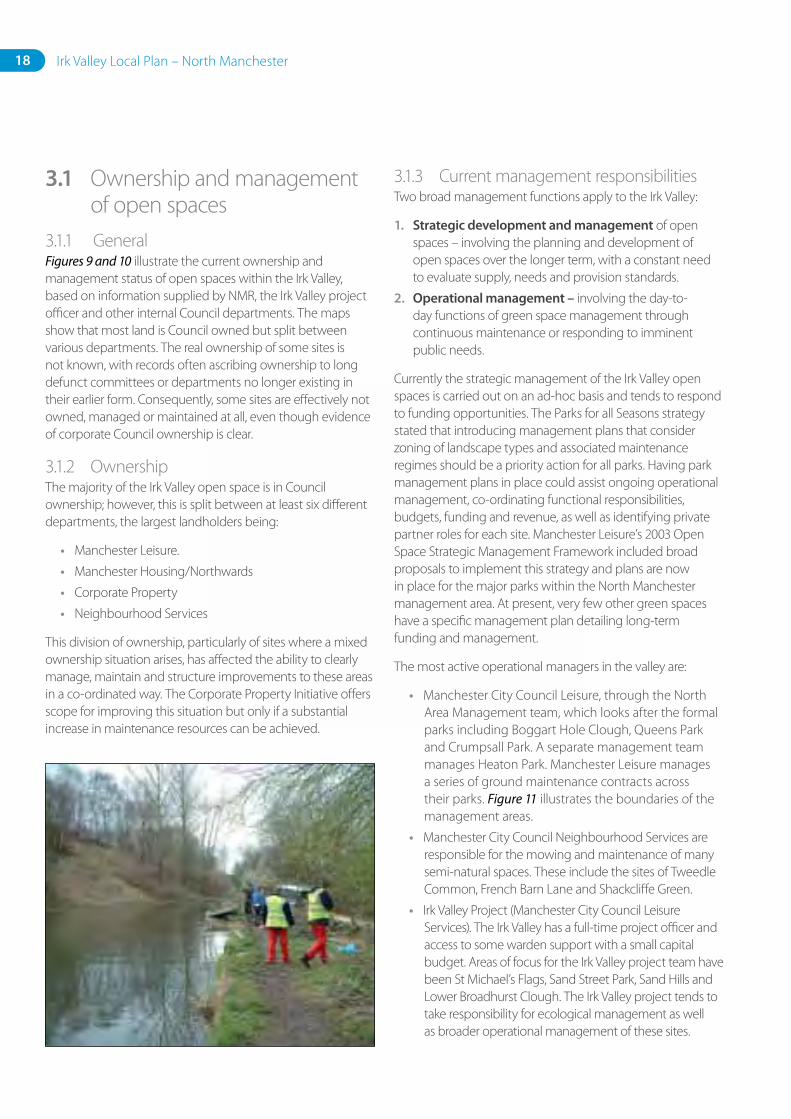
The most active operational managers in the valley are:
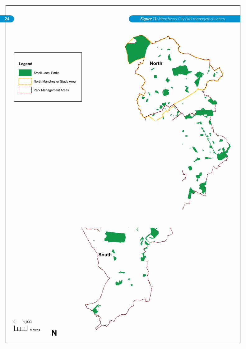
• Manchester City Council Leisure, through the North Area Management team, which looks after the formal parks including Boggart Hole Clough, Queens Park and Crumpsall Park. A separate management team manages Heaton Park. Manchester Leisure manages a series of ground maintenance contracts across their parks. Figure 11 illustrates the boundaries of the management areas.
• Manchester City Council Neighbourhood Services are responsible for the mowing and maintenance of many semi-natural spaces. These include the sites of Tweedle Common, French Barn Lane and Shackcliffe Green.
• Irk Valley Project (Manchester City Council Leisure Services). The Irk Valley has a full-time project officer and access to some warden support with a small capital budget. Areas of focus for the Irk Valley project team have been St Michael’s Flags, Sand Street Park, Sand Hills and Lower Broadhurst Clough. The Irk Valley project tends to take responsibility for ecological management as well as broader operational management of these sites.
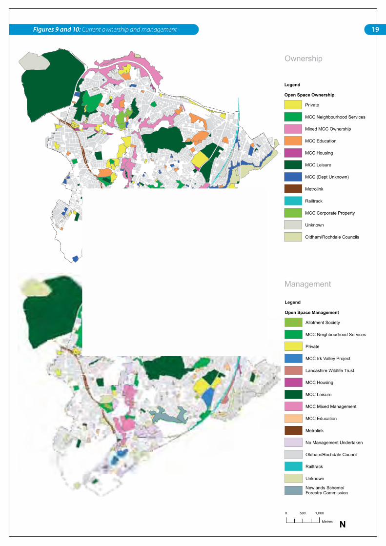
Current Ownership and Management of Open Spaces
Legend
Open Space Ownership
Private
MCC Neighbourhood Services
Mixed MCC Ownership
MCC Education
MCC Housing
MCC Leisure
MCC (Dept Unknown)
Metrolink
Railtrack
MCC Corporate Property
Unknown
Oldham/Rochdale Councils
Residential Areas
0 1,000500
Metres
Legend
Open Space Management
Allotment Society
MCC Neighbourhood Services
Private
MCC Irk Valley Project
Lancashire Wildlife Trust
MCC Housing
MCC Leisure
MCC Mixed Management
MCC Education
Metrolink
No Management Undertaken
Oldham/Rochdale Council
Railtrack
Unknown
Newlands Scheme/Forestry Commission
Ownership
Management
N
19Figures 9 and 10: Current ownership and management
20 Irk Valley Local Plan – North Manchester
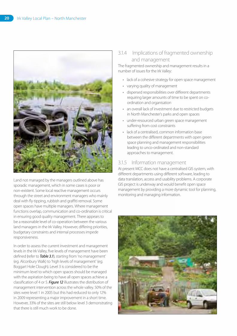
Land not managed by the managers outlined above has sporadic management, which in some cases is poor or non-existent. Some local reactive management occurs through the street and environment managers who mainly deal with fly-tipping, rubbish and graffiti removal. Some open spaces have multiple managers. Where management functions overlap, communication and co-ordination is critical in ensuring good quality management. There appears to be a reasonable level of co-operation between the various land managers in the Irk Valley. However, differing priorities, budgetary constraints and internal processes impede responsiveness.
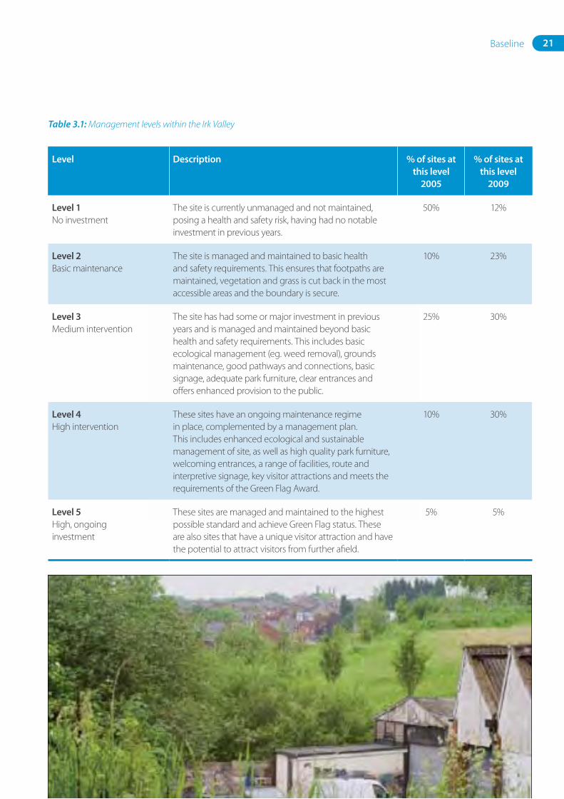
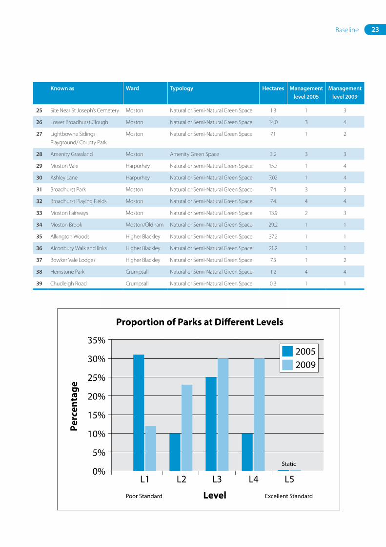
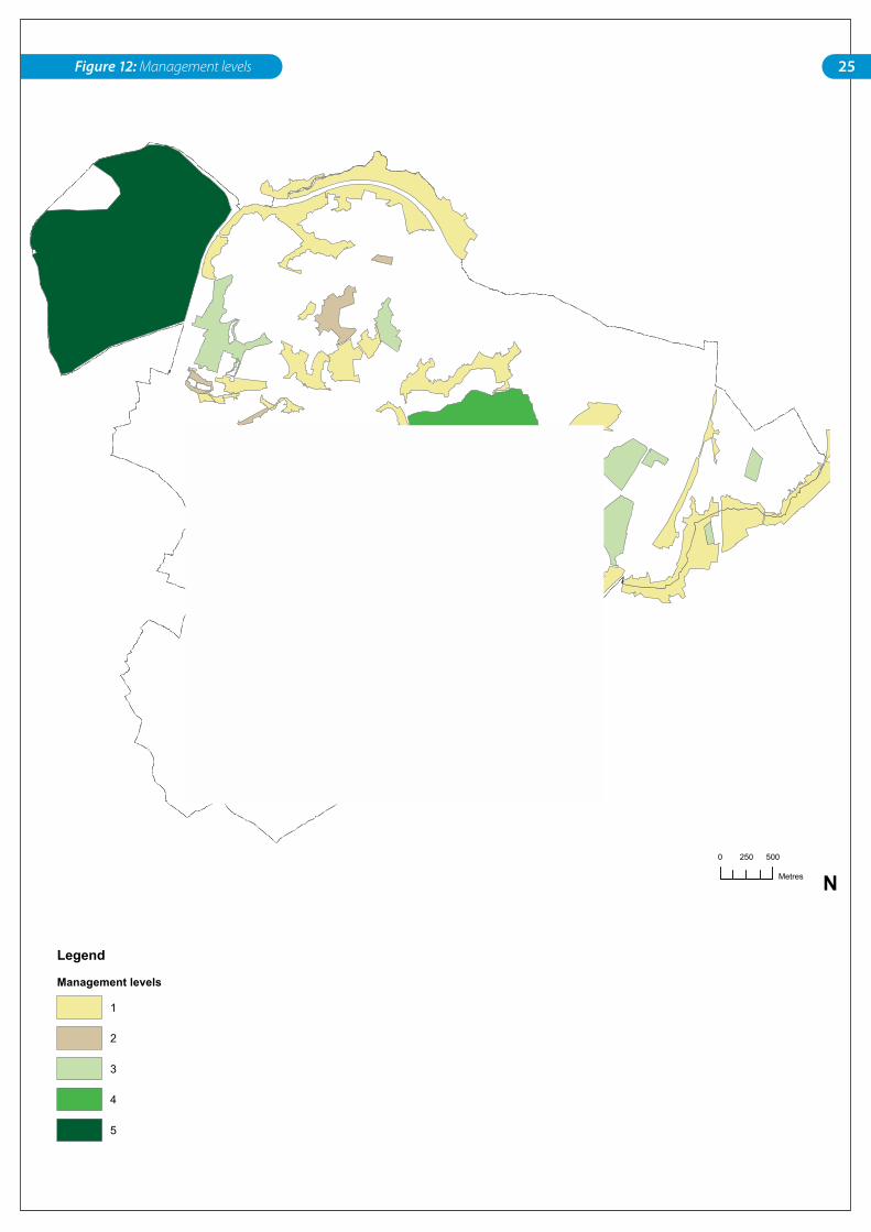
In order to assess the current investment and management levels in the Irk Valley, five levels of management have been defined (refer to Table 3.1), starting from ‘no management’ (eg. Alconbury Walk) to ‘high levels of management’ (eg. Boggart Hole Clough). Level 3 is considered to be the minimum level to which open spaces should be managed with the aspiration being to have all open spaces achieve a classification of 4 or 5. Figure 12 illustrates the distribution of management intervention across the whole valley. 50% of the sites were level 1 in 2005 but this had reduced to only 12% in 2009 representing a major improvement in a short time. However, 33% of the sites are still below level 3 demonstrating that there is still much work to be done.
3.1.4 Implications of fragmented ownership and management
The fragmented ownership and management results in a number of issues for the Irk Valley:
• lack of a cohesive strategy for open space management
• varying quality of management
• dispersed responsibilities over different departments requiring larger amounts of time to be spent on co-ordination and organisation
• an overall lack of investment due to restricted budgets in North Manchester’s parks and open spaces
• under-resourced urban green space management suffering from cost constraints
• lack of a centralised, common information base between the different departments with open green space planning and management responsibilities leading to unco-ordinated and non-standard approaches to management.
3.1.5 Information managementAt present MCC does not have a centralised GIS system, with different departments using different software, leading to data translation, access and usability problems. A corporate GIS project is underway and would benefit open space management by providing a more dynamic tool for planning, monitoring and managing information.
21Baseline
Table 3.1: Management levels within the Irk Valley
Level Description %ofsitesatthislevel
2005
%ofsitesatthislevel
2009
Level1No investment
The site is currently unmanaged and not maintained, posing a health and safety risk, having had no notable investment in previous years.
50% 12%
Level2Basic maintenance
The site is managed and maintained to basic health and safety requirements. This ensures that footpaths are maintained, vegetation and grass is cut back in the most accessible areas and the boundary is secure.
10% 23%
Level3Medium intervention
The site has had some or major investment in previous years and is managed and maintained beyond basic health and safety requirements. This includes basic ecological management (eg. weed removal), grounds maintenance, good pathways and connections, basic signage, adequate park furniture, clear entrances and offers enhanced provision to the public.
25% 30%
Level4High intervention
These sites have an ongoing maintenance regime in place, complemented by a management plan. This includes enhanced ecological and sustainable management of site, as well as high quality park furniture, welcoming entrances, a range of facilities, route and interpretive signage, key visitor attractions and meets the requirements of the Green Flag Award.
10% 30%
Level5High, ongoing investment
These sites are managed and maintained to the highest possible standard and achieve Green Flag status. These are also sites that have a unique visitor attraction and have the potential to attract visitors from further afield.
5% 5%
22 Irk Valley Local Plan – North Manchester
Improvementsinsitemanagementlevels2005–2009
Below is a graphical representation of the improvements achieved in site management levels over the previous four-year period. The aim of the Irk Valley Local Plan is to ensure mechanisms are put in place that will see the sites’ management increased and maintained. The reduction of sites at management Level 1 status by 39 per cent indicated that 39 per cent have increased in standard to Level 2 or 3, therefore improving the overall environmental quality of North Manchester’s green space.
This is a major achievement with the majority of sites now classified as having some significant level of management and maintenance. The aim of the Local Plan is to see this improvement enhanced, consolidated and sustained across all sites in the medium and long term, with the ultimate aim of all sites being classified as Level 4 or 5.
Table 3.2: Site specific management levels within the Irk Valley
Knownas Ward Typology Hectares Managementlevel2005
Managementlevel2009
1 St Michael’s Flags Ancoats and
Clayton
Parks and Public Gardens 1.4 3 4
2 St Catherine’s Cheetham Natural or Semi-Natural Green Space 1.2 2 3
3 Sand Street Park Cheetham Natural or Semi-Natural Green Space 3.5 3 3
4 Sandhills Park Cheetham Natural or Semi-Natural Green Space 5.6 3 3
5 Hendham Vale 2/ Smedley Dip Cheetham Natural or Semi-Natural Green Space 3.9 3 4
6 Hendham Vale 1/ Smedley Dip Cheetham Natural or Semi-Natural Green Space 6.5 2 4
7 Smeaton Play Area Cheetham Parks and Public Gardens 0.5 4 4
8 Queens Park Cheetham Parks and Public Gardens 14.2 3 3
9 Harpurhey Ponds Phase 2 Harpurhey Natural or Semi-Natural Green Space 6.3 2 4
10 Harpurhey Reservoirs Phase 1 Harpurhey Natural or Semi-Natural Green Space 7.2 1 1
11 Crumpsall Recreation Ground Crumpsall Natural or Semi-Natural Green Space 4.3 3 3
12 Factory Lane Slopes Harpurhey Natural or Semi-Natural Green Space 3.0 1 2
13 Remnants of Blackley Forest Higher Blackley Natural or Semi-Natural Green Space 4.7 1 3
14 Blackley Forest Higher Blackley Natural or Semi-Natural Green Space 21.8 3 4
15 Heaton Park Higher Blackley Parks and Public Gardens 248.3 5 5
16 Nutbank Common Higher Blackley Natural or Semi-Natural Green Space 16.1 1 3
17 Sherwell/Sandy Hill Higher Blackley Natural or Semi-Natural Green Space 9.8 1 2
18 Tweedle Common/Park Higher Blackley Natural or Semi-Natural Green Space 9.9 1 3
19 French Barn Lane site Crumpsall Natural or Semi-Natural Green Space 8.4 1 2
20 North of French Barn Lane site Higher Blackley Natural or Semi-Natural Green Space 3.3 1 2
21 Bailey’s Benmore Woods Charlestown Natural or Semi-Natural Green Space 18.1 1 2
22 Boggart Hole Clough Charlestown Parks and Public Gardens 75.3 4 4
23 Boggart Hole Brook/ Lower
Boggart Hole Clough
Crumpsall Natural or Semi-Natural Green Space 2.5 1 2
24 Shackcliffe Green Charlestown Natural or Semi-Natural Green Space 10.7 1 2
23Baseline
25 Site Near St Joseph’s Cemetery Moston Natural or Semi-Natural Green Space 1.3 1 3
26 Lower Broadhurst Clough Moston Natural or Semi-Natural Green Space 14.0 3 4
27 Lightbowne Sidings
Playground/ County Park
Moston Natural or Semi-Natural Green Space 7.1 1 2
28 Amenity Grassland Moston Amenity Green Space 3.2 3 3
29 Moston Vale Harpurhey Natural or Semi-Natural Green Space 15.7 1 4
30 Ashley Lane Harpurhey Natural or Semi-Natural Green Space 7.02 1 4
31 Broadhurst Park Moston Natural or Semi-Natural Green Space 7.4 3 3
32 Broadhurst Playing Fields Moston Natural or Semi-Natural Green Space 7.4 4 4
33 Moston Fairways Moston Natural or Semi-Natural Green Space 13.9 2 3
34 Moston Brook Moston/Oldham Natural or Semi-Natural Green Space 29.2 1 1
35 Alkington Woods Higher Blackley Natural or Semi-Natural Green Space 37.2 1 1
36 Alconbury Walk and links Higher Blackley Natural or Semi-Natural Green Space 21.2 1 1
37 Bowker Vale Lodges Higher Blackley Natural or Semi-Natural Green Space 7.5 1 2
38 Herristone Park Crumpsall Natural or Semi-Natural Green Space 1.2 4 4
39 Chudleigh Road Crumpsall Natural or Semi-Natural Green Space 0.3 1 1
Knownas Ward Typology Hectares Managementlevel2005
Managementlevel2009
0%
5%
10%
15%
20%
25%
30%
35%
Level
Proportion of Parks at Di�erent Levels
Perc
enta
ge
Poor Standard Excellent Standard
Static
L1 L2 L3 L4 L5
20052009
South
East
North
Central
Park Management Areas
Legend
Small Local Parks
North Manchester Study Area
Park Management Areas
0 1,000
Metres N
South
East
North
Central
Park Management Areas
Legend
Small Local Parks
North Manchester Study Area
Park Management Areas
0 1,000
Metres N24 Figure 11: Manchester City Park management areas
Management Levels
Legend
Management levels
1
2
3
4
5
0 500250
Metres N
25Figure 12: Management levels
26 Irk Valley Local Plan – North Manchester
3.1.6 Current budgets, revenue and resources for green space investment
It is difficult to be definitive about the current level of investment in the Irk Valley due to the lack of detailed information at hand; the following commentary is based on information currently known.
MCCLeisurebudget
Manchester Leisure’s budget for 2004/05 was £18.1m, of which 42 per cent (£7.6m) was allocated to outdoor leisure across the entire city. Of the £7.2m available for parks, £1.8m was allocated to Heaton Park and a further £250k was provided to the Mersey Valley Project (342ha in Manchester and Trafford). The remaining £5.25m was distributed to park management in the other three park districts. North Area Parks currently manages 290 hectares of open space. The level of funding is low given the size of the area required to be maintained.
MCCLeisureincomefromgreenspaceassets
Manchester Leisure has some income-generating assets that could potentially be used to fund the vision. However, the 2002 Best Value (BV) review recognised that rental income is not enough to maintain current revenue expenditure. It further recommended a full review to be undertaken to look at the possibility of transferring this landlord function to the housing department. BV also proposed a single landlord status for park buildings as a way of managing the income from revenue-generating assets such as:
1. banqueting and conference catering halls, such as Heaton Hall Orangery; Queens Park restoration centre
2. catering outlets in parks, such as the café in Boggart Hole Clough
3. pitch letting
4. fairs and events
5. plant sales from horticultural centres
6. buildings in parks, including domestic housing, galleries, catering, early years and play/beehive buildings, depots, toilets and visitor centres.
Possibilities exist to improve these facilities to increase the revenue income; for example, improvements to the café at Boggart Hole Clough, the hall within Queens Park or the pavilion facilities at Broadhurst Park. However, this will require initial capital investment.
IrkValleyProjectbudget
Manchester Council provided £75,571 for the Irk Valley Project in 2009/10, broken down as follows:
• £18,000 for capital investment
• £27,400 for the Irk Valley project officer (IVPO)
• £30,171 for part-time grounds maintenance staff and vehicle hire.
This was match-funded by £22k of in-kind support by Groundwork. These funds are currently only directed at the MCC Irk Valley Project sites, which are shown on figure 10. Based on these values, approximately £1,569.70 revenue cost was allocated per hectare.
27Baseline
OthersourcesoffundingforIrkValleysites
In addition to the core funding by Manchester City Council, the Irk Valley Project has secured further funding to the value of £5.53m. It is clear from this that spending has increased. This has generally been focused on very few sites, primarily Moston Vale, St Michael’s Flags and Blackley Forest.
Leverage of the Irk Valley Project to attract external funding provides a good return on the Council’s investment; however, it has a number of disadvantages:
• A large amount of Irk Valley officer time is spent researching and writing funding bids.
• Funding is often for capital investment only. Without revenue for ongoing maintenance the initial investment degrades over time.
• The need to respond to the objectives of external funding source criteria tends to prioritise the order of investment, rather than an overriding strategy.
Overall Site Quality Score and Management Responsibilities
Legend
Management responsibilities
Various
MCC Green Spaces
MCC Housing
MCC Leisure
Manchester Contracts
Irk Valley
None or Unknown
Overall score
Very Poor
Poor
Adequate
Good
0 1,000500
Metres
N
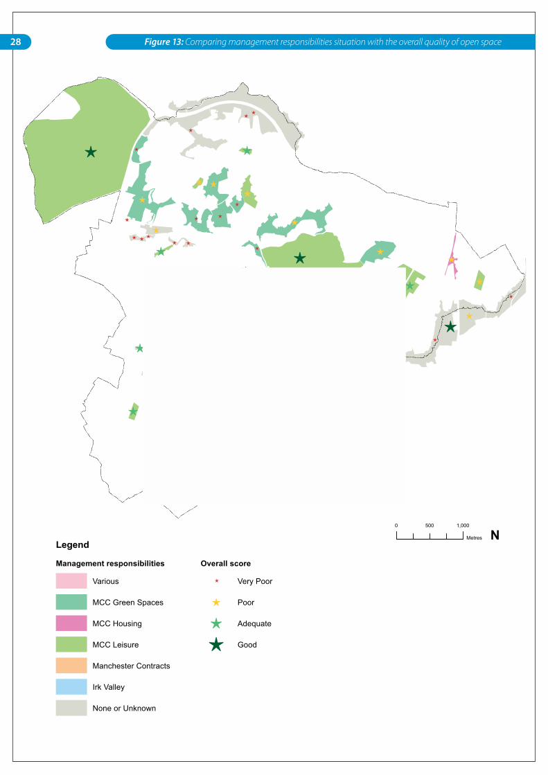
28 Figure 13: Comparing management responsibilities situation with the overall quality of open space
29Baseline
3.2 Local action and community involvement
Previous studies have led to a range of initiatives relating to open spaces in the Irk Valley, including the establishment of the Irk Valley Project. Recent initiatives and studies are described below:
TheIrkValleySteeringGroup
The Irk Valley Project is a partnership between Manchester City Council, residents’ groups voluntary organisations and other public agencies. These are listed in Table 3.3 on page 31. The partnership meets quarterly as the Irk Valley Steering Group and agrees the way forward for the Irk Valley sites. The operational management of the sites is undertaken by the Irk Valley project officer along with a part-time grounds maintenance officer.
Parkwardens
Park wardens operate in Boggart Hole Clough, Queens Park, Crumpsall Park and Heaton Park, and are responsible for arranging community events and promoting park use. The Best Value review (2001) raised the need to have one warden per ward, linking local communities to local parks.
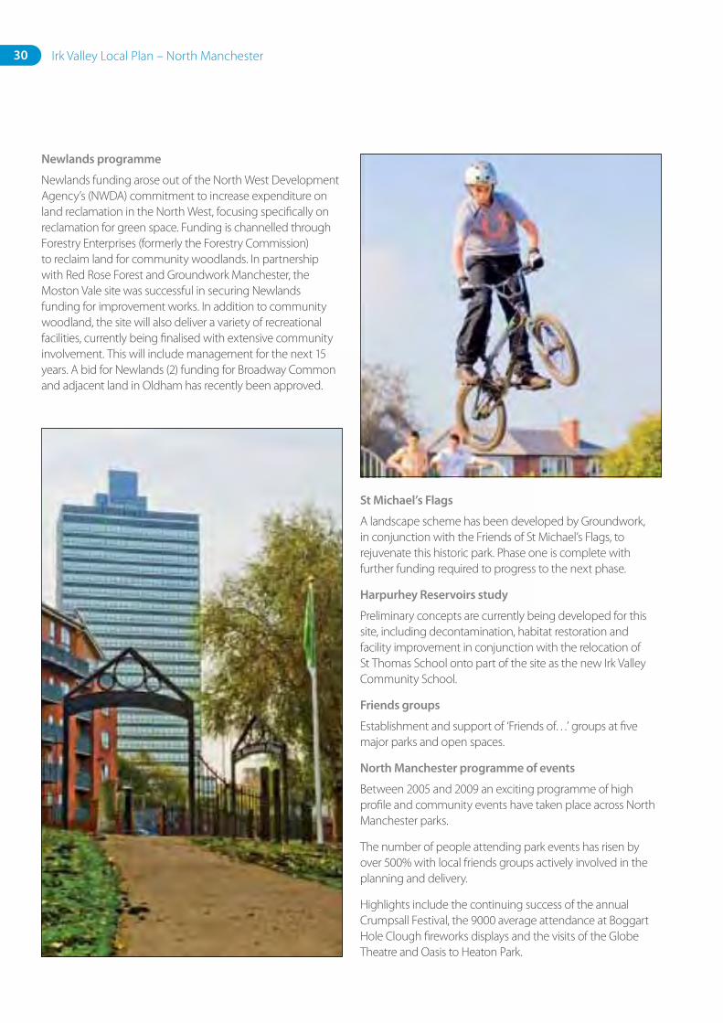
IDigMostonproject
The I Dig Moston project aimed to focus the attentions of local people on their heritage and Lower Broadhurst Clough. It ran from 2003–2006, planned by experts from Manchester University, with nearly 300 hundred children from six local schools visiting the site based around an archaeological dig of the former Moston Hall.
BlackleyForest
Groundwork, MCC and Red Rose Forest in conjunction with the Friends of Blackley Forest have been undertaking infrastructure (paths, signage and boundary fencing) and ecological improvements, which were instrumental in achieving Local Nature Reserve status.
Millenniumprojects
In the year 2000, under the Millennium Lottery Funding, Groundwork Manchester upgraded a number of sites along the Irk Valley.
• St Catherine’s Park
• Sand Street
• Sandhills
• Smedley Dip
• Smeaton Play Area
30 Irk Valley Local Plan – North Manchester
Newlandsprogramme
Newlands funding arose out of the North West Development Agency’s (NWDA) commitment to increase expenditure on land reclamation in the North West, focusing specifically on reclamation for green space. Funding is channelled through Forestry Enterprises (formerly the Forestry Commission) to reclaim land for community woodlands. In partnership with Red Rose Forest and Groundwork Manchester, the Moston Vale site was successful in securing Newlands funding for improvement works. In addition to community woodland, the site will also deliver a variety of recreational facilities, currently being finalised with extensive community involvement. This will include management for the next 15 years. A bid for Newlands (2) funding for Broadway Common and adjacent land in Oldham has recently been approved.
StMichael’sFlags
A landscape scheme has been developed by Groundwork, in conjunction with the Friends of St Michael’s Flags, to rejuvenate this historic park. Phase one is complete with further funding required to progress to the next phase.
HarpurheyReservoirsstudy
Preliminary concepts are currently being developed for this site, including decontamination, habitat restoration and facility improvement in conjunction with the relocation of St Thomas School onto part of the site as the new Irk Valley Community School.
Friendsgroups
Establishment and support of ‘Friends of…’ groups at five major parks and open spaces.
NorthManchesterprogrammeofevents
Between 2005 and 2009 an exciting programme of high profile and community events have taken place across North Manchester parks.
The number of people attending park events has risen by over 500% with local friends groups actively involved in the planning and delivery.
Highlights include the continuing success of the annual Crumpsall Festival, the 9000 average attendance at Boggart Hole Clough fireworks displays and the visits of the Globe Theatre and Oasis to Heaton Park.
31Baseline
Table 3.3: Active stakeholders in the Irk Valley
Group Nameofpartner RoleinIrkValley
Parks’ Friends groups • Friends of Blackley Forest Involved with management and events
• Friends of Queens Park
• Friends of St Michael’s Flags and Angel Meadows
• Friends of Broadhurst Clough and Park
• Friends of Boggart Hole Clough
• Friends of Crumpsall Park
• Boggart Hole Clough Community Action Trust
Residents/tenants associations (examples)
• Crosslee Tenants Association
• Planthill TARA
• Moston Valley Residents Association
Involved in future planning for local open spaces
Adjacent Local Authorities
• Oldham MBC
• Rochdale MBC
Partners for cross boundary initiatives
Statutory agencies • Red Rose Forest A local delivery agent for the Forestry Commission; an environmental initiative dedicated to protecting, increasing and promoting Greater Manchester’s woodlands and green spaces
• Environment Agency Water quality of the river system
Potential involvement with the contaminated site at Harpurhey Reservoirs
• NWDA Through the Newlands funding initiative, will deliver the reclamation of Moston Vale and Broadway Common to a District Level Park facility.
• Forestry Commission As above
Environmental organisations
• BTCV Occasional involvement
• Groundwork Environmental expertise and involvement in delivery of plan throughout the valley
Working on Moston Vale development proposals
• Lancashire Wildlife Trust Manage the Moston Railway Sidings SBI site
Private corporations/businesses/organisations
• King William Fishing Club Manage the reservoir sites for private fishing
• HMG Paints Invested in open space around their site and at Smedley Dip
32 Irk Valley Local Plan – North Manchester
3.3 Baseline conclusionsThe North Manchester open space network is a key asset and much has been achieved in recent years to improve parts of it.
The study has shown a significant deficiency still remains in the quality of open space provision currently offered to the local community in North Manchester. While open spaces with actual or potential recreational value make up almost 27 per cent of the land area in North Manchester, many do not make full use of their recreational, ecological and amenity potential.
Furthermore, despite the seemingly wide geographic coverage of natural green space, some of the residential areas are not within easy reach due to physical access barriers. Some sites suffer from poor quality provision, with no infrastructure facilities, unwelcoming entrances and undefined or inaccessible boundary edges. As a result, they remain largely unwelcoming and under-used public space.
In addition, there are not enough play facilities with 81.2 per cent of residential areas not sited within walking distance to a NEAP. Almost 65 per cent are not within an acceptable distance to any sort of play space. On average, there is one outdoor play space for every 737 children over the whole area.
Creating a connected open green space network to enhance North Manchester as a place to live and work is a feasible concept; real opportunities exist to deliver environmental, social and economic benefits for the local population and beyond. Tangible projects have been identified in the appendix for each action
area. However, major challenges lie ahead and need to be resolved if the concept is to become reality.
There is no doubt that the profile of all parks and natural green spaces in the area needs to be raised in order to define a new identity for the area. Delivering the overall vision for a connected Irk Valley green space network will require sustained commitment from all council departments and external stakeholder interests. Funding will be a major constraint and will need to come from various sources. The fragmented ownership and current management structure is also a fundamental barrier to delivery. There is also a clear need for The Council to formulate a play area policy due to the severe local shortage, investigating in more detail why play areas have not succeeded. Furthermore, consideration of more integrated approaches to planning is necessary by linking and co-ordinating management responsibilities. A corporate GIS will assist in moving towards this end. There is also a clear need for a management strategy to deal with the diverse nature of green space types in North Manchester, integrating and unifying management regimes under a single organisation or managing body who will co-ordinate management responsibilities. In summary, the key challenges are:
• consolidating the fragmented ownership situation and reorganising the management structure and key responsibilities
• capital and revenue implications and funding availability
• sustaining commitment by all partners and council departments at all levels and engaging the community
• addressing the issues of antisocial behaviour and vandalism.
4. Vision, principles, objectives and
strategic actions
34 Irk Valley Local Plan – North Manchester
This section provides the broad vision and conceptual framework addressing the critical issues affecting the future of the Irk Valley. Eight key objectives form the basis of the guiding principles for delivering high quality open space provision that come together to create a regional-scale park. These are:
• UsetheIrkValleytoactasacatalystforregeneration
• Providehighquality,safeandaccessibleopenspacesandfacilities
• Improveconnectivityandlinkages
• Improveimageandidentity
• Protectandenhanceecologicalassets
• Resolvemanagementandownershipissues
• Increasecommunityinvolvementandstewardship
• Integrateopenspacewithexistingandproposedbuiltdevelopmentareas
This section also outlines the broad-scale areas of opportunity where action is required to achieve positive change in the Irk Valley.
4.1 VisionThe Irk Valley will be developed into an integrated regional park system featuring a series of accessible, well connected, high quality open spaces. The open space system will contain a range of natural and structured recreational experiences, improving the quality of life for all residents of North Manchester and enhance the regeneration of the area. The park system will protect and enhance biodiversity in the city and foster an appreciation of nature.
This vision was firmly established in the SRFNM as outlined in Section 2.1. The overall aim is to realise the full potential of all existing sites, focusing on quality rather than quantity. Areas of deficiency will be addressed by improving access as well as
enhancing facilities in order to bring them into active use, so that people will want to visit.
In order to achieve this vision, various structural components need to be realised. The essential elements forming the conceptual spatial plan for the regional park system will include:
Promotingrecreation:
• Keydestinationparks (both local- and district-level importance sites) with a range of quality recreational facilities including active (sports and play spaces) and passive (nature trails and natural parks) functions.
Promotingconnectivity
• The Irk Valley trail to include a cycle and walking trail traversing the entire length of the Irk Valley and its tributaries, which will be available from all key gateways and main destination park sites, enabling safe use by pedestrian and cyclists from the city centre to Heaton Park and further afield into Rochdale and Oldham.
• Linkages and connections, which will essentially be open spaces that serve to link the park elements as a continuous corridor and riverside walkway, as well as elements like footbridges, safe road crossings and pathways enabling safe and easy access from one site to the other.
35 Vision, principles, objectives and strategic actions
• Public realm improvements to the surrounding main roads which connect the open spaces, providing essential integration back into the community. These should serve as scenic, safe routes arriving at all the key locations of the regional park network, but are specifically aimed at encouraging local communities to connect with and make use of their local part of the network.
• Gateways, which will act as access nodes into the open space system. These can include public art, parking, signage and information, as well as park furniture.
Promotingaqualityenvironment
• Ecology and landscape quality and diversity. The overall regional park network should be designed to reflect and protect the valley’s diverse range of ecological habitats, as well as the scenic built heritage, natural and water landscape character.
Achieving the vision could set the way for providing an exemplary achievement in sustainable development, design and management. The benefits must be universally acknowledged, embraced and promoted.
Theseinclude:
• Economicbenefits: tourism, flood abatement, employment, attractive setting for new residential development.
• Social: city pride and heritage visual improvements, recreation facilities, reduction in crime, health promotion and learning.
• Environmental: quality in environment, particularly enhancement in biodiversity and improvement in water quality, decontamination and therefore reduced risk to human health.
• Transport: sustainable transport through increased walking and cycling trips.
4.2 Principles, objectives and actions
The following principles and objectives form the basis of the Irk Valley Local Plan:
4.2.1 Using the Irk Valley as a catalyst for regeneration
The Irk Valley has a major role to play in promoting the regeneration of North Manchester through changing the perception of the area and improving the aspirations and quality of life for residents. All relevant Council departments have a role to play, together with other public, private and community partners in delivering the Local Plan and achieving a better quality environment.
Objective:That the Council and its partners and stakeholders in and around the valley recognise the contribution that good quality open spaces make to the quality of life of the local residents, support the development of the proposed new regional park network and work together to maximise input from external partners.
Strategicactions:
• Integrate the Irk Valley Local Plan with other Council strategies and regeneration processes, to support the delivery of the Irk Valley vision. Strategies of particular relevance are the biodiversity strategy, community strategy, environmental/contaminated land strategies, local development framework, waterways strategy and other park management plans.
• Ensure that the principles set out in this section and policy recommendations (outlined in Section 5) are incorporated into the new planning policy framework (local development plans), together with maps showing all significant sites along with their designations.
• Use this document to increase the resources and funding options allocated to open spaces.
36 Irk Valley Local Plan – North Manchester
4.2.2 Provide high quality open space and facilities
Good quality and accessible parks and green spaces with a variety of quality facilities offer greater recreational opportunities and learning experiences for all local residents, as well as promoting healthy living, social inclusion, community development and citizenship. Providing good quality spaces is primarily delivered through good design, but also sustained and protected by good management and maintenance.
Objective: That all open spaces provide a high standard of provision throughout the Irk Valley network to meet the needs of local residents, with the aim of achieving Green Flag status for the entire Irk Valley Regional Park.
Strategicactions:
• Continually enhance existing open spaces, playground and sports facilities in areas of poor quality.
• Improve access to a wider range of open space facilities for areas that are not within walking distance of an existing local park, either through enhancement of existing provision or creation of new facilities.
• Develop a management plan for all parks and open spaces and consider them as one regional park element.
• Carry out a detailed audit of park facilities and record on a GIS as a baseline.
• Secure additional public open space links on proposed built development sites, particularly in the sections of the valley where strategic links are currently missing.
4.2.3 Improve access to open spaces and linkages
Providing strong linkages and safe, easily accessed routes to open spaces will promote their usage and negate perceptions of abandonment and concerns about crime and antisocial behaviour. Although creating a fully linked open space network through North Manchester is a key aim, it is even more important to ensure that each link is well connected to adjacent residential areas and perceived as a safe, attractive asset by local residents.
Objective:Provide open spaces that are easily accessed and navigated through with strong linkages between residential areas and open space.
Strategicactions:
• Develop interventions for sites that are severed by major roads, waterways or railway lines to create better connectivity.
• Apply ‘Access for all’ standards to all new works being developed where topography allows.
• Provide ‘gateway’ improvements at key sites identified on Figure 16 by improving street furniture, providing signage and improving safe access. These could be done in line with public art and landscape projects, reinforcing community involvement.
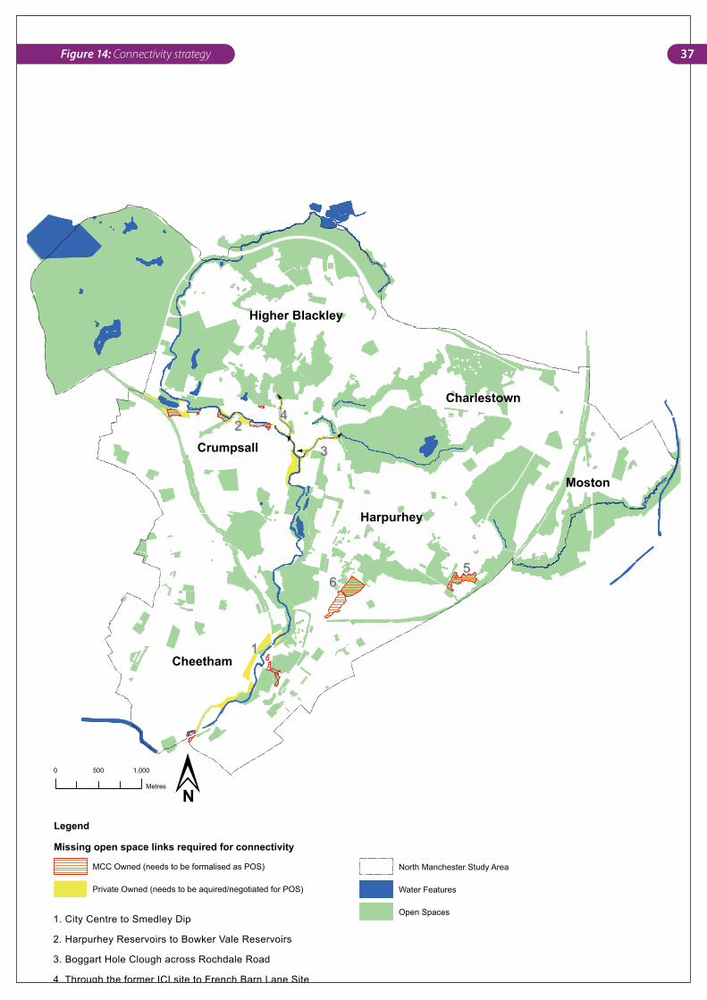
• Secure missing links in the network, as identified on Figure 14 by means specified in the Area Action Plans.
• Make public realm improvements to key road routes (including directional signage along these routes) shown in Figure 15 in order to provide quality environmental continuity.
• Link to Manchester’s cycle and green transport objectives.
• Establish working links with adjoining local authorities to achieve wider connections and accessibility.
11
22
33
44
5566
Cheetham
Higher Blackley
Moston
Harpurhey
Crumpsall
Charlestown
quired for Co
Legend
Missing open space links required for connectivity
MCC Owned (needs to be formalised as POS)
Private Owned (needs to be aquired/negotiated for POS)
North Manchester Study Area
Water Features
Open Spaces
0 1,000500
Metres
1. City Centre to Smedley Dip
2. Harpurhey Reservoirs to Bowker Vale Reservoirs
3. Boggart Hole Clough across Rochdale Road
4. Through the former ICI site to French Barn Lane Site
5. Lightbowne Country Park to Moston Vale
6. Moston Vale to Queens Park across Lathbury Road
�N
37Figure 14: Connectivity strategy
38 Irk Valley Local Plan – North Manchester
4.2.4 Improve image and identityImproving the image and identity of parks and green spaces not only contributes to revitalising community spirit and creating a sense of place, but also creates quality townscapes that are attractive to visitors, as well as promoting regeneration of the area.
Objective: Change people’s perceptions of the Irk Valley to encourage usage of spaces, to discourage inappropriate use and create stewardship by tackling crime and improving the overall environment.
Strategicactions:
• Develop a comprehensive signage and park furniture strategy and guidelines for the Irk Valley, making it easier for people to visit, get around and be informed. Area-wide identity is necessary for promoting the Irk Valley vision.
• Identify and tackle local points of antisocial behaviour.
• Form partnerships with police, neighbourhood watch schemes and youth groups to tackle problems with vandalism.
• Design out crime through well-thought-out design, including:
• removing undergrowth to provide clear sight lines
• lighting of strategic parts of the path system, such as entrances to facilities used after dark
• planting to discourage usage where appropriate (eg. thorny bushes along park perimeters)
• measures to prevent unwanted vehicular access to open spaces.
• All park entrances should be attractive, clear of overgrown vegetation, visible and inviting to encourage usage.
• Secluded entrances down alleyways should be upgraded or removed and accessible entrances created in isolated areas.
4.2.5 Protect and enhance the ecological assets
Many Irk Valley sites are naturalised green space with a variety of ecological habitats; these help increase biodiversity and environmental sustainability as well as providing sustainable urban drainage systems. Biodiversity is an important consideration and this is firmly established in the MCC Biodiversity Strategy. Furthermore, the network provides a valuable educational resource for schools, offering outdoor classroom opportunities.
Objective:To recognise the significance of these sites to promote biodiversity and meet the objectives of the Council’s biodiversity strategy.
Strategicactions:
• Ensure that revisions of the draft biodiversity action plan incorporate the principles of the Irk Valley Local Plan and tie in actions relating to biodiversity.
• Carry out Habitat phase one assessments of all sites with high biodiversity potential and allocate all relevant sites with appropriate designations.
• Subsequently, designate sites identified as important ecological sites for protection as either LNRs, SBIs, green corridors, etc.
• Implement the actions in the waterways strategy to improve the water quality of the River Irk and protect priority habitats and species.
• Prepare a tree and woodland strategy, which could encompass both street trees and park trees. This is especially important to address disease currently affecting the poplars and also improving the streetscape environment along the key routes identified as requiring public realm improvements.
39 Vision, principles, objectives and strategic actions
4.2.6 Consolidating ownershipConsolidation of open space ownership will ensure the efficient and strategic management of all sites.
Objective:Bring all open spaces considered to be part of the Irk Valley Regional Park system under single ownership responsible for the management of the whole network. This includes all spaces within the action areas identified on Figure 17.
Strategicactions:
• Ownership within these areas transferred to a single body together with the current allocated revenue maintenance resources
• In instances where private sector partners are involved (particularly in Areas 1 and 4 on Figure 17), then sites should either be acquired or clear agreements on responsibilities and expectations should be established.
• Consult with key private stakeholders as to the future plans and options for strategic missing link sites.
4.2.7 Consolidating managementTo ensure a coherent identity throughout the Irk Valley, all open spaces will benefit from being managed by a single managing body. Furthermore, consideration of more integrated approaches to planning, designing, managing and maintaining open spaces is necessary; linking these to corporate Council strategies will ensure improved partnership working both within the Council and externally. Ongoing review and monitoring is also necessary in line with on-the-ground changes and achievements.
Objective: Create a single managing body that will have responsibility for capital investment and ongoing management issues of all open spaces in the Irk Valley Regional Park system.
Strategicactions:
• The role of the Irk Valley Steering Group in the short-term and the composition of the partnership in this process need to be clarified and strengthened. Their long-term role will also need to be considered in terms of how they fit into the overall open space management framework.
• Develop a clear management plan for each of the 14 action areas, utilising existing resources and identify all sites which require greater resources to fulfil their potential.
• The Irk Valley Action Plans should be updated annually to reflect priorities and funding availability.
40 Irk Valley Local Plan – North Manchester
• The Irk Valley Strategy should be revised every five years to reflect achievements and changing issues.
• Agreements with any third party land managers (Newlands, private management companies, etc.) need to achieve quality outcomes for residents.
• Use a GIS database as an information resource to inform day-to-day planning decisions and secure section 106 funding options wherever possible for enhancing provision within the identified deficient areas.
4.2.8 Community involvementEncouraging community involvement is crucial to the success of the Irk Valley. It increases a sense of ownership and care for the environment as well as meeting people’s needs and ultimately creating more sustainable communities.
Objective:Encourage community involvement through current and new partnerships and in line with the Council’s Community Plan and Cultural Strategy.
Strategicactions:
• Consult community groups on issues and solutions proposed for the Irk Valley.
• Involve youth in future planning of playground and youth provision
• Work with private landholders and partners to improve the open space not subject to Council Irk Valley management.
• Develop programmes in conjunction with local schools to promote the involvement of children in understanding, monitoring and assisting with the Irk Valley.
• Work with health partners to promote recreation opportunities and benefits.
• Support existing friends and residents groups with an interest in the valley and assist formation of new groups where possible.
• Secure enhanced management and maintenance resources by maximising input from other public bodies, community groups and local businesses.
• Build on the work of current managers, park wardens, events and friends groups.
5. Local Plan-wide Policy
42 Irk Valley Local Plan – North Manchester
5.1 Safeguarding sitesDesignation of publicly accessible open space
• All sites designated as PAOS on the 14 action plans forming the appendix should be designated to protect them from development, which should only be permitted if it is ancillary to a use already taking place on the PAOS or where there is a demonstrable need for the development that cannot reasonably be satisfied elsewhere.
• The allocation of sites with the Irk Valley Local Plan as PAOS will be incorporated into the emerging LDF, thereby securing their long-term future use.
• In cases where sites are privately owned, but where public accessibility has been agreed, then these sites should also be designated as PAOS.
5.2 New or enhanced open space provision
• The Council will require major new developments in or adjacent to areas with public open space deficiency to contribute to open space in the form of local parks, or make a contribution to improving the quality of existing parks through facility enhancement.
• All new developments or redevelopments of existing areas should ensure all possible measures are taken to enhance access to existing public open space.
• The Council will seek to secure funds from Section 106 agreements and other sources to support the provision of new PAOS where possible and improvement of existing open spaces.
• Development that adjoins open space should provide a road frontage along the boundary edge with buildings overlooking the open space.
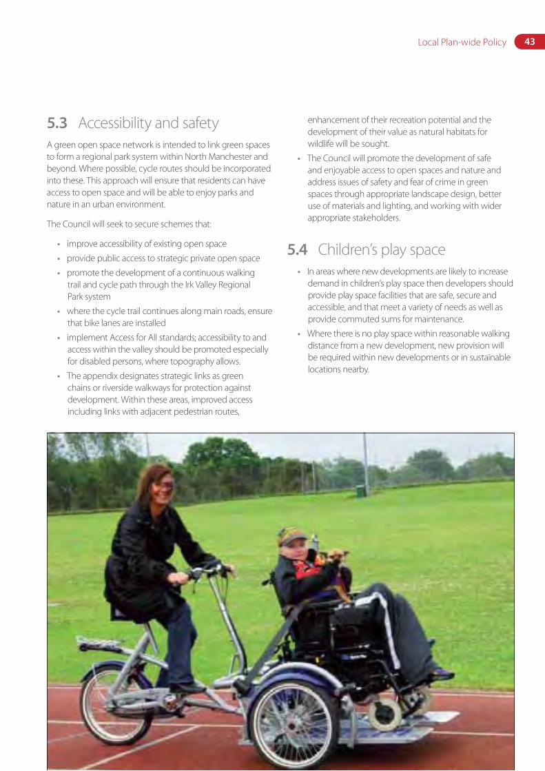
43Local Plan-wide Policy
5.3 Accessibility and safetyA green open space network is intended to link green spaces to form a regional park system within North Manchester and beyond. Where possible, cycle routes should be incorporated into these. This approach will ensure that residents can have access to open space and will be able to enjoy parks and nature in an urban environment.
The Council will seek to secure schemes that:
• improve accessibility of existing open space
• provide public access to strategic private open space
• promote the development of a continuous walking trail and cycle path through the Irk Valley Regional Park system
• where the cycle trail continues along main roads, ensure that bike lanes are installed
• implement Access for All standards; accessibility to and access within the valley should be promoted especially for disabled persons, where topography allows.
• The appendix designates strategic links as green chains or riverside walkways for protection against development. Within these areas, improved access including links with adjacent pedestrian routes,
enhancement of their recreation potential and the development of their value as natural habitats for wildlife will be sought.
• The Council will promote the development of safe and enjoyable access to open spaces and nature and address issues of safety and fear of crime in green spaces through appropriate landscape design, better use of materials and lighting, and working with wider appropriate stakeholders.
5.4 Children’s play space• In areas where new developments are likely to increase
demand in children’s play space then developers should provide play space facilities that are safe, secure and accessible, and that meet a variety of needs as well as provide commuted sums for maintenance.
• Where there is no play space within reasonable walking distance from a new development, new provision will be required within new developments or in sustainable locations nearby.
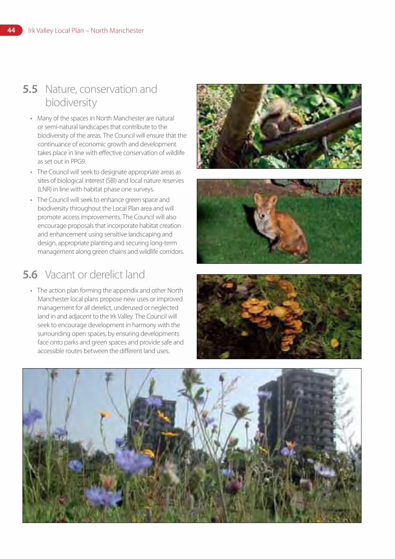
44 Irk Valley Local Plan – North Manchester
5.5 Nature, conservation and biodiversity
• Many of the spaces in North Manchester are natural or semi-natural landscapes that contribute to the biodiversity of the areas. The Council will ensure that the continuance of economic growth and development takes place in line with effective conservation of wildlife as set out in PPG9.
• The Council will seek to designate appropriate areas as sites of biological interest (SBI) and local nature reserves (LNR) in line with habitat phase one surveys.
• The Council will seek to enhance green space and biodiversity throughout the Local Plan area and will promote access improvements. The Council will also encourage proposals that incorporate habitat creation and enhancement using sensitive landscaping and design, appropriate planting and securing long-term management along green chains and wildlife corridors.
5.6 Vacant or derelict land• The action plan forming the appendix and other North
Manchester local plans propose new uses or improved management for all derelict, underused or neglected land in and adjacent to the Irk Valley. The Council will seek to encourage development in harmony with the surrounding open spaces, by ensuring developments face onto parks and green spaces and provide safe and accessible routes between the different land uses.
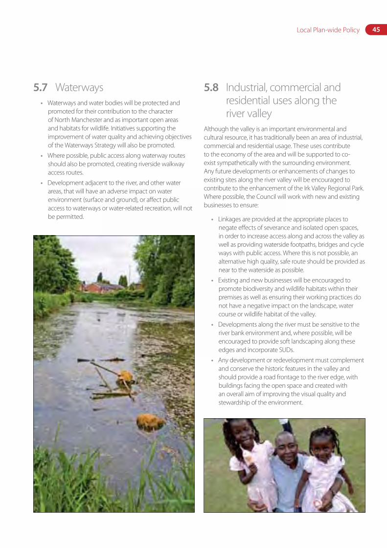
45Local Plan-wide Policy
5.7 Waterways• Waterways and water bodies will be protected and
promoted for their contribution to the character of North Manchester and as important open areas and habitats for wildlife. Initiatives supporting the improvement of water quality and achieving objectives of the Waterways Strategy will also be promoted.
• Where possible, public access along waterway routes should also be promoted, creating riverside walkway access routes.
• Development adjacent to the river, and other water areas, that will have an adverse impact on water environment (surface and ground), or affect public access to waterways or water-related recreation, will not be permitted.
5.8 Industrial, commercial and residential uses along the river valley
Although the valley is an important environmental and cultural resource, it has traditionally been an area of industrial, commercial and residential usage. These uses contribute to the economy of the area and will be supported to co-exist sympathetically with the surrounding environment. Any future developments or enhancements of changes to existing sites along the river valley will be encouraged to contribute to the enhancement of the Irk Valley Regional Park. Where possible, the Council will work with new and existing businesses to ensure:
• Linkages are provided at the appropriate places to negate effects of severance and isolated open spaces, in order to increase access along and across the valley as well as providing waterside footpaths, bridges and cycle ways with public access. Where this is not possible, an alternative high quality, safe route should be provided as near to the waterside as possible.
• Existing and new businesses will be encouraged to promote biodiversity and wildlife habitats within their premises as well as ensuring their working practices do not have a negative impact on the landscape, water course or wildlife habitat of the valley.
• Developments along the river must be sensitive to the river bank environment and, where possible, will be encouraged to provide soft landscaping along these edges and incorporate SUDs.
• Any development or redevelopment must complement and conserve the historic features in the valley and should provide a road frontage to the river edge, with buildings facing the open space and created with an overall aim of improving the visual quality and stewardship of the environment.
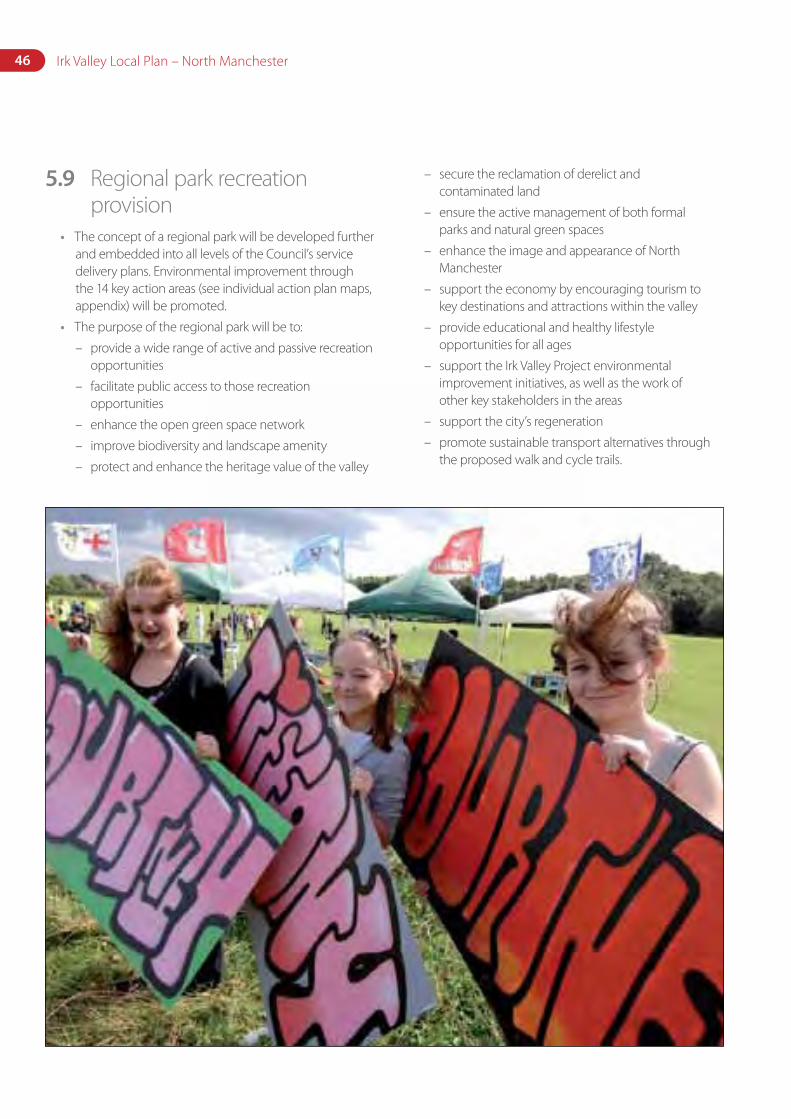
46 Irk Valley Local Plan – North Manchester
5.9 Regional park recreation provision
• The concept of a regional park will be developed further and embedded into all levels of the Council’s service delivery plans. Environmental improvement through the 14 key action areas (see individual action plan maps, appendix) will be promoted.
• The purpose of the regional park will be to:
– provide a wide range of active and passive recreation opportunities
– facilitate public access to those recreation opportunities
– enhance the open green space network
– improve biodiversity and landscape amenity
– protect and enhance the heritage value of the valley
– secure the reclamation of derelict and contaminated land
– ensure the active management of both formal parks and natural green spaces
– enhance the image and appearance of North Manchester
– support the economy by encouraging tourism to key destinations and attractions within the valley
– provide educational and healthy lifestyle opportunities for all ages
– support the Irk Valley Project environmental improvement initiatives, as well as the work of other key stakeholders in the areas
– support the city’s regeneration
– promote sustainable transport alternatives through the proposed walk and cycle trails.
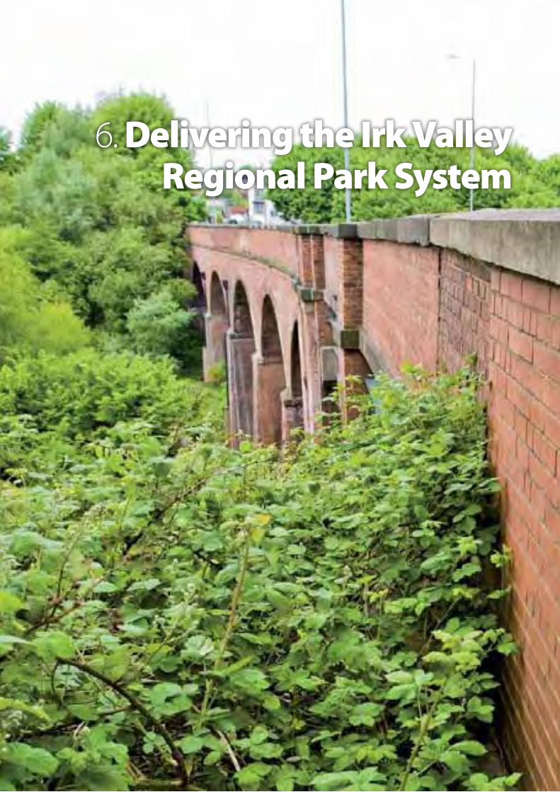
6. Delivering the Irk Valley Regional Park System
48 Irk Valley Local Plan – North Manchester
With the adoption of the SRFNM (2004) there has been a renewed impetus to improve and realise the potential that the Irk Valley raises for regeneration and environmental improvement in the North Manchester area. This Local Plan provides the focus for gaining consensus and driving forward the strategic regeneration objectives set out in the SRFNM and taken forward in more detail in this document.
Achieving the ambitions outlined in the Irk Valley Regional Park requires delivery of actions at two levels:
1. Adoption of the overall principles and conceptual framework, and delivery of strategic actions with regards to policy and management as outlined above.
2. Delivery of the detailed spatial component (which is set out in the appendix and broadly illustrated in Section 6.2) in terms of providing elements that a regional park network should entail – such as linkages and connections, gateways and public realm improvements, quality and variety in recreational facilities, as well as diversity of ecological and landscape settings over the entire Irk Valley open space system.
This section is set out as follows:
• Delivering the regional park spatial plan framework – outlines the overall spatial plan components for delivering the vision for a connected and coherent Irk Valley Regional Park network.
• Delivery mechanisms and responsibilities – highlights existing strategic initiatives, which should be seen as having a role as ‘central delivery mechanisms’ for realising many of the Irk Valley objectives.
• Risk assessment – assesses the key threats and their implications for the success of the vision.
• Performance and monitoring – outlines a methodology for reviewing and evaluating the Irk Valley open space plan to reflect ongoing changes and achievements.
• Implementation – sets out the key strategic management and policy decisions and actions that need to occur, as well as a preliminary assessment of the financial implications for actions identified in Section 6, based on the broad aspirations for each action area.
6.1 Overcoming the main challenges
6.1.1 Ownership, organisational structure and management responsibilities
The fragmented ownership and management situation of open spaces is a crucial constraint to achieving the vision. The only practical way to deal with this situation is to allocate all Irk Valley open space sites to one single centre of responsibility within the Council and to ensure that at least the minimum level of essential management and maintenance funding necessary for acceptable health and safety standards is available from the outset.
Ultimately, the Council aspires to the establishment of a single management structure responsible for the strategic planning and management of all open spaces, irrespective of their type (natural or formal parks), through a clear management plan where projects are driven by this local plan rather than undertaking individual piecemeal interventions as has happened previously. This can be partly achieved through the Corporate Landlord Initiative and forming better working relationships and co-ordinating responsibilities across departments. Further work will be undertaken to assess how best to achieve this aim but it is acknowledged that additional management and maintenance resources will be required whichever management structure exists.
Privately-owned land proposed to form part of the Irk Valley network will be gifted as part of development negotiations in most instances, together with committed sums for ongoing maintenance. In isolated instances, it may need to be acquired by the Council. It is preferable that all the Irk Valley sites are managed together and private management agreements should be avoided, with endowments through section 106 agreements being a preferred option.
There is a range of options for organisational change to deliver a single management structure. Following formal approval of the plan, the Council will undertake a comprehensive review of this matter, together with the funding issues that relate to it, with the aim of identifying and implementing the optimum solution.
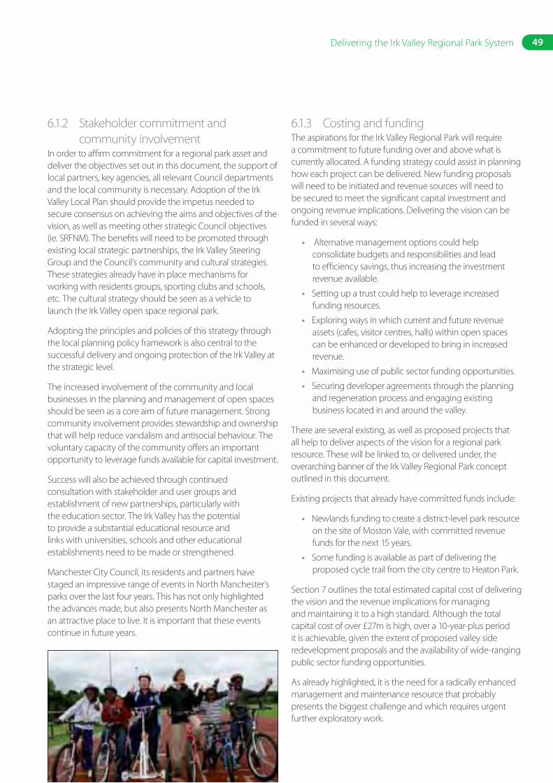
49Delivering the Irk Valley Regional Park System
6.1.2 Stakeholder commitment and community involvement
In order to affirm commitment for a regional park asset and deliver the objectives set out in this document, the support of local partners, key agencies, all relevant Council departments and the local community is necessary. Adoption of the Irk Valley Local Plan should provide the impetus needed to secure consensus on achieving the aims and objectives of the vision, as well as meeting other strategic Council objectives (ie. SRFNM). The benefits will need to be promoted through existing local strategic partnerships, the Irk Valley Steering Group and the Council’s community and cultural strategies. These strategies already have in place mechanisms for working with residents groups, sporting clubs and schools, etc. The cultural strategy should be seen as a vehicle to launch the Irk Valley open space regional park.
Adopting the principles and policies of this strategy through the local planning policy framework is also central to the successful delivery and ongoing protection of the Irk Valley at the strategic level.
The increased involvement of the community and local businesses in the planning and management of open spaces should be seen as a core aim of future management. Strong community involvement provides stewardship and ownership that will help reduce vandalism and antisocial behaviour. The voluntary capacity of the community offers an important opportunity to leverage funds available for capital investment.
Success will also be achieved through continued consultation with stakeholder and user groups and establishment of new partnerships, particularly with the education sector. The Irk Valley has the potential to provide a substantial educational resource and links with universities, schools and other educational establishments need to be made or strengthened.
Manchester City Council, its residents and partners have staged an impressive range of events in North Manchester’s parks over the last four years. This has not only highlighted the advances made, but also presents North Manchester as an attractive place to live. It is important that these events continue in future years.
6.1.3 Costing and fundingThe aspirations for the Irk Valley Regional Park will require a commitment to future funding over and above what is currently allocated. A funding strategy could assist in planning how each project can be delivered. New funding proposals will need to be initiated and revenue sources will need to be secured to meet the significant capital investment and ongoing revenue implications. Delivering the vision can be funded in several ways:
• Alternative management options could help consolidate budgets and responsibilities and lead to efficiency savings, thus increasing the investment revenue available.
• Setting up a trust could help to leverage increased funding resources.
• Exploring ways in which current and future revenue assets (cafes, visitor centres, halls) within open spaces can be enhanced or developed to bring in increased revenue.
• Maximising use of public sector funding opportunities.
• Securing developer agreements through the planning and regeneration process and engaging existing business located in and around the valley.
There are several existing, as well as proposed projects that all help to deliver aspects of the vision for a regional park resource. These will be linked to, or delivered under, the overarching banner of the Irk Valley Regional Park concept outlined in this document.
Existing projects that already have committed funds include:
• Newlands funding to create a district-level park resource on the site of Moston Vale, with committed revenue funds for the next 15 years.
• Some funding is available as part of delivering the proposed cycle trail from the city centre to Heaton Park.
Section 7 outlines the total estimated capital cost of delivering the vision and the revenue implications for managing and maintaining it to a high standard. Although the total capital cost of over £27m is high, over a 10-year-plus period it is achievable, given the extent of proposed valley side redevelopment proposals and the availability of wide-ranging public sector funding opportunities.
As already highlighted, it is the need for a radically enhanced management and maintenance resource that probably presents the biggest challenge and which requires urgent further exploratory work.
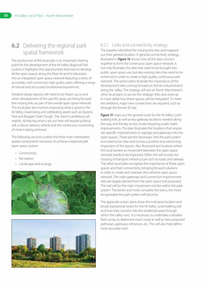
50 Irk Valley Local Plan – North Manchester
6.2 Delivering the regional park spatial framework
The production of this local plan is an important starting point for the development of the Irk Valley Regional Park system; it highlights the opportunities that exist to develop all the open spaces along the River Irk and its tributaries into an integrated open space network featuring a series of accessible, well connected, high quality parks offering a range of natural and structured recreational experiences.
Detailed design layouts will need to be drawn up as and when development of the specific areas can bring forward the missing links as part of the overall open space network. This local plan also involves improving what is good in the Irk Valley, maximising and celebrating assets such as Queens Park and Boggart Hole Clough. The vision is ambitious yet realistic. Achieving what is set out here will require political will, a robust delivery vehicle and the continuous monitoring of what is being achieved.
The following sections outline the three main interrelated spatial components necessary to achieve a regional park open space system:
• Connectivity
• Recreation
• Landscape and ecology
6.2.1 Links and connectivity strategyThe baseline identified the missing link sites and mapped out their general location. A general connectivity strategy, illustrated in Figure 14, shows how all the sites connect together to form the continuous open space network. It not only illustrates the sites that need to be brought into public open space use, but also existing sites that need to be enhanced in order to create a high quality continuous park network. The action plans illustrate the importance of the development sites coming forward on former industrial land along the valley. The strategy will rely on North Manchester’s other local plans to secure the strategic links and work up in more detail how these spaces will be integrated. To meet the ambition, major new connections are required, such as through the former ICI site.
Figure 15 maps out the general route for the Irk Valley cycle/walking trail, as well as key gateway locations needed along the way, and the key access routes requiring public realm improvements. The plan illustrates the locations that require site-specific improvements to signage and gateways into the open spaces. These are the ‘doorways’ into the park system and need to be clear and convey a positive and welcoming impression of the spaces. Also illustrated are locations where the local barriers to movement between the open space network needs to be improved. Often this will involve the crossing of transport infrastructure such as roads and railways. The other local plans recognise the importance of these open spaces and their connectivity, bringing forward solutions in order to create and maintain the cohesive open space network. The main gateways and connection improvement sites are largely derived from the open space trail proposed. The trail will be the main movement corridor within the park system. The better and more complete the trail is, the more recognisable the park system will become.
The appendix action plans show the indicative location and broad aspirational routes for the Irk Valley cycle/walking trail and how they connect into the residential areas through which the valley runs. It is necessary to undertake a detailed field survey to determine exact route as well as new proposed pathways, gateways, entrances, etc. This will also help define more accurate costs.
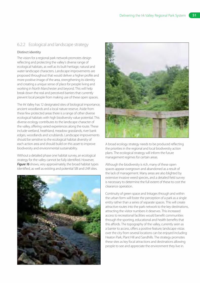
51Delivering the Irk Valley Regional Park System
6.2.2 Ecological and landscape strategy
Distinct identity
The vision for a regional park network promotes design reflecting and protecting the valley’s diverse range of ecological habitats, as well as its built heritage, natural and water landscape characters. Landscape improvements are proposed throughout that would deliver a higher profile and more positive image of the area, strengthening its identity and creating a unique sense of place for people living and working in North Manchester and beyond. This will help break down the real and perceived barriers that currently prevent local people from making use of these open spaces.
The Irk Valley has 12 designated sites of biological importance, ancient woodlands and a local nature reserve. Aside from these few protected areas there is a range of other diverse ecological habitats with high biodiversity value potential. This diverse ecology contributes to the landscape character of the valley, offering varied experiences along the route. These include wetland, heathland, meadow grasslands, river bank edges, woodlands and scrublands. Landscape improvements should be sensitive to the ecological habitat diversity of each action area and should build on this asset to improve biodiversity and environmental sustainability.
Without a detailed phase one habitat survey, an ecological strategy for the valley cannot be fully identified. However, Figure 16 shows, very approximately, the broad habitat types identified, as well as existing and potential SBI and LNR sites.
A broad ecology strategy needs to be produced reflecting the priorities in the regional and local biodiversity action plans. The ecological strategy will inform the future management regimes for certain areas.
Although the biodiversity is rich, many of these open spaces appear overgrown and abandoned as a result of the lack of management. Many areas are also blighted by extensive invasive weed species, and a detailed field survey is necessary to determine the full extent of these to cost the clearance operation.
Continuity of green space and linkages through and within the urban form will foster the perception of a park as a single entity rather than a series of separate spaces. This will create attractive routes into the park network to the key destinations, attracting the visitor numbers it deserves. This increased access to recreational facilities would benefit communities through the sporting, educational and health benefits that this affords. The topography of the valley, currently seen as a barrier to access, offers a positive feature; landscape vistas over the city from several locations can be enjoyed including Heaton Park, Plant Hill and Sandhills. The strategy promotes these sites as key focal attractions and destinations allowing people to see and appreciate the environment they live in.
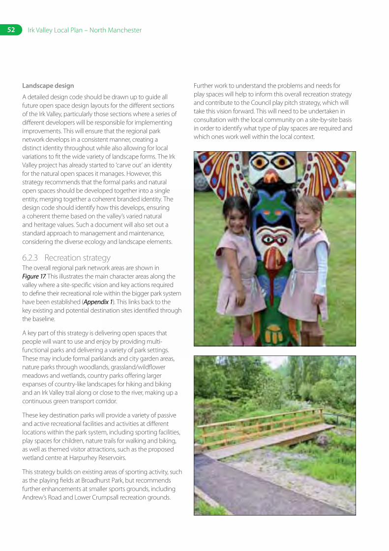
52 Irk Valley Local Plan – North Manchester
Landscape design
A detailed design code should be drawn up to guide all future open space design layouts for the different sections of the Irk Valley, particularly those sections where a series of different developers will be responsible for implementing improvements. This will ensure that the regional park network develops in a consistent manner, creating a distinct identity throughout while also allowing for local variations to fit the wide variety of landscape forms. The Irk Valley project has already started to ‘carve out’ an identity for the natural open spaces it manages. However, this strategy recommends that the formal parks and natural open spaces should be developed together into a single entity, merging together a coherent branded identity. The design code should identify how this develops, ensuring a coherent theme based on the valley’s varied natural and heritage values. Such a document will also set out a standard approach to management and maintenance, considering the diverse ecology and landscape elements.
6.2.3 Recreation strategyThe overall regional park network areas are shown in Figure 17. This illustrates the main character areas along the valley where a site-specific vision and key actions required to define their recreational role within the bigger park system have been established (Appendix 1). This links back to the key existing and potential destination sites identified through the baseline.
A key part of this strategy is delivering open spaces that people will want to use and enjoy by providing multi-functional parks and delivering a variety of park settings. These may include formal parklands and city garden areas, nature parks through woodlands, grassland/wildflower meadows and wetlands, country parks offering larger expanses of country-like landscapes for hiking and biking and an Irk Valley trail along or close to the river, making up a continuous green transport corridor.
These key destination parks will provide a variety of passive and active recreational facilities and activities at different locations within the park system, including sporting facilities, play spaces for children, nature trails for walking and biking, as well as themed visitor attractions, such as the proposed wetland centre at Harpurhey Reservoirs.
This strategy builds on existing areas of sporting activity, such as the playing fields at Broadhurst Park, but recommends further enhancements at smaller sports grounds, including Andrew’s Road and Lower Crumpsall recreation grounds.
Further work to understand the problems and needs for play spaces will help to inform this overall recreation strategy and contribute to the Council play pitch strategy, which will take this vision forward. This will need to be undertaken in consultation with the local community on a site-by-site basis in order to identify what type of play spaces are required and which ones work well within the local context.
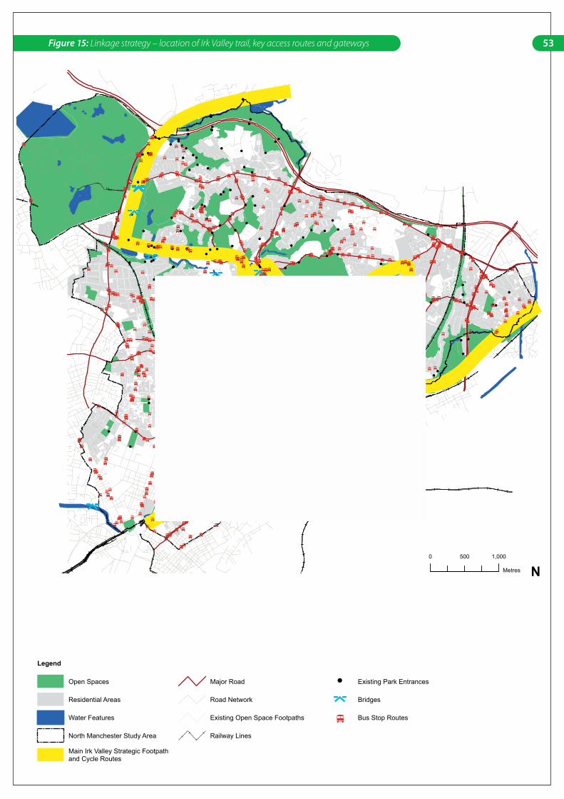
•
•
•
••
••
••
•
•
•
••
• •
••
•
•
••
•
•
•
•
•
•• •
•
•
•
•
•
•••
•• ••
•• ••
•
•
•
•• •
•• •
•
•
•••
••
•
••
• •• •
•
•••
••
•
•••
• ••• •
•••
•
•
•••••
••
•
•
••• •
••
•
•
••
•••••••••
•
••
•
•
••• •
••• •
•• •••
•
•
•
• •••
••
•• ••••
• •
••••
•
•••
•
•
• ••
•• ••
••••
•
• •••• •
•••••
•
•
•
•
•••
•••
•
•
•
Existing Transport and Access Routes
Legend
Open Spaces
Main Irk Valley Strategic Footpathand Cycle Routes
Residential Areas
Water Features
North Manchester Study Area
Major Road
Road Network
Existing Open Space Footpaths
Railway Lines
Existing Park Entrances
Bridges
Bus Stop Routes
0 1,000500
Metres
N
53Figure 15: Linkage strategy – location of Irk Valley trail, key access routes and gateways
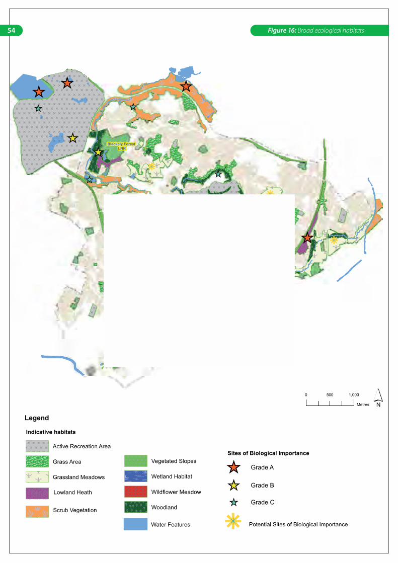
Blackely Forest LNR
Broadhurst Clough
Legend
0 1,000500
Metres
Broad Ecological Habitats
Water Features
Indicative habitats
Active Recreation Area
Grass Area
Grassland Meadows
Lowland Heath
Scrub Vegetation
Vegetated Slopes
Wetland Habitat
Wildflower Meadow
Woodland
Sites of Biological Importance
Grade A
Grade B
Grade C
Potential Sites of Biological Importance
49 PROJECT: Irk Valley Local PlanLAST UPDATED: September 28th, 2005 DRAFT VERSION: 2 FIGURE:
54 Figure 16: Broad ecological habitats
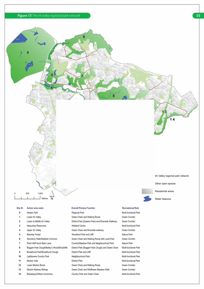
00
88
66
77
99
55
1 41 4
11
44
33
221 11 1 1 01 0
1 31 3
1 21 2
Legend
Irk Valley regional park network
Other open spaces
Residential areas
Water features
0 1,000500
Metres
Site ID Action area name Overall Primary Function Recreational Role
0 Heaton Park Regional Park Multi-functional Park
1 Lower Irk Valley Green Chain and Walking Route Green Corridor
2 Lower to Middle Irk Valley District Park (Queens Park) and Riverside Walkway Green Corridor
3 Harpurhey Reservoirs Wetland Centre Multi-functional Park
4 Upper Irk Valley Green Chain and Riverside walkway Green Corridor
5 Blackley Forest Woodland Park and LNR Nature Park
6 Alconbury Walk/Nutbank Common Green Chain and Walking Route with Local Park Green Corridor
7 Plant Hill/French Barn Lane Country/Meadow Park and Neighbourhood Park Nature Park
8 Boggart Hole Clough/Bailey’s Wood/Shackliffe District Park (Boggart Hole Clough) and Green Chain Multi-functional Park
9 Broadhurst Park/Broadhurst Clough District Park and LNR Multi-functional Park
10 Lightbowne Country Park Neighbourhood Park Multi-functional Park
11 Moston Vale District Park Multi-functional Park
12 Lower Moston Brook Green Chain and Walking Route Green Corridor
13 Moston Railway Sidings Green Chain and Wildflower Meadow Walk Green Corridor
14 Broadway/Oldham Commons Country Park and Green Chain Multi-functional Park
55Figure 17: The Irk Valley regional park network
56 Irk Valley Local Plan – North Manchester
6.3 Delivery mechanisms and responsibilities
There are several Council strategies and schemes already in place that, in part, deliver or have the potential to deliver aspects of the Irk Valley vision. These key delivery mechanisms include:
• Biodiversity action plan
• Waterways strategy
• Cultural strategy
• Community strategy
• Contaminated land strategy
• Local area and park management plans
• Local plans
• SRFNM
• Section 106s/planning and development projects/developer agreements
• Council’s e-government programme (delivery of GIS and information management).
The Irk Valley Local Plan aims to translate the objectives of all these city and district-wide plans into detailed improvement proposals on sites throughout the North Manchester open space network.
Principally, the community strategy and cultural strategy should be seen to act as vehicles for launching the vision for an Irk Valley regional park at the local level.
Delivery responsibilities ultimately lie with the Council, which is responsible for delivering quality open spaces as part of its public service agreement. It is important for the Council to establish a clear and coherent structure at all management levels to be responsible for managing the programme and overseeing the overall project, evaluating milestones and project appraisal.
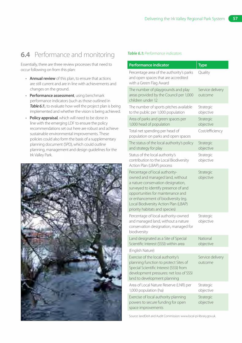
57Delivering the Irk Valley Regional Park System
6.4 Performance and monitoringEssentially, there are three review processes that need to occur following on from this plan:
• Annual review of this plan, to ensure that actions are still current and are in line with achievements and changes on the ground.
• Performance assessment, using benchmark performance indicators (such as those outlined in Table 6.1), to evaluate how well the project plan is being implemented and whether the vision is being achieved.
• Policy appraisal, which will need to be done in line with the emerging LDF to ensure the policy recommendations set out here are robust and achieve sustainable environmental improvements. These policies could also form the basis of a supplementary planning document (SPD), which could outline planning, management and design guidelines for the Irk Valley Park.
Table 6.1: Performance indicators
Performance indicator Type
Percentage area of the authority’s parks and open spaces that are accredited with a Green Flag Award
Quality
The number of playgrounds and play areas provided by the Council per 1,000 children under 12
Service delivery outcome
The number of sports pitches available to the public per 1,000 population
Strategic objective
Area of parks and green spaces per 1,000 head of population
Strategic objective
Total net spending per head of population on parks and open spaces
Cost/efficiency
The status of the local authority’s policy and strategy for play
Strategic objective
Status of the local authority’s contribution to the Local Biodiversity Action Plan (LBAP) process
Strategic objective
Percentage of local authority-owned and managed land, without a nature conservation designation, surveyed to identify presence of and opportunities for maintenance and or enhancement of biodiversity (eg. Local Biodiversity Action Plan (LBAP) priority habitats and species)
Strategic objective
Percentage of local authority-owned and managed land, without a nature conservation designation, managed for biodiversity
Strategic objective
Land designated as a Site of Special Scientific Interest (SSSI) within area
National objective
(English Nature)
Exercise of the local authority’s planning function to protect Sites of Special Scientific Interest (SSSI) from development pressures: net loss of SSSI land to development planning
Service delivery outcome
Area of Local Nature Reserve (LNR) per 1,000 population (ha)
Strategic objective
Exercise of local authority planning powers to secure funding for open space improvements
Strategic objective
Source: IandDeA and Audit Commission: www.local-pi-library.gov.uk.
58 Irk Valley Local Plan – North Manchester
6.5 Implementation planAll of the key strategic actions identified throughout the study are summarised in Table 6.2, together with a broad cost–benefit evaluation. Indicative cost bands are given at this stage, and are summarised in the charts below (Section 6.5.2), which show the relative level of cost by action area and by component type. It should be noted that these cost level estimates are based on the broad aspirations identified by this study for future development of the Irk Valley Regional Park network and provide indicative values only. To refine the cost implications, a complete design development plan will be required for each action area. Detailed designs and costs have already been identified for areas of the Irk Valley previously identified as being priority:
• Harpurhey Reservoirs design options by EDAW 2005
• Moston Vale design plans by Groundwork and partners 2005
• Upper Irk Valley landscape design by City Architects 1999
Detailed designs will be required for many other areas of the park system. Most of these can potentially be delivered through discussions with key developers as part of development proposals. Although this is a favourable option in terms of the cost to the Council, it is necessary that a consistent design approach, standards and the key actions identified here are met. Therefore, it is important that a design code is developed.
6.5.1 General strategic actions summaryThe following are key strategic actions and decisions that need to be reached.
Table 6.2: Generic strategic actions
GENERIC ACTION POINTS C* B* P*
Further field work
Undertake a phase one habitat survey to further establish the baseline and ensure that sites that warrant protection are recognised and designated in the emerging LDF.
2 1 1
Prepare a tree and woodland strategy, which could encompass both street trees and park trees. This is especially important to address disease currently affecting the poplars and also improving the streetscape environment along the key routes identified as requiring public realm improvements.
2 2 2
Carry out a detailed audit of park facilities and record on a GIS as a baseline. 2 2 2
Desktop risk assessment for contaminated land for all sites. 1 1 1
Undertake a detailed field survey to determine extent of invasive weeds and appropriate clean-up methods in order to provide accurate costs for clean-up.
2 3 3
Consultations and user surveys with residents and youth groups to identify local needs for play spaces in local areas.
1 1 1
Further strategic studies and commissions
Review other strategies (including biodiversity strategy, community strategy, environmental/contaminated land strategies, local development framework, waterways strategy, as well as other park management plans, cycle and green transport strategies) to integrate the Irk Valley vision.
1 2 2
Prepare a play space strategy to tackle issues identified in this study. 2 1 1
Develop an overall management plan for the Irk Valley Regional Park network utilising existing resources.
2 3 3
59Delivering the Irk Valley Regional Park System
GENERIC ACTION POINTS C* B* P*
Commission a feasibility study on the costs and legal implications for the management restructuring options outlined in Appendix 2.
1 1 1
Prepare a funding strategy to achieve the bigger capital projects proposed. 2 1 1
Develop a bespoke GIS open space management and planning tool to assist in streamlining open space management.
1 1 1
Developing a comprehensive signage and park furniture strategy and design guidelines for the Irk Valley to form part of a supplementary planning document for open space planning.
2 1 1
Management and policy decisions
Performance indicators should be developed to reflect the key strategic objectives for the city as a whole with the Irk Valley as a major component, not only as part of the Council’s commitment to delivering their corporate service plan objectives but also as a means of monitoring the delivery of this local plan.
1 1 1
Recognise that the current organisational structure will need to be resolved in order to deliver the overall Irk Valley vision; consult with all departments who contribute to open space management or planning, to decide on an agreed way forward on possible management models.
1 3 3
The restructure of the composition of the Irk Valley Steering Group could redefine its focus and how to engage other stakeholders, user groups, local community and statutory agencies in the process.
1 2 2
Form a community charter as a way of agreeing on external involvement and setting targets for each group involved.
1 1 1
Implement a GIS and deploy resources to promote, manage and disseminate the information. 2 1 1
Ensure that the principles and strategic actions set out in Section 4 are considered in all future open space planning and/or incorporated into an overall management plan.
1 3 3
Ensure that the emerging LDF incorporates and protects all the sites identified as part of the regional park system.
1 2 2
Ensure all policy recommendations (outlined in Section 5) are incorporated into the new planning policy framework (local development framework).
1 2 2
C = Cost B = Benefit P = Priority
3 = high 2 = medium 1 = low
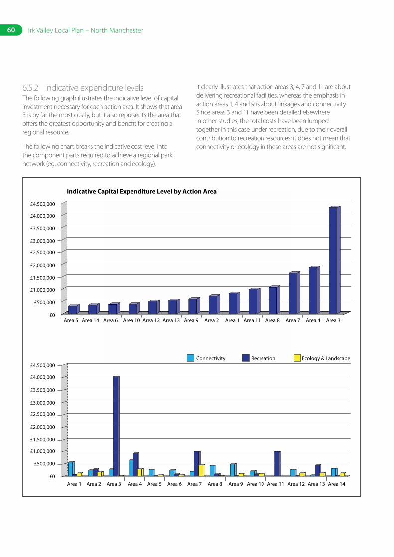
60 Irk Valley Local Plan – North Manchester
6.5.2 Indicative expenditure levelsThe following graph illustrates the indicative level of capital investment necessary for each action area. It shows that area 3 is by far the most costly, but it also represents the area that offers the greatest opportunity and benefit for creating a regional resource.
The following chart breaks the indicative cost level into the component parts required to achieve a regional park network (eg. connectivity, recreation and ecology).
It clearly illustrates that action areas 3, 4, 7 and 11 are about delivering recreational facilities, whereas the emphasis in action areas 1, 4 and 9 is about linkages and connectivity. Since areas 3 and 11 have been detailed elsewhere in other studies, the total costs have been lumped together in this case under recreation, due to their overall contribution to recreation resources; it does not mean that connectivity or ecology in these areas are not significant.
£4,500,000
Indicative Capital Expenditure Level by Action Area
£4,000,000
£3,500,000
£3,000,000
£2,500,000
£2,000,000
£1,500,000
£1,000,000
£500,000
Area 5 Area 14 Area 6 Area 10 Area 12 Area 13 Area 9 Area 2 Area 1 Area 11 Area 8 Area 7 Area 4 Area 3£0
£4,500,000
£4,000,000
£3,500,000
£3,000,000
£2,500,000
£2,000,000
£1,500,000
£1,000,000
£500,000
£0Area 1 Area 2 Area 3 Area 4 Area 5 Area 6 Area 7 Area 8 Area 9 Area 10
Connectivity Recreation Ecology & Landscape
Area 11 Area 12 Area 13 Area 14
7. Cost Report
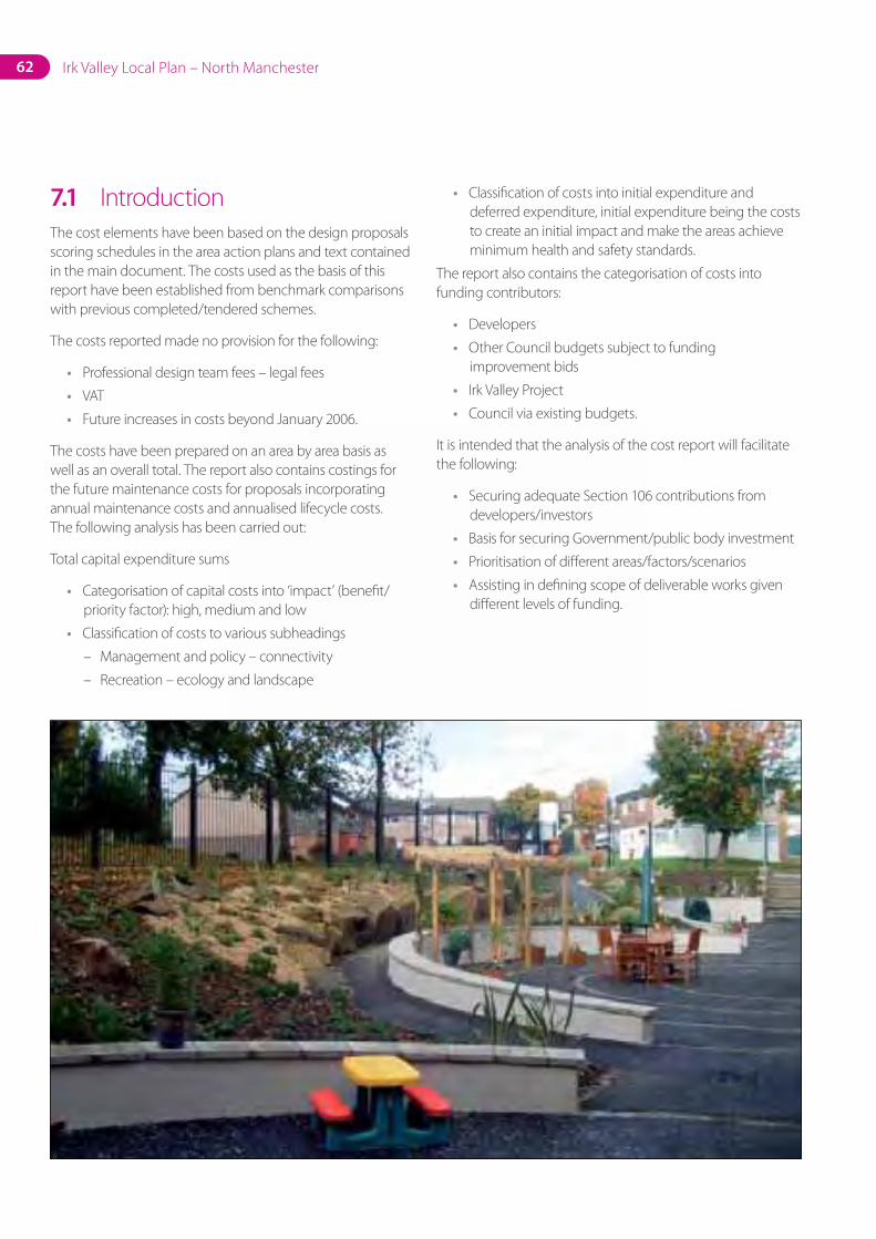
62 Irk Valley Local Plan – North Manchester
7.1 IntroductionThe cost elements have been based on the design proposals scoring schedules in the area action plans and text contained in the main document. The costs used as the basis of this report have been established from benchmark comparisons with previous completed/tendered schemes.
The costs reported made no provision for the following:
• Professional design team fees – legal fees
• VAT
• Future increases in costs beyond January 2006.
The costs have been prepared on an area by area basis as well as an overall total. The report also contains costings for the future maintenance costs for proposals incorporating annual maintenance costs and annualised lifecycle costs. The following analysis has been carried out:
Total capital expenditure sums
• Categorisation of capital costs into ‘impact’ (benefit/priority factor): high, medium and low
• Classification of costs to various subheadings
– Management and policy – connectivity
– Recreation – ecology and landscape
• Classification of costs into initial expenditure and deferred expenditure, initial expenditure being the costs to create an initial impact and make the areas achieve minimum health and safety standards.
The report also contains the categorisation of costs into funding contributors:
• Developers
• Other Council budgets subject to funding improvement bids
• Irk Valley Project
• Council via existing budgets.
It is intended that the analysis of the cost report will facilitate the following:
• Securing adequate Section 106 contributions from developers/investors
• Basis for securing Government/public body investment
• Prioritisation of different areas/factors/scenarios
• Assisting in defining scope of deliverable works given different levels of funding.
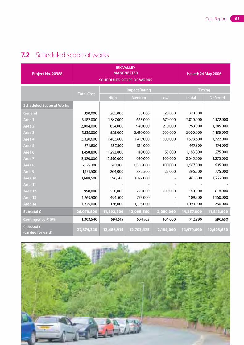
63Cost Report
7.2 Scheduled scope of works
ProjectNo.20988IRKVALLEY
MANCHESTER
SCHEDULEDSCOPEOFWORKSIssued:24May2006
TotalCostImpactRating Timing
High Medium Low Initial Deferred
ScheduledScopeofWorks
General
Area1
Area2
Area3
Area4
Area5
Area6
Area7
Area8
Area9
Area10
Area11
Area12
Area13
Area14
390,000
3,182,000
2,004,000
3,135,000
3,320,600
671,800
1,458,800
3,320,000
2,172,100
1,171,500
1,688,500
-
958,000
1,269,500
1,329,000
285,000
1,847,000
854,000
525,000
1,403,600
357,800
1,293,800
2,590,000
707,100
264,000
596,500
-
538,000
494,500
136,000
85,000
665,000
940,000
2,410,000
1,417,000
314,000
110,000
630,000
1,365,000
882,500
1092,000
-
220,000
775,000
1,193,000
20,000
670,000
210,000
200,000
500,000
-
55,000
100,000
100,000
25,000
-
-
200,000
-
-
390,000
2,010,000
759,000
2,000,000
1,598,600
497,800
1,183,800
2,045,000
1,567,000
396,500
461,500
-
140,000
109,500
1,099,000
-
1,172,000
1,245,000
1,135,000
1,722,000
174,000
275,000
1,275,000
605,000
775,000
1,227,000
-
818,000
1,160,000
230,000
Subtotal£ 26,070,800 11,892,300 12,098,500 2,080,000 14,257,800 11,813,000
Contingency@5% 1,303,540 594,615 604.925 104,000 712,890 590,650
Subtotal£(carriedforward)
27,374,340 12,486,915 12,703,425 2,184,000 14,970,690 12,403,650
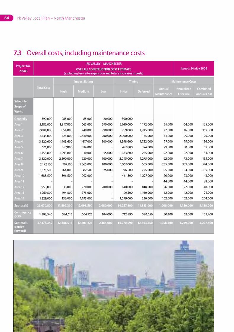
Irk Valley Local Plan – North Manchester64
7.3 Overall costs, including maintenance costs
Project No.
20988
IRK VALLEY – MANCHESTER
OVERALL CONSTRUCTION COST ESTIMATE (excluding fees, site acquisition and future increases in costs)
Issued: 24 May 2006
Total Cost
Impact Rating Timing Maintenance Costs
High Medium Low Initial DeferredAnnual
Maintenance
Annualised
Lifecycle
Combined
Annual Cost
Scheduled
Scope of
Works
Generally
Area 1
Area 2
Area 3
Area 4
Area 5
Area 6
Area 7
Area 8
Area 9
Area 10
Area 11
Area 12
Area 13
Area 14
390,000
3,182,000
2,004,000
3,135,000
3,320,600
671,800
1,458,800
3,320,000
2,172,100
1,171,500
1,688,500
-
958,000
1,269,500
1,329,000
285,000
1,847,000
854,000
525,000
1,403,600
357,800
1,293,800
2,590,000
707,100
264,000
596,500
-
538,000
494,500
136,000
85,000
665,000
940,000
2,410,000
1,417,000
314,000
110,000
630,000
1,365,000
882,500
1092,000
-
220,000
775,000
1,193,000
20,000
670,000
210,000
200,000
500,000
-
55,000
100,000
100,000
25,000
-
-
200,000
-
-
390,000
2,010,000
759,000
2,000,000
1,598,600
497,800
1,183,800
2,045,000
1,567,000
396,500
461,500
-
140,000
109,500
1,099,000
-
1,172,000
1,245,000
1,135,000
1,722,000
174,000
275,000
1,275,000
605,000
775,000
1,227,000
-
818,000
1,160,000
230,000
61,000
72,000
81,000
77,000
29,000
92,000
62,000
235,000
95,000
20,000
44,000
26,000
12,000
102,000
64,000
87,000
109,000
79,000
30,000
92,000
73,000
339,000
104,000
23,000
44,000
22,000
12,000
102,000
125,000
159,000
190,000
156,000
59,000
184,000
135,000
574,000
199,000
43,000
88,000
48,000
24,000
204,000
Subtotal £ 26,070,800 11,892,300 12,098,500 2,080,000 14,257,800 11,813,000 1,008,000 1,180,000 2,188,000
Contingency @ 5%
1,303,540 594,615 604.925 104,000 712,890 590,650 50,400 59,000 109,400
Subtotal £ (carried forward)
27,374,340 12,486,915 12,703,425 2,184,000 14,970,690 12,403,650 1,058,400 1,239,000 2,297,400
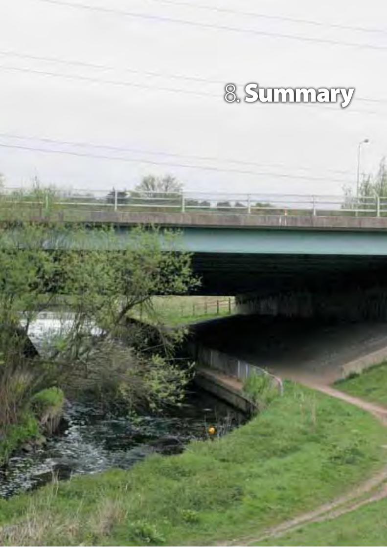
8. Summary
66 Irk Valley Local Plan – North Manchester
8. SummaryThe policies and proposals contained in this plan are intended to guide a concerted programme of action to enable the full potential of the Irk Valley to be achieved.
This will take a substantial effort by our partners and ourselves. Huge strides have been made in recent years, but much remains to be done to achieve the ambitions set out in this plan.
Manchester City Council is convinced that this effort will be worthwhile because the potential benefits for the wider regeneration of North Manchester are very large and very wide-ranging.
North Manchester is blessed with extensive green spaces but the benefits of these have not been fully realised. We are determined to ensure that this plan will become the catalyst to change that situation for the better for current and future generations of North Manchester people.