Embed Size (px)
Citation preview
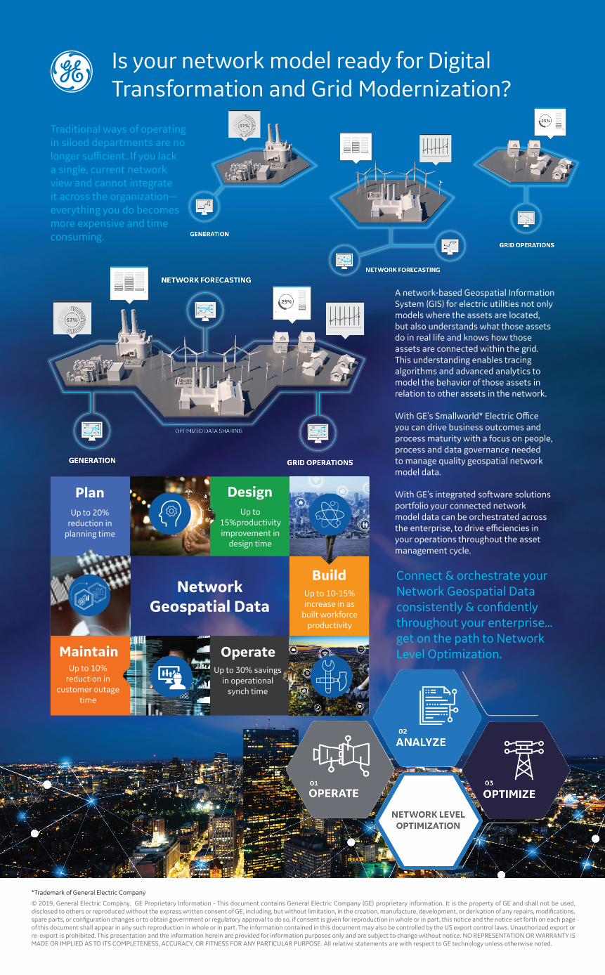
Traditional ways of operating in siloed departments are no longer sufficient. If you lack a single, current network view and cannot integrate it across the organization—everything you do becomes more expensive and time consuming.
Is your network model ready for Digital Transformation and Grid Modernization?
A network-based Geospatial Information System (GIS) for electric utilities not only models where the assets are located, but also understands what those assets do in real life and knows how those assets are connected within the grid. This understanding enables tracing algorithms and advanced analytics to model the behavior of those assets in relation to other assets in the network.
With GE’s Smallworld* Electric Office you can drive business outcomes and process maturity with a focus on people, process and data governance needed to manage quality geospatial network model data.
With GE’s integrated software solutions portfolio your connected network model data can be orchestrated across the enterprise, to drive efficiencies in your operations throughout the asset management cycle.
PlanUp to 20%
reduction in planning time
Up to 15%productivity improvement in
design time
Design
Up to 10-15% increase in as
built workforce productivity
Build
Up to 30% savings in operational
synch time
OperateUp to 10%
reduction in customer outage
time
Maintain
Network Geospatial Data
Connect & orchestrate your Network Geospatial Data consistently & confidently throughout your enterprise... get on the path to Network Level Optimization.
© 2019, General Electric Company. GE Proprietary Information - This document contains General Electric Company (GE) proprietary information. It is the property of GE and shall not be used, disclosed to others or reproduced without the express written consent of GE, including, but without limitation, in the creation, manufacture, development, or derivation of any repairs, modifications, spare parts, or configuration changes or to obtain government or regulatory approval to do so, if consent is given for reproduction in whole or in part, this notice and the notice set forth on each page of this document shall appear in any such reproduction in whole or in part. The information contained in this document may also be controlled by the US export control laws. Unauthorized export or re-export is prohibited. This presentation and the information herein are provided for information purposes only and are subject to change without notice. NO REPRESENTATION OR WARRANTY IS MADE OR IMPLIED AS TO ITS COMPLETENESS, ACCURACY, OR FITNESS FOR ANY PARTICULAR PURPOSE. All relative statements are with respect to GE technology unless otherwise noted.
*Trademark of General Electric Company