Embed Size (px)
Citation preview
ISLAND RESOURCES FOUNDATION
Caribbean Headquarters RED HOOK BOX 33. ST. THOMAS
U.S. VIRGIN ISLANDS 00802
(809) 775-6225
OLD SCHOONER CHANNEL PROPOSED DREDGING AREA
MARINE ARCHAEOLOGICAL SURVEY
CHRISTIANSTED HARBOR
U.S. VIRGIN ISLANDS
FOR
THE VIRGIN ISLANDS PORT AUTHORITY
FINAL REPORT
JULY-AUGUST, 1988
CONTRACTOR:
ISLAND RESOURCES FOUNDATION
W IZShington, D. C. Office 1718 P STREET. N.W .. SUITE T4
WASHINGTON. D.C. 20036
(202) 265-971 2
DR. EdwARD L. TOWLE JOHN RYTHER J. BARTO ARNOLD STEVE~ JAMES GEORGE TYSON NEIL COULSTON HANK TONNEMACHER
TEAM LEADER ENGINEER/EG&G MAGNETOMETERISURVEY SITE EVALUATIONS HISTORIAN DIVER DIVER


Table of Contents List of Figures
1. ABSTRACT
TABLE OF CONTENTS
1.1. Summary of Operations 1.2 Summary of Findings
2. BACKGROUND 2.1 Historical Setting 2.2. Maritime Traffic and Shipwrecks
in the Survey Area 2.3. Physical Setting
2.3.1. Dredging History 2.3.2. Aids to Navigation
3. NAVIGATION AND SURVEY INSTRUMENTS 3.1. Magnetometer Instrumentation 3.2. Survey Operations
4. MOBILIZATION AND ELECTRONIC SEARCH PROCEDURES
Page i i i
1 2
3 3
12 14 15 15
17 18 18
22
5. PHASE I - OPERATIONS 26 5.1. Field Survey Methodology 26 5.2. Phase I Anomaly Inspection Results 27
5.2.1. Anomaly 4/658 27 5.2.2. Anomaly 41/775 27 5.2.3. Anomaly 41/772 30 5.2.4. Anomaly 40/711 30 5.2.5. Anomaly 7/897 30 5.2.6. Anomaly 6/782 30 5.2.7. Anomaly 8/961 31 5.2.8. Anomaly 41/781 31 5.2.9. Anomaly 40/732 31 5.2.10. Anomaly 34/383 31 5.2.11. Anomaly 32/266 31 5.2.12. Anomaly 8/951 31 5.2.13. Anomaly 38/596 32 5.2.14. Anomaly 40/707 32 5.2.15. Anomaly 16/497 32 5.2.16. Anomaly 36/508 33
5.3. Anomalies 20/690, 10/692, 20/693 and 15/440 34
i

6. PHASE II 6.1. Results
6.1.2. Site 36/508 6.2. Site Clusters 20/690, 20/692, 20/693 6.3. Conclusions
REFERENCES APPENDIX Project Photographs
LIST OF FIGURES
Figure 1. Figure 2. Figure 3. Figure 4.
36/508 Site Map 20/693 Site Map Chain-Plate Hull Section
LIST OF TABLES
Table 1.
Table 2.
Table 3.
Table 4.
Table 5. Table 6. Table 7.
Table 8. Table 9. Table lOa. Table lOb. Table 11. Table 12.
Waterborne commerce in Christiansted Harbor, selective indicators 1759-1799. Waterborne commerce in Christiansted Harbor, selective indicators 1825-1889. Waterborne commerce of Christiansted Harbor, 1957. General location of Christiansted Harbor shipwrecks. Transponder site coordinates. Magnetometer survey line coordinates. Navigation marker and channel coordinates, Schooner Channel, Christiansted Harbor. Magnetometer survey line coordinates. Anomaly clusters, Schooner Channel Project. Investigated anomalies. Investigated anomalies in feet. Site 36/508 Artifact provenience. Site 20/693 - Test pit artifact provenience
i i
36 36 37 44 53
56 61
<.1 . ;
Page 38 45 48 50
Page
6
10
11
13 18 20
21 24 25 28 29 40 51
1. ABSTRACT
1.1. Summary of Operations
Preparatory to the dredging of the "Old Schooner Channel" in Christiansted Harbor, St. Croix, U.S. Virgin Islands, a marine archaeological study was conducted for the Virgin Islands Port Authority by Island Resources Foundation. The project Team Leader was Dr. E. L. Towle, a specialist in maritime history and marine resource management. The study consisted of a background history, a marine magnetometer survey, and an initial anomaly inventory, identification and evaluation. J. Barto Arnold conducted the magnetometer survey, and the anomaly inspection and assessment was supervised by Stephen R. James, Jr. Both are registered professional marine archaeologists. The purpose of this survey was to locate submerged cultural resources which in this case might include shipwrecks, small watercraft, lost or jettisoned cargo or submerged mi ddens.
Following procedures laid out in the Christiansted Harbor Marine Archaeological Plan prepared by the Island Resources Foundation on 1 February, 1987, and approved by the Virgin Islands Department of Conservation and Cultural Affairs pursuant to Coastal Zone Permit No. CZX-2-85W, the Foundation commenced field work on-site on 14 July, 1988.
Phase I of this submerged cultural resources survey of the "Old Schooner Channel" in Christiansted Harbor, St. Croix, was completed on 25 July, 1988, and resulted in the identification of over ninety (90) magnetic anomalies indicative of metallic (ferrous) objects or clusters of objects on the seabed in or near the channel running from Fort Louise Augusta to Fort Christiansvaern and the Gallows Bay turning basin. A detailed mapping and data display matrix of these various anomaly sites is provided (see appended engineering drawings - #1 - Survey Lines and #2 - Anomaly Chart).
From the initial universe of 90-odd sites turned up by the magnetometer sweeps, twenty-four (24) that met certain criteria were selected for detailed inspection and investigation by various methods as per the original approved methodology and survey plan. (see appended engineering drawing entitled, "Investigated Anomalies"). Out of this group which were investigated in some detail, only two sites (actually clusters) appeared to be:
a. archaeologically and historically significant, b. candidates for an expanded evaluation, c. possible candidates for a salvage archaeology
undertaking prior to dredging.

OLD SCHOONER CHANNEL, CHRISTIANSTED, ST. CROIX MARINE ARCHAEOLOGICAL SURVEY - JULY/AUGUST 1988
PAGE 2
A Phase II assessment of these target sites was mounted from 26 July to 4 August, 1988 (eight full-team working days).
1.2 Summary of Findings
No anomaly sites of significance were found in the areas scheduled to be dredged. Well outside (over 100 feet) the proposed channel and on the edge of Round Reef itself, there is one cluster of nominally significant sites for which caution is needed to avoid any direct physical damage during the dredging activity. Apart from this, there is no reason from a cultural assessment perspective, why the proposed dredging should not be allowed to proceed as planned.

2. BACKGROUND
OLD SCHOONER CHANNEL, CHRISTIANSTED, ST. CROIX MARINE ARCHAEOLOGICAL SURVEY - JULY/AUGUST 1988
PAGE 3
2.1. Historical Setting
The Schooner Channel survey area encompasses one of the main navigational channels and anchorages of Christiansted Harbor. Through it has passed much of the shipping that has frequented this busy port since initial European settlement commenced in the mid-seventeenth century. The history of this port, called "Bassin" prior to the commencement of American sovereignty, provides the general context for identifying and understanding any shipwrecks or other submerged cultural remains that might be found within the survey area.
Maritime usage of Bassin commenced with prehistoric seafarers, who established several settlements along the harbor shoreline, on Protestant Cay and at Altona Lagoon, during an occupation lasting from approximately 1500 A.D. to 1550 A.D. (Figueredo and Tyson, 1985a; 1985b). It is impossible to establish the extent of prehistoric maritime activity within the survey area from available archaeological evidence. There are strong indications that later prehistoric peoples on St. Croix actively 'participated in an inter-island trade network that included, minimally, the northern Virgin Islands and Puerto Rico (Figueredo, 1978bj Johnston and Lundberg, 1983). While the intricate nature of the harbor entrance would not have posed serious difficulties for the small, manually propelled, Indian watercraft under normal circumstances, there is a high probability that some sort of marine accident occurred in this hazardous area during such a long period of human enterprise.
In the historic era, port development along the harbor's southern shoreline, at the site where the town of Christiansted is now located, seems to have been initiated in 1642 by a party of Dutchmen, representatives of a European maritime power that established New World colonies essentially as maritime trading outposts rather than plantation societies (Lewisohn, 1970; Figueredo, 1978a). Although the Dutch harbor settlement lasted only until 1645_ when it was conquered by English planters also living on St. Croix, it appears to have engaged in a rather active trade with its mercantile sponsors in Holland (Lewisohn, 1970).
English colonists controlled St. Croix between 1645 and 1650. In the latter year, after a brief period of warfare, the island fell to the French, whose sovereignty lasted until 1696. In contrast to the English, who had

OLD SCHOONER CHANNEL, CHRISTIANSTED, ST. CROIX MARINE ARCHAEOLOGICAL SURVEY - JULY/AUGUST 1988
PAGE 4 concentrated their maritime activities at Frederiksted and~ to a lesser degre~, at Salt River, the French reoccupied the old Dutch harbor settlement (Lewisohn, 1970) which they called "St. Jean" (Caron and Highfield, 1978; 1980). The harbor, which they named Bassin, became their primary commercial port, although they also made considerable use of Salt River.
The extent of urban growth and maritime activity at Bassin during the period of French sovereignty (1650-1696) is difficult to measure from available source material. Indications are that the volume of seaborne commerce was rather low. Maritime trade was discouraged because the island was governed by strict mercantile principles restricting commerce to French shipping. Yet few French vessels ever called at St. Croix, resulting in frequent shortages of essential supplies, and prompting chronic discontent among the colonists (Caron and Highfield 1980; Caron 1982). In consequence, French Cruzans actively engaged in clandestine, and occasionally legal, trade with the surrounding Danish, Dutch, English and Spanish islands.
Thus, ships of all the major colonial powers called at St. Croix during the second half of the seventeenth century, exchanging cargoes of general merchandise, foodstuffs, indentured servants and slaves for local plantation products, such as sugar, ginger1 indigo, cotton, hardwoods, and, above all, tobacco (Caron and Highfieldp 1978). Much of the smuggling undoubtedly took place at out bays around St. Croix. However, because leading government officials sometimes were either directly involved, or chose to tolerate it, a fair amount must have occurred at Bassin.
One indication of the low volume of maritime activity is that throughout the French period, St. Jean remained little more than a hamlet. A French map of 1682 showed the settlement with only ten houses and a church. Since the island-wide population remained constant at around 1200 souls between that date and the evacuation of 1696, and the trade doldrums seem to have persisted through 1696 (Caron, 1982), there is no reason to suppose that any significant expansion of port development or trade took place during the last years of French occupation.
Between 1696, when the French voluntarily evacuated St. Croix, and 1734, when the Danish occupation began, St. Croix was largely uninhabited. However, mariners, pirates and woodcutters periodically visited the harbor during this interregnum. Around 1729 a party of Englishmen from the Leeward Islands established an unauthorized colony in the center of the island. Their maritime cutlet cannot be

OLD SCHOONER CHANNEL, CHRISTIANSTED, ST. CROIX MARINE ARCHAEOLOGICAL SURVEY - JULY/AUGUST 1988
PAGE 5 ascertained (Lewisohn, 1970). However, they appear not to have used Bassinp which the Danes found unoccupied when they made their first reconnaissance of St. Croix in 1734 (Hornby, 1985).
The Danes, who assessed the entrance to Bassin as "dangerous but passable," decided to make it their main port because it could be easily defended and provided a protected anchorage (Hornby, 1985). Under their rule Bassin was transformed into a thriving center of maritime commerce. They established a new town named Christiansted on the former site of St. Jean, and made it their administrative center. During the second half of the eighteenth century, Christiansted expanded from a small village into a major town of some 664 buildings and 5000 residents (Vibaek, 1966; Svenssonr 1965; Hornby, 1985). The basis of this growth was the maritime commerce that flowed in and out of the harbor.
St. Croix, of course, was dominated by the plantation system, which produced tropical staples - sugar, cotton, rum and mclasses, for export into the world market economy. Historically, while Christia~sted served as the seat of government and producer of some goods and services for the surrounding countryside, it functioned, like most Caribbean seaports, primarily as a collection and distribution center for outgoing plantation products and incoming plantation supplies. The volume and nature of its maritime trade, therefore, depended largely upon the prosperity of the plantations.
Locally ava11able data respecting the extent of waterborne commerce passing through Christiansted Harbor during the second half of the eighteenth century is presented in Table 1. It shows that between 500 ~nd 1350 vessels entered Christiansted Harbor annually between 1759 and 1799 , a rather substantial volume, which approximated that of St. Thomas during the same period (Tyson, 1986). While no shipping statistics exist for the 1790's, the Customs receipts for this decade indicate a volume of trade surpassing that of 1782 1 when 1342 vessels entered the harbor.
The figures for ship arrivals are, however, somewhat misleading~ as European nations in the Caribbean were at war during all but one of the years represented. During these wars maritime activity in neutral Danish ports rose far higher than usual (Willis, 1963). Thus, in 1789, a year of peace, there were only 518 arrivals, compared to 1342 in 1782. On the other hand, it must be borne in mind that European nations were at war half of the time between 1759 and 1799.

Table 1.
Year
OLD SCHOONER CHANNEL, CHRISTIANSTED, ST. CROIX MARINE ARCHAEOLOGICAL SURVEY - JULY/AUGUST 1988
PAGE 6
Waterborne commerce in Christiansted Harbor, selective indicators 1759-1799.
Total North American CIJ stoms Receipts Arrivals Vessels (Rigsdollars)
--------------------------------------------------1759 739 71 1760 668 61 1762 597 63 1762 698 53
1764 126
1766 171
1769 185
1773 198 1774 173 75,153 077.5)
1777 908 154
1779 997 57,139 1780 1000 72,071 1781 1146 89,447 1782 1342 145 119,769 1783 1198 76,069
1785 174 75,344 1786 172 1787 173 90,064
1789 516 135 1790 152 74,594
1793 129,914
1797 205 139,927 0796 ) 1798 114 111,567 1799 108 194,422
Sources: 8ergsoe 1853; Westergaard 1917; Willis 1963

OLD SCHOONER CHANNEL, CHRISTIANSTED, ST. CROIX MARINE ARCHAEOLOGICAL SURVEY - JULY/AUGUST 1988
PAGE 7 No information on departures has been found. However, since virtually all ships entering the harbor departed from it, it can be establ i shed that, on average, around 1500 vessels annually negotiated the tricky harbor entrance during the last half of the eighteenth century.
What was the nature of this eighteenth century commerce? The ships involved were primarily Danish, American, English, and, to a lesser degree, French and Spanish (Puerto Rican). Although Denmark attempted to monopolize the com~ merce of St. Croix for herself through the imposition of regulations (Dookhan, 1974)~ wartime exigencies/opportunities, coupled with the need of the plantations for a larger market and more goods than Denmark could provide, dictated that certain segments of St. Croix's trade be opened up to other nationalities upon payment of relatively low duties. Thus, it can be seen from the data presented in Table I, the American share of total shipping fluctuated between 10 and 15 percent during wartime, and climbed to about 25 percent in peacetime.
Writing around 1767, a year of peace, Oldendorp (1770) described the incoming trade of St. Croix as follows:
The Danes bring all kinds of their own goods, as well as German, East In~ian, and Chinese wares. Those include East Indian handkerchiefs, chintz and other fabrics, Danish and German linen, and diverse materials pertaining to clothing. In addition, they bring pepper, tea, sago, salted and smoked meat, ham, sausage, biscuits, dried cod and other salted fish, beer, groats, peas, oats, wax, gl asses, i ron, axes~ na i 1 s, boards, rigging, bricks, earthen plates and bowlsp porcelain, mules from Marseilles, and wine from Madeira. English ships coming from North America bring oxen and horses, bacon, flour, lard, butter: oats, corn, or Welsh corn, biscuits] tallow candles, wax and whale oil, candles, timber, beams, boards, sh i ngl es, spars and al so Madeira wine. From Ireland, Danish ships often bring salted fish: bacon, butter, and can-dles •••• From Porto Rico, the Spaniards bring mules, oxen, cows, horses, poultry, coffee,· cacao, cowhides, campeche wood, fustic and pockwood.
One important commodity unmentioned by Oldendorp was human beings, slave laborersl who were imported from Africa and West Indian islands and re-exported to North America and other Caribbean slave colonies until the Danish slave trade was abolished in 1803. As demonstrated by GreenPedersen (1971), an extensive exchange of slaves took

OLD SCHOONER CHANNEL, CHRISTIANSTED, ST. CROIX MARINE ARCHAEOLOGICAL SURVEY - JULY/AUGUST 1988
PAGE 8 place in Christiansted Harbor, and many local merchants were deeply involved in it. According to Green-Pedersen (1971), the inter-island slave trade was conducted in barks~ which Oldendorp (1770) described as a "small, light sailing vessel [with] only one diagonal mast, four sails and a small cabin~" while slaves were brought from Africa in larger vessels such as frigates, scows and packet boats.
Willis (1963) found that most of the trade with North America was transported in small, American-owned vessels, such as sloopsl schooners sand barkentines. She also notes that small vessels owned by Cruzan and St. Thomian merchants occasionally sailed between St. Croix and North America. These locally owned craft also participated in a mini-triangular trade between St. Croix; St. Thomas and St. John, with fruit, timber, coffee and sometimes slaves being brought into Christiansted from the latter island. Christiansted Harbor was also frequented by locally owned, coastal droghers carrying supplies to, and agricultural products from, coastal plantations.
The Cruzan sugar economy, and, in conjunction, harbor commerce, flourished between 1780 and 1820. Although shipping statistics for the early decades of the nineteenth century are not locally available, there can be little doubt that harbor visitations remained at high levels. The English occupations of 1801-1802 and 1817-1815, did sever trade links with Denmark; and, for some years; disrupted those with the United States and the French West Indies, but these losses were compensated for by increased exchange with Great Britain and her extensive West Indian possessions.
After 1820, however, the sugar industry fell on hard times due to falling prices, declining labor productivity and drought conditions (Dookhan, 1974). The volume of Bassin's waterborne commerce contracted in line with declining agricultural outputs and lowered demand for imported plantations supplies and consumer goods. Concurrently, partly in response to changing economic conditions and partly because of technological advances; larger vessels, including steamships, began to be used in the sugar trade. Thus, much of that trade began to by-pass Christiansted in favor of the uncomfortable, but safer Frederiksted anchorage. Christiansted's commerce was increpsingly limited to its trading partners elsewhere in the West Indies, most of whom were also affected by the general trade depression.
OLD SCHOONER CHANNEL, CHRISTIANSTED, ST. CROIX MARINE ARCHAEOLOGICAL SURVEY - JULY/AUGUST 1988
PAGE 9 In an effort to stimulate trade, Denmark c01ferred virtual free port status on St. Croix in 1833 (Dookhan, 1974). For Bassin it was a case of too little, too late, for by the 1860's, if not earlier, that harbor had been replaced as St. Croix's main port by Frederiksted, which was cater-ing to roughly 70 percent of all incoming tonnage (Rainals, 1865; Turner, 1889).
By the second half of the nineteenth century the British consular representative reported that Christianstedts trade had fallen off considerably compared to earlier periods (Rainals, 1865). This decline is documented in Table 2, which should not be directly compared to Table I, since the nineteenth century shipping data does not include small, inter-island sailing vessels, which remained the mainstay of Christiansted's commerce. However, the figures for American shipping in the two Tables are comparable, and they show a dramatic decline.
As can be seen from Table 2, most of the large vessels entering Christiansted Harbor were either American or British. Danish shipping had become rather insignificant. Other nationalities occasionally calling at Bassin were Germansp Spanish, Dutch, Swedes and Norwegians. The British ships all came via other West Indian islands, as there was no direct trade between St. Croix and Great Britain (Rainals~ 1865).
According to another British consular agent (DuBois, 1869):
The trade of British vessels. to [St. Croix] is chiefly confined to the adjacent islands, in most instances entering with cargoes of vegetables, salt, passengers, or ballast, and clearing in American provisions and building materials purchased on the spot. The importations by Danish and foreign vessels consist of plantation supplies, provisions, dry goods and engine coalsl and the exports of sugar, rum and molasses to Denmark and the United States.
Statistical data respecting shipping in Christiansted Harbor during the first half of the twentieth century could not be found in local sources. Impressionistic documentation, however, indicates that trade continued to stagnate, along with the agricultural economy, until at least the 1950's. Zabriskie (1918) observed that at the time the Virgin Islands were sold to the United States, Frederiksted still served as St. Croix's principle port, while most of Bassin's shipping was confined to inter-island sloops. Only during the sugar harvest did few large steamships venture into the harbor. The same sit~ation
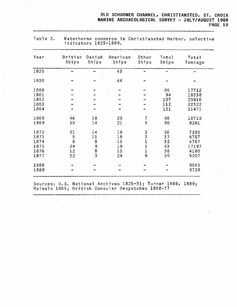
Table 2.
Year
1825
1830
1860 1861 1862 1863 1864
1868 1869
1872 1873 1874 1875 1876 1877
1888 1889
Sources: Rainals
OLD SCHOONER CHANNEL, CHRISTIANSTED, ST. CROIX MARINE ARCHAEOLOGICAL SURVEY - JULY/AUGUST 1988
PAGE 10
Waterborne commerce in Christiansted Harbor, selective indicators 1825-1889.
British Danish American Other Tota.l Total Ships Ships Ships Ships Ships Tonnage
----------------------43
44
90 17712 94 18338
107 23816 112 22322 131 21471
46 18 25 7 96 10712 50 14 21 5 90 8281
21 14 18 3 56 7300 5 11 18 3 37 6757 8 8 15 1 32 4707
24 9 19 1 53 17197 12 8 15 1 36 4180 32 3 24 0 59 5207
8065 9728
U. S. National Archives 1825-31; Turner 1888, 1889; 1865; British Consular Despatches 1868-77

OLD SCHOONER CHANNEL, CHRISTIANSTED, ST. CROIX MARINE ARCHAEOLOGICAL SURVEY - JULY/AUGUST 1988
PAGE 11 was observed by Jennings (1938) and the authors of the U.S. Coast Pilot (United States Coastal and Geodetic Survey, 1939). In the 1930's and 1940's various American governors (1930-1966), bemoaning the lack of maritime activity at Christiansted, advocated dredging of the harbor to stimulate navigation, but nothing came of these proposals until 1962.
Table 3 presents a picture of Christiansted's waterborne commerce at mid-century, and although shipping appears to have increased after World War II, it probably is fairly representational of the general situation since 1900.
-----------------------------------------------------------------Table 3. Waterborne commerce of Christiansted Harbor, 1957.
Vessel Type
No. of Arrivals
Cargo (Short tons)
Average Load per Vessel
Schooners 230 14,100 61. 2
8.3
16.0
Sloops 284 2,350
Motor Vessels 272 4,350
Barges 1.7 159.0
TOTALS: 803 23,500
Source: Tippetts-Abbett-McCarthy-Strattonl 1958.
In summary, during the historic era, Christiansted Harbor experienced a rather low volume of shipping until 1750, when commerce began a rapid expansion that lasted until 1820. During the peak period, around 1800, as many as 3000 vessels (incoming plus outgoing) of all sizes and all nationalities, annually traversed the hazardous harbor entrance. The flow of maritime traffic steadily fell off after 1820, and vessel size became smaller. By the 1860's Christiansted had been superseded by Frederiksted as St. Croix's major port. During the next century it was a commercial backwater, frequented almost exclusively by small, inter-island sailing vessels.
OLD SCHOONER CHANNEL~ CHRISTIANSTED~ ST. CROIX MARINE ARCHAEOLOGICAL SURVEY - JULY/AUGUST 1988
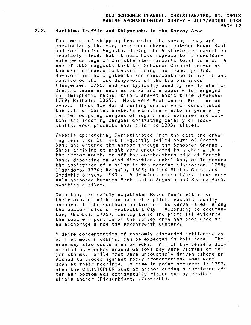
PAGE 12 2.2. Maritime Traffic and Shipwrecks in the Survey Area
The ~mount of shipping traversing the survey area, and particularly the very hazardous channel between Round Reef and Fort Louise Augusta, during the historic era cannot be precisely fixed, but it must have represented a considerable percentage of Christiansted Harbor's total volume. A map of 1682 suggests that the Schooner Channel served as the main entrance to Bassin during the French period. However, in the eighteenth and nineteenth centuries it was considered the most dangerous of the two entrances (Haagensen, 1758) and was typically used by small, shallow draught vessels, such as barks and sloops, which engaged in hemispheric rather than trans-Atlantic trade (Freneau, 1779; Rainals, 1865). Most were American or West Indian owned. These New World sailing craft, which constituted the bulk of Christiansted's maritime visitors, generally carried outgoing cargoes of sugar, rum1 molasses and cotton, and incoming cargoes consisting chiefly of foodstuffs, wood products and, prior to 1803, slaves.
Vessels approaching Christiansted from the east and drawing less than 10 feet frequently sailed south of Scotch Bank and entered the harbor through the Schooner Channel. Ships arriving at night were encouraged to anchor within the harbor mouth, or off the northeastern edge of Scotch Bank, depending on wind direction, until they could secure the a55~~tance of a pilot in the morning (Haagensen~ 1758; Oldendorp, 1770; Rainalsl 1865; United States Coast and Geodetic Survey, 1939). A drawing, circa 1765, shows vessels anchored between Fort Louise Augusta and Scotch Bank, awaiting a pilot.
Once they had safely negotiated Round Reefp .either on their own, or with the help of a pilot, vessels usually anchored in the southern portion of the survey area, along the eastern side of Protestant Cay. According to documentary (Barbot, 1732), cartographic and pictorial eviderce the southern portion of the survey area has been used as an anchorage since the seventeenth century.
A dense concentration of randomly discarded artifacts, as well as modern debris, can be expected in this zone. The area may also contain shipwrecks. All of the vessels documented as wrecked around Gallows Bay were victims of major storms. While most were undoubtedly driven ashore or dashed to pieces against rocky promontories, some went down at their moorings. A case in point occurred in 179?, when the CHRISTOPHER sunk at anchor during a hurricane after her bottom was accidentally ripped nl~t by another ship's anchor (Rigsarkivet, 1778-1800).

OLD SCHOONER CHANNEL. CHRISTIANSTED. ST. CROIX MARINE ARCHAEOLOGICAL SURVEY - JULY/AUGUST 1988
PAGE 13 The lower half of this historic anchorage was included in a dredging permit issued to the Corps of Engineers in the early 1960's (NichJls, 1972). But, because this area shoaled appr~~1~ately one meter between 1794 and 1924 (Nichols, 1972), and because in many places its depth exceeded the controlling dredge depth of 18 feet, there is a very good possibility thet the dredging missed, or only partially dist~rbed, submerged historical contexts.
For sailing shipsl exiting the harbor was perhaps more difficult than entering because prevailing winds blew from the north or northeast. To make departures safer, the Danes placed permanent anchors along the two channels on either side of Round Reef. Merchantmen made their way past Round Reef to the harbor mouth by wraping up to these anchors. Once they had sa¥ely negotiated Round Reef, they then set thei r' sai 1 5 and cast off.
The intricate entrances to Christiansted Harbor~ and particularly the Schooner Channel, were acknowledged by all sources consulted in this background study to pose serious threats to shipping. The probability of encountering shipwreck remains in the northern portion of the survey area is, therefore, extremely high. Indeed, as ear1y as 1687 a french official stated that the Schooner Channel "has so many rocks that a lot of boats are shipwrecked there" (Lewisohn~ 1970). This, however, is the only specific reference to wrecks within the survey area that has been found.
Severa1 eccounts of marine disasters at the harbor entrance have been unearthed by our research. In 1717 two pirate ships were sunk at the harbor mouth during an engagement with a British man-of-war (Lewisohn, 1970). Other sinkings at the entrance were reported in 1772, 1806, and :'.855 (Tyson: 1983). The newspaper notice of the 1772 wreck stated that there had been "repeated accidents" to vessels trying to enter the harbor at night (Royal Danish American GazetteJ 1772).
Inventories of Virgin Islands shipwrecks (Marx and Towle, 1971; Tyson. 1983) list a total of 40 recorded marine disasters at Christiansted Harbor between 1523-1928. Table 4 classifies them by location.
Table 4. General location of Christiansted Harbor shipwrecks.
-----------------------------------------------------------------Entrance Xsted Scotch Gallows Prot. Fort Ashore Harbor __________ ~~1____B~ _____ ~~¥----~~¥ .~C~h~. __________________ _
5 9 1 4 1 2 8 10
Source: Tyson 1983

OLD SCHOONER CHANNEL, CHRISTIANSTED, ST. CROIX MARINE ARCHAEOLOGICAL SURVEY - JULY/AUGUST 1988
PAGE 14
As can be seen from Table 4r only 5 of the reported wrecks occurred at the harbor entrance, an imprecisely defined area that is not confined to the Schooner Channel. However, it should be noted that the location of most of the other wrecks is al~o poorly defined, and that it 1s certainly possible that of the 27 vessels reported to have gone down on Christiansted Reef, Scotch Reef, or within Christiansted Harbor, one actually sunk within the survey area~ Ooe or more of the 5 vessels wrecked i~ Gallows Bay or at Protestant Cay may also have been within the southern portion of the survey area.
Examination of a large number of nautical charts and aerial photographs t.aken between 1946 and 1978 failed to find any evidence of shipwrecks within the study ~rea.
2.3. Physical Setting
Historically known as the "Bark" or "Schooner" Channel because it was generally used by smallp shallow draught vesselsp this narrow waterway passes on the east side of Round Reef and extends southward to an anchorage basin along the east side of Protestant Key.
The earliest representation of this channel, a French map of 1682, shows the harbor and the Schooner Channel to have the same physical configuration then as now (DeJonghp 1983). Writing about the same time, an English mariner (Barbot, 1732) described the harbor as being "very safe, ••• but somewhat difficult to get inl having two very narrow channels among the rocks1 not above six fathoms broad, and the one fifteen, end other sixteen foot water. Within those narrow channels the depth increases to four and five fathom •••• "
Almost two centuries later, th9 British consular agent also stated (Rainals, 1865) that the harbor could safely accommodate vessels of 15 to 16 foot draught. However, possibly in consequence of a major earthquake in 1867, and/or severe hurricanes of 1899, 1916 and 1928, the outer harbor seems to have shoaled up to a meter between 1865 and 1971 (Nicholsl et al.; 1972). In 1939 the U.S. Coastal Pilot (United States Coastal and Geodetic Survey, 1939) stated that the Schooner Channel had a controlling depth of just 14 feet. In 1958 a survey (TIbbetts, at al.) reported the harbor to be "capable of accommodating only vessels with a draft of 12 feet or less."

2.3.1.
OLD SCHOONER CHANNEL, CHRISTIANSTED, ST. CROIX MARINE ARCHAEOLOGICAL SURVEY - JULY/AUGUST 1988
PAGE 15 Dredging History
Although Danish and American authorities (Governor of the Virgin Islandsl 1930-1966) periodically urged the dredging of Christiansted Harbor to improve navigation, it appears that the first dredging did not occur until 1962, when the Corps of Engineers excavated a turning basin at Gallows Bay to a controlling depth of 18 feet <Governor of the Virgin Islandsl 1962; Nichols, et al., 1972). Harbor dredging waS most intense between 1962 and 1972, when over 600,000 cubic meters was removed (Nichols~ at al., 1972; Insular Environments, 1973).
Analysis of documentation, aerial photographs and nautical charts show that dredging in the survey area has been confined to two areas: 1) the southern portion between Gallows Bay end Protestant Key; and, 2) along the eastern edge between Fort Louise Augusta and Mount Welcome. Approximately 150,000 cubic yards of material was removed from the latter site, which was cut down to 18 feet below Mean Water Level (Insular Environments, 1973). However, according to one source (Insular Environments, 1975), little or no material was actually removed from the portion of the dredge site that borders the survey area.
Aids to Navigation
None are shown on the maps of 1735» 1756, 1778. On the 1794 Oxholm map there are two buoys between the bank off Fort and Scotch Bank - one of these is close to a definable shallow area where a buoy is placed today; one on the west side of Round Rock, one on Point of Little Middle Ground; and, one off 50uthern part of Great Middle Ground near a shallow area.
However, these are in the same location as warping anchors on 1803 chart, so they may not be navigational buoys.
The Ingolf, 1906 map displays buoys as follows:
A. Two ( 2 ) well into Scotch Bank
B. One ( 1 ) off southern part of Great Middle Ground
C. One ( 1 ) off western side of Great Middle Ground
D. One ( 1 ) off nQrthwestern point of Round Rock~ well north of the Fort
E. One ( 1 ) off western side of Round Rock

OLD SCHOONER CHANNEL, CHRISTIANSTEO, ST. CROIX MARINE ARCHAEOLOGICAL SURVEY - JULY/AUGUST 1988
PAGE 16 F. One (1) on Little Middle Ground Point
G. One (1) off southern side of Round Rock, north of Little Middle Point
Warping anchor sites were inspected but no evidence, magnetic or visual, suggested the existence of surviving remains of this "artifact" of the days of sailing ships.

OLD SCHOONER CHANNEL_ CHRISTIANSTED_ ST. CROIX MARINE ARCHAEOLOGICAL SURVEY - JULY/AUGUST 1988
PAGE 17
3. NAVIGATION AND SURVEY INSTRUMENTS
Positioning for the Schooner Channel Marine Archaeological Survey was accomplished with a brand new Racal Microfix STM 1104 Navigation System. The Microfix 1s a short-range positioning fixing system which combines established microwave ranging techniques with advanced microprocessor technology to provide a number of excellent survey features and a repeatable accuracy of ± meter.
The control measurement unit (eMU) of the Microfix aboard the vessel can obtain ranges from up to eight shore-based microwave transponders. Ranges in meters between master and remote stations are displayed to a resolution of 0.1 meter and corrected for height differences (slant range correction). Up to 220 interrogations of a remote station are made to obtain a single range, and samples can be updated as often as once a second. Filtering is also conducted to improve range quality. Using a least-squares solution, x-y positions in the specified grid system are calculated and displayed.
The Microfix is interfaced to an Hewelett Packard (HP), 13-inch video monitor, HP Model 7470A Flatbed Plotter, Texas Instruments (TI) Printer, and Zenith Laptop logging computer. This system provides a steering display for the helmsman, enabling the vessel to follow a predetermined trackline. The monitor display includes a left-right steering indicator, and provides the distance offline, the distance to the end of the line, the course to steer~ and the speed over the ground.
With the Microfix, a block of equally spaced survey lines can be defined and drawn as a preplot on the HP plotter, and the vessel's position in relation to the preplotted tracklines plotted in real time. In addition, up to 18 waypoints or x-y positions can be stored in memory in the Microfix, and the video display and plotter utilized to guide the vessel to the waypoint.
Using the Zenith computer and TI Serial Printer, fix marks, time, ranges and x-y positions are recorded on disc and printed. Fix marks are also generated over a selectable time interval or distance traveled along a trackline. The fix mark number is displayed on the monitor, labeled on the plotter, and an event mark transmitted to the survey peripherals.

OLD SCHOONER CHANNEL. CHRISTIANSTED. ST. CROIX MARINE ARCHAEOLOGICAL SURVEY - JULY/AUGUST 1988
PAGE 18 At each fix mark, time, x-y positions, and ranges were recorded on disc, printed on the TI Serial Printer, and an event mark transmitted to the strip chart on the magnet-ometer. To relocate and refine anomaly positions, a list of the fix marks corresponding to the sensor location at the time of anomaly detection was tabulated. These were entered as waypoints in the Microfix system, and the plotter and video display utilized to reposition the vessel at these locations.
3.1. Magnetometer Instrumentation
To locate underwater objects and identify areas of archaeological significance, the Geometrics Model G-866 Recording Proton Magnetometer was utilized. The G-866 is a portable, high-resolution magnetometer with a sensitivity of 0.1 gamma. It is equipped with a dual-trace thermal recorder which provides permanent records of analog chart records annotated with exact readingsl time, date, and scale factors. It also provides a digital display of the magnetic data and an RS-232 output for interfacing to portable field computer for storage and processing of the raw data.
The 866 is furnished with a marine sensor or "fish" and a 20-foot length of cable, permitting towing well away from the vessel.
Land surveying of the shore-based transponder locations was conducted on St. Croix by Antillean Engineering. To provide adequate coverage of the survey area, four sites were selected and transponder locations changed as necessary. Sites were chosen at Fort Louise Augusta, Mount Welcome, the home of Mr. Frank Diablo on Recovery Hill, and at the Costa Verde Condominiums. X-y co~rcinatesl expressed in feet in the Puerto Rico State Grid system, and elevations for the transponder sites are presented below.
Table 5. Transponder site coordinates.
1. 2. 3 J
4.
Location
Questa Verde Recovery Hill Welcome Hill Fort Louise
Northing
68419.7 69906.7 72736.4 75141.04
Easting
1098400.3 1103946.3 1104268.9 1104884.6
Elevation
260.5 291.2 85.5 35.3
OLD SCHOONER CHANNEL, CHRISTIANSTED, ST. CROIX MARINE ARCHAEOLOGICAL SURVEY - JULY/AUGUST 1988
PAGE 19 These coordinates were converted to meters and entered into the Microfix system. All plotted positions of vessel tracklines and anomaly x-y coordinates during the survey are expressed in meters but for the survey charts, are converted back to feet.
Due to the long narrow shape and changes in the direction of the Schooner Channel, the survey area was divided into three separate grids. Grid 1 consisted of eight northsocth lines, extending from the channel entrance from Lt. 7 to Buoy #2. Grid 2 was comprised of nine northeasterly lines, extending from Buoy #2 to Lt. 13. Grid 3 contained 15 northerly tracklines extending from Lt. 13 to Protestant Key and the Gallows Bay dock, and included the turn-ing basin area. For all three survey grids, 20-meter line spacings were observed (see Charts).
For Grids 1 and 2» all survey lines were run from north to south to reduce noise on the magnetometer, and the layback of the sensor from the navigation antenna was 25 meters. Due to the calmer seas in the inner harbor and the requirement for tighter turns, on Grid 3, lines were run in both directions and the cable length reduced for a total layback of 10 meters (see Table 6). To obtain navigation fixes at the sensor location when an anomaly was detected, the Microfix was programmed to provide fix marks over distance traveled, and the distance was adjusted to match the distance of the sensor from the mast of the ship.
Day beacons, navigational marks and channel coordinates delineating the area to be dredged are displayed in Table 7.

Table 6.
OLD SCHOONER CHANNEL, CHRISTIANSTED, ST. CROIX MARINE ARCHAEOLOGICAL SURVEY - JULY/AUGUST 1988
PAGE 20
Magnetometer survey line coordinates.
LLne start of LLne(ft) end of LLne(ft) no. x !:l x !:l
01 74948.0 1104271.0 73947.6 1103048.0 02 73855.8 1103028.0 74918.5 1104323.0 2A 74898.8 1104278.0 73750.8 1102952.0 03 74925.0 1104373.0 73783.6 1103044.0 04 74885.7 1104438.0 73698.3 1103038.0
05 74793.8 1104409.0 73698.3 1103146.0' 06 74757.8 1104533.0 73458.9 1102936.0 07 74721.7 1104543.0 73583.5 1103231.0 . 08 74639.7 1104550.0 73216.2 1102906.0 09 74570.8 1104622.0 73321.1 1103090.0
10 74003.4 1103011.0 73711.4 1103815.0 11 73767.2 1103864.0 74636.4 1103726.0 12 74977.5 1104300.0 90954.4 1104583.0 13 75791.0 1104428.0 74751.2 1104199.0 14 75882.8 1104517.0 74715.1 1104255.0
15 75958.2 1104596.0 74711.8 1104314.0 16 75853.3 1104645.0 74669.2 1104360.0
, 17 75958.2 1104743.0 74626.6 1104435.0 18 75905.8 1104783.0 74639.7 1104504.0 19 76109.1 1104884.0 74620.0 1104569.0
22 75676.2 1104330.0 75938.6 1105038.0 23 75545.0 1104343.0 75823.8 1105130.0 25 75564.6 1104507.0 75850.0 1103628.0 26 75745.0 1103526.0 75607.3 1104245.0 20 75994.3 1104438.0 74685.6 1104077.0
27 74177.2 1103451.0 72632.3 1103412.0 28 72530.6 1103271.0 72602.8 1103284.0 29 74154.2 1103280.0 72481.4 1103313.0 30 72451.9 1103205.0 74219.8 1103202.0 31 74105.0 1103152.0 72156.7 1103156.0
32 72130.5 1103077.0 74213.3 1103090.0 34 72337.1 1102966.0 74154.2 1102952.0 35 74124.7 1102906.0 72245.3 1102864.0 36 72350.2 1102841.0 74098.5 1102831.0 37 74213.3 1102769.0 72386.3 1102749.0
38 72379.8 1102690.0 74069.0 1102693.0 39 74183.8 1102634.0 72465.0 1102598.0 40 72399.4 1102556.0 71141.1 1102572.0 41 74128.0 1102500.0 72524.1 1102493.0 42 72891.4 1103408.0 72786.5 1102457.0
43 72481.4 1102529.0 72599.5 1103136.0 44 73859.0 1103421.0 73816.4 1102454:.0
- ------- -.---~.--~.'--.~--- ------- --

OLD SCHOONER CHANNEL~ CHRISTIANSTED, ST. CROIX MARINE ARCHAEOLOGICAL SURVEY - JULY/AUGUST 1988
PAGE 21
Table 7. Navigation marker and channel coordinates, Schooner Channel, Christiansted Harbor.
A B C D E F G H J DBN-2 BUOY JCT LT 7 DBN-16 BUOY 15 LT 13
N75,900 N75,OOO N74,700 N73,500 N72,450 N75,950 N74,600 N73,750 N72,800 N74,944.05 N75,800 N75,921.39 N72,312.88 N72,950 N73,350.06
El,104,400 El,104,300 El,104,100 El,102,500 El,102,500 El,104,750 El,104,500 El,103,400 El,103,250 El,104,180.71 El,104,300 El,104,902.19 El,102,570.75 El,103,250 El,103,017.77

OLD SCHOONER CHANNEL, CHRISTIANSTED, ST. CROIX MARINE ARCHAEOLOGICAL SURVEY - JULY/AUGUST 1988
PAGE 22
4. MOBILIZATION AND ELECTRONIC SEARCH PROCEDURES
Equipment assembly, testing and project planning consumed the better part of the first two weeks of July, 1988. Underwater metal detectors, cameras, diving gear, low pressure air compressors (two), water pumps (two), AC generators (two), air lifts (two), air and water hoses (200 feet each), marker stakes and buoys (50 each), radios (6), outboard engines (3), dinghies (2), along with an air lift screening barge, etc., were assembled and tested at IRF's main base at Red Hook, St. Thomas. When all was ready, this equipment, along with tools, batteries, mooring anchors~ and miscellaneous equipment totalling over three tons in all, was shipped from the St. Thomas waterfront on the M/V ELITA to the Gallows Bay pier at Christainsted, st. Croix, where the Virgin Islands Port Authority had spotted a 10' x 40' trailer which was to serve as the operational base for the p roj ect.
Over $100,000 worth of electronic survey equipment leased from EG&G of Boston arrived by air as scheduled on the 15th of July and was installed as required at selected land sites and on the survey vessel by the end of the day on the 16th. The following day was spent calibrating and testing all systems; positioning, search communications, navigation, electric power, diving, research vessel, computers. After examination of an initially mysterious, annoying electrical grounding problem with one of the portable AC generators, test survey lines with the magnetometer and new Racal Microfix microwave radar system turned out letter perfect.
On the evening of the 17th the weather reports were favorable. Everything was a "go." On the following day, a Monday, the electronic survey l.n-.i.:tJL§llli.r§.:t~ involving fortyfour closely spaced track lines, was run in a little more than ten hours of continuous operation. Although the entire team was involved, J. Barto Arnold operated the magnetometer and John "Chip" Ryther of EG&G operated the geopositioning and navigation gear, with both backed up by Stephen James during the marathon-like survey effort. [Arnold and James are both trained and registered marine archaeologists and Chip Ryther is an engineer.]
The magnetometer was run at a sampling rate of once-per-second and one-half gamma sensitivity. Initially we towed the sensor 52 feet behind the stern of the survey vessel. It was a further 156 feet to the positioning system's R/T unit mounted atop the pilot house yielding a sensor offset of 78 feet. Sensor depth was 5-6 feet, and vessel speed was 5 knots. Event marks were recorded on the positioning system

OLD SCHOONER CHANNEL, CHRISTIANSTED, ST. CROIX MARINE ARCHAEOLOGICAL SURVEY - JULY/AUGUST 1988
PAGE 23 computer printer. Correspondingly numbered event marks were handwritten on the magnetometer strip chart records. The line number and the vent mark number were combined in a numbering system for the anomalies during data analysis (line number/event mark number). The dual trace magnetometer strip chart scales were 50 and 250 gammas. Data quality was excellent with noise levels of ±1 gamma or quieter.
Data analysis took 10-1/2 hours on July 19, 1988, followed by plotting and anomaly distributional analysis taking six hours on July 10, 1988. Each anomaly of 5 gammas or greater was recorded in Table 8. Sixteen tentative anomaly clusters are listed in Table 9.

,
Table 8.
---
OLD SCHOONER CHANNEL, CHRISTIANSTED, ST. CROIX MARINE ARCHAEOLOGICAL SURVEY - JULY/AUGUST 1988
PAGE 24
Christiansted Harbor, Schooner Channel magnetometer survey anomaly data (July 18, 1988).
--_. -
LLneI COCIl'dLnotAa (ft.) 0I'10II01..!I .Lz ... durat.Lon I LLnei COCIr-dLnotAa(ft) OI'1OIIOL 9 "L ZIt8 durat.l.on ev<lnt. )( 9 (aeconda) ev<ont. )( 9 l~)
Oll·ell 74757.8 1103938.0 +4 -7 6 1S1492 755SS.1 11045B3.0 +S 1 01/i2S 7-H77.3 1103600.0 -12 6 1S1W 75185.5 110HS3.0 -17,+2 9 01/429 74342.5 11034S6.0 -6f29~+42 12 17/537 76368.6 1104867.0 +21,-66 66 2!V5D7 74369.1 1103643.0 +1 ,-1 10 17/555 75071.7 1104,,"34.0 +13,-25 10 2Al513 74073.6 1103263.0 -5,+5 4 181590 76390.2 11(>4835.0 -30+54 ;;S 031575 7i375.3 1103739.0 -9 1 18/607 75155.3 1104612.0 +S !2 .2 031576 7-1320.5 1103687.0 -a,otii .2 19/642 75517.1 WI4771.0 -1£ .2 03/577 74261.8 1103S37.0 -5,+28 4 19/653 74693.8 1104595.0 -13 -8 +6 5 031580 74123.1 1103453.0 -6 1 20/690 75505.2 1104281.0 -58:+42,+33 69 031581 7-iOB3.1 1103391.0 -8 .2 20/59.2 75342.9 1104259.0 -36,+46,-20,+14 25
20/693 75282.6 1104205.0 03/588 73730.5 1102988.0 +11,-9,+8,+7 15 ! 041637 748114.0 1104-137.0 ~,-25 S 22/766 75632.0 1104676.0 +13 .2 041648 74325.8 1103818.0 1 231779 75856.6 1105024.0 +17 1 041651 7-i204.4 110362B.0 +44 3 241792 75623.4 1104473.0 +7 -3 .2 041654 74046.0 1103-67.0 +19,-19 14 241796 75694.9 1104770.0 +d,-2 5 041658 73629.4 1103054.0 +27 16 241798 75755.9 1104912.0 +12,-6 11 051709 74332.7 1103899.0 ~-~~4 4 27/026 73814.4 1103461.0 +5£-5 8 051710 74279.9 1103839.0 S 28/067 73728.8 11033S1.0 +1 8 051715 74044.0 1103545.0 -22;+5 11 29/092 74082.4 1103279.0 -10 10 051721 73748.8 1103200.0 -11 S 29/097 73823.9 1103275.0 -27,+34 -10
321266 73647.2 1103092.0 +11,-26 16 05/724 73602.9 11031J28.0 -20,+2 7 0S/778 74393.0 1101048.0 -20 +24 7 ' 33/'327 72943.6 1103034.0 +18 3 0S/782 74182.1 1103829.0 -~ -80 +3800 -36 25 33/330 72800.3 1103049.0 -10 1 0S/785 74045.7 1103644.0 -18,h' , s 34/'372 73164.0 1102989.0 +15,-42 13 0S/798 73410.3 1102878.0 -9,+17 10 341373 73211.6 1102984.0 area of 07/883 74565.2 1104378.0 -.f; +12 8 34/375 73299.8 1102947.0 10-20 anOlllClLI.. ... 18 07/892 74183.4 1103947.0 -~,+SI,+25,-10 21 34/'3B3 73678.0 1102958.0 ClNJCI of 07/8!l7 73929.9 1103644.0 +11,-150, 9 34I'38S 73821.0 1102954.0 10-15 anoaClLt. ... ~
35/454 73317.8 1102902.0 -21,-317
+41,+10 37 07/899 73825.9 1103532.0 35/482 729-13.3 1102910.0 +5f8,- ,-6,+9 20 07/900 73778.7 1103471.0 ....... 1.. ... Clf 3S/508 73052.8 1102830.0 -1 8 12 07/901 73729.2 1103413.0 6-7, 10-20 H 07/902 73679.6 1103352.0 CII'lCIlICILLea 36/514 73334.9 1102829.0 +SfI3,+10 15 07/903 73829.8 1103293.0 37/SSS 73267.3 1102758.0 +1 -9 12 08/951 74554.1 1104423.0 +42,-18 9 371572 72768.1 11027SS.0 -a' 9 08/960 74096.5 1103927.0 -7 -203 7 371577 72768.1 1102765.0 -9,+21,+20 35 08/961 74054.5 11038S7.0 +35,-1505,+121,-82,+33 25 38/596 72379.1 1102690.0 -5f".2,+29 16 08/972 73533.3 110322S.0 +25 .2 38/602 72654.8 1102708.0 -1 9 09/022 74376.0 1104395.0 +10 2 38/ros 72792.7 1102687.0 +11 2
38/609 72979.3 1102705.0 -6,-15,-8 30 09/027 7407S.8 1104057.0 +11 2 38/613 73167.9 1102703.0 +S -17 -10 16 09/030 73998.4 1103918.0 +15,-429,+26,+20 '0 39/660 73891;'1 1102641.0 +8:-7 ' 13 09/037 73657.0 1103S08.0 -19,-29,+17,+81,-690,+194 3l 091043 73372.9 11iJ3L.u.~ +5f462+10,-20 .2:J 39/677 73100.4 1102633.0 -5,+7 8 13/202 75923.8 1104467.0 -1 +1 3 39/688 72701.5 1102S21.0 ~otii 5 14/387 75803.1 1104514.0 +7 ' .'5 401707 72631.0 1102578.0 18 14/'397 75068.4 1104325.0 -58,+29 .'5 401711 72812.7 1102592.0 14/'399 74.937.2 1104253.0 -4:,otii .'5 401718 73145.0 1102560.0 +9 4 15/-134 76102.9 1104642.0 +7 .2 40/720 73239.1 110255S.0 -2 +9 9 15/440 75681.7 1104545.0 -85,+17 13 40/723 73381.5 11025S0.0 +18 7
---- -- ---- ---------- 40/735 73949.9 1102SS7 .0 +8 1 411765 73704.6 1102400.0 +13,-12,+29 10 411772 73377.9 1102473.0 -18,+37 9. 411775 73237.5 110248.2.0 -19,-58,+13 13 411761 72954.1 1102499.0 +16 9 411787 72673.3 1102512.0 -58 9
- - -- - -- - - -- -- - - -- ---- --

OLD SCHOONER CHANNEL~ CHRISTIANSTED~ ST. CROIX MARINE ARCHAEOLOGICAL SURVEY - JULY/AUGUST 1988
PAGE 25
Table 9. Anomaly clusters, Schooner Channel Project.
Cluster
A 39/686: 40/707, 41/787 B 40/711, 41/781 C 6/782, 7/892, 8/960, 9/30, 4/648, 5/709, 8/961 D 15/440, 16/492, 24/792, 14/387 E 9/37, 7/899, 27/26, 28/67, 29/97, 7/899-7/903 F 17/557, 18/590 G 4/651, 3/557, 3/576, 3/575, 1/426 H 5/715, 4/654, 3/580, 3/581, 29/92, 2A/513 I 40/720, 40/734, 41/772 J 39/677, 40/718, 41/775 K 3/588, 34/283-34/386 L 7/897, 6/785 M 5/727, 32/266 N 17/555, 16/497 o 23/779, 24/798, 24/799 P 7/883, 8/951

OLD SCHOONER CHANNEL, CHRISTIANSTED, ST. CROIX MARINE ARCHAEOLOGICAL SURVEY - JULY/AUGUST 1988
PAGE 26
5. PHASE I - OPERATIONS
5.1. Field Survey Methodology
Upon completion of anomaly prioritization, which was based upon gamma strength, clustering of anomalies and geographic location, those anomalies that were assigned high priority were then investigated. Employing navigation data, a weighted buoy was positioned on the anomaly location. Once positioned, the survey vessel deployed the magnetometer and began a refinement of anomaly location. Refinement survey lines were run in the same direction as the original remote sensing survey tracts. These lines began approximately 150 to 200 feet before the buoyed location and terminated once the magnetometer sensor had passed the buoy the same distance. Refinement lines passed directly opposite the buoy and then were spaced 20 and 40 feet either side of the buoy. In this manner, at least five additional refinement lines were run. When the central location of the anomaly was realized, relative to the sensor and buoy position, a second buoy was deployed. The survey vessel then made several passes on this refined position as a check of anomaly location.
Initial probing then commenced employing a three to fourfoot steel "rebar" rod. Beginning at the assumed anomaly position, divers began probing and worked outward in expanding concentric circles placing probes at one-foot intervals to the metallic finds. If the anomaly was not located in this manner, a deeper penetrating water jet probe was utilized employing the same search pattern as mentioned.
Divers employing a Garrett hand-held metal detector would survey the area in expanding concentric circles from the buoy anchor. Metallic finds were marked for probing and the diver would continue to expand the survey to insure maximum coverage.
The vessel was then anchored. A diver swimming on the surface and making passes adjacent to the buoy would tow the magnetometer with its sensor one or two feet above the sea floor until the anomaly was exactly positioned. The buoy, if necessary, would then be repositioned. A visual inspection followed this procedure. If the source of the anomaly was apparent on the sea floor it was then investigated as to its nature and significance. If the anomaly was not apparent but located beneath sea floor sediment a program of metal detecting, probing and excavation was implemented. Upon location of the sub-surface anomaly,

OLD SCHOONER CHANNEL, CHRISTIANSTED, ST. CROIX MARINE ARCHAEOLOGICAL SURVEY - JULY/AUGUST 1988
PAGE 27 excavation employing air lifts and water dredges began. Once located, the significance of the anomaly was assessed. If the anomaly proved to be modern debris no further work was conducted. If however, the anomaly appeared significant its dimensions were determined and its nature assessed. In the case of the three, lens-like deposits of cultural material (below) a test excavation, much like a terrestrial archaeological shovel test, was conducted. In this manner a vertical extent of the deposit was determined as well as its material composition. In the case of two of the deposits it was apparent they retained no archaeological integrity. Therefore, they received no further work. The one cultural lens deposit that was tentatively identified as being intact was further investigated to determine its spatial extent. This was done by test dredging across the site. The test trenches were placed on two axis which intersected perpendicularly at the anomaly buoy. Test dredges were spaced at fivefoot intervals and only went down to the top of the deposit.
Temporally diagnostic artifacts were randomly and arbitrarily collected at those sites which appeared potentially significant or which appeared "not significant" but required assessment of temporal context.
5.2. Phase I Anomaly Inspection Results
5.2.1.
5.2.2.
The initial submerged cultural resources survey of the Old Schooner Channel, St. Croix, U.S. Virgin Islands has resulted in the investigation of twenty (20) anomalies. These are reported on in the section which follows.
Anomaly 4/658
4/658 is located in 21 feet of water and consists of a small area of modern garbage comprised of paint and varnish cans and assorted debris (Table lOa). Inspection of the area with a metal detector and probing revealed no other source for the anomaly. This site is not historically significant and warrants no further investigation.
Anomaly 41/775
41/775 located adjacent to Protestant Cay in 15 feet of water consists of a modern steel window frame and a lid of a 55 gallon drum (Table lOa). Buried 2 feet below bottom sediments, the window frame is approximately 6 feet x 2 feet and is divided into 6 panes some retaining clear plate glass. The site is not historically significant and warrants not further investigation.

Tabl e lOa.
Anomaly
4/658 41/775
41/772
40/711 7/897 6/782 8/961 41/781* . 40/723 34/383* 32/266*
8/951 38/596
40/707 16/497
36/508
15/440
20/690*
20/692*
20/693*
OLD SCHOONER CHANNEL. CHRISTIANSTED. ST. CROIX MARINE ARCHAEOLOGICAL SURVEY - JULY/AUGUST 1988
PAGE 28
Investigated anomalies.
Refined Coordinates** (meters)
x y
366,297 336,123
22,448 22,320
Comments
Modern debris (cans). Steel window frame/55 gallon drum.
335,127 22,374 , Drift bolt w/timbersl
336,156 33q,483 336,525 336,546 336,122 336,122 33,261 326,309
336,715 336,191
336,156 336,730
336,230
336,752
336,671
366,661
366,648
22,199 22,544 22,604 22,577 22,246 22,246 22,472 22,453
22,728 22,073
22,151 22,922
22,254
23,074
23,020
22,975
22,952
modern debris. Disturbed cultural lens. engine and transmission. Large steel pl ate. Wi re cabl e. Modern debris (cans). Modern debris (cans). Steel pl ate, cans. Modern debris (cans,
angle iron). Steel pi pe. Galvanized corrugated
roofing. Disturbed cultural lens. Modern debris, ballast stone.
Intact cultural deposit. Potentially significant.
Large iron railing, perhaps transom railing.
Assorted wreckage and ballast pile. Poten tially significant.
Possible chain plate. Potentially significant.
Intact hull timbers. Potentially significant.
~Outside channel on eastern edge of Round Reef. **Units = meters, subsequently converted to UTM grid units in feet and geo-referenced on attached charts of survey area and anomaly distribution. (See Table lOb for coordinates in feet.)

Table lOb.
OLD SCHOONER CHANNEL, CHRISTIANSTED, ST. CROIX MARINE ARCHAEOLOGICAL SURVEY - JULY/AUGUST 1988
PAGE 29
Investigated anomalies.
LINEI COORDINATES (PTl EVENT X '{
20/690 75505.6 1104281.0 20/692 75358.0 1104248.0 20/693 75282.6 1104205.0 04/658 73629.4 1103054.0 411775 73209.6 1102483.0
411772 73386.7 1102500.0 " 411765 73704.9 1102490.0 401711 72812.7 1102592.0 15/440 75682.7 1104546.0 07/897 73944.3 1103664.0
061782 74183.8 1103828.0 08/961 74052.6 1103871.0 411781 72966.9 1102480.0 401723 73380.2 1102549.0 34/283 73708.2 1102936.0
321266 73645.8 1103093.0 08/951 74547.8 1104425.0 07/892 74183.8 1103930.0 16/497 75184.2 1104474.0 36/508 72993.1 1102834.0
14/397 75069.4 1104327.0 38/596 72399.4 1102706.0 401707 72629.0 1102578.0
--

5.2.3.
5.2.4.
5.2.5.
5.2.6.
Anomaly 41/772
OLD SCHOONER CHANNEL, CHRISTIANSTED, ST. CROIX MARINE ARCHAEOLOGICAL SURVEY - JULY/AUGUST 1988
PAGE 30
41/772, located adjacent to Protestant Cay, is composed of a 10 inch square concrete weight (mooring/anchor?) with wire insets, modern glass fragments and a 2-foot drift bolt with the eroded remains of two timbers (Table lOa). Although the drift bolt could have originated from a vessel, diver inspection of the area with a metal detector and water jet probes revealed no other cultural material. The anomaly is not significant and warrants no further work.
Anomaly 40/711
Anomaly 40/711 is represented by a buried deposit of cultural material (Table lOa). The cultural material begins approximately 2 feet below bottom sediments. Testing with an air lift and water dredge indicated a moderately dense deposit of artifacts ranging tentatively from the late 17th century to the present.
The deposit retained no apparent in ~ii~ stratigraphy but rather was a mixture of temporal artifacts with recent 20th-century material encountered below earlier materials. Encountered artifacts included a tentatively identified late 17th century to late 18th century bottle neck (Mayes, 1972:118-122; Peterson, 1969:131), a midto-late 19th century bottle neck, a blue hand-painted porcelain plate fragment, two heavy, red-bodied plate fragments that appear to be tin enameled with two concentric lines on the rim. The original enamel color and decorative line color are unknown owing to oxidation. A single fragment of blue hand-painted porcelain was recovered. A single fragment of Annular ware but it is unknown if it is pearlware or whiteware.
Modern debris included a tire, a cake can, plastic bags and plastic-coated wire. Owing to the modern intrusive material it is felt that the site lacks integrity and therefore warrants no further work.
Anomaly 7/897
Anomaly 7/896 consists of a large engine/transmission mooring anchor (Table lOa). Inspection of the area revealed no other source for the anomaly. The site warrants no further work.
Anomaly 6/782
Investigation of Anomaly 6/782 revealed a 8 foot x 4 foot section of steel plate and lengths of wire rope/cable (Table lOa). The site apparently a modern mooring and therefore requires no further work.

5.2.7.
5.2.8.
5.2.9.
Anomaly 8/961
OLD SCHOONER CHANNELl CHRISTIANSTEDI ST. CROIX MARINE ARCHAEOLOGICAL SURVEY - JULY/AUGUST 1988
PAGE 31
Anomaly 8/961 consists of an area of I-inch diameter wire rope/cable and extends up to 75 feet from the positioned survey source (Table lOa). It may extend into Anomaly 6/782. The anomaly is not significant and no further work is required.
Anomaly 41/781
Inspection of Anomaly 41/781 revealed a concentrated area of modern debris in 17 feet of water adjacent to Protestant Cay (Table lOa). Debris included beverage cans and coal. Metal detector inspection and probing revealed no other source for the anomaly. The site warrants no further work.
Anomaly 40/732
Anomaly 40/723 was similar in nature to 41/781 (Table lOa). Diver inspection of the area with metal detector and water jet probe revealed only modern debris in the form of cans. No other source of the anomaly was encountered. The site warrants no further work.
5.2.10. Anomaly 34/383
An anomaly of low-gamma intensity 34/383 was found to be generated by modern debris scattered over a wide area in 26 feet of water (Table lOa). Numerous cans and assorted metal fragments, including small pieces of steel plate, were located. No other source for the anomaly was encountered. The site warrants no further work.
5.2.11. Anomaly 32/266
Located in 26 feet of water, Anomaly 32/266 was found to be generated by a concentration of modern debris (Table lOa). Diver inspection located a large piece of angle iron and soda cans. Metal detection and jet probing revealed no other source for the anomaly. The site warrants no further work.
5.2.12. Anomaly 8/951
Anomaly 8/951, located in 23 feet of water, was found to be generated by a 12 foot x 4-to-6 inch length of steel pipe (Table lOa). Several small lengths of curved metal were found in association. The site is of modern origin and warrants no further work.

5.2.13. Anomaly 38/596
OLD SCHOONER CHANNEL, CHRISTIANSTED, ST. CROIX MARINE ARCHAEOLOGICAL SURVEY - JULY/AUGUST 1988
PAGE 32
Located opposite Fort Christiansvaern, Anomaly 38/596 was found to be generated by a 10 foot x 2.5 foot section of galvanized corrugated roofing (Table lOa). No other source for the anomaly was encountered. The site warrants no further investigation.
5.2.14. Anomaly 40/707
Located approximately midway between Fort Christiansvaern and Protestant Cay, Anomaly 40/707 is represented by a buried deposit of cultural material (Table lOa). Approximately 6 inches below bottom sediments, archaeologists encountered bottle and ceramic fragments, fragments of metal, coal, bone, plastic cups and a toothpaste tube. Two fragments from a stamped, decorated whiteware bowl were recovered. Tentative dates range from the mid-19th century into the 20th century (Nicholson 1979:67,74). Bottle fragments include a crown cap bottle embossed with "Made In Czechoslovakia," and a wine bottle embossed with "75 CL." These indicate a date of post 1925. The artifacts appear to range from the mid-to-late 19th century to the present. The presence of plastic cups and a toothpaste tube indicate a lack of in ~i~ integrity. It is the opinion of the archaeologist that the site warrants no further work.
5.2.15. Anomaly 16/497
Anomaly 16/497 is located opposite Fort Louisa Augusta in 16 feet of water (Table lOa). Diver inspection revealed a 4 foot x 1 foot, quarter-inch steel plate, a 1.5 foot section of corroded modern chain, a modern grappling hook anchor, a claw hammer, a non-glazed stoneware bottle with handle and a single ballast stone. All artifacts were encountered within a 20-foot radius of the central steel plate anomaly. Diver inspection with probes and metal detector revealed no other anomalous source. The stoneware bottle is not datable and in all probability represents a randomly discarded artifact from either a passing vessel or the adjacent fort. The ballast stone, on the other hand, could represent scatter from the one or more shipwrecks represented by in situ vessel remains at 20/690, 20/292 and 20/693. However, the absence of additional shipwreck related artifacts precludes a determination of archaeological context.
The five anomalies which comprise two areas of potential significance include 36/508, 15/440, 20/690, 20/692, and 20/693.

5.2.16. Anomaly 36/508
OLD SCHOONER CHANNEL. CHRISTIANSTED. ST. CROIX MARINE ARCHAEOLOGICAL SURVEY - JULY/AUGUST 1988
PAGE 33
The first site, Anomaly 36/508, is located in 18 feet of water centrally positioned within Gallows Bay in what is commonly known as the "turning basin." The site (which apparently had its upper layer re~oved in prior dredging operations), is characterized by a two-foot thick lens of sand and cultural material that begins about six inches-to-a-foot under the harbor bottom. It covers about 700 square feet and the lens consists of a dense concentration of diverse artifacts tentatively identified as dating from the mid-eighteenth to the early nineteenth century. Specimen glasses or types included ceramicsl glass bottle fragmentsl cutlery, bone, iron, ballast stone, brick, and ship's hardware. The ceramics are largely of European origin, and include German Rhenish or Coln Stoneware, English Annular ware, Marble ware and possibly Creamware or Pearlware. Also included in the ceramics are course earthenware of various shapes and pastes. Bottle types encountered vary but were numerous. Livestock and poultry bones are in abundance and in a better-than-average state of preservation suggesting little or no prior disturbance. Metal objects include square, tapered iron spikes of varying length and numerous unidentifiable objects. Also encountered at the site during the preliminary air-lift excavation were numerous ballast stones and yellow, Danish-clay brick. A small piece of standing rigging made of iron, possibly a tang, chain plate or shroud strap, was also found.
Preliminary air-lift testing revealed no intrusive modern artifacts as were encountered at two other, more or less similar, sediment lenses with lesser concentrations of artifacts. It is too early to speculate about the sequence of human activity and/or natural events which resulted in the formation of this seemingly intact cultural deposit.
The presence of the iron spikes, ballast rock and a possible piece of standing rigging invites speculation regarding a possible shipwreck. However the absence of timbers at this stage argues against this hypothesis. Perhaps it is a kind of "mooring midden." And the ballast rock may be unconnected with the remainder of the artifacts. In any event, the area warrants a more intensive and systematic evaluation as a possible culturally significant historical site, eligible of the National Register of Historic Places. It was recommended that controlled test excavations should be carried out sufficient in number, spacing and depth to permit a proper assessment of the site's contents, its spatial, temporal context and NHRP eligibility. (See Phase II report for findings regarding this site.)
OLD SCHOONER CHANNEL. CHRISTIANSTED. ST. CROIX MARINE ARCHAEOLOGICAL SURVEY - JULY/AUGUST 1988
PAGE 34
5.3. Anomaly Cluster 20/690. 10/692, 20/693 and 15/440
The second area of potential significance is actually made up of three separate anomalies which appear to form a cluster and may represent the remains of one or more shipwrecks. The anomalies are located near the entrance to the Schooner Channel more or less opposite to Fort Louisa Augusta. Although the magnetic epicenters lie just outside the channel boundaries, the deeper segments of the artifact dispersal area may well fallon the channel edge or even in the channel itself. Anomaly 20/690 which is located about 50 feet west of the channel is composed of several iron objects, some large, one of which appears to be a chain-plate from a substantial sailing vessel. Thirty feet to the west, our team of divers found a rock ballast pile that measures 40 feet x 15 feet x 5 feet. South of 20/690 and located 65 feet from the western edge of the proposed channel, one finds Anomaly 20/692, composed of 5-foot piece of iron bar (with an unknown total length). This is similar to another iron bar located next to the chain plate at site 20/690. Additionally, two fragments of copper bottom sheathing were recovered 6 inches below the surface of the bottom sediments.
Located at the south of 20/692 is anomaly 20/693. It is composed of a section (of an unknown size) of a visibly intact boat hull. Exposed planks are approximately 3" thick and are fastened with iron drift bolts and square iron spikes. The hull is buried at least 1.5 feet below bottom sediments. The use of a metal detector on all three anomalies revealed numerous other buried metallic objects. The third anomaly at the harbor entrance (at a depth of 16 feet) is number 15/440 and appears to have been caused by a piece of angle iron similar to a transom rail and probably is unconnected with the previously mentioned wooden vessel.
The cultural remains at these three sites (20/690, 20/692 and 20/693) certainly represents at least one shipwrecked vessel. Undoubtedly there are others on the reef, but this cluster lies between the reef and the channel and could easily be damaged by the careless operation of the dredge. Some additional sub-surface material may extend from the anomalies towards, and possibly into the channel proper. Furthermore, eight additional anomalies lie within the channel boundaries in this area although they had weak gamma readings and probably represented minor isolated modern metallic trash.
Because of the apparent presence of one or more shipwrecks adjacent to the channel, the project archaeologists recommended that an expanded scope of investigations be developed for this area. It was further recommended that a

OLD SCHOONER CHANNEL, CHRISTIANSTED, ST. CROIX MARINE ARCHAEOLOGICAL SURVEY - JULY/AUGUST 1988
PAGE 35 limited testing phase be mounted on site 20/692, on 20/693 and on 20/690, as well as any previously uninspected minor anomalies in the general area. It was estimated that a week of steady air-lift excavations and site analysis on the above site and on 36/508 would be sufficient. The following section summarizes these Phase II investiga-tions.

6. PHASE II
6.1. Results
OLD SCHOONER CHANNEL, CHRISTIANSTED, ST. CROIX MARINE ARCHAEOLOGICAL SURVEY - JULY/AUGUST 1988
PAGE 36
The initial survey af submerged cultural resources in the area of the Old Schooner Channel, St. Croix, U.S. Virgin Islands, resulted in the location and investigation of twenty significant or substantial anomalies. When these twenty anomalies were investigated, four were determined to have archaeological and historical significance relative to National Register of Historic Places (NRHP) nomination eligibility. The four anomalies comprise two areas, 36/508 located in the turning basin, and 20/690, 20/692, and 20/693, which form a cluster near but outside the proposed channel adjacent to Round Reef (see Chart #3). Further investigation of these sites was recommended by letter on 26 JulYI 1988 1 and authorized on 27 July, 1988, by VIPA.
The Phase II work, which commenced on 28 July, 1988, (avoiding demobilization) consisted of intensive test excavations, and additional metal-detection survey and probing, was implemented to determine the integrity of the sites, exact spatial and temporal extent, and NRHP eligibility. These investigations have resulted in the determination that while Site 36/508 exhibits intact horizontal clustering of artifacts it does not retain vertical and therefore temporal stratigraphic integrity. Owing to this lack of stratigraphic integrity, the site is not considered eligible for NRHP eligibility or further investigation. However, owing to the presence of in ~i~ features and apparently intact horizontal clustering of cultural materials, it is recommended that the site be avoided if possible, by the dredge which should be easy since the water depth already exceeds the proposed control depth for the project.
The cluster composed of anomalies 20/690, 20/692 and 20/693 represents scattered components from one or more of the many shipwrecks associated with Round Reef. Excavations have revealed that one intact hull segment is present, at least off the reef shelf, and that, although scarce, artifacts are in ~i~. The sites' potential ability to yield data important to history is enough to fulfill criterion "0" and thus make the site eligible for NRHP nomination. Although the site is clearly situated well outside the proposed channel boundary, it is recommended that a determination of eligibility be conducted by the State Historic Preservation Office. It is addition-

6.1.2.
OLD SCHOONER CHANNEL, CHRISTIANSTED, ST. CROIX MARINE ARCHAEOLOGICAL SURVEY - JULY/AUGUST 1988
PAGE 37 ally recommended, relative to possible inadvertent dredg-ing impacts, that some form of mitigation be evaluated. The most obvious form of mitigation is careful avoidance of the site in positioning the dredge. As the site is lo-cated well outside of the proposed channel boundary, this should not create a problem as long as VIPA provides spe-cific instructions to the contractor and monitors the operation near Round Reef.
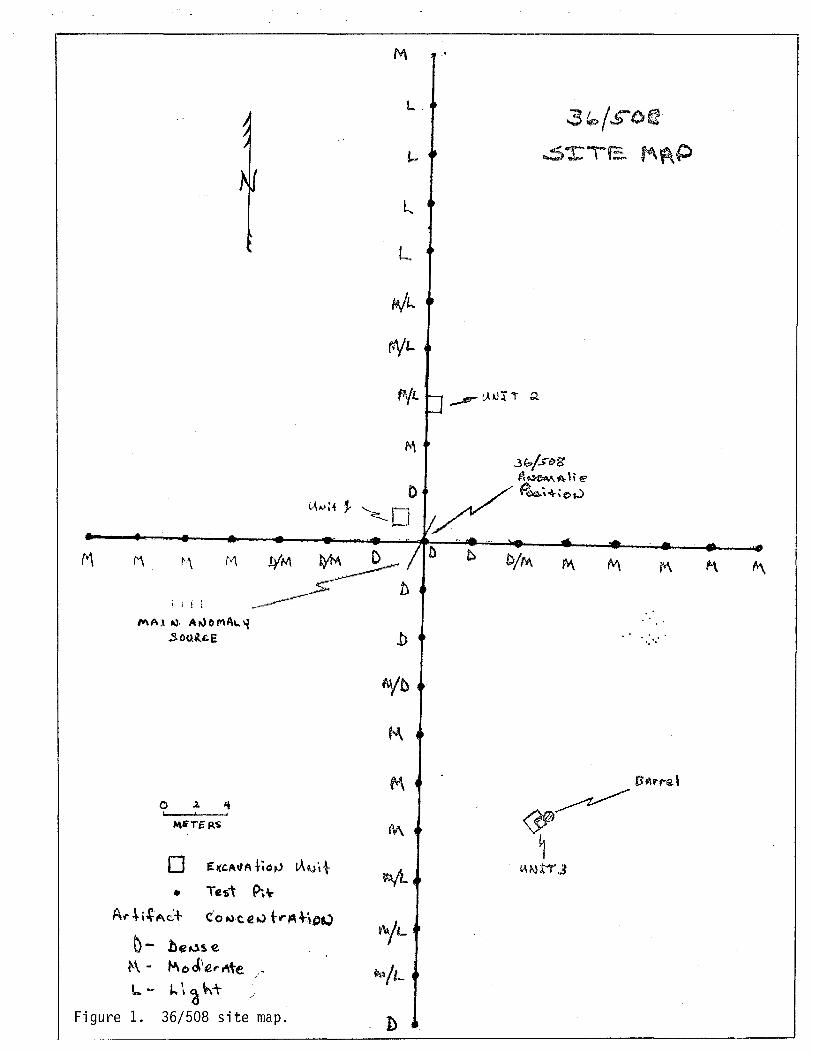
Site 36/508
Site 36/508, located within the turning basin in 18 feet of water (see EG&G Anomalies Location Map), was previously identified as potentially containing in ~it~ deposits of 18th and 19th century cultural materials. Intrusive modern debris was not encountered in the initial testing conducted at 36/508. Instead, a rich deposit of well preserved ceramics, glass, metal and organics was found. This was in contrast to two similar artifact concentration sites, 40/711 and 40/707. Testing of these two areas of cultural material deposition indicated obvious modern intrusive debris thereby negating NRHP eligibility. Owing to the seemingly intact nature of 36/508 an intensive testing phase was instituted.
The investigation was initiated with the placement of grid lines along the North-South and East-West axis of the site. Both the 60 meter North-South and the 42 meter East-West grid were centrally positioned on the anomaly location. Three test units were excavated on the site. Their locations, presented in Figure 1 [36/508 Site Map], correspond to the center of the dense concentration, the northern edge of the concentration, and adjacent to an encountered wooden cask. It was attempted to excavate by means of an airlift only a quarter section of the one-meter units. However, the slumping nature of the sediments required that a larger area, approximately one square meter, be excavated for Units 1 and 2 in order to reach the bottom depths of the cultural deposit. Even so, slumping was a major problem during excavation and caution had to be exercised while airlifting to insure that material from the slumping sides of upper levels did not intrude into lower levels.
The test units were excavated in ten centimeter units employing a four inch "PVC" pipe airlift. Powered by an on-board vessel compressor, the effluent end of the airlift was attached to a 1 by 1.5 meter screen, which floated on the surface adjacent to the project vessel. The airlift operator collected all observed significant artifacts from each level. Additionally, all sediments from each level were screened through the floats'
M
i , i l
MAl -.), A,.)OMAI..~
.$00,,-,11.£
o ..l. " I I •
(,\A.·a "
o ~l{C.A"A t,c)~ lA..,i+
• Te1)1 Pt\ A"'~i~AC+ . c'o~,eeu trAH,,-.)
~ - be")'s e. t-\ - koJ'·€ ... ~te "
/
L'- "'\~h:t /
Figure 1. 36/508 site map.
M
L,
L..
L
MIl-.
MI'-
'YL
,.\
C
.,
~t,A •• r:ri ~
b C/f'l\
::;~/S'O(t
..s"rTE. M¥\P
M M r<\
' ..
OLD SCHOONER CHANNEL, CHRISTIANSTED, ST. CROIX MARINE ARCHAEOLOGICAL SURVEY - JULY/AUGUST 1988
PAGE 39 quarter-inch hardware cloth (screen). A surface observer carefully monitored screening operations and retrieved from each level all screen-collected artifacts. Artifacts were then placed in bags labeled with test unit and level designations.
Artifacts encountered from Test Units 1 and 2, presented in Table 11 (36/508 - Artifact Provenience Table), consisted of ceramic vessel and pipe fragments, bottle, goblet and possibly window glass fragments, bone, wood, brick, coal, slag, ballast stone, iron fasteners, sheet metal fragments from cans or pots, and owing to severe corrosion or concretion, numerous metal fragments of undetermined identity. The finds represent a temporal range of late 18th century to the present. This is consistent with the temporal range of artifacts encountered during the previous initial testing phase. However, while initial testing indicated an intact and stratigraphically undisturbed cultural deposit, methodical excavation revealed the opposite. Finds from several levels are the basis for this conclusion. A modern, green glass bottle fragment, similar to a "Seven Up" bottle, was found in Level 4 of Unit 1 in association with a fragment of Finger Painted Annular ware. Although the ware type, Creamware, Pearl ware, or Whiteware, was undetermined, all would date prior to the glass fragment, circa 1780-1890 (Nicholson, 1979). This also appears to be the case with Level 6. An obviously modern, amber glass bottle fragment similar to common modern amber beer bottle was found in association with Annular ware, lead glazed ceramic fragments, case bottle fragments, and kaolin pipe fragments. Finds from Unit 2 also argue for a disturbed deposit. A modern, clear glass bottle fragment was recovered in Level 2 along with a late-18th or early-19th century, olive~ifreen glass bottle base, a fragment of blue tin-enamel ware, and a kaolin pipe bowl which, because of its shape, appears to date to the 19th century.
While transitting the site during assessment of its horizontal spatial extent, the base of a barrel with a late-18th or early-19th century context was encountered. Noticed by its upper, toredo-eaten staves protruding from bottom sediments, hand fanning revealed possible in ~ii~ artifacts and it was decided to excavate the potentially significant feature with the airlift and screen the sediments. Excavation revealed that only the base of the barrel remained. The last ten centimeters of the barrel were filled with a small, I-to-2 inch, water-worn, black cobble apparently used to help sink the cask. Atop the cobbles were the remains of two wine bottles, which appear to date to the late-18th or early-19th century (Hubbard, 1981). The cobbles appeared

OLD SCHOONER CHANNEL, CHRISTIANSTED, ST. CROIX MARINE ARCHAEOLOGICAL SURVEY - JULY/AUGUST 1988
PAGE 40
Table 11. Site 36/508 - Artifact provenience.
UNIT 1 LEVEL 1 0-10 cm
No Artifacts
LEVEL 2 10-20 cm 1 green glass bottle fragment, 2 piece mold 3 olive green glass bottle fragments 2 undecorated whiteware fragments 1 blue transfer print fragment (ware type?) 1 amber glass bottle fragment (modern/recent) 1 annular ware rim fragment (ware type ?) 1 pearl ware base fragment with partial makers mark 1 yellow brick fragment 5 bone fragments 1 slag 11 Metal fastenersl concreted 1 metal strap 1 coal 11 sheet metal fragments 1 tin can fragment 1 lead fragment
LEVEL 3 1 3 1 1 1 2 4 3 3 1 1
LEVEL 4 1 1 1 1 1 3 3 4 4 3
20':'30 cm olive green glass case bottle fragment olive green glass bottle fragment red paste ceramic fragment undecorated whiteware fragment embossed tin can base/lid coal metal fastenersl concreted sheet metal fragments metal strap fragments wood fragment ri b bone (beef)
30-40 cm undecorated whiteware mug fragment finger painted annular ware (ware type?) green glass bottle fragment (modern/recent) water rounded volcanic ballast stone yellow brick fragment coal metal strap fragments sheet metal fragments sheet metal fragments bone

OLD SCHOONER CHANNEL~ CHRISTIANSTED~ ST. CROIX MARINE ARCHAEOLOGICAL SURVEY - JULY/AUGUST 1988
PAGE 41 LEVEL 5 40-50 cm
1 wooden block key 1 non-descript ceramic fragment (ware type?) 1 olive green glass fragment 1 wooden knife/fork handle 2 bone fragments 1 yellow brick fragment 1 sheet metal fragment 1 hand-hewn log, 6 inches diameter, length 2 feet +
LEVEL 6 50-60 cm 1 olive green glass bottle base 1 clear glass case bottle fragment 4 olive green glass bottle fragments 1 green lead glazed bowl fragment decorated with brown lines 1 green lead glazed ceramic fragment 3 kaolin pipe stem fragments 1 annular ware (ware type?) 1 undecorated whiteware fragment 1 amber bottle fragment (modern/recent) 1 coal 1 slag 5 bone 8 metal fasteners, concreted 1 chain link 4 sheet metal fragments 4 yellow brick fragments
LEVEL 7 60-70 cm Sterile
LEVEL 1 0-10 cm 1 iron strap hinge
LEVEL 2 10-20 cm
UNIT 2
1 blue tin enameled plate/bowl fragment 1 olive green glass bottle base (late 18th century)S 1 clear glass bottle fragment (modern/recent) 1 undecorated whiteware fragment 1 kaolin pipe bowl with a hand in relief and "pipe" 2 bone 1 mental strap fragment 3 undetermined metal fragments
K/evek 3 20-30 cm 3 green lead glazed bowl fragments 2 kaolin pipe stem fragments 1 clear goblet/wine glass stem fragment 1 wood fragment 1 bone
imprint
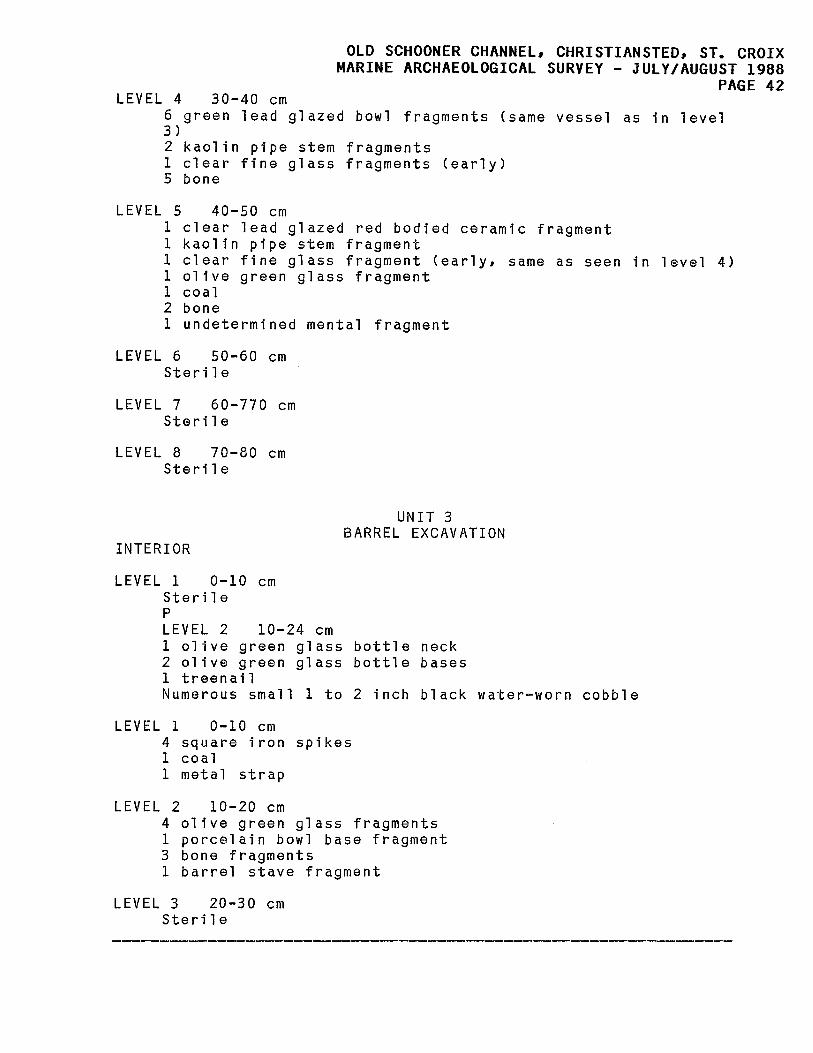
OLD SCHOONER CHANNEL, CHRISTIANSTED, ST. CROIX MARINE ARCHAEOLOGICAL SURVEY - JULY/AUGUST 1988
PAGE 42 LEVEL 4 30-40 cm
6 green 1 ead gl azed bowl fragments (same vessel as in 1 evel 3 ) 2 kaolin pipe stem fragments 1 clear fine glass fragments (early) 5 bone
40-50 cm LEVEL 5 1 1 1 1 1 2 1
clear lead glazed red bodied ceramic fragment kaolin pipe stem fragment clear fine glass fragment (early, same as seen in olive green glass fragment coal bone undetermined mental fragment
LEVEL 6 50-60 cm Sterile
LEVEL 7 60-770 cm Sterile
LEVEL 8 70-80 cm Sterile
INTERIOR
LEVEL 1 0-10 cm Sterile p LEVEL 2 10-24 cm
UNIT 3 BARREL EXCAVATION
1 olive green glass bottle neck 2 olive green glass bottle bases 1 treenail Numerous small 1 to 2 inch black water-worn cobble
LEVEL 1 0-10 cm 4 square iron spikes 1 coa 1 1 metal strap
LEVEL 2 10-20 cm 4 olive green glass fragments 1 porcelain bowl base fragment 3 bone fragments 1 barrel stave fragment
LEVEL 3 20-30 cm Sterile
level 4)
OLD SCHOONER CHANNEL. CHRISTIANSTED. ST. CROIX MARINE ARCHAEOLOGICAL SURVEY - JULY/AUGUST 1988
PAGE 43 to spill out one side of the eroded barrel base and it was decided to excavate a quarter-meter unit at this location. The excavation recovered additional small black cobbles and glass fragments possibly from the wine bottles found in the cask interior. Other recovered artifacts included square spikes, coal, bone, and a porcelain bowl base fragment (Table 11 [36/508 -Artifact Provenience Table]).
The barrel is composed of 20 staves whose tallest has a remaining height of 24 cm. The staves range in width from 6.5 cm to 11 cm and all have a thickness of 2 cm. The base of the barrel is composed of 5 staves whose width ranges from 9.5 cm to 12 cm for a total basal diameter of 53 cm. The barrel's excavation revealed it to have a "V" croze. The "V" croze, the notch where the bottom staves fit into the side staves, indicates that it was used as a dry-goods container rather than a liquid container which would have required a square croze (Shel i Smith, 1988, per. comm.). Wooden withe, used to hold the side staves together, is present along the exterior base directly opposite the interior croze.
In addition to the three airlifted test units, a series of hand fanned tests were placed at three meter intervals along the grid lines in order to assist in determining the spatial and compositional aspects of the site. The density of artifacts was the main characteristic recorded for these tests. Density, defined as dense (D), moderate (M), and light (L) was a comparative reference to the dense concentration of artifacts located a the center of the site. A hand fanned test with an artifact concentration dense as that noted at the anomaly center received a "0," a test that revealed a concentration of approximately half of that realized at the site center received an "M," and those tests that revealed few if any artifacts received the label "L" (Figure 1 [36/508 Site Map]).
By the employment of this method it is apparent that the dense, central concentration covers an area approximately 12 meters north and south by 9 meters east and west. To the north the artifact density becomes extremely light while to the east and west a moderate amount of artifact density is encountered. The area to the south is marked by a moderate artifact density. However, 30 meters to the south is located another artifact concentration similar in density to that of the main concentration. In addition to the determination of the sites horizontal composition, plastic was found in association with red roof tile at 40 cm BD in a test pit 22 meters north of Unit 2. This evidence further argues that the cultural deposit is disturbed.

OLD SCHOONER CHANNEL, CHRISTIANSTED, ST. CROIX MARINE ARCHAEOLOGICAL SURVEY - JULY/AUGUST 1988
PAGE 44
6.2. Site Clusters 20/690, 20/692, 20/693
The cluster of anomalies, 20/690, 20/692, and 20/693 is situated outside the west edge of the mouth of the proposed Schooner Channel adjacent to Round Reef. They represent vessel components from one or more shipwrecks. Initial investigations identified a possible chain-plate, a single ballast pile, assorted metal objects, and a portion of intact hull. The subsequent Phase II investigation has revealed ballast piles which represent three shipwrecks, perhaps four, and potentially many others. The current investigation was instituted by a visual survey that encompassed a larger area than previously surveyed. A single grid line was placed arbitrarily through roughly the center of the site beginning at the northernmost identified ballast pile and ending adjacent 20/693 (Figure 2 [20/693 Site MapJ). The grid line was placed in order to accurately map the area relative to the three known anomaly positions.
The intensive survey and mapping identified three concentrated and well-defined ballast piles which appear to represent three separate shipwrecks. These are located at the northern end of the site area. Two of the ballast piles are composed of two sections of ballast. This probably represents ballasting arrangements on the two respective vessels and/or may reflect the location of a bulkhead. The northernmost of the two is composed of sections separated by a 4-meter interval. Both sections are approximately I-meter high, and are completely flat on top. The smaller section is 4 m by 5 m and the larger is 4.5 m by 9 m. A characteristic unseen on the other ballast concentrations, the complete flatness, possibly indicates an organized ballasting of the vessel. The next ballast pile south is 16 m by 6 m. Its westernmost two thirds is heavily concentrated while the easternmost third is only oneor-two ballast stones deep.
The next ballast pile south is a two-sectioned pile Slmllar to the flat-topped northernmost pile. It is the largest of the ballast concentrations, its smaller section 8 m by 8 m, its larger section 18 m by 7 m. The eastern edge of this pile is 62 feet from the western edge of the proposed channel boundary and is the closest intact pile to Anomaly 20/690. The larger section has a heavier concentration on its northwest quarter and both this concentrated area and the smaller section have a height of 1.3 m. The western edge of the smaller section appeared to have been disturbed by digging. Adjacent to this apparent disturbance a test trench was excavated (Figure 2 [Site MapJ. The trench was approximately 1 m wide and was

----~~ ~-<;.·-r
. ,
,. ,;.
c.. ~~ tJ\t.)~ \.( ~\11>.~'1')
+ '.
'" -.'
o a. " ,l
M~Tflli$
G - ~~, P'I'T
OLD SCHOONER CHANNEL, CHRISTIANSTED, ST. CROIX MARINE ARCHAEOLOGICAL SURVEY - JULY/AUGUST 1988
PAGE 45
~\
n
1110
IS'"
\0
.5 Gr. \-\ t: ..j ~ \... /'<\
II / 3 -~Ie....$\ p~O~$
.1 .. ,
CJ ... ~~~~, • ..., tJ..t..}'l+
_ .. - - ...... ------..
Figure 2. 20/693 site map.

OLD SCHOONER CHANNEL, CHRISTIANSTED, ST. CROIX MARINE ARCHAEOLOGICAL SURVEY - JULY/AUGUST 1988
PAGE 46 excavated to near center of the concentration. The removal of the ballast stones revealed only two artifacts, a painted fragment of black rubber similar to inflatableraft material and the fragmented remains of a wine bottle. The rubber fragment was located near the top of the ballast pile under one course of stone and is thought to be a modern intrusion. The wine bottle fragments, on the other hand, were located at the base of the pile under numerous layers of stone, and are believed to represent in ~~ material. The fragments include the base, the rim and applied lip, and various body fragments. Because of the fragmented nature of the bottle it is difficult to determine the exact shape, but the base and lip appear to represent an 18th century bottle shape and type (Hubbard, 1981; Noel Hume, 1983:60-71).
The excavation of the test trench revealed an absence of hull timbers. Since only a small area of ballast was removed, additional hull timbers mayor may not exist under the unexamined remainder of the ballast pile. However, the trench did show that the ballast pile rested on a bare limestone shelf as it appears do all the major ballast concentrations. And while unsubstantiated, the lack of hull in the test trench may be a reflection on the preservation properties of the shelf area. An absence of fasteners was also noted. It is unclear that even with the disintegration of the hull, why evidence of fasteners was not encountered.
A small area of ballast concentration surrounds Anomaly 20/690. It covers an area approximately 4 m in diameter and is only one end sometimes two ballast stones deep. Two other ballast piles of similar concentration are located to the west of 20/692 and 20/693, 4 m and 15 m in diameter respectively. it must be mentioned that ballast is, for the most partl scattered over the entire site and the scatter blends from one concentration to the next. The ballast is water-worn stone and is generally from 20 cm to 40 cm in diameter. However, several stones approximately 80 to 100 cm were noted scattered randomly over the site.
Other aspects that were noted during the survey was a lack of remaining ground tackle or ordnance. The shallowness of the area would seemingly allow their easy retrieval if they had indeed been present during sinking. While this was probably the case, a small section of the end of an iron anchor stock was located. The curved end, 60 cm in length, which terminates in a ball, is located on the far western end of the trenched ballast pile. The small fragment does not allow for any temporal conclusions as it could date as early as the end of the 16th century and as

OLD SCHOONER CHANNEL, CHRISTIANSTED, ST. CROIX MARINE ARCHAEOLOGICAL SURVEY - JULY/AUGUST 1988
PAGE 47 late as the early~20th century (Upham, 1983), but its presence may indicate a use as ballast. Small fragments of copper sheathing are scattered over the entire area. They appear to be more numerous just west of the trenched ballast pile.
Intensive metal detection was conducted on the surrounding areas of all three anomaly locations. Findings indicate that Anomaly 20/692 is an isolated object. The total excavation of it revealed it to be a 5 foot iron gudgeon with one missing strap. A gudgeon is a metal clamp bolted to the stern post. Pintles on the rudder fit into the corresponding holes on the gudgeons thereby hanging the rudder to the stern-post. The space between the straps, which would have accommodated the stern-post is 9 inches wide. The straps are 4 inches high and 1.7 inches thick. The pintle hole is 2 inches in diameter. Several small fragments of wood were present when the gudgeon was excavated. Perhaps the remains of a segment of the sternpost, they were too small and eroded to discern any useful data. They did not retain any fasteners or evidence of sheathing. Although concreted, the one remaining gudgeon strap has three protrusions, 6, 11, and 15 inches from the strap end. These probably represent through-bolts that held the gudgeon in position.
Besides showing that Anomaly 20/692 is an isolated find, the metal detection also revealed that Anomaly 20/690 is composed of more than the two metal objects that were identified during the initial survey. In fact, 20/690 is composed of numerous iron objects that cover an area extending northward from the central anomaly location and towards the proposed channel edge. What was initially defined as the positioned source of the anomaly is a 10 foot section of heavily concreted angle iron (Figure 2 [Site Map]). Just to the north is a similar shaped piece of iron that protrudes perpendicularly 2 feet from the reef. To the north of this piece is an Lshaped segment of iron that mayor may not be a ship's knee. Again, to the north is what is tentatively identified as a chain-plate (Figure 3 [Chain-Plate]). A dead-eye, which is thought to have been positioned in the metal ring, is eroded away. Positioned approximately 26 feet from the west edge of the proposed channel and buried approximately 15 cm, is a 16 inch square section of copper sheathing. It has sheathing nail holes along its edges. Its small size may be an indication that it is a patch and not a regular sheet (Kevin Foster, 1988, pers. comm.). The sheathing is the nearest wreck feature to the proposed channel and additional metal detection survey revealed no other wreck elements in or adjacent to the channel.

OLD SCHOONER CHANNEL. CHRISTIANSTED. ST. CROIX MARINE ARCHAEOLOGICAL SURVEY - JULY/AUGUST 1988
PAGE 48
//'~;--~\ .-.t ___________ ;
/ \ -----'--_.
CHAIIJ PLATE
c;. 1.0 JO , . .
Figure 3. Chain plate.

OLD SCHOONER CHANNEL, CHRISTIANSTED, ST. CROIX MARINE ARCHAEOLOGICAL SURVEY - JULY/AUGUST 1988
PAGE 49 The third anomaly within the wreck cluster identified dur-ing the previous survey is 20/693. Initially located by the presence of a concreted metal knob protruding from the sand, excavations revealed the "knob" to be a drift bolt attached to a ship's hull. The Phase II investigation of the site began with the placement of a grid system aligned slightly off the North/South and East/West axis and with the intersection of the lines positioned at the drift bolt. The East/West grid line was aligned so that it intersected the proposed western channel edge at a perpendicular to allow and insure an accurate delineation of the site relative to the channel edge.
Test probes, approximately 40 cm in diameter, were airlifted along the grid lines every meter (Figure 2 [Site Map]). The type and depth of encountered cultural material was recorded for each probe (Table 12 [Site 20/693 -Test Pit Artifact Provenience Table]). In this manner it was determined that the hull-section remains cover an area from Test Probe G to D along the North/South axis and from Test Probe 5 to 7 along the East/West axis, an area 3 m by 2 m. The probing also revealed the site boundaries to extend only from Test Probe G to Test Probe C along the North/South axis, a distance of 4 m. The East/West boundaries extend from Test Probe 3 to Test Probe 22 along the East West axis, a distance of 19 m. Material is concentrated at and adjacent to the hull section and steadily decreases in amount and depth as one approaches the proposed channel edge to the East. Encountered cultural material was predominantly small ballast stone and iron fasteners. Glass, ceramic and other specific diagnostic materials, e.g., temporal or origin, were not encountered. This apparent paucity of diagnostic cultural material is not a reflection of the testing method, as the unit excavations prove, but rather is an indication of site characteristics.
Two square-meter units were excavated atop the center of the hull section (Figure 2 [Site Map]). An airlift was employed and owing to the surface wave action, a floating screen platform was not utilized. Instead a mesh bag was tied to the effluent end of the lift. While this necessitated constant emptying of the bag, it afforded maximum artifact retrieval. All bag contents were inspected on the deck of the surface vessel.
The excavation of the units exposed a run of outer-hull planking composed of 5 hull planks and the remains of 6 frames (Figure 4 [Hull Section]). The planks range from 7-to-9 inches in width and are 2.5 inches thick. They are worm eaten, spongy and easily damaged, but are in relatively good condition when compared to the frames. A total of 7 frames are present. The frames are

o
OLD SCHOONER CHANNEL, CHRISTIANSTED, ST. CROIX MARINE ARCHAEOLOGICAL SURVEY - JULY/AUGUST 1988
PAGE 50
o 0·0
0
0
~ 0
0 K
(JI
j .
s:: 0
.r-+> U QJ en r-r-
~ :::5 :c
1 . "'"
QJ
~~~ s... ~ Q :::5
~ :~ t:n
.r-l.L..
a:~1 cJ ......
. _-._- ------ --
Table 12.
~l_£ll ~~ 1 2 3 5 6 7 8 9 10 11 12 13 14
15 16 17 18 19
20
21 22 23 24
A B C
o E F G H I J K L M
OLD SCHOONER CHANNEL, CHRISTIANSTED, ST. CROIX MARINE ARCHAEOLOGICAL SURVEY - JULY/AUGUST 1988
PAGE 51
Site 20/693 - Test pit artifact provenience.
Sterile Sterile 1 small ballast stone at 47 cm BD 2 small eroded plank fragments at 47 Hull Section - Test Excavation Unit 1 2 hull planksl 1 ballast stone 55 cm BD 2 large drift bolts 30 cm BD Material at 40 cm - probed only Material at 30 cm - probed only Material at 25 cm - probed only 3 large drift bolts several ballast stone 35 cm BD Material at 40 cm - probed only 3 ballast stone 1 drift bolt with wood frag-ment 35 cm BD Material at 40 cm - probed only Sterile to 40 cm BD No material to 50 cm - probed only No material to 50 cm - probed only 2 small wood fragments at 30 cm BD, one burnt, one with square fastener hole 2 small ballast stone, 1 small burnt wood fragment 35 cm BD Sterile to 50 cm BD 1 small 7 cm ballast stone 30 cm BD Sterile to 50 cm BD Sterile to 60 cm BD
Sterile to 65 cm BD Sterile to 60 cm BD 1 yellow hand made brick, 1 large ballast stone, 15 inch iron spike 24 cm BD Hull Section - Test Excavation Unit 2 Hull Section - Test Excavation Unit 1 and 2 Hull Section - Test Excavation Unit 1 2 foot drift bolt on edge of hull section 40 cm BD Sterile 40 45 cm BD Sterile - Hardpan reef at 40 cm BD Did not test Sterile - Hardpan reef at 30 cm BD Did not test Sterile - Hardpan at 35 cm BD
------------------------------------------------------------BD = Below Datum/Below the surface of bottom sediments
-----------------------------------------------------------------

OLD SCHOONER CHANNEL, CHRISTIANSTED, ST. CROIX MARINE ARCHAEOLOGICAL SURVEY - JULY/AUGUST 1988
PAGE 52 most intact along the east wall of the units. Howeverl they are all badly deteriorated, especially as one goes from their base against the hull planks upwards. Their extremely deteriorated condition made an accurate determination of moulding and siding difficult at best. A possible scenario for the contrasting conditions of planks and frames may have seen the planking, which lay directly on the sea floor, being buried first while the frames, projecting into the non-protective water column, being subsequently covered at a later date during which time their deterioration progressed past that of the planks.
The remaining sided dimensions of the frames range from 5-to-8 inches, but the original dimension of two of the frames may have been as much as 10 or 11 inches. This projection is based on fastener locations. The largest remaining moulded dimension is 10 inches. The frames cross the planks at a slight angle and appear to have little or no longitudinal curve. The deteriorated condition of the frames and the small portion of hull section does not readily allow for a determination of the frame type and space, or the section's location on the vessel. It does appear that the frames are fairly large and their slight cant may be an indication of the hull section originating from the bow or stern. They appear to be predominately fastened with treenails as opposed to iron spikes and drift bolts. Though speculative, the intact 2 foot drift that is present at the extreme southern end of the hull section may be indicative of a deck shelf, knee, or internal stringer. A glimpse of the outer side of the planks in this area revealed no evidence of sheathing or hull covering.
As mentioned, the fasteners are predominately I-inch diameter treenails although several 1/2-inch square iron spikes are present. No apparent pattern was noticed except at the butted ends of two planks. These have each been fastened to a single frame with 3 square iron spikes and 1 treenail (Figure 4 [Hull Section drawing]). Remains of the frame are only present at this location because of concretions caused by the spikes. The fasteners allow for a projection of frames across the planks and it appears that all cross the planks. No frame-to-frame drifts were noted in ~ii~. However, a drift bolt was present lying atop the planks in the Southwest corner. Its positioned angle, perpendicular to the frames, would be correct for an edge fastener. This is only tentative speculation as frames in this area were completely eroded.
Besides fasteners and wood, only two artifacts were encountered during the excavation of the hull section. One, a fragment of what appears to be a modern, molded, milk glass cold-cream jar (Ponds), was found in the north-

OLD SCHOONER CHANNEL, CHRISTIANSTED, ST. CROIX MARINE ARCHAEOLOGICAL SURVEY - JULY/AUGUST 1988
PAGE 53 ern unit 25 cm below the surface sediments. The second, a kaolin pipe stem fragment was found lying atop the hull. The stem has the letters " ••• ITE" on one side and "GLAS ••• " on the other. The impressed lettering more than likely stands for "White" and "Glasgow." William White was a manufacturer of clay tobacco pipes in Glasgow, Scotland, from 1805-1955 (Pfeiffer, 1983; Wilson, 1971). Because no other artifacts were encountered during the excavation of the hull (even ballast stones were not encountered), and the fact that the cold-cream jar was in sterile overburden, 18 cm above the hull, it is felt that the jar probably represents an unassociated artifact. However, the pipe stem, which we feel is in ~i~, being directly against the hull, has a possible date range of @ 145 years and i~ little help in determining a temporal context for the vessel remains.
6.3. Conclusions
The initial submerged cultural resources survey of the Old Schooner Channel, St. Croix, U.S. Virgin Islands, resulted in the location and investigation of twenty anomalies. Of the twenty anomalies investigated, four, 26/508 located in the turning basin and 20/690, 20/692, and 20/693 which form a cluster at the mouth of the proposed channel adjacent Round Reef, were determined to be potentially archaeologically and historically significant relative to National Register of Historic Places (NRHP) nomination eligibility. Further investigation of these sites was recommended and subsequently conducted in order to assess their significance relative to NRHP eligibility criteria. Requirements for eligibility state that:
The quality of significance in American history, architecture, archaeology, engineering, or culture, and possess integrity of location, design, setting, materials, workmanship, feeling, and association. To be considered significant the site (shipwrecks are considered archaeological sites) must meet one or more of the four National Register criteria:
A. be associated with events that have made a significant contribution to the broad patterns of our history; or
B. be associated with the lives of persons significant in our past; or

OLD SCHOONER CHANNEL. CHRISTIANSTED. ST. CROIX MARINE ARCHAEOLOGICAL SURVEY - JULY/AUGUST 1988
PAGE 54 C. embody the distinctive characteristics of a type, period, or method of construction, or that represent the work of a master, or that possess high artistic values, or that represent a significant and distinguishable entity whose components may lack individual distinction; or
O. have yielded, or may be likely to yield, information important in prehistory or history.
The investigation at 36/508 indicates that the integrity of the cultural deposit has been compromised by intrusive modern material. This in itself is enough to state that the site is not eligible for NRHP nomination. However, as illustrated by the preservation of the base of the barrel, isolated features appear to be intact. While this feature, its association and/or context, in all probability represents an isolated occurrence it does illustrate that the site retains and can yield information that may be archaeologically important. This is substantiated by what appears to be horizontal clustering of cultural materials. Though not to be construed as a fulfillment of criterion 0, it does strongly argue for the avoidance of the site if at all possible. It should be mentioned that the site is at least 18 feet deep, the maximum depth of proposed dredging, and should pose no problem for avoidance.
The site represented by the cluster of anomalies 20/690, 20/692, and 20/693 has been shown to be composed of the scattered remains of multiple shipwrecks. It appears that the ballast piles on the hard-shelf fringes of Round Reef are the central locations for the wrecks and that the materials identified as anomalies are scattered elements of those wrecks. We know through historical documentation that numerous wrecks occurred in and around the project area as early as the first quarter of the 18th century. Of these, we know that many were wrecked at the entrance to the harbor. This is not surprising as even in modern times the channel entrances are noted as "tortuous and intricate" (U.S. Coast and Geodetic Survey, 1939). However, the historical wreck information is not specific enough as to exact location to project it into the understanding of the wreck cluster. Conversely, not enough archaeological information was compiled to cross reference historical information.
We do know through the single test trench excavated into the ballast pile adjacent 20/690 that it has an 18th century context. In addition, both the sheathing at 20/690 and the pipe stem at 20/693, while possibly originating from separate vessels, indicate a 19th or 20th century context. Excavations have also revealed that intact hull is present at least off the reef shelf, and that although

OLD SCHOONER CHANNEL, CHRISTIANSTED, ST. CROIX MARINE ARCHAEOLOGICAL SURVEY - JULY/AUGUST 1988
PAGE 55 artifacts are scarce, in ~l!M' the sites' potential abil-ity to yield important archaeological and historical data is enough to fulfill criterion "0" and thus makes the site theoretically eligible for NRHP nomination. Since the site is situated well outside the proposed channel, it is recommended that determination of eligibility be made eventually by the State Historic Preservation Office. It is additionally recommended that dredging in this area be carefully controlled as to anchor or mooring placement, and dredge location relative to established channel boundaries. Furthermore, the scattered and buried nature of the site creates the potential for undiscovered wreck components. Because of these reasons it is recommended that a qualified archaeological observer monitor dredging activities in this area. This would include both the monitoring of any dredge or barge mooring placement, dredging itself and dredge spoil discharge in the spoil areas.

OLD SCHOONER CHANNEL MARINE ARCHAEOLOGY SURVEY
REFERENCES
Barbot, J., 1732. Description of the coast of North and South Guinea •••• London.
Bergsoe, A. (ed.), 1853. Den Danske stats statistik. Vol. 4. Copenhagen.
Caron, A., 1982. Inventory of French documents pertaining to the U.S. Virgin Islands 1629-1737. Dept. Conserve & Cult. Aff., St. Thomas, V I.
Caron, A. and Highfiel d, A. I 1978. Jean-Bapti ste DuTertre on the French in St. Croix and the Virgin Islands. Dept. Conservo & Cult. Aff., St. Thomas, VI.
DeJongh & Associates and URS Madigan-Praeger, 1983. Christiansted cruise ship facility master plan-feasibility study. St. Thomas, VI and New York, NY.
Dookhan, I., 1974. A history of the Virgin Islands of the United States. Epping, Essexl England.
DuBois, J., 1869. Letter to Foreign Office, April 30th. In British Consular despatchesl 1968. London.
Figueredo, A., 1978a. The early European colonization of St. Croix (1621-1642). Jour. V. I. Arch. Soc., No.6.
Figueredo, A., 1978b. The Virgin Islands as an historical frontier between the Tainos and the Caribs. Revista/Review Interamericana, 8:393-399.
Figueredo, A. and Tyson, G., 1985a. Phase 1a and phase 1b report of possible archaeological impact of proposed development on Parcel 64, Est. Mount Welcome, East End Quarter A, District of St. Croix, Virgin Islands of the United States. Prep. for Antilles Enterprises, St. Croix, VI.
Figueredo, A. and Tyson, G. I 1985b. Phase 1a cultural resources survey of Plots 212, 213, 214, 215, 230 and 231a, Est. Golden Rock, Company Quarter, Christiansted jurisdiction, District of St. Croix, Virgin Islands of the United States. Prep. for Antilles Enterprises, St. Croix, VI.
Foster, K., 1988. Personal communication. Maritime historian, Maritime Preservation Group, National Park Service. Washington, DC.
56

Freneau, P., 1779. Account of the Isl and of Santa Cruz. In: Tyson, G. (ed.), Powder, profits and privateers: A documentary history of the Virgin Islands during the era of the American Revolution. Dept. Conserve & Cult. Aff., St. Thomas, VI. Occ. Paper 1977 ••
Green-Pedersen, S., 1971. Dan i sh negro sl ave trade. 19:149-197.
The scope and structure of the Scandinavian Econ. Hist. Rev.,
Haagensen, R., 1758. Beskrivelse over Eylandet St. Croix [America] Vestindien. Copenhagen.
Hornby, 0., 1985. The town of Christiansted in Danish times. Lecture given at Government House, Christiansted, VI, May 26th.
Hubbard, R., 1981. Eighteenth and nineteenth century bottles and their identification. Trinidad Naturalist Magazine, 3(8):14-20.
Insular Environments, Inc., 1973. Draft environmental impact statement mari ne sand dredgi ng, Chri sti ansted Harbor, St. Croix, U.S. Virgin Islands. Prep. for V.I. Port Authority, St. Thomas, VI.
Island Resources Foundation, 1978. Environmental impact assessment of proposed modifications to Gallows Bay commercial harbor facilities St. Croix, U.S. Virgin Islands. Prep. for V. I. Port Auth., St. Thomas, VI.
Jennings, J., 1938. Our American tropics. New York, NY.
Johnston, B. and Lundberg, E., 1983. Archaeological survey of the United States Virgin Islands: A preliminary report. Proc. 10th Congr. Study of Pre-Columbian Cultures of the Lesser Antilles. Fort-de-France, Guadeloupe, 25-30 July, 1983.
Lewisohn, F., 1970. St. Croix under seven flags. Hollywood, FL.
Marx, R. and Towle, L, 1971. Shipwrecks of the Virgin Islands (1523-1825). Carib. Res. Inst., St. Thomas, VI.
Mayes, P., 1972. Port Royal, Jamaica: Excavations 1969-70. Jamaica National Trust Commission, Kingston.
Nichols, Mol et al., 1972. Environment, water and sediments of Christiansted Harbor. Carib. Res. Inst., St. Thomas, VI.
57

Nicholson, D., 1979. The dating sites by the analysis of ceramic 1 ands Arch. Soc. I no. 7.
of West Indian historic shards. Jour. Virgin Is-
Noel-Hume, I., 1982. A guide to artifacts of colonial America. Alfred A. Knopf, New York, NY.
Norie & Wilson, 1885. Sailing directions for the West Indies. The Caribbean Islands from Trinidad to Porto Rico. London, UK.
Oldendorp, C., 1770. History of the Mission of the Evangelical Brethren on the Caribbean Islands of St. Thomas, St. Croix, and St. John. English trans1- of 1987 by A. Highfield and V. Barac, Ann Arbor, MI.
Peterson, M., 1969. History under the sea: A handbook for underwater exploration. Smithsonian Institute Press, Washi ngton, DC.
Pfeiffer, M., 1983. W. white pipes from the Foote House pump dump, 10AA96. In: Sudbury, B. (ed.), Historic clay tobacco pipe studies. Vol. 2. Ponca City, OK.
Rainals, H., 1865. Letter to Foreign Office, 25 February. In Foreign Office papers 22/231. Publ ic Record Office, Kew, England.
Rigsarkivet, 1778-1800. St. Croix notorial protokol. In Vestindien Lokal Arkiver.
Royal Danish American Gazette (St. Croix), 1772. Local notices. September 30th.
Smith, S., 1988. Personal communication. Underwater Archaeological Consortium, San Pedro, CA.
Svensson, O. (ed.), 1964. Three towns. Copenhagen.
Ti ppetts-Ab bett-McCa rthy-St ratton, 1958. Maste r plan Ch r i 5-
tiansted Harbor, St. Croix, VI Prep. for Govt. Virgin Islands, St. Thomas, VI.
Turner, M., 1889. Santa Cruz: Report by Consul Turner of St. Thomas. In: U. S. Department of State, Commercial relations of the United States with foreign countries ••• 1887 and 1888. Washington, DC.
Tyson, G., 1978. History and archaeology of Gallows Bay. In: Island Resources Foundation, Environmental impact assessment of proposed modifications to Gallows Bay commercial harbor facilities, St. Croix, U.S.V.I. Prep. for V.I. Port Authority, St. Thomas, VI.
58

Tyson, G., 1983. Register of Virgin Islands shipwrecks (1523-1917). Compiled for the Div. of Archaeology and Historic Preservation. V.I. Planning Office, St. Thomas, VI.
Tyson, G., 1986. Socio-economic history of St. Thomas Harbor. In: St. Thomas Historical Trust, The St. Thomas Harbor: A historical perspective. St. Thomas, VI.
U. S. Coast and Geodetic Survey, 1939. pilot, West Indies: Puerto Rico and Washington, DC.
United States coast the Virgin Islands.
U. S. National Archives, 1825-1831. U. S. consul ar despatches, St. Croix. Dept. of State papers.
Upham, N., 1983. Anchors. Shire Album 110, Shire Pub1- Ltd, Aylesbury, UK.
Vibaek, J., 1966. Dansk Vestindien 1755-1848. In: Brondsted, J. Ced.), Vore gamle tropekolonier. 2nd ed., Fremand, Denrna rk.
Virgin Islands Daily News, 1982. The unsuccessful colonists: The French on St. Croix in the seventeenth century. 50th Anniversary Issue, August 1, St. Thomas, VI.
Virgin Islands, Governor, 1930-1966. Thomas, VI.
Annual reports. St.
Westergaard, W., 1917. The Danish West Indies under company rule (1671-1754), New York, NY.
Willis, J., 1963. The trade between North America and the Danish West Indies 1756-1807, with special reference to St. Croix. Ph.D. dissertation, Columbia Univ., New York, NY.
Wilson, R., 1971. Clay tobacco pipes from Fort Laramie National Site and related locations. Div. Arch. Anthrop., Nat. Park. Serv., Wash i ngton, DC.
Zabriskie, L., 1918. The Virgin Islands of the United States. New York, NY.
59

Anon., 1682. Geometric plan of the Fort on the Island of St. Croix, with the town, harbor and adjacent channels ••
Anon., 1756. Chart of the town and harbor of Christiansted on the Island of St. Croix ••
Anon., 1803. Sketch of Bassend ••
Anon., 1906. Christiansted Harbor. Surveyed by the Schooner Inglof.
Beenfeldt, H., 1815. View of Christiansted. Reprod. in: Eilstrup, P. and Boesgaard, N., Fjernt fra Denmark. Copenhagen, pp.l06-107.
Beenfeldt, H., 1815. View of Christiansted Wharf. Reprod. Siden Saxo Magsin for Dansk Historie, no. 4, 1987.
Fritz, L, 1831. Christiansted from Peter Farm. Reprod. in: Svensson, O. (ed.), Three towns. Copenhagen, pp.56, 1964.
Fritz, L, 1831. Christiansted Wharf looking toward Protestant Cay. Reprod. in: Eilstrup, P. and Boesgaard, N., Fjernt fra Denmark. Copenhagen, pp.120.
Oldendorp, C., 1768. View of Friedensthal from the West. Reprod. in: Bossard, J., (ed.), History of the Mission of the Evangelical Brethren on the Caribbean Islands of St. Thomas, St. Croix and St. John. Translation by A. Highfield and V.Barac, Ann Arbor, MI.
Oxholm, P. , 1778. Chart of the town and harbor of Christiansted, with surrounding neighborhood ••
Oxholm, P., 1794. Map of the Island of St. Croix ••
Parsons, Lt., 1856. Christiansted Harbor ••
Rohde, L., 1815. Harbor of Christiansted, St. Croix ••
Sti bol t, P., 1735. Chri sti ansted Harbor ••
60
APPENDIX - PAGE 61
SCHOONER CHANNEL ~ARINE ARCHAEOLOGICAL SURVEY PROJECT PHOTOGRAPHS
Negative Anomaly
o 20/693 1 20/690 2 " 3 " 4 " 5 It
6 II
7 \I
8 " 9 It
10 It
11 20/693 12 II
13 " 14 11
15 20/690 1 r _0
17 13 19 20 21 22 23 ,.., , L'+
25 26 27 28 29
II
II
20/593 20/693 20/693 20/693 20/693 20/593 20/693
Site Description
Excavation of Units Anchor Stock Fragment Ballast Test Trench Ballast Test Trench Ballast Test Trench Chain Plate Chain Plate Protruding Iron Anomaly Location/Angle Iron Anomaly Location/Angle Iron Anomaly Location/Ballast Pile Hull Excavation Hull Excavation Hull Excavation Hull Excavation Large Ballast Pile Ballast Pile Before Trenching 8 all a s t P i 1 e Aft e r T r eli::': h .; ;; 9 2nd Ballast Pile from North (see Northernmost Ballast Pile Northernmost Ballast Pile Northernmost 8allast Pile ~orthern~ost Ballast Pile Hull Hull H u 11 1--: u 1 1 H u 11 H u 1 1 H u 1 1
flt a p )