Embed Size (px)
Citation preview

OverviewOverview
ISO TC211 The 19100 series of standards Efforts to create standards for representation of
“Essential Climate Variables”
The UNFCCC’s request to ISO to create a Joint Steering Group Involving TC207 and TC211
IEEE-SA SCC 40 (Earth Observations) Created to support GEOSS
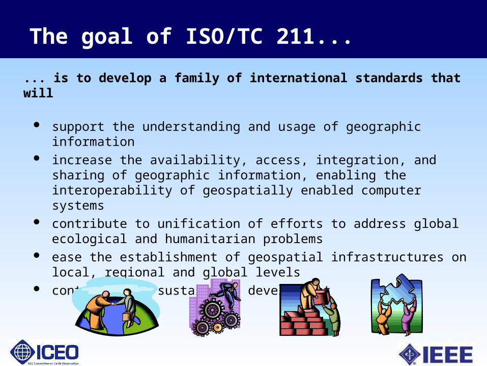
The goal of ISO/TC 211...
... is to develop a family of international standards that will
support the understanding and usage of geographic information increase the availability, access, integration, and sharing of
geographic information, enabling the interoperability of geospatially enabled computer systems
contribute to unification of efforts to address global ecological and humanitarian problems
ease the establishment of geospatial infrastructures on local, regional and global levels
contribute to sustainable development

AG StrategyAG Strategy
WG WG 6 6 Douglas O’BrienDouglas O’Brien
CanadaCanada
WG WG 77Antony CooperAntony Cooper
South AfricaSouth Africa
WG WG 44Morten BorrebækMorten Borrebæk
NorwayNorway
ISO/TC 211 organization
Geospatial Geospatial servicesservices
ImageryImagery InformationInformationcommunitiescommunities
Information Information managementmanagement
Ubiquitous Ubiquitous public accesspublic access
AG OutreachAG Outreach
HMMGHMMG
ChairmanChairmanOlaf ØstensenOlaf Østensen
SecretarySecretaryBjørnhild SæterøyBjørnhild Sæterøy
NorwayNorway
TMGTMG
TF 211/204TF 211/204
WG WG 9 9 Hiroshi ImaiHiroshi Imai
JapanJapan
JAGJAG AGS-PTAGS-PT
WG 10WG 10Sang-Ki HongSang-Ki Hong
KoreaKorea
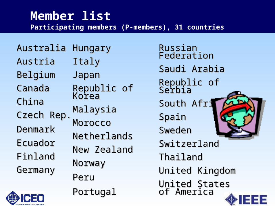
Member listParticipating members (P-members), 31 countries
AustraliaAustralia
AustriaAustria
BelgiumBelgium
CanadaCanada
ChinaChina
Czech Rep.Czech Rep.
DenmarkDenmark
EcuadorEcuador
FinlandFinland
GermanyGermany
HungaryHungary
ItalyItaly
JapanJapan
Republic of KoreaRepublic of Korea
MalaysiaMalaysia
MoroccoMorocco
NetherlandsNetherlands
New ZealandNew Zealand
NorwayNorway
PeruPeru
PortugalPortugal
Russian FederationRussian Federation
Saudi ArabiaSaudi Arabia
Republic of SerbiaRepublic of Serbia
South AfricaSouth Africa
SpainSpain
SwedenSweden
SwitzerlandSwitzerland
ThailandThailand
United KingdomUnited Kingdom
United States of United States of AmericaAmerica

Member listObserving members 30 (25 O-members, 4 corresponding members)
ArgentinaArgentina
Bahrain (corr.)Bahrain (corr.)
Brunei Darussalam Brunei Darussalam (corr.)(corr.)
ColombiaColombia
CroatiaCroatia
CubaCuba
Estonia (corr.)Estonia (corr.)
FranceFrance
GreeceGreece
Hong Kong (corr.)Hong Kong (corr.)
IcelandIceland
IndiaIndia
IndonesiaIndonesia
Isl. Rep. of IranIsl. Rep. of Iran
IrelandIreland
JamaicaJamaica
KenyaKenya
MauritiusMauritius
Oman (corr.)Oman (corr.)
Pakistan Pakistan
PhilippinesPhilippines
PolandPoland
RomaniaRomania
SlovakiaSlovakia
SloveniaSlovenia
TanzaniaTanzania
TurkeyTurkey
UkraineUkraine
UruguayUruguay
ZimbabweZimbabwe
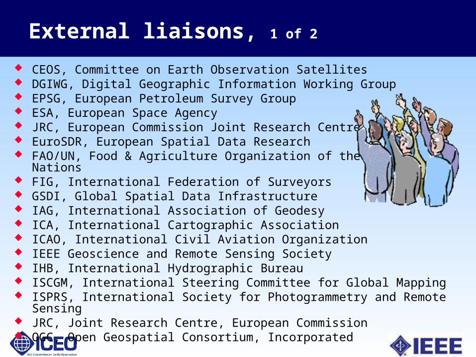
External liaisons, 1 of 2
CEOS, Committee on Earth Observation Satellites DGIWG, Digital Geographic Information Working Group EPSG, European Petroleum Survey Group ESA, European Space Agency JRC, European Commission Joint Research Centre EuroSDR, European Spatial Data Research FAO/UN, Food & Agriculture Organization of the United Nations FIG, International Federation of Surveyors GSDI, Global Spatial Data Infrastructure IAG, International Association of Geodesy ICA, International Cartographic Association ICAO, International Civil Aviation Organization IEEE Geoscience and Remote Sensing Society IHB, International Hydrographic Bureau ISCGM, International Steering Committee for Global Mapping ISPRS, International Society for Photogrammetry and Remote Sensing JRC, Joint Research Centre, European Commission OGC, Open Geospatial Consortium, Incorporated
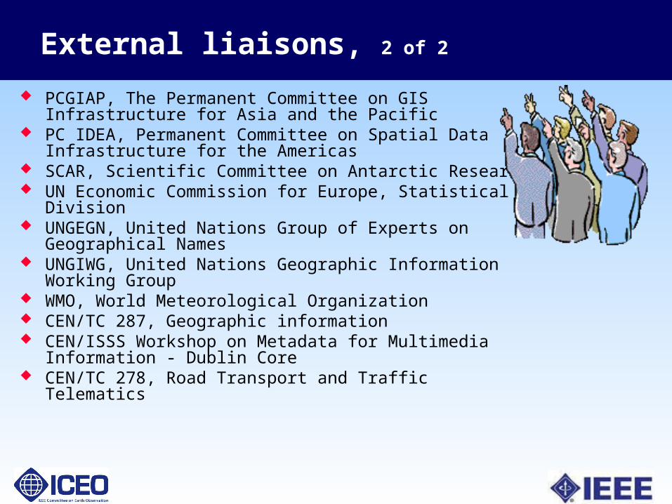
External liaisons, 2 of 2
PCGIAP, The Permanent Committee on GIS Infrastructure for Asia and the Pacific
PC IDEA, Permanent Committee on Spatial Data Infrastructure for the Americas
SCAR, Scientific Committee on Antarctic Research UN Economic Commission for Europe, Statistical Division UNGEGN, United Nations Group of Experts on Geographical
Names UNGIWG, United Nations Geographic Information Working
Group WMO, World Meteorological Organization CEN/TC 287, Geographic information CEN/ISSS Workshop on Metadata for Multimedia Information -
Dublin Core CEN/TC 278, Road Transport and Traffic Telematics
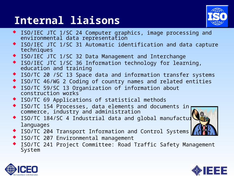
Internal liaisons ISO/IEC JTC 1/SC 24 Computer graphics, image processing and
environmental data representation ISO/IEC JTC 1/SC 31 Automatic identification and data capture techniques ISO/IEC JTC 1/SC 32 Data Management and Interchange ISO/IEC JTC 1/SC 36 Information technology for learning, education and
training ISO/TC 20 /SC 13 Space data and information transfer systems ISO/TC 46/WG 2 Coding of country names and related entities ISO/TC 59/SC 13 Organization of information about construction works ISO/TC 69 Applications of statistical methods ISO/TC 154 Processes, data elements and documents in commerce,
industry and administration ISO/TC 184/SC 4 Industrial data and global manufacturing
languages ISO/TC 204 Transport Information and Control Systems ISO/TC 207 Environmental management ISO/TC 241 Project Committee: Road Traffic Safety Management System
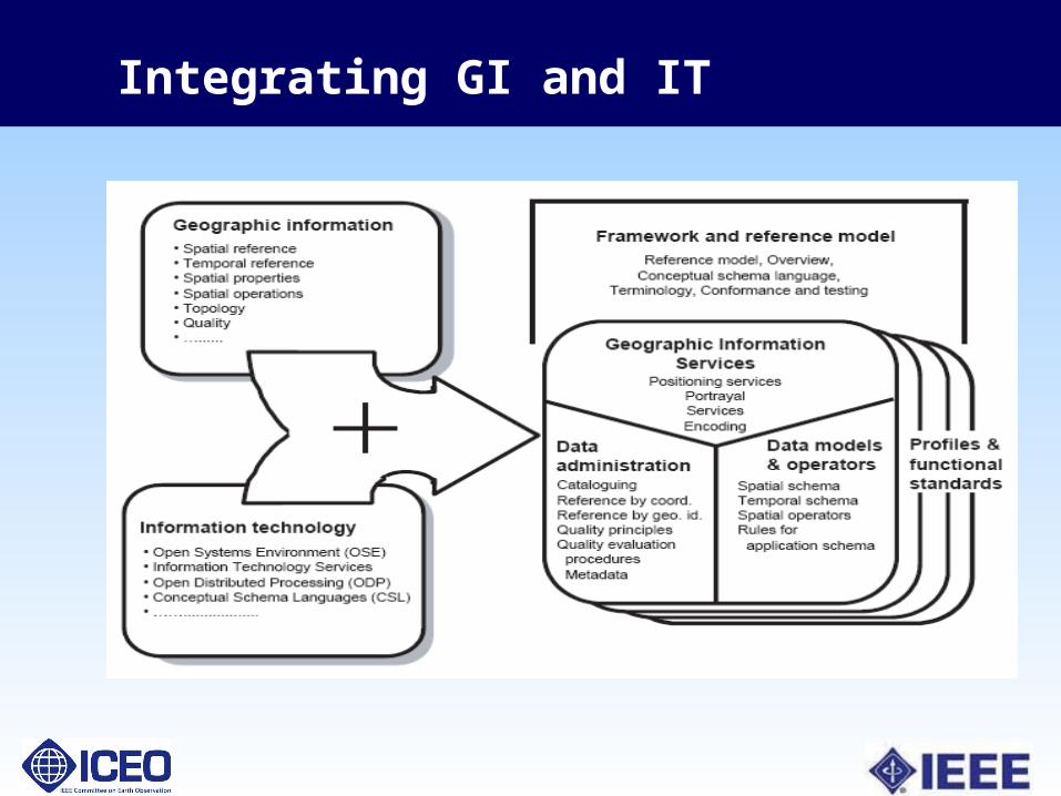
Integrating GI and IT
ISO TC211
19100 series A structured set of standards for information
concerning objects or phenomena with locations relative to the Earth
Specifies methods, tools and services for management of geographic information
Including the definition, acquisition, analysis, access, presentation and transfer of such data
Over 50 projects; 40 have been finalized as ISO standards or technical specifications
Adaptable through use of profiles
Highlights of 191XX Standards
Architectural Reference Model (ISO 19101) Describes computational services to manipulate
geographic information in a distributed processing environment
Presents Enterprise, Informational, Computation, Engineering Viewpoints
General feature model (ISO 19109) Meta-model for developing conceptual models Types, attributes, associations and operations for
“features” (abstractions of real world phenomena), defined in feature catalogs (19110)
Also covers application schema
More 191XX Standards
Metadata (ISO 19115) Widely adopted in earth observation community
Encoding (ISO 19139) XML schemas for describing, validating and exchanging
metadata
19128 (WMS), 19136 (GML), 19142 (WFS) inherited from OGC
Others 19117 – portrayal, 19118 – encoding, 19119 - services Also, standards for DRM, registry management, and quality
measures

IPCC, UNEP, UNFCCC, GTOS and ECVs
The UNEP (United Nations Environment Program) and the WMO (World Meteorological Organization) created the IPCC (Intergovernmental Panel on Climate Change)
To assesses the scientific, technical and socio-economic information necessary to understand the risk of human-induced climate change
GCOS (Global Climate Observing System) was created to ensure that observations and information necessary for addressing climate change are available. Includes GOOS, GTOS, GAW, GCW

Essential Climate Variables
GCOS has identified 47 Essential Climate Variables (ECVs) Determined to be technically and economically
feasible for systematic observation Need to be accurately measured and systematically
monitored Of the 13 Terrestrial ECVs, most are globally
distributed and can be represented as coverages The ECVs encompass many domains and
measurement protocols
UNFCC’s Request to GTOS
In 2006 the UNFCCC (United Nations Framework Convention
on Climate Change) the SBSTA (Subsidiary Body for Scientific
and Technological Advice) called on GTOS to: “assess the status of the development of standards for each of
the essential climate variables in the terrestrial domain”
The UNFAO is working with TC211 to develop standards for the representation one of the terrestrial ECVs – Land Cover
GEO Task CL-06-03: Develop intergovernmental mechanisms for coordinating terrestrial observations needed for climate studies and forecasting.
19144 – Classification Systems
Part 1: Classification system structure Based on discrete coverages and classification
rules maintained in registry At DIS stage
Part 2: Land Cover Classification System FAO/UNEP Land Cover Classification System Conceptual Basis for land cover description and
Registration of Classifiers Did not pass vote to advance to DIS, being revised

LCCS
Provides a scale independent method of classifying land cover
Uses a set of diagnostic criteria to successively refine land cover features
Approach is generic and supports all types of land cover and accommodates all existing classification systems
Goal is to create an absolute level of standardization between different land cover classification systems
ISO Joint Steering Group
ISO will establish Joint Steering Group for ECVs to support the UNFCCC’s mandate The JSG will determine which ISO committee or
liaison organization will create each required standard
Expected to happen at TMB September 2008
It is possible that the JSG will ask bodies like the IEEE for technical advice Leary of undue influence from industry
The Standards Coordinating Committee for Earth Observations (SCC 40)
Created to oversee the development of standards essential to the functioning of GEOSS (Global Earth Observations System of Systems ) Includes standards related to sensor systems,
communications, data processing, data archiving, data searching and access, data portrayal and decision support systems
Type 2 - can sponsor a standards development effort involving multiple IEEE technical societies
Approved by the Standards Board 3/2006

SCC 40
The ICEO has taken a leadership role in facilitating standards and interoperability for GEOSS Current SCC40 membership is 8 volunteers
working on GEOSS-related standards projects IEEE members are also working to support
The ICEO Standards Working Group The GEO Standards and Interoperability Forum The GEOSS Standards Registry The GEO Interoperability Process Pilot Projects

Useful Links
GEO Standards Registry (hosted by IEEE-SA) http://seabass.ieee.org/groups/geoss/
SCC 40 Homepage http://grouper.ieee.org/groups/earthobservationsSCC/
ICEO Homepage http://www.ieee-earth.org/
TC211 Homepage http://www.isotc211.org/
GTOS Homepage (Terrestrial ECVs) http://www.fao.org/gtos/