Embed Size (px)
Citation preview
ISPRS Benchmark for Multi-Platform Photogrammetry
Francesco Nex (FBK)
Markus Gerke (University of Twente/ITC)
Fabio Remondino (FBK)
Heinz-Jürgen Przybilla (HS Bochum)
Manfred Bäumker (HS Bochum)
Alexander Zurhorst (Aerometrics)
PIA 15: Photogrammetric Image Analysis, Munich, March 2015
BENCHMARK FOR MULTI-PLATFORM PHOTOGRAMMETRY INITIATED BY F. NEX (FBK) AND M.GERKE (ITC), SUPPORTED BY ISPRS AND EUROSDR
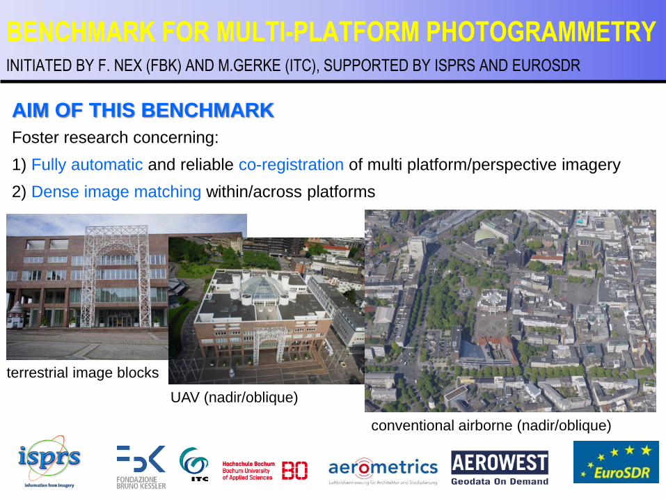
terrestrial image blocks
UAV (nadir/oblique)
conventional airborne (nadir/oblique)
AIM OF THIS BENCHMARK
Foster research concerning:
1) Fully automatic and reliable co-registration of multi platform/perspective imagery
2) Dense image matching within/across platforms
INITIATED BY F. NEX (FBK) AND M.GERKE (ITC), SUPPORTED BY ISPRS AND EUROSDR
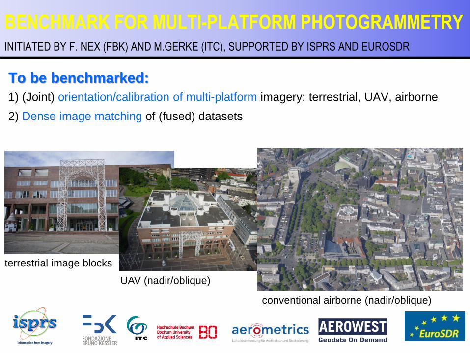
To be benchmarked:
1) (Joint) orientation/calibration of multi-platform imagery: terrestrial, UAV, airborne
2) Dense image matching of (fused) datasets
BENCHMARK FOR MULTI-PLATFORM PHOTOGRAMMETRY
terrestrial image blocks
UAV (nadir/oblique)
conventional airborne (nadir/oblique)
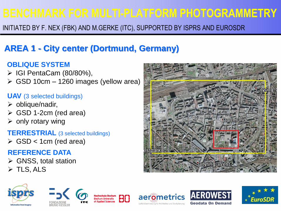
AREA 1 - City center (Dortmund, Germany)
BENCHMARK FOR MULTI-PLATFORM PHOTOGRAMMETRY INITIATED BY F. NEX (FBK) AND M.GERKE (ITC), SUPPORTED BY ISPRS AND EUROSDR
OBLIQUE SYSTEM
IGI PentaCam (80/80%),
GSD 10cm – 1260 images (yellow area)
UAV (3 selected buildings)
oblique/nadir,
GSD 1-2cm (red area)
only rotary wing
TERRESTRIAL (3 selected buildings)
GSD < 1cm (red area)
REFERENCE DATA
GNSS, total station
TLS, ALS
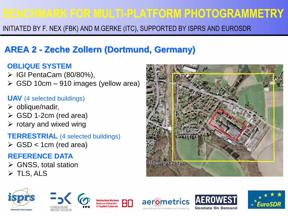
AREA 2 - Zeche Zollern (Dortmund, Germany)
BENCHMARK FOR MULTI-PLATFORM PHOTOGRAMMETRY INITIATED BY F. NEX (FBK) AND M.GERKE (ITC), SUPPORTED BY ISPRS AND EUROSDR
OBLIQUE SYSTEM
IGI PentaCam (80/80%),
GSD 10cm – 910 images (yellow area)
UAV (4 selected buildings)
oblique/nadir,
GSD 1-2cm (red area)
rotary and wixed wing
TERRESTRIAL (4 selected buildings)
GSD < 1cm (red area)
REFERENCE DATA
GNSS, total station
TLS, ALS
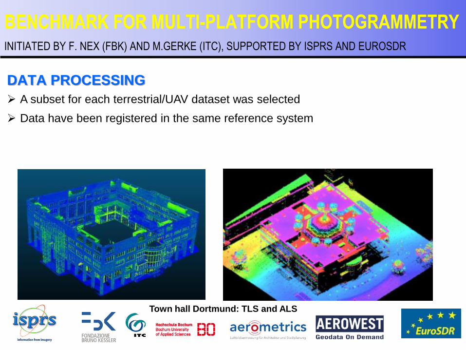
DATA PROCESSING
A subset for each terrestrial/UAV dataset was selected
Data have been registered in the same reference system
BENCHMARK FOR MULTI-PLATFORM PHOTOGRAMMETRY INITIATED BY F. NEX (FBK) AND M.GERKE (ITC), SUPPORTED BY ISPRS AND EUROSDR
Town hall Dortmund: TLS and ALS
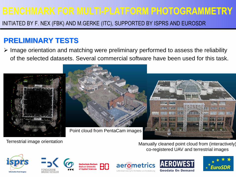
PRELIMINARY TESTS
Image orientation and matching were preliminary performed to assess the reliability
of the selected datasets. Several commercial software have been used for this task.
BENCHMARK FOR MULTI-PLATFORM PHOTOGRAMMETRY INITIATED BY F. NEX (FBK) AND M.GERKE (ITC), SUPPORTED BY ISPRS AND EUROSDR
Manually cleaned point cloud from (interactively)
co-registered UAV and terrestrial images
Point cloud from PentaCam images
Terrestrial image orientation

EVALUATION CRITERIA – IMAGE MATCHING
INPUT
Images with fixed orientation and
calibration (selected parts)
PROVIDED BY PARTICIPANTS
Point clouds on selected areas
EVALUATION
According to [Cavegn, 2014]
In collaboration with: EuroSDR
BENCHMARK FOR MULTI-PLATFORM PHOTOGRAMMETRY INITIATED BY F. NEX (FBK) AND M.GERKE (ITC), SUPPORTED BY ISPRS AND EUROSDR
Data now available!
(Zeche Zollern PentaCam and
UAV/terrestrial block, see also
https://sketchfab.com/models/1b2ac36
1731d45da9134d74fd3677fa5 )

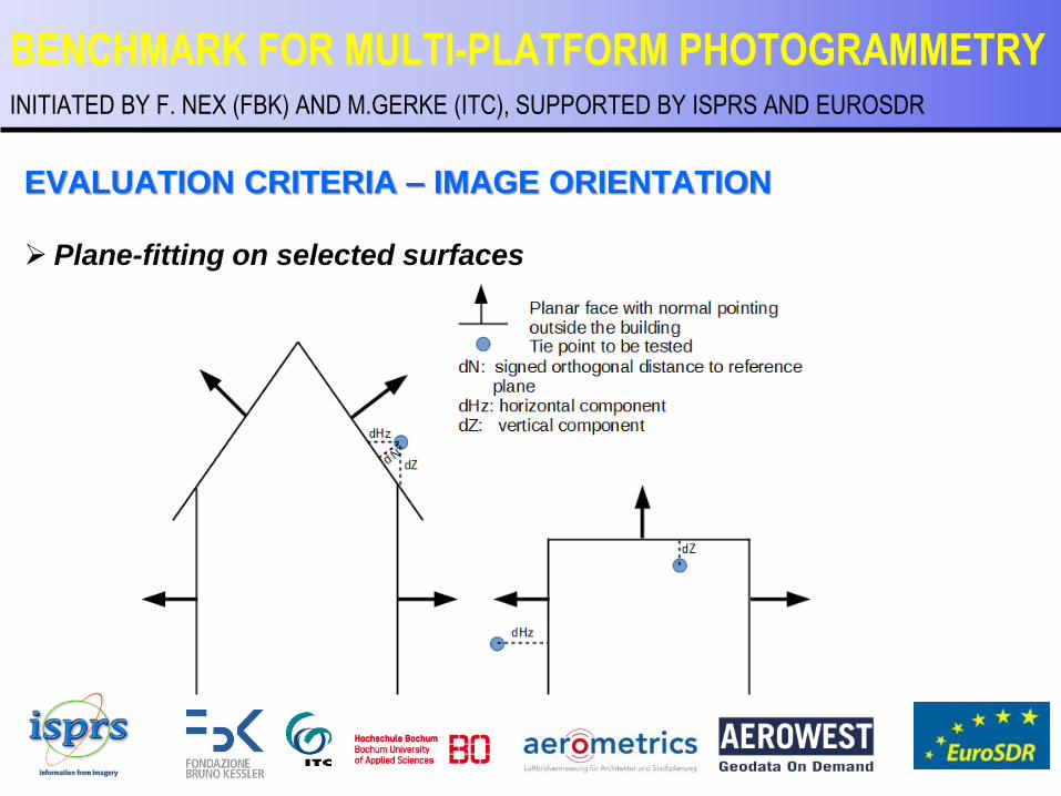
EVALUATION CRITERIA – IMAGE ORIENTATION
INPUT
Images with approximate orientation and calibration (if available)
GCP (different configurations): image and 3D coordinates
CP: image coordinates.
PROVIDED BY PARTICIPANTS
CP 3D coordinates + sparse point cloud (tie-points)
EVALUATION
Residuals CP
Plane-fitting on selected surfaces
BENCHMARK FOR MULTI-PLATFORM PHOTOGRAMMETRY INITIATED BY F. NEX (FBK) AND M.GERKE (ITC), SUPPORTED BY ISPRS AND EUROSDR
Data available later this year
Useful for
camera head
calibration
EVALUATION CRITERIA – IMAGE ORIENTATION
Plane-fitting on selected surfaces
BENCHMARK FOR MULTI-PLATFORM PHOTOGRAMMETRY INITIATED BY F. NEX (FBK) AND M.GERKE (ITC), SUPPORTED BY ISPRS AND EUROSDR
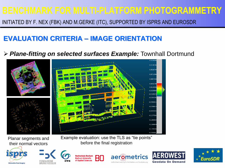
EVALUATION CRITERIA – IMAGE ORIENTATION
Plane-fitting on selected surfaces Example: Townhall Dortmund
BENCHMARK FOR MULTI-PLATFORM PHOTOGRAMMETRY INITIATED BY F. NEX (FBK) AND M.GERKE (ITC), SUPPORTED BY ISPRS AND EUROSDR
Planar segments and
their normal vectors
Example evaluation: use the TLS as “tie points”
before the final registration
EVALUATION CRITERIA – IMAGE ORIENTATION
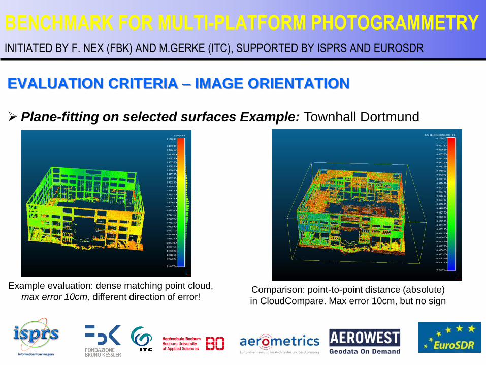
Plane-fitting on selected surfaces Example: Townhall Dortmund
BENCHMARK FOR MULTI-PLATFORM PHOTOGRAMMETRY INITIATED BY F. NEX (FBK) AND M.GERKE (ITC), SUPPORTED BY ISPRS AND EUROSDR
Example evaluation: dense matching point cloud,
max error 10cm, different direction of error! Comparison: point-to-point distance (absolute)
in CloudCompare. Max error 10cm, but no sign
EVALUATION CRITERIA – IMAGE ORIENTATION
Plane-fitting on selected surfaces
Prilimilary observations:
Signed distance helpful, in both close range and airborne data (at least for height element): direction of error helps to interpret result.
TLS registration must be very accurate to provide useful results.
BENCHMARK FOR MULTI-PLATFORM PHOTOGRAMMETRY INITIATED BY F. NEX (FBK) AND M.GERKE (ITC), SUPPORTED BY ISPRS AND EUROSDR
CONCLUSIONS
Benchmark should give new insights into multi-perspective/-
resolution photogrammetry and stimulate research
Data free of charge and usage not bound to benchmark playground
for other applications (City modeling, 3D GIS, cultural heritage
documentation strategies…)
Evaluation of results a task on its own new insights expected, as
well
BENCHMARK FOR MULTI-PLATFORM PHOTOGRAMMETRY INITIATED BY F. NEX (FBK) AND M.GERKE (ITC), SUPPORTED BY ISPRS AND EUROSDR

BENCHMARK FOR MULTI-PLATFORM PHOTOGRAMMETRY INITIATED BY F. NEX (FBK) AND M.GERKE (ITC), SUPPORTED BY ISPRS AND EUROSDR
Thanks for your attention!
WEBSITE:
http://www2.isprs.org/commissions/comm1/icwg15b/benchmark_main.html
NEWSLETTER: http://www2.isprs.org/newsletter.html
CONTACTS:
Francesco Nex [email protected]
Markus Gerke [email protected]