Embed Size (px)
Citation preview

ISRO / UKSA Joint Working Group University of Reading29 March 2011
Use of observational information for convective-
scale predictions
Stefano MiglioriniUniversity of Reading
with contributions from: Ross Bannister, Mark Dixon, Stephen English, Graeme Kelly, Cristina Prates, Randhir
Singh and Robert Tubbs

2
Contents
• Probabilistic forecasting at convective-scale
• Operational radiative transfer modelling for NWP
• Assimilation of cloudy radiances
• Advanced wind measurements from space

High-resolution numerical weather predictions
• Increase of computer power allows met agencies to run NWP forecasts at increasing resolution: deep-convection permitting models (~1 km res)
• Less need for parameterizations (e.g. convection) and better topography and surface fields
• Better use of high-res observation
• Aim is to improve forecasts of small-scale processes, storms, hazardous weather
3
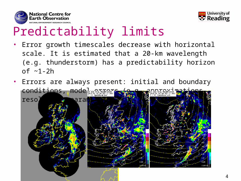
Predictability limits• Error growth timescales decrease with horizontal scale. It
is estimated that a 20-km wavelength (e.g. thunderstorm) has a predictability horizon of ~1-2h
• Errors are always present: initial and boundary conditions, model errors (e.g. approximations, resolution, parameterizations)
4

Ensemble prediction at convective scale
• Error growth at convective scale stronger in the presence of convective instability: need for accurate representation of ongoing convection at initial time (e.g., from radar), particularly for nowcasting (0-6 hours).
• Large sensitivity to initial conditions and to model error motivates the need for probabilistic forecasts at convective scale.
• Initial-condition uncertainty for nowcasting should depend on available observational information content: ensemble filtering
• We also obtain flow-dependent (but low-rank) description of forecast uncertainty that can be used for high resolution data assimilation
5

The Met Office EPS
6
• Met Office Global and Regional Ensemble Prediction System (MOGREPS)
• BC from the global ensemble
• IC calculated using an ETKF
to generate 23 increments
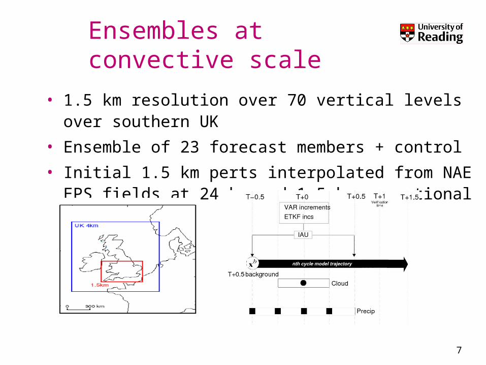
Ensembles at convective scale
• 1.5 km resolution over 70 vertical levels over southern UK
• Ensemble of 23 forecast members + control
• Initial 1.5 km perts interpolated from NAE EPS fields at 24 km and 1.5 km operational analysis
7

Case study: 26 July 2007• active front, line convection, strong dynamical forcing

9
• T+1 forecast valid at 12 UTC, with LH nudging acting between 10.30 and 11.30.
• Substantial variability that “compensate” shortcomings in deterministic forecast (member 0): heavy rainfall over the north coast of South West England captured by members 2, 3, 4, 6 and 18; light precip in the East by several member (e.g., 11)
Case study: forecasts of precipitation

Sensing the Earth from space
• Line-by-line models calculates absorption coefficients for each spectral line for all relevant molecules over layers
• Radiative transfer equation solved; top-of-atmosphere monochromatic radiance convolved with instrument response; computationally expensive
• “fast” RT codes (e.g. RTTOV) determine transmittance from optical depth calculated as regression of set of predictors (T, WV)
10
2
1
22 1 1 2
( , )( ) ( ) ( , ) ( ( ))
s
s
d s sL s L s s s B T s ds
ds
2
1
1 20
( , ) exp( ( ( )) ( ) )abs
s N
m mms
s s s s ds

• A fast radiative transfer model (RTM) to compute emitted infrared radiances for a very high resolution radiometer (VHRR), onboard the operational Indian geostationary satellite Kalpana has been developed and verified (Singh et al., 2009) . This work is a step towards the assimilation of Kalpana water vapor (WV) radiances into numerical weather prediction models.
11
Operational radiative transfer codes
Singh, Rayer, Saunders, Migliorini, Brugge, O’Neill, 2009

Assimilation of cloudy radiances (1/2)
• Satellite observations regarding clouds can be assimilated as either raw radiances or as retrieved parameters.
• RTMs used in assimilation assume a simple cloud model: a single layer of geometric thin grey cloud
12
Cld Cl Opc c cL ( ) (1 N )L ( ) N L ( ,p )
Cloud Parameters: Effective Cloud Fraction (ECF) and Cloud Top pressure (CTP)
Cloud-free radiance Radiance for 100% opaque cloud cover

• Statistics of 1D-Var retrieval obtained from a set of 200 pseudo IASI observations where a layer of cirrus cloud type is placed above a layer of cumulus cloud. The true cloud top is represented in orange and the retrieved in blue.
• New two-layer cloud model to increase the number of assimilated cloud-affected radiances
13
cld clr op ope1 e2 e1 1 e2 e1 2L ( ) (1 N )(1 N )L ( ) N L (p , ) N (1 N )L (p , )
Assimilation of cloudy radiances (2/2)
Thanks to Cristina Prates
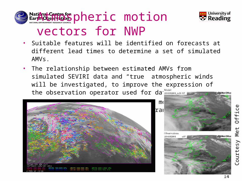
Atmospheric motion vectors for NWP
• Suitable features will be identified on forecasts at different lead times to determine a set of simulated AMVs.
• The relationship between estimated AMVs from simulated SEVIRI data and “true” atmospheric winds will be investigated, to improve the expression of the observation operator used for data assimilation.
• Experiments will be performed with model data at different horizontal resolutions, ranging from 1.5 km to 500 m.
14
Court
esy
Met
Offi
ce

Conclusions
15
• Accurate weather prediction relies on accurate observations and reliable models
• Uncertainty is inevitable (finite predictability) and needs to be quantified for meaningful predictions
• Satellite information is essential to guarantee global coverage
• Still a lot of research needs to be done to improve predictions at high-resolution (clouds, storms, high-impact weather)