Embed Size (px)
Citation preview
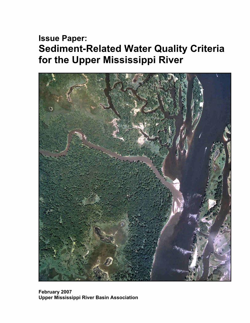
Issue Paper: Sediment-Related Water Quality Criteria for the Upper Mississippi River
February 2007 Upper Mississippi River Basin Association
Upper Mississippi River Basin Association 415 Hamm Building, 408 St. Peter Street St. Paul, Minnesota 55102 651-224-2880 (phone) 651-223-5815 (fax) www.umrba.org
Front cover photo depicting Root River Area of Upper Mississippi River Pool 8 courtesy of Upper Midwest Environmental Sciences Center, La Crosse, Wisconsin
ISSUE PAPER: SEDIMENT-RELATED WATER QUALITY CRITERIA FOR THE UPPER MISSISSIPPI RIVER Prepared by Upper Mississippi River Basin Association Water Quality Task Force 415 Hamm Building 408 St. Peter Street St. Paul, MN 55102 and FTN Associates, Ltd. 3 Innwood Circle, Suite 220 Little Rock, AR 72211 in consultation with Wenck Associates, Inc. 1800 Pioneer Creek Center Maple Plain, MN 55359 Under Grants from US EPA Region 5 (CP-96561101-1) and US EPA Region 7 (CP-98752601-0)

1
Executive Summary As a complex, multi-use, inter-jurisdictional resource, the Upper Mississippi River (UMR) presents a variety of challenges for water quality management. Among the most prominent is the challenge of managing sediment to protect the river ecosystem and, in Clean Water Act terms, to support aquatic life and other designated uses for the river. In both scientific reports and the popular press, excess suspended sediment and sedimentation are often cited as important water quality concerns for the UMR. However, the concern regarding sediment impacts on the UMR is not necessarily reflected in the States’ impairment lists developed under the Clean Water Act. The large majority of UMR river segments have not been identified as sediment-impaired by the States under the Clean Water Act. Additionally, where sediment-related impairments have been identified, this impairment listing is often not shared by both States bordering a river segment. These apparent mismatches in the characterization of sediment-related problems on the UMR may result both from uncertainties regarding the extent to which the ecosystem is actually impacted by sediment, and from differences in the States’ implementation of the Clean Water Act. Additionally, these disparities can send mixed messages to the public, trigger differing corrective actions by States, and potentially result in varied expectations for the regulated community. Investigating Sediment-Related Water Quality Criteria for the Upper Mississippi River The UMRBA Water Quality Task Force (WQTF) recognized the potential problems associated with the current characterization of sediment impairments on the UMR, and chose to investigate this issue in greater detail as part of its ongoing efforts to improve cooperation and coordination on UMR water quality issues. Through a series of meetings, discussions, and associated research, the WQTF sought to examine the transport and fate of sediment the UMR, assess the extent to which sediment-related impacts on aquatic life occur on the UMR, and review the States’ current approaches to characterizing sediment impairment. Information gathered in these efforts is found in Chapters 2, 3, and 4 of this issue paper. Following a review of the background information, the WQTF sought to determine what common approaches could be taken by States in addressing sediment issues. Specifically, the possibilities for mutual development of sediment-related water quality criteria for the UMR were explored. WQTF Consensus Statements The WQTF drafted the following “consensus statements” during their initial deliberations, which both reflected their current, common understanding of sediment issues, and set the stage for further action: The UMR is a significant ecosystem that has been modified as a result of both anthropogenic
changes within the watershed and engineering modifications to support navigation. The ecosystem must be protected and enhanced in order to support and maintain its designated uses, including aquatic life uses.
Although tributary sediment loads to the UMR have decreased from historic highs, due to improved land use practices and impoundments, significant sources of sediment still exist, including internal sources. The existing sediment regime is not in equilibrium and net deposition is occurring in certain areas of the river and its backwaters.
Differences in watershed characteristics, river geomorphology, and development for navigation have resulted in longitudinal differences in sediment characteristics and transport along the UMR.
2
In some segments of the UMR, sediment-related impacts are having a negative effect on aquatic life. Some UMR States have considered these effects to constitute an impairment of their aquatic life designated use.
Aquatic life is generally considered a sensitive use when determining impairment. Thus, protection of aquatic life use will likely generally ensure protection for other uses.
Conclusions Regarding a Future Approach to Addressing Sediment on the UMR The consensus statements helped lead the WQTF to the conclusion that further action is needed and that the States should move forward at this time, despite the uncertainties and complexities associated with the issue. After considering a variety of options for future action, the WQTF concluded that: Sediment-related work should be focused on the development of common water quality criteria in
the near term.
A guidance document should be developed for the States to use, as appropriate, in making any changes to water quality standards or their interpretation.
Criteria development efforts should initially be focused on suspended sediments.
Issues associated with bedded sediments should be further investigated by preparing a white paper on the topic.
In the near term, the most appropriate approach may be to develop “numeric translators” for States’ existing narrative criteria, and provide these translators in a UMR guidance document.
Criteria should be developed that are specific for the UMR, accommodate longitudinal and lateral variation of the river, and are applicable for ongoing (chronic) conditions.
The values presented in the UMRCC’s SAV protection criteria proposal should be incorporated into the UMR guidance for sediment-related water quality criteria.
The first area for which guidance should be developed is suspended sediments on the upper impounded reach of the UMR (through Pool 13).
Attributing sediment-related impairments to “pollution” is not likely appropriate for suspended sediment, but may have some applicability for bedded sediment.
The “pollution” categorization option should be considered in greater detail in the proposed white paper on bedded sediment.
The States should remain in the primary regulatory role, with UMRBA playing a complimentary role in drafting the guidance document and other associated documents. US EPA should provide technical support and expertise.
Recommendations In light of their conclusions regarding preferred courses of cooperative action and their determination that additional effort is necessary at this time, the WQTF offers the following recommendations to address sediment-related water quality on the UMR: 1. The States and U.S.EPA, working through UMRBA, should develop a guidance document
regarding sediment-related water quality criteria for the UMR.
2. The States and U.S. EPA, working through UMRBA, should develop a white paper that evaluates alternative approaches to address bedded sediment on the UMR.
3
3. The States and U.S. EPA, working through UMRBA, should draft a research needs list to help guide further investigations regarding sediment-related water quality problems on the UMR.
The WQTF plans to work in cooperation with the UMRBA and its Water Quality Executive Committee, as well as U.S. EPA, to implement these recommendations and move forward in addressing sediment-related water quality issues on the UMR.

4
5
Preface
In January 2004, the UMRBA published a report entitled Upper Mississippi River Water Quality: The States’ Approaches to Clean Water Act Monitoring, Assessment, and Impairment Decisions. The report concluded that “enhanced consistency and coordination of water quality management on the Upper Mississippi River is both necessary and possible.” It also identified sediment-related water quality criteria as one of the specific areas where potential progress could be made in the short term. This Issue Paper, which summarizes available information related to sediment impacts on the Upper Mississippi River and considers options for addressing them, is a first step toward making progress in this area. The report was prepared by the UMRBA Water Quality Task Force, which it offers to both the Governor-appointed UMRBA representatives and the UMRBA Water Quality Executive Committee, for their consideration in setting priorities and facilitating progress regarding coordinated water quality protection efforts on the Upper Mississippi River. Other individuals and organizations with an interest in Upper Mississippi River water quality may also find value in the information presented within this report.
About the UMRBA:
The UMRBA is a 501(c)(3) nonprofit organization established in 1981 by the Governors of the five States that border the Upper Mississippi River to facilitate dialogue and cooperative action among the States and to work with federal agencies on inter-jurisdictional river programs and policies. In 1998, the UMRBA formed a Water Quality Task Force to address technical and regulatory water quality topics of importance on the Upper Mississippi River. The Task Force is composed of representatives from each of the five basin State’s environmental protection agencies: Illinois Environmental Protection Agency, Iowa Department of Natural Resources, Minnesota Pollution Control Agency, Missouri Department of Natural Resources, and Wisconsin Department of Natural Resources. Representatives from US EPA Regions 5 and 7 also participate in the Task Force. A UMRBA Water Quality Executive Committee was also chartered by the UMRBA in 2006. The Executive Committee is composed of water quality administrators from each of the five State environmental protection agencies and provides policy-level coordination on Upper Mississippi River water quality issues.

6
7
Sediment-Related Water Quality Criteria for the Upper Mississippi River UMRBA Task Force Members and Project Participants
Illinois Environmental Protection Agency Gregg Good Matt Short Iowa Department of Natural Resources Chuck Corell Tim Hall Lori McDaniel John Olson Minnesota Pollution Control Agency Marvin Hora Norman Senjem Missouri Department of Natural Resources Mohsen Dkhili Mark Osborn Wisconsin Department of Natural Resources James Baumann John Sullivan United States Environmental Protection Agency, Region 5 Holly Arrigoni Bill Franz Mari Nord United States Environmental Protection Agency, Region 7 Larry Shepard Consultants Dennis Ford, FTN Associates Christina Laurin, FTN Associates John Thene, Wenck Associates UMRBA Staff Dave Hokanson Holly Stoerker Marjorie Daniels

8
9
Table of Contents Executive Summary.................................................................................................................. 1 Preface ...................................................................................................................................... 5 Chapter 1: Introduction.......................................................................................................... 11 Chapter 2: An Overview of Sediment Sources, Transport, and Deposition on
the UMR ........................................................................................................... 17 Chapter 3: Sediment Impacts on Aquatic Life and Other Designated Uses.......................... 29 Chapter 4: States’ Current Approaches to Sediment on the UMR........................................ 41 Chapter 5: Options for Developing Common Approaches to Sediment-Related Water Quality Criteria on the UMR .................................................................... 55 Chapter 6: Conclusions and Recommendations .................................................................... 63 References ............................................................................................................................... 67 Appendix 1: Sediment Definitions ........................................................................................... 71 Appendix 2: Geomorphic and Sediment Characteristics of the UMR by Assessment Reaches ......................................................................................... 73 Appendix 3: UMRCC-Water Quality Technical Section Proposal: SAV Protection Criteria .............................................................................................................. 77 Appendix 4: Draft MOU: Sediment-Related Water Quality Criteria for the Upper Mississippi River .............................................................................................. 89 Appendix 5: Preliminary Investigation and Research Needs List ......................................... 93

10
11
Chapter 1 Introduction
Sediment, Water Quality, and Aquatic Life The levels of suspended and bedded sediments present in a waterbody can affect the physical, chemical, and biological quality of that waterbody. Excess sediment levels can have effects on ecological integrity at several scales and trophic levels, and can impact other waterbody uses including navigation, recreation, and drinking water supply (US EPA 2006b). Sediment is a naturally occurring component of aquatic ecosystems, and the transport and deposition of sediment are natural processes in waterbodies. However, sediment imbalance – and most specifically excess sediment – is a significant concern for water quality and aquatic life. Sediment imbalance is often the result of human activities, though natural contributions to sediment imbalance exist as well. Sediment and sedimentation have been recognized as leading causes of waterbody impairment nationally (US EPA 2003b) and have been identified by EPA as a priority area for improving the quality of the Nation’s waters (US EPA 2003b). Turbidity, suspended solids, sediment, and siltation have been frequently listed in the States’ Clean Water Act Section 305(b) Water Quality Assessments and Section 303(d) Impairment Lists as causes of waterbody impairment. In 1998, for example, approximately 40% of assessed river miles in the U.S. had problems arising from sediment stress (US EPA 2000). Even though sediment frequently triggers an impairment listing, it is difficult to assess the specific extent of sediment impacts nationwide, as individual States’ criteria can be quite varied or even absent entirely. Additionally, there is no national water quality guidance for sediment criteria applicable to large rivers such as the Mississippi. US EPA has recently released a framework to aid States in designing a consistent approach to the development of sediment-related criteria (US EPA 2006b), but even with such a framework in place, much work remains to be done in the development of sediment-related water quality criteria appropriate for the diversity of the nation’s waterbodies and the diversity within certain waterbodies. Adding to the complexity of addressing sediment is the potential for remedies to be very large in scope and scale. As primarily a non-point source pollution issue, sediment problems could require remedies that may be basin-wide and include such sectors such as navigation and agriculture. In summary, there is a national recognition of the potential impacts of sediments, both suspended and bedded, on the quality of the Nation’s water resources. However, there is also great complexity present in establishing appropriate criteria, assessing the true extent of the problem, and in resolving sediment-related impairments. Sedimentation and Sediment-Related Water Quality Criteria on the UMR This mixture of concern and complexity is both reflected and amplified in the Upper Mississippi River (UMR). Several reports and observers have cited sediment as a concern for the UMR (UMRBA 1984, Lubinski 1993, USGS 1999, UMRCC 2000, USACE 2004, USFWS 2006). However, this is not necessarily reflected in the States’ biennial water quality assessments under the Clean Water Act. In 2004, just six out of a total of 59 assessed UMR segments were listed as impaired under Section 303(d) of the Clean Water Act due to sedimentation or sediment-related parameters (for “clean” sediments). Additionally, in all cases of sediment-related impairment, these river segments were listed as impaired by only one of the States that border that segment of the river (see Chapter 4 for more details).
12
These apparent mismatches occur, in part, because there currently are no generally accepted numeric indicators of impairment due to sedimentation or sediment-related water quality (US EPA 2003a). Most UMR States’ water quality standards include only narrative water quality criteria for sediment-related effects, with Minnesota alone having a directly-applicable numeric water quality criterion (i.e., for the sediment-related parameter of turbidity). Several problems arise from disparities in UMR States’ approaches to sediment on the UMR. The States’ Section 303(d) listings for shared portions of the UMR have potential economic and regulatory implications for discharges into listed river segments, as differences in listings can create an “unequal playing field” for discharge permit holders on opposite sides of the river. Disparate listings also have implications regarding corrective actions, such as TMDLs, required to be implemented for the listed segments—creating a mismatch in how States characterize and address problems. Finally, and perhaps most importantly, listing differences result in a mixed message to the public regarding the status of the river. UMRBA Water Quality Task Force’s Sediment-Related Water Quality Criteria Project The implications of and potential problems associated with inconsistent sediment-related listings motivated the UMRBA Water Quality Task Force (WQTF) to address this issue, despite the complexity associated with the problem. Beginning in August 2005, the WQTF chose to explore the opportunities for enhancing consistency in how sediment-related assessment and impairment decisions are made on the UMR. An ongoing goal of the WQTF, and UMRBA overall, has been to encourage compatibility and consistency in water quality protection among the UMR States. US EPA has also strongly encouraged States to consult each other regarding assessments and impairment decisions on shared waters (US EPA 2005). Additionally, other organizations look to UMRBA to facilitate harmonization of water quality criteria (USFWS 2006). This project to address sediment-related water quality criteria was seen as an opportunity to address one area where consistency in approach could be improved.
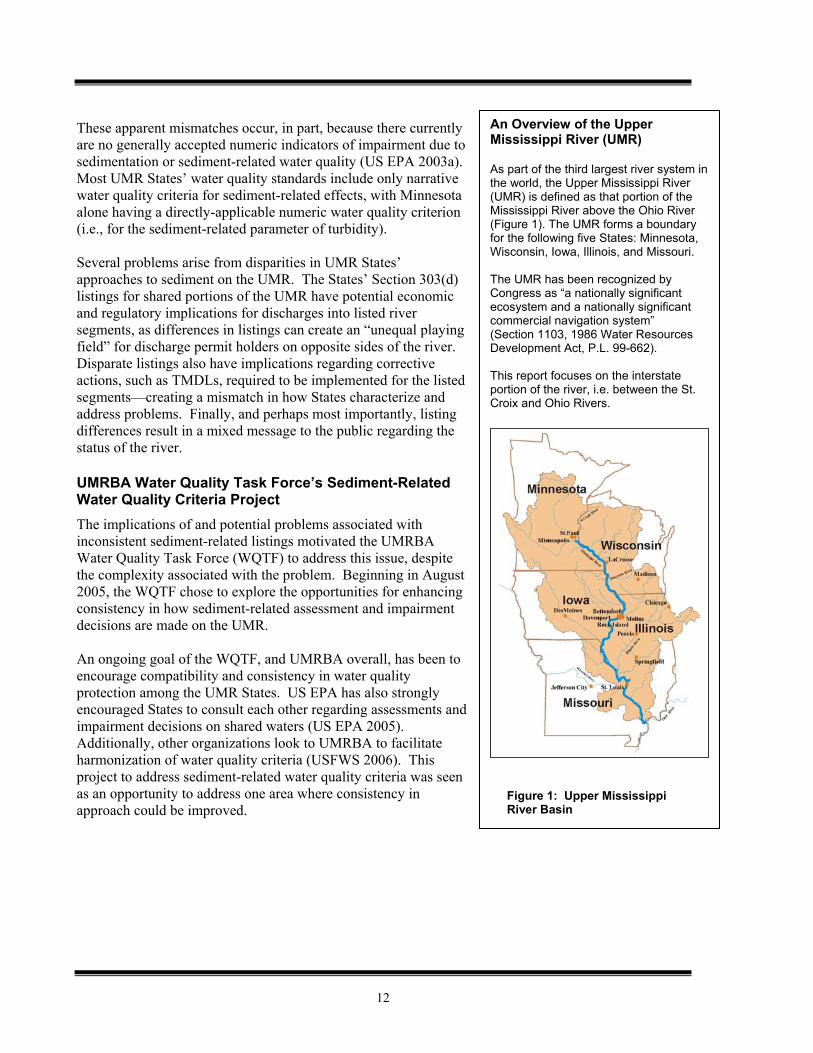
An Overview of the Upper Mississippi River (UMR) As part of the third largest river system in the world, the Upper Mississippi River (UMR) is defined as that portion of the Mississippi River above the Ohio River (Figure 1). The UMR forms a boundary for the following five States: Minnesota, Wisconsin, Iowa, Illinois, and Missouri.
The UMR has been recognized by Congress as “a nationally significant ecosystem and a nationally significant commercial navigation system” (Section 1103, 1986 Water Resources Development Act, P.L. 99-662). This report focuses on the interstate portion of the river, i.e. between the St. Croix and Ohio Rivers.
Figure 1: Upper Mississippi River Basin
13
The Challenge in Addressing Sediment-Related Water Quality Criteria on the UMR Sediment has historically been a problematic area for developing consistent approaches on the UMR for a variety of reasons, including the following: Sediment loading and transport rates vary longitudinally, horizontally, and seasonally on the UMR.
Modification of the UMR for navigation has altered sedimentation rates and patterns. It is also not clear that post-impoundment equilibrium has been reached. As a result, it is difficult to establish a desired – and attainable – condition for the river in terms of sediment as it relates to the protection of aquatic life.
While sediment is generally believed to have adverse affects on aquatic life and other designated uses on the UMR, direct linkages between specific occurrence and specific impact have not been completely documented.
States do not have common criteria to assess sediment impairment; nor do they have a common assessment approach.
Data gaps exist regarding suspended sediment concentrations, sediment transport rates, deposition rates, historic occurrence of submerged aquatic vegetation and other parameters relevant to the issue.
Problems with sediment are potentially large in scope and complexity, and solutions may be equally far-reaching and complex.
Despite the complexity and challenges, the WQTF believes that sediment criteria for the UMR is an important issue to address. In part, the States are seeking to minimize the problems associated with the inconsistencies mentioned earlier. Additionally, however, this is an opportunity to pool resources and experiences to address a particularly challenging issue, with the hope of generating an efficient and effective approach for all involved. Project Approach The WQTF developed the following project scope, project goals, guiding research questions, and schedule of activities and products to guide its work on sediment-related water quality criteria. Project Scope
This effort is directed at addressing uncontaminated or “clean” sediments, meaning that it does not directly address issues such as nutrients or toxic chemicals present in sediments (see sidebar). The scope of the project includes both sediments in the water column (suspended sediments) and sedimentation (bedded sediment). Geographically, the focus of the project is on the main stem of the UMR, including associated side channels and backwaters. The project scope does not directly include tributaries or the UMR basin at large. Additionally, the project does not directly address sediment management activities such as dredging and disposal.
Sediment, Nutrients, and Toxics The WQTF chose to focus this project on “clean” sediment, rather than to directly address issues of nutrients, toxics, or other materials that could potentially occur in sediment.
Although these co-occurring contaminants are important, they were not addressed at this time for reasons including:
1) Other criteria have been developed, or are being developed to address these parameters.
2) An understanding that addressing sediment overall can produce beneficial reductions in these associated contaminants.
3) A desire to limit the complexity of the current effort to a manageable scale.
14
Project Goals and Research Questions
The ultimate goal of this effort is the development of mutually agreeable approaches to making sediment-related Clean Water Act impairment decisions on the UMR which will be protective of aquatic life. However, this goal is more far-reaching than can be attained during the initial project timeline. Therefore, the following series of incremental goals, and associated research questions, were developed to guide progress toward the project’s ultimate goal:
Incremental Project Goal Associated Research Question(s)
Enhancing the States’ understanding of the sources, transport, and deposition of sediment on the UMR.
What are the sources of sediment on the UMR and how is sediment transported and deposited?
Enhancing the States’ understanding of the expected and documented impacts of sediment on aquatic life in the UMR.
What are the documented, and expected, impacts of sediments and sedimentation on aquatic life in the UMR?
Enhancing the States’ understanding of each other’s approaches to sediment-related water quality criteria, and identifying areas of agreement and differences.
What are each State’s standards and/or assessment methodologies for sediment-related parameters, such as turbidity, total suspended solids, and siltation rates?
What are the primary differences among the States? What are the impacts/results of these differences?
Identifying issues that currently prevent consistent approaches among States, including research and information gaps.
What are the key scientific, policy, and legal issues associated with sediment impact assessment and impairment decisions on the UMR?
Where possible, developing common approaches to sediment-related water quality criteria.
What are the options for enhancing consistency in sediment impact assessments and listings on the UMR, including development of sediment-related impairment criteria?
How can the submersed aquatic vegetation (SAV) criteria recommended by the UMR Conservation Committee –Water Quality Technical Section be used in assessment and impairment decisions?
Project Activities and Products
This project was carried out as an ongoing consultation within the WQTF, with accompanying facilitation and research by UMRBA staff and project consultants. The following specific products and activities have been part of the project approach: Background Report: Designed to provide background information to facilitate discussion at
November 2005 workshop. Draft background report issued October 2005.
Workshop: Designed to provide background information to all participants in the project, as well as to begin discussion of preferences, issues, challenges, and research needs. Held November 2-3, 2005.
Options Paper: Designed to: 1) summarize discussions at workshop and background information, and 2) present options for action to the WQTF. Completed January 2006.
15
Consultation Meeting: Designed for the discussion of options, selection of options, and development of an implementation approach. Held February 8-9, 2006, with subsequent consultations at the June and September 2006 WQTF meetings.
Issue Paper: This final report that combines content from the draft background report, draft options paper, outcome of the consultation meeting and other WQTF discussions. It includes recommendations for action agreed upon by the WQTF. The chapters of the report are largely organized around the research questions listed above.

16
17
Chapter 2 An Overview of Sediment Sources, Transport, and Deposition on the UMR
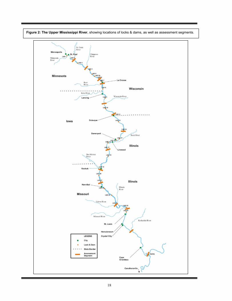
This chapter provides an overview of sediment sources, transport and deposition on the UMR, with the recognition that it is a complex and diverse system to describe. Factors contributing to this complexity, and described in the following sections include: 1) multiple sources of sediment, 2) longitudinal variation, 3) lateral variation, and 4) temporal variation. To aid in understanding sediment sources and transport on the UMR, Figure 2 on the following page illustrates the locations of locks and dams, major tributaries to the UMR, and the reaches used by the States for water quality assessment purposes.
Sediment Sources Sediment sources for the UMR main stem include both the sediment carried by runoff from the landscape and in-stream sources. These runoff and in-stream processes also contribute sediment to UMR tributaries, which in turn carry the sediment to the river’s main stem. Upland Erosion and Run-Off from the Landscape
The amount of sediment reaching the river due to erosion and runoff is certainly greater than that of the pre-settlement area, due to the conversion of land into urban and agriculture uses. However, while erosion and runoff remain significant sources of sediment, erosion rates have been reduced from historic highs due to improved land management practices (USGS 1999). In-Stream Sources and Re-Suspension
As improved land management practices have reduced sediment contributions from the landscape, in-stream sources of sediment have become more prominent relative contributors of sediment to the river. These sources include re-suspension of deposited sediments and bank erosion. In-stream sediment sources may be more significant contributors than landscape sources for some areas of the river. Sediment Contribution from Tributaries
UMR tributaries contribute sediment to the main stem through both of the processes described above and greatly influence the nature of sediment in the main stem (Nielsen 1984). Certain tributaries contribute the largest amounts of sediment to the main stem of the UMR. In terms of suspended sediment, these include the Minnesota River, Des Moines River, Illinois River, Iowa River, Skunk River, and Missouri River. Additionally, the sediment stored in the banks and beds of tributaries is a long-term potential source of sediment for the UMR (USGS 1999). Among the tributaries, the Missouri River is notable because – while it carries a large amount of sediment to the UMR – the construction of impoundments on the Missouri has created “sediment sinks” and actually decreased its sediment loading to the UMR to pre-1930s levels (Lubinski 1993).
Research Question: What are the sources of sediment on the UMR and how is sediment transported and deposited?
18
Figure 2: The Upper Mississippi River, showing locations of locks & dams, as well as assessment segments.
19
Longitudinal Variations in Sediment on the UMR One apparent variation in sediment on the UMR is the change in sediment loading and sediment concentrations that occurs from north to south on the river. Overall, the average annual suspended sediment discharge of the Mississippi River increases by a factor of approximately 180 from St. Paul, Minnesota to the confluence with the Ohio River (WEST 1998), due to both increased sediment concentrations and flow rates. However, the loading and fate of the sediment is not uniform along the course of the river. Longitudinal variations are described in more detail in the following text. Factors Influencing Longitudinal Variation in Sediment
Several physical properties of the river and the basin contribute to the longitudinal differences in the sediment characteristics of the UMR. These include:
Sediment loads contributed by tributaries. Tributaries provide significant inputs of sediment to the river. However, in some cases, such as the St. Croix River, sediment concentrations may be lower in the tributary than in the main stem.
Riverbed geology/river channel morphology (i.e., shape, slope, and stability of the river channel). For example, low energy slopes in the impounded portion of the UMR (i.e. upstream of St. Louis) limit the capacity of the river to transport suspended sediments that are larger than silt or clay (WEST 1998). See Appendix 2 for a detailed description of river morphology and its relationship to sediment levels.
River modifications for navigation. UMR sediment-related water quality is influenced by the system of locks and dams on the river between Minneapolis and St. Louis, which creates a series of impoundments that have significantly altered the way in which the UMR processes and transports sediment loads (U.S. EPA 1999). In general, sediment will accumulate upstream from dams, and water below dams contains less sediment. Below St. Louis, the absence of locks and dams creates an entirely different sediment dynamic.
Variations in characteristics of the watershed soils. For example, soils above Lock & Dam 13 generally contribute coarser sediment loads, while soils downstream of Lock & Dam 13 contribute smaller and more easily suspended particles (USGS 1999).
Turbidity vs. Total Suspended Solids Throughout this report, a number of sediment-related parameters are referenced. For suspended sediments in particular, data is reported for both turbidity and total suspended solids (TSS). These two parameters are described below. Turbidity: A measurement of the “cloudiness” of water. More specifically, turbidity measures the extent to which light is scattered by fine, suspended particles in the water. Turbidity is affected by both organic and inorganic suspended particles. Turbidity is most commonly measured in nephelometric turbidity units (NTU). Total Suspended Solids (TSS): A measurement of the mass of organic and inorganic particles dispersed in water. TSS is calculated by determining the dry weight of sediment present in a volume of water and is typically reported in units of milligrams per liter (mg/l). While these measurements are not equivalent or interchangeable, they are certainly closely related. Individual monitoring programs on the UMR may choose to measure one, both, or neither of these parameters. Because of the variety in the data available, and because both of these measurements are indicative of the same properties in the river – the total amount of organic and inorganic suspended materials – this report references both types of data in summarizing suspended sediment characteristics of the UMR. However, the reader should be aware that certain factors (including flow volume, particle size, particulate matter content, and color) can affect the relationship between these two parameters. More definitions of sediment-related parameters can be found in Appendix 1.
20
Climate. Runoff and sediment load will generally increase with increasing precipitation. Annual precipitation rates are generally lower in the northern portions of the basin and increase to the south (Nielsen 1984).
Overall Increase in Levels of Sediment-Related Parameters from North to South on the UMR
Rates and concentrations of sediment-related water quality parameters generally increase as the river flows from north to south. Moving downriver, the concentration of suspended materials increases and the UMR becomes more turbid as tributary streams that drain agricultural watersheds enter the river (USGS 1999). Examples of parameters that generally increase from north to south on the UMR include: main channel turbidity, main channel TSS, percentage of fine sediment, backwater sedimentation rates, and net sediment accumulation (Houser 2005a, Nakato 2005). Larger increases in parameters such as suspended sediment load and turbidity occur downstream of Lock and Dam 13 (WEST1998). Figures 3 and 4 below illustrate longitudinal changes in TSS by HUC reach and pool.
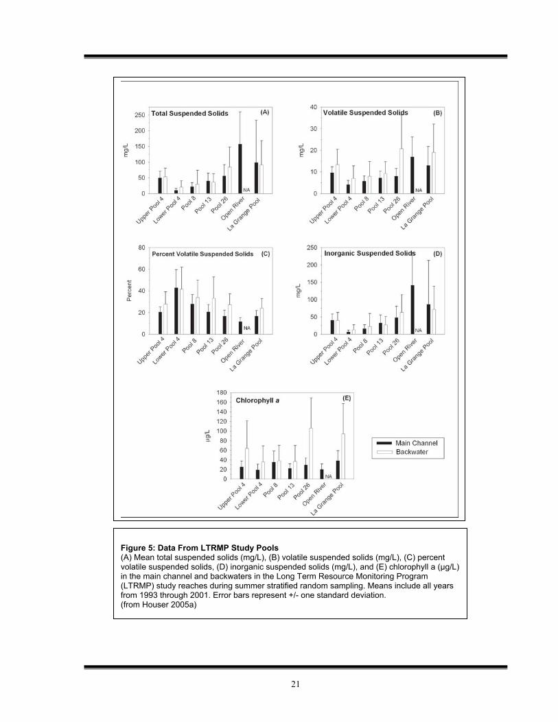
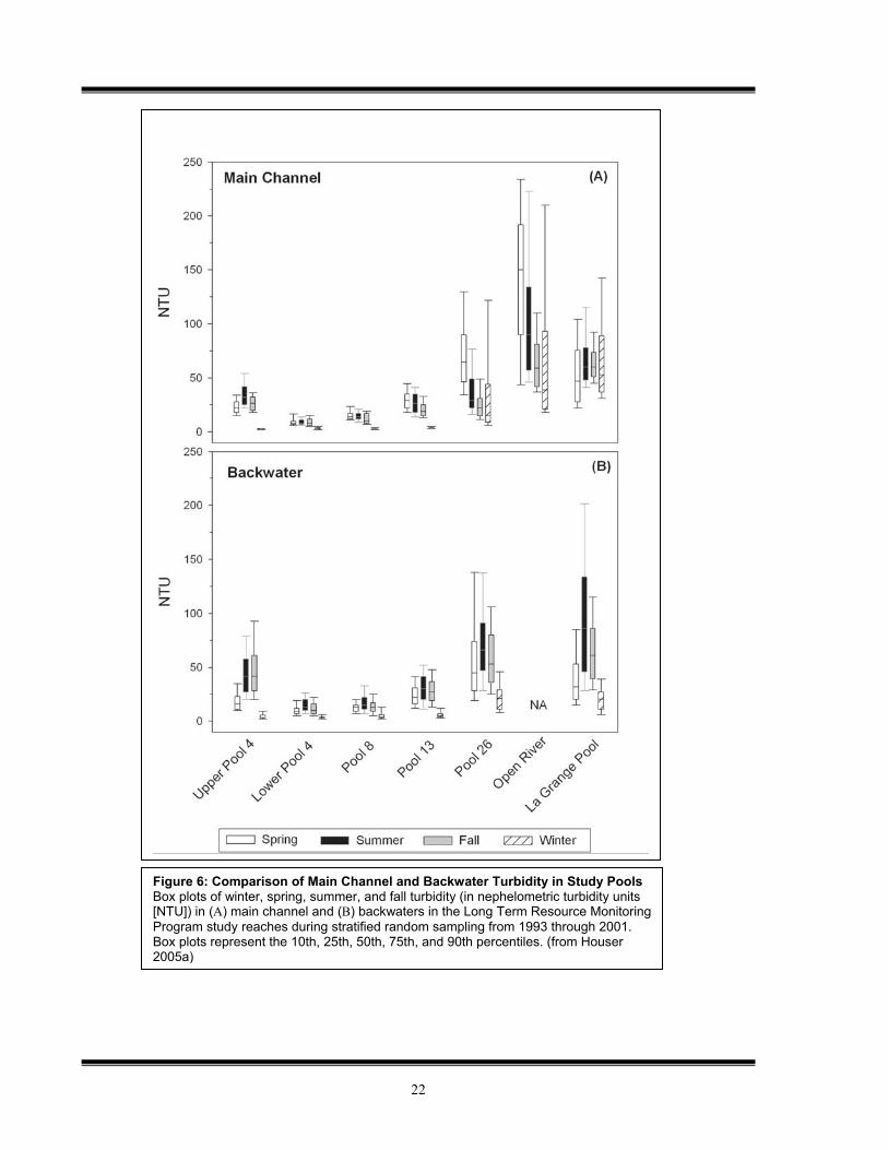
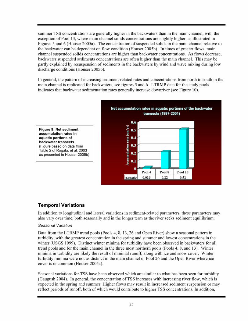
An overall increase in TSS observed in the five Long Term Resource Monitoring Program (LTRMP) study pools from lower Pool 4 to the Open River is most likely attributable to the cumulative impacts of tributary inputs and increased discharge (Houser 2005a). See Figures 5, 6 and 7 on the following pages for a presentation of the LTRMP data regarding TSS and related parameters. Note that the five LTRMP study pools are: Pool 4, Pool 8, Pool 13, Pool 26, and the Open River.
Figure 3: TSS by Eight Digit HUC Reaches (from UMRCC/EPA as modified by Sullivan 2006)
Figure 4: TSS by Pool (from UMRCC/EPA as modified by Sullivan 2006)
21
Figure 5: Data From LTRMP Study Pools (A) Mean total suspended solids (mg/L), (B) volatile suspended solids (mg/L), (C) percent volatile suspended solids, (D) inorganic suspended solids (mg/L), and (E) chlorophyll a (µg/L) in the main channel and backwaters in the Long Term Resource Monitoring Program (LTRMP) study reaches during summer stratified random sampling. Means include all years from 1993 through 2001. Error bars represent +/- one standard deviation. (from Houser 2005a)
22
Figure 6: Comparison of Main Channel and Backwater Turbidity in Study Pools Box plots of winter, spring, summer, and fall turbidity (in nephelometric turbidity units [NTU]) in (A) main channel and (B) backwaters in the Long Term Resource Monitoring Program study reaches during stratified random sampling from 1993 through 2001. Box plots represent the 10th, 25th, 50th, 75th, and 90th percentiles. (from Houser 2005a)
23
Sediment Contribution from Tributaries
As noted above, the cumulative contribution of sediment from tributaries increases as the UMR runs from north to south. Below are further specifics regarding the impacts from certain tributaries.
Effect of the Minnesota River. The Minnesota River is the major source of TSS in the upper portion of the UMR and contributes to elevated concentrations from its confluence with the UMR to Upper Lake Pepin (UMRCC 2002).
Impact of the Missouri River. The Missouri River Basin contains highly erodible soils and the Missouri River has long been a major source of sediment for the Mississippi River. The highest TSS concentrations (> 500 mg/L) in the UMR are found below Lock and Dam 26 and can be attributed in large part to turbid inflows from the Illinois and Missouri rivers (UMRCC 2002). However, the contribution from the Missouri River has declined from historic highs due to dam construction and resulting sediment retention. Additionally, flows increase by nearly 50 percent below the UMR’s confluence with the Missouri River. Because of these influences from the Missouri River, the Unimpounded Reach below St. Louis differs significantly from the rest of the UMR (USGS 1999).
Other tributaries. Other tributaries contributing significant sediment loads to the UMR include the Des Moines, Illinois, Iowa, and Skunk Rivers (Nakato 2005).
Role of Lake Pepin as a “Sediment Trap”
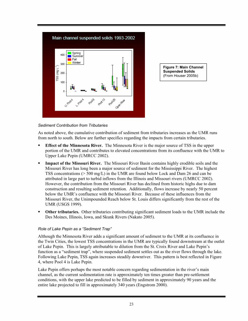
Although the Minnesota River adds a significant amount of sediment to the UMR at its confluence in the Twin Cities, the lowest TSS concentrations in the UMR are typically found downstream at the outlet of Lake Pepin. This is largely attributable to dilution from the St. Croix River and Lake Pepin’s function as a “sediment trap”, where suspended sediment settles out as the river flows through the lake. Following Lake Pepin, TSS again increases steadily downriver. This pattern is best reflected in Figure 4, where Pool 4 is Lake Pepin.
Lake Pepin offers perhaps the most notable concern regarding sedimentation in the river’s main channel, as the current sedimentation rate is approximately ten times greater than pre-settlement conditions, with the upper lake predicted to be filled by sediment in approximately 90 years and the entire lake projected to fill in approximately 340 years (Engstrom 2000).
Figure 7: Main Channel Suspended Solids (From Houser 2005b)
24
Changing Soil and Sediment Characteristics
Suspended sediment particle sizes decrease in a downstream gradient, partly because the sediments coming into the river have smaller particle sizes, and partly because the impoundments on the river cause the larger particles to settle out. Upstream of Lock & Dam 13, tributary sediment loads tend to be coarser and lower, because the watershed soils are more sandy and the watersheds are forested (USGS 1999). However, downstream of Lock & Dam Pool 13, tributary sediment loads tend to be higher and primarily made up of smaller more easily suspended particle sizes because the watershed soils are primarily easily erodible loess soils that are intensively farmed (USGS 1999). Distinct River Segments: Upper Impounded, Lower Impounded, and Unimpounded Reaches
As evidenced by the above descriptions, significant changes in the nature of the river take place at Pool 13 and at Pool 26 (confluence with Missouri River and location of the last lock and dam). The three segments of the river created when these breakpoints are considered have been referred to as the Upper Impounded Reach (Pools 1-13), Lower Impounded Reach (Pools 14-26) and the Unimpounded Reach (St. Louis to Ohio River) (USGS 1999). Within-Pool Variation
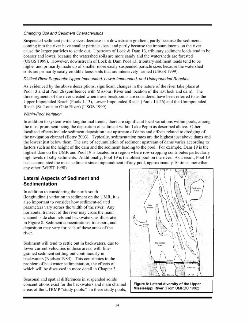
In addition to system-wide longitudinal trends, there are significant local variations within pools, among the most prominent being the deposition of sediment within Lake Pepin as described above. Other localized effects include sediment deposition just upstream of dams and effects related to dredging of the navigation channel (Berry 2003). Typically, sedimentation rates are the highest just above dams and the lowest just below them. The rate of accumulation of sediment upstream of dams varies according to factors such as the height of the dam and the sediment loading to the pool. For example, Dam 19 is the highest dam on the UMR and Pool 19 is located in a region where row cropping contributes particularly high levels of silty sediments. Additionally, Pool 19 is the oldest pool on the river. As a result, Pool 19 has accumulated the most sediment since impoundment of any pool, approximately 10 times more than any other (WEST 1998). Lateral Aspects of Sediment and Sedimentation In addition to considering the north-south (longitudinal) variation in sediment on the UMR, it is also important to consider how sediment-related parameters vary across the width of the river. Any horizontal transect of the river may cross the main channel, side channels and backwaters, as illustrated in Figure 8. Sediment concentrations, transport, and deposition may vary for each of these areas of the river. Sediment will tend to settle out in backwaters, due to lower current velocities in those areas, with fine-grained sediment settling out continuously in backwaters (Nielsen 1984). This contributes to the problem of backwater sedimentation, the effects of which will be discussed in more detail in Chapter 3. Seasonal and spatial differences in suspended solids concentrations exist for the backwaters and main channel areas of the LTRMP “study pools.” In these study pools,
Figure 8: Lateral diversity of the Upper Mississippi River (From UMRBC 1982)
BackwaterLake
ImpoundedArea
25
summer TSS concentrations are generally higher in the backwaters than in the main channel, with the exception of Pool 13, where main channel solids concentrations are slightly higher, as illustrated in Figures 5 and 6 (Houser 2005a). The concentration of suspended solids in the main channel relative to the backwater can be dependent on flow condition (Houser 2005b). In times of greater flows, main channel suspended solids concentrations are higher than backwater concentrations. As flows decrease, backwater suspended sediments concentrations are often higher than the main channel. This may be partly explained by resuspension of sediments in the backwaters by wind and wave mixing during low discharge conditions (Houser 2005b). In general, the pattern of increasing sediment-related rates and concentrations from north to south in the main channel is replicated for backwaters, see figures 5 and 6. LTRMP data for the study pools indicates that backwater sedimentation rates generally increase downriver (see Figure 10). Temporal Variations In addition to longitudinal and lateral variations in sediment-related parameters, these parameters may also vary over time, both seasonally and in the longer term as the river seeks sediment equilibrium. Seasonal Variation
Data from the LTRMP trend pools (Pools 4, 8, 13, 26 and Open River) show a seasonal pattern in turbidity, with the greatest concentration in the spring and summer and lowest concentrations in the winter (USGS 1999). Distinct winter minima for turbidity have been observed in backwaters for all trend pools and for the main channel in the three most northern pools (Pools 4, 8, and 13). Winter minima in turbidity are likely the result of minimal runoff, along with ice and snow cover. Winter turbidity minima were not as distinct in the main channel of Pool 26 and the Open River where ice cover is uncommon (Houser 2005a). Seasonal variations for TSS have been observed which are similar to what has been seen for turbidity (Gaugush 2004). In general, the concentration of TSS increases with increasing river flow, which is expected in the spring and summer. Higher flows may result in increased sediment suspension or may reflect periods of runoff, both of which would contribute to higher TSS concentrations. In addition,
Figure 9: Net sediment accumulation rates in aquatic portions of backwater transects (Figure based on data from Table 2 of Rogala, et al. 2003 as presented in Houser 2005b)
26
stream bank erosion in many tributaries can contribute large loading of TSS to the river during high flow events. Sediment Equilibrium
It does not appear that the UMR has yet attained a sediment equilibrium following its modification for navigation and flood control. The sediment characteristics of the UMR remain dynamic as the river seeks equilibrium following these modifications. A number of studies have indicated that there may be a general trend toward less suspended sediment and slower sedimentation rates for the river overall (USGS 1999, Rogala 1996, Nakato 2005). If this is the case, it would be a pattern consistent with what has been seen on other disturbed river systems, where change is greatest following the initial disturbance and tapers off as a new equilibrium is reached (USGS 1999). However, there is some evidence that, on a year-to-year basis, individual pools can be dynamic and demonstrate either a net sediment accumulation or loss (Gaugush 2004). While it is difficult to forecast exactly when each navigation pool on the UMR will reach a new sediment equilibrium, it appears that – without intervention – the pools in general will continue to progress toward shallow, more uniform, and less ecologically diverse conditions (USGS 1999). As noted earlier, Lake Pepin and Pool 19 may be the most dramatic examples of this sedimentation process. Therefore, it is important to note that even if sediment transport and deposition processes are slowing, they may still be creating adverse impacts and leading to a future condition of impaired ecological integrity. Ecological consequences could include poorer water quality, poorer substrate quality, the reduction of submersed aquatic plant and benthic invertebrate populations, less diverse fish communities, and fewer areas that can support migratory waterfowl (USGS 1999). These impacts are addressed in more detail in Chapter 3. Limitations of Data and Information Regarding Sediment In considering sediment on the UMR, the information limitations faced in addressing such a large and diverse resource must be acknowledged. Among these limitations are: There is currently insufficient sedimentation rate information and bathymetry data on the river to
allow sediment aggradation and degradation rates to be comprehensively estimated, particularly in backwater areas. Monitoring results from the five LTRMP study pools are becoming available, but this is not a complete data set for all pools. There is a need to develop a general sediment-budget analysis tool and conduct detailed pool-by-pool sediment budget analyses (Gaugush 2004, Nakato 2005).
The present lack of sediment studies limits the ability to evaluate and predict the fate of backwaters systemically (USGS 1999).
Movement of sediment in the river and the effects of the dams on this movement are complex and poorly understood (USGS 1999).
Spatial patterns associated with sedimentation are difficult to generalize from one place to another. Site specific data will probably always be necessary when determining what kinds of alternatives exist to minimize a sedimentation problem (Lubinski 1993).
The high variability in accumulation rates among and along transects illustrates the complexity of sediment erosion, transport, and deposition in the Upper Mississippi River. Simply applying a uniform rate across backwaters and pools will not provide adequate estimates of the accumulation rates needed to project future conditions (Rogala 1996).
27
Summary, Unknowns, and Implications Regarding Sediment Sources, Transport, and Deposition on the UMR Summary
Sediment sources for the UMR main stem include both landscape (erosion, runoff) as well as in-stream (re-suspension, bank erosion) contributions. Significant sediment contributions enter the main stem from UMR tributaries.
The modification of the UMR for navigation and flood control has significantly altered the transport and deposition of sediment on the UMR.
There is a notable increase in sediment and sediment-related parameters as the river travels from north to south, which results primarily from the accumulated sediment contributions of UMR tributaries.
There are sediment variations across the width of the river between the main channel, side channels and backwaters. Additionally, sediment concentrations vary over time.
Unknowns
It does not appear that the river has reached sediment equilibrium following the construction of the locks and dams. It is not known when and if the river will reach equilibrium and what equilibrium concentrations of sediment-related parameters will be.
Currently available data does not fully characterize sediment sources, transport, and deposition on the UMR. In particular, information to calculate sediment aggradation and degradation rates is lacking, and sediment budgets have yet to be developed for many UMR pools. Relatively more information is available about suspended sediments (as opposed to bedded sediments), but monitoring agencies employ different measurement approaches, making comparisons difficult. Additionally, while LTRMP research provides valuable data, the gaps between the five LTRMP study pools need to be filled in to create a comprehensive characterization of the UMR.
Implications
Because of the variability in sediment characteristics, it appears that there cannot be a single and broadly applied sediment criterion for the entire river. Criteria must be developed to accommodate longitudinal, latitudinal, and temporal variation in sediment-related parameters, while still being protective of designated uses.
Because data are limited at this time, any sediment-related water quality criteria that are developed may need to be revisited as more data becomes available.

28
29
Chapter 3 Sediment Impacts on Aquatic Life and Other Designated Uses
Background Sediment as a Cause of Impairment Listing
Nationally, sediment has repeatedly been identified as a major cause of waterbody impairment (US EPA 2006a). State water quality assessments required under Section 305(b) of the Clean Water Act have consistently listed turbidity, suspended solids, sediment, and siltation as dominant polluting factors in rivers and streams, lakes, reservoirs, ponds, wetlands, and ocean shoreline waters (US EPA 2006b). U.S. EPA’s 2003 document “Strategy for Water Quality Standards and Criteria” states that “sedimentation and siltation problems account for more identified water quality impairments than any other pollutant” (US EPA 2003b). As mentioned in Chapter 1, it may be difficult to broadly interpret the magnitude of impacts associated with these impairment listings, because of the diversity in criteria that the States use to evaluate sediment impairments. Focus on Impacts from Excessive Sediment
Suspended and bedded sediments occur naturally in waterbodies and, in appropriate amounts, are essential to the ecological function of waterbodies (US EPA 2003a). However, an imbalance in sediment can cause detrimental ecosystems impacts. Excessive sediment is a more common sediment imbalance than is sediment deficiency (US EPA 2006b). Effects of excessive sediment are therefore the primary focus of this chapter. However, ecosystem impairments can also be associated with a lack of sediment (see later section on sediment starvation). Focus on Impacts to Aquatic Life Use
States may assign a variety of designated uses, including drinking water, recreation, agricultural water supply, and aquatic life to the waterbodies they regulate. While sediment can affect a number of these designated uses, sediment criteria typically focus on protection of aquatic life because: 1) when sediments diminish the quality of aquatic life by degrading habitat, other uses such as recreational or commercial fishing are likely to be impacted and 2) there is evidence that aquatic life uses are one of the most sensitive endpoints of altered sediment supply. Therefore aquatic organisms may provide an early warning of potential sediment impacts for a wide range of uses, and prompt action may prevent these other uses from being impacted (US EPA 2006b). Accordingly, the discussion throughout the rest of this chapter will focus primarily on impacts to the aquatic life use. Note that this chapter describes “aquatic life” in a very broad sense, including vertebrates, invertebrates, and plants, as well as the ecosystem overall. Individual States may have definitions of their aquatic life use that do not necessarily incorporate all of these components.
Research Question: What are the documented, and expected, impacts of sediments and sedimentation on aquatic life in the UMR?
30
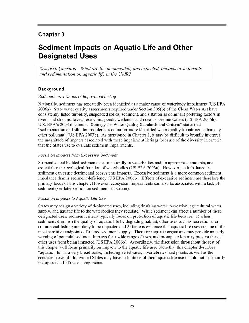
General Overview of Sediment Impacts on Aquatic Life In general, sediment can affect aquatic ecosystems in two ways: 1) direct effects on biota, and 2) effects on physical habitat that result in effects on biota (US EPA 2003a). Also, across aquatic life types, early life stages (eggs, larva, juvenile, new plant shoots, etc.) are generally the most sensitive to sediment effects (Watson and Der 1986). Figure 11 summarizes the ecological effects of excessive suspended and bedded sediments. Following the figure is a more detailed discussion of the impacts of excessive sediments (both suspended and bedded) on specific organisms and ecosystem elements.
Figure 10: Ecological effects of excessive suspended and bedded sediments (From W. Munns, EPA as displayed in EPA 2006b.)
Ecological Effects of Excessive SABS Suspended Sediments Bedded Sediments
Decreased light penetration reduces primary productivity.
In large amounts, bedded sediments can bury and smother infaunal or epibenthic organisms and demersal eggs. Increased turbidity reduces visual acuity and
capture success for predators and foragers, stimulates drifting behavior in macroinvertebrates, reduces habitat suitability and habitat range for organisms that require clear water. At high levels, suspended sediment can clog and abrade filtration and respiratory organs.
In smaller amounts, excess fine sediments can fill in gaps between larger substrate particles, embedding the larger particles and eliminating interstitial spaces that would otherwise be used as habitat for reproduction, feeding, and refugia for invertebrates and fish.
31
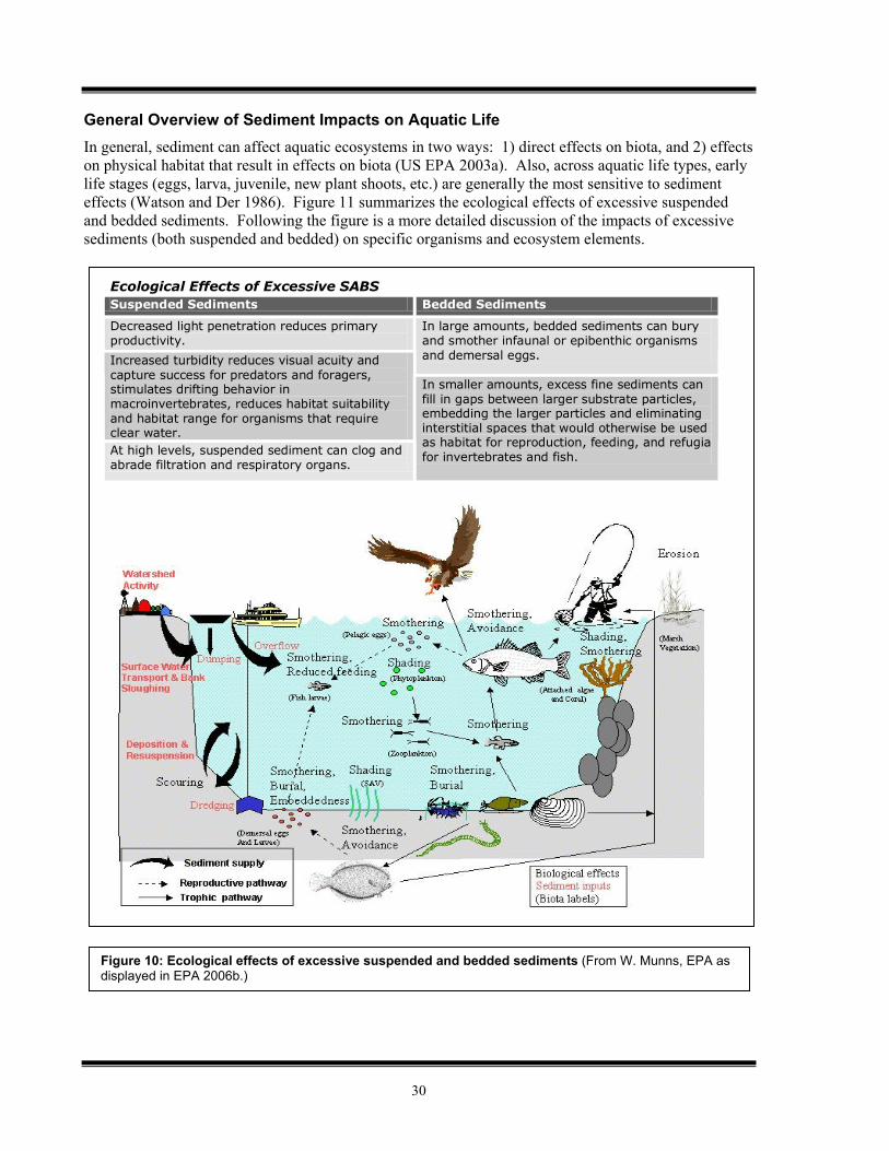
Figure 11: Relationship of Fish Activity and Turbidity Schematic adapted from "Turbidity: A Water Quality Measure", Water Action Volunteers, Monitoring Factsheet Series, UW-Extension, Environmental Resources Center.
A generic, un-calibrated impact assessment model based on Newcombe, C. P., and J. O. T. Jensen. 1996. Channel suspended sediment and fisheries: a synthesis for quantitative assessment of risk and impact. North American Journal of Fisheries Management. 16: 693-727.
(Obtained from: http://waterontheweb.org/under/waterquality/turbidity.html)
Effects on Fish
In general, the effects of sediment on fish can be grouped into the following major categories: 1) direct physiological effects of suspended sediment, 2) indirect effects due to decreases in water clarity, and 3) indirect effects due to sediment deposition (Berry 2003). These effects can be summarized as follows (from EIFAC 1965, U.S. EPA 1999, UMRBA 2004, UMRCC 2003, U.S. EPA 2004 and Berry 2003): Direct Physiological Effects of Suspended Sediment
o Clogged gills and damage caused by abrasion. o Reduced respiration efficiency as a result of gill clogging and damage. o Increased coughing rates.
Effects Due to Decreases in Water Clarity o Reduced prey availability for sight-feeding species as decreased visibility makes it more
difficult for fish to locate prey. This effect may be greatest on larval fish, as larger fish may be able to reduce some of these effects by avoiding low visibility water.
o Modifications to the natural movements and migrations of fish as they seek less turbid water.
o Shifts in fish communities to turbidity-tolerant species.
Effects Due to Sediment Deposition o Spawning habitat elimination due to changes from coarse to fine substrates. o Smothering and reduced hatching of eggs. In particular, demersal eggs may be particularly
vulnerable as only a few millimeters of deposited sediment may prevent them from hatching due to lack of oxygen.
o Reduced larval survival due to armoring of the sediment surface, which traps the larvae. o Filling in of rearing pools, which results in reduced cover from predators, as well as
temperature modification. Both the degree of exposure and the duration of the exposure must be considered when assessing sediment impacts to fish. Severity of impact increases along with increasing degree and duration (Berry 2003). Figure 12 gives a generalized presentation of predicted impact to fish with increasing degree and duration of exposure to suspended sediments. Sensitivity also varies by fish species and life stage, with adults typically being most tolerant (Muncy 1979).
32
Effects on Invertebrates Changes in the quality and quantity of deposited sediments can impact the structure and function of invertebrate communities both by increasing substrate embeddedness as well as altering substrate particle size distributions (Berry 2003). Additionally, suspended sediments can interfere with the respiration and ingestion mechanisms of invertebrates such as mussels and insect larvae. These effects on invertebrates need to be considered in terms of both the direct impacts on the organisms themselves and the potentially resulting impacts on higher levels in the food chain, especially in regard to the dependence of freshwater fisheries on benthic invertebrate productivity (Berry 2003). Potential impacts on mussels and other invertebrates follow (summarized from Berry 2003, Duyvejonck 2005 and Burdis 2006): Effects on Mussels
o Clogging and abrasion to filtration mechanisms. o Increased respiration rates and impaired ingestion rates due to clogging and abrasion of
filtration mechanisms. o Ingestion of contaminants adhered to sediment particles, and resulting impacts and/or
bioaccumulation. o Burial, if sedimentation rates are high, such as occur during floods.
Effects on Other Invertebrates o Adverse impacts on insect larvae respiration. o Decreases in aquatic insect densities due to increased embeddedness. o Adverse impacts on caddisfly pupa survival due to increases in siltation. o Increased invertebrate drift and resulting changes in the distribution of benthic
invertebrates. o Increased predation of benthic invertebrates, as result of invertebrate drift.
Effects on Plants
Increases in suspended sediments can directly impact aquatic vegetation by reducing the light available to these plants, which results in a suppression of photosynthesis (Berry 2003). As with invertebrates, both the direct impacts to the vegetation and resulting ecosystem impacts are of concern. A reduction in primary productivity may adversely impact consumers higher up on the food chain, and the loss of aquatic vegetation can affect the integrity of the aquatic ecosystem by reducing substrates for invertebrates, cover for fish, and food for water fowl (Duyvejonck 2005). A summary of sediment effects on aquatic vegetation follows (from Muncy 1979, Berry 2003, and Duyvejonck 2005): Suppression of photosynthesis, resulting from reduced available light. Resulting effects from reduced photosynthesis include:
o Limited growth and distribution of aquatic plants. o Decreased seed/tuber production. o Decreased survival rates. o Decline in plankton algae, which is a primary food supply for larval fishes.
Suspended sediments can hamper re-establishment of plant beds lost to catastrophic events. Plants in silt substrates are prone to uprooting from waves.
Effects on Other Wildlife
While some other aquatic-dependent wildlife (such as birds and mammals) may have trouble hunting in turbid water, they are generally able to relocate to avoid increased turbidity, especially short term increases. As a result, they can avoid most of the direct effects of increased suspended and bedded sediments. Also, as noted above, a loss of aquatic vegetation caused by reduced photosynthetic activity
33
can reduce the food supply available for waterfowl. However, there are not many studies available on the effects of sediments on aquatic-dependent wildlife (Berry 2003). Sediment Starvation
Although the preceding discussion has focused on problems associated with excessive sediment, it should be noted that “sediment starvation” – a reduction of the natural sediment load, as may occur downstream from dams – can also be problematic. Sediment starvation can result in loss of native fish species, riparian ecosystems, and wetlands (U.S. EPA 2003). Limitations in Knowledge
In reviewing the potential effects of sediments on aquatic ecosystems, it is important to keep in mind that knowledge regarding these effects is limited, and much remains to be determined regarding these impacts. While anecdotal evidence is widely available, there appear to be few directed studies that relate specific levels of sediment (suspended or bedded) over specific durations, to specific effects on aquatic organisms. In a 2003 literature review of the biological effects of sediments, Berry et al. cataloged the shortcomings of current knowledge in this area (Berry 2003). The following is a summary of their observations regarding limits in knowledge regarding sediments: The effects of sediments on aquatic life are complicated, and unraveling them may be difficult. The effects of sediments on receiving water ecosystems are complex and multi-dimensional, and
further compounded by the fact that sediment flux is a natural and vital process for aquatic systems. The literature on suspended sediment is larger and better summarized than that for bedded sediment. Even within habitats there may be great variation in the effects of sediments. There is little hard evidence in the literature that species from different habitats have different
sediment requirements. This is largely because there have been very few studies that compare species from different habitats in the same study, and given the wide range of experimental designs used in the literature it is very difficult to make comparisons between studies.
Summarizing effects data for sediments is difficult for several reasons. One reason is that there is not one agreed-upon measurement for sediments (for either suspended or bedded sediments). Another reason is that summarizing effects data for sediments is difficult in that there are no standard durations for sediment effects testing.
The limitations in knowledge are primarily associated with specific questions regarding how much sediment creates an effect, how long must the sediment be present to have an impact, and whether these effects are actually occurring on the UMR (see next section). Impacts on Other Uses
Sediments can also impact designated uses beyond aquatic life use. Suspended solids and turbidity can affect industrial and municipal water supply uses by fouling treatment systems, as well as increasing the cost and difficulty of treatment. Finished drinking water must have a turbidity value of less than 1 NTU to allow for effective disinfection, because suspended solids provide areas where microorganisms are not in contact with the chlorine disinfectant (NAS 1974). Turbidity and suspended solids can also similarly affect industrial processes. Generally, the more turbidity or suspended matter that must be removed from raw water for industrial or municipal use, the greater the expense associated with use of the raw water. Turbid water also affects recreational and aesthetic enjoyment of water. Turbid waters can be dangerous for swimming due to the possibility of unseen submerged hazards, and the difficulty in locating swimmers in danger of drowning (NAS 1974).
34
Aquatic Life Impacts on the UMR While it is useful to consider the general potential impacts of sediments described in the previous section, in the context of this report it is even more important to consider what is known and documented regarding sediment impacts on the UMR. Numerous publications refer to sediment as a leading environmental problem on the UMR (UMRBA 1984, UMRBA 1993, Lubunski 1993, UMRCC 2000, USFWS 2006) and a recent LTRMP report stated that turbidity and suspended solids concentrations in the UMRS “are sometimes at levels that negatively affect aquatic organisms” (Houser 2005a). However, direct linkages between specific sediment occurrence and specific aquatic life impacts may be difficult to establish (US EPA 2003c), particularly to the degree which would trigger a Clean Water Act impairment categorization. The primary questions regarding sediment-related aquatic life use impacts on the UMR appear to be: do impacts occur? when and where? what organisms are affected? how severe are the impacts? how are the impacts related to Clean Water Act listings? can impacts be addressed as long as the river is managed for navigation?
The following is a summary regarding known and expected impacts from sediment on the ecosystem and specific species of the UMR. Ecosystem Impacts
Backwater Sedimentation The most frequently cited sediment-related ecosystem impact on the UMR is the sedimentation of backwaters (UMRBC 1982, UMRBA 1984, UMRBA 1993, Lubinski 1993, Rogala 1996, USGS 1999, UMRCC 2000, and USFWS 2006). These backwaters, including backwater lakes, ponds, and sloughs provide valuable fish and wildlife habitat (UMRBA 1984, UMRBA 1993). Fine grained sediment has a tendency to settle in backwaters and side channels where the water velocity and turbulence is insufficient to hold the solids in suspension (Lubinski 1993, UMRBA 1984). The accumulation of sediment in backwaters can result in destruction of spawning beds, alteration of habitat areas, decreased light penetration to plants, and the filling in of shallow areas. The long term result of filling in of backwaters is a succession of ecological communities, a loss of habitat diversity, reduction of submersed aquatic plant and benthic invertebrate populations, less diverse fish communities, and fewer areas that can support migratory waterfowl (UMRBC 1982, UMRBA 1993, Bhowmik 1993, Lubinski 1993, USGS 1999, Duyvejonck 2005). Effects of backwater sedimentation appear to be greatest in the lower river reaches and less pronounced on the upper impounded reach (USGS 1999). There is some evidence that backwater sedimentation rates may be slowing or lower than previously predicted (Rogala 1996) and that this may be part of the river reaching a more permanent equilibrium. However, it is uncertain how long it will take for the river to reach equilibrium (USGS 1999). There is still degradation of habitat occurring from sedimentation, and the new equilibrium may be one of slower sedimentation rates, but overall lower habitat quality (Lubinski 1993, USGS 1999). Therefore, backwater sedimentation remains a predominant sediment-related aquatic life concern on the UMR.
35
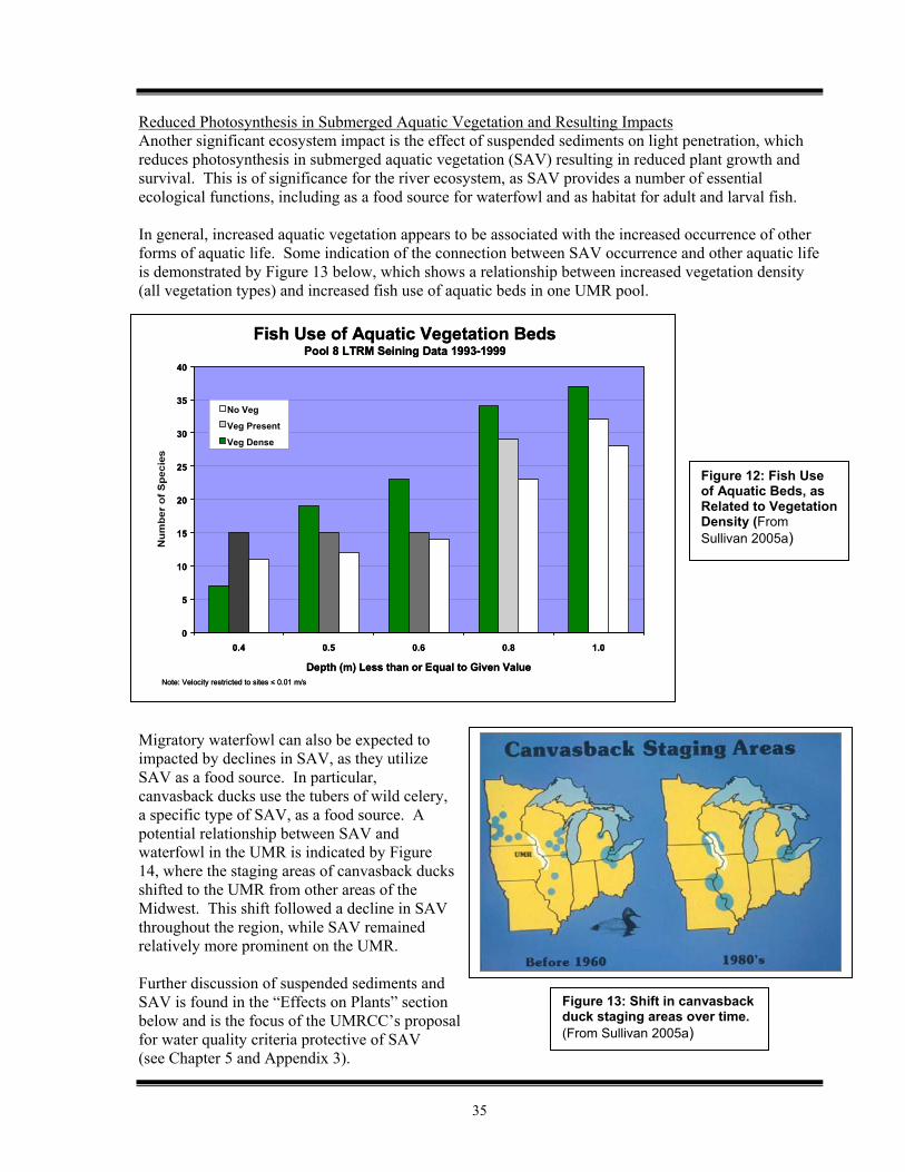
Reduced Photosynthesis in Submerged Aquatic Vegetation and Resulting Impacts Another significant ecosystem impact is the effect of suspended sediments on light penetration, which reduces photosynthesis in submerged aquatic vegetation (SAV) resulting in reduced plant growth and survival. This is of significance for the river ecosystem, as SAV provides a number of essential ecological functions, including as a food source for waterfowl and as habitat for adult and larval fish. In general, increased aquatic vegetation appears to be associated with the increased occurrence of other forms of aquatic life. Some indication of the connection between SAV occurrence and other aquatic life is demonstrated by Figure 13 below, which shows a relationship between increased vegetation density (all vegetation types) and increased fish use of aquatic beds in one UMR pool. Migratory waterfowl can also be expected to impacted by declines in SAV, as they utilize SAV as a food source. In particular, canvasback ducks use the tubers of wild celery, a specific type of SAV, as a food source. A potential relationship between SAV and waterfowl in the UMR is indicated by Figure 14, where the staging areas of canvasback ducks shifted to the UMR from other areas of the Midwest. This shift followed a decline in SAV throughout the region, while SAV remained relatively more prominent on the UMR. Further discussion of suspended sediments and SAV is found in the “Effects on Plants” section below and is the focus of the UMRCC’s proposal for water quality criteria protective of SAV (see Chapter 5 and Appendix 3).
0
5
10
15
20
25
30
35
40
1.00.80.60.50.4
Depth (m) Less than or Equal to Given Value
No Veg
Veg Present
Veg Dense
Note: Velocity restricted to sites < 0.01 m/s
Fish Use of Aquatic Vegetation BedsPool 8 LTRM Seining Data 1993-1999
0
5
10
15
20
25
30
35
40
1.00.80.60.50.4
Depth (m) Less than or Equal to Given Value
No Veg
Veg Present
Veg Dense
Note: Velocity restricted to sites < 0.01 m/s
Fish Use of Aquatic Vegetation BedsPool 8 LTRM Seining Data 1993-1999
Figure 12: Fish Use of Aquatic Beds, as Related to Vegetation Density (From Sullivan 2005a)
Figure 13: Shift in canvasback duck staging areas over time. (From Sullivan 2005a)
36
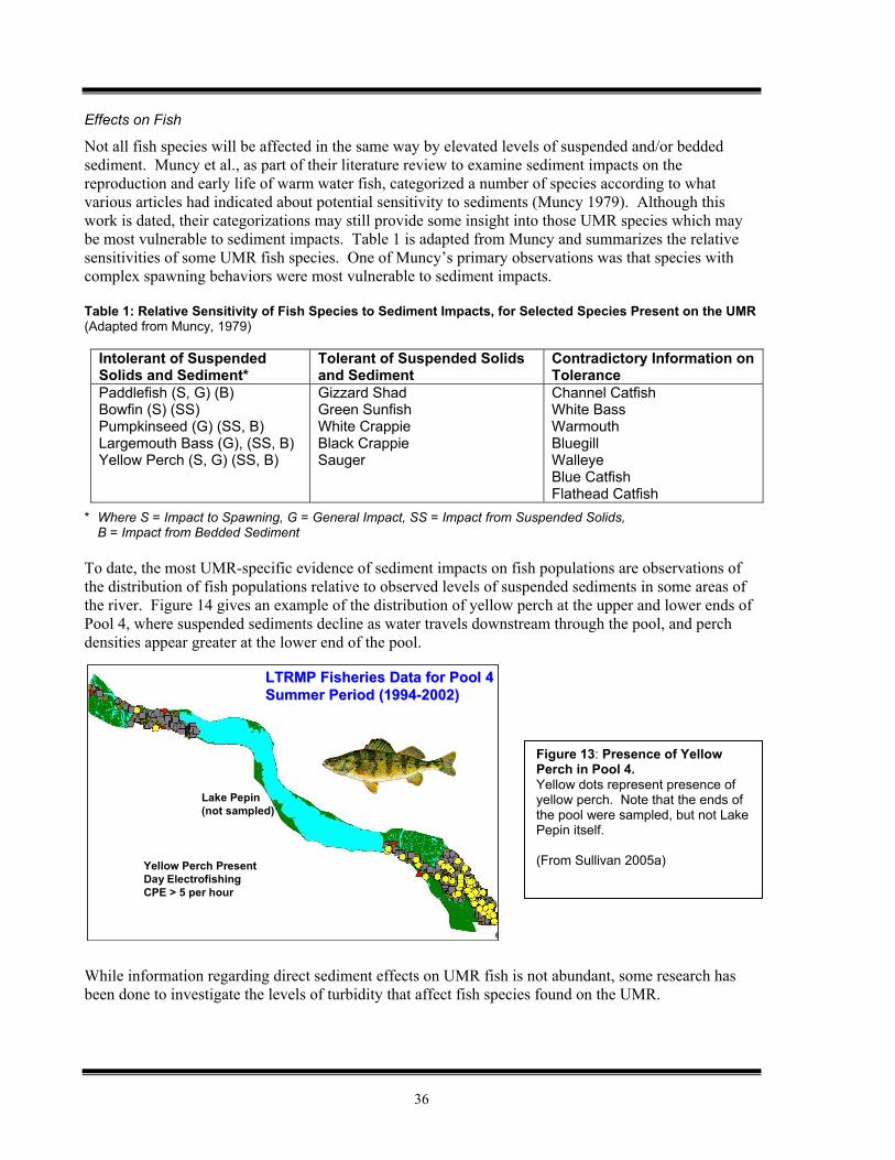
Effects on Fish
Not all fish species will be affected in the same way by elevated levels of suspended and/or bedded sediment. Muncy et al., as part of their literature review to examine sediment impacts on the reproduction and early life of warm water fish, categorized a number of species according to what various articles had indicated about potential sensitivity to sediments (Muncy 1979). Although this work is dated, their categorizations may still provide some insight into those UMR species which may be most vulnerable to sediment impacts. Table 1 is adapted from Muncy and summarizes the relative sensitivities of some UMR fish species. One of Muncy’s primary observations was that species with complex spawning behaviors were most vulnerable to sediment impacts. Table 1: Relative Sensitivity of Fish Species to Sediment Impacts, for Selected Species Present on the UMR (Adapted from Muncy, 1979)
Intolerant of Suspended Solids and Sediment*
Tolerant of Suspended Solids and Sediment
Contradictory Information on Tolerance
Paddlefish (S, G) (B) Bowfin (S) (SS) Pumpkinseed (G) (SS, B) Largemouth Bass (G), (SS, B) Yellow Perch (S, G) (SS, B)
Gizzard Shad Green Sunfish White Crappie Black Crappie Sauger
Channel Catfish White Bass Warmouth Bluegill Walleye Blue Catfish Flathead Catfish
* Where S = Impact to Spawning, G = General Impact, SS = Impact from Suspended Solids, B = Impact from Bedded Sediment
To date, the most UMR-specific evidence of sediment impacts on fish populations are observations of the distribution of fish populations relative to observed levels of suspended sediments in some areas of the river. Figure 14 gives an example of the distribution of yellow perch at the upper and lower ends of Pool 4, where suspended sediments decline as water travels downstream through the pool, and perch densities appear greater at the lower end of the pool. While information regarding direct sediment effects on UMR fish is not abundant, some research has been done to investigate the levels of turbidity that affect fish species found on the UMR.
Figure 13: Presence of Yellow Perch in Pool 4. Yellow dots represent presence of yellow perch. Note that the ends of the pool were sampled, but not Lake Pepin itself. (From Sullivan 2005a)
LTRMP Fisheries Data for Pool 4LTRMP Fisheries Data for Pool 4Summer Period (1994Summer Period (1994--2002)2002)
Yellow Perch PresentDay ElectrofishingCPE > 5 per hour
Lake Pepin(not sampled)
LTRMP Fisheries Data for Pool 4LTRMP Fisheries Data for Pool 4Summer Period (1994Summer Period (1994--2002)2002)
Yellow Perch PresentDay ElectrofishingCPE > 5 per hour
Lake Pepin(not sampled)
37
Marking, et al. examined the impact of various levels and compositions of suspended sediments on a number of UMR fish species. The most sensitive response they identified was that of walleye eggs to suspended silt sediment, where continuous exposure to 50 mg/l of this sediment type produced significant mortality in eggs. However, for other species and other coarse sediment compositions, much higher concentrations were needed to produce mortality in eggs, fry, and juveniles (Marking 1984). Turbidity levels of 60 NTU for bluegills, 70 NTU for largemouth bass, and 100 NTU for walleye have been shown to interfere with feeding and prey capture (Gardner 1981, Reid et al.1999, Vandenbyllaardt et al. 1991). These three fish species have historically been found throughout the UMR and still exist in the UMR (Burdis, 2006). LTRMP data has identified turbidity at or above these levels in the main channel of Pool 26, the Open River, and backwaters of Upper Pool 4 and Pool 26, during at least some parts of the year (Houser 2005a). Therefore, while there has not been extensive examination of the correlation between specific suspended sediment occurrence and impacts on UMR fish populations, turbidity levels in some portions of the UMR appear to exceed the levels documented to affect fish feeding rates, prey capture, and potentially fish reproduction (depending on the composition of the sediment). Sedimentation is also of significance for fish populations on the UMR because, as noted above, deposition of sediment in backwaters can lead to the loss of backwater spawning beds and contribute to reduced overall fish species diversity. Also, as discussed previously, declines in SAV from reduced light penetration and photosynthesis can reduce available fish habitat. Overall, it appears appropriate to conclude that sediment is likely impacting some fish species in certain areas of the UMR, or limiting their distribution in the UMR. However, the specific effects on individual species need to be more clearly defined and aligned with resource mangers’ goals for species diversity and distribution on the UMR. Effects on Invertebrates Mussels The most dramatic potential sediment-related impact to mussels on the UMR is simply the burial of mussel beds. This effect was likely most pronounced in the time period immediately following construction of the dams on the UMR, as sediment was deposited in the lower reaches of the navigational pools when the velocity of water was slowed by the dams. As discussed earlier, sediment accumulation is still occurring in backwaters, and may be especially problematic in other slow flowing areas and tributary inflows (USGS 1999). In these areas, mussels may still be vulnerable to direct burial or smothering. Flood conditions may also introduce large amounts of sediment, which can lead to burial (Burdis 2006). A more subtle, yet ongoing, impact of sedimentation is the alteration of the composition of the river bed inhabited by the mussels. Sediment can fill the interstitial spaces between larger bed materials, inhibiting water flow and the makeup of algal communities. Some mussels are able to survive in this modified habitat, but others are not. Juvenile mussels may be most susceptible to these changes in habitat (USGS 1999). Suspended sediment may also interfere with the ingestion and respiration processes of UMR mussels, as generally described in the preceding section. Additionally, there is the possibility that, if host fish for mussel larvae are impacted adversely by sediment, mussel reproduction may be impaired.
38
Effects on Plants
Submerged Aquatic Vegetation
A primary effect of sediment on plant life in the UMR is the impact of suspended sediment on the growth of submerged aquatic vegetation (SAV) and on its ability to recover from decline or injury. SAV is most abundant in the upper reaches of the UMR, from Pools 4 to Pool 13 (USGS 1999), and provides a variety of ecosystem benefits including: 1) leaves, seeds, and tubers as food source for waterfowl, 2) substrate for invertebrate colonization, 3) habitat for larval and adult fish, and 4) sediment stabilization (UMRCC 2003). The presence of excess suspended sediments reduces light penetration to SAV, which in turn inhibits photosynthesis and is detrimental to plant growth and health. Other mechanisms by which sediments can impact SAV include the settling of sediment on the leaves of SAV and excessive sedimentation potentially leading to the burial of plants (USGS 1999). Suspended sediments have been considered a contributing factor in the decline of SAV observed on the UMR in the late 1980s and early 1990s (USGS 1999, Houser 2005a). Turbidity levels of approximately 40 NTU have been found to decrease the growth survival of wild celery, a prominent type of SAV on the UMR (Dolye and Smart 2001). Other laboratory work done by Doyle found a significant negative impact on wild celery growth at sustained turbidity levels of 30 NTU (Doyle 2000). Sago pondweed, another common type of SAV on the UMR, is also adversely impacted by suspended sediments and turbidity, but it does not appear to be as sensitive as wild celery (Doyle 2000). The Upper Mississippi River Conservation Committee has recommended a limit of 20 NTU to support and sustain SAV on the UMR (UMRCC 2003), as discussed in Chapter 5. In addition to restricting the growth and abundance of SAV, excess suspended sediments inhibit the recovery of SAV from periods of decline (USGS 1999). As emphasized in the preceding section, a major concern associated with impacts to SAV are potentially resultant effects on fish and waterfowl populations and population distribution. Considerations of Timing and Duration
While data from the LTRMP and other sources indicate that suspended solids concentrations and turbidity concentrations exist in some areas of the UMR (including upper Pool 4, Pool 26, and the Open River) at levels which may negatively impact aquatic life (Houser 2005a), the duration of these exposures is important to consider in assessing the actual expressed impact. The timing of the exposure to elevated concentrations may also be critical in terms of the life cycle stage in which the exposure to an organism occurs (Newcombe and MacDonald 1991). More work is needed in exploring this relationship of timing and duration to aquatic life impacts on the UMR. Limitations in Knowledge Regarding Aquatic Life Impacts on the UMR
As is the case with sediment impacts on aquatic life in general, much more remains to be learned regarding the impacts of sediments on aquatic life in the UMR. The specific impacts that observed suspended sediment concentrations and sedimentation rates have on aquatic life, particularly vertebrate organisms such as fish and waterfowl, need to be explicitly documented. The lack of direct and specific linkage was cited by US EPA Region 7 and the Iowa DNR in a decision not to list the UMR for sediment impairment in 2002 (US EPA 2003c). More data is becoming available through LTRMP, and other monitoring, which aids in tracking sediment levels that may affect biota. However, further investigations of correlations between observed
39
sediment conditions and impacts on aquatic life could aid in the development of criteria. Paired physical and biological data, which involve selection of targeted physical and biological parameters, may be particularly useful. As noted above, such studies will also need to consider timing and duration of exposure, in addition to simply observing the levels of sediment-related parameters. Summary, Unknowns, and Implications Regarding Impacts on Aquatic Life and Other Designated Uses Summary
A variety of adverse effects to aquatic life can be associated with excessive sediments.
The most commonly cited impacts from sediment on the UMR include backwater sedimentation (and associated detrimental effects on fisheries, waterfowl, and ecosystem diversity), the effect of suspended sediment on submerged aquatic vegetation (and associated detrimental effects on waterfowl and fish populations), as well as the direct impacts of suspended sediments on fish.
Observed suspended sediment levels indicate that adverse impacts to aquatic life use can be expected in some areas of the UMR. Upper Pool 4, Pool 26, and the Open River are the areas where impacts are known to be most likely.
Unknowns
While more information is becoming available, further research is needed to link observed sediment parameters to specific impacts on aquatic life on the UMR, particularly in regard to vertebrates. This may require paired monitoring of physical and biological parameters. Consideration of timing and duration of exposure needs to be taken into account in such studies.
Specific areas where further information gathering or research would be beneficial include: o Explicitly defining linkages between SAV occurrence and populations of fish and
waterfowl. o Further examination of fish species directly impacted by sediments and how their
populations, and population distributions, may vary with concentrations of sediment-related parameters. This examination would take into account both direct effects on fish, as well as impacts on reproductive success due to backwater sedimentation. It would also include establishing the historic and desired ranges for populations of key fish species.
o Determining historic range of SAV occurrence, and desired range for SAV occurrence. o Examining further the relationship between direct and indirect impacts on fish and mussel
populations. This includes specifically identifying important host fish on the UMR, whether they are being impacted by sediments, and related changes in mussel populations.
o Expanding both biological and physical parameter measurements beyond the LTRMP study pools, and analysis of data from non-study pools. This may include examining recently gathered EMAP data.
Implications
Since aquatic life is generally considered a very sensitive designated use, pursuing criteria which protect aquatic life uses will likely protect other designated uses on the UMR.
If sediment-related criteria are developed in the near future, they will likely need to be based on relatively well-defined relationships (such as the impact of suspended sediment on photosynthesis in SAV), as opposed to relationships that have not been as quantitatively defined (such as indirect impacts of sediment on fish, waterfowl, and mussel populations).
In implementing any criteria, States may need to be comfortable operating in an environment of some uncertainty regarding specific effects to aquatic life. In addition, any criteria established may have to be revised to incorporate information from future research.

40
41
Chapter 4 States’ Current Approaches to Sediment on the UMR
States’ Approaches Under the Clean Water Act Under the Clean Water Act (CWA), States address sediment similarly to the way in which other pollutants are addressed. Specifically, this means that the States take the following steps:
1) Set water quality standards, including designated use(s), water quality criteria, and an anti-degradation policy. This includes assigning specific designated uses(s) to a waterbody.
2) Monitor for the presence of a pollutant or indicator of a pollutant in a waterbody. 3) Using monitoring results and other available information, assess the waterbody for support of
the designated use(s) as required under CWA Section 305(b). If the assessment determines the use to be impaired, list the waterbody on the “impaired waters list” as required under CWA Section 303(d).
4) For all identified impaired waters, develop a total maximum daily load (TMDL) or other comprehensive strategy functionally equivalent to a TMDL.
This chapter summarizes the States’ approaches in the steps listed above in regard to sediment, highlighting areas of similarity or difference. Water Quality Standards Water quality standards consist of three parts: 1) designated uses for waterbodies, 2) water quality criteria to protect the uses, and 3) an anti-degradation policy. Designated uses for a waterbody are those uses – such as recreation, aquatic life, and water supply – that a State establishes as the desired function of the waterbody. Water quality criteria can include specific levels of individual pollutants, water quality characteristics, or descriptions of conditions that, if met, will protect the designated uses. The anti-degradation policy is established to protect the quality of waters already supporting designated uses and meeting water quality criteria. States’ Designated Uses for the UMR
Each UMR State determines the designated uses for its portion of the UMR. Each UMR, using its own terminology to describe them. Table 1 summarizes the designated uses assigned to the UMR by the States using generalized categories of “aquatic life”, “contact recreation” and “drinking water” developed for UMRBA’s 2004 report on States’ approaches to UMR water quality.
Research Questions:
What are each State’s standards and/or assessment methodologies related to sediment-related parameters, such as turbidity, total suspended solids, and siltation rates?
What are the primary differences among the States?
What are the key scientific, policy, and legal issues associated with sediment impact assessment and impairment decisions on the UMR?
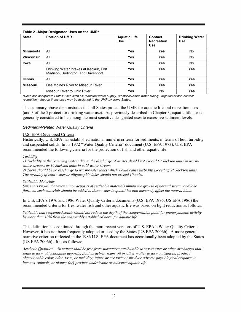
42
Table 2 –Major Designated Uses on the UMR* State Portion of UMR Aquatic Life
Use Contact Recreation Use
Drinking Water Use
Minnesota All Yes Yes No
Wisconsin All Yes Yes No
All Yes Yes No Iowa Drinking Water Intakes at Keokuk, Fort Madison, Burlington, and Davenport
Yes Yes Yes
Illinois All Yes Yes Yes Des Moines River to Missouri River Yes Yes Yes Missouri Missouri River to Ohio River Yes No Yes
*Does not incorporate States’ uses such as: industrial water supply, livestock/wildlife water supply, irrigation or non-contact recreation – though these uses may be assigned to the UMR by some States. The summary above demonstrates that all States protect the UMR for aquatic life and recreation uses (and 3 of the 5 protect for drinking water use). As previously described in Chapter 3, aquatic life use is generally considered to be among the most sensitive designated uses to excessive sediment levels. Sediment-Related Water Quality Criteria
U.S. EPA-Developed Criteria Historically, U.S. EPA has established national numeric criteria for sediments, in terms of both turbidity and suspended solids. In its 1972 “Water Quality Criteria” document (U.S. EPA 1973), U.S. EPA recommended the following criteria for the protection of fish and other aquatic life: Turbidity 1) Turbidity in the receiving waters due to the discharge of wastes should not exceed 50 Jackson units in warm-water streams or 10 Jackson units in cold-water stream. 2) There should be no discharge to warm-water lakes which would cause turbidity exceeding 25 Jackson units. The turbidity of cold-water or oligotrophic lakes should not exceed 10 units.
Settleable Materials Since it is known that even minor deposits of settleable materials inhibit the growth of normal stream and lake flora, no such materials should be added to these water in quantities that adversely affect the natural biota.
In U.S. EPA’s 1976 and 1986 Water Quality Criteria documents (U.S. EPA 1976, US EPA 1986) the recommended criteria for freshwater fish and other aquatic life was based on light reduction as follows: Settleable and suspended solids should not reduce the depth of the compensation point for photosynthetic activity by more than 10% from the seasonably established norm for aquatic life.
This definition has continued through the more recent versions of U.S. EPA’s Water Quality Criteria. However, it has not been frequently adopted or used by the States (US EPA 2006b). A more general narrative criterion reflected in the 1986 U.S. EPA document has occasionally been adopted by the States (US EPA 2006b). It is as follows: Aesthetic Qualities – All waters shall be free from substances attributable to wastewater or other discharges that: settle to form objectionable deposits; float as debris, scum, oil or other matter to form nuisances; produce objectionable color, odor, taste, or turbidity; injure or are toxic or produce adverse physiological response in humans, animals, or plants; [or] produce undesirable or nuisance aquatic life.
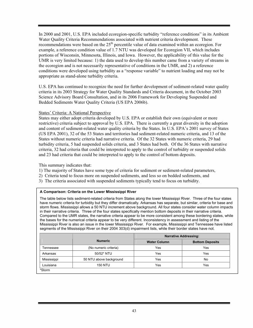
43
In 2000 and 2001, U.S. EPA included ecoregion-specific turbidity “reference conditions” in its Ambient Water Quality Criteria Recommendations associated with nutrient criteria development. These recommendations were based on the 25th percentile value of data examined within an ecoregion. For example, a reference condition value of 1.7 NTU was developed for Ecoregion VII, which includes portions of Wisconsin, Minnesota, Illinois, and Iowa. However, the applicability of this value for the UMR is very limited because: 1) the data used to develop this number came from a variety of streams in the ecoregion and is not necessarily representative of conditions in the UMR, and 2) a reference conditions were developed using turbidity as a “response variable” to nutrient loading and may not be appropriate as stand-alone turbidity criteria. U.S. EPA has continued to recognize the need for further development of sediment-related water quality criteria in its 2003 Strategy for Water Quality Standards and Criteria document, in the October 2003 Science Advisory Board Consultation, and in its 2006 Framework for Developing Suspended and Bedded Sediments Water Quality Criteria (US EPA 2006b). States’ Criteria: A National Perspective States may either adopt criteria developed by U.S. EPA or establish their own (equivalent or more restrictive) criteria subject to approval by U.S. EPA. There is currently a great diversity in the adoption and content of sediment-related water quality criteria by the States. In U.S. EPA’s 2001 survey of States (US EPA 2001), 32 of the 53 States and territories had sediment-related numeric criteria, and 13 of the States without numeric criteria had narrative criteria. Of the 32 States with numeric criteria, 29 had turbidity criteria, 5 had suspended solids criteria, and 3 States had both. Of the 36 States with narrative criteria, 32 had criteria that could be interpreted to apply to the control of turbidity or suspended solids and 23 had criteria that could be interpreted to apply to the control of bottom deposits. This summary indicates that: 1) The majority of States have some type of criteria for sediment or sediment-related parameters, 2) Criteria tend to focus more on suspended sediments, and less so on bedded sediments, and 3) The criteria associated with suspended sediments typically tend to focus on turbidity.
A Comparison: Criteria on the Lower Mississippi River
The table below lists sediment-related criteria from States along the lower Mississippi River. Three of the four states have numeric criteria for turbidity but they differ dramatically. Arkansas has separate, but similar, criteria for base and storm flows. Mississippi allows a 50 NTU increment above background. All four states consider water column impacts in their narrative criteria. Three of the four states specifically mention bottom deposits in their narrative criteria. Compared to the UMR states, the narrative criteria appear to be more consistent among these bordering states, while the bases for the numerical criteria appear to be very different. Inconsistency in assessment and listing of the Mississippi River is also an issue in the lower Mississippi River. For example, Mississippi and Tennessee have listed segments of the Mississippi River on their 2004 303(d) impairment lists, while their border states have not.
Narrative Addressing: Numeric Water Column Bottom Deposits
Tennessee (No numeric criteria) Yes Yes
Arkansas 50/52* NTU Yes Yes
Mississippi 50 NTU above background Yes No
Louisiana 150 NTU Yes Yes *Storm
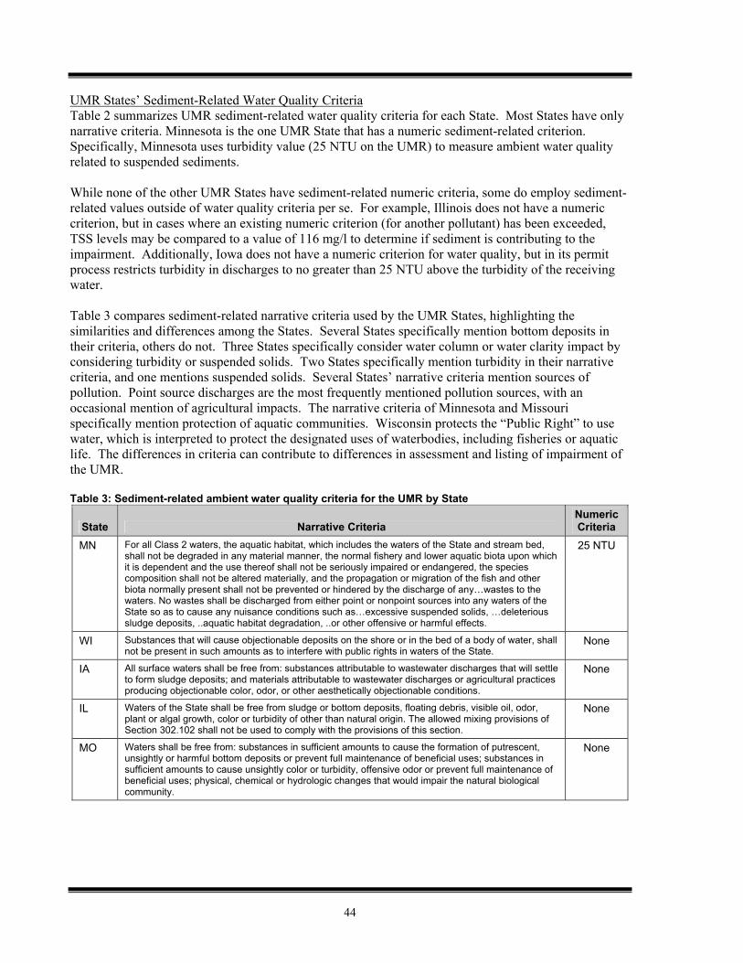
44
UMR States’ Sediment-Related Water Quality Criteria Table 2 summarizes UMR sediment-related water quality criteria for each State. Most States have only narrative criteria. Minnesota is the one UMR State that has a numeric sediment-related criterion. Specifically, Minnesota uses turbidity value (25 NTU on the UMR) to measure ambient water quality related to suspended sediments. While none of the other UMR States have sediment-related numeric criteria, some do employ sediment-related values outside of water quality criteria per se. For example, Illinois does not have a numeric criterion, but in cases where an existing numeric criterion (for another pollutant) has been exceeded, TSS levels may be compared to a value of 116 mg/l to determine if sediment is contributing to the impairment. Additionally, Iowa does not have a numeric criterion for water quality, but in its permit process restricts turbidity in discharges to no greater than 25 NTU above the turbidity of the receiving water. Table 3 compares sediment-related narrative criteria used by the UMR States, highlighting the similarities and differences among the States. Several States specifically mention bottom deposits in their criteria, others do not. Three States specifically consider water column or water clarity impact by considering turbidity or suspended solids. Two States specifically mention turbidity in their narrative criteria, and one mentions suspended solids. Several States’ narrative criteria mention sources of pollution. Point source discharges are the most frequently mentioned pollution sources, with an occasional mention of agricultural impacts. The narrative criteria of Minnesota and Missouri specifically mention protection of aquatic communities. Wisconsin protects the “Public Right” to use water, which is interpreted to protect the designated uses of waterbodies, including fisheries or aquatic life. The differences in criteria can contribute to differences in assessment and listing of impairment of the UMR. Table 3: Sediment-related ambient water quality criteria for the UMR by State
State Narrative Criteria Numeric Criteria
MN For all Class 2 waters, the aquatic habitat, which includes the waters of the State and stream bed, shall not be degraded in any material manner, the normal fishery and lower aquatic biota upon which it is dependent and the use thereof shall not be seriously impaired or endangered, the species composition shall not be altered materially, and the propagation or migration of the fish and other biota normally present shall not be prevented or hindered by the discharge of any…wastes to the waters. No wastes shall be discharged from either point or nonpoint sources into any waters of the State so as to cause any nuisance conditions such as…excessive suspended solids, …deleterious sludge deposits, ..aquatic habitat degradation, ..or other offensive or harmful effects.
25 NTU
WI Substances that will cause objectionable deposits on the shore or in the bed of a body of water, shall not be present in such amounts as to interfere with public rights in waters of the State.
None
IA All surface waters shall be free from: substances attributable to wastewater discharges that will settle to form sludge deposits; and materials attributable to wastewater discharges or agricultural practices producing objectionable color, odor, or other aesthetically objectionable conditions.
None
IL Waters of the State shall be free from sludge or bottom deposits, floating debris, visible oil, odor, plant or algal growth, color or turbidity of other than natural origin. The allowed mixing provisions of Section 302.102 shall not be used to comply with the provisions of this section.
None
MO Waters shall be free from: substances in sufficient amounts to cause the formation of putrescent, unsightly or harmful bottom deposits or prevent full maintenance of beneficial uses; substances in sufficient amounts to cause unsightly color or turbidity, offensive odor or prevent full maintenance of beneficial uses; physical, chemical or hydrologic changes that would impair the natural biological community.
None
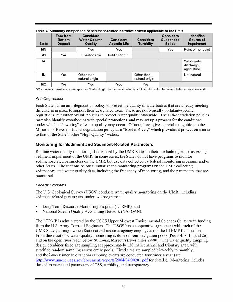
45
Table 4: Summary comparison of sediment-related narrative criteria applicable to the UMR
State
Free from Bottom Deposit
Considers Water Column
Quality Considers
Aquatic Life Considers Turbidity
Considers Suspended
Solids
Identifies Source of
Impairment MN Yes Yes Yes Point or nonpoint
WI Yes Questionable Public Right*
IA Wastewater discharge, agriculture
IL Yes Other than natural origin
Other than natural origin
Not natural
MO Yes Yes Yes Yes *Wisconsin’s narrative criteria specifies “Public Right” to use water which could be interpreted to include fisheries or aquatic life. Anti-Degradation
Each State has an anti-degradation policy to protect the quality of waterbodies that are already meeting the criteria in place to support their designated uses. These are not typically pollutant-specific regulations, but rather overall policies to protect water quality Statewide. The anti-degradation policies may also identify waterbodies with special protections, and may set up a process for the conditions under which a “lowering” of water quality may occur. Of note, Iowa gives special recognition to the Mississippi River in its anti-degradation policy as a “Border River,” which provides it protection similar to that of the State’s other “High Quality” waters. Monitoring for Sediment and Sediment-Related Parameters Routine water quality monitoring data is used by the UMR States in their methodologies for assessing sediment impairment of the UMR. In some cases, the States do not have programs to monitor sediment-related parameters on the UMR, but use data collected by federal monitoring programs and/or other States. The sections below summarize the monitoring programs on the UMR collecting sediment-related water quality data, including the frequency of monitoring, and the parameters that are monitored.
Federal Programs
The U.S. Geological Survey (USGS) conducts water quality monitoring on the UMR, including sediment related parameters, under two programs:
Long Term Resource Monitoring Program (LTRMP), and National Stream Quality Accounting Network (NASQAN).
The LTRMP is administered by the USGS Upper Midwest Environmental Sciences Center with funding from the U.S. Army Corps of Engineers. The USGS has a cooperative agreement with each of the UMR States, through which State natural resource agency employees run the LTRMP field stations. From these stations, water quality monitoring is done on four navigation pools (Pools 4, 8, 13, and 26) and on the open river reach below St. Louis, Missouri (river miles 29-80). The water quality sampling design combines fixed site sampling at approximately 120 main channel and tributary sites, with stratified random sampling across entire pools. Fixed sites are sampled bi-weekly to monthly, and the2-week intensive random sampling events are conducted four times a year (see http://www.umesc.usgs.gov/documents/reports/2004/04t00201.pdf for details). Monitoring includes the sediment-related parameters of TSS, turbidity, and transparency.
46
The National Stream Quality Accounting Network (NASQAN) includes measurements of TSS at three sites on the UMR – Clinton (IA), Thebes (IL) and Grafton (IL). Samples are collected 6 to 15 times per year (see http://water.usgs.gov/nasqan/progdocs/factsheets/missfact/missfs.html for details) In the period of 2004-2006, the U.S. EPA Great Rivers Environmental Monitoring and Assessment Program (EMAP-GRE) collected water quality data, including sediment-related parameters, in conjunction with the States’ field stations. EMAP is a statistically-based sampling program with sampling sites for each year being randomly selected. Approximately 170 total sites were sampled on the UMR during the three year period. EMAP-GRE data is currently being compiled and analyzed. It should soon provide both useful information on the status of the river and help States in implementing statistically sound monitoring programs. The US Army Corps of Engineers has also initiated a program of monitoring water transparency at UMR locks and dams. This information has recently become available on the RiverGages.com website at http://www2.mvr.usace.army.mil/water_transparency/water_transparency.cfm (Rock Island District) and http://www.mvp-wc.usace.army.mil/cgi-bin/wq/wq_init?site=mississippi (St. Paul District)
State Programs
Minnesota The Minnesota Pollution Control Agency surface water monitoring program is organized based on ten major drainage basins, one of which, the “Lower Mississippi,” includes the interstate boundary portion of the UMR. In this program there are three long term site-specific trend routine monitoring sites (milestone sites) on the UMR located at river mile 698 (below US-14 bridge at La Crosse), river mile 714 (Lock and Dam 6 at Trempealeau, WI), and river mile 738 (Lock and Dam 5, three miles southeast of Minneiska). These sites are sampled monthly (except for some winter months) two out of five years. Turbidity, TSS, and transparency are measured at these monitoring sites (UMRBA 2004).
Wisconsin The Wisconsin DNR conducts routine water quality monitoring at three lock and dam sites on the UMR. Turbidity and TSS are monitored at Lock and Dam 9. Transparency and turbidity are typically monitored quarterly at Locks and Dams 3 and 4. Gross sedimentation have routinely been measured using sediment traps, primarily at Lock and Dams 3 and 4 as well as selected backwater areas. Wisconsin has also deployed continuous water samplers to measure turbidity and TSS in backwater areas of Pools 5 and 8. Light penetration monitoring has been conducted at Locks and Dams 8 and 9 since 1988 (Sullivan 2005b).
Iowa Iowa DNR updated its routine ambient water quality monitoring program utilizing stakeholder input during 1999 and 2000. The monitoring program task force decided, based on stakeholder input, not to include sites on the UMR in the updated routine ambient water quality monitoring program (Olson 2005). As a result, the Iowa DNR currently has no routine ambient water quality monitoring sites located on the Mississippi River (see http://wqm.igsb.uiowa.edu for details).
Illinois TSS is monitored on the UMR in Illinois at 11 Illinois Ambient Water Quality Monitoring Network (AWQMN) sites located on the UMR as part of the Illinois EPA Great River Boundary monitoring program. These monitoring stations are located at approximately 50-mile intervals on the Mississippi River along the Illinois border. The eight stations upstream of St. Louis are located at the locks and dams, and the three stations downstream of St. Louis are located at boat ramps on the river. Water
47
samples are collected from these sites quarterly (UMRBA 2004). These samples are analyzed for a set of core chemical parameters that includes TSS (UMRBA 2004, U.S. EPA 2002). Missouri The Missouri DNR monitors at one fixed station site on the UMR near Grafton, Illinois. This site is part of the USGS NASQAN network and is sampled 6 to 12 times a year. Sample analyses include the sediment-related parameter, TSS (UMRBA 2004). Data Sharing and Data Summaries
Each of the State and federal programs mentioned in the preceding sections collects and stores their own data. Additionally, the States rely upon data collected by neighboring States and federal agencies in developing their CWA assessments. Also of note is the summary report of UMR water quality data assembled by the UMRCC and US EPA (UMRRC 2002), as well as subsequent data updates available online at http://www.epa.gov/region5/water/umr_wq_assess.htm.
Summary of Monitoring Programs
Comparison of the routine sampling programs of the UMR yields the following observations:
Iowa is the only State that does not perform water quality monitoring on the UMR (other than the monitoring conducted on Pool 13 by the LTRMP Bellevue Field Station).
Sediment-related parameters are monitored intensively in Pools 4, 8, 13, and 26, through the LTRMP, administered by USGS.
There are approximately 16 routine water quality monitoring sites on the UMR where sediment-related parameters are monitored by other USGS and State programs.
TSS is the most frequently monitored sediment-related parameter in the UMR. USGS (LTRMP and NASQAN), Illinois, Minnesota, Missouri, and Wisconsin all monitor TSS.
Turbidity is monitored less frequently in the UMR than TSS; USGS (LTRMP), Minnesota, and Wisconsin monitor turbidity. Transparency is also monitored at a limited number of locations.
States’ Methods for Assessing and Identifying Sediment-Related Impairment on the UMR Under Section 305(b) of the Clean Water Act, States are required to submit biennial water quality assessment reports to the U.S. EPA. These reports are intended to provide an overall perspective on water quality conditions in each State. More specifically, Section 305(b) directs the States to describe the quality of their surface waters; analyze the extent to which various designated uses such as aquatic life and recreation, are protected; estimate the costs and benefits associated with protecting those uses; and describe the impact of point and non-point source pollutants (UMRBA 2004). In practice, States assess the quality of their waters for all designated uses for which data are available. In addition to presenting a snapshot of current water quality conditions and providing insight into the progress being made in protecting their surface waters, States use their Section 305(b) assessment of use support as a substantial basis in the determination of impairment for their Section 303(d) lists of impaired waters. Section 303(d) of the Clean Water Act requires States to develop lists of impaired waters, assign a priority ranking to those waterbodies, and develop TMDLs for them. Impaired waters are those waterbodies that do not meet the water quality standards set for them by States. EPA has provided guidance to the States that 305(b) assessments and 303(d) impairment listings should be combined into a single integrated report (US EPA 2006c). States have begun moving towards this integrated reporting approach during their 2006 reporting cycle.
48
States’ Assessment Methodologies for Sediment-Related Impairment
Minnesota The Minnesota Pollution Control Agency assesses sediment impairment of the aquatic life use based on its turbidity water quality criterion (see Table 2). River segments with less than 10% of turbidity measurements greater than the turbidity criterion are classified as supporting the aquatic life use. If between 10% and 25% of turbidity measurements are greater than the turbidity criterion, the waterbody is classified as partially supporting the aquatic life use. If 25% or more of turbidity measurements exceed the turbidity standard, the waterbody is classified as not supporting the aquatic life use (MPCA 2004). To assess sediment impairment, turbidity measurements from the most recent 10 years are used, and there must be at least 10 measurements in the assessment data set (MPCA 2004). The Minnesota Pollution Control Agency utilizes turbidity data from its own monitoring programs as well as data from the USGS LTRMP and Wisconsin Department of Natural Resources in assessing sediment impairment of the UMR (UMRBA 2004, MPCA 2004). No assessment of UMR sedimentation is currently made by the Minnesota Pollution Control Agency (U.S. EPA 2003a).
Wisconsin The Wisconsin Department of Natural Resources (DNR) assesses lakes and streams both for the exceedance of numeric and narrative water quality criteria, and to determine whether designated uses are being met. To date, the UMR has been assessed using existing and applicable water quality criteria. However, Wisconsin does not have numeric water quality criteria for sediment-related parameters (i.e. turbidity or TSS). As a result, Wisconsin DNR has not formally assessed the UMR for sediment impairment specifically, although it is working on developing an assessment methodology for large rivers and is considering a proposal for a UMR impairment listing in 2008 based on turbidity levels. Iowa The Iowa DNR assesses for impairment by comparing water quality to the State numeric water quality criteria. UMR water quality data collected by the USGS, Wisconsin, Illinois, and as part of special studies are used to assess UMR impairment. Since the State does not currently have numeric water quality criteria for sediment-related parameters, the Iowa DNR essentially does not currently assess the UMR for sediment-related impairment. The Iowa DNR does have a methodology for assessing sediment as a potential cause of biological impairment in wadeable streams (U.S. EPA 2003a).
Illinois Illinois EPA only assesses sediment as a potential cause of impairment when a numeric water quality criterion (for a another parameter) has been exceeded for a river segment. In these cases, IL EPA will examine sediment as a contributor to impairment using TSS measurements. Then, if TSS exceeds 116 mg/L in at least one sample, sediment is listed as a potential cause of impairment for the river segment. The TSS guidance of 116 mg/L is the 85th percentile of measurements at all ambient water quality monitoring network sites (U.S. EPA 2003a). Illinois EPA uses TSS measurements from their own monitoring program, as well as data from the NASQAN and LTRMP to assess the UMR. Missouri The Missouri DNR assesses impairment based on violations of numeric water quality criteria and numeric guidelines associated with the narrative criteria. UMR water quality data collected by Missouri and Illinois agencies, as well as the USGS, are used to assess UMR impairment. Missouri does not have numeric water quality standards for sediment-related parameters (i.e. turbidity and TSS), so sediment-related water quality is not assessed. The Missouri DNR does use a percent fines numeric guideline for assessing bottom deposits under the narrative criteria (MO DNR 2004). However, the data needed to use this guideline is not collected on the UMR. As a result, the Missouri DNR does not assess sediment impairment on the Mississippi River (U.S. EPA 2003a).
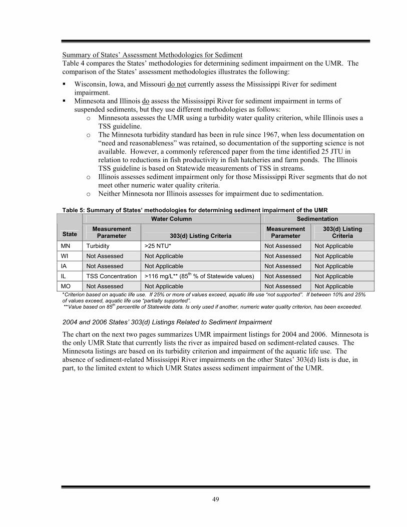
49
Summary of States’ Assessment Methodologies for Sediment Table 4 compares the States’ methodologies for determining sediment impairment on the UMR. The comparison of the States’ assessment methodologies illustrates the following:
Wisconsin, Iowa, and Missouri do not currently assess the Mississippi River for sediment impairment.
Minnesota and Illinois do assess the Mississippi River for sediment impairment in terms of suspended sediments, but they use different methodologies as follows:
o Minnesota assesses the UMR using a turbidity water quality criterion, while Illinois uses a TSS guideline.
o The Minnesota turbidity standard has been in rule since 1967, when less documentation on “need and reasonableness” was retained, so documentation of the supporting science is not available. However, a commonly referenced paper from the time identified 25 JTU in relation to reductions in fish productivity in fish hatcheries and farm ponds. The Illinois TSS guideline is based on Statewide measurements of TSS in streams.
o Illinois assesses sediment impairment only for those Mississippi River segments that do not meet other numeric water quality criteria.
o Neither Minnesota nor Illinois assesses for impairment due to sedimentation.
Table 5: Summary of States’ methodologies for determining sediment impairment of the UMR Water Column Sedimentation
State Measurement
Parameter 303(d) Listing Criteria Measurement
Parameter 303(d) Listing
Criteria MN Turbidity >25 NTU* Not Assessed Not Applicable
WI Not Assessed Not Applicable Not Assessed Not Applicable
IA Not Assessed Not Applicable Not Assessed Not Applicable
IL TSS Concentration >116 mg/L** (85th % of Statewide values) Not Assessed Not Applicable
MO Not Assessed Not Applicable Not Assessed Not Applicable *Criterion based on aquatic life use. If 25% or more of values exceed, aquatic life use “not supported”. If between 10% and 25% of values exceed, aquatic life use “partially supported”. **Value based on 85th percentile of Statewide data. Is only used if another, numeric water quality criterion, has been exceeded. 2004 and 2006 States’ 303(d) Listings Related to Sediment Impairment
The chart on the next two pages summarizes UMR impairment listings for 2004 and 2006. Minnesota is the only UMR State that currently lists the river as impaired based on sediment-related causes. The Minnesota listings are based on its turbidity criterion and impairment of the aquatic life use. The absence of sediment-related Mississippi River impairments on the other States’ 303(d) lists is due, in part, to the limited extent to which UMR States assess sediment impairment of the UMR.
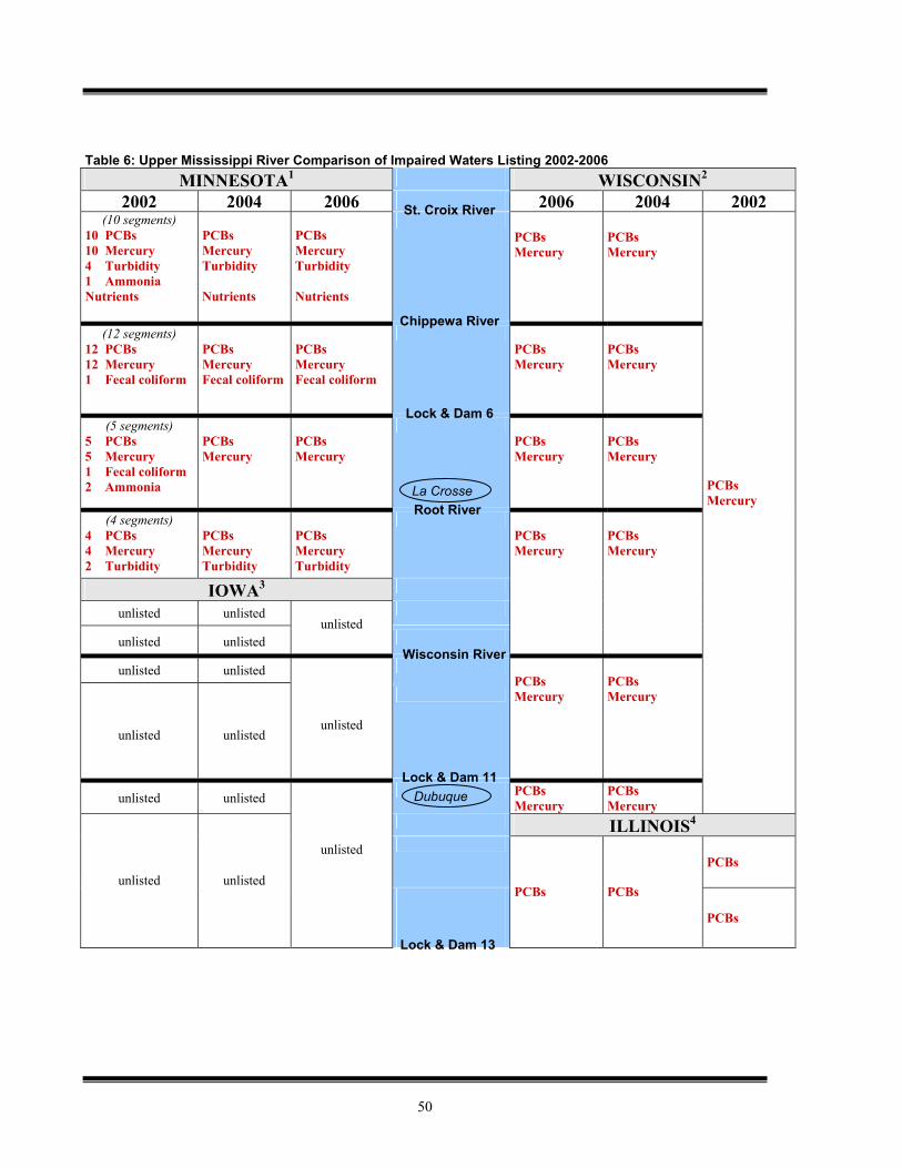
50
Table 6: Upper Mississippi River Comparison of Impaired Waters Listing 2002-2006
MINNESOTA1 WISCONSIN2 2002 2004 2006 2006 2004 2002
(10 segments) 10 PCBs 10 Mercury 4 Turbidity 1 Ammonia Nutrients
PCBs Mercury Turbidity Nutrients
PCBs Mercury Turbidity Nutrients
PCBs Mercury
PCBs Mercury
(12 segments) 12 PCBs 12 Mercury 1 Fecal coliform
PCBs Mercury Fecal coliform
PCBs Mercury Fecal coliform
PCBs Mercury
PCBs Mercury
(5 segments) 5 PCBs 5 Mercury 1 Fecal coliform 2 Ammonia
PCBs Mercury
PCBs Mercury
PCBs Mercury
PCBs Mercury
PCBs Mercury
(4 segments) 4 PCBs 4 Mercury 2 Turbidity
PCBs Mercury Turbidity
PCBs Mercury Turbidity
PCBs Mercury
PCBs Mercury
IOWA3
unlisted unlisted
unlisted unlisted
unlisted
unlisted unlisted
unlisted
unlisted
unlisted
PCBs Mercury
PCBs Mercury
unlisted unlisted PCBs Mercury
PCBs Mercury
ILLINOIS4
PCBs unlisted unlisted
unlisted
PCBs PCBs
PCBs
St. Croix River
Chippewa River
Wisconsin River
Root River La Crosse
Lock & Dam 6
Lock & Dam 11 Dubuque
Lock & Dam 13
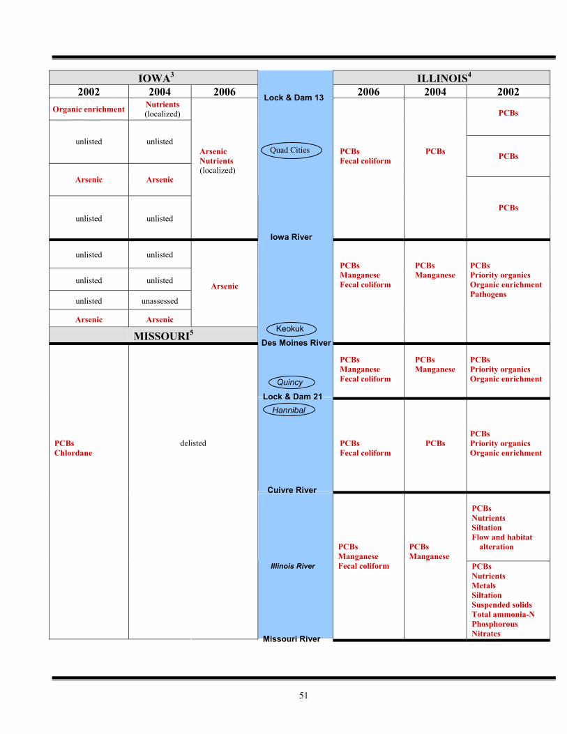
51
IOWA3 ILLINOIS4 2002 2004 2006 2006 2004 2002
Organic enrichment Nutrients (localized)
PCBs
unlisted unlisted
PCBs
Arsenic Arsenic
unlisted unlisted
Arsenic Nutrients (localized)
PCBs Fecal coliform
PCBs
PCBs
unlisted unlisted
unlisted unlisted
unlisted unassessed
Arsenic Arsenic
Arsenic
MISSOURI5
PCBs Manganese Fecal coliform
PCBs Manganese
PCBs Priority organics Organic enrichment Pathogens
PCBs Manganese Fecal coliform
PCBs Manganese
PCBs Priority organics Organic enrichment
PCBs Chlordane
delisted
PCBs Fecal coliform
PCBs
PCBs Priority organics Organic enrichment
PCBs Nutrients Siltation Flow and habitat
alteration
PCBs Manganese Fecal coliform
PCBs Manganese
PCBs Nutrients Metals Siltation Suspended solids Total ammonia-N Phosphorous Nitrates
Keokuk
Des Moines River
Lock & Dam 21 Quincy
Hannibal
Missouri River
Illinois River
Quad Cities
Lock & Dam 13
Iowa River
Cuivre River
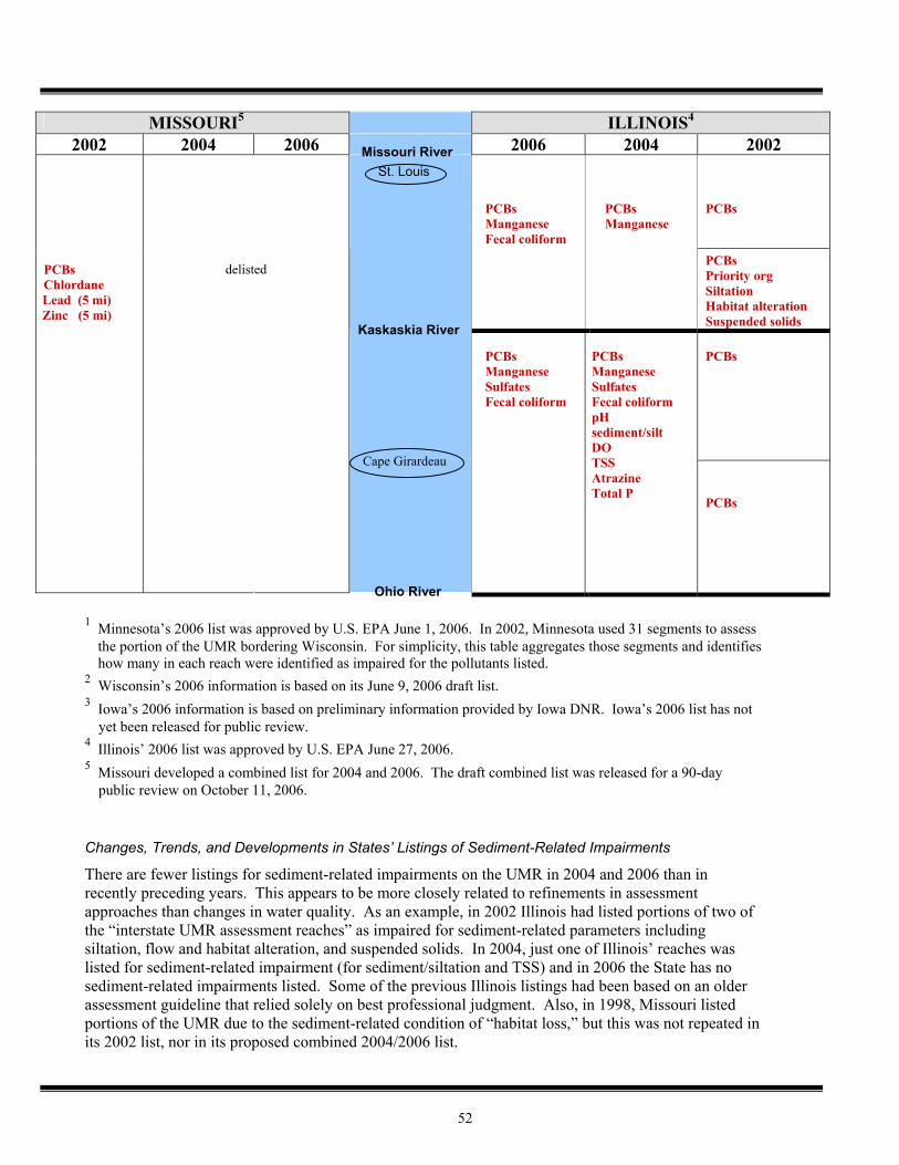
52
MISSOURI5 ILLINOIS4 2002 2004 2006 2006 2004 2002
PCBs Manganese
PCBs
PCBs Chlordane Lead (5 mi) Zinc (5 mi)
delisted
PCBs Manganese Fecal coliform
PCBs Priority org Siltation Habitat alteration Suspended solids PCBs
PCBs Manganese Sulfates Fecal coliform
PCBs Manganese Sulfates Fecal coliform pH sediment/silt DO TSS Atrazine Total P
PCBs
1 Minnesota’s 2006 list was approved by U.S. EPA June 1, 2006. In 2002, Minnesota used 31 segments to assess
the portion of the UMR bordering Wisconsin. For simplicity, this table aggregates those segments and identifies how many in each reach were identified as impaired for the pollutants listed.
2 Wisconsin’s 2006 information is based on its June 9, 2006 draft list. 3 Iowa’s 2006 information is based on preliminary information provided by Iowa DNR. Iowa’s 2006 list has not
yet been released for public review. 4 Illinois’ 2006 list was approved by U.S. EPA June 27, 2006. 5 Missouri developed a combined list for 2004 and 2006. The draft combined list was released for a 90-day
public review on October 11, 2006. Changes, Trends, and Developments in States’ Listings of Sediment-Related Impairments
There are fewer listings for sediment-related impairments on the UMR in 2004 and 2006 than in recently preceding years. This appears to be more closely related to refinements in assessment approaches than changes in water quality. As an example, in 2002 Illinois had listed portions of two of the “interstate UMR assessment reaches” as impaired for sediment-related parameters including siltation, flow and habitat alteration, and suspended solids. In 2004, just one of Illinois’ reaches was listed for sediment-related impairment (for sediment/siltation and TSS) and in 2006 the State has no sediment-related impairments listed. Some of the previous Illinois listings had been based on an older assessment guideline that relied solely on best professional judgment. Also, in 1998, Missouri listed portions of the UMR due to the sediment-related condition of “habitat loss,” but this was not repeated in its 2002 list, nor in its proposed combined 2004/2006 list.
Missouri River St. Louis
Ohio River
Cape Girardeau
Kaskaskia River
53
Additionally, Iowa DNR’s 1998 303(d) listing faced a legal challenge because it did not include a sediment-related listing of the UMR. Following a consent decree and research conducted by Iowa DNR, both US EPA Region 7 and Iowa DNR determined that sediment-related impairment of the aquatic life use on the UMR in Iowa did not exist. This determination was based on the following: 1) evidence of impact to aquatic life was not conclusive, 2) Iowa’s water quality standards did not allow for a quantitative determination of sediment impairment, and 3) observed problems are more appropriately attributed to the hydrological alteration of the UMR, rather than to sediment specifically. As a result, sediment-related impairments for the UMR were not included in Iowa’s 2002 list, nor on its 2004 or proposed 2006 list. TMDLs and Other Corrective Actions If monitoring and assessment indicate that a waterbody (or waterbody segment) is impaired by one or more pollutants and appears on the 303(d) list, then the State must develop a strategy that will lead to attainment of water quality standards. Such strategies consist of a Total Maximum Daily Load (TMDL) or another comprehensive strategy that includes a functional equivalent of a TMDL (US EPA 2003d). Existing Sediment-Related TMDLs on the UMR
Currently, only Minnesota lists segments of the UMR with impairments related to sediment. Minnesota is working on a TMDL for Lake Pepin (Pool 4 of the UMR), which addresses turbidity impairment, as well as nutrient impairment. The Lake Pepin TMDL is targeted for completion in 2009, after which implementation begins. The total costs for the 5-year process is projected to be over $2.6 million (Hall 2006). Alternate Characterization of Impairment and Non-TMDL Remedies
It is possible for a State to identify an impairment of a waterbody, but classify that impairment such that a TMDL is not the required remedy for the impairment. According to US EPA’s 2006 Guidance for Assessment, Listing, and Reporting (USEPA 2006c), this situation arises when “the State demonstrates that the failure to meet an applicable water quality standard is not caused by a pollutant, but instead is caused by other types of pollution”. Further, the Clean Water Act, at Section 502(19) defines pollution as “the man-made or man-induced alteration of the chemical, physical, biological, and radiological integrity of the water.” Illinois and Iowa have employed this characterization to a limited extent for lakes, but no UMR States have employed this characterization for sediment-related impairments on the UMR. Habitat Restoration and Protection
While not part of the States’ Clean Water Act programs nor undertaken in response to impairment listings, techniques such as backwater dredging, island construction, and bank stabilization are often used to address sediment-related ecosystem impacts on the UMR, especially backwater sedimentation. In particular, the U.S. Army Corps of Engineers’ Environmental Management Program (EMP) and Navigation and Ecosystem Sustainability Program (NESP) are designed to rehabilitate and protect habitat areas, many of which are threatened by excess sediment. Exploring connections between these ecosystem restoration efforts and the Clean Water Act may be part of a comprehensive approach to resolving sediment issues on the UMR. Summary, Unknowns, and Implications Regarding States’ Current Approaches to Sediment on the UMR Summary
Each State has established aquatic life as a designated use for the UMR.
54
There is no current national water quality guidance from EPA for sediment or sediment-related criteria that is applicable to the UMR or other large rivers. Nationally, States take a variety of approaches to sediment-related water quality criteria.
All of the UMR States have narrative criteria applicable to sediment or sediment-related parameters. Only Minnesota has a numeric criterion (for turbidity).
Although there are a number of State and Federal water quality monitoring programs on the UMR, the programs do not necessarily take a common approach in terms of the parameter monitored, the frequency, or location of the monitoring. The States’ level of effort UMR monitoring varies.
Three of the five UMR States do not assess the UMR for sediment-related impairment. Minnesota and Illinois do address suspended sediments in their assessments of the UMR, though Illinois’ approach is indirect. Neither Minnesota nor Illinois assesses for sedimentation.
There are currently fewer sediment-related UMR impairments than in the recent past. Currently only Minnesota lists any portion of the UMR as impaired for sediment-related reasons.
Only Minnesota is working on a TMDL for the UMR which addresses sediment.
Differences in the States’ approaches to criteria, monitoring, and assessment all contribute to differences in how the States’ characterize the condition of the UMR in terms of impairment status. Currently, the sediment-related disparities for specific UMR river reaches include Lake Pepin (Pool 4) and the reach from the Root River to the Iowa border. Minnesota lists these reaches as impaired due to turbidity, while Wisconsin has not identified either of these segments as impaired for sediment-related parameters.
Given that most UMR States do not have numeric criteria for sediment-related parameters and do not assess the UMR for sediment-related impairments, there is actually a fairly high degree of similarity among them in their current approach.
Unknowns
The States’ definitions of aquatic life use do not specifically name vegetation as an aquatic life type to be protected. Whether the use definitions could be interpreted to allow for the direct protection of vegetation has not yet been determined. This question may be particularly relevant if the UMRCC SAV-protection criteria proposal is incorporated in the approach for the UMR.
Implications
Because aquatic life use is considered a “sensitive” use, and because all the States include aquatic life in their designated uses for the UMR, a logical point of departure for developing a common approach to sediment on the UMR is to examine water quality criteria that are protective of the aquatic life use.
There is a need for more coordinated monitoring of sediment-related parameters on the UMR and increased sharing of monitoring data.
The cost and time frame associated with Minnesota’s Lake Pepin TMDL may be indicative of the scope of remedies associated with identifying a sediment impairment on the UMR.
Connections between water quality impairment and ecosystem restoration activities undertaken by the Corps of Engineers should be explored, as they may offer “non-TMDL” remedies for identified sediment impairments.
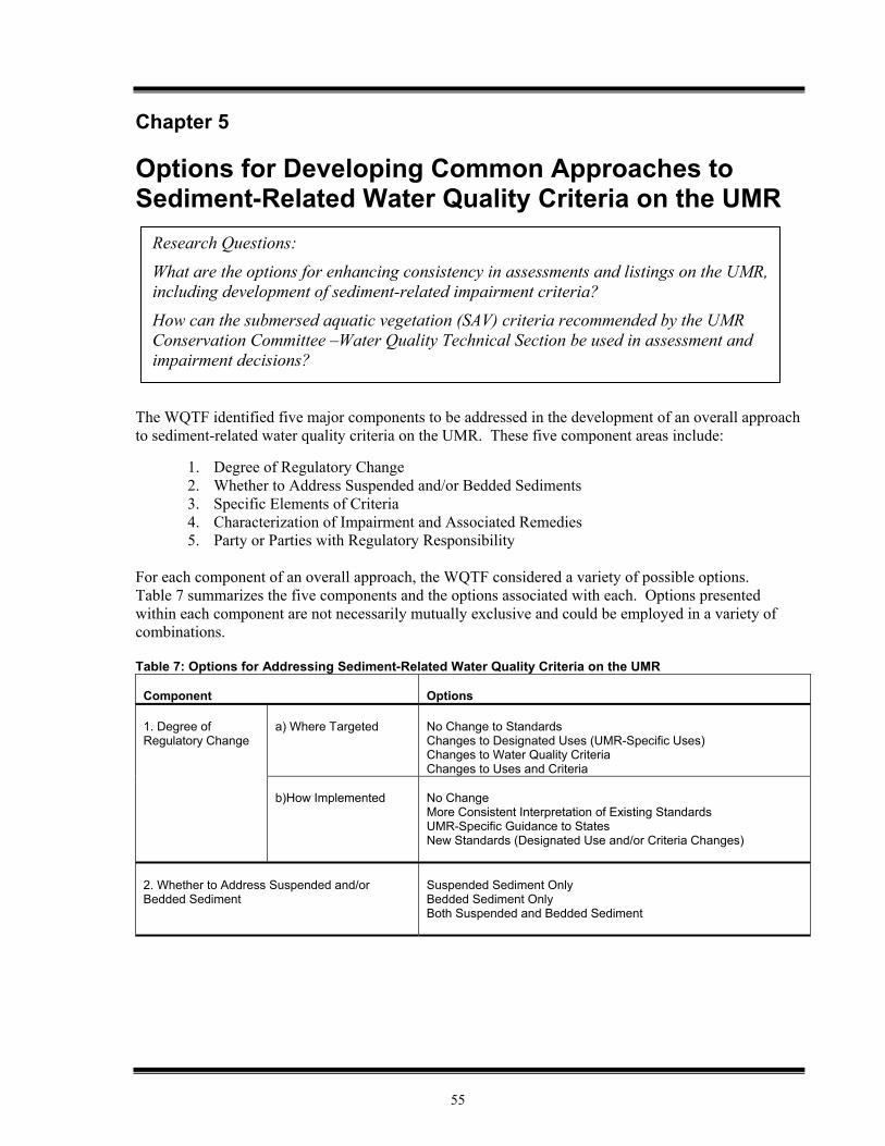
55
Chapter 5 Options for Developing Common Approaches to Sediment-Related Water Quality Criteria on the UMR The WQTF identified five major components to be addressed in the development of an overall approach to sediment-related water quality criteria on the UMR. These five component areas include:
1. Degree of Regulatory Change 2. Whether to Address Suspended and/or Bedded Sediments 3. Specific Elements of Criteria 4. Characterization of Impairment and Associated Remedies 5. Party or Parties with Regulatory Responsibility
For each component of an overall approach, the WQTF considered a variety of possible options. Table 7 summarizes the five components and the options associated with each. Options presented within each component are not necessarily mutually exclusive and could be employed in a variety of combinations. Table 7: Options for Addressing Sediment-Related Water Quality Criteria on the UMR
Component
Options
a) Where Targeted
No Change to Standards Changes to Designated Uses (UMR-Specific Uses) Changes to Water Quality Criteria Changes to Uses and Criteria
1. Degree of Regulatory Change
b)How Implemented
No Change More Consistent Interpretation of Existing Standards UMR-Specific Guidance to States New Standards (Designated Use and/or Criteria Changes)
2. Whether to Address Suspended and/or Bedded Sediment
Suspended Sediment Only Bedded Sediment Only Both Suspended and Bedded Sediment
Research Questions:
What are the options for enhancing consistency in assessments and listings on the UMR, including development of sediment-related impairment criteria?
How can the submersed aquatic vegetation (SAV) criteria recommended by the UMR Conservation Committee –Water Quality Technical Section be used in assessment and impairment decisions?
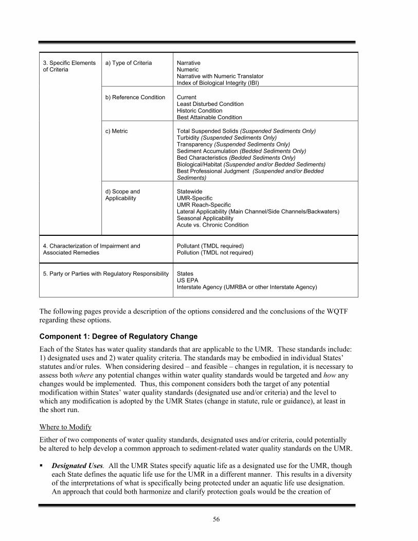
56
a) Type of Criteria
Narrative Numeric Narrative with Numeric Translator Index of Biological Integrity (IBI)
b) Reference Condition
Current Least Disturbed Condition Historic Condition Best Attainable Condition
c) Metric
Total Suspended Solids (Suspended Sediments Only) Turbidity (Suspended Sediments Only) Transparency (Suspended Sediments Only) Sediment Accumulation (Bedded Sediments Only) Bed Characteristics (Bedded Sediments Only) Biological/Habitat (Suspended and/or Bedded Sediments) Best Professional Judgment (Suspended and/or Bedded Sediments)
3. Specific Elements of Criteria
d) Scope and Applicability
Statewide UMR-Specific UMR Reach-Specific Lateral Applicability (Main Channel/Side Channels/Backwaters) Seasonal Applicability Acute vs. Chronic Condition
4. Characterization of Impairment and Associated Remedies
Pollutant (TMDL required) Pollution (TMDL not required)
5. Party or Parties with Regulatory Responsibility
States US EPA Interstate Agency (UMRBA or other Interstate Agency)
The following pages provide a description of the options considered and the conclusions of the WQTF regarding these options. Component 1: Degree of Regulatory Change Each of the States has water quality standards that are applicable to the UMR. These standards include: 1) designated uses and 2) water quality criteria. The standards may be embodied in individual States’ statutes and/or rules. When considering desired – and feasible – changes in regulation, it is necessary to assess both where any potential changes within water quality standards would be targeted and how any changes would be implemented. Thus, this component considers both the target of any potential modification within States’ water quality standards (designated use and/or criteria) and the level to which any modification is adopted by the UMR States (change in statute, rule or guidance), at least in the short run. Where to Modify
Either of two components of water quality standards, designated uses and/or criteria, could potentially be altered to help develop a common approach to sediment-related water quality standards on the UMR. Designated Uses. All the UMR States specify aquatic life as a designated use for the UMR, though
each State defines the aquatic life use for the UMR in a different manner. This results in a diversity of the interpretations of what is specifically being protected under an aquatic life use designation. An approach that could both harmonize and clarify protection goals would be the creation of
57
specific aquatic life use designation(s) for the UMR. This might also allow the States to jointly answer such questions as whether vegetation alone is considered aquatic life to be protected. Potential drawbacks to pursuing UMR-specific designated uses might include reducing individual States’ flexibility, the technical complexity of the issue, and the potential for opening up all a States’ uses for review (and thereby slowing progress overall).
Water Quality Criteria. Harmonization in approach to sediment on the UMR could also be
accomplished by addressing water quality criteria. The UMR States all have differing narrative criteria which apply in determining whether sediment is affecting designated uses for the UMR. Only Minnesota has a numeric criterion. It may be possible to make progress in developing a common approach by agreeing to common numeric water quality criteria for the UMR or, at minimum, creating common interpretations of existing narrative criteria. Although there appear to be less procedural hurdles in modifying criteria (as opposed to designated uses), it is possible that adjusting criteria alone, without addressing designated uses, may still leave disparity in interpretation.
It may be possible to make changes in both of the above components of water quality standards. This approach, of course, would carry along with it both the advantages and disadvantages of each of the individual changes. How to Implement
In addition to considering where changes should be targeted another important consideration is how to carry out any identified modifications. A modest step that could be made is simply to encourage States to interpret their existing standards more consistently, leading to more congruent assessments and listings between States. This is already being done, in a sense, through the WQTF’s ongoing consultations, which could be enhanced to focus more effort on sediment-related issues. On the other end of the spectrum of change, the States could agree to modify their water quality standards in statute and/or rule, in accordance with the recommendations of the WQTF. Between these two approaches is the option of developing UMR-specific guidance, which could be adopted by the individual States, as appropriate. A guidance document could also be a “testing ground” that might lead to eventual adoption of common standards among the States. Conclusions of the WQTF
1. Sediment-related work should be focused on the development of common water quality criteria in the near term.
2. A guidance document should be developed for the States to use, as appropriate, in making any changes to water quality standards or their interpretation.
Rationale
Focusing sediment work on criteria development may involve fewer procedural obstacles and time than modifying designated uses. Moreover, the States all have some type of aquatic life use already designated for the river. Therefore, the States can use those aquatic life designated uses as a departure point for work on criteria. Development of UMR-specific designated uses shall also be considered, but as part of larger effort which involves the input and assistance of State water quality program administrators. Guidance is the preferred tool for implementation because it accommodates the States’ varying ability to incorporate changes into standards and the varying speed at which States’ processes may allow changes to be incorporated. Additionally, this approach also provides the opportunity to gain experience in the use of recommended criteria before committing to them in statute and/or rule.
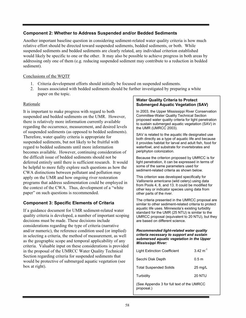
58
Component 2: Whether to Address Suspended and/or Bedded Sediments Another important baseline question in considering sediment-related water quality criteria is how much relative effort should be directed toward suspended sediments, bedded sediments, or both. While suspended sediments and bedded sediments are clearly related, any individual criterion established would likely be specific to one or the other. It may also be possible to achieve progress in both areas by addressing only one of them (e.g. reducing suspended sediment may contribute to a reduction in bedded sediment). Conclusions of the WQTF
1. Criteria development efforts should initially be focused on suspended sediments. 2. Issues associated with bedded sediments should be further investigated by preparing a white
paper on the topic. Rationale
It is important to make progress with regard to both suspended and bedded sediments on the UMR. However, there is relatively more information currently available regarding the occurrence, measurement, and desired levels of suspended sediments (as opposed to bedded sediments). Therefore, water quality criteria is appropriate for suspended sediments, but not likely to be fruitful with regard to bedded sediments until more information becomes available. However, continuing consideration of the difficult issue of bedded sediments should not be deferred entirely until there is sufficient research. It would be helpful to more fully explore such questions as how the CWA distinctions between pollutant and pollution may apply on the UMR and how ongoing river restoration programs that address sedimentation could be employed in the context of the CWA. Thus, development of a “white paper” on such questions is recommended. Component 3: Specific Elements of Criteria If a guidance document for UMR sediment-related water quality criteria is developed, a number of important scoping decisions must be made. These decisions include considerations regarding the type of criteria (narrative and/or numeric), the reference condition used (or implied) in selecting a criteria, the method of measurement, as well as the geographic scope and temporal applicability of any criteria. Valuable input on these considerations is provided in the proposal of the UMRCC Water Quality Technical Section regarding criteria for suspended sediments that would be protective of submerged aquatic vegetation (see box at right).
Water Quality Criteria to Protect Submerged Aquatic Vegetation (SAV) In 2003, the Upper Mississippi River Conservation Committee-Water Quality Technical Section proposed water quality criteria for light penetration to sustain submerged aquatic vegetation (SAV) in the UMR (UMRCC 2003).
SAV is related to the aquatic life designated use both directly as a type of aquatic life and because it provides habitat for larval and adult fish, food for waterfowl, and substrate for invertebrates and periphyton colonization.
Because the criterion proposed by UMRCC is for light penetration, it can be expressed in terms of some of the same parameters used for sediment-related criteria as shown below.
This criterion was developed specifically for Vallisneria americana (wild celery) using data from Pools 4, 8, and 13. It could be modified for other key or indicator species using data from other parts of the river.
The criteria presented in the UMRCC proposal are similar to other sediment-related criteria to protect aquatic life uses. Minnesota’s existing turbidity standard for the UMR (25 NTU) is similar to the UMRCC proposal (equivalent to 20 NTU), but they are based on different science. Recommended light-related water quality criteria necessary to support and sustain submersed aquatic vegetation in the Upper Mississippi River: Light Extinction Coefficient 3.42 m-1
Secchi Disk Depth 0.5 m Total Suspended Solids 25 mg/L Turbidity 20 NTU (See Appendix 3 for full text of the UMRCC proposal.)
59
Type of Criteria Within States’ water quality standards, water quality criteria may be expressed in narrative and/or numeric forms. Currently, all the UMR States have narrative criteria applicable to sediment, but only one (Minnesota) has a numeric criterion. In the development of any new sediment-related criteria, a decision must be made as to whether such criteria will be in narrative form, numeric form, or both. Advantages of narrative criteria include greater flexibility and potentially broader applicability, while numeric criteria may be viewed as more straightforward to understand, apply, and defend. It is also possible to use an approach where the criteria themselves are narrative, but a “numeric translator” is applied in the interpretation of the criteria. Criteria could also be established that assess habitat or biological conditions, such as an index of biological integrity (IBI) specific for sediment. Reference Condition
A reference condition establishes a goal for protection or restoration of water quality and facilitates the creation of criteria to meet that goal. Even if there is not an explicit and rigorous establishment of reference condition in creating criteria, there is always, at minimum, an implicit goal or desired condition. One of the primary challenges in developing criteria, or even designated uses, is defining the appropriate reference condition. Options for establishing reference condition can include: 1) current condition, 2) least disturbed condition, 3) a selected historic condition, or 4) best attainable condition. For the UMR, discussion regarding reference condition must take place in light of the substantial, and likely permanent, modifications that have been made on the UMR to support navigation. Metric(s) Multiple options for measuring suspended and/or bedded sediment exist. In the development of criteria, decisions would need to be made regarding which metric(s) will be employed on the UMR. Options for the measurement of suspended sediment include total suspended solids (TSS), turbidity, and transparency. Measurements of each of these parameters are currently taking place on the UMR, though agencies may monitor for different parameters. Currently, Minnesota uses turbidity and Illinois uses TSS (indirectly) in assessing impairment related to suspended sediment. However, Minnesota may be moving away from the use of turbidity, due to concerns regarding consistent measurement. Of note, the UMRCC SAV protection criterion proposal offers flexibility in the selection of a metric, as it provides equivalent references in terms of turbidity, TSS, and transparency. In regard to bedded sediments, measurements could be made of sediment accumulation or of bed characteristics. Sediment accumulation could be measured through approaches such as sedimentation rates or bed deposit depth. Characteristics of the bed related to sedimentation include relative bed stability (RBS) and embeddedness, though it is not currently clear how applicable these measurements are to a large modified river such as the UMR. Measurements of habitat or biological conditions could be indicative of suspended and/or bedded sediment concentrations. Additionally, best professional judgment has been employed to assess both suspended and bedded sediment conditions. Geographic and Temporal Applicability
In developing new criteria, or in developing guidance for the use of existing criteria, the intended geographic scope and other applicability factors for criteria must be considered. Options related to geographic scope include designing criteria that would either apply to a UMR-specific use or Statewide for similar waterbodies (if they exist). Currently, the States use the most appropriate Statewide criteria available to assess the UMR. A second tier consideration is whether,
60
within a UMR-specific context, there are multiple criteria designed to accommodate longitudinal and lateral factors. There are a number of sediment characteristics which change dramatically from north to south on the UMR, and there are differences in sediment characteristics laterally across the river. It is possible that criteria could be developed that are both reach-specific and specific to lateral location, such as main channel, side channels, and/or backwaters. Another consideration is seasonal applicability. Criteria may only be relevant in certain seasons of the year, and measurement may be difficult under some seasonal conditions. For example, the UMRCC SAV protection criteria is proposed for applicability only during the growing season for SAV of May 15 through September 15. Additionally, applicability under single event (acute) and/or ongoing (chronic) conditions needs to be considered. For example, suspended sediment concentrations that are acceptable for a short period of time during a flood event may not be acceptable in the long term. These decisions will also inform how monitoring is conducted and in particular whether monitoring needs to take place during floods and other short-term events. Conclusions of the WQTF
1. In the near term, the most appropriate approach may be to develop “numeric translators” for States’ existing narrative criteria, and provide these translators in a UMR guidance document.
2. Criteria should be developed that are specific for the UMR, accommodate longitudinal and lateral variation of the river, and are applicable for ongoing (chronic) conditions.
3. The values presented in the UMRCC’s SAV protection criteria proposal should be incorporated into the UMR guidance for sediment-related water quality criteria.
4. The first area for which guidance should be developed is suspended sediments on the upper impounded reach of the UMR (through Pool 13).
Rationale
Numeric and narrative criteria each have their own advantages, and numeric criteria are not inherently superior to narrative criteria in all applications. However, there is promise in the numeric criteria proposed by the UMRCC-Water Quality Technical Section. If, in fact, earlier, guidance is determined to be the appropriate first step, rather than moving immediately to changes in water quality standards, then numeric translators can be used with existing narrative criteria. In such a scenario, the UMRCC criteria provide a solid foundation for such translators.
Given the unique nature of the UMR, and the variability within the river, the option of developing UMR-specific criteria that vary as needed along the longitudinal course of the river is the best suited. Since the most is known about suspended solids and SAV in the upper impounded reach of the UMR, a likely place to begin work on a guidance document is to incorporate the UMRCC values, focusing on the area north of Pool 13. A preferred metric has not yet been determined. However, regardless of the metric chosen, it would be advantageous to use a single measurement approach throughout the UMR, if possible. Most of the States’ existing criteria are targeted to ongoing (chronic) conditions. Therefore this is the expectation for sediment-related water quality criteria on the UMR. Lateral applicability, seasonal applicability, and reference condition have not yet been determined. However, the incorporation of the UMRCC SAV protection criteria implies applicability only in those areas of the river where SAV is expected to grow (i.e., shallow depths ranging from 0.1 to 2.8 meters
61
and areas such as the main channel border) and during the SAV growing season. Also, using the SAV protection criteria implies a reference condition, such as the historic range of SAV. Overall, the WQTF emphasized starting work on criteria guidance in portions of the UMR where relatively more information was available and more background work on potential criteria values had been done. However, they also emphasized that their long-term goal was to address the entire UMR. Component 4: Characterization of Impairment and Associated Remedies Under the Clean Water Act, States can characterize impairments related to sediment as due to “pollution,” (in this case alterations of the UMR for navigation and/or flood control) or as a specific pollutant. This choice has an impact on the remedy associated with the impairment. Typically, an impairment is associated with a pollutant and a TMDL is required. However, an impairment that is associated with pollution does not require a TMDL, though other corrective steps may be taken. Conclusions of the WQTF
1. Attributing sediment-related impairments to “pollution” is not likely appropriate for suspended sediment, but may have some applicability for bedded sediment.
2. The “pollution” categorization option should be considered in greater detail in the proposed white paper on bedded sediment.
Rationale
In general, the States showed are not inclined to use “pollution” categorization for impairments related to suspended sediments because: 1) suspended sediment problems could potentially be addressed with a TMDL approach, 2) States have already placed segments of the UMR on their 303(d) impairment list for other pollutants, so a TMDL will already be required for these segments, 3) there may be a perception that States are trying to “hide” an impairment, and 4) U.S. EPA may eliminate this option and/or reject the States’ choice of classification. In the case of sedimentation, however, more interest was expressed in exploring the possibility of a “pollution” characterization and related non-TMDL remedies (including possible connections to USACE’s ecosystems restoration programs).
Component 5: Party with Regulatory Responsibility The question of what party or parties should be responsible for developing and/or implementing new standards or guidance is also a consideration. Currently, under the Clean Water Act implementation structure, the States have primary responsibility for standards, monitoring, assessments, and impairment decisions. However, it may be possible to involve other entities in these roles, portions of these roles, or in support of these roles. Potential participants here include the US EPA, UMRBA, or another yet-to-be formed interstate agency. Conclusions of the WQTF
The WQTF concluded the following in regard to the parties with regulatory responsibility:
1. The States should remain in the primary regulatory role, with UMRBA playing a complimentary role in drafting the guidance document and other associated documents. US EPA should provide technical support and expertise.
Rationale The States are the most appropriate primary regulatory entity, with the ability to be most responsive to local conditions and public preferences. However, there is a prominent role for the UMRBA, as well, in drafting the documents that would guide further progress on the issue and offering a forum for the States
62
to jointly pursue mutually compatible approaches. EPA also plays a valuable role in bringing their technical resources and expertise to the effort. From Options to Further Action Taken together, the WQTF’s conclusions described in this chapter form the basis for an overall approach to addressing sediment-related water quality criteria on the UMR. These conclusions, along with the consensus statements, which identified the challenge and need for action, are the basis for the WQTF recommendations and action plan described in the next chapter.
63
Chapter 6 Conclusions and Recommendations Taking Action in an Environment of Complexity and Uncertainty There is still much to be learned regarding the occurrence of sediment on the UMR and its impact on aquatic life. There is also a diversity of monitoring, assessment, and listing approaches among the States. Therefore, the challenge is how best to take action in this environment of complexity and uncertainty. However, further action is indeed appropriate. Progress may be slow, difficult, and incremental, however, it is important for the States and U.S. EPA to continue work on sediment-related issues, with the goals of protecting UMR designated uses and improving interstate coordination in mind. Consensus Statements: Building a Base for Action The following “consensus statements” reflect points of shared understanding and agreement among members of the WQTF and provide a common base from which to move forward: The UMR is a significant ecosystem that has been modified as a result of both anthropogenic
changes within the watershed and engineering modifications to support navigation. The ecosystem must be protected and enhanced in order to support and maintain its designated uses, including aquatic life uses.
Although tributary sediment loads to the UMR have decreased from historic highs, due to
improved land use practices and impoundments, significant sources of sediment still exist, including internal sources. The existing sediment regime is not in equilibrium and net deposition is occurring in certain areas of the river and its backwaters.
Differences in watershed characteristics, river geomorphology, and development for
navigation have resulted in longitudinal differences in sediment characteristics and transport along the UMR.
In some segments of the UMR, sediment-related impacts are having a negative effect on
aquatic life. Some UMR States have considered these effects to constitute an impairment of their aquatic life designated use.
Aquatic life is generally considered a sensitive use when determining impairment. Thus,
protection of aquatic life use will likely generally ensure protection for other uses. Conclusions Regarding Future Approach to Addressing Sediment-Related Water Quality on the UMR As described in Chapter 5, after reviewing a variety of options, the WQTF developed a series of conclusions regarding preferred courses of action. Taken together, these conclusions outline an overall approach to address sediment-related water quality criteria on the UMR. Sediment-related work should be focused on the development of common water quality
criteria in the near term.
A guidance document should be developed for the States to use, as appropriate, in making any changes to water quality standards or their interpretation.
Criteria development efforts should initially be focused on suspended sediments.
64
Issues associated with bedded sediments should be further investigated by preparing a white paper on the topic.
In the near term, the most appropriate approach may be to develop “numeric translators” for States’ existing narrative criteria, and provide these translators in a UMR guidance document.
Criteria should be developed that are specific for the UMR, accommodate longitudinal and lateral variation of the river, and are applicable for ongoing (chronic) conditions.
The values presented in the UMRCC’s SAV protection criteria proposal should be incorporated into the UMR guidance for sediment-related water quality criteria.
The first area for which guidance should be developed is suspended sediments on the upper impounded reach of the UMR (through Pool 13).
Attributing sediment-related impairments to “pollution” is not likely appropriate for suspended sediment, but may have some applicability for bedded sediment.
The “pollution” categorization option should be considered in greater detail in the proposed white paper on bedded sediment.
The States should remain in the primary regulatory role, with UMRBA playing a complimentary role in drafting the guidance document and other associated documents. US EPA should provide technical support and expertise.
Recommendations for Action It is now time, despite complexity and uncertainty, that the States and U.S. EPA (working through the UMRBA Water Quality Task Force) begin to pursue common approaches to sediment-related water quality criteria on the UMR. Toward that end, the WQTF offers the following specific recommendations for action:
Guidance is the preferred tool at this point in time because it accommodates the States’ varying ability to incorporate changes into standards and the varying speed at which States’ processes can accommodate changes. Guidance also provides the flexibility States need to adapt and incorporate recommended criteria. Additionally, the guidance approach also provides the opportunity to gain experience in the use of recommended criteria before committing to them in statue and/or rule. It is anticipated that the guidance document will:
Be intended to protect aquatic life uses on the Upper Mississippi River (UMR), and other beneficial uses identified by States.
Initially provide the most specific guidelines in the area where the greatest understanding currently exists (i.e. address suspended sediments on the UMR from the St. Croix River to Lock & Dam 13).
Where appropriate, use the submerged aquatic vegetation protection criteria developed by the Upper Mississippi River Conservation Committee.
To the extent possible, document the linkages between suspended sediment, submerged aquatic vegetation, and other aquatic life (such as fish, birds, and invertebrates).
1. The States and EPA, working through UMRBA, should develop a guidance document regarding sediment-related water quality criteria for the UMR.
65
Information is currently lacking to pursue appropriate criteria for bedded sediment. However, it is important to make progress with regard to both suspended and bedded sediment. Therefore, a white paper regarding bedded sediment would be an appropriate vehicle for outlining and evaluating policy options.
The white paper is intended to accomplish the following:
Provide a summary of existing knowledge regarding sedimentation on the UMR and its impacts on habitat and aquatic life uses.
Evaluate alternative impairment categorization (i.e. “pollutant” vs. “pollution”) for sedimentation-related impairments.
Explore the relationship between water quality impairment decisions, TMDLs, and USACE’s ecosystem restoration programs, such as the Environmental Management Program (EMP) and Navigation and Ecosystem Sustainability Program (NESP), with regard to sedimentation problems.
Serve as a basis for further discussion and potential action regarding sedimentation-related water quality criteria.
It is important to clearly document the areas where more information is needed to support the development of common approaches to sediment-related water quality criteria on the UMR. Assembling these scientific questions in a comprehensive list will facilitate prioritizing and potentially direct guide and inform the work of such entities as the UMRCC-Water Quality Technical Section, the USGS/LTRMP program, US EPA, US Fish and Wildlife Service, and others.
The research needs list is intended to:
Include research needs related to both suspended sediments and sediment deposition/bedded sediments on the UMR.
Begin to identify needs associated with the development of an index of biological integrity related to sediments, or other habitat-based, sediment-related assessment approach for the UMR.
A Preliminary Investigation and Research Needs List is included as Appendix 5 of this report Implementation Approach To implement the above recommendations, it may be useful for the States and U.S. EPA to execute a Memorandum of Understanding (MOU) setting forth their shared goals and tasks related to UMR sediment-related water quality criteria. Such an MOU would: 1) express the commitment of all participants, 2) facilitate buy-in and support from higher level management within participating agencies, and 3) demonstrate progress to current and potential future funding sources. A draft MOU is included in Appendix 4.
2. The States and EPA, working through UMRBA, should develop a white paper that evaluates alternative approaches to address bedded sediment on the UMR.
3. The States and EPA, working through UMRBA, should draft a research needs list to help guide further investigations regarding sediment-related water quality problems on the UMR.

66
67
References
Berry, Walter, et al. 2003. The Biological Effects of Suspended and Bedded Sediments (SABS) in Aquatic Systems: A Review. U.S. EPA Internal Report. United States Environmental Protection Agency, Office of Research and Development.
Bhowmik, Nani and Adams, J. Rodger. 1993. Successional Changes in Habitat Caused by Sedimentation in Navigation Pools. Illinois State Water Survey for U.S. Fish and Wildlife Service, Environmental Management Technical Center, Onalaska, WI.
Burdis, Robert. 2006. Minnesota Department of Natural Resources. Personal communication.
Doyle, Robert D. 2000. Effects of sediment resuspension and deposition on plant growth and reproduction. Prepared for U.S. Army Engineer District, Rock Island, U.S. Army Engineer District, St. Louis, U.S. Army Engineer District, St. Paul. ENV Report 28.
Doyle, R.D. and R.M. Smart. 2001. “Impacts of water column turbidity on the survival and growth of Vallisneria Americana winterbuds and seedlings.” Journal of Lake and Reservoir Management 17:17-28.
Duyvejonck, Jon. 2005. An Overview-Sediment Effects on Biota. Presentation to the UMRBA Water Quality Task Force. November 2, 2005.
Engstrom, Daniel R. and James E. Almendinger. 2000. Historical Changes in Sediment and Phosphorus Loading to the Upper Mississippi River: Mass-Balance Reconstructions from the Sediment of Lake Pepin. Final report to Metropolitan Council Environmental Services, St. Croix Watershed Research Station, Science Museum of Minnesota, Marine on St. Croix, MN.
FTN. 1999. Upper Mississippi River and Illinois Waterway Contaminant Resuspension Study. US Army Corps of Engineers, Rock Island District. Draft Report.
Gardner, M.B. 1981. “Effects of turbidity on feeding rates and selectivity of bluegills.” Transactions of the American Fisheries Society 110:446-450.
Gaugush, Robert F. and Wilcox, Daniel B. 1994. Planning Document: Investigate Sediment Transport/Deposition and Predict Future Configuration of UMRS Channels and Floodplain. Environmental Management Technical Center, Onalaska, WI. LTRMP 94-P004.
Houser, J.N. editor. 2005a. Multiyear synthesis of limnological data from 1993 to 2001 for the Long Term Resource Monitoring Program. Final report submitted to the U.S. Army Corps of Engineers from the U.S. Geological Survey, Upper Midwest Environment Sciences Center, La Crosse, Wisconsin, March 2005. LTRMP Technical Report 2005-T003.
Houser, J.N. 2005b. Suspended Sediments and Sedimentation in the Upper Mississippi River System. Presentation to the UMRBA Water Quality Task Force. November 2, 2005.
IA DNR (Iowa Department of Natural Resources). 2002. Public Participation Responsiveness Summary for the Section 303(d) List of Impaired Waters. Iowa Department of Natural Resources, Des Moines, IA.
IA DNR. 2003. Methodology for Developing Iowa’s 2002 Section 303(d) List of Impaired Waters. Iowa Department of Natural Resources.
IA DNR. 2005. Methodology for Iowa’s 2004 water quality assessment, listing, and reporting pursuant to Section 305(b) and 303(d) of the Federal Clean Water Act. Iowa Department of Natural Resources.
IL EPA. 2004a. Illinois Water Quality Report, 2004. IEPA/BOW/04-006. Illinois Environmental Protection Agency Bureau of Water. Springfield, IL.
68
IL EPA. 2004b. Illinois 2004 Section 303(d) List. IEPA/BOW/04-005. Illinois Environmental Protection Agency Bureau of Water. Springfield, IL.
Lubinski, Ken, et al. 1993. Current Ecological Conditions. Long Term Resource Monitoring Program. Reprint 93-R021. U.S. Fish and Wildlife Service, Environmental Management Technical Center, Onalaska, WI.
Marking, Leif, et al. 1984. Evaluation of Acute Effects of Suspended Sediment on Fish in Laboratory Exposures. U.S. Army Corps of Engineers, Rock Island District. Rock Island, Illinois.
MO DNR. 2004a. Methodology for the Development of the 2004 Section 303(d) List in Missouri. Missouri Department of Natural Resources.
MPCA. 2004. Guidance Manual for Assessing the Quality of Minnesota Surface Waters for the Determination of Impairment, 305(b) Report and 303(d) List. Minnesota Pollution Control Agency Environmental Outcomes Division. St. Paul, MN.
Muncy, et al. 1979. Effects of Suspended Solids and Sediment on Reproduction and Early Life of Warmwater Fishes: A Review. U.S. EPA Office of Research and Development. Corvallis, Oregon.
Nakato, Tatsuaki. 2005. Sediment Budget of the Upper Mississippi River. Presentation to UMRBA Water Quality Task Force, November 2, 2005.
Newcombe, C.P. and D.D. MacDonald. 1991. “Effects of suspended sediments on aquatic ecosystems.” North American Journal of Fisheries Management. 11(1):72-82.
Olson, John. 2005. Iowa Department of Natural Resources. Personal communication
Reid, S.M., M.G. Fox, and T.H. Whilans. 1999. “Influence of turbidity on piscivory in largemouth bass (Micropterus salmonides).” Canadian Journal of Fisheries and Aquatic Sciences 56:1362-1369.
Rogala, James T. and Boma, Peter J. 1996. Rates of Sedimentation Along Selected Backwater Transects in Pools 4, 8, and 13 of the Upper Mississippi River. U.S. Geological Survey, Environmental Management Technical Center, Onalaska, Wisconsin LTRMP 96-T005.
Rogala, J.T., P.J. Boma, and B.R. Gray. 2003. Rates and patterns of net sedimentation in backwaters of Pools 4, 8, and 13 of the Upper Mississippi River. U.S. Geological Survey, Upper Midwest Environmental Sciences Center, LaCrosse, Wisconsin. An LTRMP Web-based report available online at http://www.umesc.usgs.gov/data_library/sedimentation/documents/rates_patterns/rates_patterns.pdf
Sullivan, John. 2005a. Impacts of Turbidity or TSS on Aquatic Life in the Upper Mississippi River. Presentation to the UMRBA Water Quality Task Force. November 2, 2005.
Sullivan, John. 2005b. Wisconsin Department of Natural Resources. Personal communication.
USACE (United States Army Corps of Engineers). 2004. Final Integrated Feasibility Report and Programmatic Environmental Impact Statement for the UMR-IWW System Navigation Feasibility Study. United States Army Corps of Engineers
U.S. EPA. 1973. Water Quality Criteria 1972. U.S. EPA Number R373033. U.S. Government Printing Office, Washington, DC.
U.S. EPA. 1976. Quality Criteria for Water. U.S. EPA Number PB263943. United States Environmental Protection Agency, Washington, D.C.
U.S. EPA. 1986. Quality Criteria for Water. EPA 440-5-86-001. U.S. EPA, Office of Water, Washington, D.C.
69
U.S. EPA. 1999. Protocol for Developing Sediment TMDLs. U.S. EPA 841-B-99-004. U.S. Environmental Protection Agency, Office of Water, Washington, DC.
U.S.EPA. 2000. The Quality of Our Nation’s Waters. A Summary of the National Water Quality Inventory: 1998 Report to Congress. Office of Water, Washington DD. 841-S-00-001.
U.S. EPA. 2002. Survey of upper Mississippi River states’ methodologies for determining sediment impairment, Draft. United States Environmental Protection Agency.
U.S. EPA. 2003a. Developing Water Quality Criteria for Suspended and Bedded Sediments (SABS), Draft. Online at www.epa.gov/waterscience/criteria/sediment.
U.S. EPA. 2003b. Strategy for Water Quality Standards and Criteria. EPA-823-R-03-010. U.S. Environmental Protection Agency, Office of Science and Technology, Washington, DC.
U.S. EPA 2003c. Decision letter on Iowa’s 303(d) listings for 2002.
U.S. EPA 2003d. Introduction to the Clean Water Act. Watershed Academy distance learning module available at http://www.epa.gov/watertrain/cwa/.
U.S. EPA 2005c. Guidance for Assessment Listing and Reporting Requirements Pursuant to Section s 307(d), 305(b), and 314 of the Clean Water Act. U.S. Environmental Protection Agency, Office of Water, Washington, D.C.
U.S. EPA. 2006a. Fact Sheet: Framework for Developing Suspended and Bedded Sediments (SABS) Water Quality Criteria. EPA-822-F-06-001. U.S. Environmental Protection Agency, Office of Water, Office of Research and Development, Washington, DC.
U.S. EPA 2006b. Framework Document for SABS Criteria Development. EPA-822-R-06-001. U.S. Environmental Protection Agency, Office of Water, Washington, D.C.
USFWS (United States Fish and Wildlife Service). 2006. Upper Mississippi River National Wildlife and Fish Refuge Comprehensive Plan. U.S. Fish and Wildlife Service, Winona, MN.
UMRBA (Upper Mississippi River Basin Association). 1984. Erosion in the Upper Mississippi River System: An Analysis of the Problem. Upper Mississippi River Basin Association, St. Paul, MN.
UMRBA. 1993. Upper Mississippi River Water Quality Initiative: Report of the Sedimentation Workshop. Upper Mississippi River Basin Association, St. Paul, MN.
UMRBA. 2004. Upper Mississippi Water Quality: The States’ Approaches to Clean Water Act Monitoring, Assessment, and Impairment Decisions. Upper Mississippi River Basin Association, St. Paul, MN.
UMRBC (Upper Mississippi River Basin Commission). 1982. Comprehensive Master Plan for the Management of the Upper Mississippi River System. Upper Mississippi River Basin Commission, St. Paul, MN.
UMRCC 2000. A River That Works and A Working River. Upper Mississippi River Conservation Committee, Rock Island, IL.
UMRCC (Upper Mississippi River Conservation Committee-Water Quality Technical Section). 2002. Upper Mississippi River Water Quality Assessment. Upper Mississippi River Conservation Committee.
UMRCC. 2003. Proposed water quality criteria necessary to sustain submersed aquatic vegetation in the Upper Mississippi River. Upper Mississippi River Conservation Committee. Available online at http://www.mississippi-river.com/umrcc/ .

70
USGS (U.S. Geological Survey). 1999. Ecological status and trends of the Upper Mississippi River System 1998: A report of the Long Term Resource Monitoring Program. U.S. Geological Survey, Upper Midwest Environmental Sciences Center, La Crosse, Wisconsin. April 1999. LTRMP 99-T001.
Vandenbyllaardt, L., F.J. Ward, C.R. Braekevelt, and D.B. McIntyre. 1991. “Relationships between turbidity, piscivory, and development of the retina in juvenile walleyes.” Transactions of the American Fisheries Society 129:383-390.
Vanoni, Vito A. 1977. Editor. Sedimentation Engineering. Prepared by the ASCE Task Committee for the Preparation of the Manual on Sedimentation of the Sedimentation Committee of the Hydraulics Division.
Watson, JoAnn S. and Der, Andrew T. 1986. Turbidity: A literature review of its impacts on aquatic resources. Maryland Department of Health and Mental Hygiene. Annapolis, Maryland.
WEST Consultants, Inc. 1998. Upper Mississippi River and Illinois Waterway Cumulative Effects Study, Preliminary Draft Report. Contract No. DACW25-97-R-0012. Department of the Army, Corps of Engineers, Rock Island, Illinois.
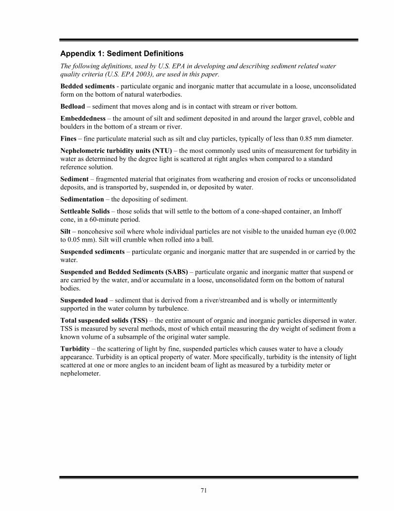
71
Appendix 1: Sediment Definitions The following definitions, used by U.S. EPA in developing and describing sediment related water quality criteria (U.S. EPA 2003), are used in this paper.
Bedded sediments - particulate organic and inorganic matter that accumulate in a loose, unconsolidated form on the bottom of natural waterbodies.
Bedload – sediment that moves along and is in contact with stream or river bottom.
Embeddedness – the amount of silt and sediment deposited in and around the larger gravel, cobble and boulders in the bottom of a stream or river.
Fines – fine particulate material such as silt and clay particles, typically of less than 0.85 mm diameter.
Nephelometric turbidity units (NTU) – the most commonly used units of measurement for turbidity in water as determined by the degree light is scattered at right angles when compared to a standard reference solution.
Sediment – fragmented material that originates from weathering and erosion of rocks or unconsolidated deposits, and is transported by, suspended in, or deposited by water.
Sedimentation – the depositing of sediment.
Settleable Solids – those solids that will settle to the bottom of a cone-shaped container, an Imhoff cone, in a 60-minute period.
Silt – noncohesive soil where whole individual particles are not visible to the unaided human eye (0.002 to 0.05 mm). Silt will crumble when rolled into a ball.
Suspended sediments – particulate organic and inorganic matter that are suspended in or carried by the water.
Suspended and Bedded Sediments (SABS) – particulate organic and inorganic matter that suspend or are carried by the water, and/or accumulate in a loose, unconsolidated form on the bottom of natural bodies.
Suspended load – sediment that is derived from a river/streambed and is wholly or intermittently supported in the water column by turbulence.
Total suspended solids (TSS) – the entire amount of organic and inorganic particles dispersed in water. TSS is measured by several methods, most of which entail measuring the dry weight of sediment from a known volume of a subsample of the original water sample.
Turbidity – the scattering of light by fine, suspended particles which causes water to have a cloudy appearance. Turbidity is an optical property of water. More specifically, turbidity is the intensity of light scattered at one or more angles to an incident beam of light as measured by a turbidity meter or nephelometer.

72
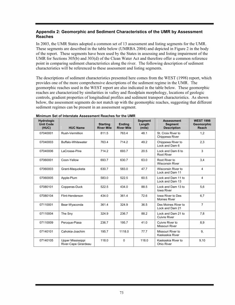
73
Appendix 2: Geomorphic and Sediment Characteristics of the UMR by Assessment Reaches In 2003, the UMR States adopted a common set of 13 assessment and listing segments for the UMR. These segments are described in the table below (UMRBA 2004) and depicted in Figure 2 in the body of the report. These segments have been used by the States in assessing and listing impairment of the UMR for Sections 305(b) and 303(d) of the Clean Water Act and therefore offer a common reference point in comparing sediment characteristics along the river. The following description of sediment characteristics will be referenced to these assessment and listing segments. The descriptions of sediment characteristics presented here comes from the WEST (1998) report, which provides one of the more comprehensive descriptions of the sediment regime in the UMR. The geomorphic reaches used in the WEST report are also indicated in the table below. These geomorphic reaches are characterized by similarities in valley and floodplain morphology, locations of geologic controls, gradient properties of longitudinal profiles and sediment transport characteristics. As shown below, the assessment segments do not match up with the geomorphic reaches, suggesting that different sediment regimes can be present in an assessment segment.
Minimum Set of Interstate Assessment Reaches for the UMR
Hydrologic Unit Code
(HUC) HUC Name Starting
River Mile Ending
River Mile
Segment Length (mile)
Assessment Segment
Description
WEST 1998 Geomorphic
Reach
07040001 Rush-Vermillion 811.5 763.4 48.1 St. Croix River to Chippewa River
1,2
07040003 Buffalo-Whitewater 763.4 714.2 49.2 Chippewa River to Lock and Dam 6
2,3
07040006 LaCrosse-Pine 714.2 693.7 20.5 Lock and Dam 6 to Root River
3
07060001 Coon-Yellow 693.7 630.7 63.0 Root River to Wisconsin River
3,4
07060003 Grant-Maquoketa 630.7 583.0 47.7 Wisconsin River to Lock and Dam 11
4
07060005 Apple-Plum 583.0 522.5 60.5 Lock and Dam 11 to Lock and Dam 13
4
07080101 Copperas-Duck 522.5 434.0 88.5 Lock and Dam 13 to Iowa River
5,6
07080104 Flint-Henderson 434.0 361.4 72.6 Iowa River to Des Moines River
6,7
07110001 Bear-Wyaconda 361.4 324.9 36.5 Des Moines River to Lock and Dam 21
7
07110004 The Sny 324.9 236.7 88.2 Lock and Dam 21 to Cuivre River
7,8
07110009 Peruque-Piasa 236.7 195.7 41.0 Cuivre River to Missouri River
8,9
07140101 Cahokia-Joachim 195.7 1118.0 77.7 Missouri River to Kaskaskia River
9,
07140105 Upper Mississippi River-Cape Girardeau
118.0 0 118.0 Kaskaskia River to Ohio River
9,10
74
St. Croix River to Chippewa River This UMR river segment includes Pool 3 and part of Pool 4, including Lake Pepin. Sediments of these pools have been described as relatively coarse and sandy, particularly in the navigation channel (FTN 1999). Due to the nature of the soils (well drained and sandy) and land use (primarily forested) in the region, tributaries entering the UMR in this assessment segment have low sediment loads that are sandy in nature (USGS 1999). These sediment loads tend to settle out quickly in the UMR, or be carried as bed load. Lake Pepin acts as a sink for fine sediments from upstream areas. There is no main channel dredging in Lake Pepin because hydrologic conditions keep the navigation channel open (FTN 1999). Low turbidity values (<25 NTU) are observed in Pool 4 (USGS 1999), and the percentage of suspended sediment in Pool 4 that is clay-sized or smaller is around 60% (WEST 1998).
Chippewa River to Lock and Dam 6 This UMR river segment includes part of Pool 4 as well as Pools 5, 5A, and 6. In Pool 4, downstream of the Chippewa River below Lake Pepin, sediments are coarse and sandy. Pools 5, 5A, and 6 are part of a relatively steep reach of the UMR that exhibited classic island-braided morphology prior to the building of the locks and dams. These pools still contain relatively high acreages of islands, although they are being eroded by wind and wave action, primarily in the lower pools (WEST 1998). This segment is also strongly influenced by the sandy sediments contributed by the Chippewa River (FTN 1999). In this segment approximately 70% of suspended sediments are clay size or smaller (WEST 1998). Lock and Dam 6 to Root River
This UMR river segment includes Pool 7. This segment is part of the relatively steep reach of the UMR that exhibited classic island-braided morphology prior to the building of the locks and dams. Pool 7 contains a high acreage of islands. While these islands are subject to erosion by wind and waves, the overall acreage of islands is remaining fairly constant as sedimentation is also creating islands (WEST 1998).
Root River to Wisconsin River
This UMR river segment includes Pools 8 and 9, and part of Pool 10. Pools 8 and 9 are part of the relatively steep reach of the UMR that exhibited classic island-braided morphology prior to the building of the locks and dams. These pools still contain high acreages of islands, although they are being eroded by wind and wave action, primarily in the lower pools. The river valley narrows in Pool 10 due to the presence of less erosive dolomite formations. In Pool 8 turbidity measurements are not significantly greater than for Pool 4 and exhibit a downward trend (USGS 1999). The percentage of suspended sediments in Pool 8 that are clay size or smaller is approximately 80%. Pools 8 and 9 exhibit a reduction in gradient due to the influence of the Wisconsin River alluvial fan. Pool 10 experiences sedimentation of the Wisconsin River sediment load (WEST 1998). Wisconsin River to Lock and Dam 11
This UMR river segment includes Pool 11 and part of Pool 10. In this segment, the Mississippi River passes through a narrow bedrock gorge that extends to the upper portion of Pool 13. Pool 11 exhibits low island acreage. Since lock Dam 11 was completed, Pool 11 has experienced up to 8 ft of sedimentation (at the lower end of the pool). This is probably the result of inputs from several moderate-sized tributaries that drain watersheds with relatively thick deposits of easily eroded loess sediment. These tributaries are estimated to contribute approximately 50% of the sediment load in Pool 11 (WEST 1998).
75
Lock and Dam 11 to Lock and Dam 13
This UMR river segment includes Pools 12 and 13. This segment of the Mississippi River flows through a narrow bedrock gorge that ends in the upper reach of Pool 13. There are no major tributaries to Pool 12, and little transport of sediment from Pool 11 (WEST 1998). A 1995 sediment budget calculated for Pool 13 estimated that approximately 67% of the sediment load came from the main stem (i.e. not tributaries), and that most of the sediment load to the pool was exported downstream (USGS 1999). Turbidity measurements in Pool 13 appear to the significantly higher than those in Pool 8 (USGS 1999). In Pool 12, approximately 95% of suspended sediments are clay size or smaller. Downstream of Lock and Dam 11 sand sized materials are transported primarily as bed load (WEST 1998).
Lock and Dam 13 to Iowa River
This UMR river segment includes Pools 14 through 17 and part of Pool 18. The lower end of Pool 14 and all of Pool 15 consist of a very steep reach that is contained within a rock gorge. These pools are morphologically very stable as a result of this geology. Relatively high water velocities and erosion resistant bedrock provide uniform conditions throughout these pools. The thalweg bottom here consists of bedrock cobbles. The area of backwater within these pools is small with correspondingly restricted area of fine sediments (FTN 1999). Downstream of Pool 15 the river gradient decreases abruptly however, the rock gorge continues into Pool 16. Pools 16 and 17 contain large islands that appear to be the result of deposition of sediments that were passed through Pools 14 and 15 with their higher velocities and that are contributed by tributaries in Pool 16 (WEST 1998). Approximately 20% of the sediment load in Pool 16 is estimated to be from tributaries, while in Pool 17 there are no tributaries contributing significant sediment load (WEST 1998).
Iowa River to Des Moines River
This UMR river segment includes Pool 19 and parts of Pools 18 and 20. Pools 18 and 19 are in a steep rock gorge. These pools receive moderate sediment loads from tributaries (20-30% of pool sediment loads). The most significant tributary source of sediment in Pool 18 is the Iowa River. In Pool 19 it is the Skunk River. In Pool 18 islands have been formed by deposition of sediment load, and are subject to wind and wave erosion. Because Dam 19 is the highest dam on the UMR, Pool 19 has accumulated the most sediment since impoundment, approximately 10 times more than the other pools (WEST 1998). In this segment, the tributary watersheds are intensively row cropped (which results in higher sediment loads than most land uses) and the sediment from these watersheds is silty and easily resuspended by waves (caused by wind or boat traffic) (USGS 1999). Just upstream of the Des Moines River approximately 99% of the suspended sediments are clay size or smaller (WEST 1998).
Des Moines River to Lock and Dam 21
This UMR river segment includes Pool 21 and most of Pool 20. These pools are morphologically very stable. This segment is strongly influenced by the high bedload of sediment from the Des Moines River (WEST 1998). Approximately 30% of the sediment load of Pool 20 comes from tributaries, including the Des Moines River. Only 3% of the sediment load of Pool 21 comes from tributaries (WEST 1998). Soils in these tributary watersheds are predominantly easily erodible loess (USGS 1999).

76
Lock and Dam 21 to Cuivre River
This UMR river segment includes Pools 22 through 25 and part of Pool 26. Significant sedimentation occurs in Pool 25, it has one of the highest annual dredge volumes in the UMR (WEST 1998). Sediment load from the Salt River contributes to sedimentation in Pool 24 (WEST 1998). In Pool 22, approximately 97% of the suspended sediment is clay size or smaller (WEST 1998). This is the farthest downstream that WEST (1998) evaluated suspended sediment size.
Cuivre River to Missouri River
This UMR river segment includes most of Pool 26 and a portion of the free-flowing river. This segment is strongly influenced by the sediment load from the Illinois River, which is primarily suspended sediment. The Illinois River contributes approximately 20% of the Pool 26 sediment load. Pool 26 experiences significant sedimentation, it also has one of the highest annual dredge volumes in the UMR (WEST 1998).
Missouri River to Kaskaskia River
This river segment is in the unimpounded portion of the UMR. This segment is strongly influenced by the alluvial fan of the Missouri River. Historically the Missouri River has introduced significant bed load to the Mississippi River (WEST 1998). The suspended sediment load of the Missouri River is much higher than the upstream load of the Mississippi River (USGS 1999, WEST 1998). WEST (1998) states that the suspended sediment load of the UMR increases by a factor of four at the confluence with the Missouri River. Compared to upstream of the Missouri River, this portion of the Mississippi River has relatively little complexity, consisting of only main channel and secondary channel areas. The extent of contiguous and isolated backwater areas is limited, and many contiguous backwater areas associated with secondary channels have been intentionally blocked. A large number of wing dams are located along this reach and the river is closely confined within levees or railroad embankments on both banks. These factors result in relatively higher channel velocities in this reach (FTN 1999) which means a greater suspended sediment load can be carried in this segment.
Kaskaskia River to Ohio River Sediment characteristics of this portion of the UMR are similar to the previous river segment (Missouri River to Kaskaskia River). It is also strongly influenced by the sediment load of the Missouri River, and exhibits the same relatively simple channel morphology and higher channel velocities due to the presence of wing dams and levees (FTN 1999). Turbidity values measured in this segment are significantly greater than those measured in Pool 26 (USGS 1999), most likely due to the Missouri River contribution and the higher flow velocities.
77
Appendix 3: UMRCC-Water Quality Technical Section Proposal: SAV Protection Criteria Proposed Water Quality Criteria Necessary to Sustain
Submersed Aquatic Vegetation in the Upper Mississippi River Upper Mississippi River Conservation Committee
Water Quality Technical Section October 2003
Submersed aquatic vegetation (SAV) is an important component of the aquatic habitat in the Upper Mississippi River (UMR) navigation pools. Leaves, seeds and vegetative propagules are a source of food for waterfowl. The submerged plants provide a substrate for invertebrate and periphyton colonization, habitat for larval and adult fish, and help stabilize fine sediments from boat waves and wind-induced sediment resuspension (Korschgen 1988 and Janecek 1988). Submersed aquatic plants have been used to assess water quality and to provide a measure of ecosystem health (Dennison et. al. 1993). We believe greater river and watershed management efforts need to be directed to protecting and enhancing SAV on the UMR. In particular, efforts to reduce the negative effects of high turbidity or suspended particulate matter during the growing season are warranted to ensure the continued survival of SAV beds within historic ranges and densities in the UMR navigation pools. To achieve this goal, we are recommending specific and consistent light-related water quality criteria be adopted by water quality management agencies having jurisdiction over the UMR that will be protective of SAV growth and reproduction. These criteria are needed for monitoring, assessing impairments, formulating river and watershed management strategies, and evaluating management efforts that seek to enhance and protect SAV beds in the UMR. We believe consistent and scientifically based criteria are necessary to help target river or watershed sources contributing to excessive turbidity or suspended particulate matter concentrations in the river. These efforts may not only help sustain and enhance SAV communities but will also help achieve goals to reduce other sediment-related impairments on the river (UMRCC 2000). Background A substantial decline in SAV in the UMR was reported following the 1987-89 drought (Kimber et al. 1995 and McFarland and Rogers 1998). Although this decline was widespread, specific field surveys documenting the decline are limited. Primary information illustrating the decline was available from federal SAV monitoring activities in Weaver Bottoms, Pool 5, and Lake Onalaska, Pool 7, (Figure 1a). In addition, a comparison of SAV in 1975 versus 1991 also revealed a substantial reduction in SAV frequency and biomass in Pool 8 (Fischer 1997). Although the specific reasons for the decline have not been established, possible causative factors include decreased light availability, nitrogen limitation, increased water temperature and hydraulic factors (Kimber et al. 1995a, Rogers et al. 1995, Sullivan 1995). Total suspended solids (TSS) monitoring in portions of the river where the SAV decline indicated summer average concentrations ranging from about 20-40 mg/L preceding and during the drought (1980-89, Figure 1b). It is difficult to accurately establish the temporal and spatial SAV response during this period due to the limited and disrupted monitoring activities. However, the available data suggests SAV was declining in Lake Onalaska in the early 1980s (1980-83) followed by a recovery just prior to the 1987-89 drought. Vast beds of SAV were still present in many UMR pools in 1987 based on a review of color aerial photographs from September 1987 and general observations by river biologists. Submersed aquatic vegetation declined precipitously in Weaver Bottoms in 1988 to 1989 and likely reflected a similar unmeasured decline that was apparent in Lake Onalaska and other areas of the UMR during this period. Following the 1987-89 drought, tributary flows increased and yielded very high TSS concentrations in the river, especially in 1990 (Figure 1b). These conditions resulted in a substantial reduction in light penetration in the
78
Mississippi River as measured by the Wisconsin Department of Natural Resources (WDNR) at Lock Dam 8 and 9 and Weaver Bottoms (Figure 2). It is recognized that the loss of the SAV also contributed to decreased light penetration as a result of increased sediment resuspension due decreased sediment stability. SAV provides resistance to sediment resuspension by dampening the impacts of waves or current velocity. However, we believe the recovery of SAV following the drought was primarily driven by the availability of adequate light energy for SAV growth and reproduction during the growing season (May-September). Since the mid- to late 1990s, SAV has increased in many areas as illustrated by Vallisneria monitoring at Lake Onalaska (Figure 1a), observations in Pool 9, and monitoring studies performed by the federal Long Term Resource Monitoring Program (LTRMP) in Pool 8 and 13 (Yao Yin, USGS, Personal Communications). In contrast, SAV has remained low in Weaver Bottoms where sediment resuspension, turbid inflows and phytoplakton contributed to reduced light penetration throughout the 1990s (Nelson 1998 and Sullivan 1996). Water Quality Criteria for Submersed Aquatic Vegetation The negative impact of high turbidity or suspended particulate matter on SAV is well known and has been documented in many systems including Lake Chatauqua, Illinois (Jackson and Starret 1959), Rice Lake Wisconsin (Engel and Nichols 1994), and Chesapeake Bay (Dennison et al. 1993). These impacts are expressed through a reduction in light energy on leaf surfaces, which contribute to reduced growth and reproduction (Korschgen et al. 1997 and Kimber et al. 1995b). The maximum depth of colonization of SAV has been directly linked to the transparency of water (Chambers and Kalff, 1985 and Canfield et al. 1985). Their regression plots of the maximum colonization depth versus Secchi disk depth are similar (Figure 3a) and suggests the relationship may have broad application to many freshwater systems. For example, this simple relationship could be used to establish the target depth for SAV establishment in the UMR navigation pools. Water quality management efforts would then be directed at controlling turbidity or suspended particulate matter to provide the necessary underwater light conditions to support SAV growth and reproduction. A similar approach has been suggested for Chesapeake Bay (Dennison et al. 1993). In order to establish light penetration-related water quality criteria to protect SAV on the river, we need to determine a reasonable colonization depth for these plants. Rather than basing this depth on some arbitrary number, this value should be based on the observed depth distributions of SAV from the navigation pools during time periods when these plants were common and flourishing. For example, Vallisneria americana (wildcelery), is an important species in the upper navigational pools on the river and has been reported at depths ranging from 0.1 to 2.8 m based on LTRMP vegetation monitoring of Pools 4, 8 and 13 during 1998 to 2001 (USGS, 2003). The median depth of occurrence was 0.8 m. Studies of Vallisneria in Pool 8 during 1983-85 indicated this plant was present at sites with a mean depth of 0.88 m (Korschgen et al. 1997). Using a target SAV colonization depth of 0.8 m and the regression equations presented in Figure 3a, a target Secchi depth transparency of approximately 0.4 m is derived. An alternative approach for criteria development would be to determine the specific light requirements of a “key” submergent species and then base the light criteria on these studies. This research has been conducted in the UMR for wildcelery and provides the most direct support for establishing criteria that will be protective of this species in the river. The results of this work are summarized below:
• "Limit suspended sediment concentrations to <20 mg/L so that the annual 1% penetration depth will be between 1 to 1.5 m. This depth should provide adequate light energy for successful growth and reproduction and enough potential habitat area for good aquatic plant distribution and diversity"
(Korschgen et al 1997). Using an average 1% depth of 1.25 m yields a light extinction
coefficient of 3.68 m-1
. • "Survival, growth, and reproduction of seedlings were significantly greater in treatments
with a least 9% of surface light availability over the growing season… These light requirements are the same as those for plants grown from" winter "buds"
(Kimber et al. 1995b). This corresponds to a light extinction coefficient of 3.01 m-1
based on the existing median depth distribution of this species in the river (0.8 m).
79
• "plants required at least 8.7% of surface light for tubers to be produced in 94
days…For a longer growing season (109 days), plants produced replacement-weight tubers in treatments with at least 5% of surface light …plants in lower light environments maybe able to produce owerwintering tubers at lower light levels if the" growing " season is sufficiently long" (Kimber et al. 1995a). Using the 5%
surface light requirement corresponds to a light extinction coefficient of 3.74 m-1
at a targeted mean water depth of 0.8 m.
Recommended Vertical Light Extinction Coefficient Criterion: Use the logarithmic
average of the above extinction coefficients (ln[(e-3.68
+e-3.01
+ e-3.74
)/3]) to obtain an average value of 3.42 m-1. This corresponds to an average compensation depth (1% of surface light) of 1.35 m. This equates to 6.5% of surface light at a depth of 0.8 m using the light penetration definition provided below. These criteria should be applied as a growing season average (May 15 -September 15) which represents the typical period of growth in the UMR (Donnermeyer and Smart 1985). These criteria reflect the minimum light criteria necessary to sustain and enhance SAV on the river. If light penetration were greater, we would anticipate greater depths of colonization. Although these criteria were derived for a single species, wildcelery, these light conditions will favor the growth and development of other SAV species as well since wildcelery establishment will contribute to reduced turbidity and improved light conditions in the riverine pools (Korschgen et al. 1997).
Note: Light penetration is defined as:
Io = Iz e-kz
or k = [ln(Io) - ln(Iz)] / z where Io = Surface or upper light measurement Iz = Light measurement at depth z e = Base of natural logarithms (2.71828…) k = Light extinction coefficient z = Depth interval between Io & Iz also by definition, the compensation depth (1% of surface light) =
(zI1%) = [ln(100) - ln (1)] / k or 4.605 / k Comparing the recommended compensation depth (1.35 m) to an average of measurements made in the Mississippi River at Lock and 8 and 9 by the WDNR over the last 15 years indicates this value was not achieved between 1989 and 1996 (Figure 3b) and generally corresponds with a period of reduced SAV on the river. Since 1996, the recommended compensation depth has been achieved and is consistent with the observed recovery of SAV in Pools 7, 8 and 9 in the last several years. In contrast, average July and August light penetration measurements made by the WDNR in Weaver Bottoms indicate a substantially longer period of reduced light penetration. The average of July and August compensation depth measurements at Weaver Bottoms started to exceed the recommended value in 2001 and 2002. To date, SAV has not recovered on Weaver Bottoms and has generally lagged behind other areas of the river, including the eastern portion of Pool 5, which exhibits greater transparency (Nelson 1998). Increased SAV on Weaver Bottoms would be expected in the future if favorable light penetration persists during the next few summer seasons.
80
Conversion of Recommended Light Extinction Coefficient Criterion to Secchi Disk Depth, Total Suspended Solids or Turbidity Measurements Few water quality monitoring programs measure light penetration directly using underwater light sensing
equipment. In order to convert the recommended light extinction coefficient criterion (3.42 m-1
) to commonly measured field or laboratory variables, the relationship between light extinction and relevant water quality variables (Secchi depth, turbidity and total suspended solids) need to be described for the Mississippi River. These relationships have been established based on long term water quality monitoring conducted on the Mississippi River by the WDNR or through monitoring conducted by the federal Long Term Resource Monitoring Program (LTRMP), (Figure 4a,b, & c). Based on regression equations provided in these figures, a listing of the recommended surrogate light penetration-related water quality criteria are provided in Table 1. Table 1. Recommended light-related water quality criteria necessary to support and sustain submersed aquatic vegetation in the Upper Mississippi River. Variable
Value*
Basis
Light Extinction Coefficient
3.42 m-1
Average growing season light extinction necessary to promote Vallisneria growth and reproduction at 0.8 m depth
Secchi Disk Depth
0.5 m
Light extinction vs Secchi depth regression, WDNR data for Pools 4-11
Total Suspended Solids
25 mg/L
Light extinction vs TSS regression - WDNR data for Lock & Dam 8 & 9
Turbidity
20 ntu
Light extinction vs turbidity regression - LTRMP data for Pools 8 & 13.
* Values should be applied as a growing season average (May 15 to September 15) based on bi-weekly measurements. A comparison of the 0.5 m Secchi depth criterion to transparency measurements made throughout the UMR System by the federal LTRMP indicate this value is not achieved in the lower portion of the UMR and in the Illinois River (La Grange Pool), (Figure 5). The results are consistent with the observed distribution of LTRMP wildcelery data that indicate an absence of this species at sites failing to meet this criterion. In addition, average summer turbidity measurements generally meet or approach the 20 ntu criterion where wildcelery is found but are absent from study reaches where this value is exceeded (Pool 26, Open River and the LaGrange Pool on the Illinois River), (USGS 2003). Recommendations for Submersed Aquatic Vegetation Projection and Managment The primary application of the above light criteria are intended for those portions of the UMR system where SAV has been historically found. It is recognized that SAV establishment will not be possible throughout the entire river due to natural factors (velocity, depth, high turbidity levels and other factors) that prevent SAV growth and development. These considerations will be necessary when applying these criteria to the UMR System. The use of the above criteria should be considered for habitat projects where SAV development and protection are important habitat objectives.
81
We believe State water quality management agencies should consider the above water quality criteria for Mississippi River as well as tributary streams discharging to reaches where SAV development and protection have been identified as important management objectives or goals. These criteria should be considered when assessing surface waters as part of biannual assessments (section 305b reporting) or when defining water quality impairments (section 303d). Attainment of the light penetration criteria in the UMR will not only improve habitat conditions for SAV but will also help meet identified goals for reducing sediment related problems on the UMR and its backwaters (UMRCC 2002). Although we believe improving and maintaining an adequate underwater light penetration is critical for SAV growth and survival, we understand that other factors (water level changes, waves, nutrients, floods, substrate composition and herbivore activity and other factors) also play a role in governing the development and persistence of SAV communities on the river. Continued monitoring and research are warranted to further our understanding of factors controlling SAV distribution and abundance on the river. In particular, the response of SAV to ongoing water level management activities, changes in river flow, nutrient enrichment, habitat rehabilitation projects or other human-induced disturbances on the river need to be explored. The negative impacts of excessive nutrient enrichment in enhancing filamentous algae or epiphytic plant growth on SAV may be especially important since these attached plants have been implicated as a critical factor contributing to submersed aquatic macrophyte declines in freshwater systems (Phillips et al. 1978). Their work suggests excessive canopies of filamentous algae and other attached algae may lead to increased competition for light and nutrients and may promote the "switch" from a SAV dominated system to one dominated by algae. Current efforts by states and EPA to address nutrient criteria in lakes and rivers should consider nutrient-related impairments on SAV communities.
References Canfield, D.E., Langeland, K.A., Linda, S.B., and Haller. W.T. 1985. Relations between water transparency and
maximum depth of macrophyte colonization in lakes. J. Aquat. Plant Mgt. 23:25-28. Chambers, P.A. and Kalff, J. 1985. Depth distribution and biomass of submersed aquatic macrophyte
communities in relation to Secchi depth. Can. J. Fish. Aquat. Sci. 42:701-709. Dennison, W.C., Orth, R.J., Moore, K.A., Stevenson, J.C., Carter, V., Kollar, S., Bergstrom, P.W., and Batiuk,
R.A. 1993. Assessing water quality with submersed aquatic vegetation. Habitat requirements as a barometer of Chesapeake Bay health. BioScience 43:86-94.
Donnermeyer, G. N. and Smart, M.M. 1985. The biomass and nutritive potential of Vallisneria americana Michx in
Navigation Pool No. 9 of the Upper Mississippi River. Aquat. Bot., 22:33-44. Fischer, J.R. 1995. Declines in aquatic vegetation in Navigation Pool No. 8, Upper Mississippi River, between
1975 and 1991. M.S. thesis submitted to the faculty of the graduate school of the University of Wisconsin-La Crosse. Reprinted by U.S. Geological Survey, Environmental Management Technical Center, Onalaska, Wisconsin, March 1977. LTRMP 97-R003. 47 pp.
Jackson, H.O. and Starret, W.C. 1959. Turbidity and sedimentation at Lake Chautauqua, Illinois. J. Wild. Mgt.
23:157-168
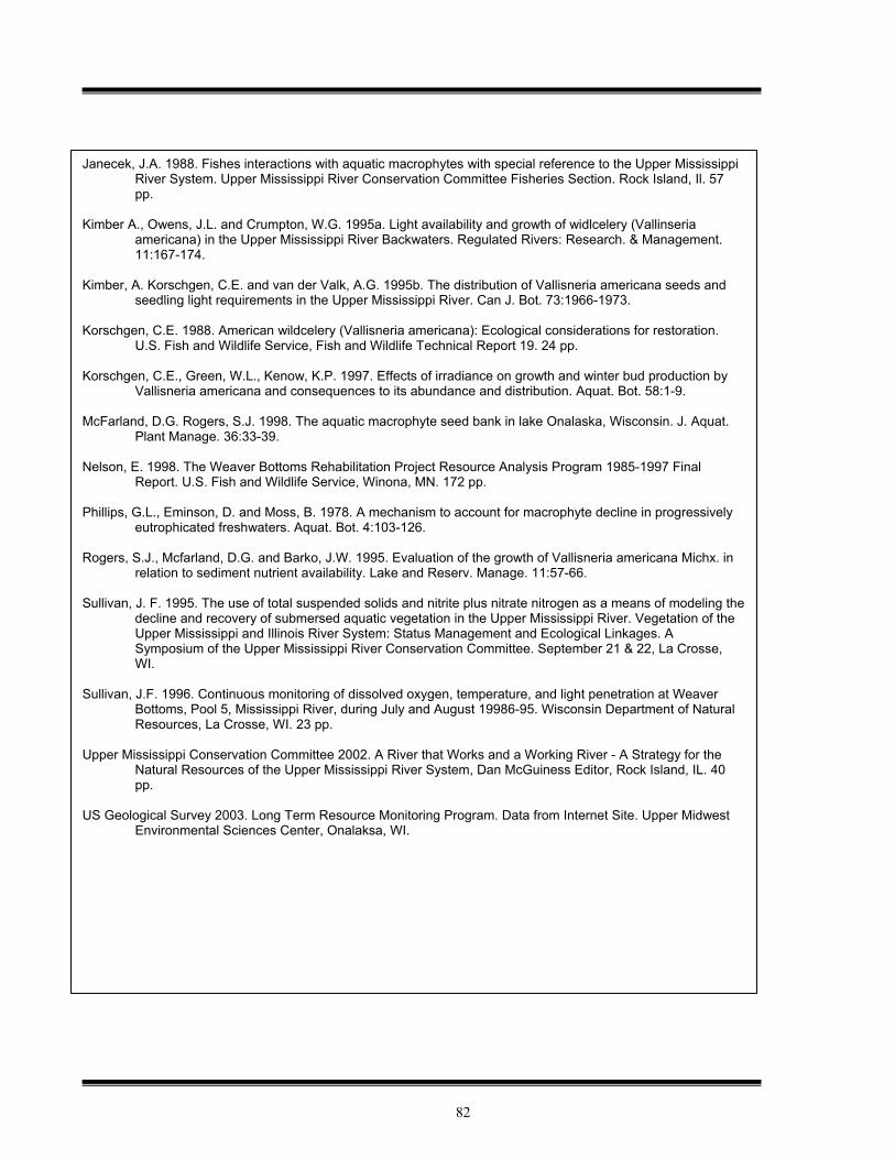
82
Janecek, J.A. 1988. Fishes interactions with aquatic macrophytes with special reference to the Upper Mississippi River System. Upper Mississippi River Conservation Committee Fisheries Section. Rock Island, Il. 57 pp.
Kimber A., Owens, J.L. and Crumpton, W.G. 1995a. Light availability and growth of widlcelery (Vallinseria
americana) in the Upper Mississippi River Backwaters. Regulated Rivers: Research. & Management. 11:167-174.
Kimber, A. Korschgen, C.E. and van der Valk, A.G. 1995b. The distribution of Vallisneria americana seeds and
seedling light requirements in the Upper Mississippi River. Can J. Bot. 73:1966-1973. Korschgen, C.E. 1988. American wildcelery (Vallisneria americana): Ecological considerations for restoration.
U.S. Fish and Wildlife Service, Fish and Wildlife Technical Report 19. 24 pp. Korschgen, C.E., Green, W.L., Kenow, K.P. 1997. Effects of irradiance on growth and winter bud production by
Vallisneria americana and consequences to its abundance and distribution. Aquat. Bot. 58:1-9. McFarland, D.G. Rogers, S.J. 1998. The aquatic macrophyte seed bank in lake Onalaska, Wisconsin. J. Aquat.
Plant Manage. 36:33-39. Nelson, E. 1998. The Weaver Bottoms Rehabilitation Project Resource Analysis Program 1985-1997 Final
Report. U.S. Fish and Wildlife Service, Winona, MN. 172 pp. Phillips, G.L., Eminson, D. and Moss, B. 1978. A mechanism to account for macrophyte decline in progressively
eutrophicated freshwaters. Aquat. Bot. 4:103-126. Rogers, S.J., Mcfarland, D.G. and Barko, J.W. 1995. Evaluation of the growth of Vallisneria americana Michx. in
relation to sediment nutrient availability. Lake and Reserv. Manage. 11:57-66. Sullivan, J. F. 1995. The use of total suspended solids and nitrite plus nitrate nitrogen as a means of modeling the
decline and recovery of submersed aquatic vegetation in the Upper Mississippi River. Vegetation of the Upper Mississippi and Illinois River System: Status Management and Ecological Linkages. A Symposium of the Upper Mississippi River Conservation Committee. September 21 & 22, La Crosse, WI.
Sullivan, J.F. 1996. Continuous monitoring of dissolved oxygen, temperature, and light penetration at Weaver
Bottoms, Pool 5, Mississippi River, during July and August 19986-95. Wisconsin Department of Natural Resources, La Crosse, WI. 23 pp.
Upper Mississippi Conservation Committee 2002. A River that Works and a Working River - A Strategy for the
Natural Resources of the Upper Mississippi River System, Dan McGuiness Editor, Rock Island, IL. 40 pp.
US Geological Survey 2003. Long Term Resource Monitoring Program. Data from Internet Site. Upper Midwest
Environmental Sciences Center, Onalaksa, WI.
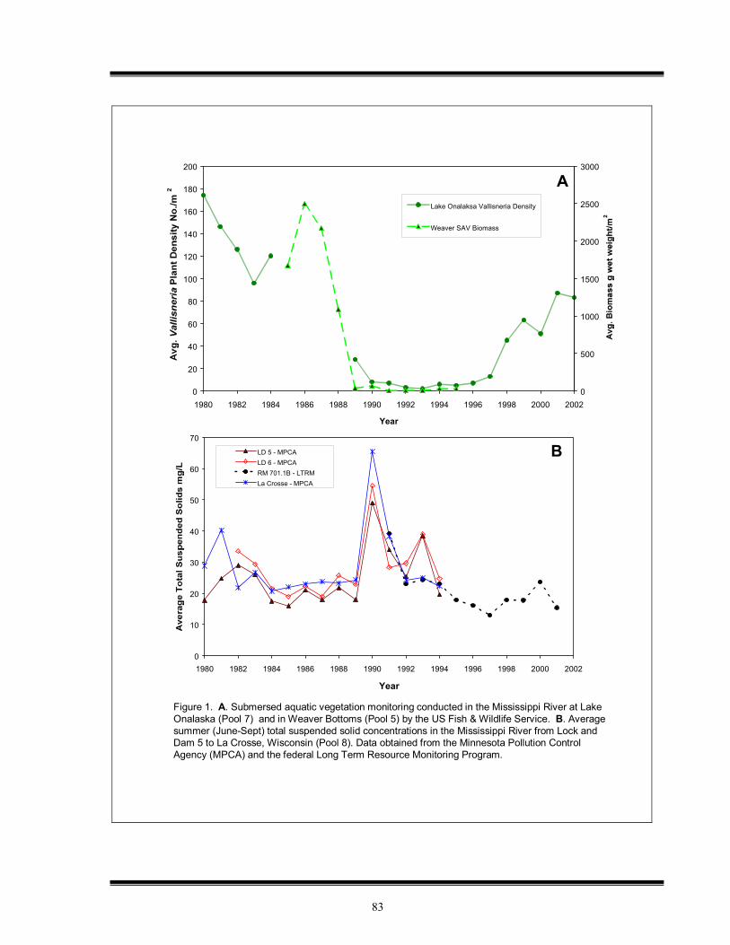
83
0
10
20
30
40
50
60
70
1980 1982 1984 1986 1988 1990 1992 1994 1996 1998 2000 2002
Year
LD 5 - MPCALD 6 - MPCARM 701.1B - LTRMLa Crosse - MPCA
0
20
40
60
80
100
120
140
160
180
200
1980 1982 1984 1986 1988 1990 1992 1994 1996 1998 2000 2002
Year
0
500
1000
1500
2000
2500
3000
Lake Onalaksa Vallisneria Density
Weaver SAV Biomass
A
B
Figure 1. A. Submersed aquatic vegetation monitoring conducted in the Mississippi River at Lake Onalaska (Pool 7) and in Weaver Bottoms (Pool 5) by the US Fish & Wildlife Service. B. Averagesummer (June-Sept) total suspended solid concentrations in the Mississippi River from Lock andDam 5 to La Crosse, Wisconsin (Pool 8). Data obtained from the Minnesota Pollution ControlAgency (MPCA) and the federal Long Term Resource Monitoring Program.
84
Figure 2. Average light penetration measurements in the Mississippi River during July and Augustat Weaver Bottoms (Pool 5) and June-September at Lock and Dam 8 & 9. Data collected by the Wisconsin Department of Natural Resources. Light penetration measurements represent the 1% depth of surface photosynthetically active radiation (PAR).
0.00
0.50
1.00
1.50
2.00
2.50
3.00
3.50
86 87 88 89 90 91 92 93 94 95 96 97 98 99 0 1 2
Year
Weaver Bottoms July Avg. Site 1
Weaver Bottoms Aug. Avg. Site 2
LD 8 July-Sept. Avg.
LD 9 July-Sept. Avg.

85
0.0
0.5
1.0
1.5
2.0
2.5
3.0
3.5
0 0.25 0.5 0.75 1 1.25 1.5 1.75 2 2.25
Secchi Depth m
Canfield et al. 1985
Chambers and Kalff 1985
log (y) = 0.79 log (Secchi) + 0.25
y 0.5 = 1.33 log (Secchi) + 1.4
A
Figure 3. A. Reported relationships between the maximum submersed aquatic vegetation(SAV) depth and Secchi depth transparency. B. Average light penetration measurementsmade by the Wisconsin Department of Natural Resources at Lock and Dam 8 & 9 and WeaverBottoms (Pool 5) in comparison to the recommended light penetration criterion ( average summer 1% depth > 1.35 m) to support submersed aquatic vegetation in the Mississippi River.
0.00
0.25
0.50
0.75
1.00
1.25
1.50
1.75
2.00
1988 1990 1992 1994 1996 1998 2000 2002
Year
Avg. for Lock and Dam 8 & LD 9
Avg. for Weaver Bottoms
Recommended Light Penetration Criterionfor Submersed Aquatic Vegetation
Period of low light penetration at Lock and Dam 8 & 9
Period of low light penetration in Weaver Bottoms
Vallisneria recovery in Lake Onalaska
B
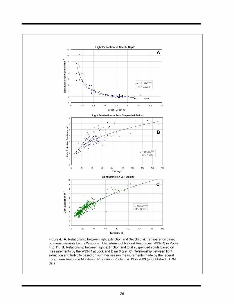
86
Light Extinction vs Secchi Depth
y = 1.8192x-0.8679
R2 = 0.9239
0
2
4
6
8
10
12
14
16
18
0 0.2 0.4 0.6 0.8 1 1.2 1.4 1.6
Secchi Depth m
Light Penetration vs Total Suspended Solids
y = 0.9513x0.3971
R2 = 0.6394
0
1
2
3
4
5
6
7
8
0 20 40 60 80 100 120 140 160 180
TSS mg/L
A
B
Figure 4. A. Relationship between light extinction and Secchi disk transparency based on measurements by the Wisconsin Department of Natural Resources (WDNR) in Pools4 to 11. B. Relationship between light extinction and total suspended solids based onmeasurements by the WDNR at Lock and Dam 8 & 9. C. Relationship between lightextinction and turbidity based on summer season measurements made by the federalLong Term Resource Monitoring Program in Pools 8 & 13 in 2003 (unpublished LTRMdata).
Light Extinction vs Turbidity
y = 0.6995x0.5325
R2 = 0.8195
0
1
2
3
4
5
6
7
8
9
10
0 20 40 60 80 100 120 140 160
Turbidity ntu
C
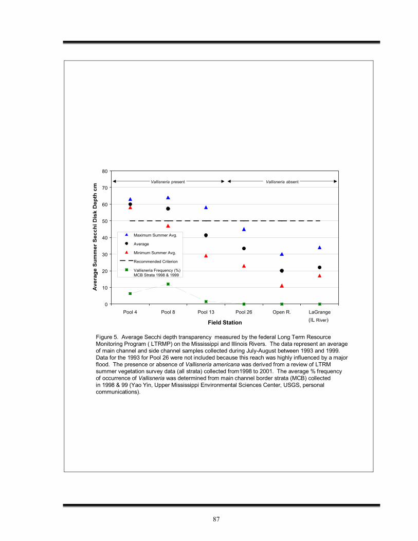
87
Figure 5. Average Secchi depth transparency measured by the federal Long Term ResourceMonitoring Program ( LTRMP) on the Mississippi and Illinois Rivers. The data represent an averageof main channel and side channel samples collected during July-August between 1993 and 1999. Data for the 1993 for Pool 26 were not included because this reach was highly influenced by a majorflood. The presence or absence of Vallisneria americana was derived from a review of LTRMsummer vegetation survey data (all strata) collected from1998 to 2001. The average % frequencyof occurrence of Vallisneria was determined from main channel border strata (MCB) collectedin 1998 & 99 (Yao Yin, Upper Mississippi Environmental Sciences Center, USGS, personal communications).
0
10
20
30
40
50
60
70
80
Pool 4 Pool 8 Pool 13 Pool 26 Open R. LaGrange
Field Station
Maximum Summer Avg.
Average
Minimum Summer Avg.
Recommended Criterion
Vallisneria Frequency (%)MCB Strata 1998 & 1999
Vallisneria present Vallisneria absent
(IL River)

88
89
Appendix 4: Draft MOU
Purpose
The purpose of this agreement is to initiate the pursuit of consistent and compatible sediment-related water quality criteria on the Upper Mississippi River and to express the mutual commitment of the signatory States and the U.S. Environmental Protection Agency to seeking consistency in sediment-related impairment listings on the Upper Mississippi River. Findings
Regarding the Upper Mississippi River as an Interstate Resource:
The Upper Mississippi River is a precious natural resource of both regional and national significance. The river’s economic and environmental importance is evidenced by its ecologically rich fish and wildlife habitat and its use for municipal, industrial, and agricultural water supplies; commercial navigation; hydroelectric power and energy production; recreation; and mining.
The Upper Mississippi River is an interstate waterbody that both forms the boundary between States and transports water and pollutants from upstream States to downstream States. In addition, the Mississippi River is a large floodplain river system that has been structurally altered, affecting its flow and ecological structure. In combination, these factors present significant scientific and management challenges. Regarding the Roles of the States, U.S. EPA, and the UMRBA in Clean Water Act Implementation:
The States of Illinois, Iowa, Minnesota, Missouri and Wisconsin, in partnership with the U.S. Environmental Protection Agency, share a continuing responsibility for protecting and enhancing the water quality of the Upper Mississippi River. Effective water quality monitoring, assessment, and management on the Upper Mississippi River require enhanced coordination of existing activities.
The States and U.S. EPA, through the Upper Mississippi River Basin Association (UMRBA) Water Quality Task Force and Water Quality Executive Committee, are working to facilitate compatibility and consistency in approaches to water quality protection on the Upper Mississippi River, and to better coordinate individual States’ Clean Water Act activities. As a result of these efforts, the basin States have established uniform interstate reaches of the Upper Mississippi River for assessment and impairment listing purposes. The Task Force is now pursuing greater consistency and compatibility in other aspects of the States’ Clean Water Act responsibilities on the Upper Mississippi River. Regarding Efforts to Address Sediment on the Upper Mississippi River:
Sediment from upland and streambank erosion, as well as re-suspension within the system, negatively impacts the water quality and ecological health of portions of the Upper Mississippi River. Impacts include turbidity, related to suspended sediments, and sediment deposition in the main channel, backwaters and side channels.
Addressing sediment-related water quality problems on the Upper Mississippi River is challenging for a variety of reasons, including: the modification of the river for navigation and associated impacts on sediment regimes, variability in sediment transport and loading rates, gaps in sediment-related data, as well as the potential scope and complexity of remedies to identified problems.
Despite its potential complexity and challenges, development of consistent and compatible sediment-related water quality criteria for the Upper Mississippi River is critical to the States’ ability to jointly protect and enhance the river’s water quality and designated uses.
Memorandum of Understanding: Sediment-Related Water Quality Criteria for the Upper Mississippi River October 2006
90
THEREFORE, the parties agree as follows:
1) To work through the Upper Mississippi River Basin Association Water Quality Task Force and Water Quality Executive Committee in pursuit of consistent and compatible approaches to sediment-related water quality criteria on the Upper Mississippi River.
2) To ensure that their agency fully participates in meetings and deliberations of the Water Quality Task Force related to this agreement.
3) To support and help execute the work plan outlined below.
4) To seek to integrate, to the extent possible and authorized by law, the work of the Upper Mississippi River Basin Association Water Quality Task Force regarding sediment-related water quality criteria, into their Clean Water Act programs.
5) To periodically review this Memorandum of Understanding and revise as needed.
UMRBA Water Quality Task Force Work Plan for Sediment-Related Water Quality Criteria Short-Term Activities* 1. Develop a Guidance Document Addressing Suspended Sediments
• The document will be guidance only at this point, and is not intended to require changes to state statute or rules. The guidance is intended to be used by states, at their discretion, in Clean Water Act assessment and/or impairment decisions.
• The guidance is intended to protect aquatic life uses on the Upper Mississippi River (UMR), and other beneficial uses identified by States during the process of guidance development.
• The document will initially provide the most specific guidelines in the area where the greatest understanding currently exists (i.e. addressing suspended sediments on the UMR from the St. Croix River to Lock & Dam #13).
• Where appropriate, the guidance will use the submerged aquatic vegetation protection criteria developed by the Upper Mississippi River Conservation Committee.
• The guidance will also, to the extent possible, document the linkages between suspended sediment, submerged aquatic vegetation, and other aquatic life (such as fish, birds, and insects).
2. Prepare a “White Paper” To Further Examine Issues Related to Sedimentation/Bedded Sediments
• The white paper will provide a summary of existing knowledge regarding sedimentation on the UMR, and its impacts on habitat and aquatic life uses.
• The white paper will evaluate alternative impairment categorization (i.e. “pollutant” vs. “pollution”) for sedimentation-related impairments.
• The white paper will explore the relationship between water quality impairment decisions, TMDLs, and the Corps of Engineers’ habitat restoration programs, such as the Environmental Management Program (EMP) and Navigation and Ecosystem Sustainability Program (NESP), with regard to sedimentation problems.
• The white paper is intended to serve as a basis for further discussion and potential action by the Task Force regarding sedimentation-related water quality criteria.
3. Develop a Research Needs List
• This will be a comprehensive list of research needs related to both suspended sediments and sediment deposition/bedded sediments on the UMR.
• The research needs list will also provide an opportunity to begin to lay out needs associated with the development of an index of biological integrity related to sediments, or other habitat-based, sediment-related assessment approach for the UMR.
Ongoing and Long Term Activities 1. Periodic Review of Guidance
The Task Force shall periodically review and update the suspended sediments guidance described above. This review may result in expansion of the guidance to bedded sediments or areas of the river south of Lock & Dam #13, as information becomes available in these areas. 2. Continued Investigation by the Task Force and Encouragement of Research by Others
The Task Force shall periodically review newly created or available research and shall, to the extent possible, encourage the research of others into sediment, sedimentation, and sediment-related impacts on water quality and aquatic life.
*Short-term activities are targeted for completion within approximately one year of the signing of this agreement.
91
_________________________________ ________________________________ Marcia Willhite Wayne Gieselman Bureau Chief Division Administrator Division of Water Pollution Control Environmental Sciences Division Bureau of Water Iowa Department of Natural Resources Illinois Environmental Protection Agency _________________________________ ________________________________ Leo Raudys Dan Schuette Deputy Commissioner Director Minnesota Pollution Control Agency Division of Environmental Quality
Missouri Department of Natural Resources _________________________________ ________________________________ Todd Ambs Jo Lynn Traub Administrator Director Division of Water Water Division Wisconsin Department of Natural Resources United States Environmental Protection
Agency, Region 5 _________________________________ U. Gale Hutton Director Environmental Services Division United States Environmental Protection Agency, Region 7

92
93
Appendix 5: Preliminary Investigation and Research Needs List The items listed below represent an initial attempt to summarize areas related to the development of sediment-related water quality criteria where further information and/or effort is needed. In some cases, these may areas where original research is required. In other cases, the information may exist, but has simply not been identified or examined by the WQTF to date. The WQTF expects to develop a more refined research needs as part of its continued efforts to address sediment-related water quality criteria. Additionally, some of these questions may be addressed more fully as the WQTF develops its “white paper” on sedimentation. Sediment Sources, Transport, and Deposition Enhanced understanding of sediment equilibrium on the UMR to investigate whether the river is
likely to reach post-impoundment equilibrium or whether sediment characteristics will remain dynamic for the foreseeable future. Also, improved understanding of what equilibrium conditions may be for individual pools, if equilibrium indeed appears to be likely.
Better characterization of sediment sources, transport, and deposition on the UMR, including additional sedimentation rate/bathymetry data to allow sediment aggradation and degradation rates to be more comprehensively estimated, particularly in backwater areas. An eventual goal is the development of sediment budgets for all UMR pools.
Sediment Impacts to Aquatic Life on the UMR Identification of priority species (vertebrate, invertebrate, and/or vegetation) which are to be
protected from adverse sediment impacts in support of the UMR’s aquatic life use designation. The desired ranges of these species would also need to be established.
Further examination of fish species directly impacted by sediment and how their populations and population distributions may vary with concentrations of sediment-related parameters. This examination would take into account both direct effects on fish, as well as impacts on reproductive success due to backwater sedimentation. Also would include establishing the historic and desired ranges for fish populations.
More research that links observed sediment parameters to specific impacts on aquatic life on the UMR, particularly in regard to vertebrates. This may require paired monitoring of physical and biological parameters. Consideration of timing and duration of exposure needs to be taken into account in such studies.
Better definition and quantification of linkages between SAV occurrence and prevalence/distribution of fish and waterfowl on the UMR. Also, determining the historic range of SAV occurrence and/or the desired range for SAV occurrence.
Examining further the relationships between sediment, fish, and mussel populations. This includes specifically identifying important host fish on the UMR, whether they are being impacted by sediments, and any related changes in mussel populations.
Measurement Investigation to determine which of the available options for measurement of suspended sediment
(turbidity, TSS, transparency) is most effective, appropriate, and cost-effective for the UMR.
Determination of appropriate measurements of sedimentation and/or bed characteristics on the UMR that can be related to aquatic life impacts.
Investigation of the possibility of developing biological and/or habitat measures which are related to suspended or bedded sediment.
94
General/Other Expanding both biological and physical parameter measurements in pools which are not included in
LTRMP monitoring.
Review recently gathered EMAP-GRE data for the UMR for information relevant to sediment-related water quality criteria development and preferred monitoring approaches.