Embed Size (px)
Citation preview

IV. FORMS – APPLICATIONS - PERMITS

FORMS
TABLE OF CONTENTS
1. Application for Non-Discharge Permit
2. Wastewater Allocation Request
3. Domestic Wastewater Sewer Service Application
4. Record or “As-Built” Drawing Checklist
5. Requirements for Easement Survey Plats
6. Public Gravity/Pump Collection System Plan Sheet Checklist
7. NCDENR Watershed Classification Attachment for Sewer Systems
8. Final Inspection Approval
9. Engineer’s Certificate of Completion
10. Contractor’s Certificate of Completion and Warranty
11. Easement Requirements
12. Off-Site Easement Agreement Example
13. Conveyance of Sewer System and Easement

APPLICATION FOR NON-DISCHARGE PERMIT
GRAVITY SEWER SYSTEM EXTENSION METROPOLITAN SEWERAGE DISTRICT OF BUNCOMBE COUNTY, NORTH CAROLINA
Project Name
MSD Project Number
Project Type: New Construction Relocation Modification of Permit
Wastewater Allocation Approval Number Approved G.P.D.
Wastewater Treatment Plant receiving wastewater: Metropolitan Sewerage District Of Buncombe County, North Carolina (NC0024911)
Nature of wastewater % Domestic % Industrial
% Commercial % Other
Origin of wastewater Subdivision Commercial School
Apartments/Condo(s) Industrial Other
List any parameter and it’s concentration that will be greater than normal domestic levels:
If wastewater is non-domestic, describe level of pretreatment:
If a pretreatment permit is required, has one been issued? YES NO
Has Engineer determined N.C.D.W.Q. and M.S.D. minimum design standards are met by this project? YES NO
Complete name and address of Engineering Design Firm:
Telephone - -
Professional Engineer’s Certification:
I, , attest this application for has been reviewed by me and is accurate and complete to the best of my knowledge. I further attest to the
best of my knowledge the proposed design has been prepared in accordance with the applicable regulations. Although certain
portions of this submittal package may have been developed by other professionals, inclusion of these materials under my
signature and seal signifies I have reviewed this material and have judged it all to be consistent with the proposed design.
North Carolina Professional Engineer’s Seal, Signature, and Date: Owner’s Name (print)
Owner’s signature: _________________________________________Date:
MSD will accept ownership of this system upon acceptance by the MSD Board of Directors
SEE http://www.msdbc.org FOR CURRENT RATES. Complete owner’s agreement on back side Rev. 081611

OWNER’S AGREEMENT
PROJECT NAME:
PROJECT LOCATION:
MSD PROJECT #:
ALLOCATION #:
PIN#:
NOTE: This agreement must be executed and returned to MSD as part of the plan submittal package. Plan approval will not be issued until a fully executed agreement is on file with the Planning and Development/Engineering department as part of the project file. Copies of all correspondence will be forward to the party signing this agreement.
I , hereby certify that I am the project owner and the party contractually obligated for all costs associated with installation of the sewer system. This includes the acquisition of any and all on-site and off-site sewer easements that may be required and all other required documentation to complete sewer system transfer to MSD. Construction of and documentation for said sewer system will be provided in accordance with prevailing MSD standards and specifications for developer constructed sewer systems. Issuance of building permits for this project will require evidence of approval by MSD. A certificate of occupancy will not be issued until the following MSD
requirements have been satisfied.
1. Record/As-built drawings 2. Easement/System conveyance documents 3. Engineer’s certification 4. Contractor’s certification 5. MSD inspection approval
By my signature below, I acknowledge and agree to the terms outlined in this Owner’s Agreement.
This the day of , 20 .
Signature of owner:
Owner Name (Printed): Address:
Telephone: Fax:
E-mail address:
Revised 3-28-2013

Page 1 Revision date: August 12,2015
Wastewater Allocation Request
Complete all appropriate items and return to: MSD / Planning and Development2028 Riverside Drive Asheville, NC 28804 828-254-9646Attention: Kay Farlow, [email protected] 1) Person requesting Allocation – (party to receive allocation letter) Name: _______ Address: ______ Phone: ____________ Company: ______ 2) Developer Information:Name: __________________________________________________________________ Address: __________________________________________________________________ Phone: __________________________________________________________________ Company: __________________________________________________________________ 3) Name and Location Information:Name of project: ______ PIN #: ____________ Street: ____________ 4) Scope of Project and Connection point with manhole number______________________Brief description of project: _______
_______ _____________________________________________________________________________

Page 2 Revision date: August 12,2015
Residential: # of units ______ # of bedrooms ____ Non-residential: # of employees ______ # of seats____ Estimate Discharge: ____________________GPD *(100 gallons per bedroom)* 4) Connection Information: Tap size: (circle) 4 6 8 Other _______ 5) Water Source: ____________________________________________________________
Return completed application and a $170.00 non-refundable check payable to MSD of Buncombe County to MSD Planning and Development Attention: Kay Farlow, [email protected]. The District reserves the right, in its sole and absolute discretion, to approve or decline all allocation approval requests. Name: ___________ Date: _______ ______ Signed
~Protecting Our Natural Resources~ 2028 RIVERSIDE DRIVE, ASHEVILLE, NORTH CAROLINA 28804 TELEPHONE: (828)254-9646 FAX: (828)251-4788 WEBSITE: www.msdbc.org
Provide the following information: □ A site plan showing properties to be served □ Plan showing proposed route to existing MSD sewer with topographic information □ Connection point to MSD sewer The Metropolitan Sewerage District will only consider gravity sewer extensions to the existing District sewerage system.

Effective 08/01/2018
DOMESTIC WASTEWATER SEWER SERVICE APPLICATION METROPOLITAN SEWERAGE DISTRICT OF BUNCOMBE COUNTY, NORTH CAROLINA
MSD must approve all new connections to the District Sewerage System in accordance with North Carolina Law. "New sewer connections" include any new construction to be connected to the District Sewerage System, mobile homes to be connected to the District Sewerage System and additions or alterations to existing wastewater flow. The applicant for wastewater service is responsible for obtaining any necessary rights of way (deeded easements) for sewer service between the applicant's property and the connection to the District Sewerage System. If there are any sewer lines located on the property, it is the owner's responsibility to identify and locate the sewer lines to ensure that no structures or other improvements are located in violation of North Carolina Law. Contact MSD for assistance in locating the sewer lines. MSD reserves the right to rescind any approval of this application and any allocation of wastewater flow if any information on this application is incorrect or if MSD is prohibited by the State of North Carolina or EPA from accepting additional flows.
OWNER NAME: _______________________________
MAILING ADDRESS: ___________________________ (WITH ZIP CODE)
___________________________
SERVICE ADDRESS: ___________________________ (WITH ZIP CODE)
___________________________
DIRECTIONS TO PROPERTY: ___________________
_____________________________________________
_____________________________________________
PIN #: ____________________________________________
CONTACT NAME: __________________________________
CONTACT NUMBER(S): _____________________________
__________________________________________________
CONTACT E-MAIL: _________________________________
PROJECT NAME: _________________________________
LOT #: __________________________________________
PROJECT/ALLOCATION #: _________________________
_____________________________________________
CHECK IF APPLICABLE: FOOD SERVICE ASHEVILLE CITY LIMITS OTHER ________________________________
TAP CONNECTION STATUS: TO BE INSTALLED EXISTING (It is the APPLICANT’s responsibility to verify existing tap.)
CONNECT TO: MSD SEWER PRIVATE SEWER SYSTEM __________________________________________ (List name of responsible homeowner, developer, etc.)
TAP IS NEEDED: : ASAP WILL CALL (828) 255-0061 WHEN READY
SEWER TAP SIZE:________ INCH NUMBER OF NEW WATER ACCOUNTS:________ WATER METER SIZE: ________ INCH
WATER SOURCE: ASHEVILLE BILTMORE FOREST BLACK MOUNTAIN CANE CREEK CHRISTMOUNT MONTREAT RIDGECREST WEAVERVILLE WELL WOODFIN
NUMBER OF UNITS
RESIDENTIAL or COMMERCIAL (Briefly describe proposed project)
NUMBER OF BEDROOMS
AMOUNT OF FACILITY FEE
Sewer Connection (Tap) Fees (*) This fee is to provide new or re-establish existing service connection to the MSD system.
MSD-INSTALLED TAP FEE: $1,300 NUMBER OF TAPS:_______ AMOUNT OF TAP FEES: ________________
DEVELOPER/CONTRACTOR-INSTALLED TAP INSPECTION FEE: $140 NUMBER OF TAPS:_____ AMOUNT OF INSPECTION FEES: __________
PAVEMENT DISTURBANCE/BORE FEE: $2,300 NUMBER OF CUTS/BORES:_______ AMOUNT OF CUT/BORE FEES: ________________
TOTAL FEES: ____________________
SIGNATURE: ______________________________________________ DATE SIGNED: _______________________
Effective 08/01/2018
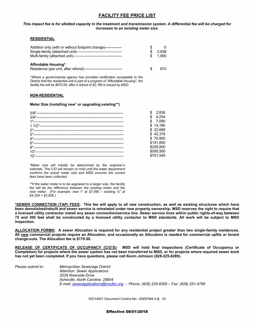
FACILITY FEE PRICE LIST
This impact fee is for allotted capacity in the treatment and transmission system. A differential fee will be charged for increases to an existing meter size.
RESIDENTIAL
Addition only (with or without footprint change)-------------- Single-family (detached unit)-------------------------------------- Multi-family (attached unit)-----------------------------------------
Affordable Housing* Residence (per unit, after refund)--------------------------------
*Where a governmental agency has provided certification acceptable to theDistrict that the residential unit is part of a program of “Affordable Housing”, thefacility fee will be $670.00, after a refund of $2,166 is issued by MSD.
$ 0 $ 2,836 $ 1,900
$ 670
NON-RESIDENTIAL
Meter Size (installing new* or upgrading existing**)
5/8"------------------------------------------------------------------------ 3/4"------------------------------------------------------------------------ 1"--------------------------------------------------------------------------- 1 1/2"---------------------------------------------------------------------- 2"--------------------------------------------------------------------------- 3"--------------------------------------------------------------------------- 4"--------------------------------------------------------------------------- 6"--------------------------------------------------------------------------- 8"--------------------------------------------------------------------------- 10”----------------------------------------------------------------------- 12”-----------------------------------------------------------------------
*Meter size will initially be determined by the engineer’s estimate. The C/O will remain on hold until the water department confirms the actual meter size and MSD ensures the correct fees have been collected.
$ 2,836 $ 4,254 $ 7,090 $ 14,180 $ 22,688 $ 45,376 $ 70,900 $141,800 $226,800 $595,560 $751,540
*SEWER CONNECTION (TAP) FEES: This fee will apply to all new construction, as well as existing structures which havebeen demolished/rebuilt and sewer service is reinstated under new property ownership. MSD reserves the right to require that a licensed utility contractor install any sewer connection/service line. Sewer service lines within public rights-of-way between 75 and 300 feet shall be constructed by a licensed utility contactor to MSD standards. All work will be subject to MSD inspection.
ALLOCATION FORMS: A sewer Allocation is required for any residential project greater than two single-family residences. All new commercial projects require an Allocation, and occasionally an Allocation is needed for commercial upfits or tenant change-outs. The Allocation fee is $170.00.
RELEASE OF CERTIFICATE OF OCCUPANCY (C/O’S): MSD will hold final inspections (Certificate of Occupancy or Completion) for projects where the sewer system has not been transferred to MSD, or for projects where required sewer work has not yet been completed. If you have questions, please call Kevin Johnson (828-225-8289).
Please submit to: Metropolitan Sewerage District Attention: Sewer Applications 2028 Riverside Drive Asheville, North Carolina 28804 E-mail: [email protected] - Phone: (828) 225-8265 – Fax: (828) 251-4788
ISO14001 Document Control No.: EMSFM4.4.6j 02
**If the water meter is to be upgraded to a larger size, the facility fee will be the difference between the existing meter and the new meter. (For example: new 1” at $7,090 – existing ¾” at $4,254 = $2,836.)

Y
METROPOLITAN SEWERAGE DISTRICT
“RECORD” OR “AS-BUILT” DRAWING CHECK LIST
DRAWINGS INDICATE THE ACTUAL FIELD CONDITIONS FOR:
PROJECT NAME: PROJECT #:
Gravity Sewer System
1. Plan and Profile View of “As-Built” Sewer Line to include:
• Type, Length, and Diameter of Pipe
• Percent of Grade (Pipe Slope)
• North Arrow and Symbols Legend (Plan View Only)
• All Utility Crossings (Show pipe material transition points, concrete keys if applicable)
• Easement Overlay (Plan View Only)
• Top of manhole elevations (MSL Datum)
• Manhole in and out invert elevations (MSL Datum) 2. North Carolina State Plane Coordinates (NAD 83) for all manholes. 3. North Carolina State Plane Coordinates (NAD 83) for each cleanout to be maintained by the MSD. 4. MSD manhole number or coordinates of existing tie-in manhole. 5. Show “as-built” service lines from sewer main to first cleanout. 6. Provide a CD or e-mail containing digital comma delimited text (.txt) file to include:
• Point Number
• Northing to four decimal places
• Easting to four decimal places
• Top Elevation to two decimal places (Manholes Only)
• Invert Out Elevation to two decimal places (Manholes Only)
• Description shall be
• CO for cleanouts (i.e. CO,1, CO,2 …)
• MH for new manholes
• EMH for existing manholes ● Property address to match the respective service line cleanout for the lot being served
7. Provide a printed table on as-built/record drawing with same information as detailed in item #6 above. 8. Provide one (1) signed, sealed, and dated 24” x 36” paper copy of final as-built or record drawing. 9. All as-built/record drawings must be sealed by a NC Professional Engineer and comply with all
NCBELS requirements.
Pump Station Additional Requirements (Please see MSD Pump Station As-built Checklist)
All aforementioned information shall be added to the final as-built/record drawings. Easement Plat may be combined with As-Built/Record Drawings provided document is sealed, signed and dated by both Engineer and Surveyor.
I, , am the Engineer for this project and do hereby certify all the above information is submitted to form and is correct.
Engineer’s Signature Date
Effective Date: 5/2/2011

Y
METROPOLITAN SEWERAGE DISTRICT
REQUIREMENTS FOR EASEMENT SURVEY PLATS RELATED TO DEVELOPER CONSTRUCTED SEWER SYSTEMS
All easement survey plat formats must include the following information:
1. The sewer line must be centered within the easement within the easement in accordance with the required Easement Width Chart (see copy at the end of this section). The limit of the permanent easement area must be delineated.
2. Provide bearings and distance on centerline of sewer.
3: Show all property boundaries. Field surveying, however, is only required for property boundaries intersecting sewer easements. The remaining boundary lines are to be shown as dashed lines referencing the deed.
4. Show the location of proposed sewer lines and appurtenances and any existing active sewer lines and appurtenances, clearly indicating whether existing or proposed.
5. Contain a revision block showing number of revision, revision description, and date of revision.
6. Survey title must include, “Easement Across the Property of………”.
7: Property’s Owner’s name, including deed book and page of title acquisition for each property easement crosses.
8. Parcel Identification Number for each property the easement crosses.
9. Street name / number designation and legal width for all public rights of way.
10. Seal of surveyor, surveyor’s name, company and address.
11. North Arrow.
12. Grid tie to center line of sewer using 1983 datum.
ALL EASEMENT SURVEY PLATS MUST BE REVIEWED BY THE DISTRICT PRIOR TO RECORDING.
Effective Date: March 12. 2009

PROJECT NAME: PROJECT NUMBER: ______________
PUBLIC GRAVITY COLLECTION SYSTEM PLAN SHEET CHECKLIST FOR SUBMITTAL WITH APPLICATION
for NON-DISCHARGE PERMIT
Plan Requirements
1. Plans consist of Cover Sheet(s), Plan-Profile Sheet (s) and Detail Sheet(s)
2. Each Sheet: a. Has a title block:
1. With the project name consistent with the project name on the application.
2. With the engineer's job number, sheet number, date, revision dates, scale and drawn by.
b. Has been signed, sealed and dated by a North Carolina licensed Professional Engineer.
c. Sheet size: 24" x 36"
3. Cover Sheet(s): a. Indicating the name, address and phone number of the developer and
engineer. b. Vicinity map at not less than 1" = 2000 with North arrow. c. Schematic site plan with sheet index indicated. d. Symbols legend. e. Topography - Minimum USGS with drainage area to actual low
points of boundary indicating zoning by types and acreage of each. f. MSD project number as issued on allocation approval
4. Plan-Profile Sheets:
a. North arrow on plans. b. At a scale of not less than 1" = 50' horizontal and 1" = 10' vertical. c. Plan and profile views run in the same direction (left to right)
upstream with profile directly beneath corresponding plan view. d. All existing utility poles and existing underground utilities with sizes
are shown with faded or thin lines. All locations were determined by

field survey. Existing utilities include the tie-in Manhole and the next downstream manhole with NAD 83 NC Grid Coordinates.
e. All proposed utility poles and underground utilities with sizes are shown with bold or shaded lines.
f. Proposed Manholes: 1. Top and invert elevations shown to mean sea level datum (NAVD 88) in
accordance with MSD design criteria. 2. Within the 100 year storm flood plain are two feet higher than the
flood elevation or have been provided with a sealed locking cover and vent as required to the higher elevation and have been indicated on this plan, profile and data sheet.
3. That have drop connections have been indicated as such on the plan, profile sheets and have been used where the invert "In" is greater than 30"(2.5 feet) higher than the invert "Out".
4. Spacing is 425' or less. 5. Stationing is shown on the plan and profile along centerline of sewer. 6. Angle of flow is noted at each manhole.
g. Proposed Lines
1. Lines to be publicly maintained are a minimum of 8" in diameter, (with the exception of service lines within public rights-of-way and/or easements) and have been sized in accordance with the MSD design criteria.
2. Are ductile iron and indicated on the plan, profile and data sheet where: a. Less than 3' of cover is available. b. Less than 2' of vertical clearance is available between line and
storm sewer. c. Sewer crosses over water lines or where less than 18" of
vertical clearance water over sewer is available or where 10’ of horizontal separation between water and sewer cannot be maintained.
d. Slopes (> 20%) or velocities required. e. Where traffic loadings or depth require the additional strength. f. Where minimum vertical and horizontal separations from other
utilities cannot be met. g. At creek crossings. See Minimum Design Criteria for more
detail pertaining to stream crossings. h. Where 50 feet of separation between sewer and Streams
Classified WS (Except WS-I or WS-V), B, ORW, HQW cannot be met. See Minimum Design Criteria for additional information and Forms Section for NCDENR-DWQ Watershed Classification Form.
3. Are 100' from any water supply (public or private) including any WS-I waters or Class I or Class II impounded reservoirs used as a source of drinking water. If this minimum separation cannot be maintained, ferrous (DIP) sewer pipe with joints equivalent to public water supply design standards shall be used. The minimum separation regardless of pipe material shall not be less than 25 feet from a private well or 50

feet from a public water supply well. Please see Minimum Design Criteria.
4. All streams and bodies of water located on subject parcel within 100 feet of proposed sewer extension shall be shown in Plan view and identified by classification type on “Watershed Classification Attachment” form. See Forms Section.
5. Proposed sewer lines running parallel to streams, lakes, etc. have at least 10 feet of horizontal separation from stream bank. See Minimum Design Criteria for more information.
6. Crossing or within 10' of other existing or proposed utilities have been shown in plan and profile views with horizontal and vertical clearances indicated.
7. Where required horizontal separation from other utilities is not available, special provisions have been made and indicated on the plans for the protection of sewer maintenance personnel.
8. Concrete anchors for ductile iron pipe have been shown on the plan and profile views when slopes are: Between 20% and 35% at intervals not greater than 36 feet Between 36% and 50% at intervals not greater than 24 feet
9. That are to be bored have been indicated on the plan and profile views showing the type of pipe and casing with length.
10. Road crossings indicate the type and width of pavement for mains and services.
11. Indicate the proposed pipe size, type, direction of flow and length between manholes in plan view.
12. Indicate the pipe size, type, length between manholes, and percent of grade in profile view.
h. Plan Views Indicate:
1. Existing and proposed structures or lots to be served by gravity with existing or proposed floor elevations and locations. For vacant lots a spot elevation near the center of the lot has been shown.
2. Note existing and proposed structures or lots that cannot be served by gravity.
3. At least one bench mark per sheet with location (NAD 83), mean sea level elevation (NAVD 88), and description.
4. Flood limits of 100 year flood elevation. 5. Location of work within NCDOT rights-of-way and distance
to nearest intersection in feet. 6. Location of work within railroad rights-of-way and distance to
nearest mile post in feet. 7. By note that the specifications and requirements of the
Metropolitan Sewerage District supersede all others in the installation of the proposed extension.
8. By note that the installation of the proposed sewer extension and all
public sanitary sewer work associated with this project to be
performed by a NC Licensed Utility Contractor.
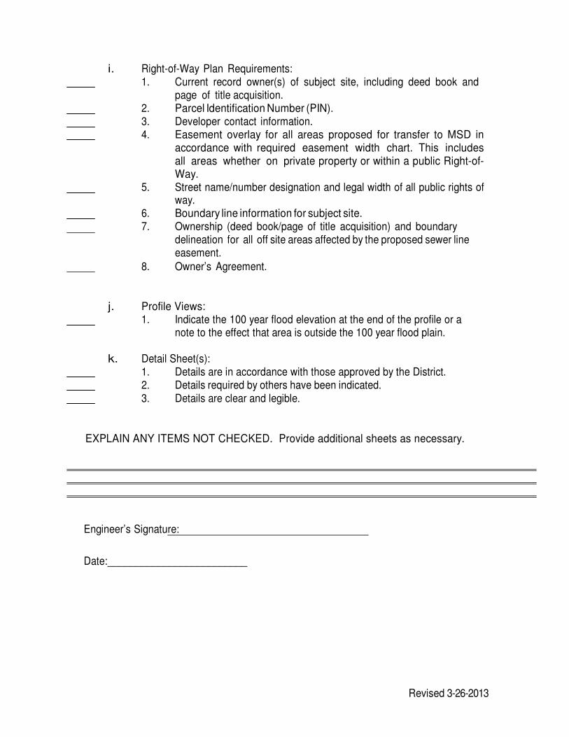
i. Right-of-Way Plan Requirements: 1. Current record owner(s) of subject site, including deed book and
page of title acquisition. 2. Parcel Identification Number (PIN). 3. Developer contact information. 4. Easement overlay for all areas proposed for transfer to MSD in
accordance with required easement width chart. This includes all areas whether on private property or within a public Right-of-Way.
5. Street name/number designation and legal width of all public rights of way.
6. Boundary line information for subject site. 7. Ownership (deed book/page of title acquisition) and boundary
delineation for all off site areas affected by the proposed sewer line easement.
8. Owner’s Agreement.
j. Profile Views: 1. Indicate the 100 year flood elevation at the end of the profile or a
note to the effect that area is outside the 100 year flood plain.
k. Detail Sheet(s): 1. Details are in accordance with those approved by the District. 2. Details required by others have been indicated. 3. Details are clear and legible.
EXPLAIN ANY ITEMS NOT CHECKED. Provide additional sheets as necessary.
Engineer’s Signature:
Date:_________________________
Revised 3-26-2013
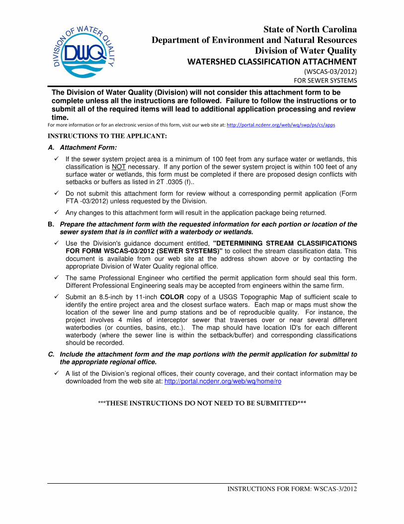
State of North Carolina
Department of Environment and Natural Resources
Division of Water Quality
WATERSHED CLASSIFICATION ATTACHMENT (WSCAS-03/2012)
FOR SEWER SYSTEMS
INSTRUCTIONS FOR FORM: WSCAS-3/2012
The Division of Water Quality (Division) will not consider this attachment form to be complete unless all the instructions are followed. Failure to follow the instructions or to submit all of the required items will lead to additional application processing and review time.
For more information or for an electronic version of this form, visit our web site at: http://portal.ncdenr.org/web/wq/swp/ps/cs/apps
INSTRUCTIONS TO THE APPLICANT:
A. Attachment Form:
� If the sewer system project area is a minimum of 100 feet from any surface water or wetlands, this classification is NOT necessary. If any portion of the sewer system project is within 100 feet of any surface water or wetlands, this form must be completed if there are proposed design conflicts with setbacks or buffers as listed in 2T .0305 (f)..
� Do not submit this attachment form for review without a corresponding permit application (Form FTA -03/2012) unless requested by the Division.
� Any changes to this attachment form will result in the application package being returned.
B. Prepare the attachment form with the requested information for each portion or location of the sewer system that is in conflict with a waterbody or wetlands.
� Use the Division's guidance document entitled, "DETERMINING STREAM CLASSIFICATIONS FOR FORM WSCAS-03/2012 (SEWER SYSTEMS)" to collect the stream classification data. This document is available from our web site at the address shown above or by contacting the appropriate Division of Water Quality regional office.
� The same Professional Engineer who certified the permit application form should seal this form. Different Professional Engineering seals may be accepted from engineers within the same firm.
� Submit an 8.5-inch by 11-inch COLOR copy of a USGS Topographic Map of sufficient scale to identify the entire project area and the closest surface waters. Each map or maps must show the location of the sewer line and pump stations and be of reproducible quality. For instance, the project involves 4 miles of interceptor sewer that traverses over or near several different waterbodies (or counties, basins, etc.). The map should have location ID's for each different waterbody (where the sewer line is within the setback/buffer) and corresponding classifications should be recorded.
C. Include the attachment form and the map portions with the permit application for submittal to the appropriate regional office.
� A list of the Division’s regional offices, their county coverage, and their contact information may be downloaded from the web site at: http://portal.ncdenr.org/web/wq/home/ro
***THESE INSTRUCTIONS DO NOT NEED TO BE SUBMITTED***
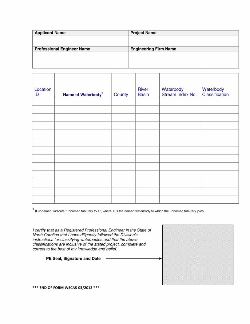
Applicant Name Project Name
Professional Engineer Name Engineering Firm Name
Location ID Name of Waterbody
1 County
River Basin
Waterbody Stream Index No.
Waterbody Classification
1 If unnamed, indicate "unnamed tributary to X", where X is the named waterbody to which the unnamed tributary joins.
I certify that as a Registered Professional Engineer in the State of North Carolina that I have diligently followed the Division's instructions for classifying waterbodies and that the above classifications are inclusive of the stated project, complete and correct to the best of my knowledge and belief.
PE Seal, Signature and Date
*** END OF FORM WSCAS-03/2012 ***

MSD FINAL INSPECTION APPROVAL
(THIS DOCUMENT NOT TO BE USED FOR CERTIFICATE OF OCCUPANCY RELEASE)
PROJECT NAME:
MSD PROJECT NUMBER:
MSD PERMIT NUMBER:
Inspection staff has monitored construction on a periodic basis and has found construction to be in substantial compliance with the standards as set forth by the Metropolitan Sewerage District.
FIELD INSPECTOR
DATE
FORM: IA001

ENGINEER'S CERTIFICATE OF COMPLETION
TO METROPOLITAN SEWERAGE DISTRICT
OF BUNCOMBE COUNTY, NORTH CAROLINA
I, the undersigned, as a duly registered Professional Engineer in the State of North Carolina, having been authorized to observe (weekly, daily, full time) the construction of the project.
, Name of Project Permit # (if applicable)
for (the Applicant, the Permittee), hereby state that, to the best of my abilities, due care and diligence was used in the observation of the construction such that the construction was observed to be built within substantial compliance and intent of the perm it (if applicable), the approved plans and specifications, and other supporting materials (including MSD design criteria).
The (estimated actual) cost of sewer construction for this project was $ .
Signature of Professional Engineer Date
Name of Firm
License Number Seal Revised 3-26-2013
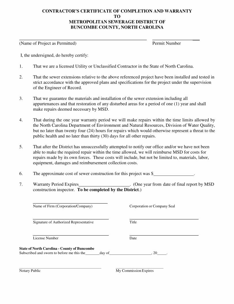
CONTRACTOR’S CERTIFICATE OF COMPLETION AND WARRANTY
TO METROPOLITAN SEWERAGE DISTRICT OF
BUNCOMBE COUNTY, NORTH CAROLINA
(Name of Project as Permitted) Permit Number
I, the undersigned, do hereby certify:
1. That we are a licensed Utility or Unclassified Contractor in the State of North Carolina. 2. That the sewer extensions relative to the above referenced project have been installed and tested in
strict accordance with the approved plans and specifications for the project under the supervision of the Engineer of Record.
3. That we guarantee the materials and installation of the sewer extension including all
appurtenances and that restoration of any disturbed areas for a period of one (1) year and shall make repairs deemed necessary by MSD.
4. That during the one year warranty period we will make repairs within the time limits allowed by
the North Carolina Department of Environment and Natural Resources, Division of Water Quality, but no later than twenty four (24) hours for repairs which would otherwise represent a threat to the public health and no later than thirty (30) days for all other repairs.
5. That after the District has unsuccessfully attempted to notify our office and/or we have not been
able to make the required repair within the time allowed, we will reimburse MSD for costs for repairs made by its own forces. These costs will include, but not be limited to, materials, labor, equipment, damages and reimbursement collection costs.
6. The approximate cost of sewer construction for this project was $ .
7. Warranty Period Expires . (One year from date of final report by MSD
construction inspector. To be completed by the District.)
Name of Firm (Corporation/Company) Corporation or Company Seal
Signature of Authorized Representative Title
License Number Date
State of North Carolina - County of Buncombe Subscribed and sworn to before me this the day of , 20 .
Notary Public My Commission Expires
Y
EASEMENT REQUIREMENTS
1. Off Site Easements
Acquisition of all offsite easements are the sole responsibility of the developer. These easements must be acquired using an Easement Agreement with the current record property owner(s) as “Grantor” and the Developer as “Grantee”. An easement survey plat should be prepared in accordance with “Requirements for Easement Survey Plat” included in this section. Subsequently, these easements will be transferred/assigned/conveyed to the Metropolitan Sewerage District via a Conveyance of Sewer System and Easement Agreement (see sample in this section).
2. Relocation of an Existing MSD Sewer Line
At times, it may become necessary to relocate a portion of the existing MSD sewer system in order to accommodate development of a particular parcel. In these situations, an easement survey plat must be prepared in accordance with easement survey plat requirements and a conveyance document prepared transferring easement rights to the new easement area and ownership of physical elements of the relocated portion of line. You may contact MSD Planning and Development to determine the appropriate form(s) for the site and situation.
NOTE: TRANSFER DOCUMENTS WILL BE REQUIRED PRIOR TO BEGINNING CONSTRUCTION FOR ALL RELOCATION PROJECTS
3. Pump Stations
Pump station easements must be transferred to MSD using the Conveyance of Sewer System and Easement Agreement form example included in this section. The location and dimensions of the required easement areas will be determined on a case by case basis. Pump station easements will require an easement survey with the easement area defined by metes and bounds around the pump station site. Conveyance of an access easement may also be required.
4. Others
For all other projects, easement survey plat requirements may be combined or incorporated into the subdivision plat, the final as-built, or as a separate easement survey as long as all of the required MSD easement survey plat information is shown. Upon review and approval by the District to ensure conformance with MSD easement survey plat requirements, the document may be recorded. A Conveyance of Sewer System and Easement Agreement (sample enclosed) is then prepared with specific reference to the recorded plat.
5. Document Sequence
a) Easement survey plat is prepared in appropriate format b) Easement survey plat is submitted for review by the District as to conformance with plat
requirements c) Easement survey plat is recorded d) Conveyance document is prepared by the Developer’s attorney and submitted to the District for
review prior to recording. Must include a copy of the supporting survey plat for verification of information
e) Conveyance document recorded
NOTE: CERTIFICATE OF OCCUPANCY WILL BE HELD PENDING RECEIPT OF ALL FINAL TRANSFER DOCUMENTS
Revised – March 12, 2009

PREPARED BY AND RETURN AFTER RECORDING TO:
STATE OF NORTH CAROLINA COUNTY OF BUNCOMBE EASEMENT AGREEMENT
THIS EASEMENT AGREEMENT, made this day of , 20 , by and between , hereinafter referred to as Grantor, and
, hereinafter referred to as Grantee (the designations Grantor and Grantee as used herein shall include said parties, their heirs, successors and assigns and shall include singular, plural, masculine, feminine and neuter as required by context).
W I T N E S S E T H:
THAT WHEREAS, the Grantor is the owner of certain property more particularly described in a
Deed recorded in Deed Book at Page , Buncombe County Registry; and
WHEREAS, the Grantee has requested that the Grantor grant and convey to the Grantee a
temporary construction easement and a permanent easement over, upon, across, under and through a portion of the property of the Grantor for purposes of constructing, operating, maintaining, repairing, inspecting and reconstructing sewer lines and accessories and the Grantor has agreed to do so.
NOW, THEREFORE, the Grantor, for and in consideration of the sum of One Dollar ($1.00), and
other good and valuable consideration, the receipt and adequacy of which is hereby acknowledged, has given, granted and conveyed, and by these presents does give, grant, and convey unto the Grantee, its successors and assigns, the temporary and permanent right, privilege and easement to construct, operate, maintain, repair, inspect and reconstruct sanitary sewer lines and accessories over, upon, across, under and through the above-referenced property of the Grantor, said temporary construction easement and permanent easement being described as follows:
PERMANENT EASEMENT: A nonexclusive permanent easement for purposes of constructing,
operating, maintaining, repairing, inspecting and reconstructing sanitary sewer lines, together with such pipes, manholes, fittings, fixtures and other accessories as from time to time may be required, and for purposes of inspecting and performing appropriate tests within said permanent easement, including but not limited to, archaeological and environmental studies, and together with the full right of access to and egress from said permanent easement, said permanent easement being more particularly described as follows:
Legal Description
Said permanent easement consisting of square feet ( acre), more or less.
TEMPORARY CONSTRUCTION EASEMENT: A temporary construction easement for the
purposes of excavation, digging ditches, storing dirt, supplies and materials, moving and using equipment and generally carrying out the completion of the installation of said sanitary sewer lines and accessories, and for the purposes of inspecting and performing appropriate tests within said temporary construction easement, including but not limited to, archaeological and environmental studies, together with the full right of access to and egress from said temporary construction easement for all purposes in connection with said construction and installation, it being understood that this right of use as set out in this paragraph shall terminate upon the final completion of the entire project, said temporary construction easement being more particularly described as follows:

2
Legal Description
Said temporary construction easement consisting of square feet ( acre), more or less.
Said permanent easement and temporary construction easement being shown on the Sewer Line Location Drawing for , Easement Across the Property of , prepared by dated , recorded in Plat Book at Page , Buncombe County Register of Deeds.
IT IS UNDERSTOOD AND AGREED BETWEEN THE GRANTOR AND THE GRANTEE:
1. That the Grantee shall have the right to clear the permanent easement and temporary
construction easement described above and the right but not the obligation to keep the permanent easement clear at all times, and the right to remove from the permanent easement and temporary construction easement all brush, trees and other obstructions, and to go upon said easements whenever necessary for the purpose of clearing the same and removing therefrom all brush, trees and other obstructions of any kind.
2. That the Grantor shall at all times, other than while the sewer lines are under actual
construction, have the right to use said permanent easement and said temporary construction easement, in the same manner as has been heretofore done; provided such use shall in no manner interfere with or be inconsistent with the use thereof by Grantee as provided herein. Prohibited uses of the permanent easement by the Grantor include, but are not limited to, the following: the erection of a shed, building, structure or other obstruction within the permanent easement by the Grantor shall not be allowed; the planting of trees within the permanent easement by the Grantor shall not be allowed; additional fill cannot be placed within the permanent easement except after prior written consent from the Grantee; and other utility lines, including but not limited to, electric, gas, telephone, cable, or water lines, cannot be constructed within the permanent easement except after prior written approval by the Grantee.
3. That the Grantee agrees to restore the topography of said easement area after installation of
the sewer lines and accessories to approximately the same condition as existed before said installation.
4. That the Grantor shall have the right to pass over and upon said permanent easement with
appropriate roadways for the full use of their property, provided, however, that the construction, maintenance and use of said roadways shall in no way interfere with the sewer lines and accessories constructed within said permanent easement. As to paved roads, the Grantee, in future repairs or maintenance of said sewer lines and accessories, shall only be responsible for regraveling, tamping and patching the portion of said paved roads disturbed by such work. As to non-paved roads, the Grantee shall only be responsible for regraveling and tamping in connection with any repairs or maintenance.
5. Other conditions and provisions:
TO HAVE AND TO HOLD said temporary construction easement and said permanent easement
unto said Grantee, its successors and assigns, upon the terms and for the time periods set forth above.
3
The Grantor covenants to and with the Grantee, its successors and assigns, that the Grantor is lawfully seized in fee simple of said lands and premises and has full right and power to convey these easements to the Grantee, and that said lands and premises are free from any and all liens and encumbrances, and that they will and their successors and assigns shall forever warrant and defend the title to said easements unto the Grantee, its successors and assigns, against the lawful claims of all persons whomsoever.
IN WITNESS WHEREOF, the Grantor has hereunto set their hands and seals, or if corporate,
have caused this document to be executed by its duly authorized officers and its seal to be hereunto affixed, as of the day and year first above written.
(SEAL)
(SEAL)
(SEAL)
(SEAL)
By: President
ATTEST:
Secretary (Corporate Seal)
STATE OF NORTH CAROLINA
COUNTY OF BUNCOMBE
I, a Notary Public of the State and County aforesaid, certify that ,
personally appeared before me this day and acknowledged the execution of the foregoing instrument.
WITNESS my hand and official stamp or seal, this day of , 20 .
My Commission Expires: NOTARY PUBLIC
* * * * * * * * * * * *
STATE OF NORTH CAROLINA

4
COUNTY OF BUNCOMBE
I, a Notary Public of the State and County aforesaid, certify that ,
personally appeared before me this day and acknowledged that he is Secretary of , a Corporation, and that by authority duly given and as the act of the corporation, the foregoing instrument was signed in its name by its President, sealed with its corporate seal and attested by h as its Secretary.
WITNESS my hand and official stamp or seal, this day of , 20 .
NOTARY PUBLIC
My Commission Expires:
Easement Agreement -rev. 2000.doc