Embed Size (px)
DESCRIPTION
Chapter 6, Waterbirds, outlines the biological planning approach for waterbirds in the Intermountain West, based on the North American Waterbird Conservation Plan. Like Chapter 5, it includes the most up-to-date information on waterbirds in the Intermountain West including five habitat types, 44 key wetland sites for waterbirds, population status and trends, threats and limiting factors, and population estimates and objectives. It provides a synthesis of several inventory and monitoring studies with monitoring data on select species, and presents profiles of four key species recommended for conservation planning including: White-faced Ibis, American Bittern, Sora, and Greater Sandhill Crane. Lastly, the chapter provides descriptions and threats for six waterbird focal areas including: Southern Oregon and Northeastern California, Great Salt Lake, Bear River Basin, Southeastern Idaho, Upper/Middle Rio Grande Valleys in Colorado and New Mexico, and West-Central Nevada.
Citation preview
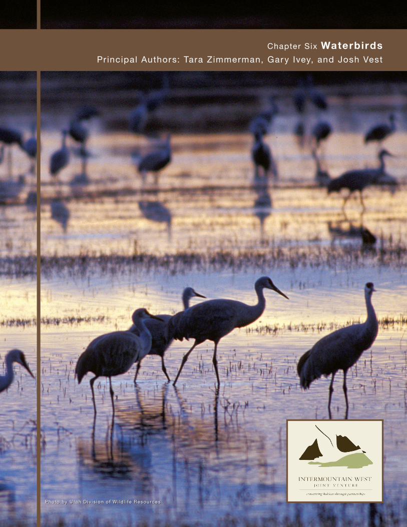
Chapter Six Waterbirds Principal Authors: Tara Zimmerman, Gary Ivey, and Josh Vest
Photo by Utah D iv is ion of Wi ld l i fe Resources
6.2 Intermountain West Joint Venture | C o n s e r v i n g H a b i t a t T h ro u g h P a r t n e r s h i p s | www.iwjv.org
Wa
terb
ird
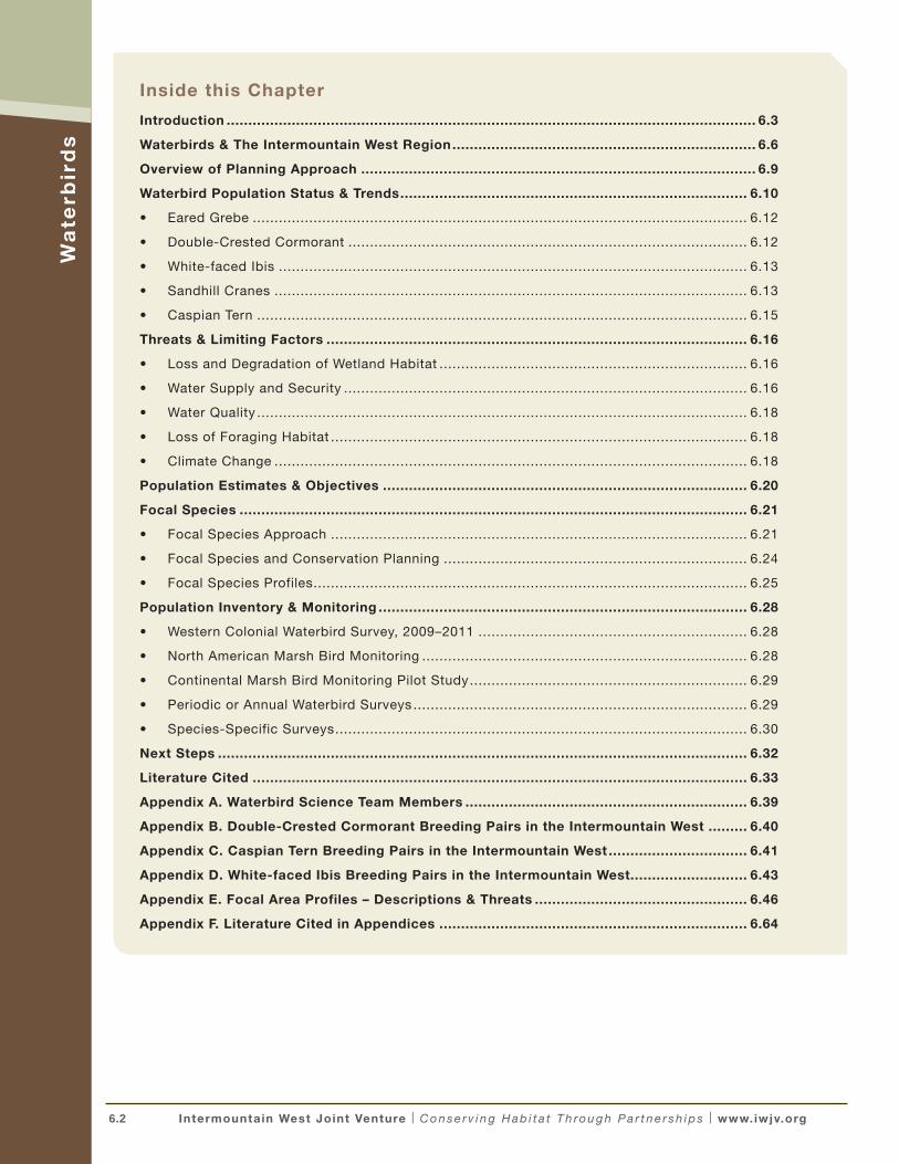
sInside this Chapter
Introduction .......................................................................................................................... 6.3
Waterbirds & The Intermountain West Region ...................................................................... 6.6
Overview of Planning Approach ........................................................................................... 6.9
Waterbird Population Status & Trends ................................................................................ 6.10
• Eared Grebe .................................................................................................................. 6.12
• Double-Crested Cormorant ............................................................................................ 6.12
• White-faced Ibis ............................................................................................................ 6.13
• Sandhill Cranes ............................................................................................................. 6.13
• Caspian Tern ................................................................................................................. 6.15
Threats & Limiting Factors ................................................................................................. 6.16
• Loss and Degradation of Wetland Habitat ....................................................................... 6.16
• Water Supply and Security ............................................................................................. 6.16
• Water Quality ................................................................................................................. 6.18
• Loss of Foraging Habitat ................................................................................................ 6.18
• Climate Change ............................................................................................................. 6.18
Population Estimates & Objectives .................................................................................... 6.20
Focal Species ..................................................................................................................... 6.21
• Focal Species Approach ................................................................................................ 6.21
• Focal Species and Conservation Planning ...................................................................... 6.24
• Focal Species Profiles .................................................................................................... 6.25
Population Inventory & Monitoring ..................................................................................... 6.28
• Western Colonial Waterbird Survey, 2009–2011 .............................................................. 6.28
• North American Marsh Bird Monitoring ........................................................................... 6.28
• Continental Marsh Bird Monitoring Pilot Study ................................................................ 6.29
• Periodic or Annual Waterbird Surveys ............................................................................. 6.29
• Species-Specific Surveys ............................................................................................... 6.30
Next Steps .......................................................................................................................... 6.32
Literature Cited .................................................................................................................. 6.33
Appendix A. Waterbird Science Team Members ................................................................. 6.39
Appendix B. Double-Crested Cormorant Breeding Pairs in the Intermountain West ......... 6.40
Appendix C. Caspian Tern Breeding Pairs in the Intermountain West ................................ 6.41
Appendix D. White-faced Ibis Breeding Pairs in the Intermountain West........................... 6.43
Appendix E. Focal Area Profiles – Descriptions & Threats ................................................. 6.46
Appendix F. Literature Cited in Appendices ....................................................................... 6.64
6.3 Intermountain West Joint Venture | C o n s e r v i n g H a b i t a t T h ro u g h P a r t n e r s h i p s | www.iwjv.org
INTRODUCTION
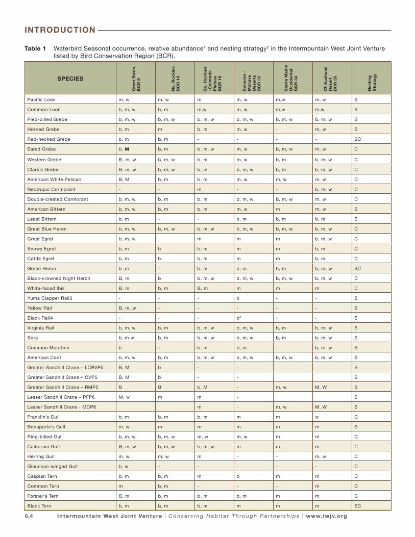
The goal of the Waterbird chapter is to build upon the IWJV 2005 Coordinated Bird Conservation Plan (2005 Implementation Plan) by identifying priority waterbird species within the Intermountain West region and a suite of waterbird focal species from which to develop a regional science-based framework for waterbird conservation. Regional waterbird abundance and distribution data were updated with the most recent and available data which will inform the future derivation of population objectives to support conservation planning. For the purposes of this chapter, waterbirds are defined as wetland dependent colonial, semi-colonial, and solitary nesting species such as loons, grebes, bitterns, herons, egrets, cranes, rails, gulls and terns.
The framework for this chapter is established in continental and regional waterbird conservation plans. Recognizing that conservation is most effective when planned and implemented at the regional and local scales, The North American Waterbird Conservation Plan (NAWCP; Kushlan et. al. 2002) delineated 16 regional waterbird conservation planning areas within North America. The NAWCP also provides conservation assessments, population estimates, and identifies colonial-nesting waterbird species of conservation concern at continental and hemispheric scales. A 2006 supplement to the NAWCP: the Conservation Status Assessment and Categories of Concern for Solitary-Nesting Waterbirds (www.waterbirdconservation.org/assessment.html) assesses and prioritizes the conservation status of 43 species of solitary-nesting waterbirds. The NAWCP and
species assessments provide a common framework to facilitate coordinated waterbird conservation across North America.
The Intermountain West Waterbird Conservation Plan (IWWCP; Ivey and Herziger 2006; http://www.waterbirdconservation.org/intermountain_west.html ) serves as the biological foundation for IWJV waterbird conservation. Thirty-eight species of waterbirds representing nine families regularly utilize the IWJV area as year-round or seasonal habitat (Table 1). The IWWCP plan provides a foundation for biological planning for these waterbirds. It prioritizes breeding and migrant waterbird species at the regional scale; provides data on waterbird distribution and abundance; sets preliminary waterbird population objectives by Bird Conservation Region (BCR) and state; identifies important waterbird habitats in the region; and provides site-specific information on nine key waterbird sites with critical conservation needs. The IWJV encompasses nearly all of the Intermountain West Regional Waterbird Planning Area.
The IWJV’s 2013 Implementation Plan represents an important, incremental step toward strategic conservation planning for waterbirds as it provides the foundation for biological planning. However, actions recommended to conserve important key sites and Bird Habitat Conservation Areas (BHCA) identified in the 2005 Implementation Plan and IWWCP (Ivey and Herziger 2006) will continue to benefit migratory bird populations in the Intermountain West.
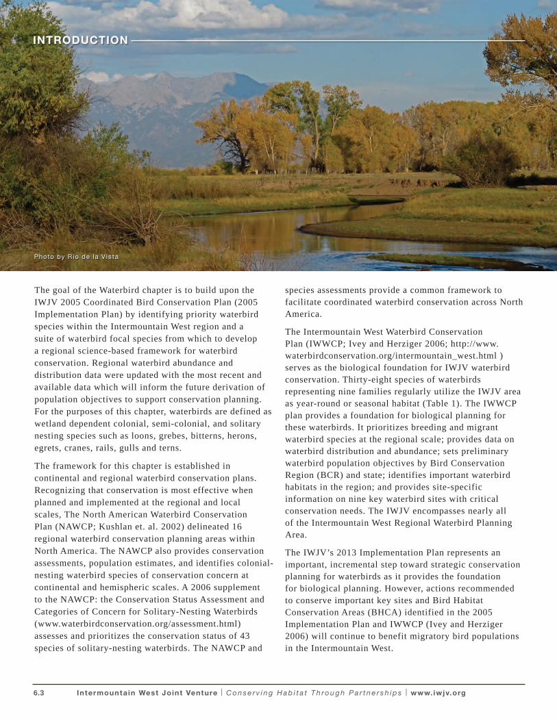
Photo by R io de la V is ta
6.4 Intermountain West Joint Venture | C o n s e r v i n g H a b i t a t T h ro u g h P a r t n e r s h i p s | www.iwjv.org
Table 1 Waterbird Seasonal occurrence, relative abundance1 and nesting strategy2 in the Intermountain West Joint Venture listed by Bird Conservation Region (BCR).
SPECIES
Gre
at
Ba
sin
BC
R 9
No
. R
oc
kie
s B
CR
10
So
. R
oc
kie
s -C
olo
rad
o
Pla
tea
u B
CR
16
So
no
ran
-M
oh
ave
D
ese
rts
BC
R 3
3
Sie
rra
Ma
dre
O
cc
ide
nta
l B
CR
34
Ch
ihu
ah
ua
n D
ese
rt
BC
R 3
5 N
est
ing
S
tra
teg
y
Pacific Loon m, w m, w m m, w m,w m, w S
Common Loon b, m, w b, m m,w m, w m,w m,w S
Pied-billed Grebe b, m, w b, m, w b, m, w b, m, w b, m, w b, m, w S
Horned Grebe b, m m b, m m, w - m, w S
Red-necked Grebe b, m b, m - - - - SC
Eared Grebe b, M b, m b, m, w m, w b, m, w m, w C
Western Grebe B, m, w b, m, w b, m m, w b, m b, m, w C
Clark’s Grebe B, m, w b, m, w b, m b, m, w b, m b, m, w C
American White Pelican B, M b, m b, m m, w m, w m, w C
Neotropic Cormorant - - m - - b, m, w C
Double-crested Cormorant b, m, w b, m b, m b, m, w b, m, w m, w C
American Bittern b, m, w b, m b, m m, w m m, w S
Least Bittern b, m - - b, m b, m b, m S
Great Blue Heron b, m, w b, m, w b, m, w b, m, w b, m, w b, m, w C
Great Egret b, m, w m m m b, m, w C
Snowy Egret b, m b b, m m m b, m C
Cattle Egret b, m b b, m m m b, m C
Green Heron b ,m - b, m b, m b, m b, m, w SC
Black-crowned Night Heron B, m b b, m, w b, m, w b, m, w b, m, w C
White-faced Ibis B, m b, m B, m m m m C
Yuma Clapper Rail3 - - - b - - S
Yellow Rail B, m, w - - - - - S
Black Rail4 - - - b3 - - S
Virginia Rail b, m, w b, m b, m, w b, m, w b, m b, m, w S
Sora b, m w b, m b, m, w b, m, w b, m b, m, w S
Common Moorhen b - b, m b, m - b, m, w S
American Coot b, m, w b, m b, m, w b, m, w b, m, w b, m, w S
Greater Sandhill Crane – LCRVP5 B, M b - - S
Greater Sandhill Crane – CVP5 B, M b - - S
Greater Sandhill Crane – RMP5 B B b, M - m, w M, W S
Lesser Sandhill Crane – PFP6 M, w m m - S
Lesser Sandhill Crane - MCP6 m - m, w M, W S
Franklin’s Gull b, m b, m b, m m m w C
Bonaparte’s Gull m, w m m m m m S
Ring-billed Gull b, m, w b, m, w m, w m, w m m C
California Gull B, m, w b, m, w b, m, w m m m C
Herring Gull m, w m, w m - - m, w C
Glaucous-winged Gull b, w - - - - - C
Caspian Tern b, m b, m m b m m C
Common Tern m b, m - - - m C
Forster’s Tern B, m b, m b, m b, m m m C
Black Tern b, m b, m b, m m m m SC
INTRODUCTION
6.5 Intermountain West Joint Venture | C o n s e r v i n g H a b i t a t T h ro u g h P a r t n e r s h i p s | www.iwjv.org
1. Relative Abundance Indicators: B, M, W – high concentrations, region is extremely important to the species relative to most other regions (Regional BCR AI = 5 or 4 – 25% - 50% of N. American population); B, M, W – common or locally abundant, region is important to the species (Regional BCR AI = 3; with 10% - 24% of N. American population) ; b, m, w – common to fairly uncommon, region is within the species range but species occurs in low abundance relative to other regions (Regional AI = 2 or 1 (<1 – 9% of NA population); b, m, w – status as breeder, migrant, or wintering bird is known but abundance relative to other regions is unknown.
2. Nesting Strategy - Most typical nesting strategy: C= colonial; S= solitary; SC= semi-colonial
3. Yuma Clapper Rail – Occurs in Muddy and Virgin River valleys, NV. Breeding confirmed in Big Marsh, Clark, County NV in 2001 (Floyd 2007).
4. Black Rail – Reported to occur along the Virgin River, Clark County NV in July 2003 but breeding not confirmed (Floyd 2007).
5. Greater Sandhill Crane Population Designations: CVP – Central Valley Population; LCRVP – Lower Colorado River Valley Population; RMP – Rocky Mountain Population; PFP – Pacific Flyway population; MCP – Mid Continent Population.
6. Lesser Sandhill Crane Population Designations: PFP – Pacific Flyway Population; MCP – Mid- continent Population.
INTRODUCTION
6.6 Intermountain West Joint Venture | C o n s e r v i n g H a b i t a t T h ro u g h P a r t n e r s h i p s | www.iwjv.org
WATERBIRDS & THE INTERMOUNTAIN WEST REGION
The IWJV is vast, stretching from Canada to Mexico, and ranging in elevation from 282 feet below sea level to 14,775 feet above sea level. The region is bounded by the Sierra Nevada and Cascades mountains on the west and the Rocky Mountains on the east. With more than 13.4 million acres of aquatic and wetland habitat types, this unique area is characterized by a diverse assemblage of saline ecosystems, freshwater marshes, deep water lakes and reservoirs, agricultural lands, and riparian habitats. Waterbirds occupy the full spectrum of these habitats to meet their requirements for breeding, migrating, and wintering. The IWWCP identifies the following important waterbird habitat types, key sites, and their significance to waterbirds:
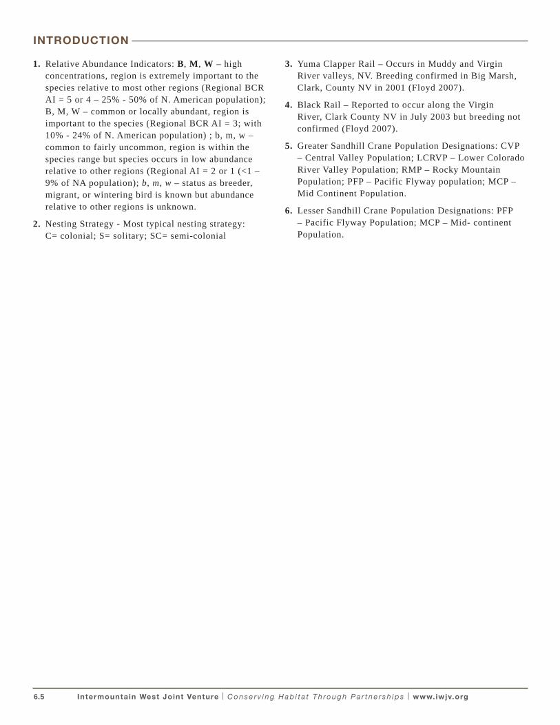
Figure 1 Map of the Intermountain West Joint Venture Area, Bird Conservation Region and State Boundaries.
The IWJV encompasses all or portions of 11 western states, the entire U.S. portions of BCR 9 (Great Basin) and 10 (Northern Rockies), and nearly all of BCR 16 (Southern Rockies; NABCI; Fig. 1). Portions of the Sonoran and Mojave Deserts, Sierra Madre Occidental, Chihuahuan Desert, Pacific Rainforest, Sierra Nevada, and Shortgrass Prairie BCRs are also encompassed by the IWJV. For planning purposes, the latter three BCRs were not addressed because they comprise relatively small portions of the IWJV or because these areas are addressed
in implementation plans developed by other Joint Ventures (i.e., Pacific Coast, Central Valley and Playa Lakes JVs).
Saline LakesThe large, terminal, hyper-saline lakes in the IWJV are renowned for their unique biographic features and significance to wetland-dependant avifauna. Important sites include Mono Lake, California; Great Salt Lake, Utah, and Lake Abert, Harney Lake, and Summer Lake in eastern Oregon (Jehl 1994, Ivey and Herziger 2006). These sites provide an abundance of brine shrimp (Artemia spp.) and brine flies (Ephydra spp.), both critical food resources to various waterbird species during breeding, migration, staging, and molting life-cycle stages. Although the overall number of hyper-saline lakes is small, they support enormous concentrations of waterbirds during key stages of their life cycle. Mono Lake and Great Salt Lake host the largest California Gull rookeries in the world with more than 130,000 breeding adults (Cooper 2004). These two sites alone support millions of Eared Grebes that stage and molt in the fall (Boyd and Jehl 1998; Neill et al. 2009).
Freshwater WetlandsIn contrast to the comparatively few but critical saline lakes, lies an extended network of discrete freshwater marsh habitats dispersed throughout the IWJV landscape. These sites support waterbirds year-round including American White Pelican, Double-crested Cormorant, Greater Sandhill Crane, Sora, American Bittern, Virginia Rail, and numerous species of grebes, herons, egrets, gulls, and terns. Many of these species exhibit site-fidelity, occupying the same locations in multiple years. Yet waterbird colony locations and occupancy can change in response to site-specific and regional habitat conditions that fluctuate with short and long-term flood and drought cycles. Species such as White-faced Ibis have adapted to this variability by developing a nomadic breeding strategy at the landscape scale responding to dramatic shifts in both seasonal and annual wetland habitat conditions (Jehl 1994, Earnst et al. 1998, Haig et al. 1998). Other waterbirds, such as Franklin’s Gulls exhibit a similar strategy, and their colonies are often associated with those of White-faced Ibis. The extended network of semi-permanent wetlands dispersed across the arid west is critical to the reproductive success and long-term population viability of waterbirds throughout the west.
Seasonal wetlands and wet meadows in the region serve as primary breeding and migration habitat for several subspecies and populations of waterbirds of particular management concern. Approximately 90% of
6.7 Intermountain West Joint Venture | C o n s e r v i n g H a b i t a t T h ro u g h P a r t n e r s h i p s | www.iwjv.org
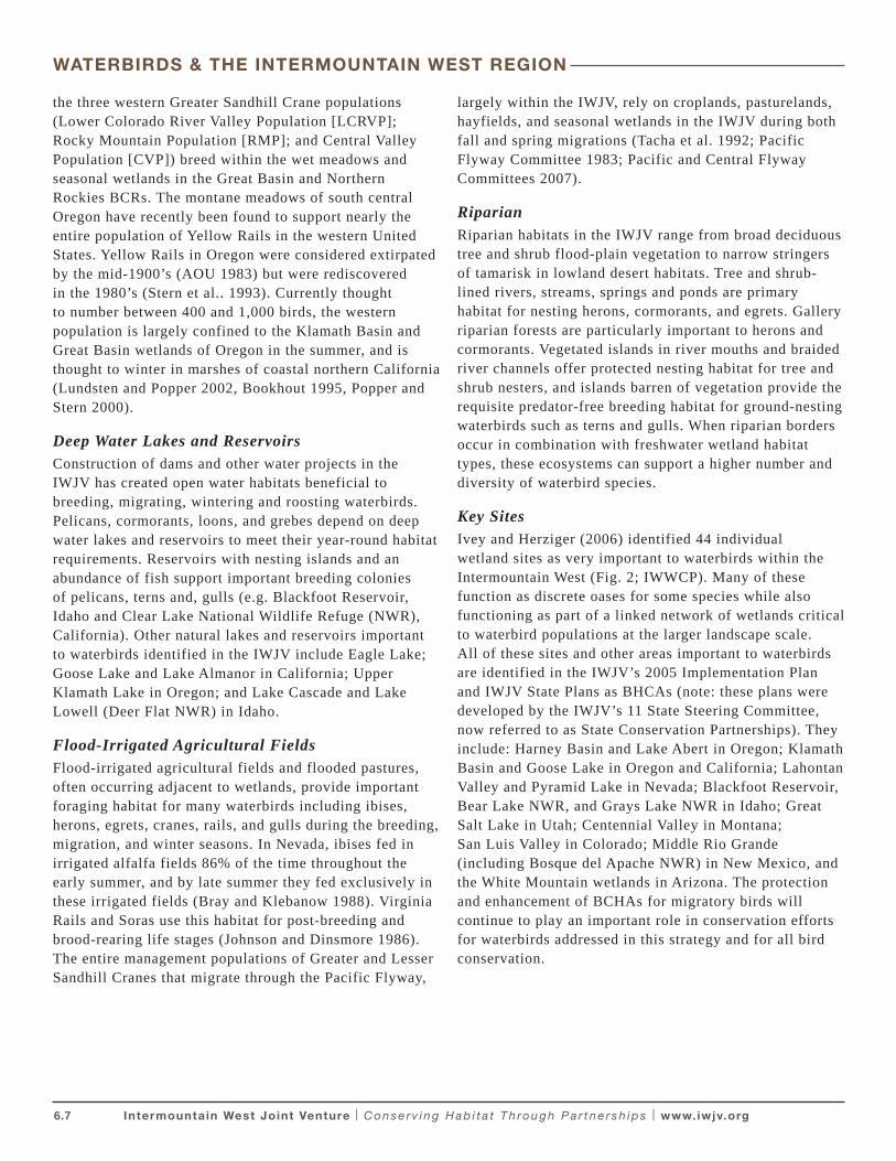
the three western Greater Sandhill Crane populations (Lower Colorado River Valley Population [LCRVP]; Rocky Mountain Population [RMP]; and Central Valley Population [CVP]) breed within the wet meadows and seasonal wetlands in the Great Basin and Northern Rockies BCRs. The montane meadows of south central Oregon have recently been found to support nearly the entire population of Yellow Rails in the western United States. Yellow Rails in Oregon were considered extirpated by the mid-1900’s (AOU 1983) but were rediscovered in the 1980’s (Stern et al.. 1993). Currently thought to number between 400 and 1,000 birds, the western population is largely confined to the Klamath Basin and Great Basin wetlands of Oregon in the summer, and is thought to winter in marshes of coastal northern California (Lundsten and Popper 2002, Bookhout 1995, Popper and Stern 2000).
Deep Water Lakes and ReservoirsConstruction of dams and other water projects in the IWJV has created open water habitats beneficial to breeding, migrating, wintering and roosting waterbirds. Pelicans, cormorants, loons, and grebes depend on deep water lakes and reservoirs to meet their year-round habitat requirements. Reservoirs with nesting islands and an abundance of fish support important breeding colonies of pelicans, terns and, gulls (e.g. Blackfoot Reservoir, Idaho and Clear Lake National Wildlife Refuge (NWR), California). Other natural lakes and reservoirs important to waterbirds identified in the IWJV include Eagle Lake; Goose Lake and Lake Almanor in California; Upper Klamath Lake in Oregon; and Lake Cascade and Lake Lowell (Deer Flat NWR) in Idaho.
Flood-Irrigated Agricultural FieldsFlood-irrigated agricultural fields and flooded pastures, often occurring adjacent to wetlands, provide important foraging habitat for many waterbirds including ibises, herons, egrets, cranes, rails, and gulls during the breeding, migration, and winter seasons. In Nevada, ibises fed in irrigated alfalfa fields 86% of the time throughout the early summer, and by late summer they fed exclusively in these irrigated fields (Bray and Klebanow 1988). Virginia Rails and Soras use this habitat for post-breeding and brood-rearing life stages (Johnson and Dinsmore 1986). The entire management populations of Greater and Lesser Sandhill Cranes that migrate through the Pacific Flyway,
largely within the IWJV, rely on croplands, pasturelands, hayfields, and seasonal wetlands in the IWJV during both fall and spring migrations (Tacha et al. 1992; Pacific Flyway Committee 1983; Pacific and Central Flyway Committees 2007).
RiparianRiparian habitats in the IWJV range from broad deciduous tree and shrub flood-plain vegetation to narrow stringers of tamarisk in lowland desert habitats. Tree and shrub-lined rivers, streams, springs and ponds are primary habitat for nesting herons, cormorants, and egrets. Gallery riparian forests are particularly important to herons and cormorants. Vegetated islands in river mouths and braided river channels offer protected nesting habitat for tree and shrub nesters, and islands barren of vegetation provide the requisite predator-free breeding habitat for ground-nesting waterbirds such as terns and gulls. When riparian borders occur in combination with freshwater wetland habitat types, these ecosystems can support a higher number and diversity of waterbird species.
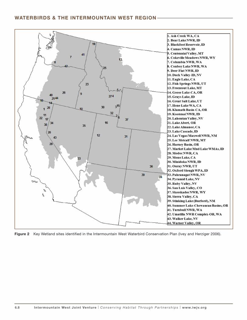
Key SitesIvey and Herziger (2006) identified 44 individual wetland sites as very important to waterbirds within the Intermountain West (Fig. 2; IWWCP). Many of these function as discrete oases for some species while also functioning as part of a linked network of wetlands critical to waterbird populations at the larger landscape scale. All of these sites and other areas important to waterbirds are identified in the IWJV’s 2005 Implementation Plan and IWJV State Plans as BHCAs (note: these plans were developed by the IWJV’s 11 State Steering Committee, now referred to as State Conservation Partnerships). They include: Harney Basin and Lake Abert in Oregon; Klamath Basin and Goose Lake in Oregon and California; Lahontan Valley and Pyramid Lake in Nevada; Blackfoot Reservoir, Bear Lake NWR, and Grays Lake NWR in Idaho; Great Salt Lake in Utah; Centennial Valley in Montana; San Luis Valley in Colorado; Middle Rio Grande (including Bosque del Apache NWR) in New Mexico, and the White Mountain wetlands in Arizona. The protection and enhancement of BCHAs for migratory birds will continue to play an important role in conservation efforts for waterbirds addressed in this strategy and for all bird conservation.
WATERBIRDS & THE INTERMOUNTAIN WEST REGION
6.8 Intermountain West Joint Venture | C o n s e r v i n g H a b i t a t T h ro u g h P a r t n e r s h i p s | www.iwjv.org
Figure 2 Key Wetland sites identified in the Intermountain West Waterbird Conservation Plan (Ivey and Herziger 2006).
WATERBIRDS & THE INTERMOUNTAIN WEST REGION
6.9 Intermountain West Joint Venture | C o n s e r v i n g H a b i t a t T h ro u g h P a r t n e r s h i p s | www.iwjv.org
OVERVIEW OF PLANNING APPROACH
A Waterbird Science Team (WST) comprised of biologists with expertise in waterbird conservation in the Intermountain West convened to develop and guide this Strategy (Appendix A). The WST reviewed priority species, population estimates, population objectives, conservation assessments, and key site conservation strategies identified in the IWWCP and other available sources. When possible, waterbird population estimates and objectives were updated to reflect the current state of information available to support planning. A suite of waterbirds representing IWJV wetland habitat types, nest site attributes, and foraging guilds were identified as Focal Species for future conservation planning purposes. A subset of geographic areas of known significance to focal species, or those with significant concentrations of waterbirds (see Ivey and Herziger 2006) were identified as Focal Areas appropriate for future IWJV waterbird conservation planning at a sub-BCR scale.
State-of-the-art conservation planning incorporates the use of population-habitat models and geospatial data to link population and habitat goals. Ideally, this level of planning would utilize knowledge of the population status and trends, habitat affiliations, limiting factors, and spatial and temporal characteristics of the species and landscape of interest (Will et al. 2005, USFWS 2006). The use of population-habitat modeling and a focal species approach to conservation also requires many assumptions (Caro and O’Doherty 1998, Fleishman et al. 2000, Chase and Guepel 2005). This is particularly true for waterbirds in the Intermountain West because information and data necessary to support biological planning is severely lacking or limited; consequently, our capacity to conduct science-based conservation planning for western waterbirds is similarly challenged. Nonetheless, to initiate the conservation planning process, we identify a subset of focal species and landscapes (Focal Areas) deemed most appropriate for initial IWJV conservation planning for waterbirds. Improvements and advances in population monitoring, wetland inventory, and a better understanding of habitat affiliations, threats, limiting factors, and the spatial and temporal scales of western waterbird populations in the Intermountain West will provide the means to achieve strategic conservation for focal waterbirds in future plan updates.
In consideration of data limitation and the limitations inherent to the use of an umbrella or focal-species approach to landscape scale restoration and protection (see Fleishman et al. 2001, Chase and Guepel 2005, Lindenmayer et al. 2006) the information in this plan is intended to supplement, not replace, the conservation goals and strategies identified in the IWWCP and 2005 IWJV Implementation Plan. The achievement of BHCA goals and wetland habitat acreage objectives at those sites currently documented to support significant waterbird communities (i.e., key sites) will continue to facilitate important habitat enhancement and restoration for waterbirds in the Intermountain West. In this manner, the IWJV will implement a range of approaches to waterbird habitat conservation, while continuing to improve the base of information necessary to advance conservation strategies for waterbirds in future plan updates. As such, this strategy serves as an intermediate step in the development of explicit conservation targets for waterbirds in the Intermountain West.
Photo by Gar y Ivey
6.10 Intermountain West Joint Venture | C o n s e r v i n g H a b i t a t T h ro u g h P a r t n e r s h i p s | www.iwjv.org
Expert opinion and data from local, state, regional and national population monitoring programs were considered and compiled in the species conservation assessment process documented in the regional IWWCP (Ivey and Herziger 2006). For breeding waterbirds, IWWCP species priorities were identified using a modified conservation assessment process based on the Partners in Flight Species Assessment (Panjabi et al. 2005). Migrant waterbirds were identified as high conservation concern in the IWWCP if a site within a BCR supported 10% or more of the North American population during migration or if specific threats were identified at primary staging sites. Of the 33 waterbird species that regularly breed in the IWJV, the regional IWWCP identified six colonial-nesting and four solitary-nesting waterbirds as species of high concern: Western Grebe, Clark’s Grebe, American White Pelican, Snowy Egret, Franklin’s Gull, and Black Tern; and Common Loon, American Bittern, Yellow Rail, and Greater Sandhill Crane (CVP). Migrant or wintering populations of Eared Grebe, Lesser Sandhill Crane, and LCRVP, RMP and CVP migrant Greater Sandhill Crane are also identified as species of high conservation concern at the regional scale.
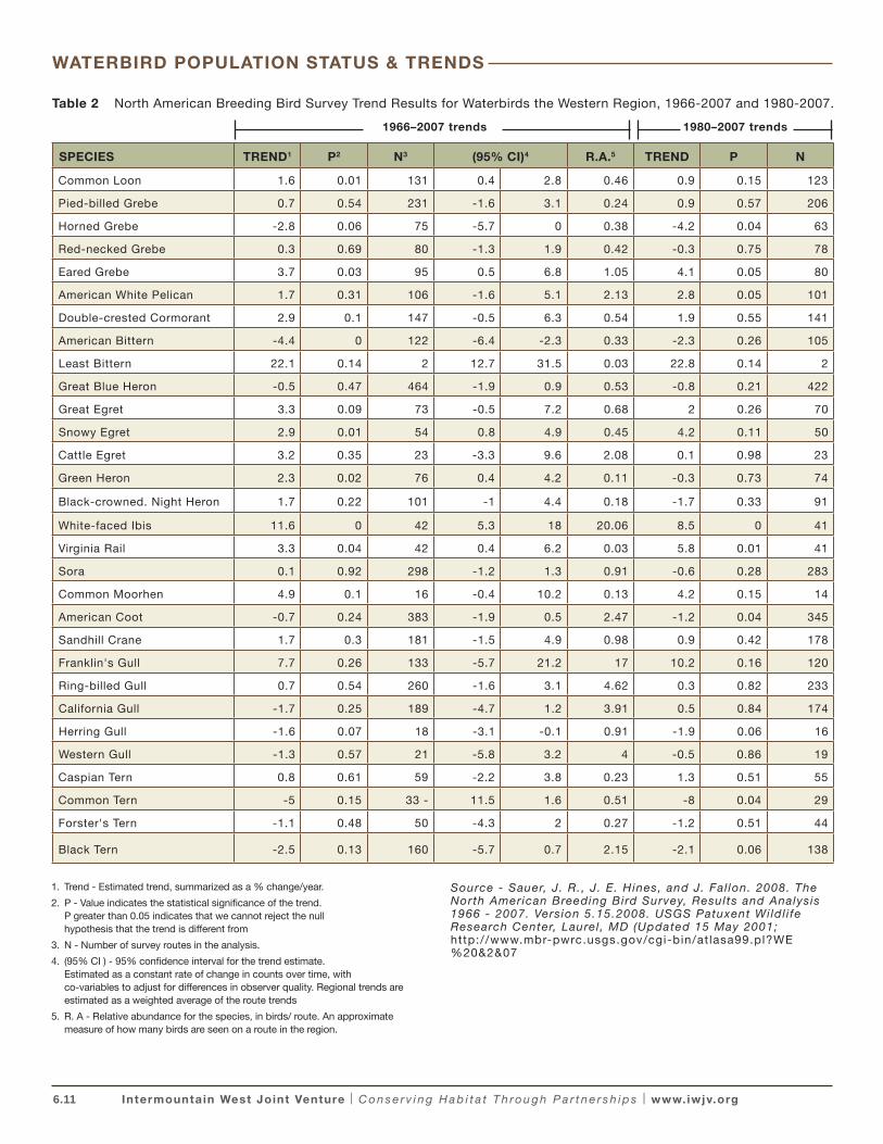
For most waterbirds, data on population sizes over time is unavailable or insufficient for the purpose of estimating population trends. The North American Breeding Bird Survey (BBS) long-term trend results (1966 – 2007) indicate significant increasing population trends (P< .05) for four waterbird species in the Western Region: Common Loon, Eared Grebe, Snowy Egret, and Green Heron (Table 2; Sauer et al. 2008). Because the BBS uses a roadside point-count survey technique, certain habitats and species such as wetlands and colonial waterbirds are under-sampled (Bystrack 1981, Robbins et al. 1986). BBS trend estimates for waterbirds are particularly subject to known BBS data deficiencies including small sample sizes, low relative abundance on survey routes, and imprecise trends (Sauer et al. 2008). Even species with reported significant trends may have data deficiencies that affect the credibility of regional estimates of trend. For example, Western Region BBS data collected during the breeding season indicate that the population of Eared Grebes significantly increased 1966-2007 and 1980-2007 (Table 2); however, standardized species-specific annual monitoring efforts conducted at two saline lakes in the Intermountain West that support 99% of this population during the fall indicate declining population trends for this waterbird (see next page).
WATERBIRD POPULATION STATUS & TRENDS
Photo by Gar y Ivey
6.11 Intermountain West Joint Venture | C o n s e r v i n g H a b i t a t T h ro u g h P a r t n e r s h i p s | www.iwjv.org
Table 2 North American Breeding Bird Survey Trend Results for Waterbirds the Western Region, 1966-2007 and 1980-2007.
SPECIES TREND1 P2 N3 (95% CI)4 R.A.5 TREND P N
Common Loon 1.6 0.01 131 0.4 2.8 0.46 0.9 0.15 123
Pied-billed Grebe 0.7 0.54 231 -1.6 3.1 0.24 0.9 0.57 206
Horned Grebe -2.8 0.06 75 -5.7 0 0.38 -4.2 0.04 63
Red-necked Grebe 0.3 0.69 80 -1.3 1.9 0.42 -0.3 0.75 78
Eared Grebe 3.7 0.03 95 0.5 6.8 1.05 4.1 0.05 80
American White Pelican 1.7 0.31 106 -1.6 5.1 2.13 2.8 0.05 101
Double-crested Cormorant 2.9 0.1 147 -0.5 6.3 0.54 1.9 0.55 141
American Bittern -4.4 0 122 -6.4 -2.3 0.33 -2.3 0.26 105
Least Bittern 22.1 0.14 2 12.7 31.5 0.03 22.8 0.14 2
Great Blue Heron -0.5 0.47 464 -1.9 0.9 0.53 -0.8 0.21 422
Great Egret 3.3 0.09 73 -0.5 7.2 0.68 2 0.26 70
Snowy Egret 2.9 0.01 54 0.8 4.9 0.45 4.2 0.11 50
Cattle Egret 3.2 0.35 23 -3.3 9.6 2.08 0.1 0.98 23
Green Heron 2.3 0.02 76 0.4 4.2 0.11 -0.3 0.73 74
Black-crowned. Night Heron 1.7 0.22 101 -1 4.4 0.18 -1.7 0.33 91
White-faced Ibis 11.6 0 42 5.3 18 20.06 8.5 0 41
Virginia Rail 3.3 0.04 42 0.4 6.2 0.03 5.8 0.01 41
Sora 0.1 0.92 298 -1.2 1.3 0.91 -0.6 0.28 283
Common Moorhen 4.9 0.1 16 -0.4 10.2 0.13 4.2 0.15 14
American Coot -0.7 0.24 383 -1.9 0.5 2.47 -1.2 0.04 345
Sandhill Crane 1.7 0.3 181 -1.5 4.9 0.98 0.9 0.42 178
Franklin's Gull 7.7 0.26 133 -5.7 21.2 17 10.2 0.16 120
Ring-billed Gull 0.7 0.54 260 -1.6 3.1 4.62 0.3 0.82 233
California Gull -1.7 0.25 189 -4.7 1.2 3.91 0.5 0.84 174
Herring Gull -1.6 0.07 18 -3.1 -0.1 0.91 -1.9 0.06 16
Western Gull -1.3 0.57 21 -5.8 3.2 4 -0.5 0.86 19
Caspian Tern 0.8 0.61 59 -2.2 3.8 0.23 1.3 0.51 55
Common Tern -5 0.15 33 - 11.5 1.6 0.51 -8 0.04 29
Forster's Tern -1.1 0.48 50 -4.3 2 0.27 -1.2 0.51 44
Black Tern -2.5 0.13 160 -5.7 0.7 2.15 -2.1 0.06 138
1966–2007 trends 1980–2007 trends
1. Trend - Estimated trend, summarized as a % change/year.
2. P - Value indicates the statistical significance of the trend. P greater than 0.05 indicates that we cannot reject the null hypothesis that the trend is different from
3. N - Number of survey routes in the analysis.
4. (95% CI ) - 95% confidence interval for the trend estimate. Estimated as a constant rate of change in counts over time, with co-variables to adjust for differences in observer quality. Regional trends are estimated as a weighted average of the route trends
5. R. A - Relative abundance for the species, in birds/ route. An approximate measure of how many birds are seen on a route in the region.
Source - Sauer, J. R. , J. E. Hines, and J. Fal lon. 2008. The North American Breeding Bird Survey, Results and Analysis 1966 - 2007. Version 5.15.2008. USGS Patuxent Wi ldl i fe Research Center, Laurel , MD (Updated 15 May 2001; http://www.mbr-pwrc.usgs.gov/cgi-bin/at lasa99.pl?WE %20&2&07
WATERBIRD POPULATION STATUS & TRENDS
6.12 Intermountain West Joint Venture | C o n s e r v i n g H a b i t a t T h ro u g h P a r t n e r s h i p s | www.iwjv.org
With few exceptions, trend estimates for waterbirds in the NAWCP and IWWCP necessarily relied on expert opinion and both published and unpublished literature. The majority of IWWCP population trend (PT) scores for waterbirds listed by BCRs and states were assigned as “unknown” or “historically declined and apparently recovered” (PT = 3). Population size and trend estimates are most notably lacking for bitterns, rails and other secretive marsh birds but even the more common and widespread colonial waterbirds such as Great Blue Heron and Black-crowned Night Heron lack reliable trend estimates for the western U.S., the IWJV region, and most states.
Population trends are known for a few waterbird species of particular management concern. Standardized annual monitoring programs, periodic rangewide surveys, and comprehensive status reviews provide insight into population trends of RMP and LCRV Sandhill Cranes, Eared Grebes, Caspian Terns and Double-crested Cormorants:
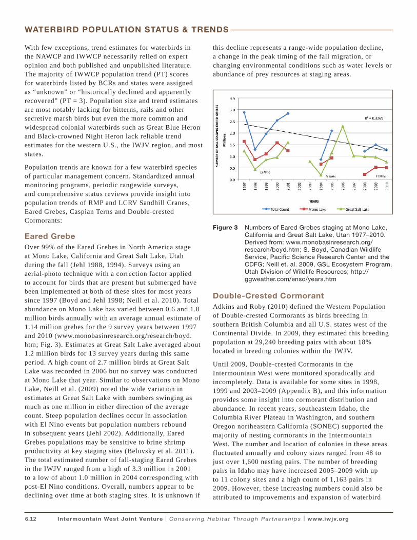
Eared GrebeOver 99% of the Eared Grebes in North America stage at Mono Lake, California and Great Salt Lake, Utah during the fall (Jehl 1988, 1994). Surveys using an aerial-photo technique with a correction factor applied to account for birds that are present but submerged have been implemented at both of these sites for most years since 1997 (Boyd and Jehl 1998; Neill et al. 2010). Total abundance on Mono Lake has varied between 0.6 and 1.8 million birds annually with an average annual estimate of 1.14 million grebes for the 9 survey years between 1997 and 2010 (www.monobasinresearch.org/research/boyd.htm; Fig. 3). Estimates at Great Salt Lake averaged about 1.2 million birds for 13 survey years during this same period. A high count of 2.7 million birds at Great Salt Lake was recorded in 2006 but no survey was conducted at Mono Lake that year. Similar to observations on Mono Lake, Neill et al. (2009) noted the wide variation in estimates at Great Salt Lake with numbers swinging as much as one million in either direction of the average count. Steep population declines occur in association with El Nino events but population numbers rebound in subsequent years (Jehl 2002). Additionally, Eared Grebes populations may be sensitive to brine shrimp productivity at key staging sites (Belovsky et al. 2011). The total estimated number of fall-staging Eared Grebes in the IWJV ranged from a high of 3.3 million in 2001 to a low of about 1.0 million in 2004 corresponding with post-El Nino conditions. Overall, numbers appear to be declining over time at both staging sites. It is unknown if
this decline represents a range-wide population decline, a change in the peak timing of the fall migration, or changing environmental conditions such as water levels or abundance of prey resources at staging areas.
Figure 3 Numbers of Eared Grebes staging at Mono Lake, California and Great Salt Lake, Utah 1977–2010. Derived from: www.monobasinresearch.org/research/boyd.htm; S. Boyd, Canadian Wildlife Service, Pacific Science Research Center and the CDFG; Neill et. al. 2009, GSL Ecosystem Program, Utah Division of Wildlife Resources; http://ggweather.com/enso/years.htm
Double-Crested CormorantAdkins and Roby (2010) defined the Western Population of Double-crested Cormorants as birds breeding in southern British Columbia and all U.S. states west of the Continental Divide. In 2009, they estimated this breeding population at 29,240 breeding pairs with about 18% located in breeding colonies within the IWJV.
Until 2009, Double-crested Cormorants in the Intermountain West were monitored sporadically and incompletely. Data is available for some sites in 1998, 1999 and 2003–2009 (Appendix B), and this information provides some insight into cormorant distribution and abundance. In recent years, southeastern Idaho, the Columbia River Plateau in Washington, and southern Oregon northeastern California (SONEC) supported the majority of nesting cormorants in the Intermountain West. The number and location of colonies in these areas fluctuated annually and colony sizes ranged from 48 to just over 1,600 nesting pairs. The number of breeding pairs in Idaho may have increased 2005–2009 with up to 11 colony sites and a high count of 1,163 pairs in 2009. However, these increasing numbers could also be attributed to improvements and expansion of waterbird
WATERBIRD POPULATION STATUS & TRENDS
6.13 Intermountain West Joint Venture | C o n s e r v i n g H a b i t a t T h ro u g h P a r t n e r s h i p s | www.iwjv.org
monitoring in Idaho implemented 2005–2009 (see Moulton 2005–2009). During this same period, numbers of breeding cormorants in the Columbia Plateau of Washington remained relatively stable, fluctuating from a high of 1,554 in 2006 at five colony sites to a low of 1,196 in 2009 at four colony sites (Roby and Adkins 2010). In the SONEC area, the Upper Klamath Marsh, Lower Klamath NWR, Tule Lake NWR and Clear Lake NWR support most of the cormorants that breed in this region. Recent drought conditions in the Klamath Basin eliminated nesting islands and reduced foraging habitat at many known colony sites; thus, population levels in 2009 were lower than in most years (Shuford and Henderson 2010). The peak Double-Crested Cormorant count in the Klamath Basin occurred in 2003 when 1,603 breeding pairs were estimated (Shuford and Henderson 2010). In Nevada numbers of cormorants have declined from 1,677 pairs at 4 colony sites in 1999 to 660 breeding pairs at 6 colony sites in 2009 (Adkins and Roby 2010).
In total, about 60 sites scattered across the IWJV have been colonized by cormorants but many are occupied infrequently. Double-crested Cormorants in the Intermountain West are subject to the effects of drought, recurrent flooding and stranding of colonies, and loss of foraging habitat due to agricultural withdrawals and runoff for irrigation purposes. These conditions likely limit the population growth of Double-crested Cormorants in the IWJV area.
White-faced IbisBetween the 1960s and 1970s the numbers of White-faced Ibises breeding in the Great Basin Region declined significantly (King et al. 1980; Steele 1980), presumably, from exposure to DDT on their wintering grounds in the interior of Mexico (Capen 1977, Henny 1997). Between 1985–1997, the Great Basin population rebounded and the number of breeding ibises nearly tripled from an estimated 7,500 pairs among 19 colonies in the mid-1980s to about 30,000 pairs at 40 sites in the late 1990s (Earnst et. al. 1998). Breeding distribution shifted radically over time in response to seasonal environmental conditions such as flood and drought (Earnst et al. 1998). In 1979-1980, the majority of ibises in the Intermountain West were breeding at Great Salt Lake; however, when marshes of the Great Salt Lake were flooded 1983–1989 ibis colony sites were submerged and ibis numbers there decreased approximatley 80%; (Jehl 1994). Concomitantly, numbers of breeding ibises increased at Malheur and Summer Lakes, Oregon as did colony sizes at the Stillwater and Carson Lakes areas of Nevada (Ivey et al. 1988, Jehl 1994). When drought conditions dried these areas 1987–
1992, nesting colonies failed but successful ibis colonies were re-established at Great Salt Lake (Ivey et al. 1988, Jehl 1994, Earnst 1998).
Surveys conducted in 2009 and 2010 again documented significant population growth and redistribution of breeding White-faced Ibises in the IWJV compared to previous decades (Appendix C). All states in the IWJV region surveyed ibises as part of the Western Colonial Waterbird Survey (WCWS) in 2010 (USFWS 2011) with the exception of Utah where ibis colonies were surveyed in 2009. Preliminary results from these surveys documented about 67,000 pairs of ibises in 2010 and 23,600 pairs in Utah in 2009 for a combined total of about 90,600 pairs at 47 colony sites for the 2 year survey period (Appendix C). This is triple the number of breeding White-faced Ibises documented in the late 1990s. The core of the population now breeds in southeastern Idaho, followed by smaller numbers in SONEC (Lower Klamath NWR, California; Malheur NWR, and Goose Lake, Oregon) and the Great Salt Lake. The six active colonies in Idaho supported 44,250 nesting pairs representing nearly half of the total Intermountain West population of breeding ibises for the combined 2009-2010 survey period. When numbers of breeding ibises in southeastern Idaho are combined with those breeding at Bear River Migratory Bird Refuge, Utah and Cokeville Meadows, Wyoming (in the Bear River Basin) and Great Salt Lake, Utah, this tri-state region currently supports 65.3% of the total number of breeding ibises in the Intermountain West. Reasons for this recent redistribution are unclear but are likely related to drought conditions and forage availability at traditional colony sites. A landscape-scale analysis of ibis breeding and foraging habitat in current and historic key locations for this species (i.e. Southeast Idaho, SONEC, and Great Salt Lake and Lahontan Valley) will aid in informing conservation for this species.
Sandhill CranesThe Pacific Flyway Council established management plans for the RMP, CVP and LCRV populations of Greater Sandhill Cranes (1995, 1997 and 2007) and also for the Pacific Flyway Population (PFP) of Lesser Sandhill Cranes (Pacific Flyway Council 1983). These plans established population objectives and multi-state cooperative monitoring programs that have been implemented annually since 1992 for RMP and 1998 for LCRV. Standardized monitoring programs have not been implemented for the CVP or PFP.
The highest nesting concentrations of RMP Greater Sandhill Cranes occur in western Montana and Wyoming, eastern Idaho, northern Utah, and northwestern Colorado
WATERBIRD POPULATION STATUS & TRENDS
6.14 Intermountain West Joint Venture | C o n s e r v i n g H a b i t a t T h ro u g h P a r t n e r s h i p s | www.iwjv.org
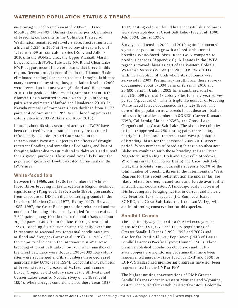
(Kruse 2011). The major spring and fall migration staging area for the RMP is the San Luis Valley Colorado, where virtually the entire population spends 3–4 months annually (Drewien and Bizeau 1974, Kauffeld 1982). Several important overnight stopovers are used by RMP cranes during spring and fall migration including Harts Basin and the Grand Valley, Colorado, and the Green River near Jensen to Ouray National Wildlife Refuge in Utah (Drewien and Bizeau 1974, Peterson and Drewien 1997) and Cochiti and Jemez reservoirs, New Mexico (Stahlecker 1992). Other important fall staging sites include the Teton Basin, Grays Lake, in Idaho, Eden Valley in Wyoming, and the Bear River Valley in Idaho, Utah and Wyoming (Drewien and Bizeau 1974, R. Drewien, pers. comm.). The 2010 standardized fall pre-migration count documented 21,064 RMP cranes with a 3-year average of 20,847 (Fig. 4). This is within the population objective established by the flyways of 17,000–21,000 for the RMP (Kruse 2011). Their principal wintering area is the Middle Rio Grande Valley, New Mexico. Smaller numbers winter in northeastern and southwestern New Mexico, southeastern Arizona, and the northern highlands of Mexico (Drewien and Bizeau 1974, Perkins and Brown 1981, Drewien et al. 1996). On winter areas, RMP cranes mix with the Mid-continent Population (MCP), and cannot be managed separately from them.
Figure 4 Fall pre-migration abundance indices for the Rocky Mountain population of Sandhill Cranes. Derived from Kruse et al. (2011).
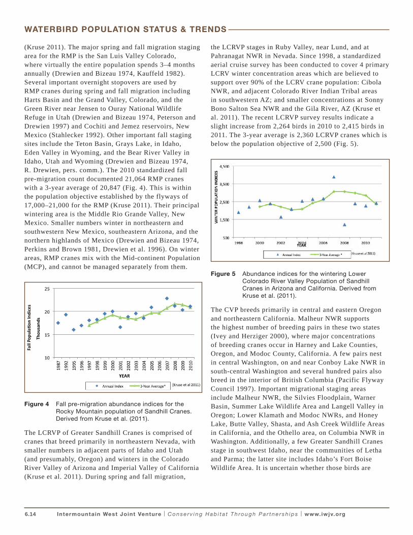
The LCRVP of Greater Sandhill Cranes is comprised of cranes that breed primarily in northeastern Nevada, with smaller numbers in adjacent parts of Idaho and Utah (and presumably, Oregon) and winters in the Colorado River Valley of Arizona and Imperial Valley of California (Kruse et al. 2011). During spring and fall migration,
the LCRVP stages in Ruby Valley, near Lund, and at Pahranagat NWR in Nevada. Since 1998, a standardized aerial cruise survey has been conducted to cover 4 primary LCRV winter concentration areas which are believed to support over 90% of the LCRV crane population: Cibola NWR, and adjacent Colorado River Indian Tribal areas in southwestern AZ; and smaller concentrations at Sonny Bono Salton Sea NWR and the Gila River, AZ (Kruse et al. 2011). The recent LCRVP survey results indicate a slight increase from 2,264 birds in 2010 to 2,415 birds in 2011. The 3-year average is 2,360 LCRVP cranes which is below the population objective of 2,500 (Fig. 5).
Figure 5 Abundance indices for the wintering Lower Colorado River Valley Population of Sandhill Cranes in Arizona and California. Derived from Kruse et al. (2011).
The CVP breeds primarily in central and eastern Oregon and northeastern California. Malheur NWR supports the highest number of breeding pairs in these two states (Ivey and Herziger 2000), where major concentrations of breeding cranes occur in Harney and Lake Counties, Oregon, and Modoc County, California. A few pairs nest in central Washington, on and near Conboy Lake NWR in south-central Washington and several hundred pairs also breed in the interior of British Columbia (Pacific Flyway Council 1997). Important migrational staging areas include Malheur NWR, the Silvies Floodplain, Warner Basin, Summer Lake Wildlife Area and Langell Valley in Oregon; Lower Klamath and Modoc NWRs, and Honey Lake, Butte Valley, Shasta, and Ash Creek Wildlife Areas in California, and the Othello area, on Columbia NWR in Washington. Additionally, a few Greater Sandhill Cranes stage in southwest Idaho, near the communities of Letha and Parma; the latter site includes Idaho’s Fort Boise Wildlife Area. It is uncertain whether those birds are
WATERBIRD POPULATION STATUS & TRENDS
6.15 Intermountain West Joint Venture | C o n s e r v i n g H a b i t a t T h ro u g h P a r t n e r s h i p s | www.iwjv.org
from the CVP or the LCRVP. They share these sites with migrating PFP Lesser Sandhill Cranes.
The PFP of Lesser Sandhill Cranes numbers more than 30,000 birds that breed in south-central and south-west Alaska and migrates through the IWJV via California, Idaho, Oregon, and Washington during spring and fall. The most important staging site is located on Columbia NWR at Othello, Washington, where more than 90% of the population stops during spring migration. Important Oregon sites include the Silvies Floodplain in Harney County, Summer Lake Wildlife Area, and the Chewaucan, Goose Lake and Warner Basins. Major staging sites in California include Modoc NWR vicinity, Surprise Valley, and Lower Klamath NWR. PFP cranes winter outside of the IWJV, in the Central Valley of California, primarily in the Sacramento-San Joaquin Delta and the San Joaquin Valley near the cities of Modesto, Merced, and Pixley.
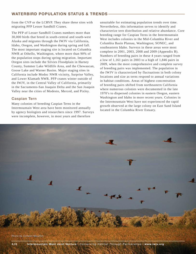
Caspian TernMany colonies of breeding Caspian Terns in the Intermountain West area have been monitored annually by agency biologists and researchers since 1997. Surveys were incomplete, however, in most years and therefore
unsuitable for estimating population trends over time. Nevertheless, this information serves to identify and characterize tern distribution and relative abundance. Core breeding range for Caspian Terns in the Intermountain West includes colonies in the Mid-Columbia River and Columbia Basin Plateau, Washington; SONEC, and southeastern Idaho. Surveys in these areas were most complete in 2001, 2003, 2008 and 2009 (Appendix B). Numbers of breeding pairs in these 4 years ranged from a low of 1,161 pairs in 2003 to a high of 1,846 pairs in 2009, when the most comprehensive and complete survey of breeding pairs was implemented. The population in the IWJV is characterized by fluctuations in both colony locations and size as terns respond to annual variations in habitat conditions. Areas of highest concentration of breeding pairs shifted from northeastern California where numerous colonies were documented in the late 1970’s to dispersed colonies in eastern Oregon, eastern Washington and Idaho in more recent years. Colonies in the Intermountain West have not experienced the rapid growth observed at the large colony on East Sand Island located in the Columbia River Estuary.
Photo by Co l leen Moul ton
WATERBIRD POPULATION STATUS & TRENDS
6.16 Intermountain West Joint Venture | C o n s e r v i n g H a b i t a t T h ro u g h P a r t n e r s h i p s | www.iwjv.org
Primary Threats to Waterbirds in the Intermountain West Region
• Wetland Habitat Loss
• Loss of water or modified flow regimes
• Water Quality and Contaminants
• Exotic Plant and Fish Species
• Human Disturbance
• Conflicts with other species (Ivey and Herziger, 2006)
Ivey and Herziger (2006) identified and reviewed primary threats and limiting factors for waterbird populations in the Intermountain West. Of greatest conservation concern are issues associated with wetland loss, declining water supply/delivery to wetland habitats, and poor water quality. In recent years, the effects of climate change on migratory birds have been a topic of increasing concern. Quantifying the effects of various anthropogenic and natural threats on waterbird populations is difficult; but, these threats cumulatively or individually can negatively impact waterbird abundance, distribution, and reproductive success at the site specific, regional, or range wide scale. Threats may also vary by individual species and these have been described and characterized for several waterbirds in the West including Double-crested Cormorants (Adkins and Roby 2010), Caspian Terns (Shuford and Craig 2002), and Black Terns (Shuford 1999). Below we summarize broad-scale threats to waterbirds: wetland loss; wetland water supply and security; water quality; and climate change. Region-specific summaries of threats for five waterbird Focal Areas are presented in Appendix D.
Loss and Degradation of Wetland HabitatThe IWWCP identifies one of the most important issues facing waterbird conservation in the Intermountain West as wetland loss. Between the time of initial European settlement and the mid-1980s, more than 50% of freshwater wetlands were lost in the states of Idaho, Nevada, and Colorado and 91% in California, though mostly in the Central Valley (Dahl 1990). Although the rate of wetland loss has slowed over time, the loss of freshwater emergent marsh habitat has continued (Dahl 2006).
Ratti and Kadlec (1992) estimated that approximately 57% of wetlands in the Intermountain West had been lost to drainage associated with agriculture and development. Wetlands now cover only about 1% of the regions land area compared to 5% nationwide (Dahl 2006). The remaining wetlands are critical to waterbird populations at local, regional, and continental scales. Wetlands of the Great Basin support 38% of North America’s waterbird diversity (waterbirds, shorebirds, and waterfowl; Haig et al. 1998) and nearly the entire North American populations of breeding White-face Ibises, California Gulls, and migrant Eared Grebes (Jehl 2004; Engilis and Reid 1996). The Klamath, Harney, Lahontan, and Great Salt Lake Basins are of continental or regional significance to waterbirds such as pelicans, ibises, grebes and gulls (Shuford 2006; Shuford and Henderson 2010; G. Ivey, unpublished data). Wetlands in southeastern Idaho are emerging as an increasingly significant component of the network of Intermountain West sites that support breeding White-faced Ibises and Franklin’s Gulls (Moulton 2006, 2007). Unfortunately, information to assess the amount, distribution and quality of wetland habitats in most of the Intermountain West is inadequate or unavailable at this time (refer to Chapter 2 of the IWJV 2013 Implementation Plan). Updated USFWS National Wetlands Inventory (NWI) data is a critical need throughout the western United States. The lack of this baseline habitat data and paucity of standardized population monitoring for waterbirds continues to impede progress and effectiveness of waterbird conservation efforts in the West.
Water Supply and SecurityHistoric and contemporary policies pertaining to the protection and use of water in the arid West prioritize agriculture and municipal uses over environmental uses such as wetland management for migratory birds (Downard 2010). In 1990, about 80% of the water diverted from streams in the western United States was used for agricultural purposes (Solly 1997). In 2005, the states of California, Idaho, Colorado and Montana combined accounted for 64% of all surface water withdrawals for irrigation nationwide (Kenny et al. 2009). These diversions and withdrawals, primarily from snow-melt dependant streams, can leave natural and managed wetlands dry mid-summer through fall when waterbirds require wetlands for breeding, fledging, post-breeding, and foraging, particularly in years experiencing drought conditions. Wetland complexes critical to western waterbird populations such as Mono Lake, California, Great Salt Lake, Utah, Lahontan Valley, Nevada and Klamath Basin, Oregon have all been subject to
THREATS & LIMITING FACTORS
6.17 Intermountain West Joint Venture | C o n s e r v i n g H a b i t a t T h ro u g h P a r t n e r s h i p s | www.iwjv.org
significant declines in water supply due to diversions and withdrawals from inflow streams and tributaries, primarily for agricultural purposes (Jehl 1994, Ivey 2001, Downard 2010, Mono Lake Committee 2011).
Increasing competition for water supplies stemming from population growth in the Intermountain West is further taxing already limited water resources in the arid region. Between 2000 and 2010 the human population increased 21% in Idaho, 23% in Utah and 35% in Nevada (U.S. Census Bureau 2011). With population growth the demands for water for urban, municipal, and industrial uses escalate. Although surface runoff can account for up to 80% of lake and wetland recharge among the terminal lakes and wetlands in the Great Basin (Hoffman 1994), many wetland complexes in the Intermountain West are equally impacted by groundwater recharge (Engilis and Reid 1996). Ground water withdrawals to support growing urban and suburban communities in the west can also pose threats to wetlands, as recently documented at Great Salt Lake (Bishop et al. 2009, Yidana et al. 2010).
Wetland protection provided by federal legislation such as Section 404 of the Clean Water Act, public ownership of wetlands (e.g. NWRs and WMAs), and restoration programs such as the Wetlands Reserve Program may protect or restore wetland habitat, but these mechanisms do not always protect water supplies or ensure water security to wetlands managed for migratory birds. Downard (2010) defined water security “the availability of a quantity of water, during most years, sufficient to support enough flooded or periodically flooded wetlands to meet habitat needs established by each refuge”. The lack of water security combined with the scarcity and annual variability of water in Intermountain West represent a substantial and ongoing threat to waterbirds in the region. Increasing demands for water from population growth, urban expansion, and power generation will further exacerbate future competition for water in the arid West.
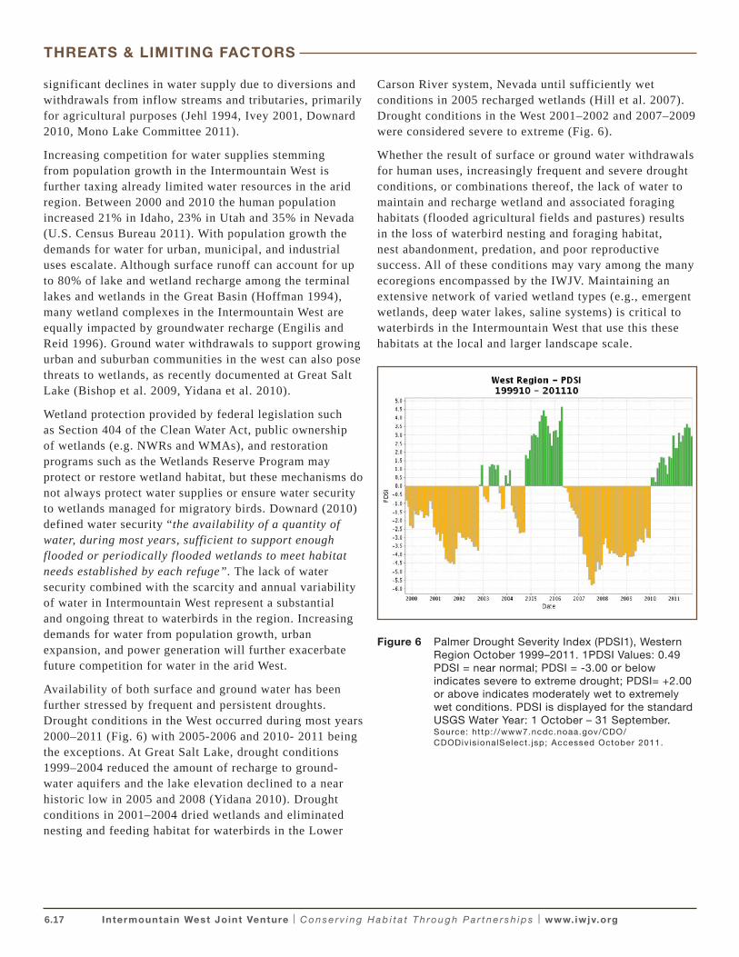
Availability of both surface and ground water has been further stressed by frequent and persistent droughts. Drought conditions in the West occurred during most years 2000–2011 (Fig. 6) with 2005-2006 and 2010- 2011 being the exceptions. At Great Salt Lake, drought conditions 1999–2004 reduced the amount of recharge to ground-water aquifers and the lake elevation declined to a near historic low in 2005 and 2008 (Yidana 2010). Drought conditions in 2001–2004 dried wetlands and eliminated nesting and feeding habitat for waterbirds in the Lower
Carson River system, Nevada until sufficiently wet conditions in 2005 recharged wetlands (Hill et al. 2007). Drought conditions in the West 2001–2002 and 2007–2009 were considered severe to extreme (Fig. 6).
Whether the result of surface or ground water withdrawals for human uses, increasingly frequent and severe drought conditions, or combinations thereof, the lack of water to maintain and recharge wetland and associated foraging habitats (flooded agricultural fields and pastures) results in the loss of waterbird nesting and foraging habitat, nest abandonment, predation, and poor reproductive success. All of these conditions may vary among the many ecoregions encompassed by the IWJV. Maintaining an extensive network of varied wetland types (e.g., emergent wetlands, deep water lakes, saline systems) is critical to waterbirds in the Intermountain West that use this these habitats at the local and larger landscape scale.
Figure 6 Palmer Drought Severity Index (PDSI1), Western Region October 1999–2011. 1PDSI Values: 0.49 PDSI = near normal; PDSI = -3.00 or below indicates severe to extreme drought; PDSI= +2.00 or above indicates moderately wet to extremely wet conditions. PDSI is displayed for the standard USGS Water Year: 1 October – 31 September. Source: http://www7.ncdc.noaa.gov/CDO/CDODivis ionalSelect. jsp; Accessed October 2011.
THREATS & LIMITING FACTORS
6.18 Intermountain West Joint Venture | C o n s e r v i n g H a b i t a t T h ro u g h P a r t n e r s h i p s | www.iwjv.org
Water QualityMany of the major wetlands in the Intermountain West are located at the terminus of irrigated lands and are dependent upon agricultural return flows as a source of water (e.g. wetlands in Lahontan Valley, Nevada and Harney and Klamath Basins, Oregon). Typically, these return flows are higher in salt concentrations and nutrients, both of which can reduce productivity and diversity of wetlands. Reduced agricultural return flows due to increasing withdrawals for municipal or industrial use and conversion of flood irrigation to sprinkler systems can result in return flows insufficient for wetland habitat goals. Reduced return flows can also exacerbate contaminant problems, thereby threatening wildlife values of important areas (Ivey and Herziger 2006; Downard 2010). Drought conditions appeared to exacerbate the negative effects of mercury on productivity of Snowy Egrets at Lahontan Reservoir (Hoffman et al. 2009). Water quality and contaminants continues to be a concern at many Intermountain West wetlands most renowned for supporting large numbers of waterbirds including the Great Salt Lake, the Lower Carson River system including Lahontan Reservoir, Nevada and wetland complexes in the Klamath Basin, Oregon.
Loss of Foraging HabitatLoss of flood-irrigated agricultural lands is a potential threat to waterbirds that forage on these habitats. In the Lahonton Valley/Carson Sink region of Nevada, ibis colonies are associated with foraging sites in flood-irrigated alfalfa (Bray and Klebenow 1988). Ibises nesting in the Klamath NWR foraged on surrounding private lands, mostly in flooded-irrigated pastures (Follansbee 1994). During the last 20 years, there has been a steady loss of these farmland habitats to housing and urbanization as well as the conversion of flood-irrigated agriculture to sprinkler irrigation. In the West, acres irrigated by surface irrigation methods declined by 16% whereas acres irrigated by sprinkler methods increased by 9% between 2000 and 2005 (Kenny et al. 2009). In the four southeastern Idaho counties within the Bear River Basin (Bannock, Bear Lake, Caribou, and Franklin Counties) about 1,300 acres of flooded agricultural lands per year have been converted to sprinkler irrigation, rendering these sites unsuitable as potential waterbird foraging habitat. Continued loss of flooded pasture and irrigated croplands is likely to continue as demands for land and water resources increase with population growth and shifts to more efficient sprinkler irrigation systems continue.
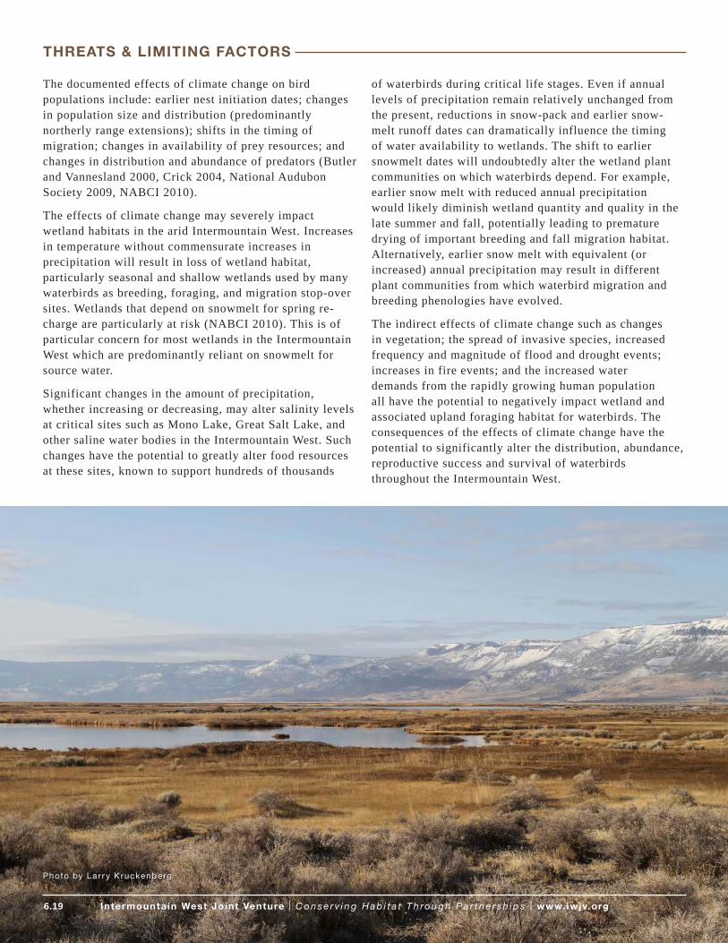
Climate ChangeProfound changes in temperature, precipitation, snowpack, and spring melt dates have already occurred in the IWJV region and more change is predicted for the future. Projections of future climate change vary depending upon the type and scale of models employed to assess the consequences of increased greenhouse gases. Because the IWJV encompasses such a wide variety of ecoregions, the range and scope of predicted climate change also varies greatly across the region.
• Temperature: The Great Basin has experienced region- wide increases in average temperatures of 0.5–1.1° F (Baldwin et al. 2003; Chambers 2008). Although the degree of temperature change has varied across the region, climatologists predict continuing temperature increases in Western North America ranging from about 4–11°F over the next century (IPCC 2007 Working Group I Report). Predictions of rising temperature are further supported by various downscale and regional circulation models for the Great Basin/Rocky Mountain Region, northeastern California, and the Sierra Nevada in eastern California (Baldwin 2003, Bell 2004; Reichler 2009; and PRBO 2011)
• Precipitation: Increases in average annual precipitation ranging from 6–16% throughout most of the Great Basin have been documented with more frequent extreme high-precipitation years (Baldwin 2003; Chambers 2008). Conversely, the southern portions of Nevada, Utah, Colorado, Southeastern California and all portions of Arizona and Mexico within the Intermountain West are experiencing drying climatic conditions (Seager 2007). Recent investigations underscore the high uncertainty about the effects of climate change on annual precipitation across the Intermountain West. In some regions, models predict little change or drier conditions (Chambers 2008, PRBO 2011) while other regional models predict continued increases in precipitation (Baldwin 2003) or wetter winters and drier summers (Reichler 2009). However, portions of the arid southwest are predicted with growing certainty to be increasingly dry (Seager et al. 2007).
• Snowpack and Snowmelt: Significant declines in snowpack and earlier spring snowmelts are well documented in the intermountain west (Mote 2005, Bedford and Douglas 2008). Consistency among climate models strongly suggest continued reductions in snowpack throughout most of the IWJV area, with the potential for extreme reductions of up to 70% in eastern and northeastern California (Mote 2005, PRBO 2011).
THREATS & LIMITING FACTORS
6.19 Intermountain West Joint Venture | C o n s e r v i n g H a b i t a t T h ro u g h P a r t n e r s h i p s | www.iwjv.org
The documented effects of climate change on bird populations include: earlier nest initiation dates; changes in population size and distribution (predominantly northerly range extensions); shifts in the timing of migration; changes in availability of prey resources; and changes in distribution and abundance of predators (Butler and Vannesland 2000, Crick 2004, National Audubon Society 2009, NABCI 2010).
The effects of climate change may severely impact wetland habitats in the arid Intermountain West. Increases in temperature without commensurate increases in precipitation will result in loss of wetland habitat, particularly seasonal and shallow wetlands used by many waterbirds as breeding, foraging, and migration stop-over sites. Wetlands that depend on snowmelt for spring re-charge are particularly at risk (NABCI 2010). This is of particular concern for most wetlands in the Intermountain West which are predominantly reliant on snowmelt for source water.
Significant changes in the amount of precipitation, whether increasing or decreasing, may alter salinity levels at critical sites such as Mono Lake, Great Salt Lake, and other saline water bodies in the Intermountain West. Such changes have the potential to greatly alter food resources at these sites, known to support hundreds of thousands
of waterbirds during critical life stages. Even if annual levels of precipitation remain relatively unchanged from the present, reductions in snow-pack and earlier snow-melt runoff dates can dramatically influence the timing of water availability to wetlands. The shift to earlier snowmelt dates will undoubtedly alter the wetland plant communities on which waterbirds depend. For example, earlier snow melt with reduced annual precipitation would likely diminish wetland quantity and quality in the late summer and fall, potentially leading to premature drying of important breeding and fall migration habitat. Alternatively, earlier snow melt with equivalent (or increased) annual precipitation may result in different plant communities from which waterbird migration and breeding phenologies have evolved.
The indirect effects of climate change such as changes in vegetation; the spread of invasive species, increased frequency and magnitude of flood and drought events; increases in fire events; and the increased water demands from the rapidly growing human population all have the potential to negatively impact wetland and associated upland foraging habitat for waterbirds. The consequences of the effects of climate change have the potential to significantly alter the distribution, abundance, reproductive success and survival of waterbirds throughout the Intermountain West.
Photo by Lar r y K ruckenberg
THREATS & LIMITING FACTORS
6.20 Intermountain West Joint Venture | C o n s e r v i n g H a b i t a t T h ro u g h P a r t n e r s h i p s | www.iwjv.org
Photo by USFWS
Waterbird population estimates in the IWWCP were generated by compiling available inventory and monitoring data from regional, statewide, and local surveys. Expert opinion and data from various sources, years, and survey techniques were collated and used to generate population estimates for 17 of the 39 waterbird species (including the CVP, LCRVP, and RMP breeding populations of Sandhill Cranes) that occur in the IWJV. The IWWCP then established spopulation objectives for these High or Moderate Concern priority waterbird species for each state and BCR. For priority migrant species, population objectives were set for individual sites that support high numbers and were derived from estimates of peak numbers of staging birds using each site. IWWCP population estimates and objectives are lacking for many waterbirds, particularly secretive marsh birds and including some priority species such as Sora and American Bittern.
In 2009–2011 the U.S. Fish and Wildlife Service collaborated with state and NGO partners to plan and implement a comprehensive inventory of colonial
waterbirds in 11 western states, including all states encompassed in the IWJV. Nearly all known and potential waterbird breeding sites within the Intermountain West were surveyed during the initial two year survey effort. Estimates generated from this inventory will represent minimum population sizes and will improve prior estimates because surveys were conducted in a more coordinated, comprehensive, and synchronized manner. Issues stemming from over-counting or undercounting due to temporal and spatial shifts in colony locations among and between years, and incomplete survey coverage should be minimal in comparison to estimates previously generated from discrete survey efforts conducted independently by many entities across many years. These results will provide the IWJV with more current and accurate information on waterbird abundance and distribution which will greatly improve our capacity for waterbird conservation planning.
POPULATION ESTIMATES & OBJECTIVES
6.21 Intermountain West Joint Venture | C o n s e r v i n g H a b i t a t T h ro u g h P a r t n e r s h i p s | www.iwjv.org
FOCAL SPECIES
Focal Species ApproachPractical conservation and management considerations, along with limited data and knowledge of most waterbird populations necessitate, that only a subset of species can be used for future landscape-scale conservation planning at this time. To select focal waterbirds for this Strategy, the WST implemented a process similar to that used by California Partners in Flight for landbird conservation planning (Chase and Guepel 2005). This entailed identifying species associated with important habitat elements or microhabitat attributes, identifying species with special conservation needs, and then selecting a suite of species that together represent the full range of critical ecosystem/habitat elements within the planning area.
To select focal species for IWJV habitat conservation efforts, the WST initially compiled a list of priority species from waterbird conservation plans and federal and state lists of bird conservation priorities.
This list includes waterbirds that are:
1. Ranked as highly imperiled or of high concern in the NAWCP;
2. Ranked as high or moderate concern in the regional IWWCP;
3. Included on USFWS Birds of Conservation Concern (BCC) BCR lists (USFWS 2009); and
4. Identified as priority species in State Wildlife Action Plans (SWAPs).
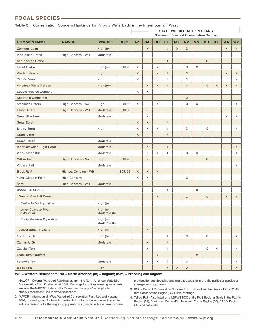
In total, 31 waterbird species and subspecies representing a broad array of taxonomic groups, geographic ranges, abundance, and conservation status were identified as priority species (Table 3). Most of these occur as resident or breeding birds, but migrant Common Loons, Eared Grebes, Lesser Sandhill Cranes, Franklin’s Gulls; and several management populations of Greater Sandhill Cranes that stage at various key locations within the IWJV are also included.
Photo by USFWS
6.22 Intermountain West Joint Venture | C o n s e r v i n g H a b i t a t T h ro u g h P a r t n e r s h i p s | www.iwjv.org
Table 3 Conservation Concern Rankings for Priority Waterbirds in the Intermountain West.
COMMON NAME NAWCP1 IWWCP2 BCC3 AZ CA CO ID MT NV NM OR UT WA WY
Common Loon High (b/m) X X X X X X
Pied-billed Grebe High Concern - WH Moderate
Red-necked Grebe X X
Eared Grebe High (m) BCR 9 X X X X
Western Grebe High X X X X X X
Clark’s Grebe High X X X X
American White Pelican High (b/m) X X X X X X X X
Double-crested Cormorant X X
Neotropic Cormorant X
American Bittern High Concern - NA High BCR 16 X X X X X
Least Bittern High Concern - WH Moderate BCR 33 X
Great Blue Heron Moderate X X X
Great Egret X X X
Snowy Egret High X X X X X X X
Cattle Egret X X
Green Heron Moderate
Black-crowned Night Heron Moderate X X X
White-faced Ibis Moderate X X X X X X
Yellow Rail4 High Concern - NA High BCR 9 X X
Virginia Rail Moderate X
Black Rail5 Highest Concern - WH BCR 33 X X X
Yuma Clapper Rail6 High Concern4 X X X
Sora High Concern - WH Moderate
SANDHILL CRANE X X X
Greater Sandhill Crane X X X X X
Central Valley Population High (b/m)
Lower Colorado River Population
High (m); Moderate (b)
Rocky Mountain Population High (m); Moderate (b)
Lesser Sandhill Crane High (m) X
Franklin’s Gull High (b/m) X X X X
California Gull Moderate X X
Caspian Tern X X X X X
Least Tern (interior) X X
Forster’s Tern Moderate X X X X X
Black Tern High X X X X
WH = Western Hemisphere; NA = North America; (m) = migrant; (b/m) = breeding and migrant
1. NAWCP - Colonial Waterbird Rankings are from the North American Waterbird Conservation Plan, Kushlan et al. 2002; Rankings for solitary- nesting waterbirds are from the NAWCP Update: http://www.pwrc.usgs.gov/nacwcp/pdfs/status_assessment/FinalTableWorksheet.pdf
2. IWWCP - Intermountain West Waterbird Conservation Plan, Ivey and Herziger 2006; all rankings are for breeding waterbirds unless otherwise noted by (m) to indicate ranking is for the migrating population or (b/m) to indicate rankings were
provided for both breeding and migrant populations of a the particular species or management population.
3. BCC - Birds of Conservation Concern, U.S. Fish and Wildlife Service Birds , 2008; Bird Conservation Region (BCR) level rankings.
4. Yellow Rail - Also listed as a USFWS BCC at the FWS Regional Scale in the Pacific Region (R1), Southwest Region(R2), Mountain Prairie Region (R6), CA/NV Region (R8) and nationally.
FOCAL SPECIES
STATE WILDIFE ACTION PLANS Species of Greatest Conservation Concern
6.23 Intermountain West Joint Venture | C o n s e r v i n g H a b i t a t T h ro u g h P a r t n e r s h i p s | www.iwjv.org
5. Black Rail - species occurrence in AZ, CA, and CO are outside the IWJV boundary; Occurrences in NV are from observations in 2003 in the Virgin River and Henderson, NV areas (BCR 33; Floyd et al. 2007); Also listed as a USFWS BCC at the FWS Regional Scale in the Southwest Region(R2), Mountain Prairie Region (R6), CA/NV Region (R8) and nationally.
6. Yuma Clapper Rail - NWACP ranking is for the Yuma subspecies; confirmed breeding in Big Marsh, Clark Co , NV 2001 (Floyd et al. 2007); Also listed as a USFWS BCC at the Regional Scale in the Southwest Region (R2), Mountain Prairie Region (R6), and CA/NV Region (R8)
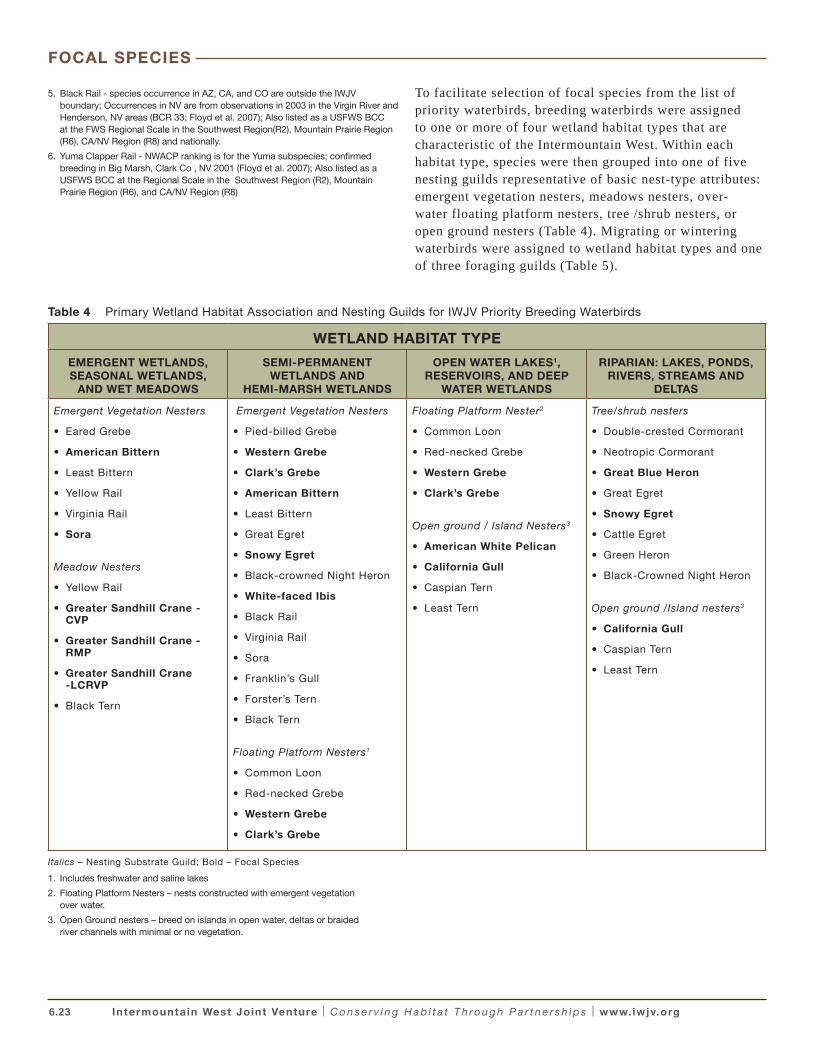
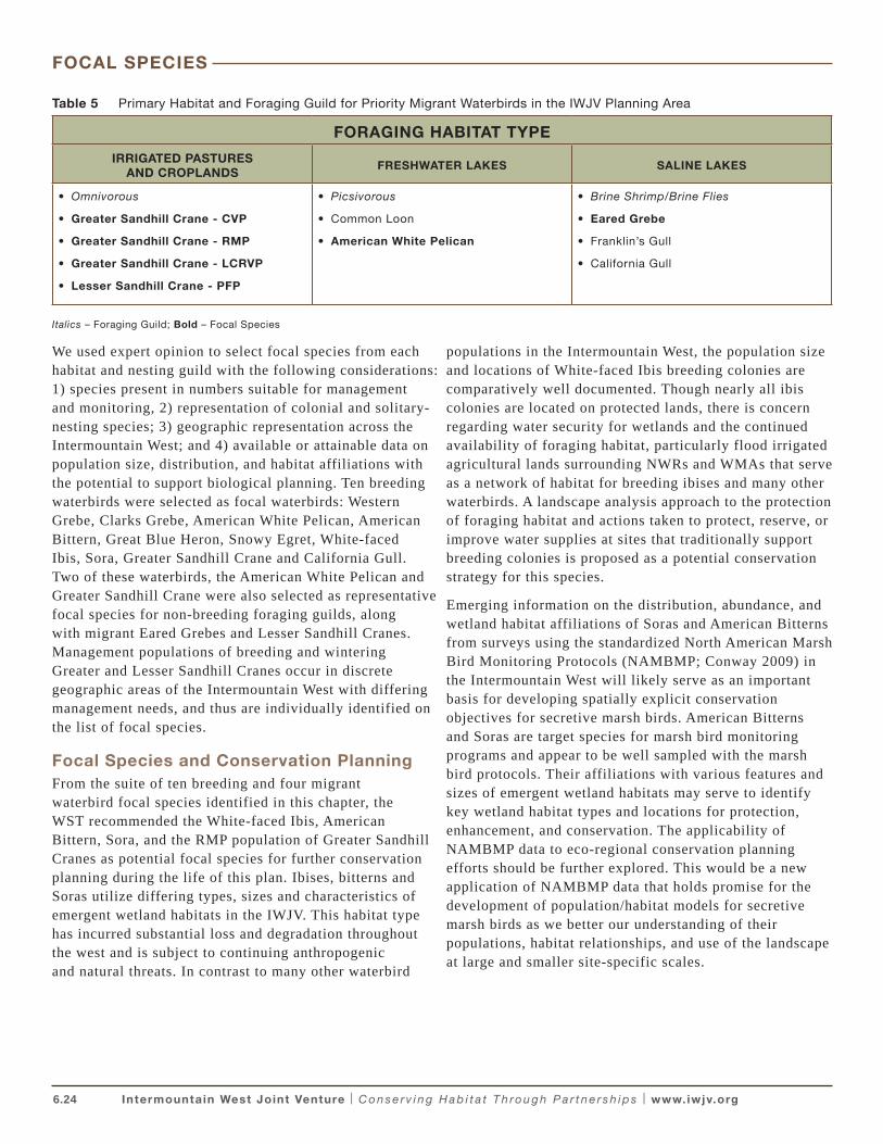
To facilitate selection of focal species from the list of priority waterbirds, breeding waterbirds were assigned to one or more of four wetland habitat types that are characteristic of the Intermountain West. Within each habitat type, species were then grouped into one of five nesting guilds representative of basic nest-type attributes: emergent vegetation nesters, meadows nesters, over-water floating platform nesters, tree /shrub nesters, or open ground nesters (Table 4). Migrating or wintering waterbirds were assigned to wetland habitat types and one of three foraging guilds (Table 5).
Table 4 Primary Wetland Habitat Association and Nesting Guilds for IWJV Priority Breeding Waterbirds
WETLAND HABITAT TYPE
EMERGENT WETLANDS, SEASONAL WETLANDS,
AND WET MEADOWS
SEMI-PERMANENT WETLANDS AND
HEMI-MARSH WETLANDS
OPEN WATER LAKES1, RESERVOIRS, AND DEEP
WATER WETLANDS
RIPARIAN: LAKES, PONDS, RIVERS, STREAMS AND
DELTAS
Emergent Vegetation Nesters
• Eared Grebe
• American Bittern
• Least Bittern
• Yellow Rail
• Virginia Rail
• Sora
Meadow Nesters
• Yellow Rail
• Greater Sandhill Crane - CVP
• Greater Sandhill Crane - RMP
• Greater Sandhill Crane -LCRVP
• Black Tern
Emergent Vegetation Nesters
• Pied-billed Grebe
• Western Grebe
• Clark’s Grebe
• American Bittern
• Least Bittern
• Great Egret
• Snowy Egret
• Black-crowned Night Heron
• White-faced Ibis
• Black Rail
• Virginia Rail
• Sora
• Franklin’s Gull
• Forster’s Tern
• Black Tern
Floating Platform Nesters1
• Common Loon
• Red-necked Grebe
• Western Grebe
• Clark’s Grebe
Floating Platform Nester2
• Common Loon
• Red-necked Grebe
• Western Grebe
• Clark’s Grebe
Open ground / Island Nesters3
• American White Pelican
• California Gull
• Caspian Tern
• Least Tern
Tree/shrub nesters
• Double-crested Cormorant
• Neotropic Cormorant
• Great Blue Heron
• Great Egret
• Snowy Egret
• Cattle Egret
• Green Heron
• Black-Crowned Night Heron
Open ground /Island nesters3
• California Gull
• Caspian Tern
• Least Tern
Italics – Nesting Substrate Guild; Bold – Focal Species
1. Includes freshwater and saline lakes
2. Floating Platform Nesters – nests constructed with emergent vegetation over water.
3. Open Ground nesters – breed on islands in open water, deltas or braided river channels with minimal or no vegetation.
FOCAL SPECIES
6.24 Intermountain West Joint Venture | C o n s e r v i n g H a b i t a t T h ro u g h P a r t n e r s h i p s | www.iwjv.org
Table 5 Primary Habitat and Foraging Guild for Priority Migrant Waterbirds in the IWJV Planning Area
FORAGING HABITAT TYPE
IRRIGATED PASTURES AND CROPLANDS
FRESHWATER LAKES SALINE LAKES
• Omnivorous
• Greater Sandhill Crane - CVP
• Greater Sandhill Crane - RMP
• Greater Sandhill Crane - LCRVP
• Lesser Sandhill Crane - PFP
• Picsivorous
• Common Loon
• American White Pelican
• Brine Shrimp/Brine Flies
• Eared Grebe
• Franklin’s Gull
• California Gull
Italics – Foraging Guild; Bold – Focal Species
We used expert opinion to select focal species from each habitat and nesting guild with the following considerations: 1) species present in numbers suitable for management and monitoring, 2) representation of colonial and solitary-nesting species; 3) geographic representation across the Intermountain West; and 4) available or attainable data on population size, distribution, and habitat affiliations with the potential to support biological planning. Ten breeding waterbirds were selected as focal waterbirds: Western Grebe, Clarks Grebe, American White Pelican, American Bittern, Great Blue Heron, Snowy Egret, White-faced Ibis, Sora, Greater Sandhill Crane and California Gull. Two of these waterbirds, the American White Pelican and Greater Sandhill Crane were also selected as representative focal species for non-breeding foraging guilds, along with migrant Eared Grebes and Lesser Sandhill Cranes. Management populations of breeding and wintering Greater and Lesser Sandhill Cranes occur in discrete geographic areas of the Intermountain West with differing management needs, and thus are individually identified on the list of focal species.
Focal Species and Conservation PlanningFrom the suite of ten breeding and four migrant waterbird focal species identified in this chapter, the WST recommended the White-faced Ibis, American Bittern, Sora, and the RMP population of Greater Sandhill Cranes as potential focal species for further conservation planning during the life of this plan. Ibises, bitterns and Soras utilize differing types, sizes and characteristics of emergent wetland habitats in the IWJV. This habitat type has incurred substantial loss and degradation throughout the west and is subject to continuing anthropogenic and natural threats. In contrast to many other waterbird
populations in the Intermountain West, the population size and locations of White-faced Ibis breeding colonies are comparatively well documented. Though nearly all ibis colonies are located on protected lands, there is concern regarding water security for wetlands and the continued availability of foraging habitat, particularly flood irrigated agricultural lands surrounding NWRs and WMAs that serve as a network of habitat for breeding ibises and many other waterbirds. A landscape analysis approach to the protection of foraging habitat and actions taken to protect, reserve, or improve water supplies at sites that traditionally support breeding colonies is proposed as a potential conservation strategy for this species.
Emerging information on the distribution, abundance, and wetland habitat affiliations of Soras and American Bitterns from surveys using the standardized North American Marsh Bird Monitoring Protocols (NAMBMP; Conway 2009) in the Intermountain West will likely serve as an important basis for developing spatially explicit conservation objectives for secretive marsh birds. American Bitterns and Soras are target species for marsh bird monitoring programs and appear to be well sampled with the marsh bird protocols. Their affiliations with various features and sizes of emergent wetland habitats may serve to identify key wetland habitat types and locations for protection, enhancement, and conservation. The applicability of NAMBMP data to eco-regional conservation planning efforts should be further explored. This would be a new application of NAMBMP data that holds promise for the development of population/habitat models for secretive marsh birds as we better our understanding of their populations, habitat relationships, and use of the landscape at large and smaller site-specific scales.
FOCAL SPECIES
6.25 Intermountain West Joint Venture | C o n s e r v i n g H a b i t a t T h ro u g h P a r t n e r s h i p s | www.iwjv.org
Similarly, completion of the WCWS will provide valuable current data regarding the abundance and distribution of focal waterbirds at a geographic scale appropriate for IWJV conservation planning. These data will be important for increasing our understanding of the temporal dynamics for waterbirds in the Intermountain West that will be required for the development of meaningful conservation strategies. The acquisition and assessment of habitat information appropriate for waterbird conservation planning purposes will be a priority for the IWJV in the upcoming years. Ultimately, conservation planning for focal waterbirds should be initiated in landscapes recognized as key sites for waterbirds. Great Salt Lake in Utah; Southeast Idaho (including the Bear River Basin encompassing wetlands in southeastern Idaho, northeastern Utah and western in Wyoming); Southern Oregon and Northeast California (SONEC); Lahontan Valley and Pyramid Lake Nevada; and the San Luis Valley, Colorado and Upper/Middle Rio Grande Corridor in New Mexico are regions with key wetland complexes of known significance to high priority waterbird species in the Intermountain West (Jehl 1994, Haig 1998, Jehl 1998, Shuford et al. 2006; Ivey and Herziger 2006; Shuford 2010, and others). In most cases, wetland habitat complexes within these regions have a base of waterbird population monitoring data that merits further assessment to determine its suitability for conservation planning purposes, particularly when combined with new information gained from the WCWS.
The development of population-driven habitat objectives for focal waterbirds is proposed for future updates as information on western waterbird populations and wetland inventory and habitat trends improve. In the interim, commensurate planning efforts for landbird conservation may benefit priority waterbirds such as Great Blue Heron and Snowy Egret that typically nest in tree and shrub riparian habitats. Landscape characterizations and objectives based on energetic models developed for shorebirds at the Great Salt Lake and waterfowl at Great Salt Lake and SONEC will also likely benefit waterbirds breeding and migrating in these landscapes, including Western and Clark’s Grebe, California and Franklin’s gulls, Sandhill Crane, and Eared Grebe. Future efforts to build conservation strategies around focal waterbird species will require identification of the appropriate eco-regional scales on which to base planning, and the identification of habitat-related population limiting factors at those same scales. Developing habitat objectives to address limiting factors will require development of spatially explicit conceptual or empirical models dependent upon the availability and utility of population
and habitat data. Development of habitat-suitability models at broad geographic scales may be an informative first step to identify regional extents to focus conservation planning for focal species and establish linkages to regional population objectives. Ultimately, future planning efforts should identify spatially explicit habitat objectives that can be linked to programmatic objectives, conservation treatments, and biological outcomes that address identified limiting factors. Ideally, habitat inventory and population monitoring programs at these same eco-regional scales should be developed to inform whether conservation is successful and consistent with expected biological outcomes.
Focal Species Profiles
Photo by Dave Menke
White-faced Ibis: The White-faced Ibis is a colonial waterbird that breeds in freshwater hemi-marsh habitat where emergent vegetation is interspersed with open water. In the Great Basin region, ibises most commonly nest in stands of hardstem
bulrush or cattails (Ryder and Manry1994). These semi-permanent wetlands are susceptible to highly variable drought and flood conditions, a defining characteristic of the Great Basin ecoregion. In response to these cyclic conditions and within-year variation in local habitat conditions, ibis colony locations shift both spatially and temporally (Ivey et al. 1988, Taylor et al. 1989, Jehl 1994, Earnst et al. 1998). When conditions at traditional nesting sites are poor, ibis move among other colony sites or rapidly colonize new sites with suitable nesting habitat
White-faced Ibis are opportunistic foragers that feed in receding wetlands and newly flooded habitats where moist-soil invertebrate prey is concentrated. Seasonal wetlands, shallow lake shores, mudflats, shallowly flooded pond margins, reservoirs, and marshes are typical foraging habitats (Taylor et al.. 1989, Ryder and Manry 1994). Irrigated agricultural lands are important feeding sites, particularly native hay meadows, pastures, and alfalfa and barley fields within 4 miles of breeding areas (Capen 1977, Bray and Klebenow 1988). Ibis also forage in flooded, grazed pastures even in areas where various agricultural crops are also available (Follansbee 1994). Flooded pastures, and irrigated agricultural lands are a source of earthworms, a particularly important prey item (Bray and Klebenow 1988).
The selection of White-faced Ibis as a one of the focal species for conservation planning addresses several key considerations for wetland habitat conservation in the Intermountain West area. Their nomadic breeding strategy exemplifies the ecological connectivity among wetlands
FOCAL SPECIES
6.26 Intermountain West Joint Venture | C o n s e r v i n g H a b i t a t T h ro u g h P a r t n e r s h i p s | www.iwjv.org
in the Great Basin and indicates that wetland management decisions should be made in a regional context (Earnst et al. 1998, Jehl 1998, Taylor et al. 1989). Conservation of nesting and foraging habitat for this waterbird will require a network of emergent wetlands and surrounding irrigated agricultural and wet pasture habitat at the landscape scale. These habitats are known to support a wide variety of nesting, migrating, and wintering waterbirds but have been subject to significant levels of historic and contemporary habitat loss and degradation. The conservation of habitat in support of White-faced Ibis breeding colonies and associated irrigated agricultural and pasture lands is thus intended to benefit a suite of waterbirds affiliated with these same habitats, including breeding Western and Clark’s grebes, Black-crowned Night-Heron, Franklin’s Gull and Forster’s Tern and foraging Sandhill Crane, Great Blue Heron, and Cattle Egret. In this manner, ibis may function as an “umbrella species” in that the protection of habitat for ibis provides for the needs of a larger suite of co-occurring species (Caro and O’Doherty 1999, Fleishman et al. 2001, Chase and Guepel 2005).
Photo by Dan Casey
Sora: This species is a solitary-nesting migratory rail that breeds throughout the Intermountain West area in freshwater wetland marshes with dense stands of cattail, bulrush, and sedge. Breeding Soras are typically found near edges between
vegetation types among patches of open water and in the shallow, shoreward portions of wetlands where water level instability produces diverse mosaics of fine and robust emergent vegetation (Melvin and Gibbs 1996). Their nests are constructed over water with emergent vegetation and include a characteristic ramp and an overhead canopy built from surrounding vegetation. Wetland edges and upland fields, including row crops, adjacent to wetlands are sometimes used for brood-rearing or post-breeding dispersal (Kantrud and Stewart 1984; Johnson and Dinsmore 1986). Soras feed in stands of robust emergent vegetation interspersed with shorter, seed-producing emergents. They are primarily seed-eaters, consuming seeds of smartweeds, sedges, bulrushes and grasses, but also consume some aquatic invertebrates found near the water surface, often in areas with floating and submergent vegetation and debris (Melvin and Gibbs 1996). In contrast to White-faced Ibis that typically colonize breeding habitat within relatively large wetland complexes (e.g. Lahonton Wetlands, Nevada; Malheur NWR, Oregon, Blackfoot Reservoir, Idaho) Soras are relatively area-independent and wider ranging in their selection of wetlands and have been found breeding in wetlands < 0.05 ha in size (Melvin and Gibbs 1996).
Until recent years, information on the distribution and abundance of Soras was primarily limited to BBS data and state bird atlases. These methods and datasets are insufficient for estimating population size or trends, and thus the IWWCP did not provide population estimates or objectives for Soras. In 2004, secretive marsh-bird surveys using the North American Marsh Bird Survey (NAMBS) protocols were initiated at some sites in the Intermountain West. Soras are a target species for these tape-playback surveys. By 2009, these standardized surveys were underway at many locations sites within the Intermountain West. An analysis of survey results may aid in establishing population estimates, population objectives, and nesting densities for various wetland habitat types used by Soras in the southeastern Idaho, SONEC, and GSL focal areas; and potentially the Intermountain West in its entirety. Consequently, further exploration into the utility of NAMBS data for landscape-scale conservation planning is warranted.
Photo by USFWS
American Bittern: This is a northerly breeding heron that inhabits tall emergent vegetation in freshwater wetlands. The American Bittern is a solitary-nesting, crepuscular waterbird with cryptic plumage. Little information is available about the
species habitat preferences in the western U.S., but studies in the northeastern and midwestern states found that American Bitterns most frequently occupy palustrine emergent, scrub-shrub, and aquatic bed wetlands (Gibbs et al. 1992). These wetland types are similar to those used by Sora but the two species differ substantially in nest structure, diet, and foraging habits. American Bitterns feed at vegetation fringes and shorelines of wetlands dominated by tall emergent vegetation, avoiding older, dense, or dry vegetation (Gibbs et al. 1992). Dense stands of decadent emergents do not appear to be beneficial to this species. In contrast to the primarily seed-eating Sora, American Bitterns consume insects, fish, crustaceans, snakes and small mammals, relying on stealth more than pursuit to capture prey (Gibbs et al. 1992). The platform nest is typically placed in dense emergent vegetation over water of 2–8 inches in depth; upland habitats modified by agricultural practices are not used for breeding. This waterbird is likely area-dependant and the preservation of large (>25 acres), shallow wetlands with dense growth of robust emergents has been identified as the most urgent need for the conservation of this species (Gibbs 1991).
FOCAL SPECIES
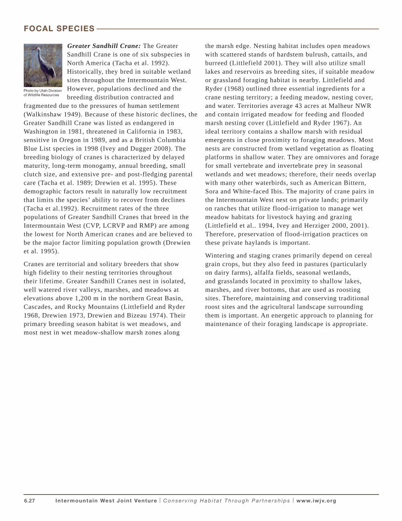
6.27 Intermountain West Joint Venture | C o n s e r v i n g H a b i t a t T h ro u g h P a r t n e r s h i p s | www.iwjv.org
Photo by Utah Division of Wildlife Resources
Greater Sandhill Crane: The Greater Sandhill Crane is one of six subspecies in North America (Tacha et al. 1992). Historically, they bred in suitable wetland sites throughout the Intermountain West. However, populations declined and the breeding distribution contracted and
fragmented due to the pressures of human settlement (Walkinshaw 1949). Because of these historic declines, the Greater Sandhill Crane was listed as endangered in Washington in 1981, threatened in California in 1983, sensitive in Oregon in 1989, and as a British Columbia Blue List species in 1998 (Ivey and Dugger 2008). The breeding biology of cranes is characterized by delayed maturity, long-term monogamy, annual breeding, small clutch size, and extensive pre- and post-fledging parental care (Tacha et al. 1989; Drewien et al. 1995). These demographic factors result in naturally low recruitment that limits the species’ ability to recover from declines (Tacha et al.1992). Recruitment rates of the three populations of Greater Sandhill Cranes that breed in the Intermountain West (CVP, LCRVP and RMP) are among the lowest for North American cranes and are believed to be the major factor limiting population growth (Drewien et al. 1995).
Cranes are territorial and solitary breeders that show high fidelity to their nesting territories throughout their lifetime. Greater Sandhill Cranes nest in isolated, well watered river valleys, marshes, and meadows at elevations above 1,200 m in the northern Great Basin, Cascades, and Rocky Mountains (Littlefield and Ryder 1968, Drewien 1973, Drewien and Bizeau 1974). Their primary breeding season habitat is wet meadows, and most nest in wet meadow-shallow marsh zones along
the marsh edge. Nesting habitat includes open meadows with scattered stands of hardstem bulrush, cattails, and burreed (Littlefield 2001). They will also utilize small lakes and reservoirs as breeding sites, if suitable meadow or grassland foraging habitat is nearby. Littlefield and Ryder (1968) outlined three essential ingredients for a crane nesting territory; a feeding meadow, nesting cover, and water. Territories average 43 acres at Malheur NWR and contain irrigated meadow for feeding and flooded marsh nesting cover (Littlefield and Ryder 1967). An ideal territory contains a shallow marsh with residual emergents in close proximity to foraging meadows. Most nests are constructed from wetland vegetation as floating platforms in shallow water. They are omnivores and forage for small vertebrate and invertebrate prey in seasonal wetlands and wet meadows; therefore, their needs overlap with many other waterbirds, such as American Bittern, Sora and White-faced Ibis. The majority of crane pairs in the Intermountain West nest on private lands; primarily on ranches that utilize flood-irrigation to manage wet meadow habitats for livestock haying and grazing (Littlefield et al.. 1994, Ivey and Herziger 2000, 2001). Therefore, preservation of flood-irrigation practices on these private haylands is important.
Wintering and staging cranes primarily depend on cereal grain crops, but they also feed in pastures (particularly on dairy farms), alfalfa fields, seasonal wetlands, and grasslands located in proximity to shallow lakes, marshes, and river bottoms, that are used as roosting sites. Therefore, maintaining and conserving traditional roost sites and the agricultural landscape surrounding them is important. An energetic approach to planning for maintenance of their foraging landscape is appropriate.
FOCAL SPECIES
6.28 Intermountain West Joint Venture | C o n s e r v i n g H a b i t a t T h ro u g h P a r t n e r s h i p s | www.iwjv.org
Western Colonial Waterbird Survey, 2009–2011
Survey Objectives:
• Document species composition, size, and location of colonial waterbird breeding colonies from 2009 – 2011 in 11 western states.
• Estimate the minimum population size of waterbird species within the project area.
• Produce an atlas of western colonial waterbird breeding colonies, 2011-2013.
• Establish a benchmark for the development of a long-term monitoring program for colonial waterbirds in the west.
The Western Colonial Waterbird Survey (WCWS) was initiated in 2009 to inventory the location and abundance of 17 species of waterbirds in 11 western states. The survey was coordinated by the USFWS and implemented by state wildlife agencies and nongovernmental partners in 2009–2011 (http://www.fws.gov/mountain-prairie/species/birds/western_colonial/index.html). Raw data from some states and for some species has been provided for use in this Strategy by the USFWS and WCWS partners (i.e. USFWS Regions 1 and 6, Idaho Department of Fish and Game, Klamath Bird Observatory, Great Basin Bird Observatory, Nevada Department of Wildlife, and Point Reyes Bird Observatory). Publication of final results and an associated Waterbird Colony Atlas are scheduled for 2013.
Most WCWS field surveys in the Intermountain West were completed in 2009 and 2010. The WCWS is the first comprehensive survey for waterbirds conducted within a specific time period in a coordinated manner throughout the western states. Survey results will serve to refine waterbird population estimates in the IWWCP, many of which were generated by combining population data from many sources and across multiple years. Population estimates derived from WCWS inventory data will represent minimum population sizes and will improve upon estimates derived from individual site surveys conducted independently across many years.
North American Marsh Bird Monitoring
Monitoring Objectives:
• Document the presence or distribution of marsh birds within a defined area.
• Estimate or compare density of secretive marsh birds among management units, wetlands, or regions.
• Estimate population trend for marsh birds at local or regional scale.
• Evaluate effects of management actions (often actions that target other species) on secretive marsh birds
Efforts have been underway for the past decade to develop and field test continental survey protocols for marsh birds in North America (Conway and Timmermans 2005). Marsh birds are difficult to survey due to their inconspicuous behavior and cryptic characteristics. Standardized North American Marsh Bird Monitoring Protocols (NAMBMPs) have been developed, field tested, and implemented on many NWRs, state Wildlife Management Areas, and other locations (Conway 2009). Waterbirds included as focal species in these surveys include Clapper Rail, Sora, Virginia Rail, Least Bittern, and American Bittern. The NAMBMPs were first implemented on sites within the IWJV area in 2004 by the Idaho Department of Fish and Game. Additional surveys have since been added throughout the region by state, federal, and nongovernmental cooperators. Surveys have been implemented in all of the states within the IWJV with implementation ranging from one to eight years at individual survey sites. Although results from these marsh bird surveys were produced in years when survey protocols and the continental marsh bird monitoring program were still in the development and assessment stage, this information may offer the best opportunity to better estimate population sizes, nesting densities, and habitat associations of these secretive marsh bird species.
POPULATION INVENTORY & MONITORING
6.29 Intermountain West Joint Venture | C o n s e r v i n g H a b i t a t T h ro u g h P a r t n e r s h i p s | www.iwjv.org
The number and duration of NAMBMPs vary across the region including surveys in three areas of particular significance to waterbirds:
• In 2004 Idaho Department of Fish and Game conducted 10 pilot marsh bird surveys at two sites. In 2005, 65 marsh bird surveys were conducted at 12 sites throughout the state (Moulton and Sallabanks, 2006). Additional annual survey routes have been added over time and surveys were conducted at 29 wetland sites in 2008.
• At Great Salt Lake, eight survey routes began in 2007.Focal species include American Bittern, Virginia Rail, and Sora. Secondary species include Pied-billed Grebe and American Coot.
• In eastern Oregon, Klamath Bird Observatory established and implemented marsh bird surveys on 10 areas in 2008 including six sites in the Klamath Basin (Bruce et al. 2008). Surveys at some sites were conducted in 2010. Marsh bird surveys at Ladd Marsh, eastern Oregon were implemented 2006–2008 (K. Novak, ODFW pers com)
Continental Marsh Bird Monitoring Pilot StudyIn 2008, the USFWS Division of Migratory Management, in cooperation with multiple partners, initiated a pilot study to examine the feasibility of a nationwide survey for secretive marsh birds. Survey objectives are to estimate species-specific: (1) temporal trends in abundance; (2) changes in abundance from year to year; and (3) habitat associations at multiple spatial scales (Seamans 2009). The North American Marsh Bird Monitoring Protocols (Conway 2009) are proposed for use in this developing large-scale monitoring program, and survey routes will be chosen as part of a continental sampling design. The survey will be designed to allow for inference to population status at regional flyway, and continental scales. The design is flexible and allows for more intensive surveys within pre-determined strata such as states, wildlife management areas, or bird conservation regions (Seamans 2009). Four states and the District of Columbia have participated in the pilot study. Idaho Department of Fish and Game has participated in the pilot effort since 2009, and Idaho is the only western state represented in the study.
Periodic or Annual Waterbird Surveys
Inland Breeding Colonial Waterbird Surveys (California)From 1997–1999 PRBO Conservation Science (PRBO) and collaborators conducted a study to document the distribution and abundance of seven species of inland-breeding waterbirds in California (Shuford 2010). This survey established the first statewide baseline inventory of seven waterbird species during the breeding season: American White Pelican, Double-crested Cormorant, Ring-billed Gull, California Gull, Caspian Tern, Black Tern, and Forester’s Tern. Surveys for these species were repeated in the Klamath Basin, including sites in southeastern Oregon, and particularly at Clear Lake and Lower Klamath NWRs, during 2003 and 2004 (Shuford et al. 2006). This suite of seven colonial nesting waterbirds was again surveyed throughout northeastern California in 2009 and 2010 during the WCWS (Shuford and Henderson 2010).
Mono Lake Waterbird Surveys – PRBO has monitored California Gull breeding colonies on Mono Lake annually since 1983 (Shuford 2010). Surveys are conducted to measure annual variation in population size and reproductive success as they relate to changing lake levels and other environmental conditions (Nelson and Greiner 2010).
Idaho Bird Inventory and Survey (IBIS)In 2004 the Idaho Department of Fish and Game initiated this statewide coordinated all-bird monitoring program that addresses monitoring priorities identified in the Idaho Partners in Flight Bird Conservation Plan (Idaho Partners in Flight 2000) and in the bird monitoring components of Idaho’s Comprehensive Wildlife Conservation Strategy.
Phase I of IBIS has focused on aquatic birds, a group for which updated monitoring information was the most lacking in Idaho. Preliminary work began in spring of 2004 and was greatly expanded in 2005 through 2007. A three year inventory of 29 wetland sites was completed in 2007, and new sites were added in 2008 through 2010. Thus far, aquatic bird monitoring under the IBIS framework includes three survey types: general aquatic bird surveys, secretive marsh bird surveys, and colonial waterbird counts. At this time, Idaho Department Fish and Game plans to continue implementation of the IBIS for these waterbirds on an annual basis
POPULATION INVENTORY & MONITORING
6.30 Intermountain West Joint Venture | C o n s e r v i n g H a b i t a t T h ro u g h P a r t n e r s h i p s | www.iwjv.org
Great Salt Lake Waterbird Survey (Utah)The Utah Division of Wildlife Resources initiated the Great Salt Lake (GSL) Waterbird Survey (WBS) in 1997. This was a five-year effort to catalog migratory waterbirds over a variety of the most productive habitats in the Great Salt Lake ecosystem (http://www.wildlife.utah.gov/gsl/waterbirdsurvey); (Paul and Manning 2002). The WBS included surveys of loons, grebes, pelicans, ibis, cranes, rails, herons, gulls, and terns. Waterbird surveys were conducted by state, federal, and private cooperators every 10 days from April through September at 50 different survey areas.
Following this five-year survey, the lake level began to drop, and a second survey from 2004 to 2006 was initiated to document waterbird numbers during a period of relatively low lake levels. This three-year survey focused on 22 focal survey areas with surveys conducted during peak spring (April 15–May 14) and fall (July 8–September 5) migration. Following the three-year WBS there was shift to a Coordinated Bird Monitoring (CBM) Bart et al.) approach in order to sustain waterbird monitoring at GSL. There are now 13 permanent annual and 11 rotational (once every three years) waterbird surveys. Survey periods lengthened to 15 days but lessened in number, with surveys conducted during spring and fall migration.
Columbia Plateau Piscivorous Waterbird Colony Surveys (Washington)In 2004–2009 Roby et al. (2011) monitored the size and population trends of piscivorous waterbird colonies in the Columbia Plateau region of Washington. The species monitored included Caspian Terns, Double-crested Cormorants, American White Pelicans, California Gulls, and Ring-billed Gulls. Eighteen sites were monitored, including 4 islands in the mid Columbia River; 3 islands near the confluence of the Snake and Columbia Rivers; Potholes Reservoir; the mouth of the Okanogan River; Goose and Twining islands in Banks Lake; Harper Island in Sprague Lake; and the Lyons Ferry Railroad trestle on the Snake River. Colonies at these sites have a history of, or are suspected of, preying on juvenile salmonids of conservation concern. In addition to colony size, nesting success and potential limiting factors for colonies of piscivorous waterbirds in the study area were investigated. At the time of this writing, implementation of annual monitoring efforts described in this region are ongoing.
Oregon Coordinated Aquatic Bird Monitoring ProgramThis program, led by the Klamath Bird Observatory, works to facilitate coordinated monitoring efforts to address priority information gaps and inform aquatic bird and wetland conservation. This program contributes to regional, national, and international efforts such as the USFWS Western Colonial Waterbird Survey and the Marsh Birds Population Assessment and Monitoring Project. Through this program Klamath Bird Observatory has created Important Aquatic Bird Site Descriptions for Oregon and northwestern California. Site descriptions are available online at www.klamathbird.org/science/aquaticbirds.html and include information such as seasonal bird presence, water levels, conservation issues, information gaps, existing monitoring programs, land ownership, contact information, and maps. With continued input from partners, the site descriptions will provide current information to land managers, scientists, and bird enthusiasts. This information is intended to inform resource management decisions about restoration, water management, and other activities that effect wetland ecosystem function.
Species-Specific SurveysOf the 38 waterbird species that occur in the Intermountain West only 5 are routinely monitored at the population or IWJV scale: including Eared Grebes, hunted populations of Greater Sandhill Cranes (RMP and LCRVP), Double-crested Cormorants, American White Pelican, and Caspian Tern.
Eared Grebe: Starting in 1996 at Mono Lake and 1997 at Great Salt Lake, a systematic aerial photo technique developed by Boyd and Jehl (1998) was utilized to survey enormous concentrations of Eared Grebes during the fall molt/staging period (Neill et al. 2009; Mono Lake Research Community 2011). This survey is completed in October and has been implemented in most years since first initiated.
Sandhill Cranes: Monitoring occurs annually for the RMP and LCRVP Sandhill Cranes. These populations have regulated hunting seasons and monitoring is specifically designed to determine population trends. For the RMP, a cooperative 5-state (Utah, Colorado, Idaho, Wyoming and Montana) September pre-migration staging-area survey has been in place since 1995 (Kruse et al. 2011). No other crane population co-mingles with the RMP cranes
POPULATION INVENTORY & MONITORING
6.31 Intermountain West Joint Venture | C o n s e r v i n g H a b i t a t T h ro u g h P a r t n e r s h i p s | www.iwjv.org
during that time. The trend for the LCRVP is determined from a winter aerial cruise survey which covers the four main winter concentration areas in southwest Arizona and southeast California, and has been conducted since 1998 (Kruse 2011). With the exception of recent partial LCRVP breeding population surveys conducted in Nevada by Nevada Department of Wildlife and University of Nevada, Reno in 2009-10, and annual monitoring of Central Valley Population (CVP) cranes in the State of Washington, near Conboy Lake National Wildlife Refuge, no recent breeding population surveys have been conducted. Surveys of CVP breeding populations in California and Oregon were last conducted in 2000 (Ivey and Herziger 2000, 2001).
Double-Crested Cormorant: In 2009, Adkins et al. (2010) conducted aerial and ground surveys and collaborated with other agencies and individuals to locate and document all active breeding colonies of Double-crested Cormorants (>25 breeding pairs) in the Western Population. Nearly all of the Intermountain West was included, including colonies in eastern Washington, eastern Oregon, Idaho, northeastern California, Nevada, Utah, Arizona and the portions of Montana, Wyoming, Colorado and New Mexico lying west of the Continental Divide. Surveys for this species in 2009 and 2010 were also conducted throughout the IWJV as part of the WCWS. Numbers of pairs at Double-crested Cormorant breeding colonies in the Intermountain West were frequently monitored by local biologists and land managers prior to these most recent surveys, but comprehensive and complete annual surveys of colonies in the IWJV area were lacking.
American White Pelican: Nearly all breeding colonies of this waterbird in the Intermountain West are routinely surveyed annually by state or Federal agency personnel. Idaho colonies have been monitored annually since 1989 at Mindoka NWR and since 202 at Blackfoot Reservoir (Sallabanks 2009). The colony on Gunnison Island, Great Salt Lake was monitored using ground-based surveys from 1963–1975. Aerial surveys were initiated in 1976 and are conducted in most years as part of the Great Salt Lake Waterbird Survey. The single pelican colony on Badger Island in the Mid Columbia River was monitored 2004–2010 (Roby et al. 2011). Colonies in northeastern California at Clear Lake and Lower Klamath NWRs in the Klamath Basin have been monitored annually since 1952, with prior years monitored sporadically (Shuford 2010; Mauser pers com).
Caspian Tern: In response to concerns regarding the population growth, distribution, and potential impact of tern predation on endangered and threatened salmonids in the Columbia River, the USFWS and PRBO coordinated and collated annual surveys of Caspian Tern colonies and numbers of breeding pairs in the Pacific Region in 2000–2008. The Pacific Region population includes terns breeding in California, Oregon, Washington, Idaho, Nevada, Montana, and Wyoming (Wires et al. 2000). Counts of breeding terns on colonies were conducted by representatives of various Federal, state, and non-governmental agencies and organizations. In Washington, Caspian Terns in the Mid Columbia River and Columbia Plateau are monitored annually (Roby et al. 2011). Surveys for this species in 2009 and 2010 were conducted throughout the Intermountain West as part of the WCWS.
POPULATION INVENTORY & MONITORING
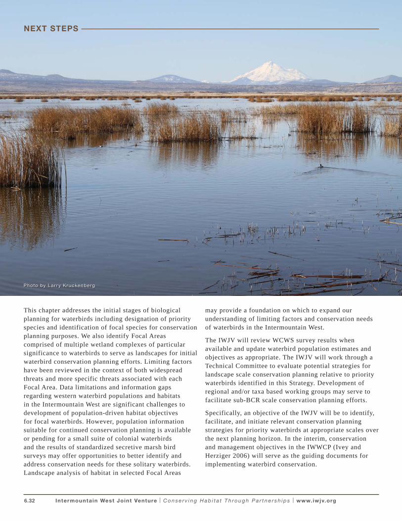
6.32 Intermountain West Joint Venture | C o n s e r v i n g H a b i t a t T h ro u g h P a r t n e r s h i p s | www.iwjv.org
NEXT STEPS
This chapter addresses the initial stages of biological planning for waterbirds including designation of priority species and identification of focal species for conservation planning purposes. We also identify Focal Areas comprised of multiple wetland complexes of particular significance to waterbirds to serve as landscapes for initial waterbird conservation planning efforts. Limiting factors have been reviewed in the context of both widespread threats and more specific threats associated with each Focal Area. Data limitations and information gaps regarding western waterbird populations and habitats in the Intermountain West are significant challenges to development of population-driven habitat objectives for focal waterbirds. However, population information suitable for continued conservation planning is available or pending for a small suite of colonial waterbirds and the results of standardized secretive marsh bird surveys may offer opportunities to better identify and address conservation needs for these solitary waterbirds. Landscape analysis of habitat in selected Focal Areas
may provide a foundation on which to expand our understanding of limiting factors and conservation needs of waterbirds in the Intermountain West.
The IWJV will review WCWS survey results when available and update waterbird population estimates and objectives as appropriate. The IWJV will work through a Technical Committee to evaluate potential strategies for landscape scale conservation planning relative to priority waterbirds identified in this Strategy. Development of regional and/or taxa based working groups may serve to facilitate sub-BCR scale conservation planning efforts.
Specifically, an objective of the IWJV will be to identify, facilitate, and initiate relevant conservation planning strategies for priority waterbirds at appropriate scales over the next planning horizon. In the interim, conservation and management objectives in the IWWCP (Ivey and Herziger 2006) will serve as the guiding documents for implementing waterbird conservation.
Photo by Lar r y K ruckenberg
6.33 Intermountain West Joint Venture | C o n s e r v i n g H a b i t a t T h ro u g h P a r t n e r s h i p s | www.iwjv.org
Adkins, J. Y. and D. D. Roby. 2010. A status assessment of the Double-crested Cormorant (Phalacorcorax auritus) in western North America. USGS – Oregon Cooperative Fish and Wildlife Research Unit 104 Nash Hall, Oregon State University, Corvallis, Oregon 97331-3803
American Ornithologists’ Union. 1983. Checklist of North American Birds, 6th Edition.
Baldwin, C.K., F.H. Wagner, and U. Lall. 2003. Water resources. Pp. 79-112 in F.H. Wagner (ed). Rocky Mountain/Great Basin Regional Climate-Change Assessment. Report for the U. S. Global Change Research Program. Utah State University, Logan, Utah: IV + 240 pp.
Bedford, D. and A. Douglass. 2008. Changing Properties of Snowpack in the Great Salt Lake Basin, Western United States, from a 26-Year SNOTEL Record. The Professional Geographer, 60:3, 374 — 386. : http://dx.doi.org/10.1080/00330120802013646
Bell, J. L., L.C. Sloan, and M.A. Snyder. 2004. Regional Changes in Extreme Climatic Events: A Future Climate Scenario. American Meteorological Society (17): 81-87
Belovsky, G. E., D. Stephens, C. Perschon, P. Birdsey, D. Paul, D. Naftz, R. Baskin, C. Larson, C. Mellison, J. Luft, R. Mosley, H. Mahon, J. Van Leeuwen, and D. V. Allen. 2011. The Great Salt Lake ecosystem (Utah, USA): long term data and a structural equation approach. Ecosphere 2:1–40.
Bishop, C.E., M. Lowe, J. Wallace, R.L. Emerson and J.S. Horn. 2009. Wetlands in the Farmington Bay Area, Davis County: An evaluation of threats posed by ground-water development and drought. Report of Investigation 264. Utah Geological Survey RI 264 (CD).
Bookhout, T.A. 1995. Yellow Rail (Coturnicops noveboracensis). In The Birds of North America, No. 139 (A. Poole and F. Gill, eds.). The Academy of Natural Sciences, Philadelphia, and the American Ornithologists’ Union, Washington DC.
Boyd, S. 2007. Mono Lake Newsletter. www.monolake.org.
Boyd, S. and J.R. Jehl, Jr. 1998. Estimating the abundance of Eared Grebes on Mono Lake, California, by aerial photography. Colonial Waterbirds 21:236-241.
Bray, M. P. and D. A. Klebanow. 1988. Feeding Ecology of White-faced Ibis in a Great Basin Valley, USA. Colonial Waterbirds 11-1: 24-31.
Bruce, J., J. L. Stephens, J. D. Alexander, and N. David. 2009. Oregon Coordinated Aquatic Bird Monitoring: 2008
Secretive Marsh Bird Effort Report, Unpublished Report, 9 pp. Klamath Bird Observatory, Ashland, Oregon.
Butler, R. W. and R.G. Vennesland. 2000. Integrating climate change and predation risk with wading bird conservation research in North America. Waterbirds 23 (3): 535-540
Bystrak, D. 1981. The North American Breeding Bird Survey. Pages 34-41 in C.J. Ralph and J.M. Scott, eds. Estimating numbers of terrestrial birds. Studies in Avian Biology No. 6.
Capen, D. E. 1977. The impact of pesticides on the White-faced Ibis. Ph.D. dissertation. Utah State University, Logan, Utah.
Caro T.M., and G. O’Doherty. 1999. On the use of surrogate species in conservation biology. Conservation Biology, 13(4): 805-814
Chambers, J.C. 2008. Climate Change and the Great Basin. USDA Forest Service. General Technical Report. Rocky Mountain Research Station. GTR-204.
Chase, M. K. and G. R. Guepel. 2005. The use of Avian Focal Species for Conservation Planning in California. USDA Forest Service General Technical Report. PSW-GTR-191.
Conway, C. J. 2009. Standardized North American Marsh Bird Monitoring Protocols, version 2009-2. Wildlife Research Report #2009-02. U.S. Geological Survey, Arizona Cooperative Fish and Wildlife Research Unit, Tucson, Arizona.
Conway, C. J. and S.T.A. Timmermans. 2005. Progress toward developing field protocols for a North American marsh bird monitoring program. Pages 997-1005 in Ralph and T.D. Rich, editors. Bird Conservation Implementation and Integration in the Americas: Proceedings of the Third International Partners in Flight Conference, 20-24 March 2002, Asilomar, California. Volume 2. U.S. Department of Agriculture General Technical Report PSW-GTR-191. Pacific Southwest Research Station, Forest Service, Albany, California.
Cooper, D. S. 2004. Important Bird Areas of California. Audubon California, Los Angeles, California.
Crick, H.Q. 2004. The impact of climate change on birds. Ibis, 146(Suppl.1), 48-56.
Dahl, T.E. 1990. Wetlands losses in the United States, 1780’s to 1980’s. U.S. Department of the Interior, Fish and Wildlife Service, Washington, D.C. 13 pp.
LITERATURE CITED
6.34 Intermountain West Joint Venture | C o n s e r v i n g H a b i t a t T h ro u g h P a r t n e r s h i p s | www.iwjv.org
Dahl, T.E. 2006. Status and trends of wetlands in the conterminous United States 1998 to 2004.U.S. Department of the Interior; Fish and Wildlife Service, Washington, D.C. 112 pp.
Downard, R. 2010. Keeping wetlands wet: The hydrology of wetlands in the Bear River Basin. 2010. All Graduate Thesis and Dissertations. Paper 829. Utah State University. Graduate Studies, School of DigitalCommons@USU. http://digitalcommons.usu.etd/829
Drewien, R. C. 1973. Ecology of Rocky Mountain Greater Sandhill Cranes. Dissertation, University of Idaho, Moscow.
Drewien, R. C., and E. G. Bizeau. 1974. Status and distribution of greater sandhill cranes in the Rocky Mountains. Journal of Wildlife Management 38:720-742.
Drewien, R. C., W. M. Brown and W. L. Kendall. 1995. Recruitment in Rocky Mountain Greater Sandhill Cranes and comparisons with other crane populations. Journal of Wildlife Management 59: 339-356.
Earnst, S.L., L. Neel, G.L. Ivey, and T. Zimmerman. 1998. Status of the White-faced Ibis: Breeding Colony Dynamics of the Great Basin Population, 1985 – 1997. Colonial Waterbirds: 20-3: 301-476.
Engilis A., Jr, and F. A Reid. 1996. Challenges in wetland restoration of the western Great Basin. International Wader Studies 9:71-79.
Fleishman, E., D.D. Murphy, and P.F. Brussard. 2000. A new method for selection of umbrella species for conservation planning. Ecological Applications 10 (2):569-579.
Fleishman, E., R.B. Blair, and D.D. Murphy. 2001. Empirical validation of a method for umbrella species selection. Ecological Applications, 11(5): 1489-1501.
Floyd, T., C .S. Elphick, G. Chisholm, K. Mack, R.G. Elston, E.M. Ammon, and J.D. Boone. 2007. Atlas of the Breeding Birds of Nevada. University of Nevada Press. Reno, Nevada.
Follansbee, D. M. and D. M. Mauser. 1994. Ecology of breeding White-faced Ibis on Lower Klamath NWR, CA. Unpublished progress report.
Gibbs, J. P., S. Melvin, and F.A. Reid. 1992. American Bittern. In the Birds of North America, No. 18 (A. Poole, P. Stettenheim, and F. Gill, Eds.). Philadelphia: The Academy of Natural Sciences; Washington, DC: The American Ornithologists’ Union.
Haig, S.M., D.W. Mehlman, and L.W. Oring. 1998. Avian movement and wetland connectivity in landscape conservation. Conservation Biology, Vol. 12, No. 4: 749-758.
Henny, C. J. 1997. DDE still high in White-faced ibis eggs from Carson Lake, Nevada. Colonial Waterbirds 20: 478 – 484.
Hill, E.F., C.J. Henny, and R.A. Grove 2008. Mercury and drought along the lower Carson River, Nevada: II.Snowy egret and black-crowned night-heron reproduction on Lahontan Reservoir, 1997–2006. Ecotoxicology (2008) 17:117–131.
Hoffman, D.J., C.J. Henny, E.F. Hill, R. A. Grove, J.L. Kaiser, and K.R. Stebbins. 2009. Mercury and drought along the Lower Carson River, Nevada: III. Effects on blood and organ biochemistry and histopathology of Snowy Egrets and Black-crowned Night Herons on Lahonton Reservoir, 2002-2006. Journal of Toxicology and Environmental Health, Part A, 72: 1223–1241.
IPCC (Intergovernmental Panel on Climate Change) 2007: The Physical Science Basis. Contribution of Working Group I to the Fourth Assessment Report of the Intergovernmental Panel on Climate Change. Solomon, S., D. Qin, M. Manning, Z. Chen, M. Marquis, K.B. Averyt, M. Tignor and H.L. Miller (eds.). Cambridge University Press, Cambridge, United Kingdom and New York, NY, USA, 996 pp. http://www.ipcc.ch/publications_and_data/publications_ipcc_fourth_assessment_report_wg1_report_the_physical_science_basis.htm
Ivey, G.L. 2001. Klamath Basin Joint Venture Implementation Plan. Unpublished Report prepared in partnership with Oregon Department of Fish and Wildlife, California Department of Fish and Wildlife and Ducks Unlimited, Inc. Oregon Wetlands Joint Venture, Lake Oswego, Oregon. 38pp. http://www.ohjv.org/pdfs/klamath_basin.pdf
Ivey, G. L., and B. E. Dugger. 2008. Factors Influencing Nest Success of Greater Sandhill Cranes at Malheur National Wildlife Refuge, Oregon. Waterbirds 31:52-61.
Ivey, G. L., and C. P. Herziger. 2000. Distribution of greater sandhill crane pairs in Oregon, 1999/2000. Oregon Department of Fish and Wildlife Nongame Technical Report #03-01-00. Portland, Oregon.
LITERATURE CITED
6.35 Intermountain West Joint Venture | C o n s e r v i n g H a b i t a t T h ro u g h P a r t n e r s h i p s | www.iwjv.org
Ivey, G. L., and C. P. Herziger. 2001. Distribution of greater sandhill crane pairs in California, 2000. California Dept. Fish and Game, Sacramento, California.
Ivey, G.L. and C.P. Herziger. 2006. Intermountain West Waterbird Conservation Plan, Version 1.2. A plan associated with the Waterbird Conservation for the Americas Initiative. Published by U.S. Fish and Wildlife Service, Pacific Region, Portland, Oregon.
Ivey, G. L., M. A. Stern and C. G. Carey. 1988. An increasing White-faced Ibis population in Oregon. Western Birds 19: 105-108.
Jehl, J.R., Jr. 1988. Biology of the Eared Grebe and Wilson’s Phalarope in the nonbreeding season: a study of adaptations to saline lakes. Studies in Avian Biology (12).
Jehl, J.R. Jr. 1994. Changes in saline and alkaline lake avifaunas in Western North America in the past 150 years. Studies in Avian Biology No. 15:258-272.
Jehl, J. R., Jr, W.S. Boyd, D.S. Paul, and D.W. Anderson. 2002. Massive collapse and rapid rebound: Population dynamics of Eared Grebes (Podiceps nigricollis) during an ENSO event. Auk 119(4): 1162-1166.
Johnson, R. R. and J.J. Dinsmore. 1986 Habitat use by breeding Virginia rails and soras. Journal of Wildlife Management 50(3):387-392.
Kantrud, H.A. and R.E. Stewart. 1984. Ecological distribution and crude density of breeding birds on Prairie Wetlands. Journal of Wildlife Management 48: 426-437.
Kenny, J.F., Barber, N.L., Hutson, S.S., Linsey, K.S., Lovelace, J.K., and Maupin, M.A., 2009, Estimated use of water in the United States in 2005: U.S. Geological Survey Circular 1344, 52 p.
Kruse, K.L., J.A. Dubovsky, and T.R. Cooper. 2011. Status and harvests of sandhill cranes: Mid-Continent, Rocky Mountain, Lower Colorado River Valley and Eastern Populations. Administrative Report, U.S. Fish and Wildlife Service, Denver, Colorado. 12pp.
Kushlan, J. A., M. Steinkamp, K. Parsons, J. Capp, M. A. Cruz, M. Coulter, I. Davidson, L. Dickson, N. Edelson, R. Elliot, R. M. Erwin, S. Hatch, S. Kress, R. Milko, S. Miller, K. Mills, R. Paul, R. Phillips, J. E. Saliva, B. Sydeman, J. Trapp, J. Wheeler, and K. Wohl. 2002. Waterbird Conservation for the Americas: The North American Waterbird Conservation Plan, Version 1.Waterbird Conservation for the Americas, Washington, DC, USA., 78 pp.
Lindenmayer, D. B., A.D. Manning, P.L. Smith, H.P. Possingham, J. Fischer, I. Oliver, and M. A. McCarthy. 2002. The focal-species approach and landscape scale restoration: a critique. Conservation Biology 16-2: 338-345.
Littlefield, C. D. 2001. Sandhill Crane nest and egg characteristics at Malheur National Wildlife Refuge, Oregon. Proceedings of the North American Crane Workshop 8:40-44.
Littlefield, C. D. and R. A. Ryder. 1968. Breeding biology of the Greater Sandhill Crane on Malheur National Wildlife Refuge, Oregon. Transactions of the North American Wildlife and Natural Resources Conference 33: 444-454.
Littlefield, C. D., M. A. Stern, and R. W. Schlorff. 1994. Summer distribution, status, and trends of greater sandhill crane populations in Oregon and California. Northwestern Naturalist 75:1-10.
Lundsten, S, and K.J. Popper. 2002. Breeding ecology of Yellow Rails at Fourmile Creek, Wood River Wetland, Mares Egg Spring, and additional areas in southern Oregon, 2002. Unpublished Report submitted to the Bureau of Land Management, Deschutes National Forest, and the United States Fish and Wildlife Service.
Melvin, S. M., and J. P. Gibbs. 1996. Sora. Account No. 250 in A. Poole and F. Gill, editors. The Birds of North America, Academy of Natural Sciences, Philadelphia, Pennsylvania and American Ornithologists’ Union, Washington, D.C., US
Mono Lake Committee. 2011. Impacts of Water Diversions on the Mono Basin. www.monolake.org. Accessed July 2011.
Mote, P. W., A. F. Hamlet, M. P. Clark, and D. P. Lettenmaier.2005. Declining mountain snowpack in western North America. Bulletin of the American Meteorological Society 86:39-49.
Moulton, C. E. 2007. Idaho Bird Inventory and Survey (IBIS) 2006 Annual Report. 39 pgs. Unpublished Report. Idaho Department of Fish and Game Nongame and Endangered Wildlife Program P.O. Box 25, 600 S. Walnut St. Boise, Idaho http://fishandgame.idaho.gov/cms/wildlife/nongame/birds/IBIS_2007report.pdf
LITERATURE CITED
6.36 Intermountain West Joint Venture | C o n s e r v i n g H a b i t a t T h ro u g h P a r t n e r s h i p s | www.iwjv.org
Moulton, C. E. 2008. Idaho Bird Inventory and Survey (IBIS) 2007 Annual Report. 42 pgs. Unpublished Report. Idaho Department of Fish and Game Nongame and Endangered Wildlife Program P.O. Box 25, 600 S. Walnut St. Boise, Idaho http://fishandgame.idaho.gov/cms/wildlife/nongame/birds/IBIS_2007report.pdf
Moulton, C. E. 2009. Idaho Bird Inventory and Survey (IBIS) 2008 Annual Report. 37 pgs. Unpublished Report. Idaho Department of Fish and Game Nongame and Endangered Wildlife Program P.O. Box 25, 600 S. Walnut St. Boise, Idaho http://fishandgame.idaho.gov/cms/wildlife/nongame/birds/IBIS_2008report.pdf
Moulton, C. E. and R. Sallabanks. 2006. Idaho Bird Inventory and Survey (IBIS) 2005 Annual Report. 40 pgs. Unpublished Report. Idaho Department of Fish and Game Nongame and Endangered Wildlife Program P.O. Box 25, 600 S. Walnut St. Boise, Idaho 83707
National Audubon Society (NAS). 2009. Birds and Climate Change: Ecological Disruption in Motion. A Briefing for Policymakers and Concerned Citizens on Audubon’s Analyses of North American Bird Movements in the Face of Global Warming. http://web4.audubon.org/news/pressroom/bacc/pdfs/Birds%20and%20Climate%20Report.pdf
Neill, J., M. Dalton, and J. Luft. 2009. 2009 Great Salt Lake Eared Grebe Aerial Photo Survey. Unpublished Report. Great Salt Lake Ecosystem Program, Utah Division of Wildlife Resources, Hooper, Utah 84315.
Nelson, K.N. and A. Greiner. 2010. Population size and reproductive success of California Gulls at Mono Lake, California in 2010. PRBO Conservation Science, Petaluma, California 94954. 19pps. http://www.monobasinresearch.org/images/gulls/2010.pdf
North American Bird Conservation Initiative, U.S. Committee, 2010. The State of the Birds 2010 Report on Climate Change, United States of America. U.S. Department of the Interior: Washington, DC. http://www.stateofthebirds.org/2010/
Pacific Flyway Council. 1983. Pacific Flyway Management Plan: Pacific Flyway Population of Lesser Sandhill Cranes. Pacific Flyway Study Committee [c/o USFWS, MBMO], Portland, Oregon. 22 pp.
Pacific Flyway Council. 1995. Pacific Flyway Management Plan for the Greater Sandhill Crane Population Wintering along the Lower Colorado River Valley. Pacific Flyway Study Committee; [c/o USFWS, MBMO], Portland, Oregon. 39 pp.
Pacific Flyway Council. 1997. Pacific Flyway management plan for the Central Valley Population of Greater Sandhill Cranes. Pacific Flyway Study Committee [c/o USFWS, MBMO], Portland, Oregon. 97pp. 46 pp.
Pacific Flyway Council. 2007. Management plan of the Pacific and Central Flyways for the Rocky Mountain population of Greater Sandhill Cranes. [Joint] Subcommittees, Rocky Mountain Population Greater Sandhill Cranes, Pacific Flyway Study Committee, Central Flyway Webless Migratory Game Bird Technical Committee [c/o USFWS, MBMO], Portland, Oregon. 97pp.
Panjabi, A. O., E. H. Dunn, P. J. Blancher, W. C. Hunter, B. Altman, J. Bart, C. J. Beardmore, H. Berlanga, G. S. Butcher, S. K. Davis, D. W. Demarest, R. Dettmers, W. Easton, H. Gomez de de Silva Garza, E. E. Iñigo-Elias, D. N. Pashley, C. J. Ralph, T. D. Rich, K. V. Rosenberg, C. M. Rustay, J. M. Ruth, J. S. Wendt, and T. C. Will. 2005. The Partners in Flight handbook on species assessment. Version 2005. Partners in Flight Technical Series No. 3. http://www.rmbo.org/pubs/downloads/Handbook2005.pdf
Paul, D.S., A.E. Ellison, and E.M Annand. 2000a. Great Salt Lake Waterbird Nesting Colonies 1998 and 1999. Great Salt Lake Ecosystem Program, Unpublished Report, Utah Division of Wildlife Resources, Salt Lake City, Utah. 13 pgs.
Paul, D.S., A. E. Manning, and L.H. Dewey. 2000b. Great Salt Lake Waterbird Nesting Colonies, 2000. Great Salt Lake Ecosystem Program, Unpublished Report, Utah Division of Wildlife Resources, Salt Lake City, Utah, 13pgs.
Paul, D.S., A.E. Manning, and J.C. Neill. 2001. Great Salt Lake Waterbird Nesting Colonies 2001, Great Salt Lake Ecosystem Program, Unpublished Report, Utah Division of Wildlife Resources, Salt Lake City, Utah . 5pgs.
Paul, D.S. and A.E. Manning. 2002. Great Salt Lake Waterbird Survey Five-Year Report (1997-2001). Publication Number 08-38. Utah Division of Wildlife Resources, Salt Lake City, Utah.
Popper, K.J, and M.A. Stern. 2000. Nesting ecology of Yellow Rails in south central Oregon. J. Field Ornithology, 71(3): 460-466.
PRBO Conservation Science. 2011. Projected Effects of Climate Change in California: Ecoregional Summaries Emphasizing Consequences for Wildlife. Version 1.0. http://data.prbo.org/apps/bssc/climatechange (Accessed June 15, 2011).
LITERATURE CITED
6.37 Intermountain West Joint Venture | C o n s e r v i n g H a b i t a t T h ro u g h P a r t n e r s h i p s | www.iwjv.org
Ratti, J.T. and J.A. Kadlec. 1992. Intermountain West wetland concept plan for the North American Waterfowl Management Plan. U.S. Fish & Wildlife Service, Office of Migratory Bird Management. Portland, Oregon.
Robbins, C.S., D.A. Bystrak, and P.H. Geissler. 1986. The Breeding Bird Survey: its first fifteen years, 1965-1979. USDOI, Fish and Wildlife Service resource publication 157. Washington, D.C.
Reichler, T. 2009: Fine-scale climate projections for Utah from statistical downscaling of global climate models, Climate Change and the Intermountain West: 5th Spring Runoff Conference/14th Intermountain Meteorology Workshop, PowerPoint Presentation. Utah State University Logan, Utah, April 2-3. http://www.inscc.utah.edu/~reichler/talks/papers/Reichler_Logan_0904.pdf
Roby, D.D.; K. Collis, J. Adkins, L. Adrean, D. Battaglia, B. Cramer, P. Loschl, T. Marcella, K. Nelson, D. Lyons, F. Mayer, Y. Suzuki, A. Evans, M. Hawbecker, and J. Sheggeby. 2009. Caspian Tern Nesting Ecology and Diet in San Franscisco Bay and Interior Oregon; Final 2008 Annual Report. U.S. Army Corps of Engineers, Portland District. www.birdresearchnw.org/CEDocuments/Downloads_GetFile.aspx?id=403427&fd=0
Roby, D.D., K. Collis, D.E. Lyons, A. Evans, J.Y. Adkins, N. Hostetter, B. Cramer, P. Loschl, Y. Suzuki, T. Marcella, L. Kerr, B.P. Sandford, R.D. Ledgerwood, D.R. Kuligowski, and S. Sebring. 2011. Impacts of avian predation on salmonid smolts from the Columbia and Snake rivers: 2004-2009 draft synthesis report. Prepared for the U. S. Army Corps of Engineers, Walla Walla District, Walla Walla, Washington. 240 pp.
Ryder, R. A. and D. E. Manry. 1994. White-faced Ibis (Plegadis chihi). In The Birds of North America, No.130 (A.P. Poole and F. Gill, Eds). Philadelphia: The Academy of Natural Sciences: Washington, D.C.: The American Ornithological Union.
Sallabanks, R. 2009. Management of American White Pelicans in Idaho: A five-year plan (2009-2013) to balance American white pelican and native cutthroat trout conservation needs and manage impacts to recreational fisheries in southeast Idaho. Unpublished Report; Idaho Fish and Game, Boise, Idaho. 72pp.
Sauer, J. R., J. E. Hines, and J. Fallon. 2008. The North American Breeding Bird Survey, Results and Analysis 1966 - 2007. Version 5.15.2008. USGS Patuxent Wildlife Research Center, Laurel, MD (Updated 15 May 2008) http://www.mbr-pwrc.usgs.gov/bbs/cred.html
Seager, R., M. Ting, I. Held, Y. Kushnir, J. Lu, G. Vecchi, H. Huang, N. Harnick, A. Leetmaa, N.-C. Lau, C. Li, J.Velez, N. Naik. 2007. Model Projections of an Imminent Transition to a More Arid Climate in Southwestern North America. Science, Vol 316: 1181-1184. DOI: 10.1126/science.1139601.
Seamans, M. (2009). Unpublished report to Flyway Technical Committees, Spring 2009. www.waterbirdconservation.org/pdfs/marshbirdmonitoring/Report to Flyways Spring 2009.pdf
Shuford, W. D. 1999. Status Assessment and Conservation Plan for the Black Tern in North America. U. S. Dept. of Interior, Fish & Wildlife Serv., Denver Federal Center, Denver, Colorado.
Shuford, W. D. 2010. Inland-breeding pelicans, cormorants, terns and gulls in California: A catalogue, digital atlas, and conservation tool. Wildlife Branch, Nongame Wildlife Program Report 2010-01. California Department of Fish and Game, Sacramento. www.dfg.ca.gov/wildlife/nongame/waterbirdcatalogue/
Shuford, W. D., and D. P. Craig. 2002. Status Assessment and Conservation Recommendations for the Caspian Tern (Sterna Caspia) in North America. U.S. Department of the Interior, Fish and Wildlife Service, Portland, Oregon.
Shuford W. D. and R.P. Henderson. 2010. Surveys of Colonial Waterbirds in Northeastern and East-central California in 2009. Report to U. S. Fish and wildlife Service, Region 8. 18 pgs. http://www.fws.gov/mountain-prairie/species/birds/western_colonial/Colonial-Waterbirds-Final-Report-2009.pdf
Shuford, W.D., D.L. Thomson, D.M. Mauser, and J. Beckstrand. 2006. Abundance and distribution of nongame waterbirds in the Klamath Basin of Oregon and California from Comprehensive Surveys in 2003 and 2004. Unpublished Final Report to U. S. Fish and Wildlife Service, Klamath Basin NWR Complex, Tulelake, CA. 87pgs.
Silva Garza, E. E. Iñigo-Elias, D. N. Pashley, C. J. Ralph, T. D. Rich, K. V. Rosenberg, C. M. Rustay, J. M. Ruth, J. S. Wendt, and T. C. Will. 2005. The Partners in Flight handbook on species assessment. Version 2005.Partners in Flight Technical Series No. 3. Rocky Mountain Bird Observatory website: http://www.rmbo.org/pubs/downloads/Handbook2005.pdf
LITERATURE CITED
6.38 Intermountain West Joint Venture | C o n s e r v i n g H a b i t a t T h ro u g h P a r t n e r s h i p s | www.iwjv.org
Solley, W. B. 1997. Report to the Western Water Policy Review Advisory Commission. U.S. Geological Survey, Reston, Virginia. http://bee.oregonstate.edu/Faculty/selker/Oregon%20Water%20Policy%20and%20Law%20Website/Report%20of%20the%20WWPRAC/WATERUSE.PDF
Stern, M.A, , J.F .Morawski, and G.A. Rosenberg. 1993. Rediscovery and status of a disjunct population of breeding Yellow Rails in southern Oregon. The Condor 95: 1024-1027.
Tacha, T. C., D. E. Haley and P. A. Vohs. 1989. Age of sexual maturity of Sandhill Cranes from mid-continental North America. Journal of Wildlife Management 53: 43-46.
Tacha, T. C., S.A. Nesbitt, and P. A. Vohs. 1992. Sandhill Crane. In The Birds of North America, No.31 (A.Poole, P. Stettenheim, and F. Gill, Eds.) Philidelphia: The Academy of Natural Sciences; Washington, DC: The American Ornithologists’ Union.
Taylor, D.M., C.H. Trost, and B. Jamison. 1989. The Biology of the White-faced Ibis in Idaho. Western Birds 20: 125-133.
U.S. Fish and Wildlife and U.S Geological Survey. 2006. Strategic Habitat Conservation, Final Report of the National Ecological Assessment Team Washington DC: U.S. Fish and Wildlife Service. http://www.fws.gov/science/SHC/index.html
U.S. Fish and Wildlife Service. 2008. Birds of Conservation Concern 2008. United States Department of Interior, Fish and Wildlife Service, Division of Migratory Bird Management, Arlington, Virginia. 85 pp. [Online version available at <http://www.fws.gov/migratorybirds/>]
U.S. Fish and Wildlife Service. 2011. Western Colonial Waterbird Survey, Update on Survey, 2011. http://www.fws.gov/mountain-prairie/species/birds/western_colonial/index.html
U.S. Geological Survey, Scientific Investigations Report 2007–5050. Version 1.1, April 2010 http://pubs.usgs.gov/sir/2007/5050/section2.html
Walkinshaw, L. H. 1949. The Sandhill Crane. Cranbrook Institute of Science. Bulletin 29. Bloomfield Hills, MI.
Will, T.C., J.M. Ruth, K.V. Rosenberg, D. Krueper, D. Hahn, J. Fitzgerald, R. Dettmers, C.J. Beardmore. 2005. The five elements process: designing optimal landscapes to meet bird conservation objectives. Partners in Flight Technical Series No. 1.
Wires, L. R., and F. J. Cuthbert. 2000. Trends in Caspian Tern numbers and distribution in North America: A review. Waterbirds 23:388-404.
Yidana, S.M., M. Lowe and R.L. Emerson. 2010 Wetlands In Northern Salt Lake Valley, Salt Lake County, Utah: An Evaluation of Threats Posed by Ground-Water Development and Drought. Utah Geological Survey, Utah Department of Natural Resources. Report of Investigation 268. 37pgs.
LITERATURE CITED
6.39 Intermountain West Joint Venture | C o n s e r v i n g H a b i t a t T h ro u g h P a r t n e r s h i p s | www.iwjv.org
• John Alexander, Klamath Bird Observatory
• Suzanne Fellows, U.S. Fish and Wildlife Service
• Jenny Hoskins, U.S. Fish and Wildlife Service
• Dave Mauser, U.S. Fish and Wildlife Service
• Colleen Moulton, Idaho Department of Fish and Game
• John Neill, Utah Division of Wildlife Resources
• Andrea Orabona, Wyoming Game & Fish Department
• Don Paul, AvianWest, Inc.
• Dave Shuford, PRBO Conservation Science
• Jennifer Wheeler, U.S. Fish and Wildlife Service
APPENDIX A. WATERBIRD SCIENCE TEAM MEMBERS
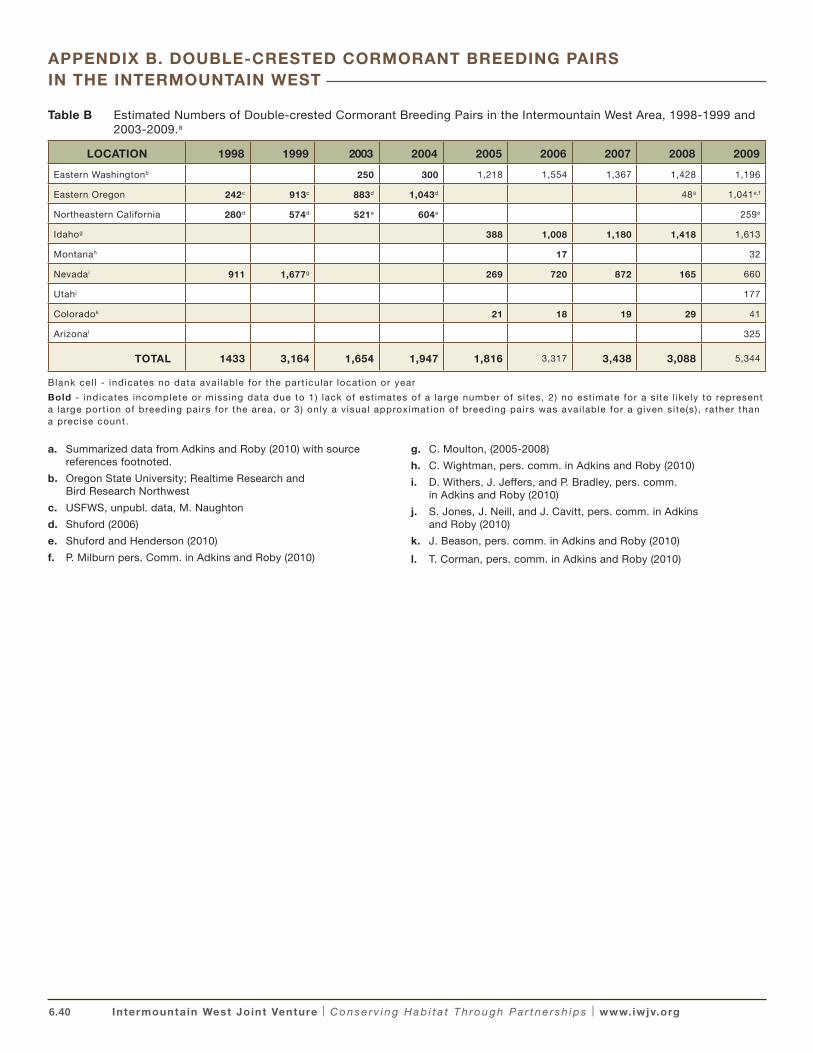
6.40 Intermountain West Joint Venture | C o n s e r v i n g H a b i t a t T h ro u g h P a r t n e r s h i p s | www.iwjv.org
Table B Estimated Numbers of Double-crested Cormorant Breeding Pairs in the Intermountain West Area, 1998-1999 and 2003-2009.a
LOCATION 1998 1999 2003 2004 2005 2006 2007 2008 2009
Eastern Washingtonb 250 300 1,218 1,554 1,367 1,428 1,196
Eastern Oregon 242c 913c 883d 1,043d 48a 1,041e,f
Northeastern California 280d 574d 521e 604e 259e
Idahog 388 1,008 1,180 1,418 1,613
Montanah 17 32
Nevadai 911 1,677g 269 720 872 165 660
Utahj 177
Coloradok 21 18 19 29 41
Arizonal 325
TOTAL 1433 3,164 1,654 1,947 1,816 3,317 3,438 3,088 5,344
Blank cel l - indicates no data avai lable for the part icular locat ion or year
Bold - indicates incomplete or missing data due to 1) lack of est imates of a large number of s i tes, 2) no est imate for a s i te l ikely to represent a large port ion of breeding pairs for the area, or 3) only a v isual approximat ion of breeding pairs was avai lable for a given si te(s) , rather than a precise count.
a. Summarized data from Adkins and Roby (2010) with source references footnoted.
b. Oregon State University; Realtime Research and Bird Research Northwest
c. USFWS, unpubl. data, M. Naughton
d. Shuford (2006)
e. Shuford and Henderson (2010)
f. P. Milburn pers. Comm. in Adkins and Roby (2010)
g. C. Moulton, (2005-2008)
h. C. Wightman, pers. comm. in Adkins and Roby (2010)
i. D. Withers, J. Jeffers, and P. Bradley, pers. comm. in Adkins and Roby (2010)
j. S. Jones, J. Neill, and J. Cavitt, pers. comm. in Adkins and Roby (2010)
k. J. Beason, pers. comm. in Adkins and Roby (2010)
l. T. Corman, pers. comm. in Adkins and Roby (2010)
APPENDIX B. DOUBLE-CRESTED CORMORANT BREEDING PAIRS IN THE INTERMOUNTAIN WEST
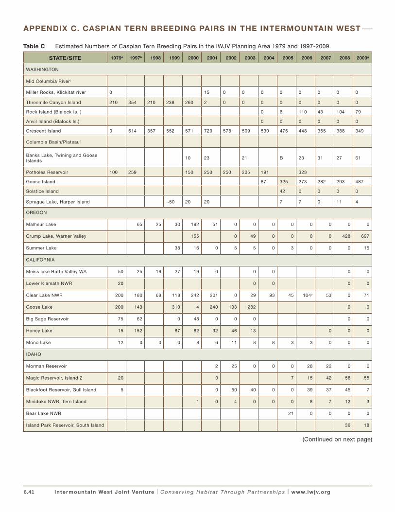
6.41 Intermountain West Joint Venture | C o n s e r v i n g H a b i t a t T h ro u g h P a r t n e r s h i p s | www.iwjv.org
Table C Estimated Numbers of Caspian Tern Breeding Pairs in the IWJV Planning Area 1979 and 1997-2009.
STATE/SITE 1979a 1997b 1998 1999 2000 2001 2002 2003 2004 2005 2006 2007 2008 2009g
WASHINGTON
Mid Columbia Riverc
Miller Rocks, Klickitat river 0 15 0 0 0 0 0 0 0 0
Threemile Canyon Island 210 354 210 238 260 2 0 0 0 0 0 0 0 0
Rock Island (Blalock Is. ) 0 6 110 43 104 79
Anvil Island (Blalock Is.) 0 0 0 0 0 0
Crescent Island 0 614 357 552 571 720 578 509 530 476 448 355 388 349
Columbia Basin/Plateauc
Banks Lake, Twining and Goose Islands
10 23 21 B 23 31 27 61
Potholes Reservoir 100 259 150 250 250 205 191 323
Goose Island 87 325 273 282 293 487
Solstice Island 42 0 0 0 0
Sprague Lake, Harper Island ~50 20 20 7 7 0 11 4
OREGON
Malheur Lake 65 25 30 192 51 0 0 0 0 0 0 0 0
Crump Lake, Warner Valley 155 0 49 0 0 0 0 428 697
Summer Lake 38 16 0 5 5 0 3 0 0 0 15
CALIFORNIA
Meiss lake Butte Valley WA 50 25 16 27 19 0 0 0 0 0
Lower Klamath NWR 20 0 0 0 0
Clear Lake NWR 200 180 68 118 242 201 0 29 93 45 104a 53 0 71
Goose Lake 200 143 310 4 240 133 282 0 0
Big Sage Reservoir 75 62 0 48 0 0 0 0 0
Honey Lake 15 152 87 82 92 46 13 0 0 0
Mono Lake 12 0 0 0 8 6 11 8 8 3 3 0 0 0
IDAHO
Morman Reservoir 2 25 0 0 0 28 22 0 0
Magic Reservoir, Island 2 20 0 7 15 42 58 55
Blackfoot Reservoir, Gull Island 5 0 50 40 0 0 39 37 45 7
Minidoka NWR, Tern Island 1 0 4 0 0 0 8 7 12 3
Bear Lake NWR 21 0 0 0 0
Island Park Reservoir, South Island 36 18
APPENDIX C. CASPIAN TERN BREEDING PAIRS IN THE INTERMOUNTAIN WEST
(Continued on next page)
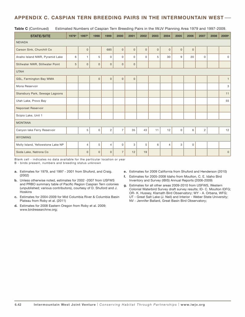
6.42 Intermountain West Joint Venture | C o n s e r v i n g H a b i t a t T h ro u g h P a r t n e r s h i p s | www.iwjv.org
STATE/SITE 1979a 1997b 1998 1999 2000 2001 2002 2003 2004 2005 2006 2007 2008 2009g
NEVADA
Carson Sink, Churchill Co 0 685 0 0 0 0 0 0 0
Anaho Island NWR, Pyramid Lake 6 1 5 0 0 0 0 5 30 9 20 0 0
Stillwater NWR, Stillwater Point 5 0 0 0 0 0
UTAH
GSL, Farmington Bay WMA 0 0 0 0 1
Mona Reservoir 3
Stansbury Park, Sewage Lagoons 11
Utah Lake, Provo Bay 55
Neponset Reservoir
Scipio Lake, Unit 1
MONTANA
Canyon lake Ferry Reservoir 5 0 2 7 35 43 11 12 0 6 2 12
WYOMING
Molly Island, Yellowstone Lake NP 4 5 4 0 3 5 6 4 3 0
Soda Lake, Natrona Co 0 0 0 7 12 19 0
Blank cel l - indicates no data avai lable for the part icular locat ion or year B - birds present, numbers and breeding status unknown
a. Estimates for 1979, and 1997 - 2001 from Shuford, and Craig. (2002)
b. Unless otherwise noted, estimates for 2002 -2007 from USFWS and PRBO summary table of Pacific Region Caspian Tern colonies (unpublished; various contributors), courtesy of D. Shuford and J. Hoskins
c. Estimates for 2004-2009 for Mid Columbia River & Columbia Basin Plateau from Roby et al. (2011)
d. Estimates for 2008 Eastern Oregon from Roby et al. 2009; www.birdresearchnw.org;
e. Estimates for 2009 California from Shuford and Henderson (2010)
f. Estimates for 2005-2008 Idaho from Moulton, C. E. Idaho Bird Inventory and Survey (IBIS) Annual Reports (2006-2009)
g. Estimates for all other areas 2009-2010 from USFWS, Western Colonial Waterbird Survey draft survey results; ID- C. Moulton IDFG; OR- K. Hussey, Klamath Bird Observatory; WY - A. Orbana, WFG; UT - Great Salt Lake (J. Neil) and Interior - Weber State University; NV - Jennifer Ballard, Great Basin Bird Observatory;
APPENDIX C. CASPIAN TERN BREEDING PAIRS IN THE INTERMOUNTAIN WEST
Table C (Continued) Estimated Numbers of Caspian Tern Breeding Pairs in the IWJV Planning Area 1979 and 1997-2009.
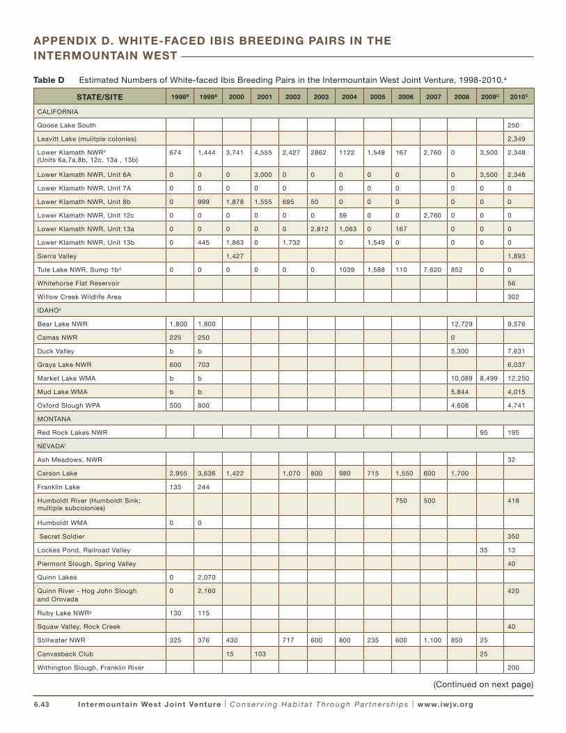
6.43 Intermountain West Joint Venture | C o n s e r v i n g H a b i t a t T h ro u g h P a r t n e r s h i p s | www.iwjv.org
Table D Estimated Numbers of White-faced Ibis Breeding Pairs in the Intermountain West Joint Venture, 1998-2010.a
STATE/SITE 1998B 1999B 2000 2001 2002 2003 2004 2005 2006 2007 2008 2009C 2010C
CALIFORNIA
Goose Lake South 250
Leavitt Lake (mulitple colonies) 2,349
Lower Klamath NWRd
(Units 6a,7a,8b, 12c, 13a , 13b)674 1,444 3,741 4,555 2,427 2862 1122 1,549 167 2,760 0 3,500 2,348
Lower Klamath NWR, Unit 6A 0 0 0 3,000 0 0 0 0 0 0 3,500 2,348
Lower Klamath NWR, Unit 7A 0 0 0 0 0 0 0 0 0 0 0
Lower Klamath NWR, Unit 8b 0 999 1,878 1,555 695 50 0 0 0 0 0 0
Lower Klamath NWR, Unit 12c 0 0 0 0 0 0 59 0 0 2,760 0 0 0
Lower Klamath NWR, Unit 13a 0 0 0 0 0 2,812 1,063 0 167 0 0 0
Lower Klamath NWR, Unit 13b 0 445 1,863 0 1,732 0 1,549 0 0 0 0
Sierra Valley 1,427 1,893
Tule Lake NWR, Sump 1bd 0 0 0 0 0 0 1039 1,588 110 7,620 852 0 0
Whitehorse Flat Reservoir 56
Willow Creek Wildlife Area 302
IDAHOe
Bear Lake NWR 1,800 1,800 12,729 9,576
Camas NWR 225 250 0
Duck Valley b b 5,300 7,631
Grays Lake NWR 600 703 6,037
Market Lake WMA b b 10,089 8,499 12,250
Mud Lake WMA b b 5,844 4,015
Oxford Slough WPA 500 800 4,608 4,741
MONTANA
Red Rock Lakes NWR 95 195
NEVADAf
Ash Meadows, NWR 32
Carson Lake 2,955 3,636 1,422 1,070 800 980 715 1,550 600 1,700
Franklin Lake 135 244
Humboldt River (Humboldt Sink; multiple subcolonies)
750 500 418
Humboldt WMA 0 0
Secret Soldier 350
Lockes Pond, Railroad Valley 35 13
Piermont Slough, Spring Valley 40
Quinn Lakes 0 2,070
Quinn River - Hog John Slough and Orovada
0 2,160 420
Ruby Lake NWRg 130 115
Squaw Valley, Rock Creek 40
Stillwater NWR 325 376 430 717 600 800 235 600 1,100 850 25
Canvasback Club 15 103 25
Withington Slough, Franklin River 200
APPENDIX D. WHITE-FACED IBIS BREEDING PAIRS IN THE INTERMOUNTAIN WEST
(Continued on next page)
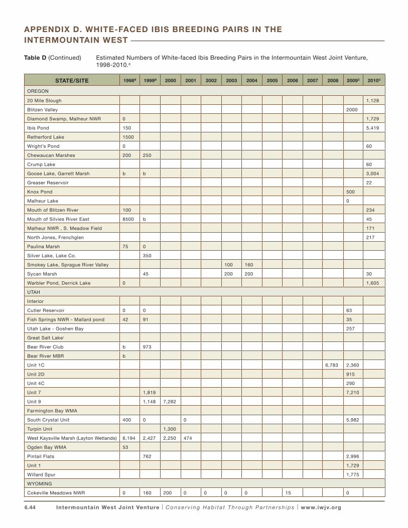
6.44 Intermountain West Joint Venture | C o n s e r v i n g H a b i t a t T h ro u g h P a r t n e r s h i p s | www.iwjv.org
Table D (Continued) Estimated Numbers of White-faced Ibis Breeding Pairs in the Intermountain West Joint Venture, 1998-2010.a
STATE/SITE 1998B 1999B 2000 2001 2002 2003 2004 2005 2006 2007 2008 2009C 2010C
OREGON
20 Mile Slough 1,128
Blitzen Valley 2000
Diamond Swamp, Malheur NWR 0 1,729
Ibis Pond 150 5,419
Retherford Lake 1500
Wright’s Pond 0 60
Chewaucan Marshes 200 250
Crump Lake 60
Goose Lake, Garrett Marsh b b 3,004
Greaser Reservoir 22
Knox Pond 500
Malheur Lake 0
Mouth of Blitzen River 100 234
Mouth of Silvies River East 8500 b 45
Malheur NWR , S. Meadow Field 171
North Jones, Frenchglen 217
Paulina Marsh 75 0
Silver Lake, Lake Co. 350
Smokey Lake, Sprague River Valley 100 160
Sycan Marsh 45 200 200 30
Warbler Pond, Derrick Lake 0 1,605
UTAH
Interior
Cutler Reservoir 0 0 63
Fish Springs NWR - Mallard pond 42 91 35
Utah Lake - Goshen Bay 257
Great Salt Lakej
Bear River Club b 973
Bear River MBR b
Unit 1C 6,783 2,360
Unit 2D 915
Unit 4C 290
Unit 7 1,819 7,210
Unit 9 1,148 7,282
Farmington Bay WMA
South Crystal Unit 400 0 0 5,982
Turpin Unit 1,300
West Kaysville Marsh (Layton Wetlands) 6,194 2,427 2,250 474
Ogden Bay WMA 53
Pintail Flats 762 2,996
Unit 1 1,729
Willard Spur 1,775
WYOMING
Cokeville Meadows NWR 0 160 200 0 0 0 0 15 0
APPENDIX D. WHITE-FACED IBIS BREEDING PAIRS IN THE INTERMOUNTAIN WEST
6.45 Intermountain West Joint Venture | C o n s e r v i n g H a b i t a t T h ro u g h P a r t n e r s h i p s | www.iwjv.org
Blank cel l – no data avai lable
(b) - colony present, numbers of breeding pairs unknown.
a. Colonies with estimates of 25 or more breeding pairs in any year 1998–2010 are reported. Survey methodologies included dawn fly-out counts, nest counts from aerial surveys, and line transects. Each adult observed during dawn fly-out counts and single adults observed on-colony and/or attending a nest are considered representative of one breeding pair. Correction factors for non-breeders and asynchronous nesting are unavailable. Estimates of breeding pairs for individual sites may represent the sum of multiple sub-colonies at that location within a given year.
b. Data for 1998 and 1999 collated in Ivey et al. (2004) unless otherwise noted.
c. Western Colonial Waterbird Survey (WCWS) preliminary results: 2009–2010 courtesy of S. Jones, USFWS Region 6 and J. Hoskins, USFWS Region 1. Primary data sources: Shuford W.D. and R.P. Henderson (2010); PRBO (CA); C. Moulton, IDFG (ID); K. Hussey, Klamath Bird Observatory (OR); J. Ballard, Great Basin Bird Observatory, P. Bradley, NDOW, J. Jeffers, NDOW and (NV); A. Orbana, WFG (WY); C. Wightman, MFWP (MT); J. Neill, (UT - Great Salt Lake Ecosystem Project ); E. Parker, Weber State University, (UT - interior sites). Data for 2000–2008 were compiled by WCWS contributors and presented herein unless otherwise noted.
d. Data for 1998 and 1999 from Lower Klamath NWR files, courtesy of J. Beckstrand in Ivey et al. (2004); 2003 and 2004 Lower Klamath NWR data from Shuford et al (2006). All other years from Klamath NWR Annual Narrative Reports.
e. 1998 and 1999 data for Bear Lake NWR from R. Sjostrom, pers comm and Camas NWR from NWR narrative reports in Ivey et al. (2004); Idaho colony data 2005–2009 from IDFG Idaho Bird Inventory and Survey Annual Reports, Moulton and Sallabanks (2006); Moulton (2007, 2008, 2009, 2010).
f. Data for Nevada 1998–2008 provided by J. Jeffers, NDOW and collated electronically courtesy of J. Hoskins, USFWS. Primary data sources: L. Neil, NDOW, P. Bradley NDOW
g. Data for 1998 and 1999 from J. Mackey, Ruby Lake NWR in Ivey et al. (2004).
h. 1998 and 1999 data from Malheur NWR files, in Ivey et al. (2004).
i. 1998 and 1999 data for Lake County, OR sites from ODFW data files, in Ivey et al. (2004).
j. Great Salt Lake 1998–2001 colony data from Paul et al (2000a,b), Paul et al (2001).
k. Data from Gary Ivey and Chris Carey, Oregon Department of Fish and Wildlife, unpublished data..
APPENDIX D. WHITE-FACED IBIS BREEDING PAIRS IN THE INTERMOUNTAIN WEST
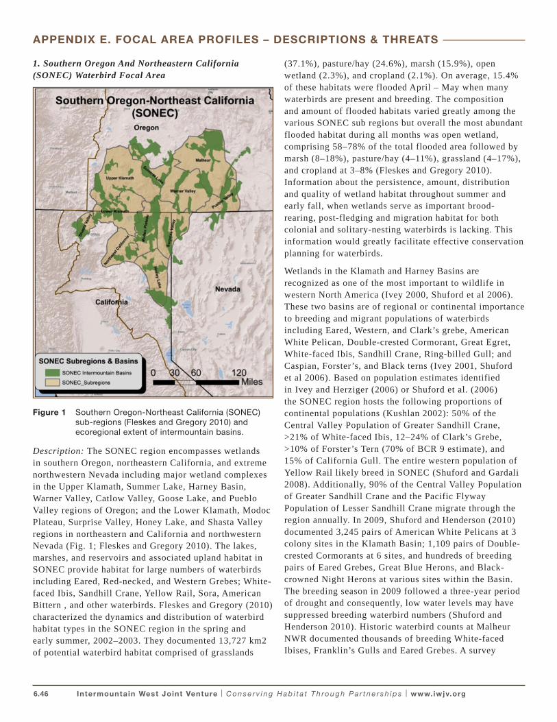
6.46 Intermountain West Joint Venture | C o n s e r v i n g H a b i t a t T h ro u g h P a r t n e r s h i p s | www.iwjv.org
1. Southern Oregon And Northeastern California (SONEC) Waterbird Focal Area
Figure 1 Southern Oregon-Northeast California (SONEC) sub-regions (Fleskes and Gregory 2010) and ecoregional extent of intermountain basins.
Description: The SONEC region encompasses wetlands in southern Oregon, northeastern California, and extreme northwestern Nevada including major wetland complexes in the Upper Klamath, Summer Lake, Harney Basin, Warner Valley, Catlow Valley, Goose Lake, and Pueblo Valley regions of Oregon; and the Lower Klamath, Modoc Plateau, Surprise Valley, Honey Lake, and Shasta Valley regions in northeastern and California and northwestern Nevada (Fig. 1; Fleskes and Gregory 2010). The lakes, marshes, and reservoirs and associated upland habitat in SONEC provide habitat for large numbers of waterbirds including Eared, Red-necked, and Western Grebes; White-faced Ibis, Sandhill Crane, Yellow Rail, Sora, American Bittern , and other waterbirds. Fleskes and Gregory (2010) characterized the dynamics and distribution of waterbird habitat types in the SONEC region in the spring and early summer, 2002–2003. They documented 13,727 km2 of potential waterbird habitat comprised of grasslands
(37.1%), pasture/hay (24.6%), marsh (15.9%), open wetland (2.3%), and cropland (2.1%). On average, 15.4% of these habitats were flooded April – May when many waterbirds are present and breeding. The composition and amount of flooded habitats varied greatly among the various SONEC sub regions but overall the most abundant flooded habitat during all months was open wetland, comprising 58–78% of the total flooded area followed by marsh (8–18%), pasture/hay (4–11%), grassland (4–17%), and cropland at 3–8% (Fleskes and Gregory 2010). Information about the persistence, amount, distribution and quality of wetland habitat throughout summer and early fall, when wetlands serve as important brood-rearing, post-fledging and migration habitat for both colonial and solitary-nesting waterbirds is lacking. This information would greatly facilitate effective conservation planning for waterbirds.
Wetlands in the Klamath and Harney Basins are recognized as one of the most important to wildlife in western North America (Ivey 2000, Shuford et al 2006). These two basins are of regional or continental importance to breeding and migrant populations of waterbirds including Eared, Western, and Clark’s grebe, American White Pelican, Double-crested Cormorant, Great Egret, White-faced Ibis, Sandhill Crane, Ring-billed Gull; and Caspian, Forster’s, and Black terns (Ivey 2001, Shuford et al 2006). Based on population estimates identified in Ivey and Herziger (2006) or Shuford et al. (2006) the SONEC region hosts the following proportions of continental populations (Kushlan 2002): 50% of the Central Valley Population of Greater Sandhill Crane, >21% of White-faced Ibis, 12–24% of Clark’s Grebe, >10% of Forster’s Tern (70% of BCR 9 estimate), and 15% of California Gull. The entire western population of Yellow Rail likely breed in SONEC (Shuford and Gardali 2008). Additionally, 90% of the Central Valley Population of Greater Sandhill Crane and the Pacific Flyway Population of Lesser Sandhill Crane migrate through the region annually. In 2009, Shuford and Henderson (2010) documented 3,245 pairs of American White Pelicans at 3 colony sites in the Klamath Basin; 1,109 pairs of Double-crested Cormorants at 6 sites, and hundreds of breeding pairs of Eared Grebes, Great Blue Herons, and Black-crowned Night Herons at various sites within the Basin. The breeding season in 2009 followed a three-year period of drought and consequently, low water levels may have suppressed breeding waterbird numbers (Shuford and Henderson 2010). Historic waterbird counts at Malheur NWR documented thousands of breeding White-faced Ibises, Franklin’s Gulls and Eared Grebes. A survey
APPENDIX E. FOCAL AREA PROFILES – DESCRIPTIONS & THREATS
6.47 Intermountain West Joint Venture | C o n s e r v i n g H a b i t a t T h ro u g h P a r t n e r s h i p s | www.iwjv.orgIntermountain West Joint Venture | C o n s e r v i n g H a b i t a t T h ro u g h P a r t n e r s h i p s | www.iwjv.org
APPENDIX E. FOCAL AREA PROFILES – DESCRIPTIONS & THREATS
in 2009 found 2,500 pairs of ibises and 300 pairs of Franklin’s Gulls (G. Ivey, unpublished data). Malheur also supports high numbers of breeding Sandhill Cranes, with 245 pairs recorded in 1999 (Ivey and Herziger 2000).
Threats: Threats to waterbirds in the SONEC region include wetland loss, conversion of upland habitats to uses unsuitable for waterbirds, changes in irrigation practices, degraded water quality, contamination, and negative effects of common carp on waterbird food resources, particularly in the Harney Basin (Ivey et al. 1998, Ivey 2000). These threats are well documented, and perhaps are most extreme in the Klamath Basin. The Klamath River Basin encompasses over 9.8 million acres. Akins (1970) estimated there were originally 142,000 ha of wetlands in the upper basin alone. In 1905, the Bureau of Reclamation (BOR) initiated the draining and the reclamation of lakebeds for agricultural, water storage, and flood control purposes. Lower Klamath Lake, Upper Klamath Lake, Tule Lake and the Klamath River were all manipulated for BOR water use purposes. Today, less than 25% of historic wetlands remain (NRCS 2006), and only a portion of those areas hold water into the fall (Ivey 2001). Of this remaining wetland acreage, about 17,400 acres of naturally occurring historic wetlands are protected by state and Federal agencies and an additional 18,200 wetland acres have been restored or are currently under restoration (NRCS 2006). Wetlands managed for migratory birds are maintained largely via drain water deemed surplus to agricultural needs.
Today, lack of secure water rights for wetlands and streams is the most critical threat to waterbirds in the Klamath Basin (Ivey 2001). Although all of the remaining wetlands are individually and collectively important to waterbirds, Clear Lake, Klamath Marsh, Lower Klamath, and Tule Lake NWRs; Sycan Marsh and Upper Klamath Lake are particularly significant to waterbirds (Shuford 2006). Many of these areas are dependent on the BOR Klamath Project for water. The Project does not have a fish or wildlife purpose, thus placing NWRs last in priority for water. Recent ESA listings of Lost
River (Deltistes luxatus) and shortnose (Chasmistes brevirostris) suckers in Upper Klamath Lake and Coho salmon in the Klamath River, coupled with existing demand for agricultural irrigation water, have led to significant shortages of water available to refuges. Recent drought conditions have exacerbated pre-existing water shortages. Ongoing and predicted declines in snowpack resulting from climate change may further impact habitat management opportunities for waterbirds, particularly in the late summer and fall.
The proposed Klamath Basin Restoration Agreement is intended to settle many of the aquatic resource issues in the Klamath Basin, including providing adequate water for refuges. As of this writing, this agreement has not been implemented and remains uncertain (Shuford 2010). Additionally, the FWS has filed water rights claims for Tule Lake and Lower Klamath NWRs in the Oregon water rights adjudication process. Resolution of the Klamath Basin adjudication is likely several decades in the future.
Flood-irrigated agricultural lands in the SONEC region provide important foraging habitat for many waterbirds. Not including refuge lands, there were about 499,990 acres of agricultural land under irrigation in the upper Klamath Basin in 2007 with roughly 190,000 acres of this total included in the BOR Klamath Project (Gannet et al 2007). The proportion of waterbirds that use agricultural fields versus wetlands is unknown, but irrigated fields clearly add to the diversity of habitats available to waterbirds and likely boost the carrying capacity of the area for some species (Shuford 2006). Flood irrigation is increasingly being challenged because of the relatively large quantities of water required. Many ranchers and farmers are attempting to increase the efficiency of water use through conversions to sprinklers and land leveling. Although this reduces water consumption, it also reduces the area and diversity of surface water available to waterbirds (D. Mauser pers comm). The trend toward increasing use of sprinkler irrigation and reduction in flood irrigation practices (Kenny et. al., 2009) will result in the loss of foraging habitat for a wide range of waterbirds.
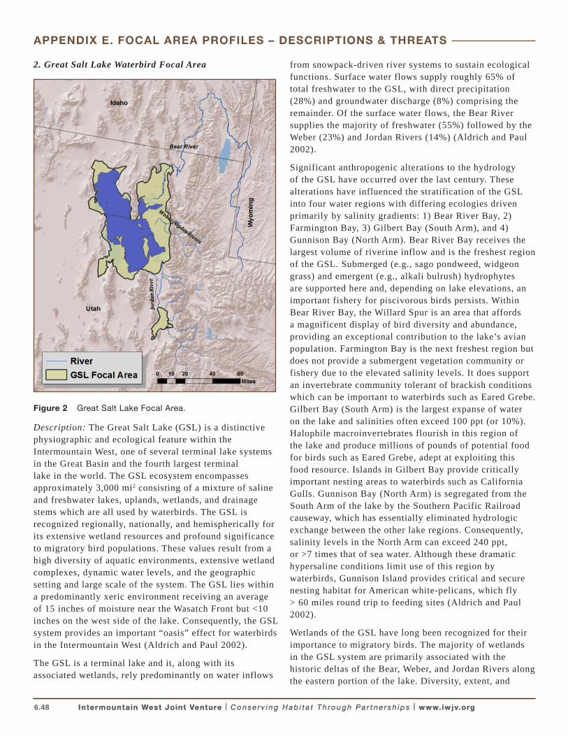
6.48 Intermountain West Joint Venture | C o n s e r v i n g H a b i t a t T h ro u g h P a r t n e r s h i p s | www.iwjv.orgIntermountain West Joint Venture | C o n s e r v i n g H a b i t a t T h ro u g h P a r t n e r s h i p s | www.iwjv.org
APPENDIX E. FOCAL AREA PROFILES – DESCRIPTIONS & THREATS
2. Great Salt Lake Waterbird Focal Area
Figure 2 Great Salt Lake Focal Area.
Description: The Great Salt Lake (GSL) is a distinctive physiographic and ecological feature within the Intermountain West, one of several terminal lake systems in the Great Basin and the fourth largest terminal lake in the world. The GSL ecosystem encompasses approximately 3,000 mi2 consisting of a mixture of saline and freshwater lakes, uplands, wetlands, and drainage stems which are all used by waterbirds. The GSL is recognized regionally, nationally, and hemispherically for its extensive wetland resources and profound significance to migratory bird populations. These values result from a high diversity of aquatic environments, extensive wetland complexes, dynamic water levels, and the geographic setting and large scale of the system. The GSL lies within a predominantly xeric environment receiving an average of 15 inches of moisture near the Wasatch Front but <10 inches on the west side of the lake. Consequently, the GSL system provides an important “oasis” effect for waterbirds in the Intermountain West (Aldrich and Paul 2002).
The GSL is a terminal lake and it, along with its associated wetlands, rely predominantly on water inflows
from snowpack-driven river systems to sustain ecological functions. Surface water flows supply roughly 65% of total freshwater to the GSL, with direct precipitation (28%) and groundwater discharge (8%) comprising the remainder. Of the surface water flows, the Bear River supplies the majority of freshwater (55%) followed by the Weber (23%) and Jordan Rivers (14%) (Aldrich and Paul 2002).
Significant anthropogenic alterations to the hydrology of the GSL have occurred over the last century. These alterations have influenced the stratification of the GSL into four water regions with differing ecologies driven primarily by salinity gradients: 1) Bear River Bay, 2) Farmington Bay, 3) Gilbert Bay (South Arm), and 4) Gunnison Bay (North Arm). Bear River Bay receives the largest volume of riverine inflow and is the freshest region of the GSL. Submerged (e.g., sago pondweed, widgeon grass) and emergent (e.g., alkali bulrush) hydrophytes are supported here and, depending on lake elevations, an important fishery for piscivorous birds persists. Within Bear River Bay, the Willard Spur is an area that affords a magnificent display of bird diversity and abundance, providing an exceptional contribution to the lake’s avian population. Farmington Bay is the next freshest region but does not provide a submergent vegetation community or fishery due to the elevated salinity levels. It does support an invertebrate community tolerant of brackish conditions which can be important to waterbirds such as Eared Grebe. Gilbert Bay (South Arm) is the largest expanse of water on the lake and salinities often exceed 100 ppt (or 10%). Halophile macroinvertebrates flourish in this region of the lake and produce millions of pounds of potential food for birds such as Eared Grebe, adept at exploiting this food resource. Islands in Gilbert Bay provide critically important nesting areas to waterbirds such as California Gulls. Gunnison Bay (North Arm) is segregated from the South Arm of the lake by the Southern Pacific Railroad causeway, which has essentially eliminated hydrologic exchange between the other lake regions. Consequently, salinity levels in the North Arm can exceed 240 ppt, or >7 times that of sea water. Although these dramatic hypersaline conditions limit use of this region by waterbirds, Gunnison Island provides critical and secure nesting habitat for American white-pelicans, which fly > 60 miles round trip to feeding sites (Aldrich and Paul 2002).
Wetlands of the GSL have long been recognized for their importance to migratory birds. The majority of wetlands in the GSL system are primarily associated with the historic deltas of the Bear, Weber, and Jordan Rivers along the eastern portion of the lake. Diversity, extent, and
6.49 Intermountain West Joint Venture | C o n s e r v i n g H a b i t a t T h ro u g h P a r t n e r s h i p s | www.iwjv.orgIntermountain West Joint Venture | C o n s e r v i n g H a b i t a t T h ro u g h P a r t n e r s h i p s | www.iwjv.org
APPENDIX E. FOCAL AREA PROFILES – DESCRIPTIONS & THREATS
abundance are driven primarily by availability of fresh water and surface elevation of the GSL. Surface elevations of GSL are extremely dynamic in response to long-term precipitation cycles as well as seasonal variability in evapotranspiration and inflow rates. Both of these factors play important roles in the ecology and productivity of wetlands. For example, dramatic increases in GSL lake levels occurred in the mid-1980s due to significant increases in multi-year regional precipitation rates. This resulted in the GSL inundating approximately 80% of wetlands in the system and killing essentially all wetland vegetation through increased salinity. Although the GSL began to recede in the late 1980s it has taken nearly two decades for the wetland resources to approach the extent and diversity observed prior to the 1980s (Aldrich and Paul 2002). Conversely, sustained drought conditions in the early 2000s resulted in the some of the lowest lake elevations on record and dramatic reductions in available wetland habitat, up to 75% in some management complexes (Olson 2009, Downard 2010). Seasonally, GSL levels change in response to evapotranspiration and inflow rates which produce san annual high during May–July and a low during October–November. Consequently, winter and spring increases in lake levels can inundate tens of thousands of acres in most years and hundreds of thousands of acres in exceptionally wet years (Aldrich and Paul 2002). Although this variability creates challenges for natural resource managers and planners, it is an important driver in the long-term productivity of these wetland resources.
The significant presence of private, state, and federally managed wetland complexes is testament to the profound wetland and avian resources at GSL. Sportsman’s groups began forming hunting clubs in the 1890s to protect waterfowl habitat, and up to 50,000 acres are incorporated into hunting clubs around the GSL today. During the 1920s and 1930s the state developed several waterfowl management areas around the GSL including Public Shootings Grounds, Ogden Bay, Farmington Bay, and Locomotive Springs. The Utah Division of Wildlife Resources currently manages eight Waterfowl Management Areas consisting of approximately 80,000 acres around the margins of GSL. Included in these are Gunnison and Hat Islands within the GSL, acquired by UDWR to protect nesting waterbird colonies (Aldrich and Paul 2002). Bear River Migratory Bird Refuge was established in 1929 on the historic delta of the Bear River in response to substantial losses in wetlands from irrigation diversions and to dramatic losses of waterfowl to botulism observed in that decade. Today BRMBR encompasses approximately 75,000 acres. Other
significant areas are managed by NGOs (>3,000 acres) including The Nature Conservancy and National Audubon Society or entities such as Kennecott Utah Copper’s Inland Sea Shorebird Reserve (3,800 acres). The dynamic mosaic of lake, managed and unmanaged wetland habitats, and associated uplands results in the GSL supporting one of the most diverse and abundant waterbird populations in the Intermountain West. Publicly and privately managed wetland complexes are paramount to meeting the biological needs of a diverse group of waterbirds here.
The GSL system is host to 16 species of colonial nesting waterbirds, some representing the largest single populations known to occur in the world and others a significant proportion of the Pacific Flyway. Some notable examples include Eared Grebe, California gull, American White-Pelican, and White-faced Ibis. Eared Grebes occur at the GSL during all seasons except mid-winter, bur the primary significance of the GSL for this species occurs during migration. Approximately half of the known continental population of eared grebes stages at the GSL during fall migration. Where they undergo a critical molt event and are rendered flightless for 35–40 days. During this time they forage extensively on an abundant supply of halophile invertebrates, primarily brine shrimp. Consequently, the GSL and its halophile invertebrate population is of continental significance to the conservation of this species (Belovsky et al. 2011).
Although several species of gulls (Franklin’s, Ring-billed, and California) breed in the GSL system, the California Gull population at GSL is the largest in the world, comprising approximately 34% of the continental population. Post-breeding estimates of Franklin’s Gull at GSL may comprise as much as 27% of the continental population. California Gull populations at GSL have more than tripled since the early 1980s. This population growth is attributed primarily to a combination of highly available natural and human food resources within close proximity to anthropogenically enhanced nest sites such as dikes and levees at wildlife management areas, solar evaporation ponds, and sewage lagoons.
The GSL also supports a significant portion of the continental population of American White Pelicans. During the GSL Waterbird Survey coordinated by the Utah Division of Wildlife Resources, over 85,000 individuals were counted during one 10-day survey period in September of 1997 (Paul and Manning 2002). Gunnison Island serves as one of the largest breeding colonies in North America with its highest recorded breeding population exceeding 20,000. This peak represents about 16% of the continent-wide total. Currently, Gunnison
6.50 Intermountain West Joint Venture | C o n s e r v i n g H a b i t a t T h ro u g h P a r t n e r s h i p s | www.iwjv.orgIntermountain West Joint Venture | C o n s e r v i n g H a b i t a t T h ro u g h P a r t n e r s h i p s | www.iwjv.org
APPENDIX E. FOCAL AREA PROFILES – DESCRIPTIONS & THREATS
Island is the only continental colony to show an increasing population over the past three decades (Neill et al. 2009). Size and viability of this colony is largely a reflection of the greater GSL ecosystem, especially shallow-water, carp-dominated fisheries. Before carp and other non-native fishes such as gizzard shad were inmtroduced, small native chubs and shiners were found in the system and supported historic populations of pelicans but likely not to the extent the large freshwater impoundments on management areas support today (Aldrich and Paul 2002).
The GSL hosts more than 30,000 nesting White-faced Ibis, on average, and until recently harbored the largest breeding population in North America. Hence, the GSL supports at least 25% of the continental population, with peak estimates approaching 40% (Paul and Manning 2008). These birds typically select emergent marshes, often keying in on hardstem bulrush or robust alkali bulrush as nesting sites. They nest in colonies that can vary dramatically in size and are frequently associated with other colonial nesting waterbirds such as Franklin’s Gull, Black-crowned Night Heron, Forster’s Tern, and Snowy Egret. White-faced Ibis exhibit a nomadic and opportunistic nesting behavior within the GSL system and between other Great Basin wetland sites due to the variability in the amount and distribution of their preferred nesting habitat. For example, when the GSL flooded the adjacent marsh complexes in the mid-1980s White-faced Ibis populations were substantially reduced in the GSL but other sites such as Cache Valley in the Bear River Watershed and other sites throughout the Great Basin such as the Carson/Lahontan complex in NV, Malheur Lake in Oregon, and wetland complexes in the Upper Snake River of Idaho experienced increases in available nesting habitat and breeding ibis (Aldrich and Paul 2002).
Threats: The single greatest threat to the aquatic and wetland habitats that waterbirds rely upon in the GSL system is, and will continue to be, the availability of freshwater supplies. This threat emanates from two primary sources: 1) anthropogenic changes in water use and distribution, and 2) long-term shifts in climatic patterns. The GSL lies immediately adjacent to one of the largest metropolitan areas in the Intermountain West. More than 70% of Utah’s population (2.5 million) lives along the Wasatch Front and within the GSL watershed; this population has more than tripled since the 1950s. Current growth estimates project this population will nearly double by 2050, exceeding national and global human population growth rate projections. Some studies suggest current population levels in Utah have already
exceeded many renewable natural resource supplies (Utah Population and Environment Coalition 2007). Increased demands and pressures on freshwater resources are inevitable to accommodate future human growth. For example, although many water users on the Bear River believe the system is fully allocated, the UDWR has been directed to develop an additional 275,000 acre feet of water from the Bear River to support this rapid population growth (Downard 2010). This development equates to >60% of the current annual water allocation to Bear River Migratory Bird Refuge. Over the past decade BRMBR has consistently experienced a deficit in water allocation between July and September (Downard 2010). Further water developments in the Bear River may compromise the refuges ability to meet wetland management objectives. The myriad of saline lake systems around the world whose ecological integrity has been significantly compromised, or has collapsed, due to redistribution of water resources provides poignant examples of the challenges GSL natural resource managers face (Williams 2002).
Shifts in climatic patterns will undoubtedly impact human water use patterns and wetland resources in the GSL system. Current stresses on the GSL ecosystem may be exacerbated by the influences of climate change: models for the Intermountain West predict a warmer climate and a shift in precipitation patterns to wetter winters and drier summers (Reichler 2009). Reductions in water equivalent snowpack, an earlier peak snowpack, and an earlier snowmelt in the GSL watershed have already been documented (Bedford and Douglas 2008). Earlier spring runoff, reduced spring flows, and a greater human demand for water in the summer will likely influence the amount, location, and value of habitats for waterbirds and all wetland dependent wildlife that rely on the GSL system.
Although the availability of water is of primary concern by natural resource managers, the quality of water resources is also of significant concern. Because the GSL and associated wetlands lie at the terminus of the watershed with no outlets and is closely associated with major industrial and metropolitan areas, the accumulation of a multitude of environmental contaminants is of concern. High concentrations of several contaminants (e.g., mercury, selenium, PCBs) have been identified in aquatic resources and wildlife within the GSL system (Wingert 2008, Naftz et al. 2008; Vest et al. 2009; Conover and Vest 2009a,b). Investigations are currently underway to more fully understand the potential impacts to waterbirds.
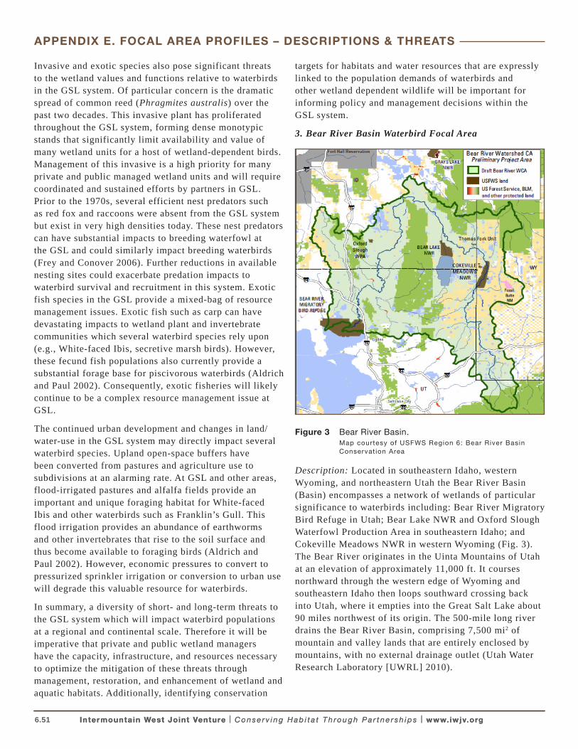
6.51 Intermountain West Joint Venture | C o n s e r v i n g H a b i t a t T h ro u g h P a r t n e r s h i p s | www.iwjv.orgIntermountain West Joint Venture | C o n s e r v i n g H a b i t a t T h ro u g h P a r t n e r s h i p s | www.iwjv.org
APPENDIX E. FOCAL AREA PROFILES – DESCRIPTIONS & THREATS
Invasive and exotic species also pose significant threats to the wetland values and functions relative to waterbirds in the GSL system. Of particular concern is the dramatic spread of common reed (Phragmites australis) over the past two decades. This invasive plant has proliferated throughout the GSL system, forming dense monotypic stands that significantly limit availability and value of many wetland units for a host of wetland-dependent birds. Management of this invasive is a high priority for many private and public managed wetland units and will require coordinated and sustained efforts by partners in GSL. Prior to the 1970s, several efficient nest predators such as red fox and raccoons were absent from the GSL system but exist in very high densities today. These nest predators can have substantial impacts to breeding waterfowl at the GSL and could similarly impact breeding waterbirds (Frey and Conover 2006). Further reductions in available nesting sites could exacerbate predation impacts to waterbird survival and recruitment in this system. Exotic fish species in the GSL provide a mixed-bag of resource management issues. Exotic fish such as carp can have devastating impacts to wetland plant and invertebrate communities which several waterbird species rely upon (e.g., White-faced Ibis, secretive marsh birds). However, these fecund fish populations also currently provide a substantial forage base for piscivorous waterbirds (Aldrich and Paul 2002). Consequently, exotic fisheries will likely continue to be a complex resource management issue at GSL.
The continued urban development and changes in land/water-use in the GSL system may directly impact several waterbird species. Upland open-space buffers have been converted from pastures and agriculture use to subdivisions at an alarming rate. At GSL and other areas, flood-irrigated pastures and alfalfa fields provide an important and unique foraging habitat for White-faced Ibis and other waterbirds such as Franklin’s Gull. This flood irrigation provides an abundance of earthworms and other invertebrates that rise to the soil surface and thus become available to foraging birds (Aldrich and Paul 2002). However, economic pressures to convert to pressurized sprinkler irrigation or conversion to urban use will degrade this valuable resource for waterbirds.
In summary, a diversity of short- and long-term threats to the GSL system which will impact waterbird populations at a regional and continental scale. Therefore it will be imperative that private and public wetland managers have the capacity, infrastructure, and resources necessary to optimize the mitigation of these threats through management, restoration, and enhancement of wetland and aquatic habitats. Additionally, identifying conservation
targets for habitats and water resources that are expressly linked to the population demands of waterbirds and other wetland dependent wildlife will be important for informing policy and management decisions within the GSL system.
3. Bear River Basin Waterbird Focal Area
Figure 3 Bear River Basin. Map courtesy of USFWS Region 6: Bear River Basin
Conservat ion Area
Description: Located in southeastern Idaho, western Wyoming, and northeastern Utah the Bear River Basin (Basin) encompasses a network of wetlands of particular significance to waterbirds including: Bear River Migratory Bird Refuge in Utah; Bear Lake NWR and Oxford Slough Waterfowl Production Area in southeastern Idaho; and Cokeville Meadows NWR in western Wyoming (Fig. 3). The Bear River originates in the Uinta Mountains of Utah at an elevation of approximately 11,000 ft. It courses northward through the western edge of Wyoming and southeastern Idaho then loops southward crossing back into Utah, where it empties into the Great Salt Lake about 90 miles northwest of its origin. The 500-mile long river drains the Bear River Basin, comprising 7,500 mi2 of mountain and valley lands that are entirely enclosed by mountains, with no external drainage outlet (Utah Water Research Laboratory [UWRL] 2010).

6.52 Intermountain West Joint Venture | C o n s e r v i n g H a b i t a t T h ro u g h P a r t n e r s h i p s | www.iwjv.orgIntermountain West Joint Venture | C o n s e r v i n g H a b i t a t T h ro u g h P a r t n e r s h i p s | www.iwjv.org
APPENDIX E. FOCAL AREA PROFILES – DESCRIPTIONS & THREATS
Annual precipitation in the Basin ranges from about 9–60 inches reflecting highly variable conditions among arable valleys and surrounding mountain ranges. Mean annual precipitation is 8 inches with most of this received as winter snowfall in the high elevation forests (UWRL 2010, Downard 2010). The landscape is predominantly dry with about 60% of the area in arid-land shrub, grass, and herbaceous cover types. Open water and emergent wetlands comprise about 4.5% of the Basin; rangeland and agriculture account for the majority (78.3%) of land use (UWRL 2010). The lower reaches of the river are used extensively for irrigation in the farming valleys of southeastern Idaho and northern Utah. The Bear River is the largest tributary to the Great Salt Lake and the lower 10 miles near its delta are protected as part of the Bear River Migratory Bird Refuge.
Bear River Migratory Bird Refuge (BRMBR): BRMBR lies within the Great Salt Lake (GSL) basin and is considered part of the GSL focal area. However, because of BRMBRs reliance on the Bear River and association with the Bear River Basin Conservation Area a description of its value to the avian resources of the Bear River Basin is warranted here. Established in 1928 and encompassing approximately 74,000 acres, the BRMBR is the oldest refuge located along the Bear River. It encompasses more than 41,000 acres of freshwater marsh and open water habitats that are managed in a series of 25 impoundments for the benefit of migratory birds (Olson et al 2004). BRMBR marshes are the largest freshwater component of the Great Salt Lake ecosystem. The unique location, juxtaposition of wetlands within an arid landscape, and abundance of aquatic food resources on this refuge provide critical nesting, feeding and migratory stop-over habitat for waterbirds in both the Pacific and Central Flyways. Breeding White-faced Ibis, Franklin’s Gull and Black Tern; and foraging American White Pelican are priority species for management on BRMBR lands (Olson et al 2004).
From 1956 to 2002 Olson et al (2004) estimated an average of 5,286 pairs of White-faced Ibis on the BRMBR. In 2009 J. Neill (pers com) estimated about 10,775 pairs of ibis, 7,000 pairs of Franklin’s Gull, 1,900 pairs of Eared Grebe, and lesser numbers of Black-crowned Night Heron, and Cattle Egrets nesting on refuge lands in Bear River Bay. The BRMBR also serves as an important feeding area for American White Pelicans that breed at Great Salt Lake.
Threats: Water availability and security are significant threats to waterbird habitat at the BRMBR, in part due to the location of the refuge at the downstream end of the
Bear River. Multiple threats to Refuge water supply and security include water loss from upstream withdrawals for agricultural, municipal and industrial users and events related to climate change including low snowpack levels, and annual drought and flood conditions (Downard 2010). The refuge intensively manages a large and complex system of dikes and canals to impound freshwater and exclude salt water to benefit waterbirds, waterfowl, and shorebirds. But even with aggressive management, up to 75% of wetland units dry up due to low summer flows. The population of Box Elder County, Utah where BRMBR is located increased by 17% between 2000 and 2010 (U.S. Census Bureau, 2011). This growth represents increasing competition for land and water resources in a region already experiencing water shortfalls from drought and escalating water use.
During the irrigation season (May 1-September 30), the water in the Bear River flowing into the Refuge consists mainly of irrigation return flows, and pollution from agricultural pesticides and toxins is an ongoing concern. Following historic floods of the 1980’s, a non-native invasive subspecies of common reed (Phragmites australis) spread rapidly into the BRMBR. This continuing threat was addressed with a specific management plan for invasive species control but it will be many years before this threat is abated (Olson 2007).
Bear Lake NWR: Bear Lake is a 1,090 mi2 natural freshwater lake that straddles the border of Idaho and Utah at an elevation of nearly 6,000 ft. The Refuge lies at the northern tip of Bear Lake and encompasses the Mud Lake wetland complex. Spring runoff water from the Bear River is diverted into Mud Lake which serves as a filter before the water is released into Bear Lake and stored for future agricultural use (Downard 2010). The refuge is managed as system of dikes and marsh management units comprising 18,000 acres of hardstem bulrush, cattail, and open water habitat with nesting islands and surrounding wet meadows (National Audubon Society 2011, UWRL 2011). The Refuge also cultivates nearby fields to provide food crops of barley and alfalfa for Sandhill Cranes and other waterbirds.
Bear Lake NWR has become increasingly important to breeding White-faced Ibis in recent years supporting 12,729 pairs in 2008 and 9576 in 2010, likely the largest colony in the west (Moulton 2009; M. Moulton, pers com). These numbers far exceed those documented by Bear Lake NWR staff 1985-1999 when ibis colonies averaged 1,645 nesting pairs (Earnst et al 1998). In 2008 and 2010 an estimated 29,326 and 11,750 pairs of Franklin’s Gulls nested on Bear Lake NWR (Moulton 2009, Moulton pers
6.53 Intermountain West Joint Venture | C o n s e r v i n g H a b i t a t T h ro u g h P a r t n e r s h i p s | www.iwjv.orgIntermountain West Joint Venture | C o n s e r v i n g H a b i t a t T h ro u g h P a r t n e r s h i p s | www.iwjv.org
APPENDIX E. FOCAL AREA PROFILES – DESCRIPTIONS & THREATS
com) again far surpassing numbers documented in the early 1990’s (Trost and Gerstell 1994). Other breeding waterbirds include Sandhill Crane, Great Blue Heron, Snowy Egret; Caspian and Black terns; and Western, Clarks’ and Eared Grebes. This wetland complex also may contain the densest breeding population of American Bitterns in Idaho (NAS 2011). Bear Lake NWR is an important fall staging area for Greater Sandhill Cranes, generally supporting 300–500 individuals.
Threats: Water for wetland management at the BRNWR is relatively secure because flows from the Bear River are diverted through the NWR before entering Bear Lake for later agricultural uses and the Bear River Compact requires no net loss of water into Bear Lake from any future upstream developments (Downard 2010). Threats to water supplies at this site stem from climate change and the possibility of significant reductions in snowpack which could severely diminish water supply to wetlands in the Bear River Basin.
Concerns for water quality focus largely on levels of phosphorous, pesticides, and sediments (NAS 2011). Muddy water from carp feeding and silt from the Bear River have reduced water quality, resulting in a decline in wildlife use (Downard 2010, NAS 2011). Management of introduced carp and noxious weeds is ongoing, and diking and strategic timing of water intake are measures implemented to reduce the influx of nutrients and sediments into refuge wetlands (NAS 2011).
Between 2006 and 2010, approximately 5,100 acres of agricultural lands were converted from flood to sprinkler irrigation in the four counties in Idaho encompassed partially or entirely within the Bear River Basin (Bear Lake, Franklin, Bannock, and Caribou Counties). Flood irrigated agricultural lands surrounding colonial waterbird nesting sites serve as important foraging areas (Trost and Gerstell 1984; Ivey and Herziger 2006; Bray and Klebenow 1988). Conversion from flood to sprinkler irrigation in the surrounding landscape may reduce the forage base for breeding and migrating waterbirds in southeastern Idaho.
Oxford Slough Waterfowl Production Area (WPA): This 18,800 acre site is a deep, hardstem bulrush marsh, interspersed with open water and surrounded by areas of playa, saltgrass flats, native wet meadow, and some cropland (IDFG 2005). The WPA provides valuable
foraging habitat for Sandhill Cranes, Franklin’s Gulls, and White-faced Ibis (IDFG 2005; NAS 2011). Meadows are hayed to provide short grass for waterbird feeding areas along with managed alfalfa and grain fields. The marsh is allowed to fluctuate naturally and may dry out in drought years. Moulton (pers com) documented about 4,740 pairs of White-faced Ibis and 6,860 pairs of Franklins Gulls in breeding colonies at Oxford Slough WPA in 2010. These numbers far exceed those documented in the mid-1980s and mid-1990s when ibis colonies were documented at about 500 to 1,050 pairs (Earnst et al 1998). About 300-400 Sandhill Cranes use this area to feed and rest during fall migration.
Threats: Other than some concern for introduced noxious weeds, few apparent threats to waterbirds or waterbird habitat occur at Oxford Slough. However, changes in agricultural and land-use practices in adjacent habitats may threaten foraging values for waterbirds or compromise hydrology.
Cokeville Meadows NWR: Located in western Wyoming this relatively new refuge has an approved boundary that encompasses 26,200 acres along a 20 mile stretch of the Bear River. To date, 9,260 acres have been purchased or protected with conservation easements (USFWS 2011). The refuge includes large contiguous tracts of high elevation (6,200 ft) wet meadow habitat interspersed with marshes and sloughs. Adjacent agricultural fields provide a supplemental food supply of small grains and alfalfa used by migrating Sandhill Crane, Franklin’s Gull and other waterbirds (NAS 2011, USFWS 2011). Breeding waterbirds include Sandhill Crane, White-faced Ibis, American Bittern and Black Tern. This portion of the Bear River Basin in Wyoming was identified as the highest ranked priority wetland landscape by the Wyoming Joint Ventures Steering Committee’s Wyoming Wetlands Conservation Strategy (Copeland 2010).
Threats: Threats include invasive species (grasses), rural residential development, and some grazing practices (Copeland et al. 2010). Restoration and improvements in the irrigation infrastructure are needed to improve management capacity (Downard 2010, NAS 2011). Both grazing and haying practices require management to ensure the extent and timing of these activities do not negatively impact breeding waterbirds. This refuge holds secure surface and ground water rights sufficient for wetland management (Downard 2010).
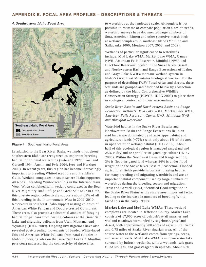
6.54 Intermountain West Joint Venture | C o n s e r v i n g H a b i t a t T h ro u g h P a r t n e r s h i p s | www.iwjv.orgIntermountain West Joint Venture | C o n s e r v i n g H a b i t a t T h ro u g h P a r t n e r s h i p s | www.iwjv.org
APPENDIX E. FOCAL AREA PROFILES – DESCRIPTIONS & THREATS
4. Southeastern Idaho Focal Area
Figure 4 Southeast Idaho Focal Area
In addition to the Bear River Basin, wetlands throughout southeastern Idaho are recognized as important breeding habitat for colonial waterbirds (Peterson 1977; Trost and Gerstell 1994; Austin and Pyle 2004, Ivey and Herziger 2006). In recent years, this region has become increasingly important to breeding White-faced Ibis and Franklin’s Gulls. Wetland complexes in southeastern Idaho supported 40% of all breeding White-faced Ibis in the Intermountain West. When combined with wetland complexes at the Bear River Migratory Bird Refuge and Great Salt Lake in Utah, this bi-state region collectively supports about 65% of all ibis breeding in the Intermountain West in 2009–2010. Reservoirs in southeast Idaho support nesting colonies of American White Pelican and Double-crested Cormorant. These areas also provide a substantial amount of foraging habitat for pelicans from nesting colonies at the Great Salt Lake and migrating pelicans from Utah, Montana, and Wyoming (IDFG 2009). Ongoing investigations have also revealed post-breeding movements of banded White-faced Ibis and American White Pelicans from natal colonies in Idaho to foraging sites on the Great Salt Lake (C. Moulton pers com) underscoring the connectivity of these sites
to waterbirds at the landscape scale. Although it is not possible to estimate or compare population sizes or trends, waterbird surveys have documented large numbers of Sora, American Bittern and other secretive marsh birds at wetland complexes in southeast Idaho (Moulton and Sallabanks 2006; Moulton 2007, 2008, and 2009).
Wetlands of particular significance to waterbirds include: Mud Lake WMA, Market Lake WMA, Camas NWR, American Falls Reservoir, Minidoka NWR and Blackfoot Reservoir located in the Snake River Basalt and Northwestern Basin and Range Ecosections of Idaho; and Grays Lake NWR a montane wetland system in Idaho’s Overthrust Mountains Ecological Section. For the purpose of describing IWJV Focal Areas and threats, these wetlands are grouped and described below by ecosection as defined by the Idaho Comprehensive Wildlife Conservation Strategy (ICWCS; IDFG 2005) to place them in ecological context with their surroundings.
Snake River Basalts and Northwestern Basin and Range Ecosection Wetlands: Mud Lake WMA, Market Lake WMA, American Falls Reservoir, Camas NWR, Minidoka NWR and Blackfoot Reservoir
Waterbird habitat in the Snake River Basalts and Northwestern Basin and Range Ecosections lie in an arid landscape dominated by shrub-steppe habitat and agricultural lands (~77%) with only about 1% of the area in open water or wetland habitat (IDFG 2005). About half of this ecological region is managed rangeland and 25% is dryland or sprinkler-irrigated agriculture (IDFG 2005). Within the Northwest Basin and Range section, 3% is flood-irrigated land whereas 16% is under flood irrigation in the Snake River Basalts Ecosection. Flooded agricultural fields provide important foraging habitat for many breeding and migrating waterbirds and are an important habitat component used by large numbers of waterbirds during the breeding season and migration. Trost and Gerstell (1994) identified flood-irrigation in the Snake River Plains as the single most important factor leading to the increase in numbers of breeding White-faced Ibis in the early 1990’s.
Market Lake and Mud Lake WMAs: These wetland complexes are located in Jefferson County. Market Lake consists of 17,000 acres of bulrush/cattail marshes and wetland meadows surrounded by sagebrush/grassland desert, with approximately 200 acres of agricultural fields and 0.75 miles of Snake River riparian area. All of the source water to the wetlands comes from springs, seeps, and artesian wells. Mud Lake WMA is an open water lake surround by bulrush wetlands, willow wetlands, salt-grass filled sloughs, and grass/sagebrush uplands. About 60%
6.55 Intermountain West Joint Venture | C o n s e r v i n g H a b i t a t T h ro u g h P a r t n e r s h i p s | www.iwjv.orgIntermountain West Joint Venture | C o n s e r v i n g H a b i t a t T h ro u g h P a r t n e r s h i p s | www.iwjv.org
APPENDIX E. FOCAL AREA PROFILES – DESCRIPTIONS & THREATS
of the 8,850 acre area is open water, 15% is emergent wetlands, and the remainder is a mix of upland habitats. Mud Lake is used as a water storage reservoir for the local canal company, and has seasonally fluctuating water levels. However, water levels are always sufficient for supporting large numbers of waterbirds throughout the summer (NAS 2011).
Moulton (2009) documented 12,250 pairs of White-faced Ibis and 14,426 pairs of Franklin’s Gull nesting in mixed, scattered colonies throughout impoundment areas at Market Lake WMA. Mud Lake WMA also hosts mixed colonies of White-faced Ibis (4,016 pairs) and Franklin’s Gull (13,074 pairs;C. Moulton pers com). In the fall, the Market Lake is a staging area for approximately 50 American White Pelicans, and pelicans forage and rest at Mud Lake WMA spring through fall (NAS 2011). Other nesting waterbirds at these sites include Black-crowned Night-heron, Great Blue Heron, Snowy Egret and Cattle Egrets; Eared, Western, and Clark’s Grebes; Forester’s Tern and Ring-billed gull.
Threats: At Market Lake, the water output of springs is only 25% that of the output in the 1970’s (IDFG 2005). Idaho Department of Fish and Game is investigating the potential to purchase water in the reservoir system for use in the marshes. Noxious weed species (e.g. Canada thistle, Musk thistle, Russian knapweed, field bindweed, and white top) are present at both WMAs and abatement measures underway include biological, mechanical, and chemical methods (IDFG 2005). Increasing public use at Mud WMA and demands for additional and different recreational activities could increase disturbance to waterbirds in the future.
Between 2000–2010 the human population in Jefferson County, Idaho grew 36.5%. With population growth comes increasing demand for land and water resources for housing and other municipal, agricultural, and recreational uses. To what extent waterbirds use the surrounding agricultural lands is unknown, but many of the species found at these WMAs utilize agricultural croplands for feeding. Conversions of agricultural lands to housing and other uses could affect the sustainability of large colonies of ibis and gulls at these sites in the future. Further, continued conversion of flood-irrigated agricultural lands in the Henry’s Fork corridor to sprinkler irrigation could ultimately eliminate the foraging habitat that sustains white-faced ibis populations nesting on Market Lake WMA.
Camas NWR: About 50% of this Refuge consists of lakes, ponds, and marshlands; the remainder is grass, sagebrush uplands, meadows, and farm fields (USFWS 2011). Primary habitats are cattail and hardstem bulrush marsh, and sagebrush steppe and bunchgrass uplands (IDFG 2005). Dense willow and cottonwood stands line stream sides. An extensive system of canals, dikes, wells, ponds, and water control structures allows water manipulatation for the benefit of wildlife. Colonial breeders include Eared Grebe, Western and Clark’s Grebe, Great Blue Heron, Black-crowned Night Heron, Snowy Egret, Great Egret, Cattle Egret, and Franklin’s Gull. Solitary breeders on site include Pied-billed Grebe, Horned Grebe, American Bittern, and Sora. Sandhill Cranes use this area as a fall staging site (USFWS 2011, NAS 2011).
Threats: The water supply at Camas has decreased over the years due to natural drought and agricultural development, which have lowered the water table. Camas Creek and Beaver Creek do not flow long enough to provide as much water as they once did and cannot sustain the refuge’s wetlands at certain times of the year, through wells and ditches have been constructed to provide additional water. Russian knapweed (Acroptilon repens) is present. Upstream channelization has increased sediment flow onto the refuge; increased groundwater pumping in agricultural lands upslope from the refuge have lowered the water table, drying up some of the marsh units. Further reductions of water supply will have significant consequences for waterbird habitat. (IDFG 2005; USFWS 2011).
Minidoka NWR: The Minidoka Dam and power plant on the Snake River was constructed in the early 1900s to provide water for irrigation and hydroelectric power. The refuge includes about 80 miles of shoreline around Lake Walcott, from Minidoka Dam upstream about 25 miles. Open water, marshes and mudflats provide habitat for an assortment of waterbirds. Large, shallow beds of submergent vegetation support warm water fish. These aquatic resources provide food for colonial nesting waterbirds including one of two American White Pelican colonies in Idaho, and colonies of Double-Crested Cormorant, Western and Clark’s Grebe, Great Blue Heron, Snowy Egret, and Black-crowned Night-heron. Following a period of absence (1950–1979) apparently due to disturbance from recreational boating, pelican numbers on the refuge increased from 1980–2010. IDFG (2009) reported pelicans numbered about 400 breeding birds in 2002 and increased to about 4,000 breeding birds in 2008. Moulton (pers comm) reported 700 breeding pairs of pelicans in 2010. Portions of the refuge are closed to
6.56 Intermountain West Joint Venture | C o n s e r v i n g H a b i t a t T h ro u g h P a r t n e r s h i p s | www.iwjv.orgIntermountain West Joint Venture | C o n s e r v i n g H a b i t a t T h ro u g h P a r t n e r s h i p s | www.iwjv.org
APPENDIX E. FOCAL AREA PROFILES – DESCRIPTIONS & THREATS
public access during the nesting season to protect the colonies from disturbance.
Threats: Lake Walcott is currently zoned to prevent boating disturbance to waterbird colony areas. There is a potential for disturbance to nesting and molting birds if the boating area is expanded. The population in surrounding Minidoka County has remained relatively unchanged 2000–2010 (U.S. Census 2011) thus threats associated with increasing demands on lands and water resources do not appear to be of concern at this time.
Blackfoot Reservoir: This open water reservoir includes several islands vegetated with sagebrush, willow riparian habitat, and surrounding sagebrush uplands. Gull Island (6 acres) supports the largest nesting colony of American White Pelicans in Idaho (1,400 nests in 2005) and large nesting colonies of Double-crested Cormorant (~300 pairs) and California Gull (~6,000 pairs;NAS 2011). Other waterbirds present include nesting colonies Great Blue Heron, Black-crowned Night-heron, and Snowy Egret. Fish species present include stocked rainbow trout and native Yellowstone cutthroat trout (YCT; Oncorhynchus clarkii bouvieri).
Threats: Reservoir levels can be drastically lowered for irrigation needs which exposes waterbirds to predation and increased disturbance, conditions that are exacerbated during drought or low water years. Fisheries managers are concerned about pelican and cormorant impacts on stocked rainbow trout, and on the native YCT, a species of special concern in the state. Pelican predation on YCT that migrate out of Blackfoot Reservoir into the Blackfoot River is a significant concern to IDFG and low flows in the Blackfoot River increases the loss of YCT to pelican predation (IDFG 2009). Fisheries managers have adjusted the timing of fish stocking and have implemented various methods of bird deterrence (hazing with zon guns, cracker shells, airboat, and flagged lines across the river) to exclude pelicans during the sensitive YCT migration period (IDFG 2009). Limited lethal take of pelicans (13 individuals in 2006 and 10 in 2008) was implemented in conjunction with non-lethal hazing program in an effort to increase the effectiveness of the hazing and to reduce impacts to the fishery.
IDFG has established a population five-year average population objective of 700 pelicans at Blackfoot Reservoir. Consultation with the USFWS to determine the feasibility, scope and duration of continued lethal control as one means to help minimize pelican predation on YCT is ongoing.
American Falls Reservoir: The reservoir is about 22 miles long, 6 miles wide at its widest point, and covers approximately 58,000 acres at full capacity. This is an irrigation reservoir with some associated wetland habitat. The surrounding area is predominantly sagebrush and agricultural lands. The reservoir provides shallow water feeding areas and mudflats for foraging shorebirds and waterbirds. Taylor et al. (1989) described thousands of post-breeding ibis feeding on chironomid fly larvae and a small oligochaete in the Springfield Bottoms, an extensive mudflat where the Snake River enters the reservoir. This shoreline constantly changed as water levels in the reservoir dropped during the summer and fall, offering a continual supply of soft substrate for feeding waterbirds.
Gull Island on American Falls Reservoir is the breeding site of the largest California and Ring-billed Gull colony in the state (NAS 2011). There were 7,455 California Gull nests in 2005 and 8,361 in 2006 and almost 800 pairs of Double-crested Cormorants (Moulton and Sallabanks 2006, Moulton 2007). Other breeding waterbirds found here include: Eared Grebe, Western and Clark’s Grebe, Great Blue Heron, Black-crowned Night Heron, Snowy Egret, Great Egret, Cattle Egret, Forster’s Tern, and Black Tern.
Threats: Pesticide and nutrient runoff from surrounding agricultural lands is of concern. Additionally, populations in the surrounding counties increased 2000-2010 with Bannock and Bingham County populations growing nearly 10% (U.S Census Bureau 2011). Increasing recreational use may result in increased disturbance to waterbirds.
Overthrust Mountains Ecological Section Wetland: Grays Lake NWR
Mountain ranges and valleys with scattered lakes and montane wet meadows characterize this region. Timber harvest, livestock grazing, and recreation are the primary land uses. The majority of precipitation falls as snow in the winter.
Grays Lake NWR: At 22,000 acres, Grays Lake is one of the largest hardstem bulrush marshes in North America. It is located in the Caribou Range of the Rocky Mountains on the western edge of the Greater Yellowstone Ecosystem. The high elevation marshland (6,400 ft) is surrounded by wet meadows and grasslands. Water sources are from snowmelt and numerous springs. Grays Lake NWR encompasses most of this habitat (19,500 acres) but water levels cannot be manipulated due to water rights and agreements with the Fort Hall Irrigation District and local landowners (USFWS 2011). Water discharge has been controlled by the Bureau of Indian Affairs for use in
6.57 Intermountain West Joint Venture | C o n s e r v i n g H a b i t a t T h ro u g h P a r t n e r s h i p s | www.iwjv.orgIntermountain West Joint Venture | C o n s e r v i n g H a b i t a t T h ro u g h P a r t n e r s h i p s | www.iwjv.org
APPENDIX E. FOCAL AREA PROFILES – DESCRIPTIONS & THREATS
Fort Hall Irrigation Project since the early 1920s. Clark’s Cut, a man-made channel completed in 1924, drains into the Blackfoot Reservoir via Meadow Creek. The refuge is considered prime habitat for Sandhill Cranes. During fall staging and migration, Greater Sandhill Cranes congregate in numbers up to 1,200 individuals and this site supports one of the largest breeding populations of Greater Sandhill Cranes in the world (~250 pairs). Franklin’s gulls nest in large colonies in bulrush habitat, along with lesser numbers of White-faced Ibis and grebes, bitterns and rails. There were 6,037 pairs of breeding ibises in 2010, 16,000 pairs of Franklin’s gulls, and 5,775 pairs of Ring-billed gulls in 2009.
Threats: Drought conditions and climate change may pose threats to the water supply at this site since water sources are from snowmelt and springs and water security for wildlife purposes is lacking. The Fort Hall Irrigation District has priority for water use. The Shoshone-Bannock tribes receive the majority of the water controlled by the district followed by privately owned lands. The timing and amount of water drained from this site is determined by the District with irrigation use being the priority rather than water management for waterbirds or other wildlife. The population in Bonneville County, Idaho increased 26.3% from 2000 to 2010 (U.S. Census Bureau 2011) which may increase demands for surface and ground water resources to meet domestic and industrial uses.
5. Upper and Middle Rio Grande Valleys, Colorado and New Mexico
Figure 5 Upper (San Luis Valley) and Middle Rio Grande Corridor
Colorado.—The Upper Rio Grande Basin is located in south-central Colorado and encompasses about 7,700 mi2 (San Luis Valley Wetlands Focus Area Committee 2000). Headwaters of the Rio Grande, Colorado’s Closed Basin and the San Luis Valley comprise the Basin. The area is bounded on the north and west by the Continental Divide, on the east by the Sangre de Cristo range, and the south by the New Mexico state line. The San Luis Valley lies at the headwaters of the Rio Grande River in the Basin and Range Province. Although they are widely scattered in this dry area, wetlands support dense waterbird populations. Many of Colorado’s largest and richest ponds, lakes, and marshes lie in the San Luis Valley. This region has an economy based on irrigation agriculture, tourism, livestock production, and mining. Cropland comprises about 9% of the basin, while an additional 4.3% of the basin exists as irrigated hay meadow. The human
6.58 Intermountain West Joint Venture | C o n s e r v i n g H a b i t a t T h ro u g h P a r t n e r s h i p s | www.iwjv.orgIntermountain West Joint Venture | C o n s e r v i n g H a b i t a t T h ro u g h P a r t n e r s h i p s | www.iwjv.org
APPENDIX E. FOCAL AREA PROFILES – DESCRIPTIONS & THREATS
population reflects the general decline occurring in rural areas; declining from a high of 49,000 in l940 to 42,000 at the turn of the century (San Luis Valley Wetlands Focus Area Committee 2000).
Virtually the entire Rocky Mountain Population (RMP) of Greater Sandhill Cranes stage in the Valley in October and March each year. Numerous other nongame waterbirds occur in the Valley at various times of the year. These species will be managed by providing the specific wetland habitat types required. The four types of habitat are emergent marsh, wet meadow, playa (mud flat) and open water.
Alamosa NWR: This 11,200 acre refuge consists of nearly 8,000 acres of wetlands, including open water with extensive cattail stands and Baltic rush/wet meadow communities, river oxbows, and riparian corridors, primarily within the flood plain of the Rio Grande. The refuge lies at just over 7,500 ft elevation and is relatively flat. Habitat management practices include high intensity-short duration grazing, prescribed burning, moist-soil plant management, farming, and water management. Water from the Rio Grande is supplemented by artesian wells and pumped water from the Closed Basin Project. The refuge has supported substantial nesting colonies of White-faced Ibises, Black-Crowned Night Herons, and Snowy and Cattle Egrets (San Luis Valley Wetlands Focus Area Committee 2000).
Blanca Wetlands Area: This is a wetlands development and restoration area administered by BLM. Lying just above 7,500 ft in elevation, the area is relatively flat with no significant topographic features. Sparsely vegetated sand dunes with intermingled depressions and historical playa basins characterize the landscape. The site provides 207 wetland sites (2,500 acres) consisting of fresh water ponds, marshes, and meadows; alkali ponds, marshes, and meadows; and playa lakes. Portions of this area have inadequate water supplies to meet their potential. The primary objective of the area is to serve as a waterbird production site (San Luis Valley Wetlands Focus Area Committee 2000). See Chapter 5b of the 2013 IWJV Implementation Plan for a more detailed characterization of the Blanca Wetlands Area.
Monte Vista NWR: This 14,200 acre refuge consists primarily of flat terrain at an elevation above 7,500 ft. It contains nearly 3,240 acres of wetlands. Water is intensively managed using numerous dikes and other water control structures to create wetland habitats ranging from shallow wet meadows to open water. Approximately 26,500 acre feet of water is applied annually to these areas to manage for seasonal waterbird needs, such as spring
breeding pair habitat and summer brood habitat. Water is provided through numerous artesian wells and pumps, and canal water diverted from the Rio Grande River. Other habitat management practices include high intensity-short duration grazing, prescribed burning, farming, and moist-soil plant management. The refuge is a major stopover for migrating RMP Greater Sandhill Cranes moving between their wintering area around Bosque del Apache NWR in New Mexico and northern breedin grounds. Up to 20,000 cranes pass through in the spring and again in the fall. The refuge also supports colonies of White-faced Ibis, Snowy and Cattle Egrets, and Black-Crowned Night Herons (San Luis Valley Wetlands Focus Area Committee 2000).
Threats: Development of resources including water, real estate, and agriculture are the primary threats to fish and wildlife resources in the San Luis Valley. Lack of secure water supplies and diminishing ground-water resources are the major threat to region wetlands.
New Mexico.—The Middle Rio Grande Valley of central New Mexico spans both the Chihuahuan desert scrub and semidesert grassland biotic communities and is bounded by mountain ranges rising 6,560 ft to the west and 5,250 ft to the east. This region lies along the Rio Grande and spans between Cochiti Dam to Elephant Butte Reservoir. Valley floor elevations average 4,820 ft. Wetlands within this valley are critical for supporting migrating and wintering waterfowl, cranes, and a wide variety of other waterbirds. The valley hosts 5 federal and state wildlife refuges, which cooperatively provide habitat for these species (Taylor 1999). Limited wetland availability within this arid landscape requires intensive management programs focused on maximum food production to support high numbers of cranes and waterfowl.
This region is the principal winter range for RMP Greater Sandhill Cranes that utilize west-central New Mexico, mainly from the Albuquerque-Los Lunas region in Bernalillo and Valencia counties south to the Bosque del Apache NWR (Drewien and Bizeau 1974, Drewien et al. 2000), as well as a growing number of Mid-Continent Population Sandhill Cranes. Most greaters winter at or near the Bosque del Apache NWR or areas 40-mi north near Bernardo Waterfowl Managemant Area and La Joya Wildlife Area. Smaller groups are scattered throughout the valley north to Tome and Los Lunas areas in Valencia County (Drewien and Bizeau 1974). Flock counts and observations of marked cranes show that Bosque del Apache NWR is the RMP’s single most important wintering location with over 50% of the entire population wintering here (Drewien and Bizeau 1974).
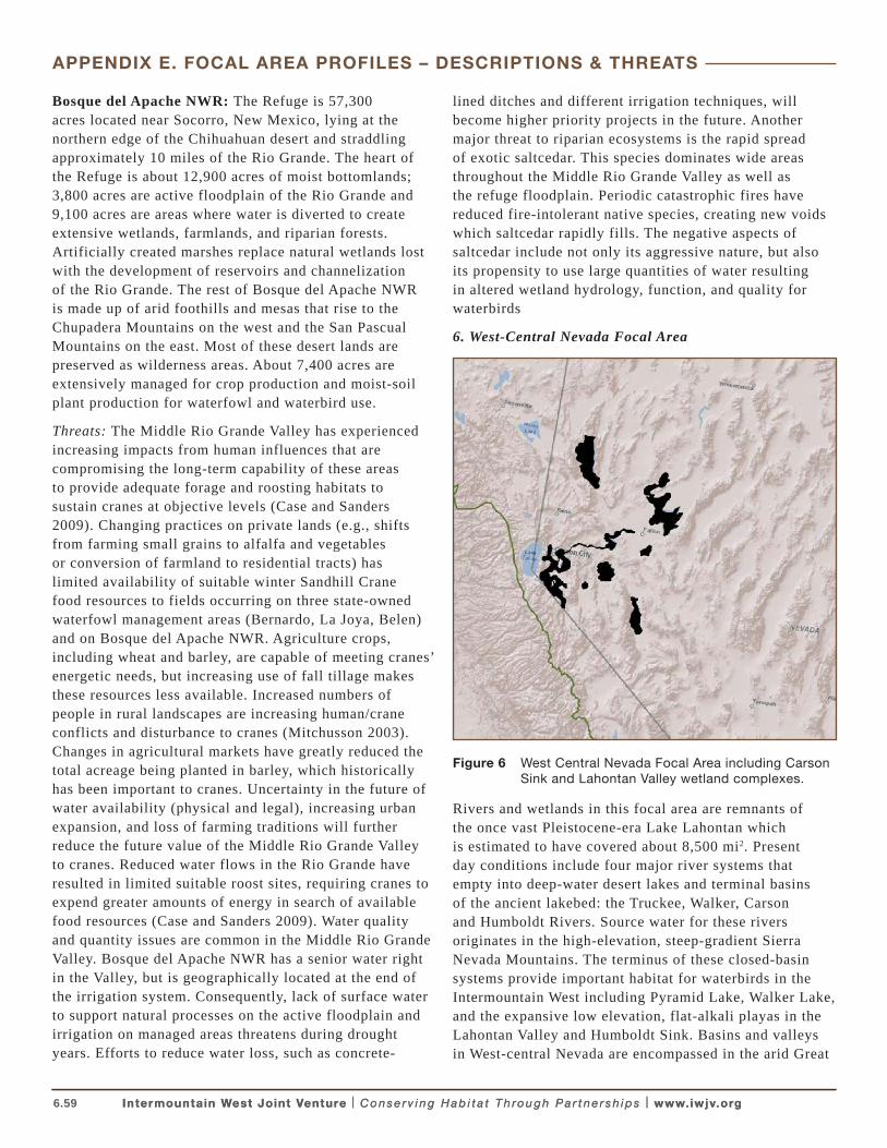
6.59 Intermountain West Joint Venture | C o n s e r v i n g H a b i t a t T h ro u g h P a r t n e r s h i p s | www.iwjv.orgIntermountain West Joint Venture | C o n s e r v i n g H a b i t a t T h ro u g h P a r t n e r s h i p s | www.iwjv.org
APPENDIX E. FOCAL AREA PROFILES – DESCRIPTIONS & THREATS
Bosque del Apache NWR: The Refuge is 57,300 acres located near Socorro, New Mexico, lying at the northern edge of the Chihuahuan desert and straddling approximately 10 miles of the Rio Grande. The heart of the Refuge is about 12,900 acres of moist bottomlands; 3,800 acres are active floodplain of the Rio Grande and 9,100 acres are areas where water is diverted to create extensive wetlands, farmlands, and riparian forests. Artificially created marshes replace natural wetlands lost with the development of reservoirs and channelization of the Rio Grande. The rest of Bosque del Apache NWR is made up of arid foothills and mesas that rise to the Chupadera Mountains on the west and the San Pascual Mountains on the east. Most of these desert lands are preserved as wilderness areas. About 7,400 acres are extensively managed for crop production and moist-soil plant production for waterfowl and waterbird use.
Threats: The Middle Rio Grande Valley has experienced increasing impacts from human influences that are compromising the long-term capability of these areas to provide adequate forage and roosting habitats to sustain cranes at objective levels (Case and Sanders 2009). Changing practices on private lands (e.g., shifts from farming small grains to alfalfa and vegetables or conversion of farmland to residential tracts) has limited availability of suitable winter Sandhill Crane food resources to fields occurring on three state-owned waterfowl management areas (Bernardo, La Joya, Belen) and on Bosque del Apache NWR. Agriculture crops, including wheat and barley, are capable of meeting cranes’ energetic needs, but increasing use of fall tillage makes these resources less available. Increased numbers of people in rural landscapes are increasing human/crane conflicts and disturbance to cranes (Mitchusson 2003). Changes in agricultural markets have greatly reduced the total acreage being planted in barley, which historically has been important to cranes. Uncertainty in the future of water availability (physical and legal), increasing urban expansion, and loss of farming traditions will further reduce the future value of the Middle Rio Grande Valley to cranes. Reduced water flows in the Rio Grande have resulted in limited suitable roost sites, requiring cranes to expend greater amounts of energy in search of available food resources (Case and Sanders 2009). Water quality and quantity issues are common in the Middle Rio Grande Valley. Bosque del Apache NWR has a senior water right in the Valley, but is geographically located at the end of the irrigation system. Consequently, lack of surface water to support natural processes on the active floodplain and irrigation on managed areas threatens during drought years. Efforts to reduce water loss, such as concrete-
lined ditches and different irrigation techniques, will become higher priority projects in the future. Another major threat to riparian ecosystems is the rapid spread of exotic saltcedar. This species dominates wide areas throughout the Middle Rio Grande Valley as well as the refuge floodplain. Periodic catastrophic fires have reduced fire-intolerant native species, creating new voids which saltcedar rapidly fills. The negative aspects of saltcedar include not only its aggressive nature, but also its propensity to use large quantities of water resulting in altered wetland hydrology, function, and quality for waterbirds
6. West-Central Nevada Focal Area
Figure 6 West Central Nevada Focal Area including Carson Sink and Lahontan Valley wetland complexes.
Rivers and wetlands in this focal area are remnants of the once vast Pleistocene-era Lake Lahontan which is estimated to have covered about 8,500 mi2. Present day conditions include four major river systems that empty into deep-water desert lakes and terminal basins of the ancient lakebed: the Truckee, Walker, Carson and Humboldt Rivers. Source water for these rivers originates in the high-elevation, steep-gradient Sierra Nevada Mountains. The terminus of these closed-basin systems provide important habitat for waterbirds in the Intermountain West including Pyramid Lake, Walker Lake, and the expansive low elevation, flat-alkali playas in the Lahontan Valley and Humboldt Sink. Basins and valleys in West-central Nevada are encompassed in the arid Great
6.60 Intermountain West Joint Venture | C o n s e r v i n g H a b i t a t T h ro u g h P a r t n e r s h i p s | www.iwjv.orgIntermountain West Joint Venture | C o n s e r v i n g H a b i t a t T h ro u g h P a r t n e r s h i p s | www.iwjv.org
APPENDIX E. FOCAL AREA PROFILES – DESCRIPTIONS & THREATS
Basin Region with precipitation in ranging from about 5–8 in/year (Maurer et. al., 2009; USFWS 2002) and annual evaporation that can exceed 60 in/year. (USFWS 2002). Uplands in the region are dry, desert shrublands and land use is predominantly agriculture, grazing and ranching.
About 82% of wetland acreage in the terminal valleys of the Truckee, Carson, and Humboldt River basins were lost through conversion or development since the 1850’s (Thompson and Merritt 1988). These rivers, and the Walker River, have been highly modified by complex networks of dams, reservoirs, ditches and canals that serve to store, divert, transport and withdraw water to support extensive agricultural and ranching practices in surrounding valleys, especially in Douglas, Lyon, Mineral, and Churchill Counties, Nevada. Despite the severe alterations to the natural hydrologic conditions in these basins, they continue to support regionally and nationally significant populations of waterbirds, shorebirds and waterfowl. From the mid-1980s through the late 1990s, a significant proportion of White-faced Ibises in the Intermountain West were located in colonies in the Lahontan Valley/Humboldt Sink wetlands (Neel 1997, Earnst et al 1998). The area also serves as an important foraging area for American White Pelicans from breeding colonies Anaho Island NWR, and as breeding and foraging habitat for hundreds of Snowy Egrets, Great Egrets, Black-crowned Night-Herons and Double-Crested Cormorants (Neel 1997, GBBO 2010). Pyramid and Walker Lakes support waterbirds able to exploit resources found in deep saline waters and surrounding alkali and fresh-water wetlands including American White Pelicans, California Gulls, Double-crested Cormorants, Common Loons, and Clark’s and Western Grebes.
In 1990, Congress passed The Truckee-Carson-Pyramid Lake Water Rights Settlement Act, Public Law 101-618 (PL101-118) which authorizes the transfer of the 22,700 acre Carson Lake and Pasture area to the State of Nevada to be managed by NDOW as a WMA. Additionally, PL 101-618 mandates the Department of the Interior to acquire, in conjunction with the State of Nevada, enough water to sustain a long-term average of 24,700 acres of primary wetland habitat in four designated areas in the Lahontan Valley: Stillwater NWR, Stillwater WMA, Carson Lake WMA and the Fallon Paiute-Shoshone Reservation.
Lahontan Valley/Humboldt Sink Wetlands: The Lahontan Valley/Humboldt Sink wetlands are low elevation terminal basins characterized by desert shrublands and vast, flat- alkali playas and mudflats. The Carson River Basin includes an estimated 12,600
acres of open water, 91,000 acres of vegetated wetlands and 155,000 acres of alkali playa (Nevada Natural Heritage Program [NNHP] 2006). Desert shrublands and playas characterize the lower basins whereas wetlands, farmlands, the City of Fallon and associated suburbs comprise a small component (7%) of the Lahontan Valley (USFWS 2002). In 2005 there were about 39,000 acres of irrigated native pasture and alfalfa in the Carson Valley below Lahontan Reservoir, and an additional 3,100 acres and 1,200 acres were flood irrigated in the Dayton and Churchill Valleys above the reservoir. In recent years, the Carson River basin has experienced increases in residential, commercial and municipal growth (Maurer et al 2009). Grazing, rangelands, and agriculture represent the predominant land use (USFWS 2002).
North of the Carson River system, the Humboldt River terminates in the Humboldt Sink an expansive alkali pan wetland complex with water ranging from centimeters to 13 feet deep depending upon annual flow levels (Nevada Partners in Flight [NPIF] 1999). The Humboldt River and its tributaries drain a 17,200 mi2 basin which includes nearly 12,100 acres of playa, 510 mi2 of vegetated wetland habitat, and 16,100 acres of open water (NNHP 2006). The Carson Sink is hydrologically connected to the Humboldt River Basin via the Humboldt River and the Humboldt Slough. However, water entering the Carson Sink from the Humboldt River Basin via this connection occurs only during extremely wet years.
In 1915 the Newlands Irrigation Project was completed to provide irrigation water for agriculture in the lower Carson River Basin. This included construction the Lahontan Dam and Reservoir on the Carson River and the Truckee Canal which diverts Truckee River flows into the Lahontan Reservoir. Water from the Lahontan Reservoir irrigates about 56,000 acres in the Lahontan Valley (Maurer et. al., 2009). Flows not used for irrigation provide water for Lahontan Valley wetlands, including the Carson Sink at the basins terminus. The Humboldt River is similarly altered with four reservoirs including Rye Patch. Constructed in 1935, the Rye Patch Reservoir effectively cut-off the wetlands of the Humboldt Sink from Humboldt River source water (NPIV 1999). Humboldt Sink wetlands are now supplied with agricultural return flows when they are available
The Stillwater NWR Complex and Carson Lake WMA (AKA Carson Lake and Pasture) comprise the majority of the Lahontan Valley wetland complex. The Stillwater NWR Complex includes the Stillwater NWR, the adjacent Stillwater WMA, and Fallon NWR for a combined total of 163,000 acres of land managed by the USFWS. The
6.61 Intermountain West Joint Venture | C o n s e r v i n g H a b i t a t T h ro u g h P a r t n e r s h i p s | www.iwjv.orgIntermountain West Joint Venture | C o n s e r v i n g H a b i t a t T h ro u g h P a r t n e r s h i p s | www.iwjv.org
APPENDIX E. FOCAL AREA PROFILES – DESCRIPTIONS & THREATS
Carson Lake WMA (22,000 acres) is federally owned land managed by the NDOW pending transfer to the state per PL 101-618. Additional wetlands are located on the Fallon Paiute-Shoshone Reservation, and along the Carson River and the Carson Sink terminus. NDOW manages the 27,900 acre Humboldt Sink WMA. Habitats for waterbirds on these lands include freshwater and brackish marshes, shallow flooded alkali playas and associated mudflats, and cottonwood and willow riparian areas. Surrounding uplands are salt desert shrub lands, sand dunes, and extensive irrigated crop and pasturelands.
The extent and quality of wetland habitats in the Lahontan Valley/Humboldt Sink vary tremendously both seasonally and annually, depending on snowpack levels in the Sierra Nevada and on withdrawals for irrigation, municipal, and residential uses. Within the span of one season, these wetlands can transform from shallow lakes with clear, fresh water, to shallow, brackish marshes with high salt concentrations (USFWS 2002). Numbers of waterbirds recorded at these sites fluctuate in accord with water levels and widely ranging salinity levels. However, the region is renowned for supporting thousands of waterbirds and high concentrations of shorebirds and waterfowl.
Between 1992–1997, Neel (1997) estimated about 4,083 breeding pairs of White-faced Ibis annually inhabiting wetlands in northwestern Nevada. Carson Lake WMA traditionally hosted the largest ibis colonies among the Lahontan Valley/Humboldt Sink wetland sites. During this same 5-year period, about 300 nesting pairs of Snowy Egrets, and 160 pairs of Great Egrets, 180 Black-crowned Night Herons and lesser number of Cattle Egret and Double-crested Cormorants were documented nesting in these wetlands. Numbers of nesting ibises declined dramatically 2000–2004 corresponding with severe drought conditions. Although water conditions at wetlands improved in 2005–2006 and in some later years, ibises have yet to rebound to the high counts of the late 1990s. However, these wetlands continue to serve as part of the network of sites necessary to support Intermountain West waterbird populations over the long term. The Lahontan Valley wetlands also serve a vital function as shallow-water feeding areas for American White Pelicans from the breeding colony on Anaho Island in Pyramid Lake (up to 13,000 birds). Pelicans from Anaho Island frequently travel about 70 miles one-way to feed in shallow water bodies in the Lahontan Valley. Common Loons and Sandhill Cranes were also once common to these wetlands but loss of deep water and wet meadow habitat has greatly reduced the number of these waterbirds from historic times (USFWS 2002)
Threats: Water supply, security, and quality are significant threats to waterbird habitat in the Lahontan Valley wetlands. Flows from the Carson and Truckee Rivers are fully allocated, almost entirely to off-stream uses including agriculture, urban, and industrial use. Water that ultimately flows into the terminal lakes and sinks is a mixture of re-used surface and groundwater (NNHP 2006). In addition to historic loss of wetland acreage, recent suburban and municipal growth is permanently converting habitat in these basins. From 1970 to 2005, about 2,200 acres of land below Lahontan Reservoir were converted from irrigated agricultural land to residential and commercial use (Maurer et. al., 2009). In the past decade (2000–2010) counties in west-central Nevada experienced relatively high rates of population growth with increases of 51% in Lyon County, 14% in Douglas County, 29% in Washoe County and nearly 4% in Churchill County (U.S Census Bureau 2011). Municipal, commercial, and subdivision developments have further impacted water and wetland resources. From the late 1980s to 2005, about 6,300 acres of land have been converted from flood irrigation to sprinkler systems (Maurer 2009), thereby degrading their value to foraging waterbirds. Ongoing and predicted increases in temperature associated with climate change could potentially increase already severe evaporation rates in the Lahontan Valley/Humboldt Sink. Predicted declines in Sierra Nevada snowpack and earlier spring snowmelt dates could drastically modify water regimes in the mid- to late-summer seasons when waterbirds are nesting and fledging young. The effects of climate change will exacerbate water shortages and poor water quality in these drainages that are already stressed by limited water and contaminants.
Contaminant concerns in the Lower Lahontan and Humboldt River Basins result primarily from hydrologic modifications, discharge of agricultural drainage to wetlands, and the historic release of mercury into the Carson River (Henny et al. 1985, Henny and Herron 1989, Henny et al 2002, Oring et al 2000). During the mid to late 1800s, mining activities for precious metals resulted in the release of liquid mercury into the Carson River. Mercury concentrations in the floodplain of the Lower Carson River Basin are some of the highest ever reported, and Lahontan Reservoir has served as a sink for most of the sediment-bound mercury washed downstream (Hill et. al., 2008). The Lower Carson River Basin, including Lahontan Reservoir is now on the U.S. Environmental Protection Agency’s National Priorities List (Superfund) for research and cleanup. Mercury contamination has resulted in cellular damage in the nervous, immune, hepatic, and renal systems of young Snowy Egrets, Black-crowned
6.62 Intermountain West Joint Venture | C o n s e r v i n g H a b i t a t T h ro u g h P a r t n e r s h i p s | www.iwjv.orgIntermountain West Joint Venture | C o n s e r v i n g H a b i t a t T h ro u g h P a r t n e r s h i p s | www.iwjv.org
APPENDIX E. FOCAL AREA PROFILES – DESCRIPTIONS & THREATS
Night Herons, and Double-crested Cormorant fledgling from colonies in the Lahontan Reservoir (Henny et al 2002). During the drought years of 2000–2004, Hill et al. (2008) found snowy egret eggs with high concentrations of total mercury and methylmercury (> .80ug TH) all failed to hatch. Yet during wet years, substantial numbers of young were produced from nests with eggs thus exceeding these thresholds. Drought conditions exacerbate the negative physiological reproductive effects of mercury contamination in snowy egret nestlings (Hoffman et. al., 2009). These studies revealed complex associations among contaminant levels and drought/flood conditions in the Lahontan Valley that merit further research and emphasize the critical need to improve water supply and quality to wetlands in the Lahontan Valley and Humboldt Sink.
Pyramid Lake /Anaho Island NWR: Pyramid Lake is a 125,000 acre natural saline lake and is one of the largest and deepest (338 ft) remnants of ancient Lake Lahontan. The lake supports amphipods, fish including the endangered Cui-ui, and other aquatic species that provide a forage base for waterbirds. The island constitutes the entire extent of the Anaho Island NWR, which is managed by the USFWS under an agreement with the Pyramid Lake Paiute Tribe. Derby Dam and Truckee Canal were constructed in 1913 to divert Truckee River water to the Lower Carson River Basin for irrigation. This reduced the flow of water into Pyramid Lake and consequently, the island fluctuates in size from 220 to 740 acres depending on water supply. Anaho Island is characterized by gentle slopes near the shoreline and steep, rocky topography toward its peak. Island habitat includes desert shrub communities, nonnative annual grasses, native bunchgrasses and forbs, and open areas with scant vegetation near the shorelines.
Anaho Island supports some of the largest concentrations of colonial waterbirds in Nevada, including a long-persistent breeding colony of American White Pelicans. The number of American White Pelicans at Anaho Island over the past 50 years has varied from 2,670 to 21,500 birds, with an annual average of 8,600 and a typical ten-year peak of 13,500 birds (Stillwater NWR Complex data). In 2009 and 2010, refuge waterbird surveys documented an average of 3,760 breeding pairs of pelicans, 3,565 pairs of California Gulls, and about 400 pairs of Double-crested Cormorants breeding on the island within 18 subcolonies (GBBO 2010). In 2011, about 4,000 pairs of pelicans produced roughly 2,000 young (Stillwater NWR Complex data). This relatively high reproductive success was attributed to high water levels from reserve snowpack in the Sierra Nevada Range resulting in above average flows in the Truckee River, the main inflow to Pyramid
Lake. Great blue herons, Black-crowned night herons and occasionally Caspian Terns also nest on the island (USFWS 2002). Pyramid Lake provides migration stop-over opportunities for significant numbers of waterbirds. Large numbers of Clark’s and Western Grebes, Eared Grebes, and American White Pelicans pass through in migration (NAS 2011).
Threats: Pyramid Lake has experienced deficit inflows from the Truckee River since the early 1900s when diversions began from the lower Truckee River at Derby Dam. Although legislative action has somewhat stabilized Truckee River water allocations, continued withdrawals and drought cycles represent the primary threats to the quantity and quality of water in Pyramid Lake. In turn, these factors threaten the sustainability of Cui-ui and Lahontan Cutthroat Trout populations, the primary food source for pelicans and other waterbirds that congregate to nest on Anaho Island. Declining snow pack and earlier snowmelt dates predicted in various climate change models would reduce magnitude and duration of snow-melt dependent flows in the Truckee and Carson Rivers. In turn, this could potentially result in increased salinity at Pyramid Lake and insufficient water to wetlands in the Lahontan Valley.
Walker Lake: The Walker River drains the 4050 mi2 Walker River Basin and empties into Walker Lake, located about 160 miles from the rivers headwaters in the Sierra Nevada Mountains. This 12 mile long, 5 mile wide desert-terminal lake covers about 25,900 acres. The shoreline is predominantly barren with some scattered low-desert shrub vegetation, with the exception of the river delta area where limited riparian/wetland community types occur. Over the past 100 years, the lake has decreased from about 10 million to less than 2 million acre feet (Horton 1996). Virtually all surface water flows within the Walker River Basin are appropriated for agricultural use (Horton 1996), and are diverted onto tens of thousands of acres of alfalfa, onion, and garlic fields and to support cattle grazing. Extensive ground water pumping also occurs to meet the water needs of the surrounding agricultural communities in Douglas, Mineral, and particularly Lyon counties, Nevada (Horton 1996, Sharpe et al 2007). As a result of surface and groundwater withdrawals, water supply to the lake has declined significantly and, consequently, concentration of salt and total dissolved solids has dramatically increased. Lake water is of relatively poor quality, with high concentrations of total dissolved solids, (mostly salts), relatively high temperatures, low dissolved oxygen, and hydrogen sulfide (Horton 1996, Sharpe et al 2007).
6.63 Intermountain West Joint Venture | C o n s e r v i n g H a b i t a t T h ro u g h P a r t n e r s h i p s | www.iwjv.orgIntermountain West Joint Venture | C o n s e r v i n g H a b i t a t T h ro u g h P a r t n e r s h i p s | www.iwjv.org
APPENDIX E. FOCAL AREA PROFILES – DESCRIPTIONS & THREATS
Despite these Walker Lake is one of only three desert terminus lakes in the U.S. that support a fishery. A population of the native Lahontan tui chub (Gila bicolor) and a stocked strain of the threatened Lahontan Cutthroat Trout (Oncorhynchus clarkii henshawi) inhabit the headwaters of the Walker River and Walker Lake. Common loons stage at Walker Lake for about 30 days during southward fall migration and during the spring migration as they head north to breeding grounds in Saskatchewan, Canada. NDOW bi-annual surveys at Walker Lake have documented a high count of 1,433 loons during the spring of 1997 to a low of 150 during the spring of 2009. The lake also hosts between 2,000 and 9,000 migrating Clark’s Grebes each fall, as well as Eared Grebes, Double-Crested Cormorants, White-faced Ibises, and American White Pelicans.
Threats: Surface water withdrawals for agricultural and ranching purposes, the increasing frequency and duration of drought cycles, and reduced snowpack in the Sierra Nevada Mountains resulting from climate change are significant threats to waterbirds and waterbird habitat at Walker Lake. These ongoing water shortages and droughts have necessitated increasing ground water withdrawals from the Walker River Basin to support agriculture in the surrounding landscape, further stressing hydrologic conditions in the lake. Due to surface and ground water diversions and withdrawals over the past century, the lake’s level has declined by 47 m and its volume has shrunk by more than 80% (Bureau of Reclamation 2010). During the ten-year period of 1987–1996, an eight-year drought period, Walker Lake received inflows from the
Walker River in essentially only three years: 1987, 1995, and 1996 (Horton 1996, Bureau of Reclamation 2010). Walker Lake’s TDS concentrations are well above levels existing in Pyramid Lake and are approaching levels that exceed conditions where fish can reproduce (Horton 1996, Sharpe et. al., 2007). The lake also experiences large blooms of blue-green algae, which, when combined with high TDS concentrations and low dissolved oxygen, creates a relatively inhospitable environment to fish species. Collapse of the fisheries would result in the complete loss of this site as an important waterbird migration and staging area. Additionally, mercury contamination from historical upstream mining has also occurred and looms at Walker Lake are heavily contaminated with mercury (NAS 2011). All of these conditions result in significant threats to waterbirds at the local and regional scale.
Since 2002, Congress has passed eight pieces of Desert Terminal Lakes Legislation related to the Walker River Basin. The overall direction and goal of programs stemming from these laws is to increase the long-term average annual inflow to Walker Lake by up to 50,000 acre feet per annually through purchases of water from willing sellers in Nevada. As directed by legislation and subsequent agreements among responsible and participating parties, the National Fish and Wildlife Foundation will determine how the Acquisition Program is to be developed and implemented (see Revised DEIS for the Walker River Basin Acquisition Program, Department, Bureau of Reclamation, 2010)
6.64 Intermountain West Joint Venture | C o n s e r v i n g H a b i t a t T h ro u g h P a r t n e r s h i p s | www.iwjv.org
Akins, G. J. 1970. The effects of land use and land management on the wetlands of the Upper Klamath Basin. M.S. Thesis. Western Washington College, Bellingham, Washington.
Aldrich, T. W., and D. S. Paul. 2002. Avian ecology of Great Salt Lake. Pages 343–374 in J. W. Gwynn, editor. Great Salt Lake: an overview of change. Utah Department of Natural Resources and Utah Geological Survey Special Publication, Salt Lake City, Utah, USA.
Austin, J. E. and W. H. Pyle. 2004. Nesting Ecology of Waterbirds at Grays Lake, Idaho. Western North American Naturalist 64: 277–292.
Bedford, D., and A. Douglass. 2008. Changing properties of snowpack in the Great Salt Lake Basin, Western United States, from a 26-year SNOTEL record. Professional Geographer 60:374–386.
Belovsky, G. E., D. Stephens, C. Perschon, P. Birdsey, D. Paul, D. Naftz, R. Gaskin, C. Larson, C. Mellison, J. Luft, R. Mosley, H. Mahon, J. V. Leeuwn, and D. V. Allen. 2011. The Great Salt Lake ecosystem (Utah, USA): long term data and a structural equation approach. Ecosphere 2:1–40.
Bray, M.P. and D. A. Klebenow, 1988. Feeding ecology of White-faced Ibis in a Great Basin Valley, USA. Colonial Waterbirds 11:24-31.
Bureau of Reclamation [BOR]. 2010. Revised Draft Environmental Impact Statement for the Walker River Basin Acquisition Program. Online: http://www.usbr.gov/mp/nepa/nepa_projdetails.cfm?Project_ID=2810
Case, D. J. and S. J. Sanders. 2009. Priority Information needs for Sandhill Cranes: A funding strategy. Developed by the Association of Fish and Wildlife Agencies’ Migratory Shore and Upland Game Bird Support Task Force. Online: http://www.fws.gov/migratorybirds/NewReportsPublications/Research/WMGBMR/Priority_Information_Needs_for_Sandhill_Cranes_10-09-09_FINAL.pdf
Conover, M. R. and J. L. Vest. 2009a. Selenium and mercury concentrations in California Gulls breeding on the Great Salt Lake, Utah, USA. Environmental Toxicology and Chemistry. 28:324–329.
Conover, M. R. and J. L. Vest. 2009b. Concentrations of selenium and mercury in Eared Grebes from Utah’s Great Salt Lake, USA. Environmental Toxicology and Chemistry 28:1319–1323.
Copeland, H., S. Tessmann, M. Hogan, S. Jester, A. Orabona, S. Patla, K. Sambor, and J. Kiesecker. 2010. Wyoming Wetlands: Conservation Priorities and Strategies. Lander, Wyoming: The Nature Conservancy. 9pp.
Downard, R. 2010. Keeping wetlands wet: The hydrology of wetlands in the Bear River Basin. 2010. All Graduate Theses and Dissertations. Paper 829. Utah State University. Graduate Studies, School of DigitalCommons@USU. Online: http://digitalcommons.usu.etd/829
Drewien, R. C., and E. G. Bizeau. 1974. Status and distribution of greater sandhill cranes in the Rocky Mountains. Journal of Wildlife Management 38:720-742.
Drewien, R. C., W. M. Brown, D. C. Lockman, W. L. Kendall, K. R. Clegg, V. K. Graham, S. S. Manes. 2000. Band recoveries, mortality factors, and survival of Rocky Mountain greater sandhill cranes. Unpublished report, Hornocker Wildlife Institute, Bozeman, MT.
Earnst, S.L., L. Neel, G.L. Ivey, and T. Zimmerman. 1998. Status of the White-faced Ibis: Breeding Colony Dynamics of the Great Basin Population, 1985 – 1997. Colonial Waterbirds: 20: 301-476.
Fleskes, J. P., and C. J. Gregory. 2010. Distribution and dynamics of waterbird habitat during spring in southern Oregon–Northeastern California. Western North American Naturalist 70:26–38.
Frey, S. N., and M. R. Conover. 2006. Habitat use by meso-predators in a corridor environment. Journal of Wildlife Management 70:1111-1118.
Gannett, M.W., K. E. Lite, Jr., J.L. La Marche, B.J. Fisher, and D.J. Polette, 2007. Ground-water hydrology of the upper Klamath Basin, Oregon and California. U.S. Geological Survey Scientific Investigations Report 2007-5050. 84 pp.
Great Basin Bird Observatory. 2010. Surveys of Colonial Waterbirds within Nevada, 2010. Final Annual Report. Unpublished Report to American Bird Conservancy and U.S. Fish and Wildlife Service, Reno Nevada. 19 pp.
Henny, C.J., L.J. Blus, and C.S. Hulse. 1985. Trends and effects of organochlorine residues on Oregon and Nevada wading birds. Colonial Waterbirds 8:117-128
Henny, C.J. and G.B. Herron. 1989. DDE, selenium, mercury and White-faced Ibis reproduction at Carson Lake, Nevada. Journal of Wildlife Management. 53:1032-1045.
APPENDIX F. LITERATURE CITED IN APPENDICES
6.65 Intermountain West Joint Venture | C o n s e r v i n g H a b i t a t T h ro u g h P a r t n e r s h i p s | www.iwjv.org
Henny, C.J., E.F. Hill, D.J. Hoffman, M. G. Spalding, and R.A. Brove. 2002. Nineteenth century mercury: Hazard to wading birds and cormorants of the Carson River, Nevada. Ecotoxicology 11:213-231.
Hill, E.F., C. J. Henny, and R.A. Grove. 2008. Mercury and drought along the Lower Carson River, Nevada: II. Snowy Egret and Black-crowned Night-heron reproduction on Lahontan Reservoir, 1997-2006. Ecotoxicology 17:117-131.
Hoffman, D. J., C.J. Henny, E.F Hill, R.A. Grove, J.L. Kaiser, and K.R. Stebbins, 2009. Mercury and drought along the Lower Carson River, Nevada: III. Effects on blood and organ biochemistry and histopathology of Snowy Egrets and Black-crowned Night-Herons on Lahontan Reservoir, 2002–2006. Journal of Toxicology and Environmental Health, Part A, 72: 1223–1241.
Horton, G. 1996. Walker River Chronology: A chronological history of the Walker River and related water issues. Nevada Division of Water Planning, Carson City, NV. 80pp. Online: http://water.nv.gov/mapping/chronologies/walker/part1.cfm
Idaho Department of Fish and Game [IDFG], 2005. Idaho Comprehensive Wildlife Conservation Strategy (ICWCS). Idaho Conservation Data Center, Idaho Department of Fish and Game, Boise, Idaho. Online: http://fishandgame.idaho.gov/cms/tech/CDC/cwcs.cfm
Idaho Department of Fish and Game [IDFG], 2009. Management of American White Pelicans In Idaho: A five-year plan (2009–2013) to balance American white pelican and native cutthroat trout conservation needs and manage impacts to recreational fisheries in southeast Idaho. 72pp.
Ivey, G. L. 2000. Joint Venture Implementation Plans for Habitat Conservation Areas in Eastern Oregon: Oregon Closed Basin. Oregon Wetlands Joint Venture, Portland, Oregon. Online: www.ohjv.org/pdfs/closed_basin_plan.pdf.
Ivey, G. L. 2001. Joint Venture Implementation Plans for Habitat Conservation Areas in Eastern Oregon: Klamath Basin. Oregon Wetlands Joint Venture, Portland, Oregon. Online: www.ohjv.org/pdfs/klamath_basin %20.pdf.
Ivey, G. L., J. E. Cornely, and B. D. Ehlers. 1998. Carp impacts on waterfowl at Malheur National Wildlife Refuge, Oregon. Transactions North American Wildlife and Natural Resource Conference 63:66 74.
Ivey, G. L., and C. P. Herziger. 2000. Distribution of greater sandhill crane pairs in Oregon, 1999/00. Oregon Department of Fish and Wildlife Nongame Technical Report #03-01-00. Salem, Oregon.
Ivey, G.L. and C.P. Herziger. 2006. Intermountain West Waterbird Conservation Plan, Version 1.2. A plan associated with the Waterbird Conservation for the Americas Initiative. Published by U.S. Fish and Wildlife Service, Pacific Region, Portland, Oregon.
Ivey, G. L., S. L. Earnst, E. P. Kelchlin, L. Neel, and D. S. Paul. 2004. White-faced Ibis staus update and guidelines: Great Basin Population. U.S. Fish and Wildlife Service, Portland, Oregon, USA.
Kenny, J.F., N.L. Barber, S.S. Hutson, K.S. Linsey, J.K. Lovelace, and M.A. Maupin. 2009. Estimated use of water in the United States in 2005: U.S. Geological Survey Circular 1344, 52 pp.
Maurer, D.K., A.P. Paul, D.L. Berger, and C.J. Mayers, 2009. Analysis of streamflow trends, ground-water and surface-water interactions, and water quality in the upper Carson River Basin, Nevada and California: U.S. Geological Survey Scientific Investigations Report 2008–5238, 192 pp.
Naftz, D., C. Angeroth, T. Kenney, B. Waddell, N. Darnell, S. Silva, C. Perschon, and J. Whitehead. 2008. Anthropogenic influences on the input and biogeochemical cycling of nutrients and mercury in Great Salt Lake, Utah, USA. Applied Geochemistry 23:1731–1734.
Neill, J., J. O. Hall, and J. Luft. 2009. 2009 American white pelican census, Gunnison Island, Utah. Great Salt Lake Ecosystem Program and Utah Division of Wildlife Resources unpublished report. Utah Division of Wildlife Resources, Salt Lake City, Utah, USA.
Olson, B. 2009. Annual habitat management plan: Bear River Migratory Bird Refuge. Bear River Migratory Bird Refuge, Brigham City, Utah, USA [online] URL: http://www.fws.gov/bearriver/management_plans/2009-annual-hmp.pdf
Nevada and California: U.S. Geological Survey Scientific Investigations Report 2008–5238, 192 pp. Online: http://pubs.usgs.gov/sir/2008/5238/sir20085238.pdf
Mitchusson, T. E., 2003. Long-range plan for the management of Sandhill Cranes in New Mexico. New Mexico Department of Game and Fish, Santa Fe, New Mexico 46pp.
APPENDIX F. LITERATURE CITED IN APPENDICES
6.66 Intermountain West Joint Venture | C o n s e r v i n g H a b i t a t T h ro u g h P a r t n e r s h i p s | www.iwjv.orgIntermountain West Joint Venture | C o n s e r v i n g H a b i t a t T h ro u g h P a r t n e r s h i p s | www.iwjv.org
Moulton, C. E. 2007. Idaho Bird Inventory and Survey (IBIS) 2006 Annual Report. 39 pgs. Unpublished Report. Idaho Department of Fish and Game Nongame and Endangered Wildlife Program P.O. Box 25, 600 S. Walnut St. Boise, Idaho. Online: http://fishandgame.idaho.gov/cms/wildlife/nongame/birds/IBIS_2007report.pdf
Moulton, C. E. 2008. Idaho Bird Inventory and Survey (IBIS) 2007 Annual Report. 42 p. Unpublished Report. Idaho Department of Fish and Game Nongame and Endangered Wildlife Program P.O. Box 25, 600 S. Walnut St. Boise, Idaho. Online: http://fishandgame.idaho.gov/cms/wildlife/nongame/birds/IBIS_2007report.pdf
Moulton, C. E. 2009. Idaho Bird Inventory and Survey (IBIS) 2008 Annual Report. 37 pgs. Unpublished Report. Idaho Department of Fish and Game Nongame and Endangered Wildlife Program P.O. Box 25, 600 S. Walnut St. Boise, Idaho. Online: http://fishandgame.idaho.gov/cms/wildlife/nongame/birds/IBIS_2008report.pdf
Moulton, C. E. and R. Sallabanks. 2006. Idaho Bird Inventory and Survey (IBIS) 2005 Annual Report. 40 pgs. Unpublished Report. Idaho Department of Fish and Game Nongame and Endangered Wildlife Program P.O. Box 25, 600 S. Walnut St. Boise, Idaho 83707
National Audubon Society (NAS) 2011. Important Bird Areas in the U.S. Accessed July - November 2011. Online: http://www.audubon.org/bird/iba.
Natural Resources Conservation Service (NRCS). 2006. Conservation Resource Brief: Klamath River Basin. No. 0607. 10 pp.
Neel, L. Survey of Colony-Nesting Birds in Northwestern Nevada, 1997. Great Basin Birds, Vol. 1: 30-31.
Nevada Natural Heritage Program. 2006. Nevada Wetlands Priority Conservation Plan Technical Review Draft. E. Skudlarek, ed. Carson City, Nevada. 226 pp.
Nevada Partners in Flight, 1999. L. Neel, Ed. Bird Conservation Plan. 260 pp. Online: http://www.blm.gov/wildlife/plan/pl-nv-10.pdf
Olson, B. E. Lindsay, K. and Hirschboeck, V. 2004. Habitat management plan: Bear River Migratory Bird Refuge, Brigham City Utah. Bear River Migratory Bird Refuge: Brigham City, Utah. 213pp. Online: http://www.fws.gov/bearriver/management_plans/BR_HMP.pdf
Oring, L.W., L. Neel, and K. E. Oring. 2000 Intermountain West Regional Shorebird Plan, Version 1.0. 48pp. Online: http://www.fws.gov/shorebirdplan/RegionalShorebird/downloads/IMWEST4.pdf
Olson, B.E. 2007. Phragmites Control Plan. USFWS, Bear River Migratory Bird Refuge, Brigham City, Utah. Online: http://www.fws.gov/bearriver/Phragmites_Control_Plan.pdf
Paul, D. and A. E. Manning. 2008. Great Salt Lake waterbird survey five-year report (1997–2001). Great Salt Lake Ecosystem Program and Utah Division of Wildlife Resources, Salt Lake City, Utah, USA [online] URL: http://wildlife.utah.gov/gsl/waterbirdsurvey/
Reichler, 2009. Fine-scale climate projections for Utah from statistical downscaling of global climate models, Climate Change and the Intermountain West: 5th Spring Runoff Conference/14th Intermountain Meteorology Workshop, Utah State University Logan, Utah, [online] URL: http://www.inscc.utah.edu/~reichler/talks/tjr_talks.shtml
San Luis Valley Wetlands Focus Area Committee. 2000. The San Luis Valley Community Wetlands Strategy. Colorado Natural Heritage Program. Fort Collins, CO. Online: http://wildlife.state.co.us/SiteCollectionDocuments/DOW/LandWater/WetlandsProgram/stratplan-SLV9-00.pdf.
Sharpe, S.E., M.E. Cablk, and J.M. Thomas. 2007. The Walker Basin, Nevada and California: Physical Environment, Hydrology, and Biology. Desert Research Institute, Publication No. 41231. 70 pp.
Shuford, W. D. and T. Gardali. 2008. California bird species of special concern: a ranked assessment of species, subspecies, and distinct populations of birds of immediate conservation concern in California. Studies of Western Birds 1. Western Field Ornithologists, Camarillo, California, and California Department of Fish and Game, Sacramento, California. [online] URL: http://www.dfg.ca.gov/wildlife/nongame/ssc/birds.html
Shuford W. D. and R.P. Henderson. 2010. Surveys of Colonial Waterbirds in Northeastern and East-central California in 2009. Report to U. S. Fish and wildlife Service, Region 8. 18 pp. Online: http://www.fws.gov/mountain-prairie/species/birds/western_colonial/Colonial-Waterbirds-Final-Report-2009.pdf
Shuford, W.D., D.L. Thomson, D.M. Mauser, and J. Beckstrand. 2006. Abundance and distribution of nongame waterbirds in the Klamath Basin of Oregon and California from Comprehensive Surveys in 2003 and 2004. Unpublished Final Report to U. S. Fish and Wildlife Service, Klamath Basin NWR Complex, Tulelake, CA. 87pp.
APPENDIX F. LITERATURE CITED IN APPENDICES
6.67 Intermountain West Joint Venture | C o n s e r v i n g H a b i t a t T h ro u g h P a r t n e r s h i p s | www.iwjv.org
Taylor D. M., C.H. Trost, and B. Jamison. 1989. The Biology of the White-Faced Ibis in Idaho. Western Birds 20: 125-133.
Taylor, J. P. 1999. A plan for the management of waterfowl, sandhill cranes, and other migratory birds in the middle Rio Grande valley of New Mexico. USFWS, New Mexico, USA. 51 pp.
Taylor, J. P., and L. M. Smith. 2003. Chufa Management in the Middle Rio Grande Valley, New Mexico. Wildlife Society Bulletin 31: 156-162.
Thompson, S.P. and K. L. Merritt. 1988. Western Nevada wetlands history and current status. In Nevada Public Affairs Review, No. 1 (R. Bless and P. Goin, eds.) University of Nevada, Reno.
Trost, C.H. and A. Gerstell 1994. Status and Distribution of colonial nesting waterbirds in Southern Idaho, 1993. Idaho Bureau of Land Management Technical bulletin No. 94-6. July 1994. BLM-ID-PT-94-020-4070. Boise, Idaho. 108 pp.
U.S. Census Bureau. 2011. State and County QuickFacts. Data derived from Population Estimates, Census of Population and Housing, Small Area Income and Poverty Estimates, State and County Housing Unit Estimates, County Business Patterns, Non-employer Statistics, Economic Census, Survey of Business Owners, Building Permits, Consolidated Federal Funds Report Last Revised: Friday, 03-Jun-2011 15:26:30 EDT. Online: http://quickfacts.census.gov/qfd/states/16000.html
U.S. Fish and Wildlife Service (USFWS). 2011. National Wildlife Refuge Profiles. Accessed August 2011. Online: http://www.fws.gov/refuges/profiles
U.S. Fish and Wildlife Service (USFWS), 2002. Stillwater National Wildlife Refuge Complex Comprehensive Conservation Plan and Boundary Revision, Churchill and Washoe Counties, Nevada, Final Environmental Impact Statement.
Utah Population and Environment Coalition. 2007. Living Beyond Our (Ecological) Means: A Fact Sheet from Utah Vital Signs. [online] URL:http://www.utahpop.org/vitalsigns
Utah Water Research Laboratory, 2010. Bear River Watershed Information System: Watershed Description. Accessed July 2011. Online: http://www.bearriverinfo.org/description/
Utah Division of Water Resources, 2004. Bear River Basin, Planning for the Future. Utah State Water Plan. Salt Lake City, Utah. 105 pp. Online: http://www.water.utah.gov/Planning/SWP/bear/bearRiver-1A.pdf
Vest, J. L., M. R. Conover, C. Perschon, J. Luft, and J. O. Hall. 2009. Trace element concentrations in wintering waterfowl from the Great Salt Lake, Utah. Archives of Environmental Contamination and Toxicology 56:302–316.
Williams, W. D. 2002. Environmental threats to salt lakes and the likely status of inland saline ecosystems in 2025. Environmental Conservation 29:154–167.
Wingert, S. 2008. Final Report: PCBs in Utah Lake sediment study. Utah Division of Water Quality, Salt Lake City, Utah.
APPENDIX F. LITERATURE CITED IN APPENDICES