Embed Size (px)
Citation preview
[ACTIVE FIRE
Presented by Ivan Csiszar
NOAA/NESDIS/STAR
1

• Introduction – Team Members/Users
– Requirements Summary
• Background – Algorithms Products
• Enterprise Algorithm Development – Current Operational Product
– Design/ High level process flow
– Testing and Validation
• Lessons Learned
• Risks – Impact of transition on users
• Summary and Recommendations
2
Outline
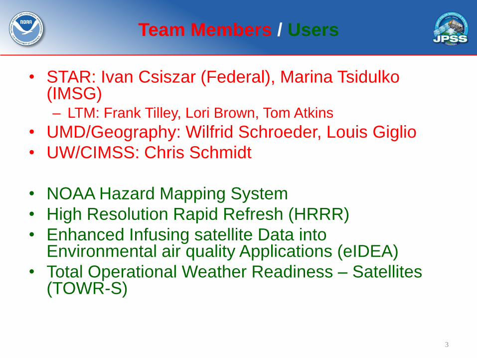
• STAR: Ivan Csiszar (Federal), Marina Tsidulko (IMSG) – LTM: Frank Tilley, Lori Brown, Tom Atkins
• UMD/Geography: Wilfrid Schroeder, Louis Giglio
• UW/CIMSS: Chris Schmidt
• NOAA Hazard Mapping System
• High Resolution Rapid Refresh (HRRR)
• Enhanced Infusing satellite Data into Environmental air quality Applications (eIDEA)
• Total Operational Weather Readiness – Satellites (TOWR-S)
3
Team Members / Users
4
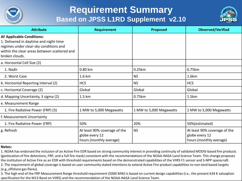
Requirement Summary Based on JPSS L1RD Supplement v2.10
Attribute Requirement Proposed Observed/Verified
AF Applicable Conditions: 1. Delivered in daytime and night-time regimes under clear-sky conditions and within the clear areas between scattered and broken clouds.
a. Horizontal Cell Size (2)
1. Nadir 0.80 km 0.25km 0.75km
2. Worst Case 1.6 km NS 1.6km
b. Horizontal Reporting Interval (2) HCS NS HCS
c. Horizontal Coverage (2) Global Global Global
d. Mapping Uncertainty, 3 sigma (2) 1.5 km 0.75km 1.5km
e. Measurement Range
1. Fire Radiative Power (FRP) (3) 1 MW to 5,000 Megawatts 1 MW to 5,000 Megawatts 1 MW to 5,000 Megawatts
f. Measurement Uncertainty
1. Fire Radiative Power (FRP) 50% 20% 50%(estimated)
g. Refresh At least 90% coverage of the globe every 12 hours (monthly average)
NS At least 90% coverage of the globe every 12 hours (monthly average)
Notes: 1. NOAA has endorsed the inclusion of an Active Fire EDR based on strong community interest in providing continuity of validated MODIS-based fire products (geolocation of fire detections, FRP, and a full fire mask) consistent with the recommendations of the NOAA-NASA Land Science Team. This change proposes the institution of Active Fire as an EDR with threshold requirements based on the demonstrated capabilities of the VIIRS F1 sensor and S-NPP spacecraft. 2. The requirement of global coverage is based on user community stated intentions to extend Active Fire product capabilities to non-land based targets (e.g.,offshore gas flares). 3. The high end of the FRP Measurement Range threshold requirement (5000 MW) is based on current design capabilities (i.e., the present 634 K saturation specification for the M13 Band on VIIRS) and the recommendation of the NOAA-NASA Land Science Team.

Four years of the IDPS VIIRS fire product from the NOAA NESDIS STAR long-term monitoring system
https://www.star.nesdis.noaa.gov/jpss/EDRs/products_activeFires.php
5
Examples of the operational real-time IDPS product as archived in NOAA CLASS. Not reprocessed; not to be used for science analysis. Product history demonstration only.
Preparations for reprocessing are ongoing.
No spurious scanlines were found in 2015 in the IDPS VIIRS Active Fire product. This is the result of improvements in the input SDR processing in IDPS.
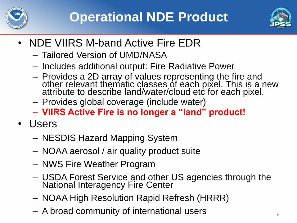
• NDE VIIRS M-band Active Fire EDR – Tailored Version of UMD/NASA
– Includes additional output: Fire Radiative Power (FRP) – Provides a 2D array of values representing the fire and
other relevant thematic classes of each pixel. This is a new attribute to describe land/water/cloud etc for each pixel.
– Provides global coverage (include water) – VIIRS Active Fire is no longer a “land” product!
• Users
– NESDIS Hazard Mapping System
– NOAA aerosol / air quality product suite
– NWS Fire Weather Program
– USDA Forest Service and other US agencies through the National Interagency Fire Center
– NOAA High Resolution Rapid Refresh (HRRR)
– A broad community of international users 6
Operational NDE Product
7
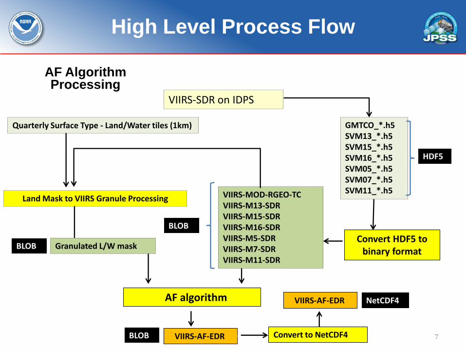
High Level Process Flow
HDF5
Convert HDF5 to binary format
GMTCO_*.h5 SVM13_*.h5 SVM15_*.h5 SVM16_*.h5 SVM05_*.h5 SVM07_*.h5 SVM11_*.h5 VIIRS-MOD-RGEO-TC
VIIRS-M13-SDR VIIRS-M15-SDR VIIRS-M16-SDR VIIRS-M5-SDR VIIRS-M7-SDR VIIRS-M11-SDR
AF algorithm
Land Mask to VIIRS Granule Processing
VIIRS-SDR on IDPS
BLOB
VIIRS-AF-EDR Convert to NetCDF4
NetCDF4
AF Algorithm Processing
VIIRS-AF-EDR
BLOB
Quarterly Surface Type - Land/Water tiles (1km)
Granulated L/W mask BLOB
8
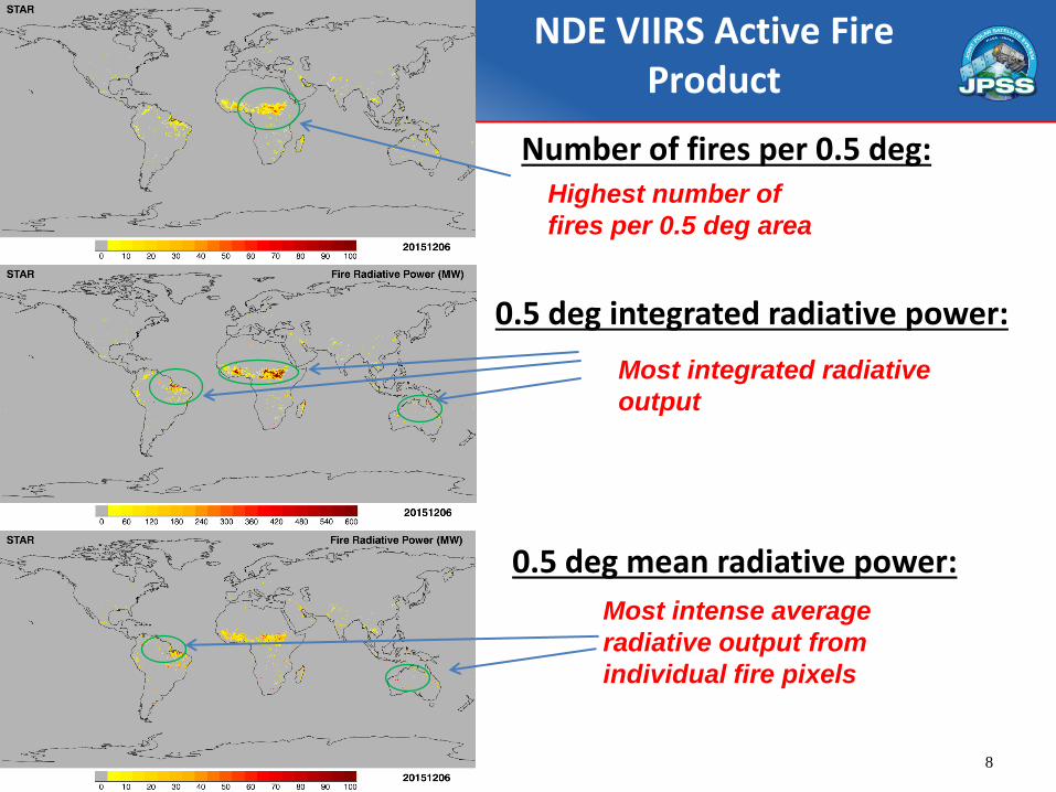
Number of fires per 0.5 deg:
0.5 deg integrated radiative power:
Highest number of
fires per 0.5 deg area
Most integrated radiative
output
NDE VIIRS Active Fire Product
0.5 deg mean radiative power:
Most intense average
radiative output from
individual fire pixels
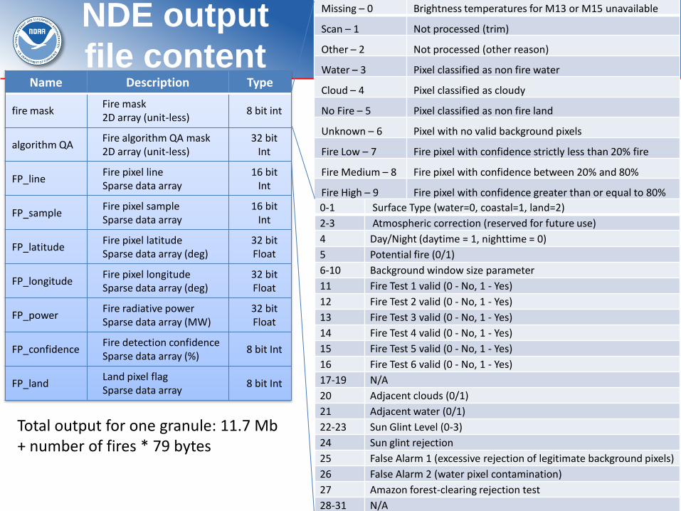
NDE output
file content
Total output for one granule: 11.7 Mb + number of fires * 79 bytes
Name Description Type
fire mask Fire mask 2D array (unit-less)
8 bit int
algorithm QA Fire algorithm QA mask 2D array (unit-less)
32 bit Int
FP_line Fire pixel line Sparse data array
16 bit Int
FP_sample Fire pixel sample Sparse data array
16 bit Int
FP_latitude Fire pixel latitude Sparse data array (deg)
32 bit Float
FP_longitude Fire pixel longitude Sparse data array (deg)
32 bit Float
FP_power Fire radiative power Sparse data array (MW)
32 bit Float
FP_confidence Fire detection confidence Sparse data array (%)
8 bit Int
FP_land Land pixel flag Sparse data array
8 bit Int
9
Missing – 0 Brightness temperatures for M13 or M15 unavailable
Scan – 1 Not processed (trim)
Other – 2 Not processed (other reason)
Water – 3 Pixel classified as non fire water
Cloud – 4 Pixel classified as cloudy
No Fire – 5 Pixel classified as non fire land
Unknown – 6 Pixel with no valid background pixels
Fire Low – 7 Fire pixel with confidence strictly less than 20% fire
Fire Medium – 8 Fire pixel with confidence between 20% and 80%
Fire High – 9 Fire pixel with confidence greater than or equal to 80%
0-1 Surface Type (water=0, coastal=1, land=2)
2-3 Atmospheric correction (reserved for future use)
4 Day/Night (daytime = 1, nighttime = 0)
5 Potential fire (0/1)
6-10 Background window size parameter
11 Fire Test 1 valid (0 - No, 1 - Yes)
12 Fire Test 2 valid (0 - No, 1 - Yes)
13 Fire Test 3 valid (0 - No, 1 - Yes)
14 Fire Test 4 valid (0 - No, 1 - Yes)
15 Fire Test 5 valid (0 - No, 1 - Yes)
16 Fire Test 6 valid (0 - No, 1 - Yes)
17-19 N/A
20 Adjacent clouds (0/1)
21 Adjacent water (0/1)
22-23 Sun Glint Level (0-3)
24 Sun glint rejection
25 False Alarm 1 (excessive rejection of legitimate background pixels)
26 False Alarm 2 (water pixel contamination)
27 Amazon forest-clearing rejection test
28-31 N/A

VIIRS fire mask over NW Canada 5/29/2015 20:06 UTC
clouds water
clear land
fires
VIIRS fire mask generated at NOAA/NESDIS/STAR from IDPS input data. The NOAA Level-2 product is consistent with the corresponding NASA science product
NDE VIIRS Active Fire Product: Fire Mask
FRP: 4.9 – 1257.5 MW
(daytime)

11
clouds
clear land (no fire)
water fires
Fires in Australia on December 1, 2015
Characterizing Fires: confidence and radiative power
• Continuing long-term science monitoring – Product was incorporated into the STAR LTM system
within two weeks of operational transition • Offline monitoring started immediately
• Implementation of J1 cal/val plan – Independent reference data
– Correlative analysis with compatible products
• Detection performance – Probability of detection as a function of fire characteristics
– Omission / commission rates • Need definition of “fire”!
• FRP – retrieval accuracy against reference measurements
12
Testing and Validation

| Page 13
VIIRS Fire in the STAR LTM system https://www.star.nesdis.noaa.gov/jpss/EDRs/products_activeFires.php
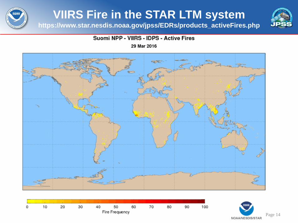
| Page 14
VIIRS Fire in the STAR LTM system https://www.star.nesdis.noaa.gov/jpss/EDRs/products_activeFires.php

• NDE implementation was nearly seamless
• Easy access to global near-real-time data from NDE to SCDR
• NDE does not process repaired granules, which impacts the data record
• CLASS archival did not start immediately
– Discussions on metadata details etc.
• Very strong interest from key NOAA operational users
| Page 15
Lessons Learned
• Strong dependency on SDR performance and
product content
– fire detection / characterization is a very unique
problem due to at least two reasons:
• 1. the target variable is sub-pixel and
• 2. the radiometric signal is at the high end of the
dynamic range for many channels used which results in
sensor-specific artifacts and necessary corrections.
• Implementation of a generalized enterprise
solution is deemed to be (nearly) impossible for
all practical purposes
16
Risks and Review Items

The Alternative 375m Fire Algorithm
• Takes advantage of the higher resolution VIIRS bands – Simple adaptation of MODIS C6 algorithm produced poor
results • Widespread commission errors
• Data artifacts affecting channel I4 (MIR driving the fire detection)
Frequent data saturation and folding causing omission errors
South Atlantic Magnetic Anomaly (SAMA) causing large number of spurious detections
– Custom algorithm developed • Tuning of all tests used in the algorithm
• Development of several additional tests in order to deal with data artifacts
Two-stage analysis of daytime fire pixels
Special module to deal with SAMA affecting nighttime pixels

Fire Detection Metrics
(3-month sample)
Unique 375 m (750 m) fire pixels describe those cases without coincident 750 m (375 m) detection (including adjacent pixels)
Larger percentage of unique 375 m nighttime fire pixels caused by
diurnal cycle (smaller/lower intensity night fires) and – to a less extent – pending 750 m algorithm tuning
VIIRS Fire Algorithm Optimization
• Latest version of 375 m algorithm incorporates several modifications
– Hybrid algorithm using both I and M-band data
• Using I4&I5 brightness temp and quality flag data to identify pixel saturation and folding
• Using I4&M13 (un-aggregated) channel test to identify spurious detections due to South Atlantic Magnetic anomaly
• Using M13 (aggregated) channel to derive FRP
Downscaling of M13 pixel to I-band resolution
• Using combination of internal/external land-water pixel classification scheme to avoid false alarms along coastlines
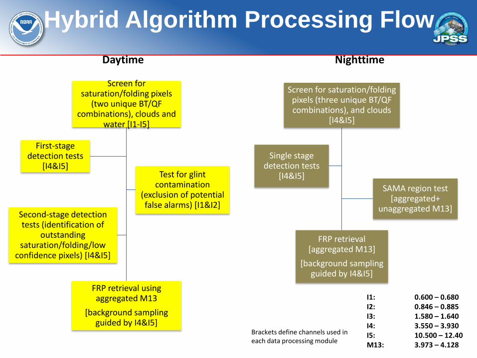
Hybrid Algorithm Processing Flow
Screen for saturation/folding pixels (three unique BT/QF combinations), and clouds
[I4&I5]
FRP retrieval [aggregated M13]
[background sampling guided by I4&I5]
Single stage detection tests
[I4&I5]
SAMA region test [aggregated+
unaggregated M13]
Screen for saturation/folding pixels
(two unique BT/QF combinations), clouds and
water [I1-I5]
FRP retrieval using aggregated M13
[background sampling guided by I4&I5]
First-stage detection tests
[I4&I5] Test for glint
contamination (exclusion of potential false alarms) [I1&I2]
Second-stage detection tests (identification of
outstanding saturation/folding/low
confidence pixels) [I4&I5]
Daytime Nighttime
I1: 0.600 – 0.680 I2: 0.846 – 0.885 I3: 1.580 – 1.640 I4: 3.550 – 3.930 I5: 10.500 – 12.40 M13: 3.973 – 4.128
Brackets define channels used in each data processing module
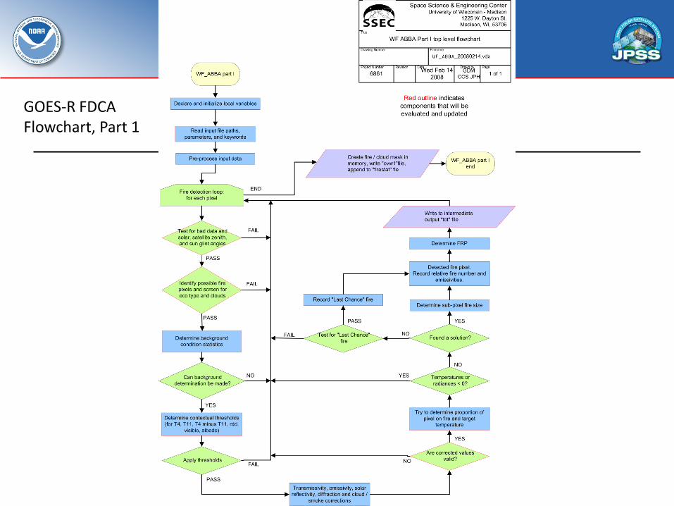
GOES-R FDCA Flowchart, Part 1

GOES-R FDCA Flowchart, Part 2
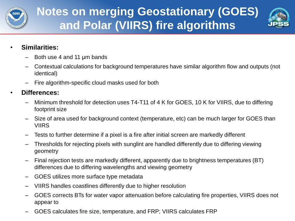
Notes on merging Geostationary (GOES)
and Polar (VIIRS) fire algorithms
• Similarities:
– Both use 4 and 11 μm bands
– Contextual calculations for background temperatures have similar algorithm flow and outputs (not
identical)
– Fire algorithm-specific cloud masks used for both
• Differences:
– Minimum threshold for detection uses T4-T11 of 4 K for GOES, 10 K for VIIRS, due to differing
footprint size
– Size of area used for background context (temperature, etc) can be much larger for GOES than
VIIRS
– Tests to further determine if a pixel is a fire after initial screen are markedly different
– Thresholds for rejecting pixels with sunglint are handled differently due to differing viewing
geometry
– Final rejection tests are markedly different, apparently due to brightness temperatures (BT)
differences due to differing wavelengths and viewing geometry
– GOES utilizes more surface type metadata
– VIIRS handles coastlines differently due to higher resolution
– GOES corrects BTs for water vapor attenuation before calculating fire properties, VIIRS does not
appear to
– GOES calculates fire size, temperature, and FRP; VIIRS calculates FRP
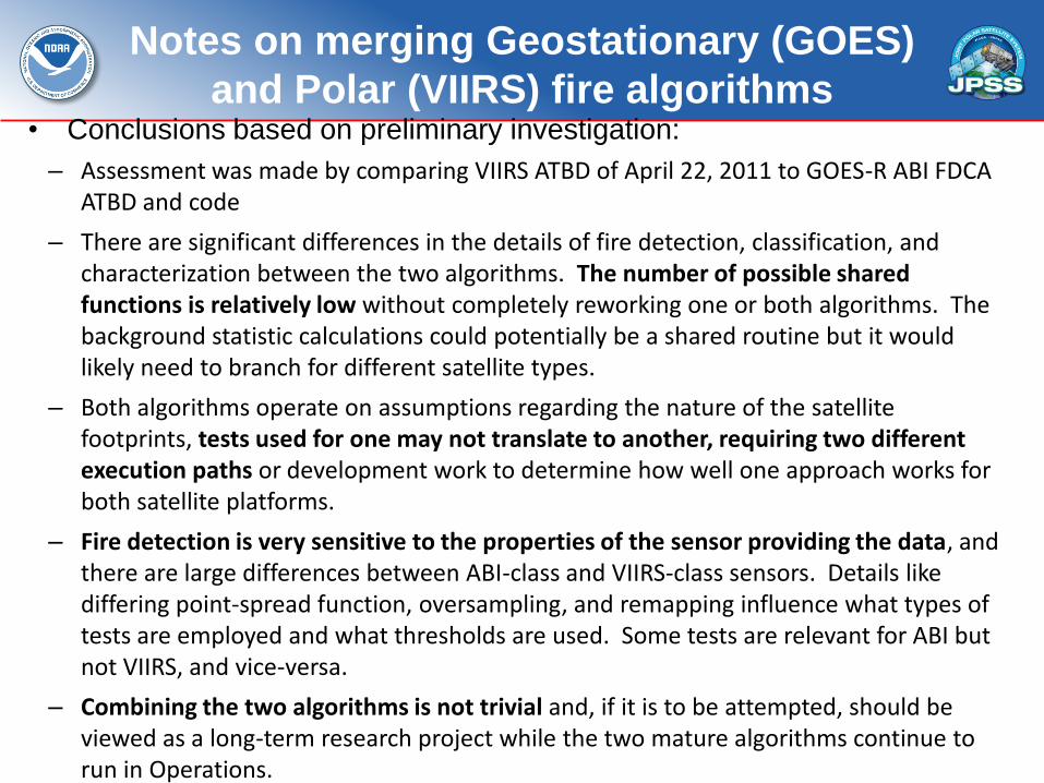
Notes on merging Geostationary (GOES)
and Polar (VIIRS) fire algorithms • Conclusions based on preliminary investigation:
– Assessment was made by comparing VIIRS ATBD of April 22, 2011 to GOES-R ABI FDCA ATBD and code
– There are significant differences in the details of fire detection, classification, and characterization between the two algorithms. The number of possible shared functions is relatively low without completely reworking one or both algorithms. The background statistic calculations could potentially be a shared routine but it would likely need to branch for different satellite types.
– Both algorithms operate on assumptions regarding the nature of the satellite footprints, tests used for one may not translate to another, requiring two different execution paths or development work to determine how well one approach works for both satellite platforms.
– Fire detection is very sensitive to the properties of the sensor providing the data, and there are large differences between ABI-class and VIIRS-class sensors. Details like differing point-spread function, oversampling, and remapping influence what types of tests are employed and what thresholds are used. Some tests are relevant for ABI but not VIIRS, and vice-versa.
– Combining the two algorithms is not trivial and, if it is to be attempted, should be viewed as a long-term research project while the two mature algorithms continue to run in Operations.
Conclusion
• M-band algorithm is in operations
• I-band / hybrid product – The occurrence of frequent I-band data artifacts
(saturation/folding/SAMA) require the adoption of unique pre-/post-screening of data
– Use of both I and M-band data create additional VIIRS-specific data handling/processing compared to MODIS, GOES/-R fire algorithms
– Hybrid I-M band algorithm could replace current baseline (750m) algorithm • Improved detection of small fires, mapping of large fires
• Improved FRP retrievals due to enhanced background sampling used in calculations
• Reduced VIIRS fire data redundancy/confusion
• VIIRS / ABI common algorithm is a significant challenge
• Recommendations – Ensure immediate data archival and long-term monitoring
• Any generic archival / metadata issues?
– Implement I-band / hybrid I-M band product(s) in NOAA operations
– Backfill repaired granules in operational stream
– Reprocess once all SDR / AF interface / QF issues are resolved
– Continue detailed comparative assessment of polar and geostationary algorithms • a long-term research activity, not ready for implementation
• Outstanding issues – Fire detection / characterization is a very unique problem
due to at least two reasons: • 1. the target variable is sub-pixel and
• 2. the radiometric signal is at the high end of the dynamic range for many channels used which results in sensor-specific artifacts and necessary corrections. 26
Summary