Embed Size (px)
Citation preview

J. It , lA-Oi 6C,-J(
t- -i. ^*- S"
C-*- /V*? Vv-
MlY.5
42A12SE8366 2.8103 JAMIESON 010
REPORT ON OVERBURDEN DRILLING
AND GEOCHEMICAL RESULTS
JA-JE PROJECT
JAMIESON TOWNSHIP PORCUPINE MINING DIVISION
ONTARIO
BY
DRI7PIELD CAMERON
ASARCO EXPLORATION COMPANY OF CANADA LIMITED
TORONTO,- ONTARIO '
MARCH 1976
REPORT ON OVERBURDEN DRILLING
AND GEOCHEMICAL RESULTS
JA-JE PROJECT
1. INTRODUCTION
Following a geologic and geophysical compilation of Jamieson Twp., Ontario in 1975 by Mr. R. S. Gray, of Asarco Exploration Company of Canaela Limited, 70 contiguous claims were staked in an area bordering on the northern boundary of Godfrey Township. Thirteen overburden drill hole sites were selected at 1500 foot intervals along two east-west lines. Bradley Brothers Limited was chosen to drill the holes using a reverse circulation rig mounted on the back of a dual tracked Nodwell. The drilling was accomplished during February 1976, with samples of various overburden units being taken and analyzed for copper, zinc,lead, and silver.
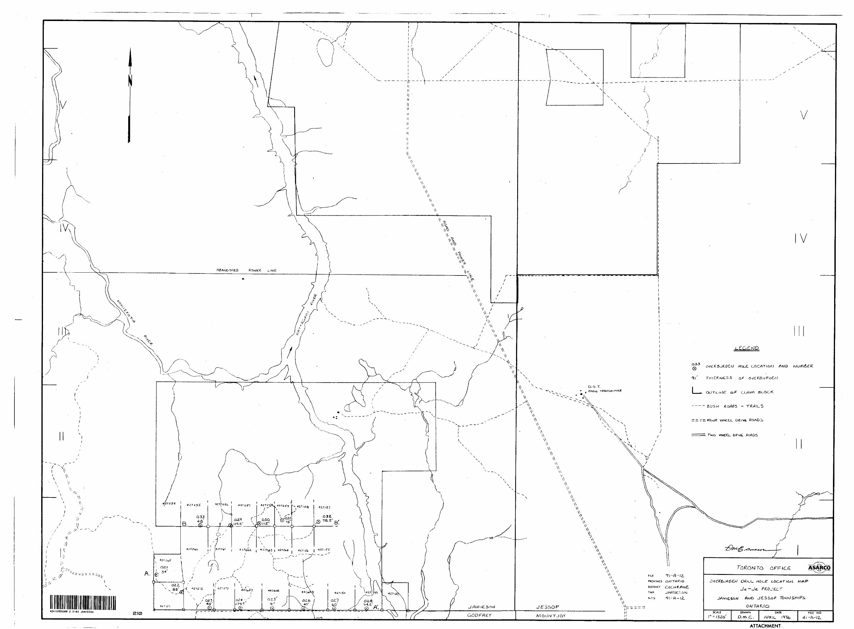
2. LOCATION AND ACCESS
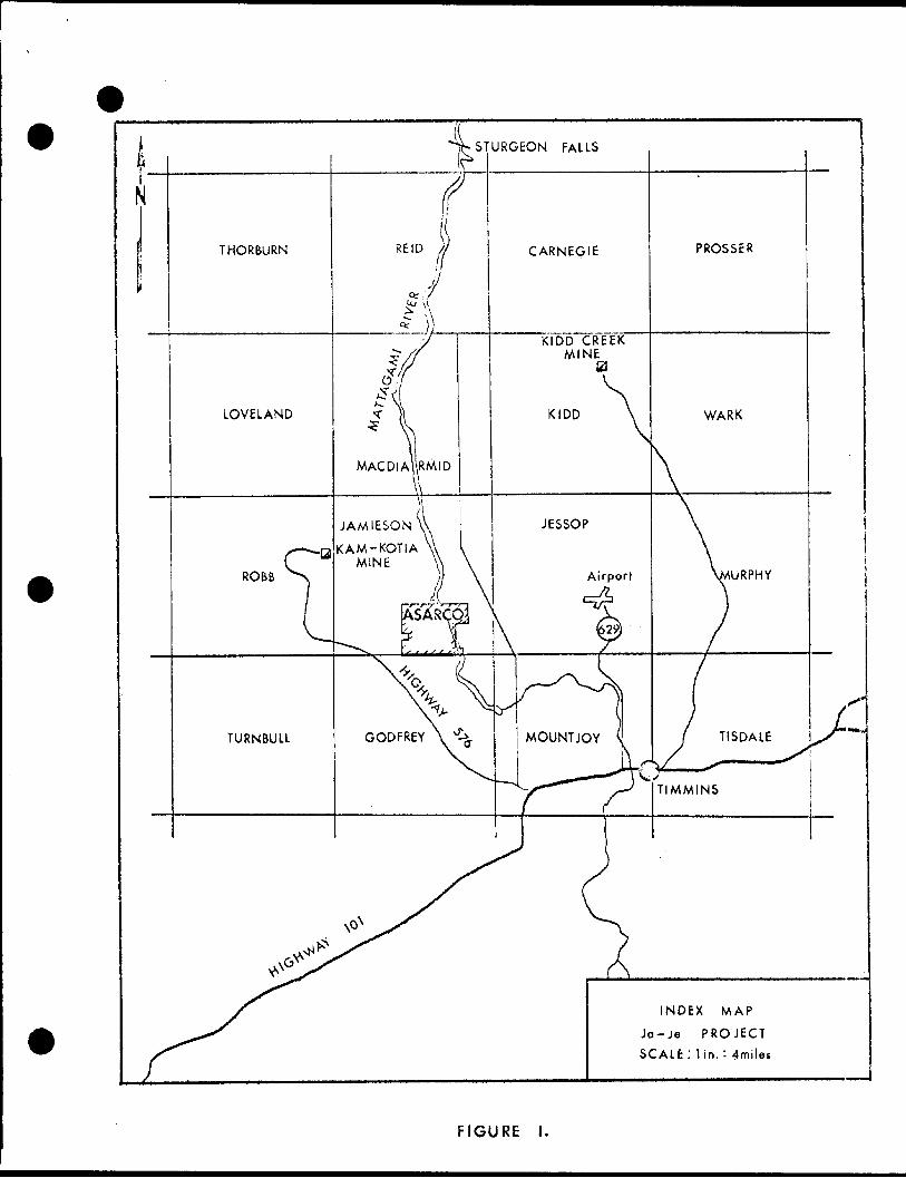
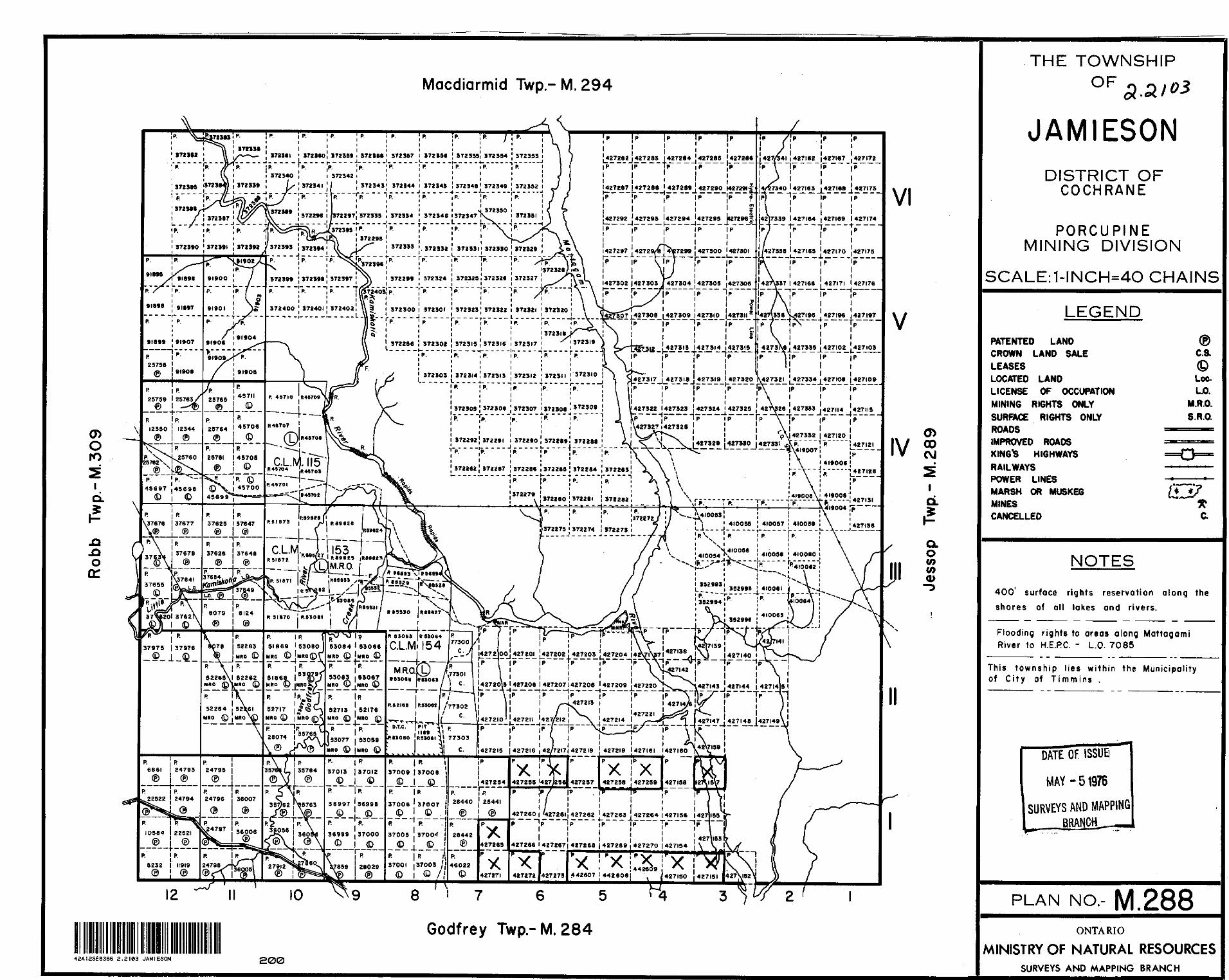
During 1975, Asarco Exploration Company of Canada staked 70 contig uous claims in the southern portion of Jamieson Township in Ranges I, II and III (see figure 1).
Jamieson Township is located approximately seven miles west north west of the intersection of Highways 101 and 629 in Timmins. Access to the property from this junction is westerly along Highway 101 for 4.4 miles to Highway 576 (Kam-Kotia Road), and then 6.4 miles in a northwesterly direction along Highway 576 to a bush road on the northeast side of the Highway. The Jamieson-Godfrey Township line (the south boundary of the claim block) is reached by travelling about 1.5 miles on the bush road, which can be accomplished by snow mobile or snowshoe in winter or by foot in summer.
CLAIM NUMBERS
The 70 claims on which the overburden drilling and sample analysis will be applied as assessment work-are:
INDEX M AP
Ja-Je PROJECT
SCALE : lin, : 4miles
FIGURE
-2-
P427137 - P427161 (inclusive) 25 claimsP427200 - P427221 (inclusive) 22 claimsP427254 - P427273 (inclusive) 20 claimsP442607 - P442609 (inclusive) 3 claims
4. TOPOGRAPHY AND VEGETATION
A fairly broad north-south trending ridge is located along the western boundary of the claim block; overburden holes 021, 022 and 033 are located on the eastern flank of this low topographic feature. The remainder of the land surface to the Mattagami River on the east is flat, except for stream valleys where tributaries of the Matta gami have eroded channels; occasional alder swamps are located in this area.
Overburden holes 021, 022 and 033 are located in an area of mainly poplar and birch trees; a stand of jack pine occurs close to holes 021 and 022. The remaining holes, 023 to 028. of the south fence are in predominantly coniferous bush (spruce and fir) with infrequent to frequent birch, poplar, and alders. Holes 029 to 032.of the north fence are surrounded mainly by deciduous growth (poplar, alders, and birch) with infrequent to frequent fir and spruce, and very infrequent cedar.
*
5. PREVIOUS WORK
Ground geophysical surveys over a portion of the Asarco claim block have been carried out and recorded with the government by Hollinger "ines Limited, E. Jutila ("ount Jamie Mines Limited), G. Milner (Northern Exploration Limited-Kelly Desmond Mining Limited), Porcupine Paymaster Limited (Hollinger Mines Limited),and Mespi Mines Limited. The area has been covered c number of times with airborne electro magnetic and magnetometer surveys - the most recently recorded time being in 1971 by Newmont Exploration Company. Also, about 20 diamond drill holes have been completed, in this southeastern portion of Jamieson Township.

-3-
rDespite this considerable amount of previously accomplished work,
it was concluded that mis-oriented grid lines, undrilled airborne
electromagnetic conductors, and the overburden thickness and
character presented a viable opportunity for an overburden drill
program.
6. DRILLING EQUIPMENT AND SUPPORT VEHICLES
The overburden drill was a Longyear L-38 drill which had been modified
for reverse circulation drilling and which was driven by a three
cylinder Detroit Diesel Motor. The drill had a two foot stroke and
could handle 20 feet of rods above the head. The derrick was
numbered to show depth in hole of each individual stand of rods,
and was hinged and lowered hydraulically before moving between
holes. The drill was mounted on the back of an 18 ton diesel FN 160
Flextrac Nodwell (dual tracked) and was surrounded by a removable,
partially insulated plywood drill shack. A 400 gallon water tank
on the back of this Nodwell served as a resevoir for the drilling
water and caught the water return from the hole. Water was carried
to the drill in a cylindrical 500 gallon tank which was mounted on
the back of diesel FN60 Canadair Flextrac (dual tracked).
Drill roads were broken by the FNGO Canadair Flextrac and by a
diesel Bombardier Muskeg hired specifically for this purpose. Gen
erally two men with chain saws worked with the machines on the road
making.
The drilling contract was awarded to Bradley Brothers Limited, Noranda and was handled out of their Timmins office.
7. METHOD OF DRILLING AND SAMPLING
The overburden drill holes were sunk using reverse circulation with
water as the drilling fluid. Each drill rod consisted of two con
centric pipes. Water was pumped down the outer tube, out through three holes in the face of a tricone bit where it picked up and

-4-
carried the overburden with it through the centre of the tricone and up the central tube of the drill rods. From the top of the drill rods the sample passed through a hose and through an 18 inch cyclone to a 10 mesh sieve resting on a large screen over a plastic bucket in which the minus 10 mesh fraction of -the sample collected before the water flowed from the bucket into the water tank to be re-used
The plus 10 mesh fraction was included in the sample from tills, bedrock, and locally derived gravels. The minus 10 mesh fraction collected in the bottom of the bucket and a representative portion of it was included in, and made the majority of, each sample. Samples were collected over a maximum interval of 10 feet in the upper sampled sections of the hole, while close to bedrock a five foot sample was preferred. Samples were not taken across lithologic boundaries.
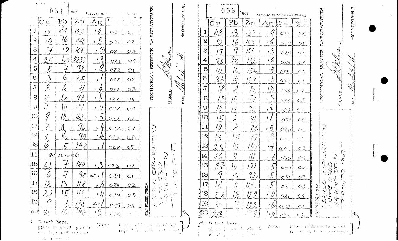
A sample averaging about 15 pounds was taken if sufficient return was available, placed in a cloth sample bag, a number of which were in turn packed in larger cloth bags and shipped by rail to S.A. Averill in Ottawa for drying, sieving, tabling, and production of a non-magnetic heavy mineral concentrate. This concentrate was then analyzed by Bondar-Clegg and Company of Ottawa for copper, lead, zinc and gold.
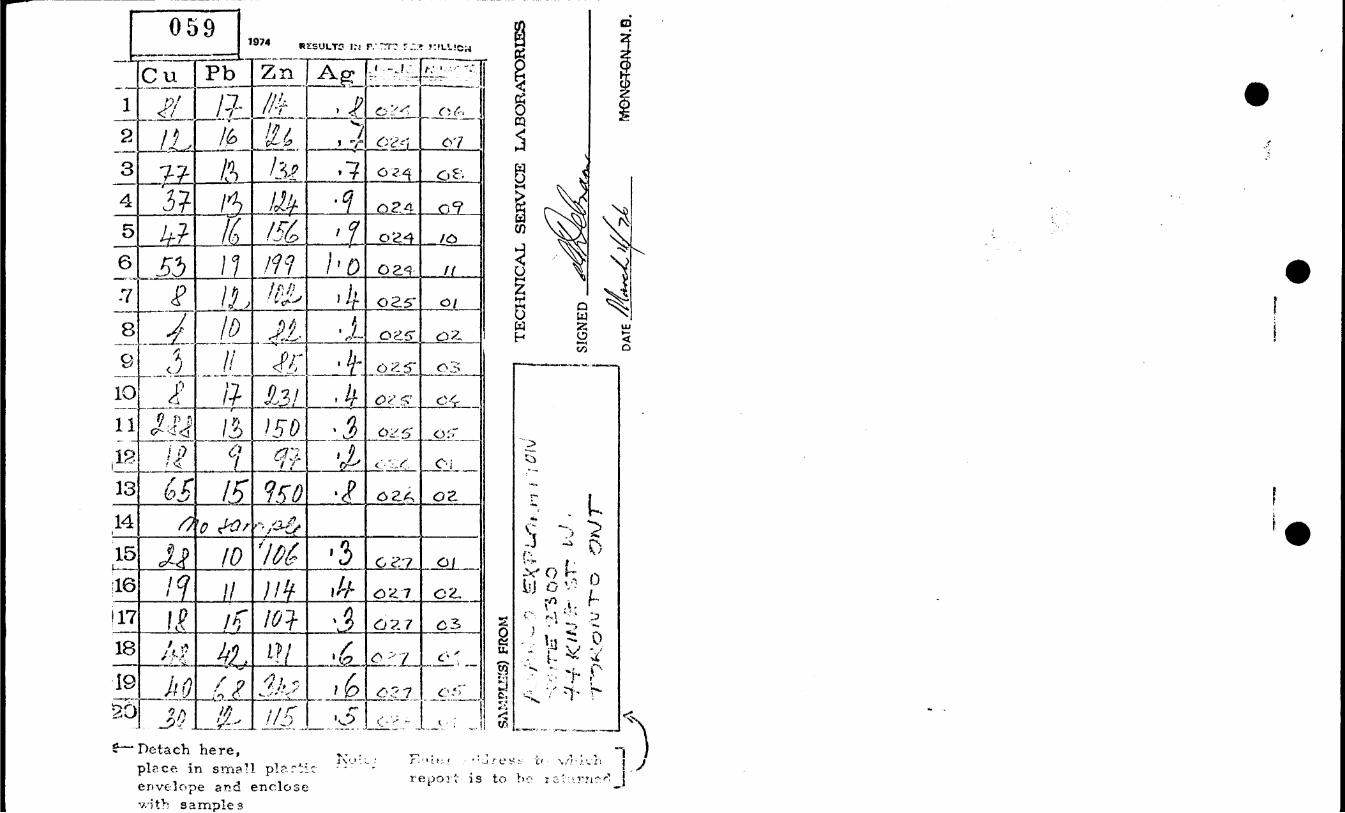
From each sample was taken a small grab sample to be analyzed geochemically for copper, lead, zinc and silver by Technical Service Laboratories in Toronto. These analyses serve as a comparison with the results of the heavy mineral concentrate analyses, and may provide more quickly an indication of an anomalous condition.
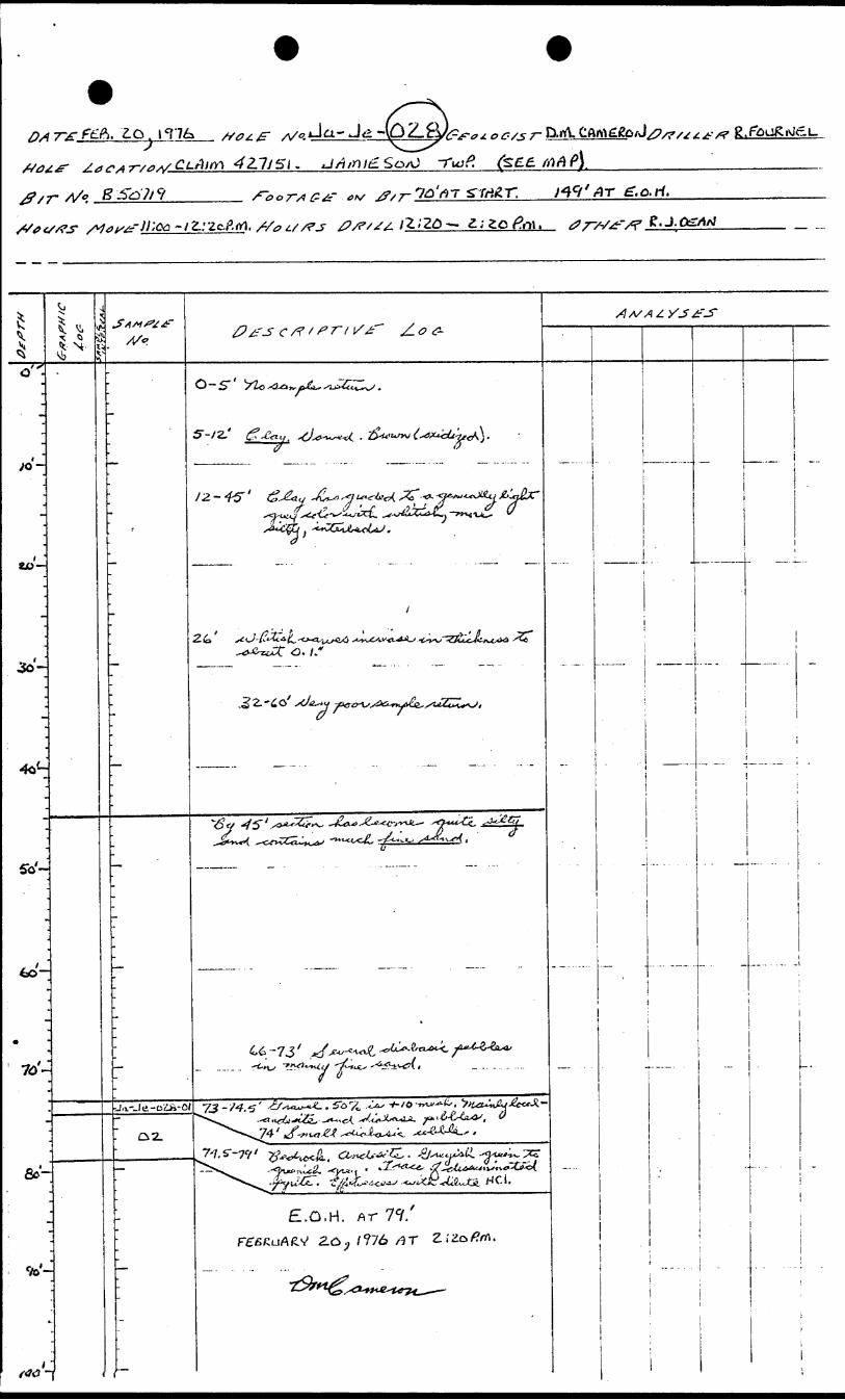
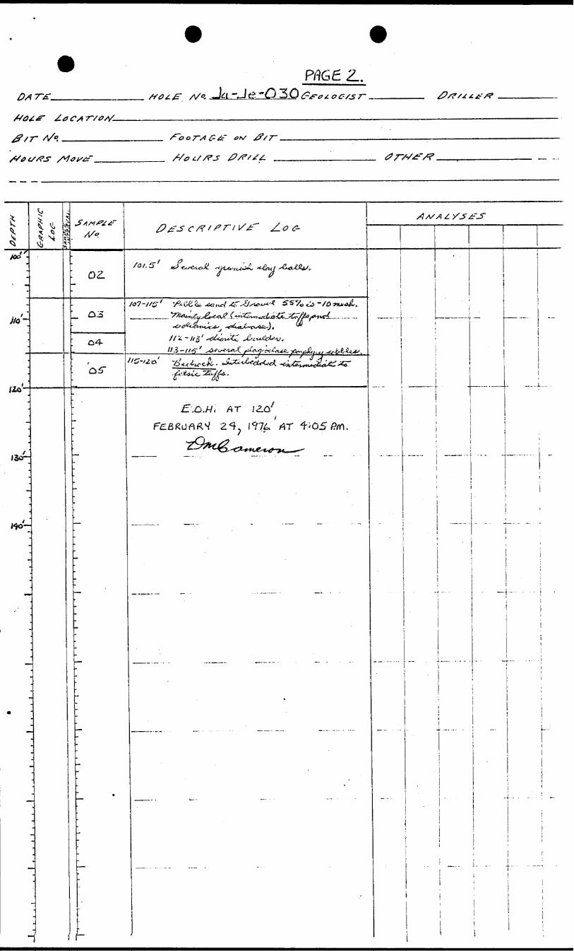
8. SAMPLE LOGGING
A continuous log of the overburden return was raade by the geologist as each hole was being drilled. Lithologies and the presence of sulfides were of primary concern, but sample size, pebble to boulder types, drilling times, sample descriptions and lengths, et cetra,
-5-
all included in the logs. (see appendix 2 for logs).
9. ANALYSIS AND PREPARATION OF SAMPLES
The samples (59) for geochemical analysis were dried, sieved to
minus 80 mesh, and analysed using atomic absorbtion (aqua regia extraction) for copper, lead, zinc, and silver by Technical Service Laboratories (see appended certificates of analysis, Appendix 3).
The analytical results and the method of preparation of the heavy mineral concentrate derived from the bulk of the collected sample
will not be included in this report. A portion of this split will be retained for possible further testing and for binocular micro scope examination.
10. OVERBURDEN GEOCHEMICAL RESULTS
The cumulative percentage of frequency of occurrence of the values was plotted on logarithmic probability paper to define the anoma lous resutls.
Of the 45 overburden samples analyzed geochemically for copper,
lead, zinc and silver, three samples were anomalous in copper, one was anomalous in zinc, and one was anomalous in lead. No more
than one of these high values came from the same sample.
Copper values from Hole 24, samples 06 and 08 (81 p*.p.m., and 77 p.p.m) and from Hole 030, sample 04 (86 p.p.m.) were distinctly
anomalous over a population having 19.4 p.p.m. as its mean. The standard deviation was calculated to be 20.5 p.p.m. Hole 024 with the two anomalous copper values was down ice from Hole 030, which
had the third anomalous value. In the case of the latter, the sample(from the three feet immediately above bedrock) came from a pebble sand-gravel in which 555 of the sample was -10 mesh and in which the majority of the +10 mesh material was of "local" deviation; within this sample interval was a one foot diorite boulder (coarse fraction discarded) and two feet which contained several small plagioclase porphyry boulders. The anomalous

samples from hole 024 came from the basal unit of the overburden, but were neither basal samples nor consecutive samples in the hole.
The unit was a gravel consisting of approximately 65?; +10 mesh material. Sample 06 (eight feet) from 132'-14O" contained a mix ture of "foreign" and "local" pebbles and cobbles? at 131', immediately preceding this sample was a small siliceous volcanic cobble which contained S-7% disseminated pyrite; at 140' was a small grey coloured rhyolite cobble. Sample 08 (ten feet) from 150'-160' contained mainly "local" pebbles (metasediments, inter mediate volcanics, diabase, with dolomite pebbles becoming smaller and fewer than above); at 151' was a small diabase cobble ; and from 155'-160' were frequent cobbles of diabase and intermediate and felsic volcanics. The two anomalous copper values are 24 p.p.m. and 28 p.p.m. higher than the underlying bedrock (andesite tuff).
The one anomalous zinc value (231 p.p.m.) which came from hole 025, sample 04 (three feet from 79.5'-82.5') came from the top of a boulder rich section which lay immediately on bedrock. Two feet were mainly gravel and one foot came from a more clay rich, though gravelly, section. Not enough nonboulder material was obtained from Mower in this section to constitute a sample. This high zinc value came from the nearest hole to the east (1500* hole sep aration) of hole 024 which contained the two anomalous copper samples, but there was no anomalous zinc expression up-ice. It should be noted that the anomalous zinc sample is 81 p.p.m. higher than the value obtained in the underlying bedrock (interbedded rhyolite tuff and greywacke).
The single anomalous lead sample of 42 p.p.m. was from hole 027, sample 04 (two feet) from 58'-6O', and appears specious. It is from the base of a mainly local gravel section^immediately above bedrock, which was a small sample because of sample return problems, which may have been contaminated from bedrock, and which has a lead value of 26 p.p-m. less than the underlying bedrock (dacite). No holes were drilled directly up-ice from this hole.

- 7 -
Using a 0.2 p.p.m. class interval and plotting the cumulative percentage of frequence of occurrence on logarithmic probability paper indicated a normal population of silver values.
Average values obtained for the 45 overburden samples are copper-21 p.p.m., lead - 13 p.p.m., zinc - 113.5 p.p.m. and silver - 0.47 p.p.m.
11. BEDROCK GEOCHEMICAL RESULTS
Thirteen bedrock samples were analyzed geochemically. Five samples were rhyolite or rhyolite tuff; five samples were andesite or andesite tuff; and the remaining three smaples were greywacke, dacite, and interbedded intermediate to acid tuffs.
Table l illustrates bedrock values for copper, lead, zinc and silver in parts per million in the various rock type groupings.
Rhyolite-Rhyolite-tuff ____Group_________
21-04
25-05
29-04
32-02
33-05
Andesite-Andesite tuff Group -.
23-02
24-011
26-02
28-02
31-04
TABLE I
Cu. Pb. Zn. Ag. (partsper million)
25
288
14
213
15
40
13
10
16
4
2230
150
154
409
90
0.3
0.3
0.4
1.0
0.1
61
53
65
43
58
7
19
15
13
13
140
199
950
137
122
0.3
1.0
0.8
0.9
1.0

- 8 -
Table I cont,
Cu Pb Zn Ag(parts per ___ Million)
Greywacke
22-09 6 5 148 0.1
Dacite
27-05 40 68 348 0.6
Interbedded intermediate to acid tuffs
30-05 37 10 171 0.5
Statistical analysis of such small groups is not possible, although comparison of individual values to already established averages
for Superior Province rhyolites, dacites, andesites, and basalts will show empiracally anomalous samples.
Bedrock in holes 025 and 032 appears anomalous in copper, as does bedrock when analyzed for zinc in holes 021, 026, 027 and 032. The remaining andesitic to rhyolitic rocks contain normal amounts of copper,but it should be noted that all of the analyses for zinc in this group of rocks gave values at least 50% higher than the average for Superior Province rocks of the same composition. No standards were available for comparison with greywacke or the interbedded intermediate to acid tuffs, although both zinc values are probably higher than average. Lead and silver averages were not considered very reliable, but lead values in holes 021 and 027 are probably anomalous.
12. GEOLOGY
Outcrop is scarce in the eastern ^ne-half and northern one-third of Jamieson Township, but the existing surface exposure, drill hole information, and geophysical data show the township to be

- 9 -
i^fcunderlain by west northwest-east southeast trending Archean mafic to felsic metavolcanics and tuffs with subordinate metasediments which have been intruded by north to north-northwest trending diabase dykes. Minor felsic intrusives and mafic to ultramafic rocks also occur. Two former copper-zinc producers, the Jameland Mine and the Kam-Kotia Mine, are located 2h miles and 3 h miles respectively northeast of the western boundary of Asarco's claim block.
Bedrock drilled during the overburden program of 13 holes con sisted mainly of andesite to rhyolite, both flows and tuffs. One hole encountered a greywacke, and interbedded sediments were found in some of the tuff sections. No economic sulphides were encountered; pyrite varied from nil to 10?; disseminated over two feet.
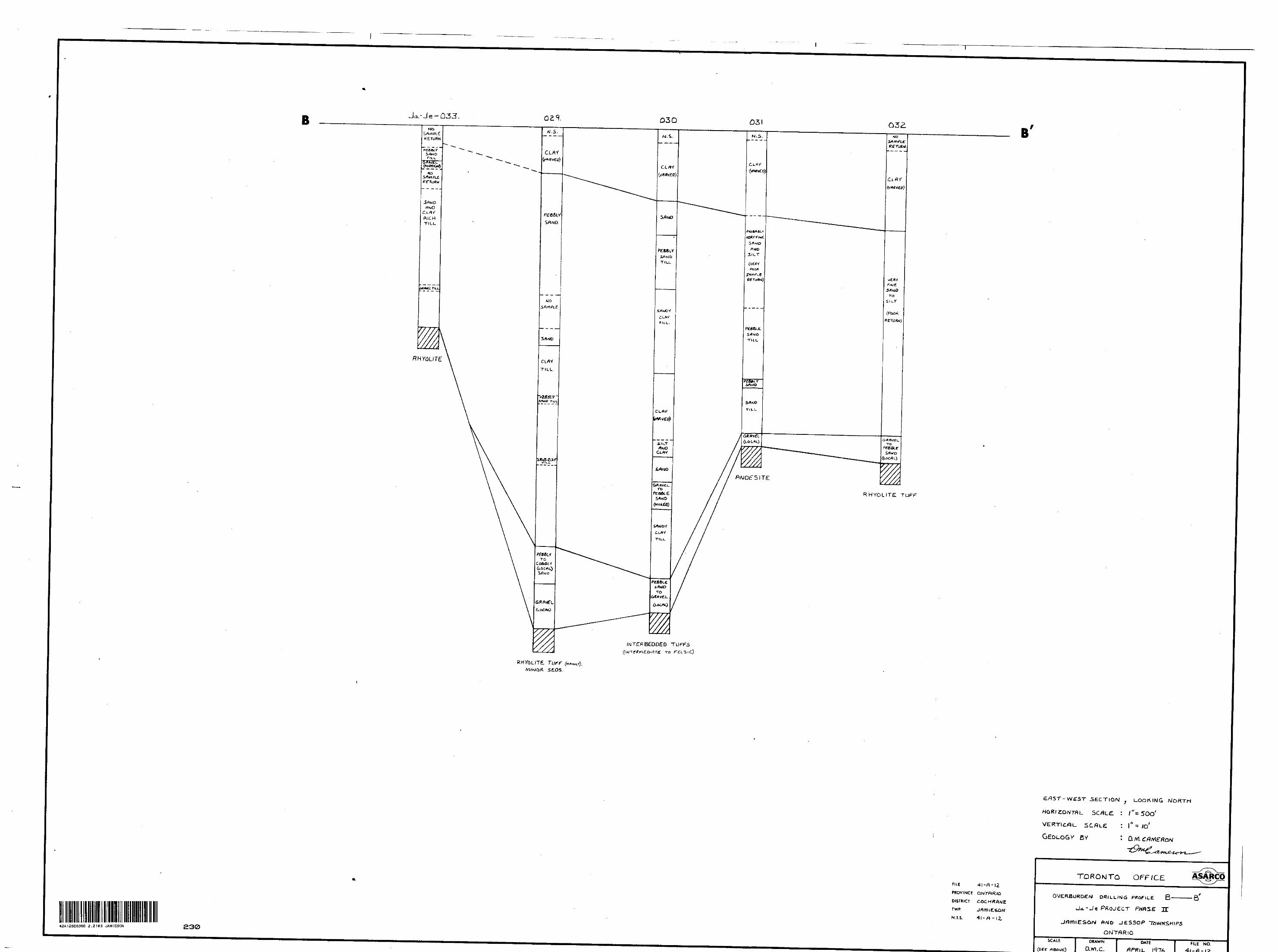
13. PLEISTOCENE GEOLOGY
Two glacial advances are recorded in the overburden drilled in the . deeper holes. The same record is not preserved in the shallower holes because of the scouring or scraping action of a re-advancing glacier or because of an interference to glacial deposition by a paleotopographic feature. The retreated glacier is marked by the formation of generally extensive glaciolacustine sediments.
Most of the till sections in the various holes were sampled, although the sample of the upper tills and the tills with a high predominance of foreign pebbles and cobbles generally were not analyzed. (See appended sections for glacial stratigraphy.)
14. CONCLUSIONS AND RECOMMENDATIONS
In the geochemically analyzed samples, a low anomalous copper train has been identified in the basal "till" (gravel)'section between overburden holes 024 and 030. If this train is substantia ted by the heavy mineral analysis, further overburden drilling will have to be considered to locate the source of the copper

-10-
values. Single anomalous values for zinc and lead were also
found in the overburden of two separate holes.
The anomalous zinc value obtained in the bedrock sample of hole
021 may warrant further follow-up.
APPENDIX 2
GEOCHEMICAL CERTIFICATES OF ANALYSES
APPENDIX 3
OVERBURDEN LOGS
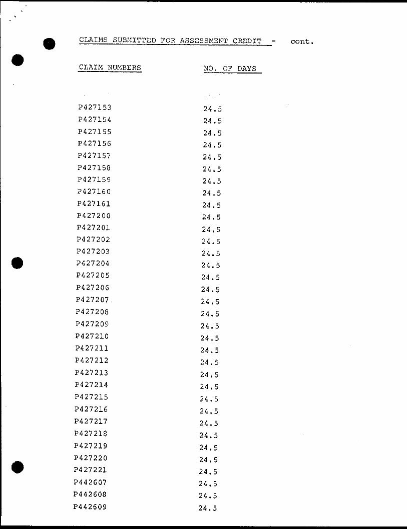
CLAIMS SUBMITTED FOR ASSESSMENT CREDIT - cont,
CLAIM NUMBERS
P427153
P427154
P427155
P427156
P427157
P427158
P427159
P427160
P427161
P427200
P427201
P427202
P427203
P427204
P427205
P42720G
P427207
P427208
P427209
P427210
P427211
P427212
P427213
P427214
P427215
P427216
P427217
P427218
P427219
P427220
P427221
P442607
P442608
P442609
NO. OF DAYS
24.5
24.5
24.5
24.5
24.5
24.5
24.5
24.5
24.5
24.5
24;5
24.5
24.5
24.5
24.5
24.5
24.5
24.5
24.5
24.5
24.5
24.5
24.5
24.5
24.5
24.5
24.5
24.5
24.5
24.5
24.5
24.5
24.5
24.5
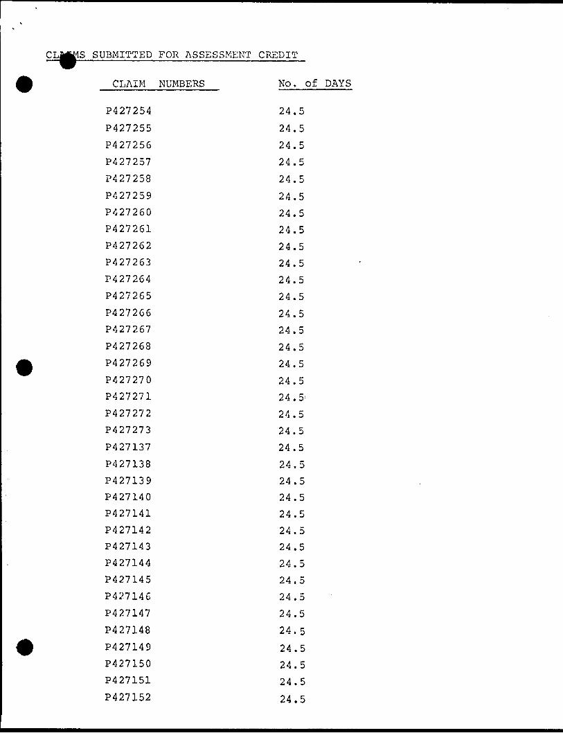
.S SUBMITTED FOR ASSESSMENT CREDIT
CLAIM NUMBERS
P427254
P427255
P427256
P427257
P427258
P427259
P427260
P427261
P427262
P427263
P427264
P427265
P427266
P427267
P427268
P427269
P427270
P427271
P427272
P427273
P427137
P427138
P427139
P427140
P427141
P427142
P427143
P427144
P427145
P427146
P427147
P427148
P427149
P427150
P427151
P427152
No. Of DAYS
24.5
24.5
24.5
24.5
24.5
24.5
24.5
24.5
24.5
24.5
24.5
24.5
24.5
24.5
24.5
24.5
24.5
24. 5 :
24.5
24.5
24.5
24.5
24.5
24.5
24.5
24.5
24.5
24.5
24.5
24.5
24.5
24.5
24.5
24.5
24.5
24.5
-rr ̂
^,;," \ 1
3.L
ij
^
^ 'O u?
i?- ii
i\ x
s; 0 fvJ
W 0 N
,v^
-\"
'
* '
•N *~
r*
(v\
, '
l fR
o;-
' o
- , c
o
ci 3
o -
SAM
P1E5
S) F
ROM
.s-
;
("^is;
:''-
''V
:V
LA '
fVi
0 "0
rv W
OS!
*S\-
W
0 M
\,
CO
^u
rvt*
cs1-
0
\ ^r
^
^ ̂ U
-
v,
J--
!T
EC
HN
ICA
L
SE
RV
ICE
L
A3O
RA
TO
FW
3S
SIG
NED
DA
TE.
HV
5ON
CTO
INH
VJ.O
.
rp f j
' '--
'
;^S
^.. -'
ife^s
' "j- y
.} '.^
e ?
0 W 0 -A0
'Vi
CO e 1^
-,- CO
CO
k -••; iHj? g- L
4:I'.v
i
^^t
o
0) w
lo !
! . :
-f—
t,'-.-^
o io
IK : -i
rt
Srt
\f
\^
.
V.)
t ~
-
^
--'-N
i'c
J
l
b- .'/-
01 a 0 -̂y
"SS
•i -.
- w
CO -Si
CO
' - -
r - -
-
iol!
S-TJ
c^ic
r
CV
•C
'N
c-IV
: ••-C
? !'!';-
y?
SA
MP
LE
S)
F.7.
0M
o l
.^c'
Pv^
o,:;
^^ r
- ...^
V'"
T'-
CO
NIC
AL
S
ER
VIC
E
LA
BO
RA
TO
RT
SS
DA
T;.
"dT n *
iv;t
v-*
CI
CO
CO
O
i- s
?O
'3
tf
O
w
CU
QJ
t.
(D
i-1
O
.T
o, - b
oo"
Is.
7* ON L^
-
0 O
Q •- 0
Ol
?vai c
^ N
SAM
PUK
S) F
RO
M
Q ON
O (M
o ko
i OD
l*
.
0 (M12
!X ;Ac- M
D (X 0 N
!Q -—S)
0
O
-w
0
V
~0
co i
roiO
il
hj
w
cr?
CD
N y
o "Xo
TE
CH
NIC
AL
S
ER
VIC
E
LA
BO
RA
TO
RIE
S
SIG
NED
DATE

4
7Lfe' i'
J5'C? ,S'
3'fC -?. J?
x 'irr -^yy- 9 -^.2: ji-^v- ^r^ fj*2-jr
'jjrp"*"*
j
•29 :
•t?"/X
e- P?; z

t
...u
_j....._,,.. .,. —..;
_ ____— i
, - .
"DZP'"^ fVT^' -j\fi\
l~~t-~jryT/ "** U
'^ C* ^-3* /
'*
s -
90
se?
-t-Q
7v /v y
T'
'((/F w 2I7SJ) ^'""U. (vos 5V Wf r e 1L7L?k
n

-I-T-
Do
LIre
f--
t
k v.S
i e
-1 H
"H**
i kjh
*^1
* x
.-b c r-u
r-
BM
^. .
, r
o
? M.
^ \ -
* f f
'"l
— j^
, _ _
_
__
_____
__i_
_^
-^,.
-
^__ l-
/.of- 15 K
\
l.
^ ^
^ ^ K
•, ^ Pi
tj,
BC D Og
-
pi b i
-
!| S

— AC '
— .
-"*vi-b- --x-x-y- '
Tvsrfo^
- f^rr^f^-'fVf
3-207-

-J-
l
-.-4
'H
p **vv~ 5
"KM* Jy^---^~
f-'--
i
-1
IK?
o
t-
-otl
nc
—OJrf
-o.'/
f
s*o J7-
^70'/y

11.7 E.o.H.
HW S" ~ 3', 43 P.M. g. J.
//o.
o' -
*o -
20-
O -i,'
i'Y.
iS :r JO
-y*
zr 1 36, ' X
L OZ.
-ne,
•7s"'/-ST ^^^,
su^cJi, -^*
j.//T
63-78.
.t,-79. ST' J'-.
2.S"
/,: - rt)/.vi.

^/y.yv^yixCLrtHV\442fcO*?..
2. 24. S ' .0. H .
vb~-s c rt f rrt /.o c-
d .
ac'-
-To'-
t 6oH
7o'H
6-3-4-' SJit.i
r:"" ' d 1 Z. ,
"
34- -fo '
—f 7'
- 02.
e:. c.. H.
— ..

AT c.o.H.
i /V".
o -
20-
3o'H
40-
fco-
70-
1-. -l t'.
, J
25— 4 i'
C i
.O27-OI. •f2 -
-Sl'
O2L
-/O
r 05"
*y'
E.o.H. /qT 70,
1*111 ^7 i
_i..
^
B
D.rt\. C
42.1JSI .
. o. rf.
~- ^; go ^.
/.O C-
o .
So'-
O-S"'
1 2. -45' .^ (l j v
*
E.O.ri. *r 7*?/

PAGE l.25 /v*.
"^ LI 2.6 S. TWP. rvt rtf).
J/o.~ /.o c-
o"-
10 ~
40-
60-
0-2.'
2- li'
jo7
/y -40
-r- /o
-t /to
52.- tot! (f, . 4*1,
6
77''/y - 6^ - -Uf . st^y
4...... . l

/-/o
A/".
/o i" LJ6*t,..*?taeA .^A/^tCL^evfe^td-
,/oS'.
041 '
r a
E.. d. H . rtr /'ZS'
23

'l^ i' J S" - J l .'QQ /3rU. //^ ̂ /e j //.'OO ~ 4}Q5 fifth . . J . Dfcrt A/
s c rt'f•frivf^~ /.o c-
o'"-
eo'n
qo-
O — ̂
3 -17' ft'tt.
•^77;
jri**~trti{sv, TT
-*v-
5X5"- Si'
* ""
2.'.-. 0
03O-OI
-fi t n t Q ''art f. ,*^/!/-, i-"v.., *Jt
j___........ j—-.
-..a.
"/y
J? 3o/V
^ 5V J O 7 0^7.3 Q g- Q^ ^3 JT*- 15T" 'o A'
"Z

ri T
- W5GA.1A . - \Zl\toP.tC\. g. J.
c-
O'-
5o'H
•36-
2-
(7
Ja-Je-
03I-OI
..•*3 •
02.
2.5,^76
l--

42.1)57*0 c
^' TUJJ? &6E. mftp]
g.6'07/7
Z US- 4 Mo . J.
5A/",
c-
o-
lo-
60'-
n.0^- sl&iuA^-j .
C'.-f-CTW .
cue 4?'7
a
j *
;O3Z-OI
02-

. l.. ..^. ___
^
-^f i'}.. -^c-
-j
T*1
~^"(T
1 ii
j
-•3 r- M"*
470-
,i~z
.r -
P ve''t*/
/"m&iryf-,. ,
-pi
09
-0V
07
ot
iP
^ i ^

Ministry ofNaturalResources
LandsAdministratBranch
Ontario
File 2.2103
42A12SE8366 2.21*3 JAMIESON300
Recorded HolderAsarco Exploration Company of Canada
Township or Area
m Trmn ofa "f n
Type of survey and number of Assessment days credit per claim OVERBURDEN DRILLING
GeophysicalElectromagnetic
Magnetometer —
Radiometric ——
Induced polarization .
Section 86 (18) —
Geological ——.—
see across
Geochemical.
.days
.days
.days
.days
.days
.days
.days
Man days l"~l
Special provision O
Airborne LJ
Ground HD
Notice of Intent to be issued:
D Credits have been reduced because of partial coverage of claims.
Q Credits have been reduced because of corrections to work dates and figures of applicant.
[~~l No credits have been allowed for the following mining claims as they were not sufficiently covered by the survey:
Location of (13) Drill Holes 021 to 033
inclusive:
Mining Claims - P. 427150 -51-57
427255 - 56
427258 - 59
427265
427271 - 72
442607 to 09 inclusive
Cost of programme - $25,896.55
Total assessment days credit allowed - 1,726
The above thirteen mining claims may be grouped
under Section 85(6) of The Mining Act, for the
purposes of recording the work credits of
1.726 days.
Approved - December 8, 1976
The Mining Recorder may reduce the above credits if necessary in order that the total number of approved assessment days recorded on each claim does not exceed the maximum allowed as follows: Geophysical — 80; Geological — 40; Geochemical — 40;
828 LA. 101
oK)5
l ci.
-O-Oo o:
Macdiarmid Twp.-M. 294
41 |4^7[6^_|4^7I67_
7540 ' 427163 j 4Z7[SB 427173427287 [427288 427289 1427290 H272W|
7292 '427295 1427294 U27295 Jl2T296| P .P .P IP |p"
-- v~~v—"*P—
427338 '427165 ' 427170
427302 1427303 J 427304 427305
.427309 1427310
427321 [427334 i 427IO8
427322 1427323 427324 427325 4ZTOZB , 4Z7993 . 427114 427115— — — — r ~ ~\—|- —— —-i — — — - --- — P P \ P IP P
427329 427330 (42T33I A P. R- — — — J--- — -f — - — — J\ 419007
( f- -s*.**'-*^ - ----- - - r ---- ~-p- —^ t f- ""^ r, .r.Mtftn*?
__———Ltt osoea IC.L.M. 154
p. i p,51669 i 53080
MHO (D 'HKO(D 00.427801 [427202, 4Z7203 427204 |42p ~ IP —"p p —ip~
1 ' N^'* i j
l vi^^NJ 427209 1*87220^X,.llfc 71SV427l43! 427144
32263X1 5 2262 MHO (P\URO Q
427147 J 427148 J427I49~~ —— ~ ~ ——
427219 1427161 1427160
427260 l '427261,427262 !*27263 J^427264 l *j*™6~]p" ~~|P ~(P~~~ IP T"" "^
1 ' ' j l
427266 l 4272671 427268 |427269 427270 l 427154
O) 00 CVJ
l ci
Q. O 09 CO
12
Godfrey Twp.-M. 28442A12SE8366 2.2103 JAMIESON 200
THE TOWNSHIP OF
JAMIESONDISTRICT OF
COCHRANE
PORCUPINE MINING DIVISION
SCALE:MNChN4O CHAINS
LEGEND
PATENTED LANDCROWN LAND SALELEASESLOCATED LANDLICENSE OF OCCUPATIONMINING RIGHTS ONLYSURFACE RIGHTS ONLYROADSIMPROVED ROADSKING'S HIGHWAYSRAILWAYSPOWER LINESMARSH OR MUSKEGMINESCANCELLED
C.S.©Loc.LO.
M.R.O. S.R.O.
NOTES
400' surface r ights r eservation along the shores of a ll lakes a nd r ivers.
Flooding rights to areas along Matlagami River to H.E.RC. - L.O- 7085
This township lies within the Municipality of City of Timmins ,
DATE OF. ISSUE
MAY - 5 1976
SURVEYS AND MAPPING BRANCH
PLAN NO.- M.288
ONTARIO
MINISTRY OF NATURAL RESOURCESSURVEYS AND MAPPING BRANCH
HOLE. LOC/VTlOAJ rt/DD
Ci F CLfllrt
wwetL DCivt
WWfEL D^VVfi.
ASARCO
LOCATJ^M MAP
JESSOPDRAWN
D. m.cFILE NO.
4I-A-I2.42A12SE836S 2.ai33 JAMIESON
MO/JNTJOY
ATTACHMENT

QZ2 024. oas. 02.7. oas.
TUFF.
PROVINCE
DISTRICT
TWP JAMIESON
N.T.S. 4t--J
A'
SECTION! , LOOKJNG
BV D. M.
42AI2SE8366 2.2103 JAMIESON 320
ornce: ASARCO
DRILLING
Ja.-je PROJECTJESSOP
SCAIE DRAWN
O.M.C.DATE FILE NO.
41-A-J2
B 03O 03ZB
RriY6LlT(E.seos.
42AI2SE8366 2 .2183 JAMIESON 230
PROVINCE
DISTRICT
TWP.
N.T.S. 41-^-12.
- WEST 3ECTIQN ; LOOKING
: /"* 50o'VERTICAL SCflLE : \ " ^ 10*
BY t D, M. CAMERON
SCALE
TOROMTO OFFICE ASARCO
DRiLL/^G B
irJESSOP
DRAWN
D.M.C.DATE flLE NO.
4. j - rt - o


![R. v. 974649 Ontario Inc., [2001] 3 S.C.R. 575, 2001 SCC 81 · R. v. 974649 Ontario Inc., [2001] 3 S.C.R. 575, 2001 SCC 81 Her Majesty The Queen in Right of Ontario Appellant v. 974649](https://img.pdfslide.net/doc/110x75/5f9037c5499047272c35c5a7/r-v-974649-ontario-inc-2001-3-scr-575-2001-scc-81-r-v-974649-ontario.jpg)