Embed Size (px)
Citation preview

7/23/2019 Japan Land Use Presentation
http://slidepdf.com/reader/full/japan-land-use-presentation 1/15
AUICK First 2006 Workshop
1
City Planning System andthe Environment in Japan
United Nations Centre for Regional Development
and Ministry of Land, Infrastructure and Transport
UNCRD / MLIT 2006
Shoichi ANDO Dr.
General Information about Japan 1
・ Total land area; 377,873k㎡ (as of end of Mar. 2001)
・Total population; 126,285,000
・ Population density; 334 person/k㎡
Tokyo
Nagoya
Osaka
Kawasaki
Yokohama
Sendai
Chiba
Sapporo
Hiroshima
Fukuoka
Kita-kyusyu
Kobe
Kyoto
47 Prefectures
3,226 Municipalities
Major Cities
6 4 2 0 2 4 6
0
10
20
30
40
50
60
70
80
6 4 2 0 2 4 6
0
10
20
30
40
50
60
70
80
General Information about Japan 2
Change of Population in Japan
0
20,000
40,000
60,000
80,000
100,000
120,000
140,000
1920 1940 1960 1980 2000 2020 2040
P o p u l a t i o n
Population Distribution
1950
2000
(Projection)(Actual count)
83 million
126 million
(Thou. person)
(million)
(million)
Males65 and over
15-64
0-14
Females
Males Females65 and over
15-64
0-14
(age)
(age)
General Information about Japan 3
Net Increase/Decrease of Population Moving in/out of
Three Metropolitan Region
Tokyo
NagoyaOsaka
M5 over Earthquakes last 70 years
Depth
General Information about Japan 4 Administrative Organization in Japan
Central
Government
47 Prefectures 3,226 Municipalities
・672 Cities (12 Designated Cities)
・1,987 Towns
・567 Villages (as of Mar. 2003)
Ministry of Land, Infrastructure and Transport
Local Governments
…Approving City Planning depending on local circumstance.
・Extensive, fundamental City Planning is approved by prefecture
・Other City Planning is approved by municipalities
…Setting standards and system concerning City Planning.
Ministry of Agriculture, Forestry and Fishery Ministry of Environment

7/23/2019 Japan Land Use Presentation
http://slidepdf.com/reader/full/japan-land-use-presentation 2/15
AUICK First 2006 Workshop
2
City Planning Law and related Legislation
City Planning Law
Laws for Higher Authorities
・Comprehensive NationalLand Development Law
・National Land UtilizationPlanning Law
・National Capital RegionDevelopment Law
・etc.
Related Laws
・Law for Improvement of Agricultural Promotion Area
・Forestry Law・Law for Prevention of
Natural Environment
・Natural Park Law
・etc.
Land Use ZoningRelated
・Building Standard Law・Ports and Harbors Law・ Act Concerning Agricultural
Land・etc.
Development ProjectRelated
・Land Readjustment Law・New Residential Build-up
Area Development Law・Urban Renewal Law・etc.
Facilities Related
・Road Law・Tramway Law・River Law・City Parks Law・Sewerage Law・Parking Place Law・etc.
National Land Use Planning System
Basic Land Use Master Plan
National Plan
Prefectural Plan
Municipal Plan
Law for Prevention of Natural Environment
Natural Park Law
Forestry Law
Law for Improvement of Agricultural Promotion Area
City Planning Law City Planning Area
National Land Utilization Planning Law
Purpose of City Planning Law
・ The substance of city planning
・ The procedure for deciding it
・ Restrictions concerning city planning
・City Planning projects
To realize the sound development andsystematic improvement of cities
City Planning Law
(amended in 1968)Principles of City Planning
・ Healthy and cultured urban life
・ Functional urban activities
・ The sound harmony with agriculture,
forestry and fishery
・ Rational utilization of land under dueregulations
City Planning Law
Structure of City Planning System
Designation of City Planning Area Designation of Quasi-city Planning Area
City Planning Approval
Master Plan for City planning Area(Improvement, Development and Conservation policies fora City Planning Area prepared by prefectural government)
Municipal Master Plan(Basic policy of City Planning by amunicipality)
Land Use Regulations Area Division (Urbanization Promotion Area, Urbanization Control Area)
Zones and Districts (Land Use zone, Fire Protection zone, Other additional zonings…)
Urban Facilities (Transportation Facilities,Urban Parks, Sewerage, Others…)
Urban Development Projects (Land Readjustment Projects, Urban Redevelopment Projects, etc)
District Plan (Redevelopment Promotion District etc.)
Application of City PlanningLand Development Permission (Area division)
Building Confirmation (Zoning and District plan)
City Planning Law
Draft Plan
Proposal for City Planning by land owners, community planning NPOs, etc.(Proposal requirements)
・Integral area of specified size (generally over 5,000㎡) or larger
・Conformity with the legal criteria regarding City Planning Law
・ Agreements of 2/3 or more of land owners
Public ReviewSubmission of concerned
residents’ opinion
City Planning Council ofmunicipal government
Validation of prefecturalgovernment
City Planning approval
Summaries
Judgment by the municipal govt. on acceptance or rejection of City Planning based on the proposals
City Planning based on the proposals is judged to be necessary City Planning based on theproposals is judged to be
unnecessaryPublic Hearing and
Explanation MeetingSubmission of the proposals
to the City Planning Council
Notification of the reason itdoes not approve City Plan
to the proponents
Procedure of City Planning Approval(If the approving body is municipalities)
City Planning Law

7/23/2019 Japan Land Use Presentation
http://slidepdf.com/reader/full/japan-land-use-presentation 3/15
AUICK First 2006 Workshop
3
Authorizing Body of City PlanningCity Planning Law
All4.District Plan
・Local roads other than the left
・Parks and greenery other than the
left
・ Public sewerage with drainage
area covering one municipalities
・National Roads, PrefecturalRoads,
Expressways
・Large-width municipal roads as part of
wide-area networks
・National Parks
・Large-scale parks with extensive
coverage
・Public sewerage with drainage area
covering multiple municipalities
3.Urban Facilities
a.Roads
b.Parksand
greenery
c.Sewerage
・Land Use Zone other than the left
・Other additional zonings such as
Fire Protection District, Height
Control District, Specified Block etc.
・Land Use Zone within important
district included National plans, such as
metropolitan regions
2.Zones and
Districts
All1.Area Division
Approval of the municipality Approval of the prefecture
Concept of Land Use Planning
City Planning Area
Area Div isi on
Urbanization Control Area (UCA)
Urbanization Promotion Area (UPA)
Quasi-City Planning Area
Development is Promoted in UPA
Development is controlled by the Land
Development Permission System in UCA
City Planning Area Area that needs improvement, development and conservation
as a integral part of a city.
・ Population is more than 100,000 people.・ Be applicable to the above within about 10 years.・ Population of the central city area is more than 3,000 people.・ There are tourist resources such as a hot spring.
・ Many buildings were lost due to the disaster, etc.
Master Plan
Improvement, Development and Conservation policy of a CityPlanning Area that is prepared by the prefectural government.
(Contents)
・Object of City Planning (Basic concept of town-making and town image of the area)
・ Area Division and policy on Area Division・Policies on major decisions on City Planning (Land use, improvement of Urban
facilities, Urban redevelopment projects, improvement/preservation of the naturalenvironment)
Area Division
The Area Division, delineation of Urbanization Promotion
Area (UPA) and Urbanization Control Area (UCA), is in
order to prevent urban sprawl and to realize building up
according to a plan.
Urbanization Promotion Area (UPA)・is already urbanized
・should be developed within 10 years.
Urbanization Control Area (UCA)・whose urbanization should be controlled.
・general development activities are
restricted in principle.
Land Use Classificationin City Planning and Agriculture
City Planning Area
Urbanization
Promotion Area
(UPA)
Agricultural Use Promotion Area
Agricultural Land Area with High Quality or Agriculture Infrastructure Implemented Area
Urbanization
Control Area
(UCA)
Current Land and Population
by Area Division and City Planning Area
Area
Urbanization Promotion Area (UPA)14,381km2 (3.8%)
Urbanization Control Area (UCA)37,750km2 (10.0%)
Non-Divided City
Planning Area46,564km2 (12.3%)
Outside City Planning Area279,178km2 (73.9%)
Population
Urbanization Promotion Area
(UPA) 84.2million (66.7%)
Urbanization Control Area
(UCA) 12.4million (9.8%)
Non-Divided CityPlanning Area
20.3million(16.0%)
Outside City Planning Area9.5million (7.5%)

7/23/2019 Japan Land Use Presentation
http://slidepdf.com/reader/full/japan-land-use-presentation 4/15
AUICK First 2006 Workshop
4
Concept of Land Use Planning System
District Plan
Other Additional Zonings
(include Fire PreventionDistrict and FAR bonussystem etc.)
Land Use Zones
(Only in UPA)
Urbanization Promotion Area
City Planning Area
Urbanization Control Area
UPA
UCA
Land Use Zone (Only in the UPA)
Land Use ZoneLand Use and Building Regulations attached to each Zone
Land Use Zone controls Volume, height of buildings as
well as use of them under provisions of the Building
Standard Law.
30,40,50,60100,150,200,300,400Exclusively Industrial Zone12
50,60100,150,200,300,400Industrial Zone11
50,60,80100,150,200,300,400,500Quasi-industrial Zone10
80200,300,400・・・・・1300Commercial Zone9
60,80100,150,200,300,400,500Neighborhood commercial Zone8
50,60,80100,150,200,300,400,500Quasi-residential Zone7
50,60,80100,150,200,300,400,500Category I residential Zone650,60,80100,150,200,300,400,500Category I residential Zone5
30,40,50,60100,150,200,300,400,500Category II medium-high oriented residential Zone4
30,40,50,60100,150,200,300,400,500Category I m edium-high oriented residential Zone3
30,40,50,6050,60,80,100,150,200Category II exclusively low-story residential Zone2
30,40,50,6050,60,80,100,150,200Category I exclusively low-story residential Zone1
Max. building coverage
ratios (%)
Max. floor area ratios (%)Category of Land Use Zone
Control of Building Use by Land Use Districts
Factorywith STRONGpossibilit yof
Danger or Environmental Degradati on
Factorywith SOMEpossibility of Dangeror Environmental Degradation
Auto Repair Shop
Theater
WarehouseIndependent Garage
Karaoke Box
Hotel
Office, Store, etc
Store (500㎡ Max.)
Store (150㎡ Max.)
Hospital, University
Shrine,Church,Clinic
Schools
House
Ex.
Ind. D.Ind. D.
Quasi
Ind. D.
Com.
D.
Neigh.
Com.
D.
Quasi
Res. D.
2
Res. D.
1
Res. D.
2 Med.
Res. D.
1 Med.
Res. D
2 Low.
Res.D.
1 Low.
Res.D.Examples
Can be built under some conditionsUsually cannot be builtCan be built Can be built under some conditionsUsually cannot be builtCan be built
Restriction on Construction according tothe Fire Zoning (Based on the Building Standard Law)
Fire resistive BuildingStories; 4 or more
Required ConstructionScale of BuildingZoning
Fire resistive Building or
Quasi-fire resistive Building
or Specific Wood Building
Stories; 3
Fire resistive Building or
Quasi-fire resistive Building
Floor area:more than 500m2
(no more than 1,500m2)
Fire resistive BuildingFloor area: more than 1,500 m2
Quasi-fire
Protection
District
Fire resistive Building or
Quasi-fire resistive Building
Other than the Above
Fire resistive BuildingFloor area: more than 100 m2
Fire Protection
District
Fire resistive BuildingStories; 3 or more
Kobe damaged by the Great
Hanshin-Awaji Earthquake (1995)
Dead 6,434 Missing 3 persons
Collapsed 104,906 units
Lessons of the Great Hanshin-Awaji Earthquake
Danger of densely built-up areas
The areas with high concentration of small houses whose average lot areas is under
100 ㎡ have high risk of big fires according to the Building Research Institute (BRI).
It is clear that urban areas where rate of fire-
proof building is low and density of building is
high, become vulnerable against disasters.

7/23/2019 Japan Land Use Presentation
http://slidepdf.com/reader/full/japan-land-use-presentation 5/15
AUICK First 2006 Workshop
5
District PlanConstruction of low buildings is not permitted here.
Height of buildings is to be regulated.
Oak trees are to be protected.
The location and width of roads
are decided through discussions.
This is a residential district, so a
factory should not be located here.
Construction of highbuildings is not permitted.
A hedge shouldbe created here.
This is designated as ashopping mall, so a shop is
to be created at street level.
Construction of new buildings
on a site proposed for aroad/park is to be avoided.
To widen footway, thebuilding needs to be
set back from the road.
The site should not be devidedintopieces for small-scale developments.
The layout of the buildings should notbe over the proposed road.
Regulations under the District Plan
1) Location of public facilities [local roads,
small park, open spaces, footpaths, etc.]
2) Building control and regulations [land-use,
FAR, BCR, scale of building lot, set back of
building from the boundaries, design, hedge,
etc.]
3) Preservation of green areas
Urban Facilities
・Transport Failitiesroads, urban rail transit system, car parks, automobile terminals, etc.
・Public Spacesparks, open spaces, plazas, etc.
・Utilitieswater, sewerage, electricity, gas, etc.
・Waterwaysrivers, canals, etc.
・Education facilities, etc.
Types of Urban Facilities in City Planning
Building activities can be restricted in approved areas.
Implementing body is empowered to purchase of land compulsory.
City Planning Approval
Characteristics of Urban Facilities(Example of Roads)
Special Roads
Roads for the exclusive use of pedestrians, and othernon-vehicular transportation.
Feeder Roads
Roads located at frequent intervals for theconvenience of the residents
Art erial Roads
Roads for the critical need as traffic channels and as
supply and disposal routes.
Expressways
Roads exclusively for the use of vehicles on which
high speed limits
Urban Development Projects
Solution of the Fractional Landownership
Supply of Housing Lots
Efficient Development of Roads Approved in City Planning
Land Readjustment Project
・Measure : Replotting (Exchanging Rights from One Land to Another)
・Objective : Development of Public FacilitiesIncrease of Use in Building Lots
Urban Redevelopment Project
・Measure : Right Conversion
(Exchanging Rights from a Land to a Building Floor )
・Objective : Rational and Sound High Utilization of Land
Development of Public Facilities
Urban Development Projects
-Land Readjustment Project-Before
After
Project Finance
(Reserve Land)
Public Facilities(Roads, Parks, etc.)
ContributionReplot

7/23/2019 Japan Land Use Presentation
http://slidepdf.com/reader/full/japan-land-use-presentation 6/15
AUICK First 2006 Workshop
6
Urban Development Projects-Land Readjustment Project-
Examples : New Town Type
Before
After
Urban Development Projects-Land Readjustment Project-
Examples : Urban Renewal Type
Before
After
Urban Development Projects-Land Readjustment Project-
Examples : Urban Center Redevelopment Type
Before
After
Urban Development Projects-Urban Redevelopment Project-
A, B : Land Owners
D : Land leaseholder
C : Tenant
X : Purchasers of the availablefloor space or union members.
Before
After
Right Conversion
Urban Development Projects
-Urban Redevelopment Project-Example
Landscape Law (Established in 2004, MLIT, MAFF, MOE)
Basic ideas
BusinessesBusinesses
ResidentsResidents
Local public bodiesLocal public bodies
The national GovernmentThe national Government
They play an active role in the formation of favorable landscape.
They cooperate in national Government and local public body
measures.
They establish and implement measures
according to various natural and socialconditions of the area, regarding formation
of favorable landscape.
They work to form favorable landscape, related to
business activities.
They cooperate in national Government and local
public body measures.
It establishes and im plements comprehensive measures regarding theformation of favorable landscape.
It deepens national citizens’ understanding through diffusion and
enlightenment activities, etc.
Responsibilities
Favorable landscape is a common asset for present and future national citizens.
Landscape formation requires harmony with nature, history, culture, etc.,in the region,
people’s lifestyles, economic activities, etc.
Landscape formation should be promoted through collaboration among residents,
businesses, and administration.
Landscape should be formed in diversified ways to promote each region’s individuality.
Landscape should be formed with consideration to activation of tourism and the region.

7/23/2019 Japan Land Use Presentation
http://slidepdf.com/reader/full/japan-land-use-presentation 7/15
AUICK First 2006 Workshop
7
Landscape Law
(Systems) ○ Mild regulation and induction based on notification and admonition regarding construction of buildings,etc.
○ As to designs and colors of buildings and structures, it is possible to order change by establishing anordinance.
○ Establishment of “public facilities important for landscape,”and special cases under the “MultipurposeUnderground Conduit Law”
○ Regulation, such as on changing the character of agricultural land, strengthening of measures for landpeople stopped cultivating, promotion of forestry business
Landscape Planning AreasLandscape Planning Areas
Landscape DistrictsLandscape Districts
○ Designation of districts for aggressive formation offavorable landscape using city planning methods
○ The first comprehensive regulation on designs,colors, height, lot area, etc., of buildings andstructures
○ Such actions as piling of wastes and changing theland character can also be regulated by establishingan ordinance.
Buildings and treesBuildings and trees
important for landscapeimportant for landscape
LandscapeLandscape
agreementagreementMaking detailed rules onlandscape based onagreement by residents
Landscape formationLandscape formation
organizationsorganizations
The chief of a landscape administrative
organization designatesan NPO
corporation or public-interestc orporation.
Landscape formation organizations
conduct management of buildings and
trees important forlandsc ape, acquisition
of rights to use land that peoplehave
stopped cultivating, and others.
S o f t - a s p e c t s u p p o r t
Landscape councilsLandscape councils
Administration, residents, publicfacility administrators, etc., conductconferences, and make rulesregarding landscape.
(Areas other than city planning areas can also be designated.)
Use of deregulation measures
(City planning)
Collaboration with the Outdoor
Advertising Materials Law
[Image of a cityscape]
[Open caféproject example]
[Image]
[Image of efforts at a shoppingstreet]
[Image of a
completed pocketpark, etc.]
Designation and aggressive protection ofbuildings, structures, and trees important
for landscape
It Is Possible to Choose Regulation and InductionMethods According to Characteristics of Regions
Areas ar e set u p inlandscape planning. Areas ar e set u p inlandscape planning.
Procedures according to city planning in ci ty planning
and semi-city-planning areas, and corresponding
procedures in other areas (semi-landscape districts)
Procedures according to city planning in ci ty planning
and semi-city-planning areas, and corresponding
procedures in other areas (semi-landscape districts)
Aimi ng to cond uct m ild r egulat ionand induction based on notificationand admonition.
Landscape DistrictsIntroduction of a landscape authorizationsystem regarding items requiring discretion,such as forms, colors, and designs ofbuildings, etc.
Securing of numerical items (height ofbuildings, position of wall surface, lowestlimit of lot area) by building constructionauthorization.
It is possible to stipulate regulation on othernecessary items, such as changing landcharacter, by an ordinance, and implement it.
It is possible to order change regardingcertain items stipulated in an ordinance,when necessary.
It is also possibl e to decide separatestandards and actions applicable tonotification, within the region.
Specific standards and actions applicableto notifications are decided by alandscape administrative organization.
Landscape Planning Ar eas
Aimi ng to indu ce for matio n of f avorab le
Landscape rather aggressively.
Public Facilities Important for Landscape
Public facilities important for landscapePublic facilities important for landscape(Paragraph 5 of Sub(Paragraph 5 of Sub--Section 2 of Section 8)Section 2 of Section 8)
Landscape administrativeLandscape administrativeorganizationsorganizations Public facility administratorsPublic facility administrators
(Roads, rivers, city parks, beaches, ports and harbors, etc.) • It is possible to request designation of public
facilities that are important for landscape
(attachment of a draft report) (Section 10)
Planning on respective public facilitiesPlanning on respective public facilities
• Formation and improvement according to
landscape planning (Section 47)
• Special cases of permission (Sections 49
to 54)Permission for exclusive use according to the standardsprovided in landscape planning
Special cases in the MultipurposeSpecial cases in the Multipurpose
Underground Conduit Law concerning RoadsUnderground Conduit Law concerning Roads
Important for Landscape (Section 48)Important for Landscape (Section 48)
When necessary for landscape, it ispossible to designate a road that requires
construction of m ultipurpose underground
conduits.
[Images]
Road
Beach Port
River
Landscape planning based on the Landscape LawLandscape planning based on the Landscape Law
Agreement
Conference
Request
Respect• Items regarding formation
and improvement
• Standards on permission(more stringent prefecturalstandards for permission forexclusive use)
Image of a Region Applicable to Landscape LawBuildings important for landscape
Outside the city planning area
Inside thecity planning
area
Landscapeplanning area
Landscapedistrict
Urbanizationcontrol area(UCA)
Urbanizationpromotionarea (UPA)
Landscapedistrict
Buildings important for landscapeBuildings importantfor landscape
Public facilitiesimportant for
landscape
Treesimportant for
landscape Area planning to
develop a landscapeagriculture
promotion region
Natural park Semi-landscapedistrict
Images of effects by the Landscape Law (City area)
A shopping street can beactivated through pr omoting a senseof
uniformity,r egarding colors of shop windows and awnings,installation of wagons,etc., by establishing a landscape
agreement through initiativeby ther egion.
It becomes possibleto present advertisingmaterials in harmony with the cityscape,
through stipulating installation standards foroutdoor advertising materials in alandscapeplan,and restricting designs and colors.
It is possibleto inducethec reation of buildings that
are in harmony with the surroundings, by restricting
designs, colors, etc.,in alandscape planning areaand a landscape district.
In a landscapedistrict, application of slant linerestriction can beexcluded by stipulating height ofbuildings, wall surface position,etc., enabling formation
of a unified skyline.
Pavement, guardrails,boulevard trees, etc., can bearranged according to landscapeplanning, by
positioning roads as public facilities important forlandscape.
It becomes possible to positivelyprotect buildings that will belandmarksof the region,by positioning buildingsthat are important for forming favorablelandscape, as such buildings.
Street liveliness can be created by using a landscape
council, when installing open cafés,etc., in publicspace.
Huge and garishadvertising materialsthat do not match thecityscape
Buildings whosedesigns and colorsare not unified
Un-unified skyline dueto slant line restriction
Road space without a pleasantfeeling or sense of uniformity
Extra space desired tobe effectively used
Buildings importantfor landscape arenot effectively used.
Shopping streetexpression thatis not attractiveto pedestrians
By using theLandscape Law
2. Administrative and financial support
• A legal system to integratedlypromote protection of green space
and formation of city parks
Integration of t he Urban Green Space
Protection Law and th e City Park Law
A sys tem r elated t o pr otect ion o f gr een
space and greening
A sys tem r elated t o ci ty par ks
Background of Revision of the Urban
Green Space Protection Law (in 2004)By the 2nd report of the Parks and Green Space Subcommittee (March 24, 2003)
1. Legal systems
• Measures to protect green space in the suburbs of a city by a
notification and admonition system, etc.
• Measures to set up city park areas three-dimensionally
• Measures to promote leased-land parks
• Measures to facilitate regional residents’ participation in park
management, etc.

7/23/2019 Japan Land Use Presentation
http://slidepdf.com/reader/full/japan-land-use-presentation 8/15

7/23/2019 Japan Land Use Presentation
http://slidepdf.com/reader/full/japan-land-use-presentation 9/15
AUICK First 2006 Workshop
1
1
UNCRD Programs onUNCRD Programs on
Disaster ManagementDisaster Management
Shoichi Ando Dr.
Coordinator Disaster Management Planning Hyogo Office
UNCRD(United Nations Centre for Regional Development)
June 23, 2006
AUICK KOBE
2
World Major Disasters since 1970World Major Disasters since 1970
Pakistan Eq 2 5 78
67
3
Vulnerable Houses (Adobe)Vulnerable Houses (Adobe)
2001 India
4
Vulnerable Houses (Stone)Vulnerable Houses (Stone)
2001 India
5
Vulnerable Houses (RC)Vulnerable Houses (RC)
1999 Turkey
6
Organizational Structure of UNCRD
UNCRD
Advisory Committee
Project Office for Latin
America and the Caribbean
Sr. Operations Advisor
Administrative ServiceDisaster Management
Planning Hyogo Office
E nv i r onm en t
H um an S e c ur i t y
P u b l i c a t i on & L i b r ar y
T r ai ni n g
E x t er n al A f f ai r s
C om p u t er O p er a t i on s
Nagoya Office
Operations Research
Africa Office
Director

7/23/2019 Japan Land Use Presentation
http://slidepdf.com/reader/full/japan-land-use-presentation 10/15
AUICK First 2006 Workshop
2
7
Objectives and ActivitiesObjectives and Activities of UNCRDof UNCRD
Major Goal
Sustainable Regional Development
Three Sub-goals
Economic Development
Environmental Conservation
Human Settlement Development
Act iv it ies
Training: Hold annually training course for
developing countries
Provide advisory services in regional development
Promote the exchange of data on the research of
practical experience8
United Nations Centre for Regional Development (UNCRD)
Disaster Management Planning Hyogo Office
History of Disaster Management Programs
1971 Foundation of UNCRD
1985 First Disaster Program
1995 Hanshin-Awaji Earthquake
1999 Opening of Hyogo Office
- CBDM projects (HTF)
- GESI, SESI (Schools)
- Field survey, Recovery
2005 UN World Conference on
Disaster Reduction, KobeDisaster Management
Planning Hyogo Office
Memorial magnolia, March 2006
9
Disaster Management PlanningDisaster Management Planning(1985(1985--1999: before Hyogo Office, in Nagoya)1999: before Hyogo Office, in Nagoya)
Disaster Management Planning Sub-programs
The Mega-City Risk Assessment Project in China
Comparison on effective early seismic warning systemsin Mega-cities (Mexico City & Kawasaki City)
Cyclone Disaster Management in Bangladesh
Support th e activities of IDNDR
“ Quake Busters” educational software for children The Development of GIS for disaster management
Learn from the best pr actices and recent examples
Research, Training and Advisory Services 10
In 1999, Establishment of the DisasterIn 1999, Establishment of the Disaster
Management Planning Hyogo OfficeManagement Planning Hyogo Office
Disaster Management Planning Hyogo Office Kobe Earthquake,1995 IDNDR (United Nations International Decade for Natural
Disaster Reduction 1990-1999)
11
Goals of Disaster Management PlanningGoals of Disaster Management Planning
Hyogo OfficeHyogo Office
Act Locally,
Disseminate
Globally
Government
Non-government(NGOs)
Academics(Research Insti tutes,
Universities)
Develop programs on
the needs of the
stakeholdersPeople
12
Target of UNCRD Hyogo OfficeTarget of UNCRD Hyogo Office
Motivation and
actions at individual
and community level
are essential.
UNCRD Hyogo Office aims to enhance the
capacity of local people and governments
with various partners, to make
communities safer.

7/23/2019 Japan Land Use Presentation
http://slidepdf.com/reader/full/japan-land-use-presentation 11/15
AUICK First 2006 Workshop
3
13
Disaster Reduction and DevelopmentDisaster Reduction and DevelopmentUNCRDUNCRD’’ss Role and PracticesRole and Practices
To know the Hazard : Active Faul t Mapping
To know Risk Management Options :Global Earthquake Safety Initiative (GESI)
To apply the Risk Management Solutions:Community-Based Disaster Management (CBDM)
1999-2001 Regions, 2002-04 Sustainability,2005-2007 Urbanization and CBDM
School Earthquake Safety Initiative (SESI)2005-2006 Safer Schools for Chil dren pro ject
14
UNCRD Projects (1999 - 2006) and Concepts
15
Why Community Based DisasterWhy Community Based Disaster
Management (CBDM) ?Management (CBDM) ?
Local people are potential victims and
assume responsibility in managing the risk
(Over 90% of victims at the 1995 Great Hanshin-Awaji
Earthquake lost lives by the collapse of their own houses.)
Local people respond first and remain last
to rebuild safer communities
(Around 80% of people who were saved under the debris
were rescued by the neighbors at the 1995 Earthquake.)16
Community Based Approach for
Disaster Management Plans
17
UNCRD Activities forUNCRD Activities for CBDMCBDM
Dissemination of best practices
Initiation of model projects
Development of practical guidelines /
tools for risk assessment and CBDM
Training and advisory services
Building partnership internationally and
locally
18
Global Earthquake Safety Init iativeGlobal Earthquake Safety Initiative((GESIGESI) with 41 cities worldwide) with 41 cities worldwide
Objective of the Project- To know where the risk is the most
- To understand the causes of the risk
- To provide affordable city specific solution
- To enhance an effective decision making system
End-usersCity and regional disaster managers and decisionmakers
Partnership among lo cal/national government, and NGO
Joint initiative with GHI
7/23/2019 Japan Land Use Presentation
http://slidepdf.com/reader/full/japan-land-use-presentation 12/15
AUICK First 2006 Workshop
4
19
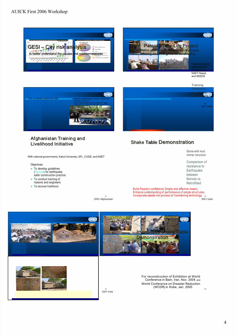
GESIGESI – – City risk analysisCity risk analysis
to better understand the causes and countermeasuresto better understand the causes and countermeasures
Risk comparison among the cities Sources of Earthquake Lethality Potential are
diverse in each city.
What Delhi needs to do to reduce its r isk is
different from what San Salvador needs to do.20
PNYPNY PatankaPatanka NewNew--Life ProjectLife ProjectRehabilitation after Gujarat Earthquake of JanuaryRehabilitation after Gujarat Earthquake of January
2001, focusing on non2001, focusing on non--engineered constructionengineered construction
Training
Education
Awareness
Confidence
Partnership with:
EDM, NCPDP,
NGOs Kobe,
NSET-Nepal,
and SEEDS
2001 India
21
Afghanistan Train ing and Afghanistan Train ing and
Livelihood InitiativeLivelihood Initiative
Objectives
To develop guidelines(Persian) for earthquake
safer construction practice To conduct training of
masons and engineers
To recover livelihood
With national governments, Kabul University, SFL, CODE, and NSET
2003 Afghanistan
22
Shake TableShake Table DemonstrationDemonstration
Build People’s confidence/ Simple and effective means,Enhance understanding of performance of simple struct ures,Incorporate people into process of transferring technology
Stone with mud
mortar structure
Comparison of
resistance to
Earthquake
between
Normal vs.
Retrofitted
2001 India
23
2001 India
24
Improvised Shake TableImprovised Shake Table
DemonstrationDemonstration
For reconstruction of Exhibition at WorldConference in Bam, Iran, Nov. 2004 and
World Conference on Disaster Reduction(WCDR) in Kobe, Jan. 2005

7/23/2019 Japan Land Use Presentation
http://slidepdf.com/reader/full/japan-land-use-presentation 13/15
AUICK First 2006 Workshop
5
25
Sustainability inSustainability in CCommunityommunity --BBasedased
DDisaster isaster MManagementanagement (2002(2002--2005)2005)
Year 1 (2002):
Framework for sustainable CBDM
through 6 case studies in Bangladesh,
Cambodia, India, Indonesia, Nepal,
and the Philippines
Year 2 (2003):
Development of Guidelines forSustainable CBDM and field testing in
Bangladesh, Viet Nam, and the
Philippines
Year 3 (2004):
Application of the Guidelines in Viet
Nam and Mongolia, Partnership building
2001 India
26
UNCRD Activities at WCDRUNCRD Activities at WCDR
((WWorldorld CConferenceonference onon DDisaster isaster RReduction)eduction)
Publication of the outcome of the various CBDM
projects “User’s Guide,” “Tapestry,” and “Digest”
Panel 4 on “reducing the underlying risk factors”
Sessions on “CBDM” (21 Jan. 2005) and “Policies
for Safer Housing/Building” (19 Jan. 2005)
International Symposium on “Safer Communities”
on 21 Jan. 2005 in Kobe.
Shake Table Demonstration on 18 and 21 Jan.
Jan. 2005, Kobe, Hyogo, Japan
27
UNCRD’s Activi ties in 2005 WCDR in Kobe
28
Fields of Disaster Management
29
New Programs of UNCRDNew Programs of UNCRD 20052005
Urbanisation and Community-Based
Disaster Management (2005-2007) in
Nepal, Bangladesh, Indonesia,
Thailand and Sri Lanka.
“ Reducing Vulnerabilit y of School
Children to Earthquake” project
(2005- 2006) in Uzbekistan, India,
Indonesia and Fiji.30
New Programs of UNCRDNew Programs of UNCRD 20062006
Housing Earthquake Safety Initiative
(HESI) as a three-year program
(2006-2008)
“ Anti -seismic Building Code
Dissemination (ABCD)” project (2006)
in Nepal, Indonesia, Japan, and other
seismic countries.
(based on the application)
(Planned)

7/23/2019 Japan Land Use Presentation
http://slidepdf.com/reader/full/japan-land-use-presentation 14/15
AUICK First 2006 Workshop
6
31
Urbanisation and Community-Based
Disaster Management (2005-2007)
32
Reducing Vulnerability of School
Children to Earthquake (2005-2006)
33
School Earthquake SafetySchool Earthquake Safety
Initiative (SESI)Initiative (SESI)
Retrofit
Bal Vikas Secondary School, Nepal
•Strengthen school buildings (retrofitting)
•Technology transfer and training of masons/engineers
•Disaster education and mitigation culture 34
School Earthquake Safety InitiativeSchool Earthquake Safety Initiative
-- Seeing is believingSeeing is believing
-- Doing is believingDoing is believing
-- Training of school childrenTraining of school children
-- Promotion of Mitigation CulturePromotion of Mitigation Culture
Source: ITB, Indonesia 2001
(SESI)(SESI)
35
Housing Earthquake Safety Initiative
(HESI) “ Ant i-seismic Bui ldi ng Code Disseminati on
(ABCD)” project (2006)
36
Field Surveys of Past Disasters

7/23/2019 Japan Land Use Presentation
http://slidepdf.com/reader/full/japan-land-use-presentation 15/15
AUICK First 2006 Workshop
37
Field Survey (North Pakistan Earthquake)
38
Recent Symposiums and Publications
2003 Int’l Workshop on Earthquake Safer World, Kobe
2003 Int’l Workshop on Reconstruction, India
2003 Towards Sustainable Community Recovery, PNY
2003 Sustainability in Grass-Roots Initiatives: CBDM
2003 Guidelines for Earthquake Resistant Design
2003 From Disaster to Community Development, Kobe
2004 Int’l Symposium on Community Legacy, Kobe
2004 Int’l Conf. on Partnership in CBDM in Asia, India
2004 A User’s Guide – CBDM Practices in Asia
2004 UNCRD Tapestry / UNCRD Digest
2005 World Conf. on Disaster Reduction (WCDR), Kobe
2005 UNCRD at UN WCDR 2005, Proceedings
39
Japanese ProverbsJapanese Proverbs
40
http://www.hyogo.uncrd.or.jpE-mail: [email protected]
Tel: 81-78-262-5560 Fax: 81-78-262-5568
UNCRD
Disaster Management Planning
Hyogo Office