Embed Size (px)
Citation preview
1 J.E. Hughes Clarke, OMG/UNBGGE6022 Special topics in Ocean Mapping
GGE6022Special Topics in Ocean Mapping
environmental controls on on survey design
John E. Hughes Clarke

2 J.E. Hughes Clarke, OMG/UNBGGE6022 Special topics in Ocean Mapping
the main objective is to learn how to perform
an in-depth analysis of the oceanographic and sedimentological framework of a geographic region
(an area in which you intend to conduct a hydrographic survey).
The focus of the analysis is to be able to
reasonably predict the performance of acoustic survey instrumentation in the region
and thus influence the design of the most-economic and informative survey.

3 J.E. Hughes Clarke, OMG/UNBGGE6022 Special topics in Ocean Mapping
The performance of acoustic sensors in Hydrographic Survey is influenced by:
Oceanography: Propagation, RefractionSurficial Geology: Reflection and Scattering
And increasingly the main focus of the survey is not nautical charting, rather it is the oceanography and surficial sedimentology for the purposes of:
•Environmental/Pollution monitoring•Offshore Engineering •Fisheries habitat mapping•Rapid Environmental Assessment (REA)•Mine Laying Potential (burial/clutter)

4 J.E. Hughes Clarke, OMG/UNBGGE6022 Special topics in Ocean Mapping
Using your knowledge gained in:
GGE 3353 and GGE 5013 (or equivalent)
Research a case study of theoceanographic and surficial sedimentological
variability in a specific geographic region
For the purpose of:
Conducting an acoustic survey
5 J.E. Hughes Clarke, OMG/UNBGGE6022 Special topics in Ocean Mapping
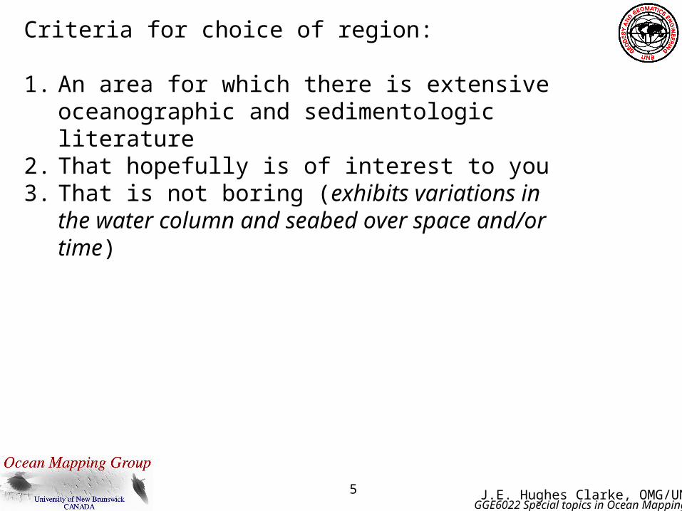
Criteria for choice of region:
1. An area for which there is extensive oceanographic and sedimentologic literature
2. That hopefully is of interest to you3. That is not boring (exhibits variations in the water
column and seabed over space and/or time)
6 J.E. Hughes Clarke, OMG/UNBGGE6022 Special topics in Ocean Mapping
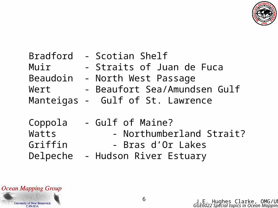
Bradford - Scotian ShelfMuir - Straits of Juan de FucaBeaudoin - North West PassageWert - Beaufort Sea/Amundsen GulfManteigas - Gulf of St. Lawrence
Coppola - Gulf of Maine?Watts - Northumberland Strait?Griffin - Bras d’Or LakesDelpeche - Hudson River Estuary
7 J.E. Hughes Clarke, OMG/UNBGGE6022 Special topics in Ocean Mapping
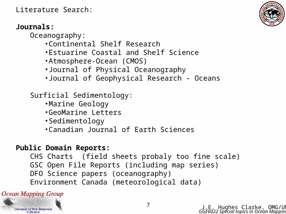
Literature Search:
Journals:Oceanography:
•Continental Shelf Research•Estuarine Coastal and Shelf Science•Atmosphere-Ocean (CMOS)•Journal of Physical Oceanography•Journal of Geophysical Research - Oceans
Surficial Sedimentology:•Marine Geology•GeoMarine Letters•Sedimentology•Canadian Journal of Earth Sciences
Public Domain Reports:CHS Charts (field sheets probaly too fine scale)GSC Open File Reports (including map series)DFO Science papers (oceanography)Environment Canada (meteorological data)

8 J.E. Hughes Clarke, OMG/UNBGGE6022 Special topics in Ocean Mapping
Preliminary Study : - due by mid term
Background Literature Search - At least 20 references should be available (don't choose interesting but insufficiently studied areas!).
Geological Framework, Physical Constraints - describe the principal geological units that make up the lithified bedrock in the area. Define the contributing watersheds in the surrounding terrestrial topography. Potential sources and sinks of terrigenous and/or carbonate sediment (modern deltas, reefs, relict sediments) . Obtain the best bathymetric model of the area outlining the boundary constraints (links to open ocean, headlands, constrictions, sources of freshwater).
Meterological Environment - seasonal rainfall, wind directions, temperature, sunshine, influence of ice formation.
Tidal Regime Analysis - Using the available tidal constituents for stations within the area of interest describe the type and range of the tides. Discuss the propagation (phase and amplitude variability) of the tides throughout the region of interest. Preliminary study must be presented as a document accompanying an oral presentation to the class at the time of the mid-term....
Week of 21st October - Oral Presentation of Preliminary Study Week of 28th October - Delivery of Preliminary Report

9 J.E. Hughes Clarke, OMG/UNBGGE6022 Special topics in Ocean Mapping
Detailed Study - due by end of term
Oceanographic Environment - Description of the temperature and salinity structure of the region, its likely variability daily , tidally (if known), seasonally and geographically. An explanation of the driving forces on the hydrographic regime (open ocean forcing, tidal mixing, wave mixing, solar heating, fresh water influences).
Sedimentological Environment - Modern surficial sediment distribution - what fraction is active and what relict. Recent sealevel history transgressive-regressive. Modern sources and sinks of sediment. Modes of sediment transport. Influence of tidal currents, v. unidirectional v. wave resuspension, ice rafting etc....
Detailed study must be presented as a document accompanying an oral presentation to the class at the time of the final.
Week of 8th December - Oral Presentations to Class of Detailed Study Week of 15th December - Final delivery of Hard Copy Report

10 J.E. Hughes Clarke, OMG/UNBGGE6022 Special topics in Ocean Mapping
Summer time Sea Surface Temperature
? Why does it look like this ?
Surface and subsurface Distribution of
T and S
as a function oftime of year
Surface (and subsurface IF available)
Tidal AND residual currents
From J. Sharples, SOC)

11 J.E. Hughes Clarke, OMG/UNBGGE6022 Special topics in Ocean Mapping
Surficial Geology:
What is the source of the available interpretations?
•Grabs•Echo-trace interpretations•Subbottom profiler records•100% multibeam coverage
What is the density of the available data?
•Reconnaissance•Systematic (5km, 1km, 100m)•100% coverage..
How should we interpret “sedimentary facies” in terms of Bottom roughness and surficial impedance ?
•Is the LaHave Clay a clay (no)•Is the Emerald Silt a silt (rarely)
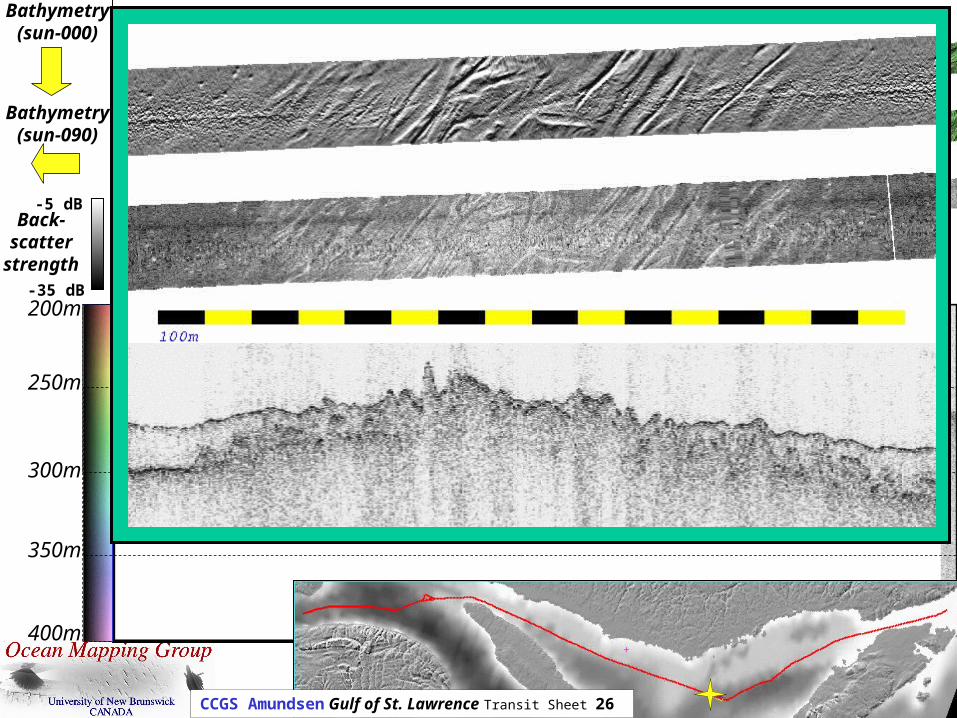
12 J.E. Hughes Clarke, OMG/UNBGGE6022 Special topics in Ocean Mapping
-35 dB
-5 dBBack-scatter
strength
Bathymetry(sun-000)
Bathymetry(sun-090)
5000m200m
250m
300m
350m
400m
CCGS Amundsen Gulf of St. Lawrence Transit Sheet 26

13 J.E. Hughes Clarke, OMG/UNBGGE6022 Special topics in Ocean Mapping
Assessment:
Midterm Report 25%Final Report 75%
week of: Tuesday
8th Sept. -15th -22nd -29th intro6th Oct. no class13th20th Oral presentation of midterm reports27th Written presentation of midterm reports3rd Nov.10th no class17th -24th -1st Dec. -8th Oral presentation of final Reports15th Written presentation of final Reports