Embed Size (px)
Citation preview
Mario F. Palafox Sr. Weather Specialist
Weather Forecasting SectionWeather Division, PAGASA
JMA/WMO WORKSHOP ON EFFECTIVE TROPICAL CYCLONE WARNING IN SOUTHEAST ASIA
Tokyo, Japan11-14 March 2014
The Philippines is prone to Tropical Cycloneoccurrences due to its geographical location. Anaverage of 20 Tropical Cyclones occur each year andabout 8 or 9 of these make landfall. With it comesheavy rains resulting to flooding of large areas,landslides along mountain slopes, strong winds andstorm surges which often results in heavy casualtiesto human life and destructions to crops andproperties. Thus, it is of utmost importance forPAGASA to have an effective Tropical CycloneWarning System to mitigate the adverse effects ofthis weather system for the benefit of the wholenation.
1. Tropical Cyclone Monitoring, Analysis and Forecasting
1.1 Tropical Cyclone Monitoring1.1.1 Tropical Cyclogenesis Monitoring
If a Low Pressure Area (LPA) develops within or near the Philippine Area of Responsibility (PAR), it is closely monitored by PAGASA for signs of intensification. One of the techniques still used is persistence. If the cloud cluster of this LPA persists for more than 1 day and NWP’s are predicting intensification, then the higher the chance it may develop into a Tropical Depression. Also, PAGASA consults other meteorological center for their prognosis of this LPA.
When a Low Pressure Area (LPA) located inside the PAR intensifies into a Tropical Cyclone (TC) or when it enters the PAR already a TC, PAGASA issues a Weather Bulletin (Alert/Warning) and International Warning for Shipping. It is promptly disseminated to the National Disaster Risk Reduction Management Council (NDRRMC) and the Office of Civil Defense (OCD) and other agencies involved in disaster management and to various media such as television, radio, newspaper and social media and is also uploaded into the PAGASA website.
1.1.2 Tropical Depression (TD) Warning
An intensive training on the use of Dvorak technique and other techniques in determining the intensity of the TC and to further develop a criteria for tropical cyclogenesis and monitoring of the development of Tropical Depression in order to issue appropriate warnings.
1.1.3 Challenges, Needs and Improvement Plans
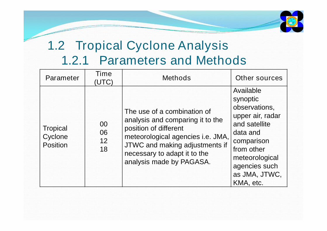
1.2 Tropical Cyclone Analysis1.2.1 Parameters and Methods
Parameter Time (UTC) Methods Other sources
Tropical Cyclone Position
00061218
The use of a combination of analysis and comparing it to the position of different meteorological agencies i.e. JMA, JTWC and making adjustments if necessary to adapt it to the analysis made by PAGASA.
Available synoptic observations, upper air, radar and satellite data and comparison from other meteorological agencies such as JMA, JTWC, KMA, etc.
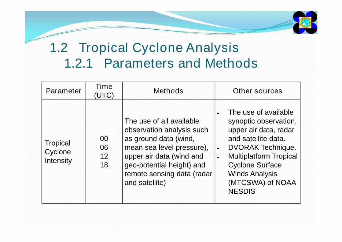
1.2 Tropical Cyclone Analysis1.2.1 Parameters and Methods
Parameter Time (UTC) Methods Other sources
Tropical Cyclone Intensity
00061218
The use of all available observation analysis such as ground data (wind, mean sea level pressure), upper air data (wind and geo-potential height) and remote sensing data (radar and satellite)
The use of available synoptic observation, upper air data, radar and satellite data.
DVORAK Technique. Multiplatform Tropical
Cyclone Surface Winds Analysis (MTCSWA) of NOAA NESDIS
1.2.2 Challenges, Needs and Improvement Plans
Further training of forecasters on TC tracking especially of Tropical Depressions and low intensity Tropical Storms most especially at night and on DVORAK technique.
1.3 Tropical Cyclone Forecasting1.3.1 Parameters and Methods
Parameter Time (UTC)
Lead Time(hours) Other sources
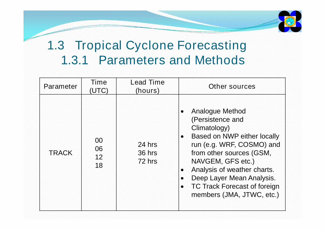
TRACK
00061218
24 hrs36 hrs72 hrs
Analogue Method (Persistence and Climatology)
Based on NWP either locally run (e.g. WRF, COSMO) and from other sources (GSM, NAVGEM, GFS etc.)
Analysis of weather charts. Deep Layer Mean Analysis. TC Track Forecast of foreign
members (JMA, JTWC, etc.)
1.3 Tropical Cyclone Forecasting1.3.1 Parameters and Methods
Parameter Time (UTC) Lead Time(hours) Other sources
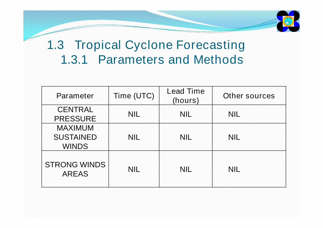
CENTRAL PRESSURE NIL NIL NIL
MAXIMUM SUSTAINED
WINDSNIL NIL NIL
STRONG WINDS AREAS NIL NIL NIL
1.4 Tropical Cyclone Products1.4.1 TC Products
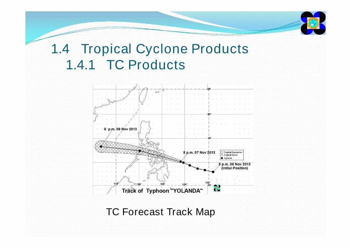
TC Forecast Track Map
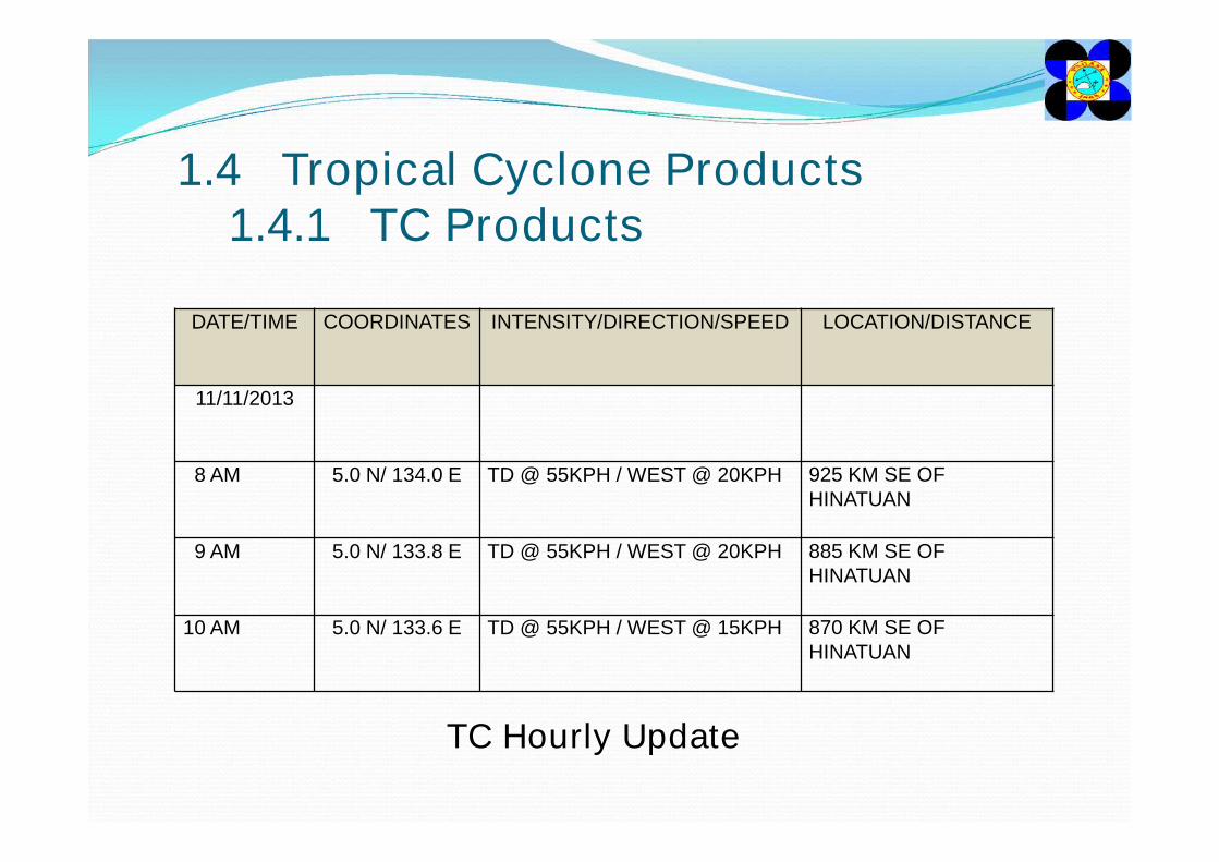
1.4 Tropical Cyclone Products1.4.1 TC Products
TC Hourly Update
DATE/TIME COORDINATES INTENSITY/DIRECTION/SPEED LOCATION/DISTANCE
11/11/2013
8 AM 5.0 N/ 134.0 E TD @ 55KPH / WEST @ 20KPH 925 KM SE OF HINATUAN
9 AM 5.0 N/ 133.8 E TD @ 55KPH / WEST @ 20KPH 885 KM SE OF HINATUAN
10 AM 5.0 N/ 133.6 E TD @ 55KPH / WEST @ 15KPH 870 KM SE OF HINATUAN

1.4 Tropical Cyclone Products1.4.1 TC Products
Hourly Satellite and Radar Imageries
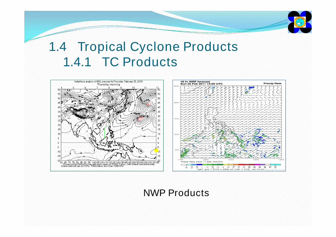
1.4 Tropical Cyclone Products1.4.1 TC Products
NWP Products
1.4.2 Chalenges, Needs and Improvement Plans
• Ensuring that the Products are understood and received on time by the end-users.
• Automatic dissemination of products
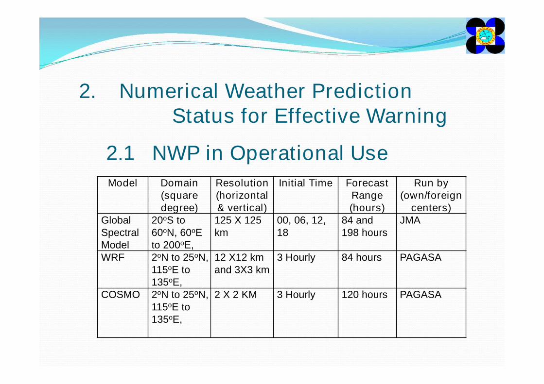
2. Numerical Weather Prediction Status for Effective Warning
Model Domain(squaredegree)
Resolution(horizontal & vertical)
Initial Time Forecast Range (hours)
Run by(own/foreign
centers)Global Spectral Model
20oS to 60oN, 60oE to 200oE,
125 X 125 km
00, 06, 12, 18
84 and 198 hours
JMA
WRF 2oN to 25oN, 115oE to 135oE,
12 X12 km and 3X3 km
3 Hourly 84 hours PAGASA
COSMO 2oN to 25oN, 115oE to 135oE,
2 X 2 KM 3 Hourly 120 hours PAGASA
2.1 NWP in Operational Use
2.3 Challenges, Needs and Improvement Plans
• There is a need for a comprehensive training on the utilization of numerical model output and to have an ensemble analysis.
• The plan to provide Model Output Statistics (MOS) for each model to provide higher confidence on the output of each model.
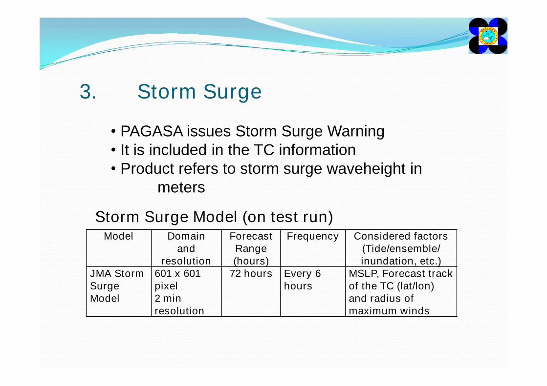
3. Storm Surge
• PAGASA issues Storm Surge Warning• It is included in the TC information• Product refers to storm surge waveheight in
meters
Model Domainand
resolution
Forecast Range (hours)
Frequency Considered factors(Tide/ensemble/ inundation, etc.)
JMA Storm Surge Model
601 x 601 pixel2 min resolution
72 hours Every 6 hours
MSLP, Forecast track of the TC (lat/lon) and radius of maximum winds
Storm Surge Model (on test run)
4. Effective Warnings4.1 Emergency Response for TC
Disasters4.1.1 Legal Framework for TC
Disaster ManagementIn the Philippines, the disaster management is guided by Republic Act 101201 known as AN ACT STRENGTHENING THE PHILIPPINE DISASTER RISK REDUCTION AND MANAGEMENT SYSTEM, PROVIDING FOR THE NATIONAL DISASTER RISK REDUCTION AND MANAGEMENT FRAMEWORK AND INSTITUTIONALIZING THE NATIONAL DISASTER RISK REDUCTION AND MANAGEMENT PLAN. PAGASA as a member of the council is mandated to provide warnings and related information for community preparedness.
4.1.2 Emergency Response Mechanism
The National Disaster Risk Reduction and Management Council (NDRRMC) convenes to make preparatory steps to mitigate the adverse impact of a Tropical Cyclone and mobilizing member agencies during disaster for response such as evacuation and relief efforts. After the disaster, the council is still in charge with rehabilitation. The council is from the National level down to the smallest unit of the government which is the Barangay.
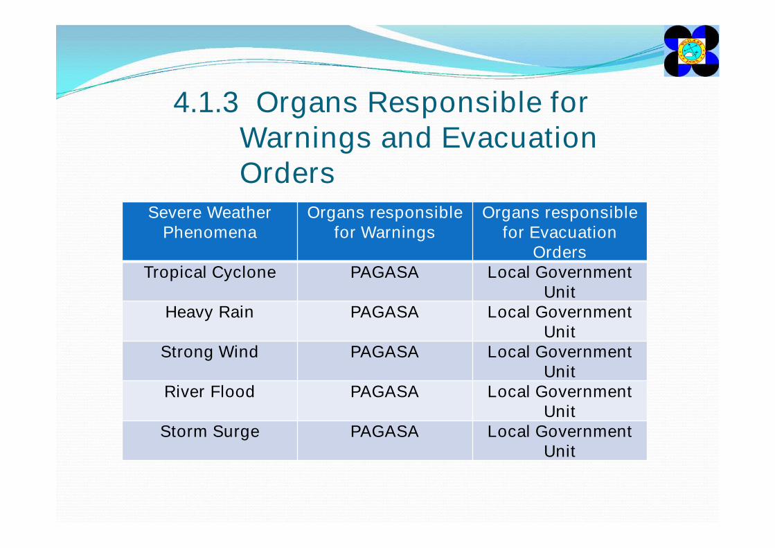
4.1.3 Organs Responsible for Warnings and Evacuation Orders
Severe Weather Phenomena
Organs responsible for Warnings
Organs responsible for Evacuation
OrdersTropical Cyclone PAGASA Local Government
UnitHeavy Rain PAGASA Local Government
UnitStrong Wind PAGASA Local Government
UnitRiver Flood PAGASA Local Government
UnitStorm Surge PAGASA Local Government
Unit
4.2 Warnings/Advisories for Severe Weather Phenomena
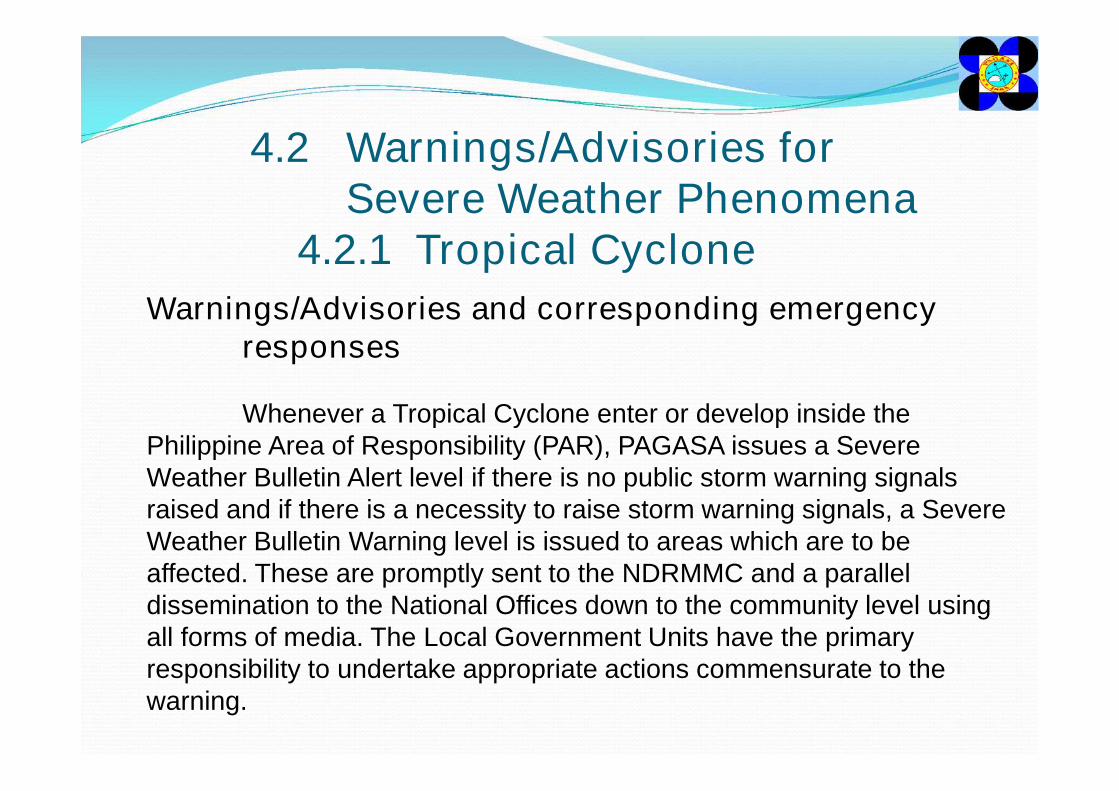
4.2.1 Tropical CycloneWarnings/Advisories and corresponding emergency
responses
Whenever a Tropical Cyclone enter or develop inside the Philippine Area of Responsibility (PAR), PAGASA issues a Severe Weather Bulletin Alert level if there is no public storm warning signals raised and if there is a necessity to raise storm warning signals, a Severe Weather Bulletin Warning level is issued to areas which are to be affected. These are promptly sent to the NDRMMC and a parallel dissemination to the National Offices down to the community level using all forms of media. The Local Government Units have the primary responsibility to undertake appropriate actions commensurate to the warning.
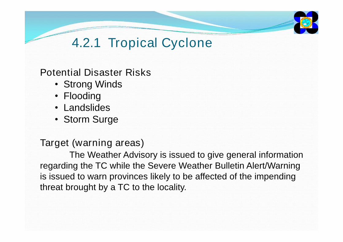
4.2.1 Tropical Cyclone
Potential Disaster Risks• Strong Winds• Flooding• Landslides• Storm Surge
Target (warning areas)The Weather Advisory is issued to give general information
regarding the TC while the Severe Weather Bulletin Alert/Warning is issued to warn provinces likely to be affected of the impending threat brought by a TC to the locality.
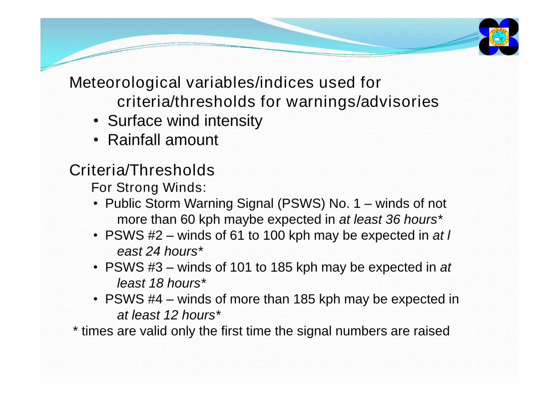
Meteorological variables/indices used for criteria/thresholds for warnings/advisories
• Surface wind intensity• Rainfall amount
Criteria/ThresholdsFor Strong Winds:• Public Storm Warning Signal (PSWS) No. 1 – winds of not
more than 60 kph maybe expected in at least 36 hours*• PSWS #2 – winds of 61 to 100 kph may be expected in at l
east 24 hours*• PSWS #3 – winds of 101 to 185 kph may be expected in at
least 18 hours*• PSWS #4 – winds of more than 185 kph may be expected in
at least 12 hours** times are valid only the first time the signal numbers are raised
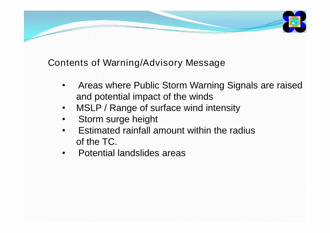
Contents of Warning/Advisory Message
• Areas where Public Storm Warning Signals are raised and potential impact of the winds
• MSLP / Range of surface wind intensity• Storm surge height• Estimated rainfall amount within the radius
of the TC.• Potential landslides areas
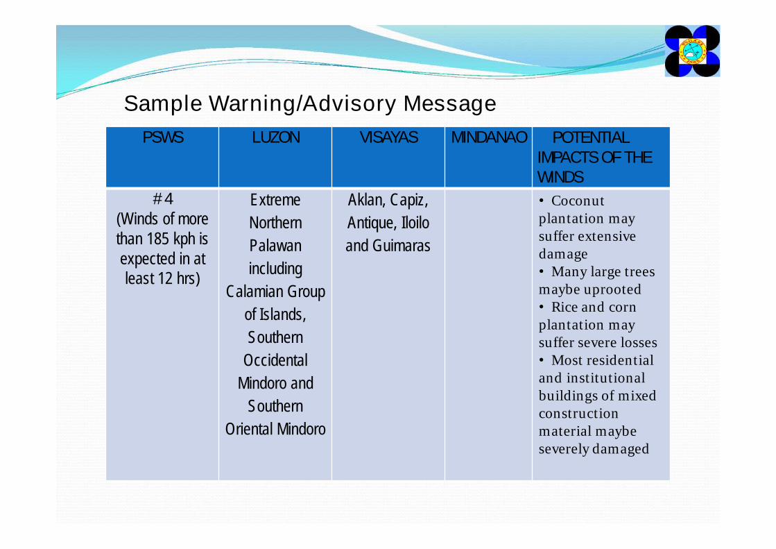
PSWS LUZON VISAYAS MINDANAO POTENTIAL IMPACTS OF THE WINDS
# 4(Winds of more than 185 kph is expected in at least 12 hrs)
Extreme Northern Palawan including
Calamian Group of Islands, Southern
Occidental Mindoro and
Southern Oriental Mindoro
Aklan, Capiz, Antique, Iloilo and Guimaras
• Coconut plantation may suffer extensive damage• Many large trees maybe uprooted• Rice and corn plantation may suffer severe losses• Most residential and institutional buildings of mixed construction material maybe severely damaged
Sample Warning/Advisory Message
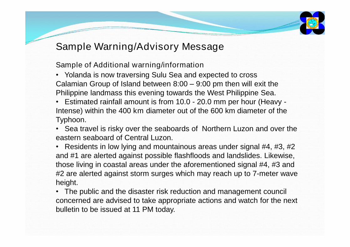
Sample Warning/Advisory Message
• Yolanda is now traversing Sulu Sea and expected to cross Calamian Group of Island between 8:00 – 9:00 pm then will exit the Philippine landmass this evening towards the West Philippine Sea. • Estimated rainfall amount is from 10.0 - 20.0 mm per hour (Heavy -Intense) within the 400 km diameter out of the 600 km diameter of the Typhoon.• Sea travel is risky over the seaboards of Northern Luzon and over the eastern seaboard of Central Luzon.• Residents in low lying and mountainous areas under signal #4, #3, #2 and #1 are alerted against possible flashfloods and landslides. Likewise, those living in coastal areas under the aforementioned signal #4, #3 and #2 are alerted against storm surges which may reach up to 7-meter wave height.• The public and the disaster risk reduction and management council concerned are advised to take appropriate actions and watch for the next bulletin to be issued at 11 PM today.
Sample of Additional warning/information
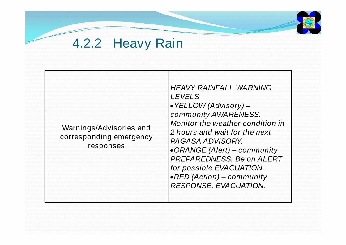
4.2.2 Heavy Rain
Warnings/Advisories and corresponding emergency
responses
HEAVY RAINFALL WARNING LEVELSYELLOW (Advisory) –community AWARENESS. Monitor the weather condition in 2 hours and wait for the next PAGASA ADVISORY.ORANGE (Alert) – community PREPAREDNESS. Be on ALERT for possible EVACUATION.RED (Action) – community RESPONSE. EVACUATION.
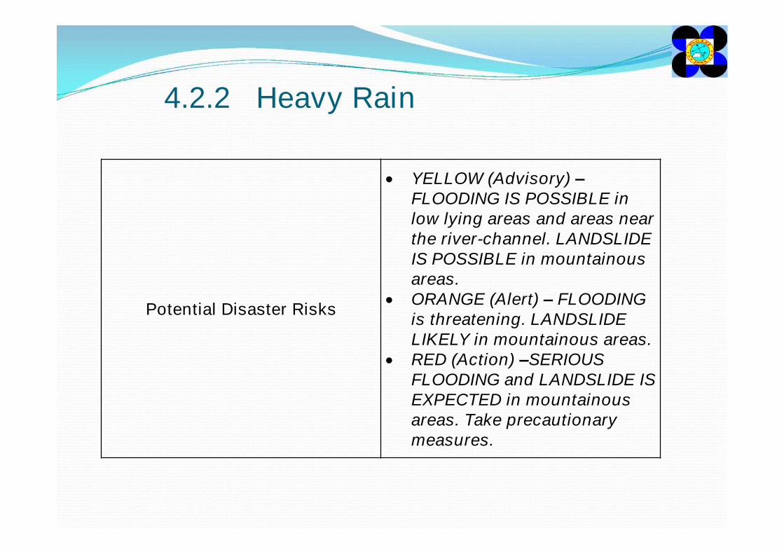
4.2.2 Heavy Rain
Potential Disaster Risks
YELLOW (Advisory) –FLOODING IS POSSIBLE in low lying areas and areas near the river-channel. LANDSLIDE IS POSSIBLE in mountainous areas.
ORANGE (Alert) – FLOODING is threatening. LANDSLIDE LIKELY in mountainous areas.
RED (Action) –SERIOUS FLOODING and LANDSLIDE IS EXPECTED in mountainous areas. Take precautionary measures.
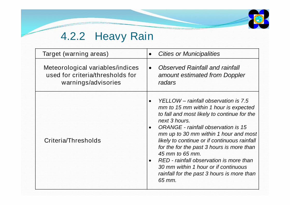
4.2.2 Heavy RainTarget (warning areas) Cities or Municipalities
Meteorological variables/indices used for criteria/thresholds for
warnings/advisories
Observed Rainfall and rainfall amount estimated from Doppler radars
Criteria/Thresholds
YELLOW – rainfall observation is 7.5 mm to 15 mm within 1 hour is expected to fall and most likely to continue for the next 3 hours.
ORANGE - rainfall observation is 15 mm up to 30 mm within 1 hour and most likely to continue or if continuous rainfall for the for the past 3 hours is more than 45 mm to 65 mm.
RED - rainfall observation is more than 30 mm within 1 hour or if continuous rainfall for the past 3 hours is more than 65 mm.
4.2.2 Heavy Rain
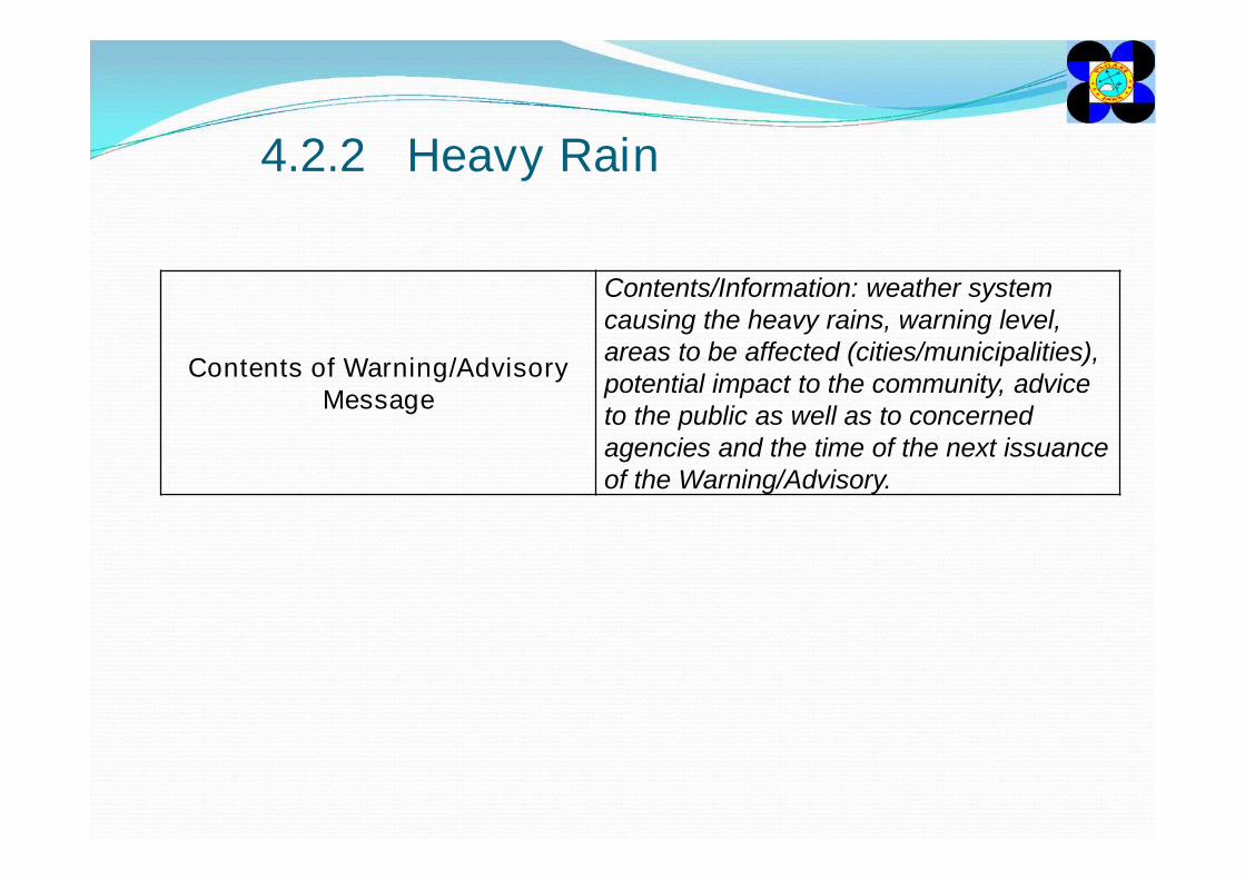
Contents of Warning/Advisory Message
Contents/Information: weather system causing the heavy rains, warning level, areas to be affected (cities/municipalities), potential impact to the community, advice to the public as well as to concerned agencies and the time of the next issuance of the Warning/Advisory.
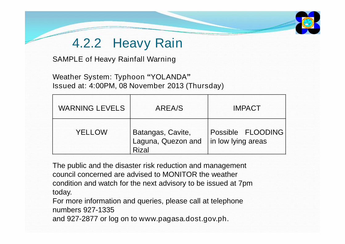
4.2.2 Heavy RainSAMPLE of Heavy Rainfall Warning
Weather System: Typhoon “YOLANDA”Issued at: 4:00PM, 08 November 2013 (Thursday)
The public and the disaster risk reduction and management council concerned are advised to MONITOR the weather condition and watch for the next advisory to be issued at 7pm today. For more information and queries, please call at telephone numbers 927-1335and 927-2877 or log on to www.pagasa.dost.gov.ph.
WARNING LEVELS AREA/S IMPACT
YELLOW Batangas, Cavite, Laguna, Quezon and Rizal
Possible FLOODINGin low lying areas
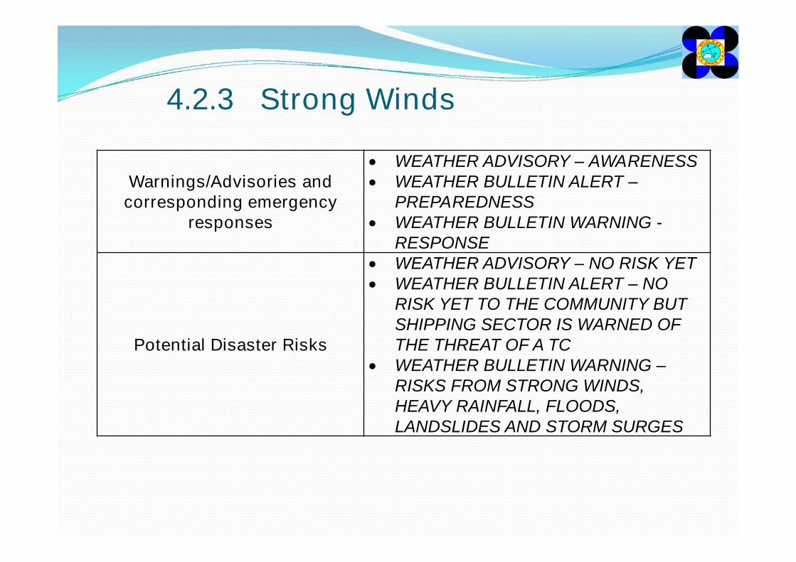
4.2.3 Strong Winds
Warnings/Advisories and corresponding emergency
responses
WEATHER ADVISORY – AWARENESS WEATHER BULLETIN ALERT –
PREPAREDNESS WEATHER BULLETIN WARNING -
RESPONSE
Potential Disaster Risks
WEATHER ADVISORY – NO RISK YET WEATHER BULLETIN ALERT – NO
RISK YET TO THE COMMUNITY BUT SHIPPING SECTOR IS WARNED OF THE THREAT OF A TC
WEATHER BULLETIN WARNING –RISKS FROM STRONG WINDS, HEAVY RAINFALL, FLOODS, LANDSLIDES AND STORM SURGES
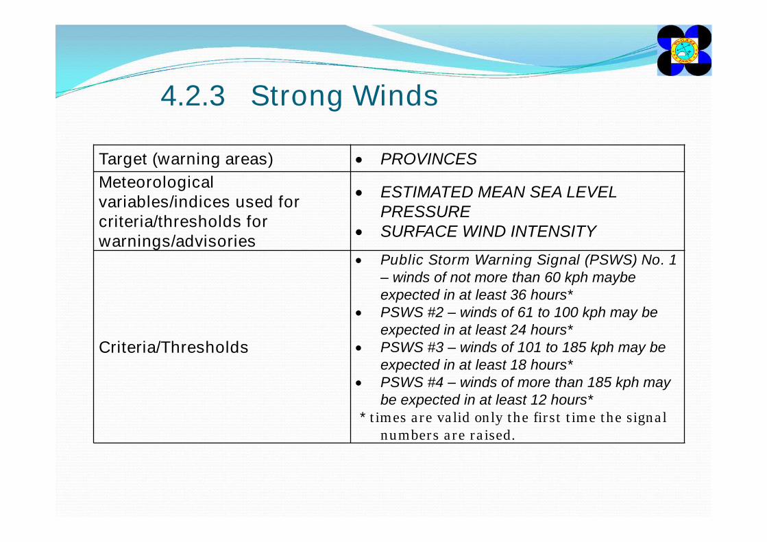
4.2.3 Strong Winds
Target (warning areas) PROVINCESMeteorological variables/indices used for criteria/thresholds for warnings/advisories
ESTIMATED MEAN SEA LEVEL PRESSURE
SURFACE WIND INTENSITY
Criteria/Thresholds
Public Storm Warning Signal (PSWS) No. 1– winds of not more than 60 kph maybe expected in at least 36 hours*
PSWS #2 – winds of 61 to 100 kph may be expected in at least 24 hours*
PSWS #3 – winds of 101 to 185 kph may be expected in at least 18 hours*
PSWS #4 – winds of more than 185 kph may be expected in at least 12 hours*
* times are valid only the first time the signal numbers are raised.
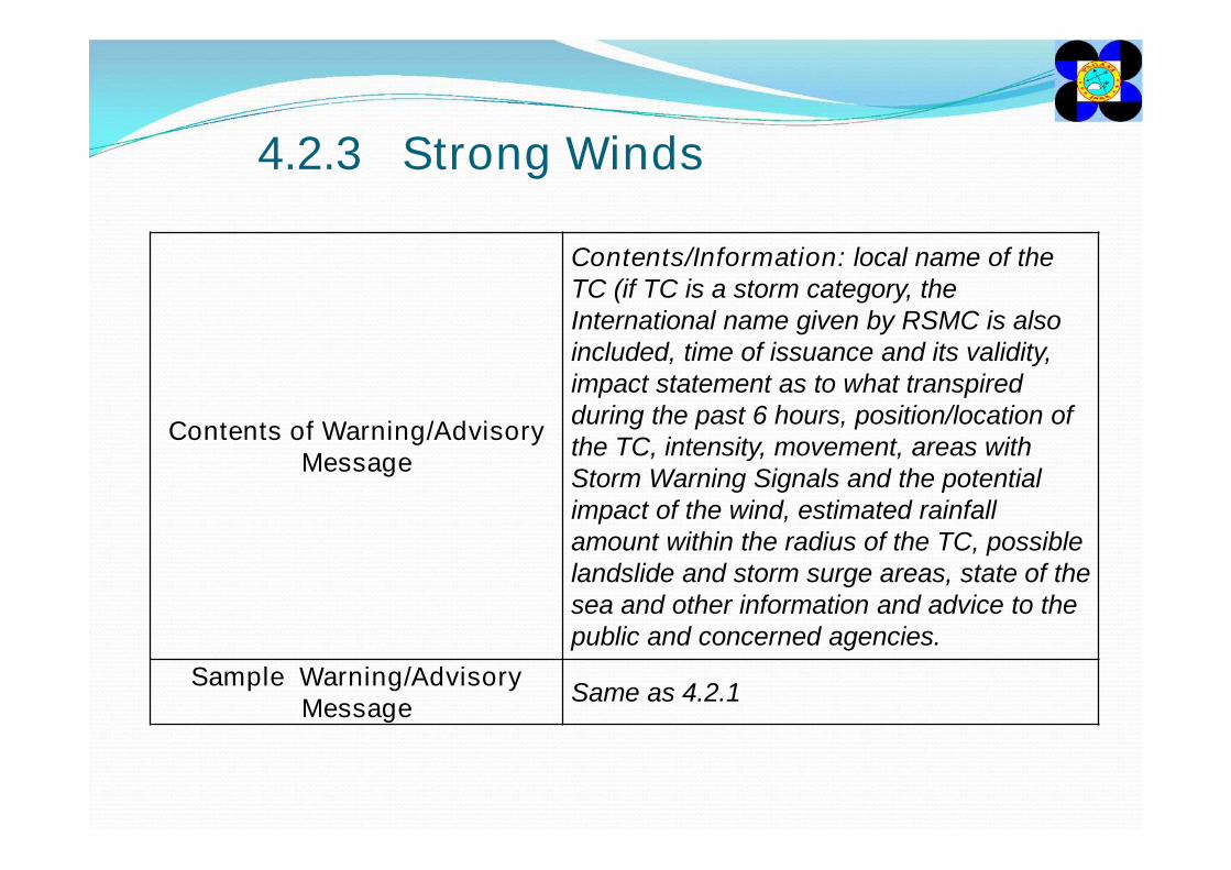
4.2.3 Strong Winds
Contents of Warning/Advisory Message
Contents/Information: local name of the TC (if TC is a storm category, the International name given by RSMC is also included, time of issuance and its validity, impact statement as to what transpired during the past 6 hours, position/location of the TC, intensity, movement, areas with Storm Warning Signals and the potential impact of the wind, estimated rainfall amount within the radius of the TC, possible landslide and storm surge areas, state of the sea and other information and advice to the public and concerned agencies.
Sample Warning/Advisory Message Same as 4.2.1
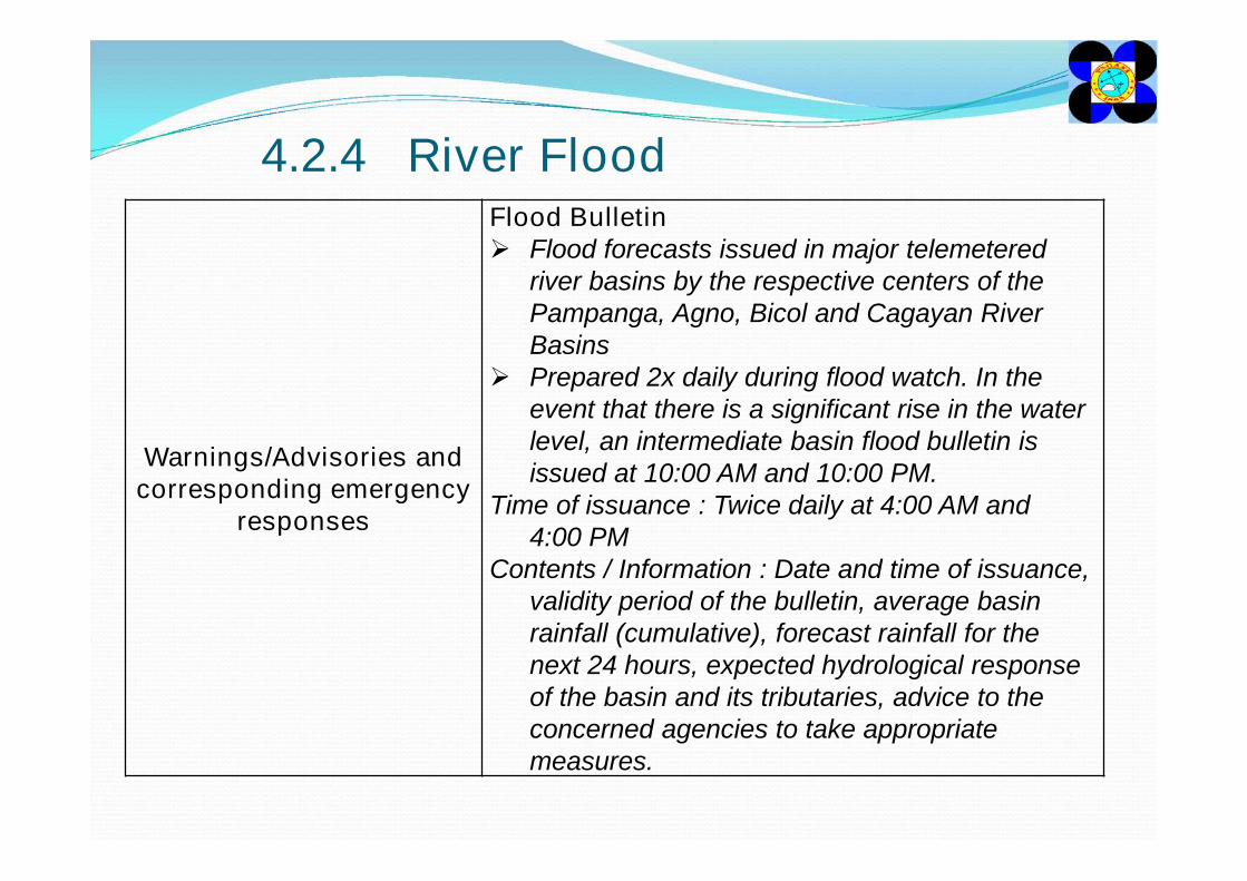
4.2.4 River Flood
Warnings/Advisories and corresponding emergency
responses
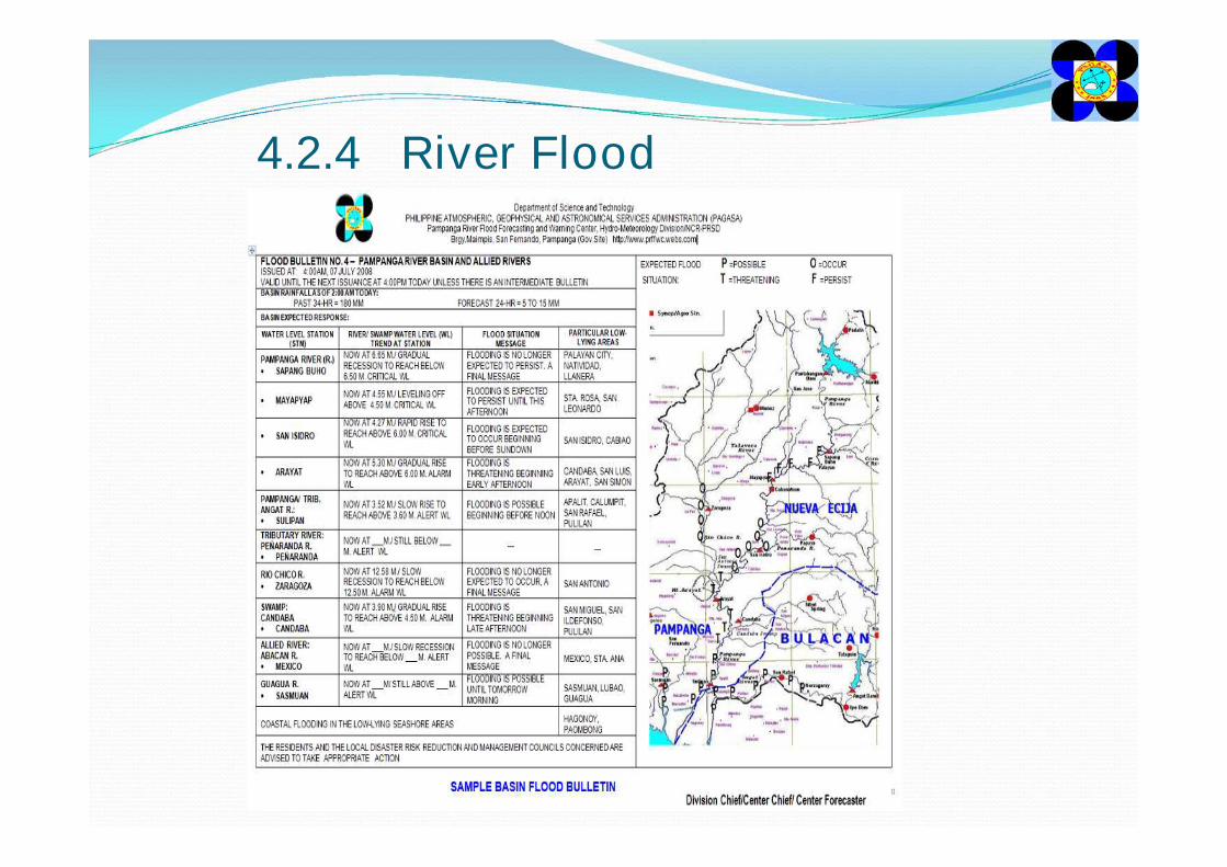
Flood Bulletin Flood forecasts issued in major telemetered
river basins by the respective centers of the Pampanga, Agno, Bicol and Cagayan River Basins
Prepared 2x daily during flood watch. In the event that there is a significant rise in the water level, an intermediate basin flood bulletin is issued at 10:00 AM and 10:00 PM.
Time of issuance : Twice daily at 4:00 AM and 4:00 PM
Contents / Information : Date and time of issuance, validity period of the bulletin, average basin rainfall (cumulative), forecast rainfall for the next 24 hours, expected hydrological response of the basin and its tributaries, advice to the concerned agencies to take appropriate measures.
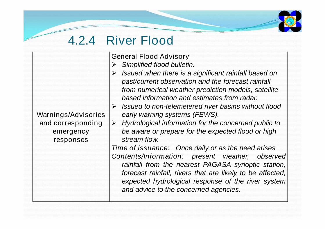
4.2.4 River Flood
Warnings/Advisories and corresponding
emergency responses
General Flood Advisory Simplified flood bulletin. Issued when there is a significant rainfall based on
past/current observation and the forecast rainfall from numerical weather prediction models, satellite based information and estimates from radar.
Issued to non-telemetered river basins without flood early warning systems (FEWS).
Hydrological information for the concerned public to be aware or prepare for the expected flood or high stream flow.
Time of issuance: Once daily or as the need arisesContents/Information: present weather, observed
rainfall from the nearest PAGASA synoptic station,forecast rainfall, rivers that are likely to be affected,expected hydrological response of the river systemand advice to the concerned agencies.
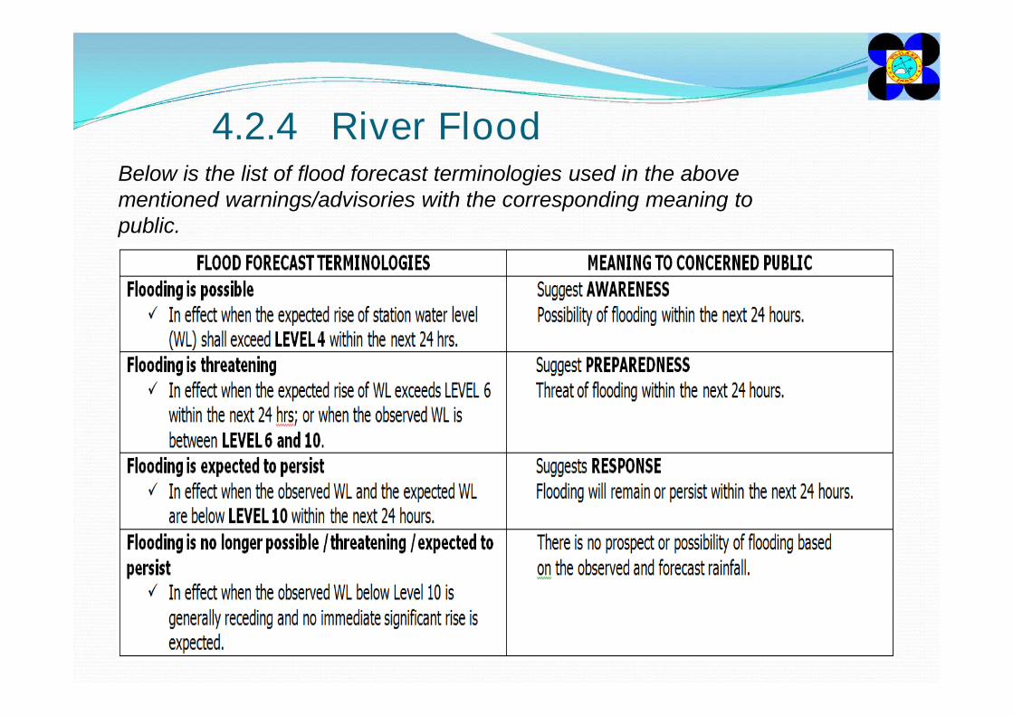
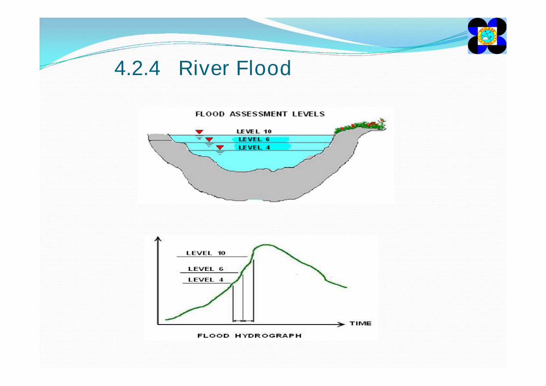
4.2.4 River FloodBelow is the list of flood forecast terminologies used in the above mentioned warnings/advisories with the corresponding meaning to public.
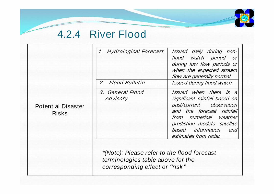
4.2.4 River Flood
Potential Disaster Risks
1. Hydrological Forecast Issued daily during non-flood watch period orduring low flow periods orwhen the expected streamflow are generally normal.
2. Flood Bulletin Issued during flood watch.
3. General Flood Advisory
Issued when there is asignificant rainfall based onpast/current observationand the forecast rainfallfrom numerical weatherprediction models, satellitebased information andestimates from radar.
*(Note): Please refer to the flood forecast terminologies table above for the corresponding effect or “risk”
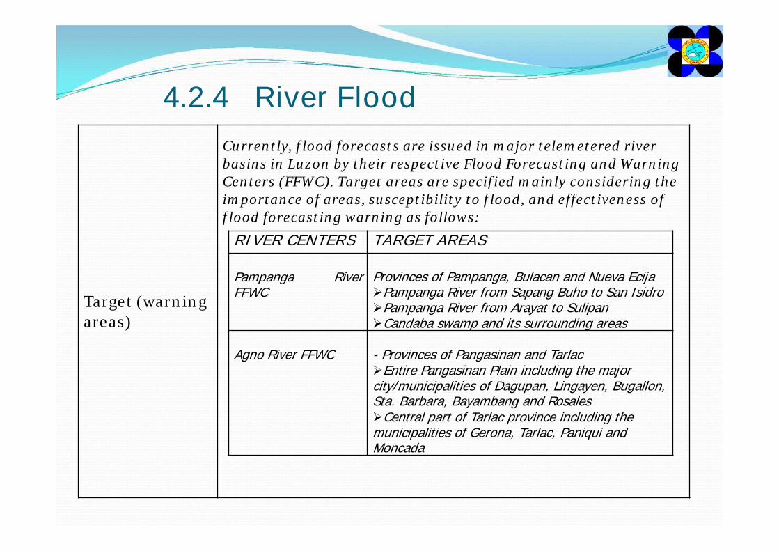
4.2.4 River Flood
Target (warning areas)
Currently, flood forecasts are issued in major telemetered river basins in Luzon by their respective Flood Forecasting and Warning Centers (FFWC). Target areas are specified mainly considering the importance of areas, susceptibility to flood, and effectiveness of flood forecasting warning as follows:
RIVER CENTERS TARGET AREAS
Pampanga RiverFFWC
Provinces of Pampanga, Bulacan and Nueva EcijaPampanga River from Sapang Buho to San IsidroPampanga River from Arayat to SulipanCandaba swamp and its surrounding areas
Agno River FFWC - Provinces of Pangasinan and TarlacEntire Pangasinan Plain including the major city/municipalities of Dagupan, Lingayen, Bugallon, Sta. Barbara, Bayambang and RosalesCentral part of Tarlac province including the municipalities of Gerona, Tarlac, Paniqui and Moncada
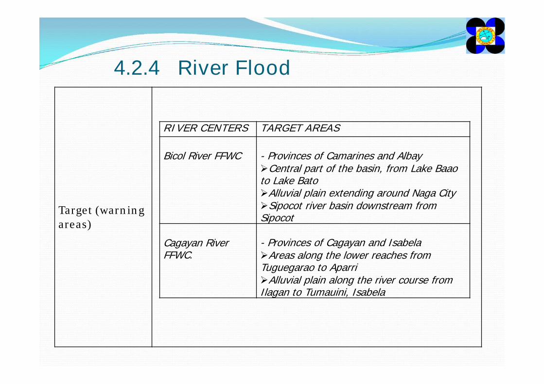
4.2.4 River Flood
Target (warning areas)
RIVER CENTERS TARGET AREAS
Bicol River FFWC - Provinces of Camarines and AlbayCentral part of the basin, from Lake Baao to Lake BatoAlluvial plain extending around Naga CitySipocot river basin downstream from Sipocot
Cagayan River FFWC.
- Provinces of Cagayan and IsabelaAreas along the lower reaches from Tuguegarao to AparriAlluvial plain along the river course from Ilagan to Tumauini, Isabela
4.2.4 River Flood
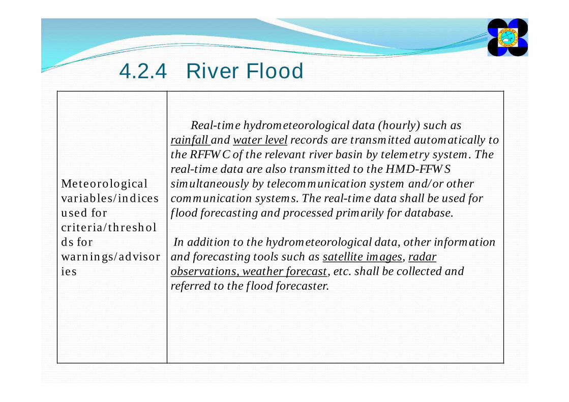
Meteorological variables/indices used for criteria/thresholds for warnings/advisories
Real-time hydrometeorological data (hourly) such as rainfall and water level records are transmitted automatically to the RFFWC of the relevant river basin by telemetry system. The real-time data are also transmitted to the HMD-FFWS simultaneously by telecommunication system and/or other communication systems. The real-time data shall be used for flood forecasting and processed primarily for database.
In addition to the hydrometeorological data, other information and forecasting tools such as satellite images, radar observations, weather forecast, etc. shall be collected and referred to the flood forecaster.
4.2.4 River Flood
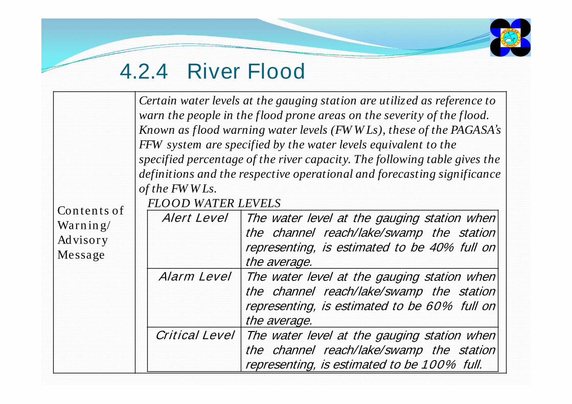
Contents of Warning/Advisory Message
Certain water levels at the gauging station are utilized as reference to warn the people in the flood prone areas on the severity of the flood. Known as flood warning water levels (FWWLs), these of the PAGASA’s FFW system are specified by the water levels equivalent to the specified percentage of the river capacity. The following table gives the definitions and the respective operational and forecasting significance of the FWWLs.
FLOOD WATER LEVELSAlert Level The water level at the gauging station when
the channel reach/lake/swamp the stationrepresenting, is estimated to be 40% full onthe average.
Alarm Level The water level at the gauging station whenthe channel reach/lake/swamp the stationrepresenting, is estimated to be 60% full onthe average.
Critical Level The water level at the gauging station whenthe channel reach/lake/swamp the stationrepresenting, is estimated to be 100% full.
4.2.4 River Flood
4.2.4 River Flood
Sample Warning/Advisory Message
People living near the mountain slopes of the above mentioned places are advised to be alert for possible occurrence of flash floods and landslides. Likewise, people living near or along the river course and those in the flood-prone/low-lying areas near the above mentioned river systems are advised to be alert for possible flooding. The local risk reduction and management councils are advised to take appropriate actions.
4.2.4 River Flood
4.2.5 Storm SurgeWarnings/Advisories and
corresponding emergency responses
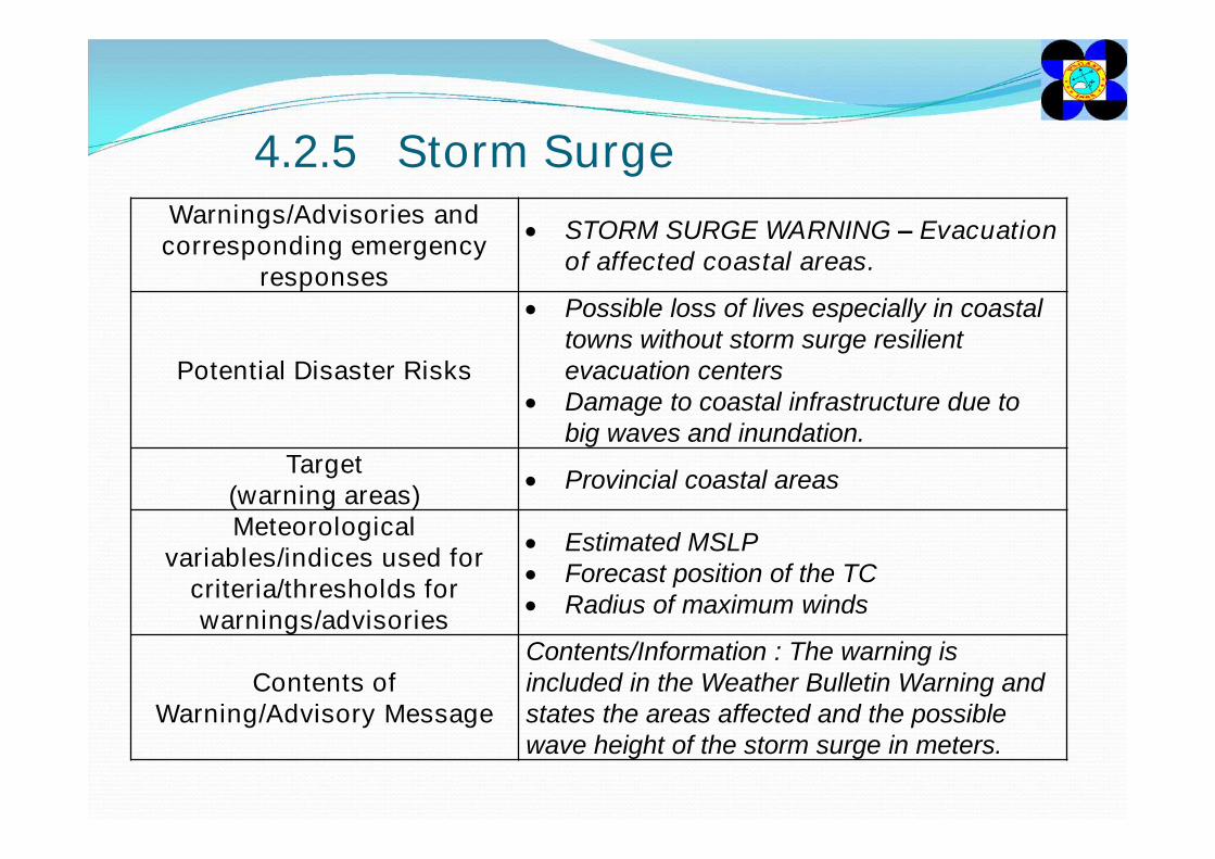
STORM SURGE WARNING – Evacuation of affected coastal areas.
Potential Disaster Risks
Possible loss of lives especially in coastal towns without storm surge resilient evacuation centers
Damage to coastal infrastructure due to big waves and inundation.
Target(warning areas) Provincial coastal areas
Meteorological variables/indices used for
criteria/thresholds for warnings/advisories
Estimated MSLP Forecast position of the TC Radius of maximum winds
Contents of Warning/Advisory Message
Contents/Information : The warning is included in the Weather Bulletin Warning and states the areas affected and the possible wave height of the storm surge in meters.
4.2.5 Storm Surge
Sample Warning/Advisory Message
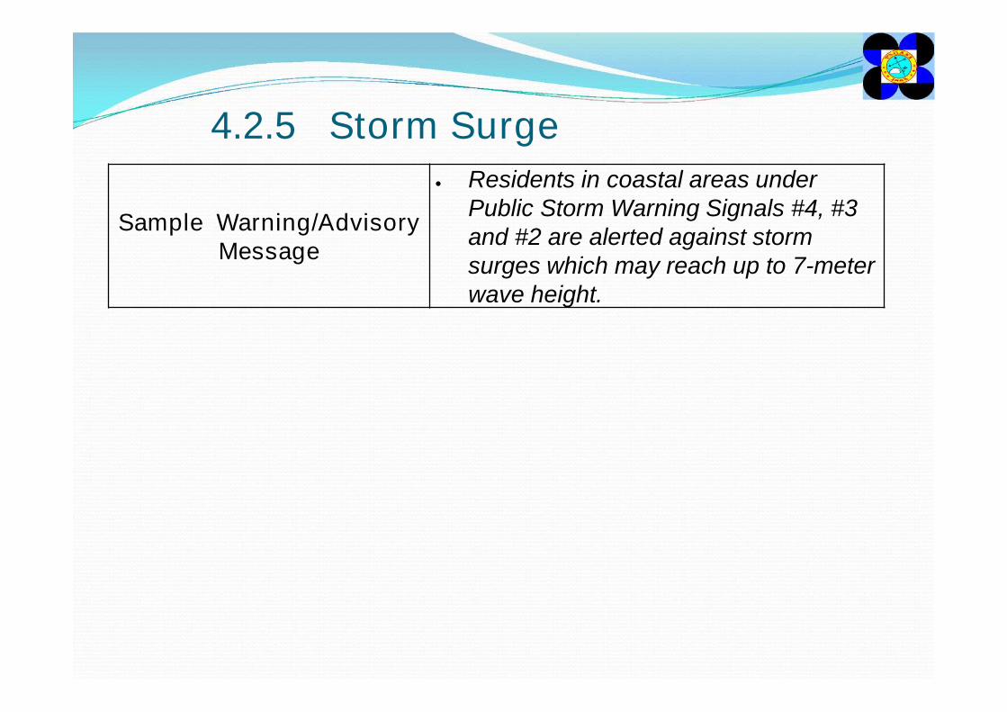
Residents in coastal areas under Public Storm Warning Signals #4, #3 and #2 are alerted against storm surges which may reach up to 7-meter wave height.
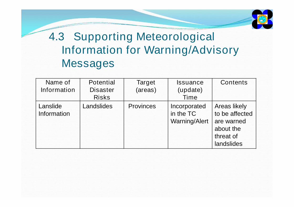
4.3 Supporting Meteorological Information for Warning/Advisory Messages
Name of Information
Potential Disaster
Risks
Target (areas)
Issuance (update)
Time
Contents
Lanslide Information
Landslides Provinces Incorporated in the TC Warning/Alert
Areas likely to be affected are warned about the threat of landslides
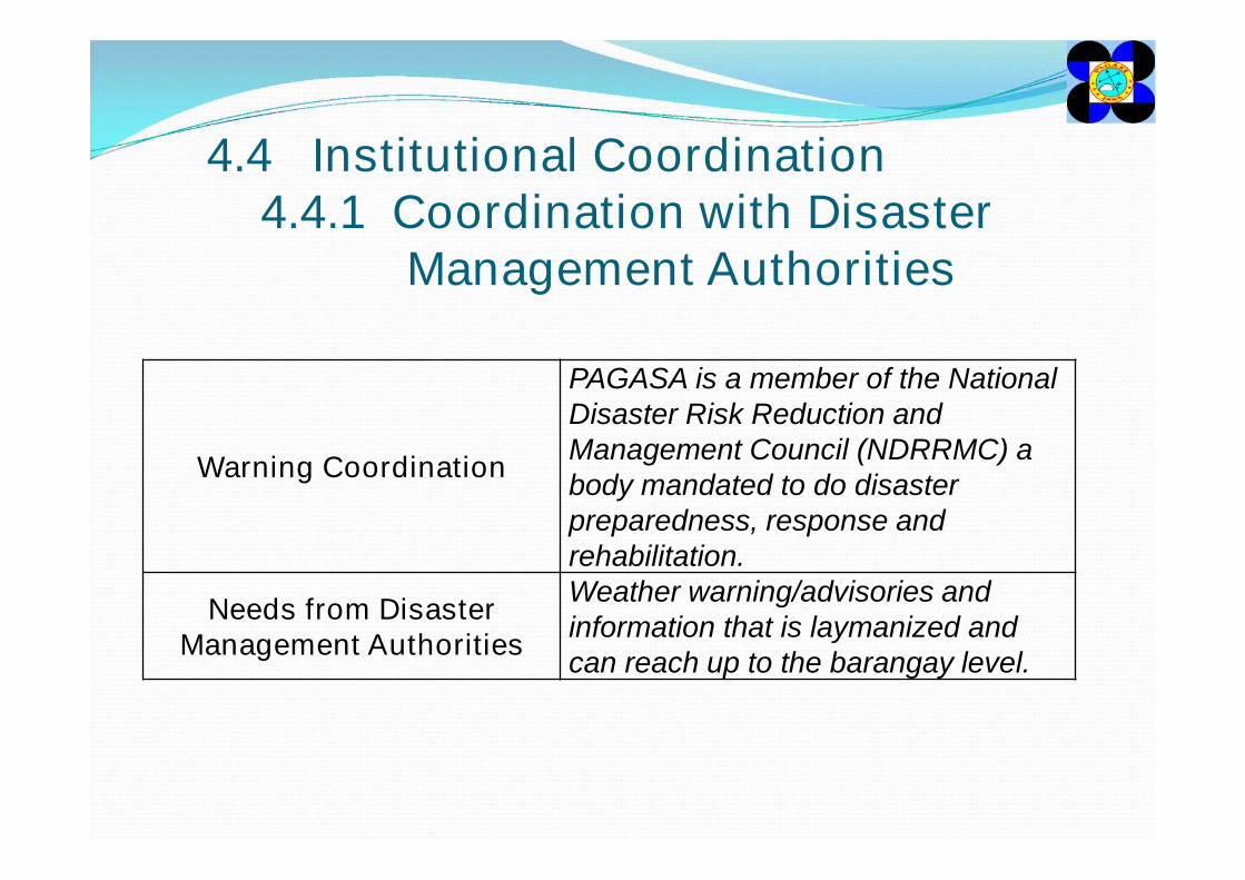
4.4 Institutional Coordination4.4.1 Coordination with Disaster
Management Authorities
Warning Coordination
PAGASA is a member of the National Disaster Risk Reduction and Management Council (NDRRMC) a body mandated to do disaster preparedness, response and rehabilitation.
Needs from Disaster Management Authorities
Weather warning/advisories and information that is laymanized and can reach up to the barangay level.
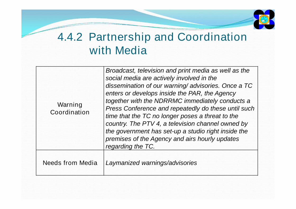
4.4.2 Partnership and Coordination with Media
Warning Coordination
Broadcast, television and print media as well as the social media are actively involved in the dissemination of our warning/ advisories. Once a TC enters or develops inside the PAR, the Agency together with the NDRRMC immediately conducts a Press Conference and repeatedly do these until such time that the TC no longer poses a threat to the country. The PTV 4, a television channel owned by the government has set-up a studio right inside the premises of the Agency and airs hourly updates regarding the TC.
Needs from Media Laymanized warnings/advisories
4.5 Challenges (and Future Plan)
A Tropical Cyclone Workstation and computing platform and better NWP products are much to be desired. Laymanized warnings/advisories that the general public as well as the Disaster Managers can easily understand and can receive on time so that they can carry out appropriate actions to mitigate the adverse effects brought about by a TC.

‘tracking the sky . . . helping the country!!!