Embed Size (px)
Citation preview

Louisiana Department of Natural Resources
Office of Coastal Management (OCM)
Joint Permit Application
For Work Within the Louisiana Coastal Zone U.S. Army Corps Of Engineers
(COE)New Orleans District
Print Application
Permit Number: P20131098 Date Received: 03/19/2018
Step 1 of 15 - Applicant Information
Applicant/CompanyName:
COASTAL PROTECTION & RESTORATION AUTHORITY OF LOUISIANA (CPRA)
Applicant Type:
GOVERNMENT AGENCY
Mailing Address: 150 Terrace AvenueBaton Rouge, LA 70802
Contact Information: Megan Terrell
Daytime: 225 342 6952 Fax: Contact Email:
Step 2 of 15 - Agent Information
CompanyName: Coastal Protection & Restoration Authority (CPRA)
Mailing Address: 150 Terrace AvenueBaton Rouge, LA 70802
Contact Information: Elizabeth Davoli
Daytime: 225 342 4616 Fax: 225 342 4591 Contact Email: [email protected]
Step 3 of 15 - Permit Type
Coastal Use Permit (CUP) Solicitation of Views (SOV) Request for Determination (RFD)
Step 4 of 15 - Pre-Application Activity

a. Have you participated in a Pre-Application or Geological Review Meeting for the proposed project?
No Yes Date meeting was held:05/19/2016
Attendees:Elizabeth Davoli (CPRA)
(Individual or Company Rep)
Stephanie Zumo
(OCM Representative)
Brad LaBorde
(COE Representative)
b. Have you obtained an official wetland determination from the COE for the project site?
No Yes JD Number: MVN-2012-02806-SY
c. Is this application a mitigation plan for another CUP?
No Yes OCM Permit Number:
Step 5 of 15 - Project Information
a. Describe the project:
The Mid-Barataria Sediment Diversion is a large-scale, complex civil works and ecosystem restoration project. When operated, up to 75.000 cubic feet per second (cfs) of sediment-laden water would be diverted from the Mississippi River to the mid-Barataria Basin to reconnect and re-establish the natural or deltaic sediment deposition process between the the Mississippi River and the Barataria Basin to deliver sediment, freshwater, and nutrients to reduce land loss and sustain wetlands.
b. Is this application a change to an existing permit?
No Yes OCM Permit Number:
c. Have you previously applied for a permit or emergency authorization for all or any part of the proposed project?
No Yes
Agency Name Permit Number Decision Status Decision Date
OCM Stephanie Zumo P20131098 Pending
COE Brad LaBorde MVN-2012-02806-EOO Pending
Other
Step 6 of 15 - Project Location

a. Physical Location
Street: Louisiana State Highway 23 (LA 23)
City: Ironton (vicinity) Parish: PLAQUEMINES Zip: 70083
Water Body: Mississippi River (Mile 60.7) / Barataria Basin
b. Latitude and Longitude
Latitude: 29 39 42.5 Longitude: -89 57 48.6
c. Section, Township, and Range
Section #: 5 16 47 48 49 Township #: 16S Range #: 25E
Section #: 3 2 1 41 19 Township #: 17S Range #: 24E
d. Lot, Tract, Parcel, or Subdivision Name
Lot #: Parcel #:
Tract #: Subdivision Name:
e. Site Direction:
START- From I-10 in New Orleans, take US-90Bus W across Mississippi River. Continue on US-90Bus W / Westbank Expy for 4 miles. Take exit #7 for LA 23 / Lafayette St. Continue south on LA 23 for 21 miles to the project area between the Phillips 66 Alliance Refinery and the community of Ironton, near Mississippi River Mile 60.7 -END
Step 7 of 15 - Adjacent Landowners

:
:

Step 8 of 15 - Project Specifics
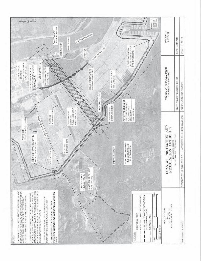
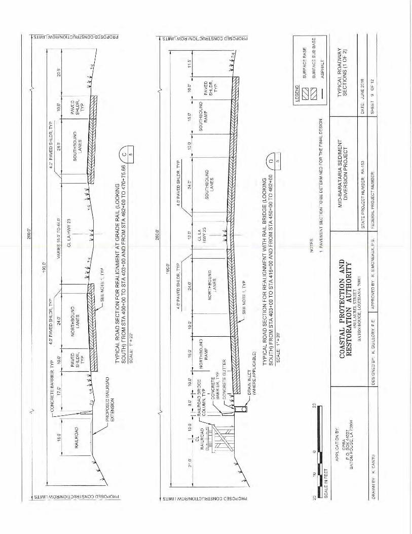
a. Project Name and/or Title: Mid-Barataria Sediment Diversion (BA-153)
b. Project Type: Non-Residential
c. Source of Funding: Federal
d. What will be done for the proposed project?
Bridge/Road Home Site/Driveway Pipeline/Flow Line Rip Rap/Erosion Control
Bulkhead/Backfill Levee Construction Plug/Abandon Site Clearance
Drainage Improvements Dredging Production
Barge/Structure Subdivision
Drill Barge/Structure Prop Washing Vegetative Plantings Wharf/Pier/Boathouse
Drill Site Pilings Remove Structures
Fill Marina Major Industrial/Commercial
Other: excavation for conveyance channel / levee tie-ins
e. Why is the proposed project needed?
Consistent with the Louisiana Trustee Implementation Group's Strategic Restoration Plan (SRP) and Environmental Assessment #3 and the Louisiana Coastal Master Plan (CMP), the purpose is to restore for injuries caused by the Deepwater Horizon oil spill by implementing a large-scale sediment diversion in the Barataria Basin that will reconnect and re-establish sustainable deltaic processes between the Mississippi River and the Barataria Basin through the delivery of sediment, freshwater, and nutrients to support the long-term viability of existing and planned coastal restoration efforts. The proposed project is needed to help restore habitat and ecosystem services injured in the northern Gulf of Mexico as a result of the DWH oil spill.
Step 9 of 15 - Project Status
a. Proposed project start date: 01/01/2020 Proposed project completion date: 01/01/2025
b. Is any of the project work in progress?
No Yes

c. Is any of the project work complete?
No Yes
Step 10 of 15 - Structures, Materials, and Methods for the Proposed Project
a. Excavations
3,850,000 yd3 288 Acres
b. Fill Areas
4,152,001,00 yd3 554.30 Acres
c. Fill Materials
Concrete: 371,293 yd3 Rock: 65,676 yd3
Crushed Stone or Gravel: 102,290 yd3 Sand: yd3
Excavated and placed onsite: 1,100,000 yd3 Hauled in
topsoil/Dirt: 584,035 yd3
Excavated and hauled offsite: 2,300,000 yd3
Other: Nourishment Disposal Area 2,300,000.00yd3
d. What equipment will be used for the proposed project?
Airboat Bulldozer/Grader Marsh Buggy
Backhoe Dragline/Excavator Other Tracked or Wheeled Vehicles
Barge Mounted Bucket Dredge Handjet Self Propelled Pipe Laying
Barge
Barge Mounted Drilling Rig Land Based Drilling Rig Tugboat
Other:
Step 11 of 15 - Project Alternatives
a. Total acres of wetlands and/or waterbottoms filled and/or excavated.
484.6 acres

b. What alternative locations, methods, and access routes were considered to avoid impact to wetlands and/or waterbottoms?
As part of the engineering and design phase, construction and staging areas would consider the use of existing access roads and drives to minimize impacts to wetlands. See pp. 16-19 for additional information on alternatives (location, capacity, and structure type) analysis conducted since 1996 that resulted in the location of the Mid-Barataria Sediment Diversion at River Mile 60.7 with a capacity of 75,000 cfs.
c. What efforts were made to minimize impact to wetlands and/or waterbottoms?
The analysis of the Mid-Barataria Sediment Diversion was developed using the minimum construction footprint to maximize the conveyance of sediment-laden water from the Mississippi River to the mid-Barataria Basin. The gravity conveyance alignment was developed for efficient sediment conveyance between the river and the basin. Best Management Practices (BMPs) are being developed for access routes to minimize disturbance to wetlands between the MR&T and NOV levees.
d. How are unavoidable impacts to vegetated wetlands to be mitigated?
The project is self-mitigating. The purpose of the Project is to reconnect and re-establish the natural or deltaic sediment deposition process between the Mississippi River and the Barataria Basin as a long-term resilient, sustainable strategy to reduce land loss rates and sustain DWH injured wetlands through the delivery of sediment, freshwater, and nutrients.
Step 12 of 15 - Permit Type and Owners
a. Are you applying for a Coastal Use Permit?
No Yes
b. Are you the sole landowner/oyster lease holder?
No Yes
The applicant is an owner of the property on which the proposed described activity is to occur.
The applicant has made reasonable effort to determine the identity and current address of the owner(s) of the land on which the proposed described activity is to occur, which included, a search of the public records of the parish in which the proposed activity is to occur.
The applicant hereby attests that a copy of the application has been distributed to the following landowners/oyster lease holders.
Landowner/Oyster Lease
c. Does the project involve drilling, production, and/or storage of oil and gas?

No Yes
Step 13 of 15 - Maps and Drawing Instructions
USACE_Figure_Jurisdictional_Wetlands_and_WOTUS.pdf 03/19/2018 08:20:03 AM
Pages_from_JD_final_2012_02806_1_SY_Davoli.pdf 03/19/2018 08:20:59 AM
MBSDBA-153PermitSet.pdf 06/22/2016 03:29:40 PM
P20131098NeedsandAlternativesJustification.pdf 06/22/2016 03:29:40 PM
RevisedP20131098_MVN-2012-02806-ETTSupplementInfo.pdf 06/22/2016 03:29:41 PM
Supplementalfigures2.pdf 06/22/2016 03:29:41 PM
FEE_WAIVER_REQUEST_LETTER_07-24-13.pdf 07/24/2013 01:31:40 PM
Step 14 of 15 - Payment
The fee for this permit is: $100.00
Step 15 of 15 - Payment Processed
Applicant Information
Applicant Name: COASTAL PROTECTION & RESTORATION AUTHORITY OF LOUISIANA (CPRA)
Address: 150 Terrace AvenueCity/State/Zip: Baton Rouge, LA 70802
Application Information
Permit Type: CUP
To the best of my knowledge the proposed activity described in this permit application complies with, and will be conducted in a manner that is consistent with the Louisiana Coastal Resources Program. If applicable, I also certify that the declarations in Step 12c, oil spill response, are complete and accurate.
View Comments related to this project

-404
and
10/4
04


P20131098 Needs and Alternatives Justification
Background The proposed sediment diversion project was initially identified as part of the Coastal Wetlands Planning, Protection and Restoration Act (CWPPRA) funded Mississippi River Sediment, Nutrient and Freshwater Redistribution Study (MRSNFR) in 2000. Subsequent studies ensued relevant to the sediment diversion alternatives analysis including location, diversion flow, and ancillary features such as various combinations of marsh creation and sediment introduction. In 2001, the CWPPRA task force approved study of the Delta Building Diversion at Myrtle Grove (BA-33) with the National Marine Fisheries Service (NMFS) as the federal sponsor; a Notice of Intent (NOI) to prepare an Environmental Impact Statement (EIS) was published in the Federal Register in 2002 and the public scoping resulted in a range of diversion operation for further analysis. The project was evaluated as a near-term critical restoration feature in the U.S. Army Corps of Engineers (USACE) Louisiana Coastal Area (LCA) Final Programmatic EIS dated 2005 and included in the LCA restoration plan. The Water Resources Development Act (WRDA) of 2007 authorized USACE to carry out the Medium Diversion at Myrtle Grove in accordance with the LCA restoration plan. As a result, the CWPPRA project was de-authorized in 2008 and transferred to USACE for implementation. Also in 2007, the State of Louisiana included the CWPPRA Mississippi River Diversion at Myrtle Grove with Dedicated Dredging in the Comprehensive Master Plan for a Sustainable Coast (Master Plan). The Master Plan was updated in 2012 and the Mid-Barataria Sediment Diversion was identified as a project in the First Implementation Period (2012-2031). In 2016, the Natural Resources Damage Assessment (NRDA) Trustees established Mississippi River Diversions as an approved restoration alternative to restore resources injured by the Deepwater Horizon oil spill. Myrtle Grove Freshwater Diversion (Siphon) (BA-24) (1996-1998) The Myrtle Grove Freshwater Diversion was moved forward under CWPPRA for further study with NMFS as the federal sponsor. Conceptual design consisted of a multiple pipe system capable of delivering up to 2,100 cfs of water from the Mississippi River to the back marsh area west of Myrtle Grove. Myrtle Grove Ecosystem Restoration Project—Coast 2050 (1997-1998) The Louisiana Coastal Wetlands Conservation and Restoration Task Force (a federal-state multi-agency partnership), in partnership with the Wetlands Conservation and Restoration Authority, published Coast 2050: Toward a Sustainable Coastal Louisiana in December 1998. Coast 2050 set forth a new approach to 1) sustain a coastal ecosystem with the essential functions and values of the natural ecosystem; 2) restore the ecosystem to the highest practicable acreage of productive and diverse wetlands; and 3) accomplish restoration through an integrated program that has multiple use benefits for all coastal Louisiana communities and resources. The 15,000 cfs delta-building diversion at Myrtle Grove was identified for near-term implementation (1-5 years) following completion of the Mississippi River Sediment, Nutrient, and Freshwater Redistribution (MRSNFR) Feasibility Study. The rationale was the Myrtle Grove diversion would provide information to assist in the planning of the next Mississippi River diversion.

Mississippi River Sediment, Nutrient, and Freshwater Redistribution (MRSNFR) Study (draft report & environmental resources document dated July 2000) The CWPPRA Task Force funded the MRSNFR feasibility study with USACE as study lead. A Myrtle Grove Sediment Diversion with a capacity of 15,000 cfs through gated culverts at the Mississippi River was included as a major sediment diversion in the Initial Alternatives. Also included in the Initial Alternatives was a 5,000 cfs Myrtle Grove Freshwater Diversion through a siphon. The screening process resulted in both the Myrtle Grove Sediment Diversion and the Myrtle Grove Freshwater Diversion at Ironton being carried forward into the Intermediate Array of Alternatives. The Myrtle Grove Freshwater Diversion would run at a capacity of 5,000 cfs and freshen or stabilize salinities in the Round Lake/Lake Laurier vicinity. Although not a sediment diversion, it was expected that this diversion would introduce sediment into the Barataria Basin, creating over 1,400 ac of marsh and sustaining approximately 6,500 ac of emergent wetlands over 50 years. The total cost was estimated to be $29,679,827. Located at River Mile 59 AHP, the diversion structure would consist of four 10 ft x 10 ft gated concrete box culverts approximately 400 ft long under LA 23. The highway would be relocated closer to the railroad so the culverts could be placed under both facilities. In order to efficiently capture freshwater, the invert of the entrance channel would be placed at a depth of -10 NGVD with a radius of 130 ft; the conveyance channel would run 6,000 feet from the entrance channel to the outlet channel and would be 100 feet wide. Parallel guide levees would be constructed to maintain hurricane protection and a pump station would be constructed to provide local drainage. The Myrtle Grove Sediment Diversion would run at a capacity of 15,000 cfs to freshen the lower Barataria Basin. Located at RM 59 AHP, the diversion structure would consist of five 16 ft x 16 ft gated concrete box culverts approximately 400 feet long under LA 23. The highway would be relocated closer to the railroad so the culverts could be placed under both facilities. In order to efficiently capture sediment, the invert of the entrance channel would be placed at a depth of -15 ft NGVD with a radius of 450 feet and proceed 800 feet to 1,000 feet into the box culverts for transport to the basin. A channel with a 230 ft bottom would be dredged to Wilkinson Canal; this channel would bend with a radius of 700 feet as it approached the canal in order to provide better flow conditions. Channel closures would be placed in channels intersecting Wilkinson Canal. Approximately 6,000 ac of marsh would be created; at the end of 50 years 12% of the 1990 marsh acreage would be lost but there would still be approximately 28,000 more acres of marsh than if the diversion had not been implemented. A diversion at Myrtle Grove with locks was also evaluated. A 15 ft long pilot channel would be excavated from the Mississippi River to Barataria Bay. The bottom width of the pilot channel would be 200 feet and the invert would be -10 ft NGVD. Two 45 ft x 130 ft x 830 ft lock chambers would be constructed in the initial project year with additional chambers constructed in years 10 and 35. Approximately 5 years after construction, a closure would be constructed across the Mississippi River channel in order to divert river flow down the pilot channel. Without locks, approximately 70% of Mississippi River flow and sediment would be diverted into the Barataria Basin.

Myrtle Grove Ecosystem Restoration Project (CWPPRA) Primary purpose of study, conducted under MRSNFR, was identification of the recommended plan to provide maximum benefit to the study area while taking into account sustainability and cost. The project objective was creation of a sustainable, functional ecosystem with a focus on sediment delivery through the restoration of fresh and intermediate marshes in the upper, highly deteriorated portions of the study area and to restore marsh and reduce land loss rates in the southern portions of the basin and reduce average annual salinities throughout the study area. Study focused on a diversion located on the right descending bank of the Mississippi River between RM 61.3 and 60.8. The study integrated the alternatives identified in the MRSNFR. Studied flow rates included 2,500 cfs, 5,000 cfs, and 15,000 cfs in addition to dedicated dredging. Myrtle Grove—LCA Recommended Restoration Plan (2000-2005) The study team defined the primary area of wetland restoration to be bounded on the east by the Citrus Lands levee, on the north by the southern extent of “The Pen,” on the west by the Barataria Bay Waterway and the Bayou Grande Cheniere ridge, and on the south by the southern extents of Round Lake and Lake Laurier. The team adopted the LCA proposed alternatives for diversion capacities of 5,000 cfs and 15,000 cfs and modified an LCA proposed alternative to an operation of 5,000 cfs 4 out of 5 years and 15,000 cfs in the 5th year. The team also proposed a diversion capacity of 2,500 cfs. As part of the LCA feasibility study, a total of five operation scenarios were evaluated for Myrtle Grove. These scenarios were: 1) a 5,000 cfs diversion; 2) a 15,000 cfs diversion; 3) a 38,000 cfs diversion with sediment enrichment; 4) a 75,000 cfs diversion with sediment enrichment; and 5) a 150,000 cfs diversion with sediment enrichment. Plan formulation resulted in a medium diversion (5,000 cfs – 15,000 cfs) and a large diversion (greater than 15,000 cfs) carried forward. Following further evaluation, the medium diversion was selected as the alternative to carry forward. As proposed in the LCA feasibility study, the Medium Diversion at Myrtle Grove with Dedicated Dredging considered an operation range between 2,500 cfs and 15,000 cfs to create up to 19,700 new acres of wetlands. This diversion would be operated in conjunction with the Davis Pond Freshwater Diversion, which is authorized for control of salinities in the Barataria Basin; the operation of the Davis Pond project would be modified in order to achieve the goals of the Myrtle Grove project. A total of 19 to 23 sites would be selected for the placement of dredged material to create a total of 6,500 acres of marsh; approximately 2 million cubic yards of material would be dredged from the Mississippi River for the dedicated marsh creation. CWPPRA Delta Building Diversion at Myrtle Grove (BA-33) (2001-2008) In 2001, the CWPPRA Task Force approved feasibility study for a project titled Delta Building Diversion at Myrtle Grove with NMFS as the federal sponsor. As proposed, this project would combine a freshwater diversion of the Mississippi River in the vicinity of Myrtle Grove with dedicated dredging from borrow sites in the Mississippi River to create marsh in the vicinity of Bayou Dupont, the Bayou Barataria Waterway, and/or the Wilkinson Canal. A NOI to prepare an EIS was published in the Federal Register

and the public scoping resulted in a range of diversion operations from 2,500 cfs to 15,000 cfs for further analysis. Per the project fact sheet, the project would install five 16 ft x 16 ft gated box culverts on the right descending bank of the Mississippi River in the vicinity of Myrtle Grove. The intake structure would be set at -15 ft NGVD and convey a maximum of 15,000 cfs to the outfall at the basin. Sediment capture would be maximized through a reverse curve inflow channel. Other project features would include a conveyance channel with parallel mainline flood control levees, and outflow channel with guide levees, and, potentially, a pump station. In 2006, the process began to de-authorize the project and transfer it from CWPPRA to USACE’s LCA program. The rationale was the project was beyond traditional CWPPRA efforts in terms of scope and cost; also, a Medium Diversion at Myrtle Grove with Dedicated Dredging project was identified as a critical near-term restoration project in the LCA Chief’s Report. Louisiana Master Plan for a Sustainable Coast (2007) A Technical Group of scientists evaluated conceptual scenarios for Mississippi River diversions in 2006 at the “Envisioning the Future of the Gulf Coast” symposium. A freshwater diversion at Myrtle Grove was recommended. The Mississippi River Diversion at Myrtle Grove with Dedicated Dredging was evaluated in the Master Plan; the evaluated diversion would operate at a flow between 2,500 cfs to 15,000 cfs to transport freshwater from the Mississippi River to the basin and dredged material from the river would be transported to the Barataria Basin via pipeline. Medium Diversion at Myrtle Grove with Dedicated Dredging (LCA, 2008-2014) WRDA 2007 included an authorization for USACE to prepare a feasibility study and EIS for the Medium Diversion at Myrtle Grove with Dedicated Dredging under the LCA program. This project was conditionally authorized in the 2005 LCA Chief’s Report, pending the completion of a feasibility study. For the Myrtle Grove cost-shared study, the project was described as a freshwater diversion ranging from 2,500 cfs to 15,000 cfs coupled with dedicated dredging to create up to 19,700 ac of new wetlands. The dog-legged alignment, referred to as Original USACE Alignment at RM 60.2, was designed to carry a flow of 15,000 cfs to the basin; the sediment/water ratio (SWR) was 0.26. A Modified Alignment of a straight channel from river to basin, located at RM 60.7, was modeled with capacities of 15,000 cfs, 45,000 cfs, and 75,000 cfs. The results were published in 2011 in a report titled, “Myrtle Grove Delta Building Diversion Modeling Effort in Support of the LCA Medium Diversion at Myrtle Grove with Dedicated Dredging Project Data Collection, Preliminary Design and Modeling Initiative.” Louisiana Comprehensive Master Plan for a Sustainable Coast (2012) Modeling conducted for the evaluation of projects against the Future Without Action scenario showed that sediment diversions are essential to sustaining coastal Louisiana. The 2012 Master Plan focused on sediment diversions, rather than freshwater diversions, as a land-building restoration tool. A 50,000 cfs sediment diversion at Myrtle Grove was included in the First Implementation Period (2012-2031).

BA-153, State Only E&D (2012-2014) CPRA entered into a contract with HDR Engineering in 2012 to provide services for the design of the LCA recommended 75,000 cfs diversion structure at RM 60.7 to capture and transport sediment and freshwater from the Mississippi River and convey it to the mid-Barataria Basin through a constructed channel. The project utilized the SWR results and Modified Alignment from the State-NGO modeling. Programmatic Damage Assessment and Restoration Plan (2016) Under the Oil Pollution Act (OPA), the Trustees evaluated injuries to natural resources and natural resource services and then identified the actions to restore, replace, or acquire natural resources or services equivalent to those injured by the Deepwater Horizon BP Spill. When implemented, the goal for these actions is to return the natural resources and natural resource services to the condition they would have been in if the incident had not occurred. OPA defines natural resource services as “the functions performed by a natural resource for the benefit of another natural resource (ecological services) and/or the public.” This evaluation was documented in a Programmatic Damage Assessment and Restoration Plan (PDARP). A total of three (3) action alternatives were evaluated along with the No Action Alternative. Alternative A, Comprehensive Integrated Ecosystem Restoration, emphasizes the broad ecosystem benefits that can be realized through coastal habitat restoration in combination with resource-specific restoration; this is the preferred alternative. Alternative B focuses on restoring as directly as practical for assessed injuries. Alternative C defers restoration plan development in favor of continued injury assessment with development of a comprehensive plan at a later date. Alternative D is the natural recovery/no-action alternative. The alternatives were evaluated under the following OPA standards: 1) cost; 2) extent to which goals and objectives are met; 3) likelihood of success; 4) extent of preventing future injury and avoiding collateral injury as a result of implementation; 5) extent to which more than one natural resource and/or service is benefitted; 6) effect on public health and safety; and 7) consistency with programmatic Trustee goals and the restoration types. The Trustees developed four (4) programmatic goals for restoration: 1) Restore and Conserve Habitat; 2) Restore Water Quality; 3) Replenish and Protect Living Coastal and Marine Resources; and 4) Provide and Enhance Recreational Opportunities. Restoration types were developed as sub-categories to the larger programmatic goals. The two (2) restoration types under Restore and Conserve Habitat are: 1) Wetlands, Coastal, and Nearshore Habitats and 2) Habitat Projects on Federally Managed Lands. Both of these restoration types were proposed to benefit habitats as well as injured species of fish and invertebrates in the water column, marine mammals, and birds by providing food, shelter, breeding, and nursery habitat. Goals of the Wetlands, Coastal, and Nearshore Habitats Restoration Type are to: 1) restore a variety of interspersed and ecologically connected coastal habitats to maintain ecosystem diversity with a particular focus on maximizing ecological functions for the range of resources injured by the spill; 2) restore for injuries in habitats in the geographic areas where the injuries occurred while considering

approaches that provide resiliency and sustainability; and 3) restoration of habitats in appropriate combinations for any given geographic area by considering design factors such as connectivity, size, and distance between projects to address injuries to the associated living coastal and marine resources and restore the ecological functions provided by those habitats. Specific projects were not evaluated in the PDARP; however, Under Alternative A, controlled Mississippi River diversions, such as MBSD, are one such restoration approach for implementation to accomplish the goals of this restoration type.

11
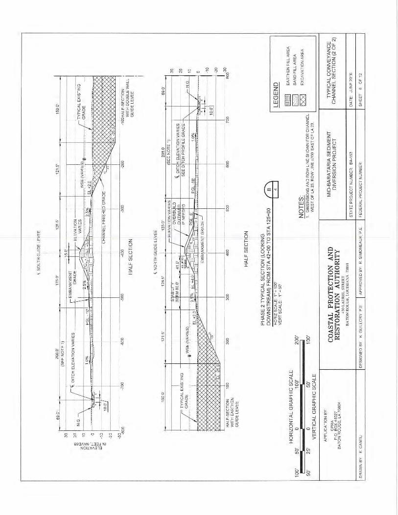
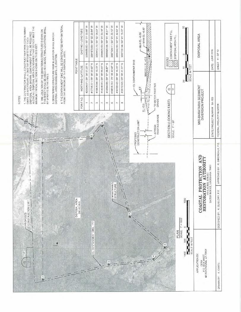
5a. Describe the Project The Mid-Barataria Sediment Diversion (MBSD) is one of 33 conceptual projects identified by CPRA for the first implementation period (2012-2031) in Louisiana’s Comprehensive Master Plan for a Sustainable Coast (2012 Master Plan). The Project footprint is from the Mississippi River to the mid-Barataria Basin, just west of the back levee, spanning a length of approximately two miles and width of approximately 1600 feet for the gravity conveyance structure and appurtenant structures. The Project consists of the construction of an intake control structure on the right descending bank of the Mississippi River at River Mile 60.7, through a section of the existing Mississippi River and Tributaries (MR&T) levee. The structure would be operated to reestablish the connection between the Mississippi River and the mid-Barataria Basin by transporting sediment, freshwater, and nutrients through the gravity conveyance structure, leading across land and through the future federal New Orleans to Venice (NOV) Hurricane Protection Levee, to an outfall or receiving area in the mid-Barataria Basin. The outfall area is located south of the Bayou Dupont Sediment Delivery Project (BA-39), the Mississippi River Long Distance Sediment Pipeline (BA-43EB), and the Bayou Dupont Marsh and Ridge Creation (BA-48). Additional Project features include relocation and replacement of segments of Louisiana Highway 23 and the New Orleans Gulf Coast Rail Road over the gravity conveyance structure. The project also incorporates a pump station to be located in the northwestern portion of the Project area. Forced drainage is currently provided by Wilkinson Canal Pump Station located near Myrtle Grove to the south of the project area. The Project will require the modification of internal drainage collection swales and the construction of a new drainage pump station north of the conveyance channel in order to capture and convey area drainage north of the channel to the Barataria Basin. Right-of-way and road access will be required for the construction and maintenance of the pump station. Relocations of water and electrical utility lines will be needed in order to accommodate the construction and operation of the diversion channel and the proposed LA 23 and New Orleans Gulf Coast Rail Road bridges. A 22 inch crude oil pipeline is located immediately west of the proposed channel outfall. All infrastructure and utility improvements and relocations will be based upon continued service during construction and will be designed and constructed using utility owner criteria and guidelines and addressing hurricane criteria during interim and final phases of construction. An Operations and Maintenance Plan will be developed for the Project prior to construction. An Adaptive Management Plan will be developed to maximize sediment transport from the Mississippi River to the mid-Barataria Basin to reduce land loss rates and sustain wetlands through the delivery of sediment, freshwater, and nutrients. The Adaptive Management Plan would monitor the diversion control structure and outfall area and allow for variable flow rates to respond to seasonal, sediment, and basin conditions, maximizing the benefits of sediment transport for restoration. Step 8.c. Funding CPRA anticipates construction the Mid-Barataria Sediment Diversion with Natural Resource Damage Assessment (NRDA) funds allocated to the State of Louisiana by the Deepwater Horizon BP Spill Consent Decree (dated April 2016).
12
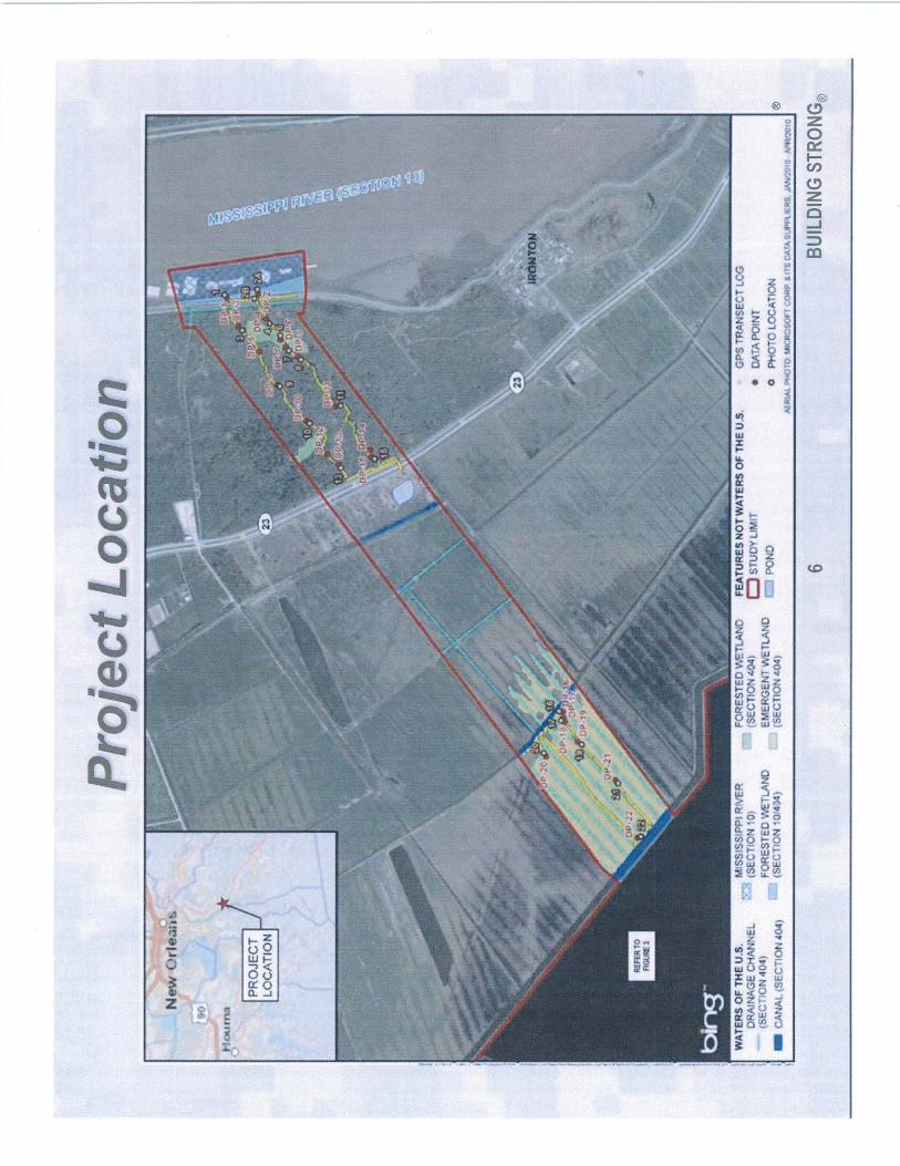
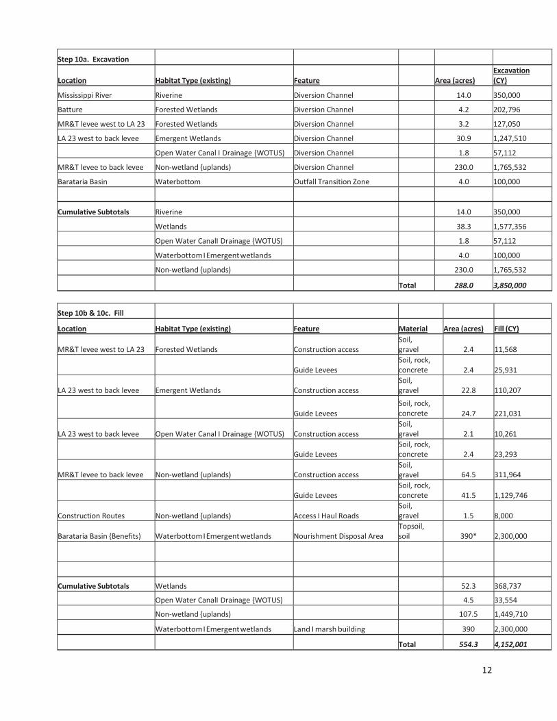
Step 10a. Excavation Location
Habitat Type (existing)
Feature
Area (acres)
Excavation (CY)
Mississippi River Riverine Diversion Channel 14.0 350,000
Batture Forested Wetlands Diversion Channel 4.2 202,796
MR&T levee west to LA 23 Forested Wetlands Diversion Channel 3.2 127,050
LA 23 west to back levee Emergent Wetlands Diversion Channel 30.9 1,247,510 Open Water Canal I Drainage {WOTUS) Diversion Channel 1.8 57,112
MR&T levee to back levee Non-wetland {uplands) Diversion Channel 230.0 1,765,532
Barataria Basin Waterbottom Outfall Transition Zone 4.0 100,000
Cumulative Subtotals Riverine 14.0 350,000 Wetlands 38.3 1,577,356 Open Water CanalI Drainage {WOTUS) 1.8 57,112 Waterbottom I Emergent wetlands 4.0 100,000 Non-wetland {uplands) 230.0 1,765,532 Total 288.0 3,850,000
Step 10b & 10c. Fill
Location Habitat Type (existing) Feature Material Area (acres) Fill (CY) MR&T levee west to LA 23
Forested Wetlands
Construction access
Soil, gravel
2.4
11,568
Guide Levees
Soil, rock, concrete
2.4
25,931
LA 23 west to back levee
Emergent Wetlands
Construction access
Soil, gravel
22.8
110,207
Guide Levees
Soil, rock, concrete
24.7
221,031
LA 23 west to back levee
Open Water Canal I Drainage {WOTUS)
Construction access
Soil, gravel
2.1
10,261
Guide Levees
Soil, rock, concrete
2.4
23,293
MR&T levee to back levee
Non-wetland {uplands)
Construction access
Soil, gravel
64.5
311,964
Guide Levees
Soil, rock, concrete
41.5
1,129,746
Construction Routes
Non-wetland {uplands)
Access I Haul Roads
Soil, gravel
1.5
8,000
Barataria Basin {Benefits)
Waterbottom I Emergent wetlands
Nourishment Disposal Area
Topsoil, soil
390*
2,300,000
Cumulative Subtotals Wetlands 52.3 368,737 Open Water CanalI Drainage {WOTUS) 4.5 33,554 Non-wetland {uplands) 107.5 1,449,710 Waterbottom I Emergent wetlands Land I marsh building 390 2,300,000 Total 554.3 4,152,001

13
10b. and 10c. Supplemental Fill Information Note: Due to preliminary design stage, the amount of fill material by type (e.g., soil, rock, concrete, etc.) is approximate. * Excavated from channel and placed in Barataria Basin. 11a. Total acres of wetlands and/or waterbottoms filled and/or excavated:
Wetlands excavated = 38.3 acres Wetlands filled = 52.3 acres Waterbottom excavated = 4.0 acres Waterbottom filled = 390 acres

USGS QUAD MAPLAFITTE, LA
MRC 29090-F12012
USGS QUAD MAPPHOENIX, LAMRC 29089-F8
2012
USGS QUAD MAPTHREE BAYOU BAY, LA
MRC 29090-E12012
USGS QUAD MAPLAKE LAURIER, LA
MRC 29089-E82012
UV23
PLAQUEM
INES
JEFFERSON
MID-BARATARIASEDIMENT DIVERSION
(BA-153) PROJECT
_̂
§̈¦12§̈¦59§̈¦55
§̈¦10
GULF OFMEXICO
LEGEND oFOR PERMIT COORDINATION ONLY – NOT FOR CONSTRUCTION

23
23
MISS
ISSIP
PI R
IVE
R
BARATARIA BASIN
CANCIENNESILT LOAM
CARVILLE, CANCIENNE,AND SCHRIEVER SOILS,FREQUENTLY FLOODED
AQUENTS, DREDGED,FREQUENTLY
FLOODED
LAFITTEMUCK
URBANLAND
AQUENTS,DREDGED
HARAHANCLAY
SCHRIEVERCLAY
WESTWEGOCLAY
LAFITTEMUCK
CANCIENNESILTY
CLAY LOAM
HARAHANCLAY
MID-BARATARIASEDIMENT DIVERSION
(BA-153) PROJECTLEGENDWATERS OF THE U.S. NOT WATERS OF THE U.S.
FOR PERMIT COORDINATION ONLY – NOT FOR CONSTRUCTION