Embed Size (px)
Citation preview

August 2006
Volume 68 Number 2
ISSN 1090-6924A Publication of the National
Speleological Society
JOURNAL OF
CAVE AND KARST
STUDIES
CAVE SURVEYOR AS MICROBIOLOGIST
Editor
Malcolm S. FieldNational Center of Environmental Assessment (8623D)
Office of Research and Development
U.S. Environmental Protection Agency
1200 Pennsylvania Avenue NW
Washington, DC 20460-0001
202-564-3279 Voice 202-565-0079 FAX
Production Editor
James A. PisarowiczWind Cave National Park
Hot Springs, SD 57747
605-673-5582
BOARD OF EDITORS
Anthropology
Patty Jo WatsonDepartment of Anthropology
Washington University
St. Louis, MO 63130
Conservation-Life Sciences
Julian J. Lewis & Salisa L. LewisLewis & Associates LLC
Cave, Karst & Groundwater Biological Consulting
17903 State Road 60
Borden, IN 47106-8608
812-283-6120
Earth Sciences-Journal Index
Ira D. SasowskyDepartment of Geology
University of Akron
Akron, OH 44325-4101
330-972-5389
Exploration
Paul BurgerCave Resources Office
3225 National Parks Highway
Carlsbad, NM 88220
(505)785-3106
Paleontology
Greg McDonaldGeologic Resource Divison
National Park Service
P.O. Box 25287
Denver, CO 80225
303-969-2821
Social Sciences
Joseph C. DouglasHistory Department
Volunteer State Community College
1480 Nashville Pike
Gallatin, TN 37066
615-230-3241
Book Reviews
Arthur N. Palmer & Margaret V. PalmerDepartment of Earth Sciences
State University of New York
Oneonta, NY 13820-4015
607-432-6024
Proofreader
Donald G. Davis
JOURNAL ADVISORY BOARD
Calvin Alexander Barbara am Ende
Hazel A. Barton Carol Hill
Horton Hobbs III Julia James
Kathy Lavoie Joyce Lundberg
Stephen Worthington
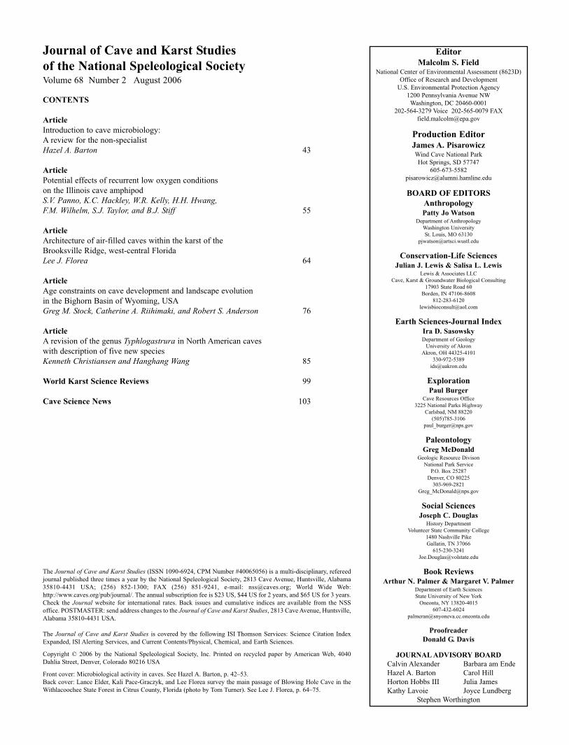
Journal of Cave and Karst Studies
of the National Speleological SocietyVolume 68 Number 2 August 2006
CONTENTS
Article
Introduction to cave microbiology:
A review for the non-specialist
Hazel A. Barton 43
Article
Potential effects of recurrent low oxygen conditions
on the Illinois cave amphipod
S.V. Panno, K.C. Hackley, W.R. Kelly, H.H. Hwang,F.M. Wilhelm, S.J. Taylor, and B.J. Stiff 55
Article
Architecture of air-filled caves within the karst of the
Brooksville Ridge, west-central Florida
Lee J. Florea 64
Article
Age constraints on cave development and landscape evolution
in the Bighorn Basin of Wyoming, USA
Greg M. Stock, Catherine A. Riihimaki, and Robert S. Anderson 76
Article
A revision of the genus Typhlogastrura in North American caves
with description of five new species
Kenneth Christiansen and Hanghang Wang 85
World Karst Science Reviews 99
Cave Science News 103
The Journal of Cave and Karst Studies (ISSN 1090-6924, CPM Number #40065056) is a multi-disciplinary, refereed
journal published three times a year by the National Speleological Society, 2813 Cave Avenue, Huntsville, Alabama
35810-4431 USA; (256) 852-1300; FAX (256) 851-9241, e-mail: [email protected]; World Wide Web:
http://www.caves.org/pub/journal/. The annual subscription fee is $23 US, $44 US for 2 years, and $65 US for 3 years.
Check the Journal website for international rates. Back issues and cumulative indices are available from the NSS
office. POSTMASTER: send address changes to the Journal of Cave and Karst Studies, 2813 Cave Avenue, Huntsville,
Alabama 35810-4431 USA.
The Journal of Cave and Karst Studies is covered by the following ISI Thomson Services: Science Citation Index
Expanded, ISI Alerting Services, and Current Contents/Physical, Chemical, and Earth Sciences.
Copyright © 2006 by the National Speleological Society, Inc. Printed on recycled paper by American Web, 4040
Dahlia Street, Denver, Colorado 80216 USA
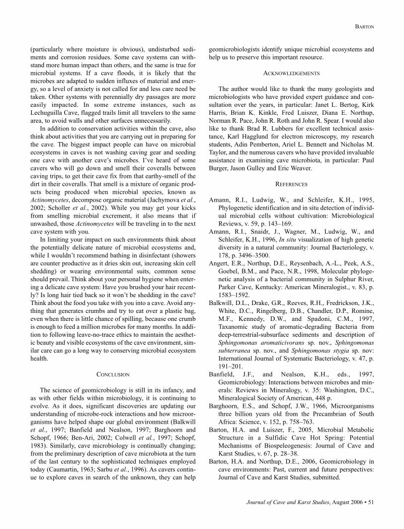
Front cover: Microbiological activity in caves. See Hazel A. Barton, p. 42–53.
Back cover: Lance Elder, Kali Pace-Graczyk, and Lee Florea survey the main passage of Blowing Hole Cave in the
Withlacoochee State Forest in Citrus County, Florida (photo by Tom Turner). See Lee J. Florea, p. 64–75.
Journal of Cave and Karst Studies, August 2006 • 43
Hazel A. Barton – Introduction to cave microbiology: A review for the non-specialist. Journal of Cave and Karst Studies, v. 68, no. 2, p. 43–54.
INTRODUCTION
The study of cave microbiology deals with the microscopic life
that resides in caves. Microscopic life has historically been
grouped into the Monera, one of the five kingdoms of life, and
a pretty broad group that includes any microscopic organism
that lacks a nucleus; also historically known as the prokaryotes
(Whittaker, 1969). The protozoa, which are also microscopic
and include such organisms as the amoeba, do contain a nucle-
us and are classed within the eukaryotes (Whittaker, 1969).
While viruses are also of microscopic, they are not technically
alive and, although fascinating, will not be discussed within
the scope of this review. Animals, plants and fungi all consti-
tute the forms of life that can be seen with the naked eye
(macroscopic) and are nucleus-containing eukaryotes.
A BRIEF HISTORY OF MICROBIOLOGY
During the Dark Ages (c.400-700 AD) devastating dis-
eases, such as the Black Death, ravaged humanity. At that time,
there was only a vague inkling in medicine that these maladies
were transmitted by an infectious agent. Rather, physicians
believed in mystical spirits and lethal miasmas, which were
responsible for such pestilence. Patients would attempt to ward
off these evil spirits with charms and even flowers; the “pock-
et-full of posies” of the nursery rhyme. These attempts were
somewhat beneficial, although not for immediately obvious
reasons – breathing through containers of dried flowers effec-
tively filtered out the bacteria that were responsible for the
spread of pneumonic plague, perpetuating the myth of evil
vapors.
The first awareness of a microscopic world occurred
around 300 years ago, when Dutch linen merchant Antoni van
Leeuwenhoek devised a rudimentary, hand-made microscope
to look at linen fibers. Leeuwenhoek also used his microscope
to look at other materials; in pond water he saw tardigrades
(for slow-walker), small insect-like organisms he termed ani-
malcules. Eventually, by refining his microscope lens,
Leeuwenhoek went on to describe the first bacteria, which he
saw in his own dental plaque. These bacteria were so small that
it would take two thousand of them stacked end-to-end to tra-
verse the head of a pin, which Leeuwenhoek accurately
described in great detail.
Leeuwenhoek’s animalcules were considered nothing more
than a curiosity for almost 200 years, until the golden age of
microbiology and the work of such luminaries as Pasteur and
Koch. Louis Pasteur wanted to understand the then-accepted
notion of spontaneous generation – that a vital force allowed
life to arise spontaneously in food or wine. In attempting to
define the existence of this vital force, in 1861 Pasteur suc-
cessfully demonstrated that this “vital force” was comprised of
microorganisms in the air. Pasteur subsequently went on to
design ways of killing these organisms in food to prevent
spoilage and developed the technique of pasteurization. Robert
Koch took the principles of Pasteur and other investigators fur-
ther, to show that the same microorganisms that could spoil
food could also cause disease in humans. In 1876 Koch devel-
oped the techniques to identify the causative agent of anthrax.
These techniques became an accepted scientific principle,
termed Koch’s postulates, that can be applied to any pathogen-
ic microbe today, including as recently as in the case of severe
acute respiratory syndrome (SARS) virus. Following the work
of Pasteur, Koch and other eminent microbiologists,
Leeuwenhoek’s animalcules went from being simply a curios-
ity to the basis of the accepted science of microbiology.
With its founding in the medical sciences, the study of
microorganisms has historically concentrated on the impact of
microorganisms on humans, whether through disease or food
spoilage. Nonetheless, in 1887 Sergei Winogradsky made a
groundbreaking discovery; he identified microorganisms that
did not obtain food through photosynthesis, but could use min-
eral energy to literally pull food out of thin air, a process
termed chemolithotrophy (chemical energy – chemo, food
from the environment – litho, to eat – trophy) (Winogradsky,
1887). Despite the identification of microorganisms that defied
INTRODUCTION TO CAVE MICROBIOLOGY:
A REVIEW FOR THE NON-SPECIALISTHAZEL A. BARTON
Department of Biological Sciences, Northern Kentucky University, Highland Heights, KY 41099
Within the past decade there has been an increasing interest in cave microbiota. Such interest has helpedmany speleologists both recognize and understand the importance of microbial species in caves, whichhas led to improvements in cave conservation practices to better conserve these unseen ecosystems.While much information on the metabolic properties and functions of such subterranean ecosystems hasbeen published in the microbial ecology literature, is it sometimes unusable by the non-specialist due totechnical “jargon” and unexplained background information. It is the aim of this review to provide suchbackground information and to explain the current technologies available to study cave microbiota. Indoing so, it is hoped that this material will make the microbiology literature more accessible to interest-ed non-specialists, and open new areas of inquiry in the study of microbial-mineral interactions.
Corresponding author address: Hazel A. Barton, Department of Biological
Sciences, Northern Kentucky University, SC 204D, Nunn Drive, Highland
Heights, KY 41099. Email: [email protected], Phone: 859-572-5303, Fax:
859-572-3956.
44 • Journal of Cave and Karst Studies, August 2006
INTRODUCTION TO CAVE MICROBIOLOGY: A REVIEW FOR THE NON-SPECIALIST
all the previously understood conventions of life (that it relies
on plant-derived material), Winogradsky’s discoveries were
again considered a curiosity, and most microbiologists contin-
ued to concentrate on just a handful of microbes responsible
for human disease. Of course, once again it was proved that an
important microbial activity was overlooked: microbiologists
have since determined that Winogradsky’s chemical-eating
organisms are among the most significant life forms on the
planet (Madigan et al., 2000).
Due to an ability to consume inorganic material for energy,
it is not surprising that microorganisms interact directly with
the geology of our planet. Their activities have helped shape
the global environment in which we live, provided the oxygen
that we breathe and even the oil that drives our economy
(Gold, 1999; Madigan et al., 2000). These microbes also turn
over the essential nutrients, such as carbon (C), nitrogen (N),
sulfur (S) and phosphorus (P), of our ecosystem. Indeed, with-
out the activities of these microorganisms, all macroscopic life
on the planet would cease, while these microbes would survive
quite happily without us (Madigan et al., 2000). Obviously, as
the science of microbiology continues to evolve, our level of
understanding continues to change. This has led to the rapid
inception of extremophile research, which began in 1967 when
Thomas Brock identified bacteria growing in the boiling hot
springs of Yellowstone National Park (Brock, 1967). These hot
conditions demonstrated the extreme conditions under which
microorganisms can survive and the chemistries that can sup-
port their growth (Madigan et al., 2000).
Extremophile research extended the physical and chemical
limits of the environment in which microorganisms can sur-
vive, from the sterilizing temperatures (121° C) of volcanic
vents miles below the surface of the Pacific Ocean, the battery-
acid-like conditions of acid mine drainages, to surviving for
millions of years within crystals of salt (Bond et al., 2000;
Jannasch et al., 1992; Mormile et al., 2003; Shivaji et al.,2004; Thomas and Dieckmann, 2002). Today, almost every
environment imaginable has been examined for the presence
of microorganisms, including, of course, caves (Angert et al.,1998; Barton and Luiszer, 2005; Barton et al., 2004;
Canaveras et al., 2006; Canaveras et al., 2001; Caumartin,
1963; Chelius and Moore, 2004; Cunningham et al., 1995;
Engel et al., 2004; Groth and Saiz-Jimenez, 1999; Groth et al.,1999; Holmes et al., 2001; Hose et al., 2000; Northup and
Lavoie, 2001; Sarbu et al., 1996)
STUDYING MICROORGANISMS IN EXTREME ENVIRONMENTS
In attempting to understand the difficulties in carrying out
microbiology in cave environments, we must go back to the
traditional methods developed by Koch and others in the 1880s
(Koch, 1881). Traditional microbiology techniques rely on
growing a microorganism in a Petri plate, and then identifying
this organism based on the sum of its reactions to obtain food,
respire and break down products (the sum of which is referred
to as metabolism). This is why swabs are often taken when a
bacterial pathogen is thought to be responsible for an infection,
which are used to grow the suspected organism and carry out
metabolic tests for its identification. Unfortunately, there is a
small problem when attempting to grow environmental
microbes: the majority of microorganisms cannot be cultivated
(or as microbiologists say ‘cultured’) in a Petri plate. This is a
phenomenon that microbiologists have known about since the
time of Winogradsky and is based on a simple observation: if
you took a gram of soil, you would be able to see about 5,000
different bacterial species under the microscope, but you
would be lucky if you could induce 50 different species, or 1%
of those observed, to grow (Amann et al., 1995; Amann et al.,1996). This is even worse compared on a global scale: of the
millions of species of bacteria thought to exist on Earth, we
have only been able to cultivate approximately 16,000
(American Type Culture Collection, 2006).
The reason that so many microbes from the environment
are non-culturable is still not completely understood
(Bloomfield et al., 1998; Bogosian et al., 2000; Oliver, 1995;
Whitesides and Oliver, 1997). One reason thought to be impor-
tant comes from the founding of microbiology in medicine;
historically all our cultivation strategies to grow microorgan-
isms are based on the growth characteristics of a small number
of microbes able to infect humans. As a result, the majority of
microbial growth media (the contents of a Petri plate) are
designed, to some extent, to be chemically similar to human
tissues. Indeed, such media is often made from boiling down
meat products with agar to make a nutrient gel. While these
growth media work extremely well for human pathogens, for
environmental microorganisms that grow using unusual chem-
ical reactions, the ‘food’ in these Petri dishes is inappropriate.
To grow these environmental microorganisms requires a cer-
tain amount of guesswork based on the environment from
which they were isolated. It is like trying to decide which cave
food to pack for someone else; everyone has their own prefer-
ence and won’t eat what they don’t like (Amann et al., 1995).
Such non-culturability is likely more pronounced in cave
microorganisms. Without photosynthesis, caves are cut off
from most energy that supports life on the surface, confining
most nutrients to the entrance zone. As a result, cave microor-
ganisms must turn to alternative sources of energy, such as
those found in the atmosphere, or present in the very rock itself
(Barton et al., 2004; Chelius and Moore, 2004; Engel et al.,2003; Northup et al., 2003; Spilde et al., 2005). In adapting to
these extremely starved environments, microorganisms pro-
duce elaborate scavenging mechanisms to pull scarce nutrients
into the cell (Koch, 1997). When these organisms are then
exposed to the rich nutrients of a Petri plate, they cannot turn
down these scavenging mechanisms and quickly gorge them-
selves to death (Koch, 1997, 2001). As a result, microorgan-
isms from starved cave environments may have a hard time
adapting to rapidly changing nutrient status, and simply die
from osmotic stresses (Koch, 1997). Therefore, only a tiny
minority of microorganisms from caves might grow on stan-
dard Petri plates by surviving the changing nutrient conditions,
Journal of Cave and Karst Studies, August 2006 • 45
BARTON
including such species as Pseudomonas and Bacillus species
(Pemberton et al., 2005). Unfortunately these species are
unable to tell us much about the unique microbial processes
taking place in cave environments. In order to overcome these
problems, cave microbiologists have therefore spent a great
deal of time trying to developed improved techniques to grow
cave microorganisms (Gonzalez et al., 2006; Groth et al.,1999; Laiz et al., 1999). Many of these techniques are quite
specialized, and it is unlikely that many microbiologists (such
as those within diagnostic or hospital microbiology labs) have
access to the materials necessary to cultivate rare cave species.
TO GROW OR NOT TO GROW
The non-culturability of microbial species, rather than sim-
ply being a curiosity, poses a significant road-block if you
want to study microbes in natural cave environments.
Fortunately, classical microbiology lost some of its depen-
dence on cultivation in 1977, when Woese was attempting to
understand the genetic differences between microbial species
(Woese and Fox, 1977). Historically, bacteria had been identi-
fied by their growth characteristics and classified based on
their shape and structure. This process of grouping life based
on structure is called taxonomy, and is extremely useful in
determining evolutionary relationships between plants, ani-
mals and insects, etc. (Whittaker, 1969). In bacteria, using
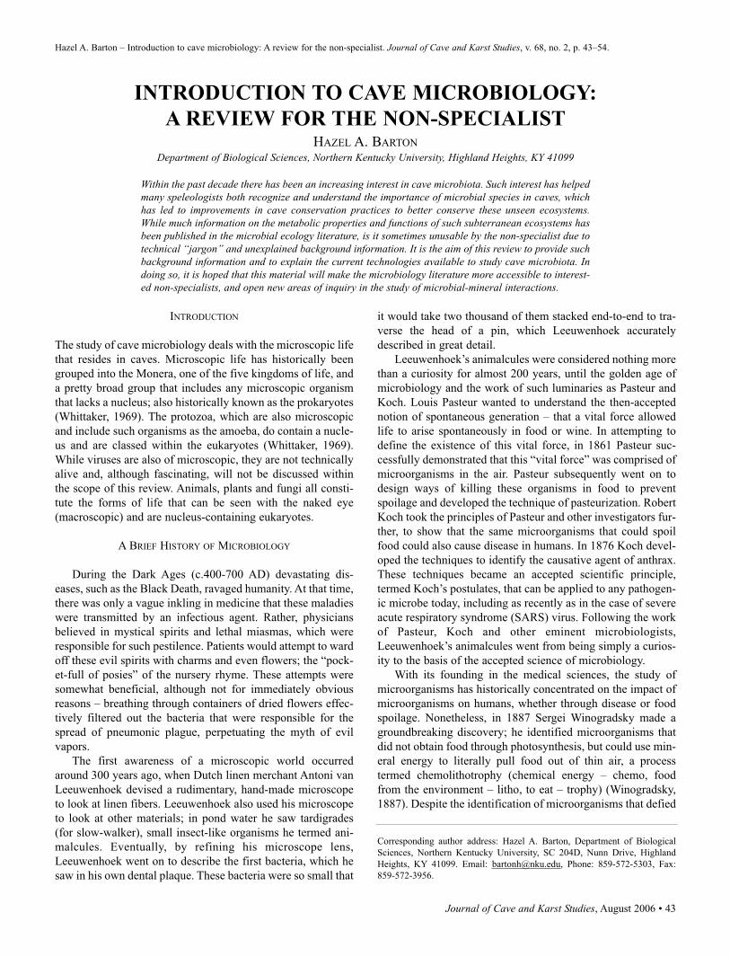
structure to group species turns out to be pretty futile. Bacterial
structures generally represent variations on a theme: either
spheres (technically called cocci) or sausages (bacilli) (Figure
1). As a result, structural taxonomy tended to cluster the bac-
teria into simplified, but artificial groups. We therefore tended
to believe that eukaryotic organisms were the most complex
form of life on Earth, with their broad structural diversity; tax-
onomy identifies over 1,000,000 species of insects alone (May,
1988). Faced with this limitation, Woese decided on a different
approach to resolve bacterial taxonomy. Rather than examin-
ing structure, he looked inside the cells at the DNA.
All of us inherit our genetic information from our parents,
which creates a genetic blueprint of our family tree (blue-eyed
children to blue-eyed parents, etc). By looking at the surnames
in a traditional family tree, it is also quite easy to see who is
related to whom, based on how the surnames change; the same
surname indicates direct descendency, while a change in sur-
name may indicate a marriage into the family. Similarly,
Woese extracted the genetic surnames of a number of microor-
ganisms to determine a family tree for microbial life (Woese
and Fox, 1977). By examining this data, he discovered that
bacteria are much more diverse than we previously suspected.
This diversity, rather than being expressed through structure,
was elaborated through phenomenal capabilities of physiology
and metabolism (Woese, 1987). Woese also identified an
entirely new kind of life using this technique, which was pre-
viously unknown to science. This new form of life looked just
like the bacteria, but the internal genetic controls looked more
like those found in eukaryotic organisms (such as plants and
animals). These organisms were also primarily found in the
harshest conditions; conditions similar to those that may have
been found on early Earth. Woese therefore named this newly
discovered form of life after its potentially ancient origins,
calling them the Archaea (Woese and Fox, 1977). What
Figure 1. Scanning electron microscopy images of common themes in bacterial structure. The two most common struc-
tures are the A) bacilli (in chains, as streptococci) and B) cocci (in pairs, as diplococci).
46 • Journal of Cave and Karst Studies, August 2006
INTRODUCTION TO CAVE MICROBIOLOGY: A REVIEW FOR THE NON-SPECIALIST
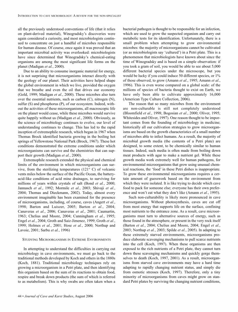
emerged from this work was that, above and beyond the five-
kingdom tree-of-life, there exist domains; the primary groups
of life on Earth. These domains represent 1) the Bacteria
(prokaryotes; lacking a nucleus), 2) the Archaea (also prokary-
otic, but with structures that differentiate them from bacteria
and a DNA structure more similar to a eukaryote), and 3) the
Eukarya (eukaryotes; containing a nucleus) (Figure 2).
BEYOND THE GENETIC TREE
The work of Woese was groundbreaking and shifted our
understanding of what is “life” on Earth. With further refine-
ment by other investigators, it also showed a five-kingdom tree
was an oversimplification, with a current estimate of almost
100 distinct kingdoms (divisions) of life on Earth (Hugenholtz
et al., 1998; Pace, 1997). The new tree also revealed that the
most ancient, most complex and most abundant life on Earth
was actually microscopic (Pace, 1997). This work excited a
number of scientists, including Pace (a microbiologist and
Indiana caver) who decided to look for Woese’s genetic sur-
names in the environment without cultivation (Lane et al.,1985; Stahl et al., 1985). The technique uses the polymerase
chain reaction, or PCR for short, and allows investigators to
make millions of copies from a single piece of DNA. A simi-
lar technique is commonly used today to look for pieces of
genetic information in crime scene investigations, or to detect
the presence of the HIV virus in a patient’s blood. When Pace
used the PCR reaction to look for bacterial genetic surnames
within the environment, it altered our understanding of micro-
bial ecology (Pace, 1997). Rather than generating a tree of lin-
eage from a handful of organisms that could be grown in the
laboratory, this new technique allowed entire microbial
ecosystems to be examined at once without the limitations of
cultivation. Soon, other investigators began using the same
techniques to study environments, and the number of genetic
surnames that were known to science rapidly went from 177 to
the >120,000 that are available today (Maidak et al., 2001).
Such techniques have also improved our ability to estimate the
true diversity of microorganisms (putting entomologists to
shame) with an estimated worldwide population of
200,000,000 different species of bacteria alone (Curtis et al.,2002; Dojka et al., 2000; Torsvik et al., 2002).
IDENTIFICATION WITHOUT CULTIVATION
Using genetic surnames to identify microorganisms (tech-
nically called molecular phylogenetics: molecular – using
DNA molecules; phylogenetics – a reconstruction of the evo-
lutionary history), it gave us tools to identify microorganisms
within an environment without cultivation. Molecular phylo-
Figure 2. A universal tree-of-life based on the genetic comparisons of Woese and Fox (1977), with further refinement by
Pace (1997). The base of the tree emerges from the ‘root’ or last common ancestor of life and splits into the three major
domains of life; the Bacteria, Archaea and Eukarya. The branches represent the (simplified) major divisions (Kingdoms)
of life within each domain.
Journal of Cave and Karst Studies, August 2006 • 47
BARTON
genetics have therefore allowed us to effectively examine
microorganisms in extreme environments; conditions that
would be almost impossible to replicate in the laboratory for
growth using the approach of Koch. These genetic “surnames”
are genes with a fairly long name: the 16S ribosomal RNA
gene sequence, or 16S rRNA for short. This gene is critically
important in the cell as it encodes a structural component of the
ribosome, the cellular factory used to build proteins (Figure 3).
The ribosome is a complicated structure, made from two func-
tional domains, a large 50S and small 30S subunit. Each sub-
unit is built from protein building blocks and due to its com-
plexity, a piece of RNA acts as a scaffold upon which the ribo-
some can assemble, much like a scaffold can help the building
of a house. The 30S subunit is assembled around the 16S
rRNA. If the shape of the 16S rRNA was to change dramati-
cally the ribosome would not be built correctly and the cell
could no longer make proteins, leading to an almost instanta-
neous death. This need for an unaltered structure constrains the
shape of the ribosomal RNA such that only tiny modifications
can be made over time, without damage to protein synthesis –
in biology this is known as an evolutionary constraint.
Therefore, over the history of the microbes there have only
been subtle changes in the structure of the rRNA molecules,
much like “Chinese Whispers” (where tiny mistakes in a sen-
tence subtly change its context as it is whispered from person
to person). These changes in the 16S rRNA allowed Woese to
identify the primary lineages of life and trace descendency to
predict the most ancient forms of life on Earth (Woese, 1987;
Woese and Fox, 1977).
While molecular phylogenetics may appear to be an inter-
esting exercise in evolutionary biology, these techniques allow
us to determine how microbes are related by how similar their
16S rRNA sequences are. To explain how this works, we need
to return to the analogy of the genetic surname and the family
tree. In determining ancestry, if a surname is the same then
there is a high likelihood that two people are closely related;
however, what about if the surnames are similar, but not the
same? In the case of microbes, such as Escherichia coli, we
know based on structure and biochemistry that it is closely
related to Salmonella entrica. Due to their being close rela-
tives, we can assume that Salmonella has many of the same
metabolic activities and lives in the same environment as E.coli. This is indeed correct, in that they both reside in mam-
malian gastrointestinal tracts. In the same way, we can com-
pare the 16S rRNA sequences from E. coli and Salmonella and
see that they are 99% identical. Therefore, if we had no other
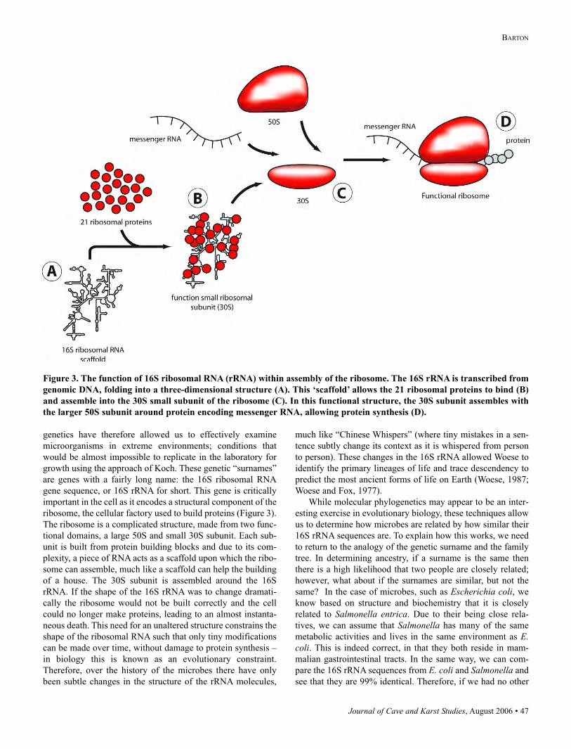
Figure 3. The function of 16S ribosomal RNA (rRNA) within assembly of the ribosome. The 16S rRNA is transcribed from
genomic DNA, folding into a three-dimensional structure (A). This ‘scaffold’ allows the 21 ribosomal proteins to bind (B)
and assemble into the 30S small subunit of the ribosome (C). In this functional structure, the 30S subunit assembles with
the larger 50S subunit around protein encoding messenger RNA, allowing protein synthesis (D).
48 • Journal of Cave and Karst Studies, August 2006
INTRODUCTION TO CAVE MICROBIOLOGY: A REVIEW FOR THE NON-SPECIALIST
information other than the 16S rRNA sequence, we can
hazard a guess that Salmonella had a similar metabolic
activity to E. coli. This is essentially the basis of the
molecular phylogenetic approach, allowing analysis of
microbial communities without cultivation. While the
technique seems pretty straightforward, in practice it’s
actually quite a challenge due to the complexity of
aligning thousands of DNA sequences to find the clos-
est match (Maidak et al., 2001; Maidak et al., 2000; Nei
et al., 1998). Nonetheless, how closely species are relat-
ed can be shown graphically as a dendrogram, which is
a mathematical model of a family tree based on a 16S
rRNA gene sequences (Figure 4). In scientific journals,
molecular phylogenetic analyses of environments are
often explained with dendrograms – with a scale at the
bottom to indicate the relative distance between organ-
isms. These dendrograms allow us to see how closely
organisms are related to the cultivated representatives
with known metabolic activity; the smaller the distance
the more closely an organism is related. These dendo-
grams also allow a visual representation of the structure
of the community; much like a yellow pages allows us
to determine what businesses drive the economy of a
city, dendograms allow us to determine what activities
drive the processes that support a microbial community
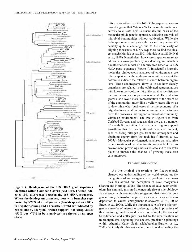
within an environment. The tree in Figure 4 is from
Carlsbad Caverns and suggests that there are a number
of metabolic activities that are occurring to support
growth in this extremely starved cave environment,
such as fixing nitrogen gas from the atmosphere and
obtaining energy from the rock itself (Barton et al.,2005a). Molecular phylogenetic analyses can also give
us information of what nutrients are available in an
environment, providing clues as what to add to our Petri
plates to improve the chances of growing those rare
cave microbes.
BROADER IMPLICATIONS
As the original observations by Leeuwenhoek
changed our understanding of the world around us, the
recognition of microorganisms in geologic cave sam-
ples has altered our perception of cave ecosystems
(Barton and Northup, 2006). The science of cave geomicrobi-
ology has similarly mirrored the meteoric rise of microbiology
as a science, with new insights suggesting that cave microor-
ganisms may be involved in processes as varied as speleothem
deposition to cavern enlargement (Canaveras et al., 2006;
Engel et al., 2004). While the important role of cave microor-
ganisms may be of interest to speleologists, the implications of
this research go well beyond caves. For example, the work of
Saiz-Jimenez and colleagues has led to the identification of
microorganisms degrading the ancient, prehistoric paintings
within Altamira Cave, Spain (Schabereiter-Gurtner et al.,2002). Not only did this work contribute to understanding the
Figure 4. Dendogram of the 16S rRNA gene sequences
identified within Carlsbad Cavern (NMT-sF). The bar indi-
cates 10% divergence between the 16S rRNA sequences.
Where the dendogram branches, those with branches sup-
ported by >70% of all alignments (bootstrap values >70%
in neighbor-joining and a heuristic search) are indicated by
closed circles. Marginal branch support (bootstrap values
>50% but >70% in both analyses) are shown by an open
circle.
Journal of Cave and Karst Studies, August 2006 • 49
BARTON
role of microorganisms in the degradation and subsequent con-
servation of these paintings, but it identified microbial species
that could colonize carbonate surfaces, depositing calcite.
Such work had significant implications in the preservation of
ancient marble monuments and statues, where microorganisms
could be used to deposit a veneer of calcite to protect ancient
structures from continued erosion (Laiz et al., 2003).
Similarly, within Carlsbad Caverns we have identified a novel
species of microorganism that can degrade complex aromatic
compounds, such as benzothiazole and benezenesulfonic acid
for growth, which are compounds involved in the manufacture
of plastics and are dangerous environmental contaminants
(Bennett and Barton, 2006). Such a capability could allow
these species to be inoculated into contaminated environments,
to rapidly degrade such pollutants and allow restoration of nat-
ural habitats in a process called bioremediation. Cave microor-
ganisms, with their adaptation to extreme starvation, also have
the potential to harbor other important biomolecules. Similar
environments have yielded microbes with properties that allow
efficient ethanol production for fuel, enzymes for environmen-
tally friendly paper processing and even the improved
stonewashing of jeans. Cave microorganisms also have the
potential to harbor unique antibiotics and cancer treatments
(Onaga, 2001). Finally, one of the philosophical questions of
humanity regards our place in the Universe: Are we alone? Is
life on Earth unique? Cave microbiology can not only answer
questions about the limits of life, but also help us to identify
the geochemical signatures of life. Such signatures are capable
of surviving geologic uplift, which allows them to be detected
on the surface of planets, such as Mars (Boston et al., 2001).
While such ideas may seem an extraordinary application of
cave geomicrobiology, NASA has recently undergone a dra-
matic refocus by gearing its activities to returning humans to
the moon and exploration of Mars and world’s beyond to find
evidence of past life, activities in which cave geomicrobiology
may play an important role (White House Press Release,
2004).
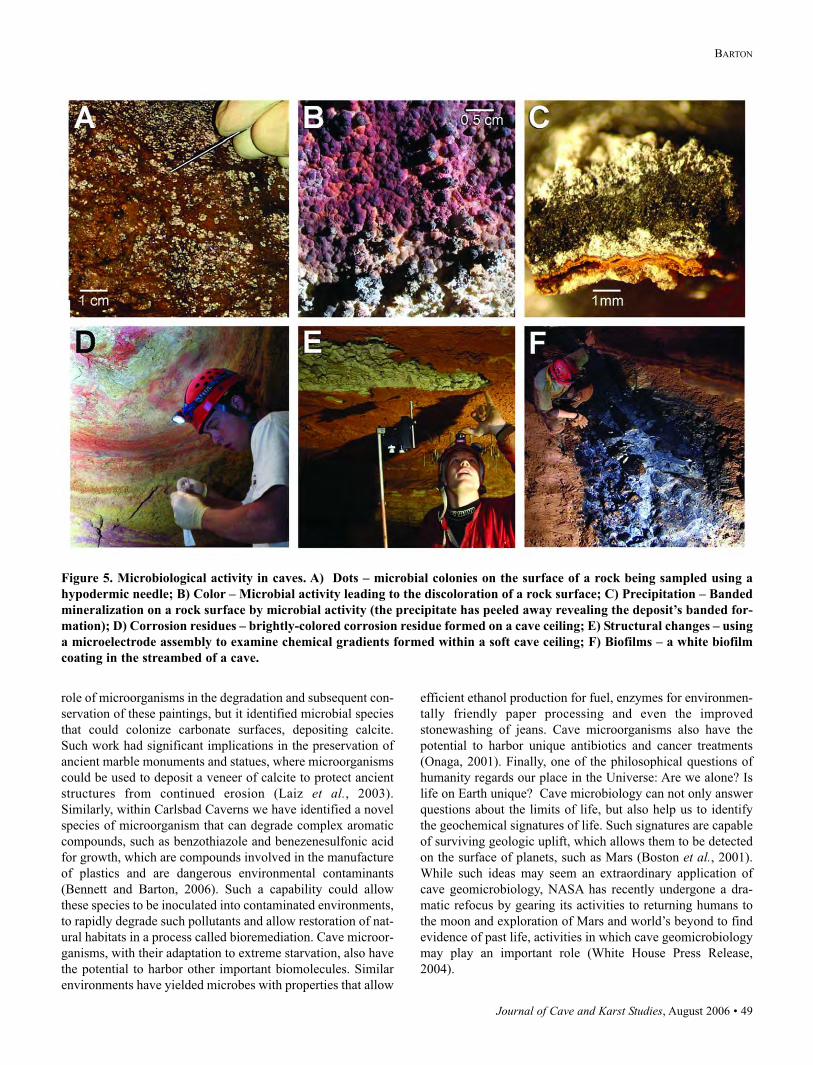
Figure 5. Microbiological activity in caves. A) Dots – microbial colonies on the surface of a rock being sampled using a
hypodermic needle; B) Color – Microbial activity leading to the discoloration of a rock surface; C) Precipitation – Banded
mineralization on a rock surface by microbial activity (the precipitate has peeled away revealing the deposit’s banded for-
mation); D) Corrosion residues – brightly-colored corrosion residue formed on a cave ceiling; E) Structural changes – using
a microelectrode assembly to examine chemical gradients formed within a soft cave ceiling; F) Biofilms – a white biofilm
coating in the streambed of a cave.
50 • Journal of Cave and Karst Studies, August 2006
INTRODUCTION TO CAVE MICROBIOLOGY: A REVIEW FOR THE NON-SPECIALIST
CAVE MICROBIOLOGY
While this extensive preamble has explained how difficult
cave microbiology can be and the technical solutions possible,
it does not preclude the average caver from being involved in
cave microbiology; however, it does hopefully explain why
running out and collecting “goo” in plastic bags is not going to
advance the field. In addition to the traditional leave-no-trace
conservation ethics of cave exploration, there are two signifi-
cant roles that cavers can play in cave microbiology; 1) is the
identification of new cave biota and ecosystems through con-
tinued exploration and survey, and 2) taking steps to limit
human contamination and conserving the microbial habitats of
caves.
CAVE SURVEYOR AS MICROBIOLOGIST
It may be a stretch to suggest that by exploring and sur-
veying a cave you are contributing to the field of cave geomi-
crobiology, but it remains almost impossible to predict the
location of microbial activity without its active discovery.
Microbial activity in caves range from the obvious slimy goop
to the more subtle deposition of calcite or alteration of the rock
surface. There are a number of features that can be identified
within caves as evidence of microbial activity (Figure 5):
Dots on surfaces: The appearance of dots on surfaces may
not necessarily be due to abiotic mineral deposition. Often,
where conditions are appropriate, microorganisms can grow up
as a colony large enough to be seen with the naked eye. These
colonies are similar in shape to those that might be seen on a
Petri plate and each represents the growth of millions of bac-
teria. Sometimes these colonies may be more apparent through
the concurrent deposition of minerals (such as calcite), creat-
ing a contrast against the host bedrock. Such microbial
colonies are particularly obvious in areas of seeping water.
Unusual coloration: When microorganisms grow on sur-
faces, they can alter the surface chemistry, leading to a subtle
change in coloration of the rock. Classic examples of this are
the black/red residues seen within the Lunch Room of
Carlsbad Caverns. The exact mechanism of this coloration
may vary from site to site with local chemistry and microbial
activity.
Precipitates: Microorganisms use chemical gradients to
generate energy, much as we use the chemical gradient
between food and oxygen to generate energy for life. In using
these gradients microorganisms may often change the sur-
rounding conditions of their environment, leading to a change
in the chemical properties of minerals. In the case of minerals
such as iron and manganese oxides, this will lead to a change
in the solubility of these minerals and lead to their precipita-
tion. Such microbially-mediated precipitation often forms
banded layers of minerals on surfaces.
Corrosion residues: A significant amount of work has been
carried out in caves of the Guadalupe Mountains on the corro-
sion residues that form as a result of microbial interactions
with the minerals of limestone and dolomite (Barton et al.,
2005a; Cunningham et al., 1995; Northup et al., 2003). While
researchers are still trying to elucidate the exact mechanism of
their formation, it appears that microbial metabolic activity is
involved in dissolving the host rock, while energy-generating
chemical gradients cause continued mineral transformation
and precipitation. Whatever the mechanism, these soft and
powdery corrosion residues are an exciting component of
geomicrobial activity in cave environments and may provide
useful insights to the mechanisms of energy generation in such
extremely starved environments.
Structural changes: When microorganisms interact with
the rock on which they live they can cause different chemical
changes in the rock. These changes may be distinct from the
bright color changes seen with corrosion residues, resulting in
subtle structural changes, such as decreased density or soften-
ing of the host rock. In Grayson-Gunnar Cave in Kentucky,
areas of the ceiling have been reduced to a wet, toothpaste-like
consistency that allows unique microbial energy acquisition
strategies.
Biofilms: One of the most obvious signs of microbiological
activity in a cave environment is the presence of biofilms.
These coatings are comprised of microbial communities, held
together with gel-like polymers that produce a range of struc-
tures including: wads of snot-like goo, floating dumplings,
slippery sub-aqueous coatings and hair-like tendrils. These
structures tend to form a sticky polymer that clumps bacterial
species together, with the environmental conditions and
mechanical action of water dictating the structure the commu-
nity will form. These biofilms often form where energy enters
the cave environment and have proven important insights into
the sources of energy supporting cave life (Angert et al.,1998).
A rule of thumb as a caver is that if you see anything
unusual that cannot be easily explained by geologic phenome-
na, it may be microbiological. There are a number of active
caver/microbiology researchers in the United States who can
help you determine its relative significance (Barton et al.,2005b; Boston et al., 2001; Chelius and Moore, 2004; Engel etal., 2004; Northup et al., 2003; Spear et al., 2005). In addition
to the identification of unique cave ecosystems, one of the
most important tools of our research is a cave line-plot/survey
and map. Such maps allow researchers to determine how far
below the surface the microbial activity is found, its relative
position to geologic faults and other factors that might bring
energy in to the system for microbial growth.
MICROBIAL CONSERVATION
While it can be difficult to remember to protect things that
you cannot see, to minimize your impact on microbes, mini-
mum impact caving techniques are appropriate. These include
keeping to the established trail, removing all waste, avoid
touching anything unnecessarily and generally minimizing
your impact on the environment. While we often caution
novices against touching formations, it is important to think
similarly about placing limits on unnecessarily touching walls
Journal of Cave and Karst Studies, August 2006 • 51
BARTON
(particularly where moisture is obvious), undisturbed sedi-
ments and corrosion residues. Some cave systems can with-
stand more human impact than others, and the same is true for
microbial systems. If a cave floods, it is likely that the
microbes are adapted to sudden influxes of material and ener-
gy, so a level of anxiety is not called for and less care need be
taken. Other systems with perennially dry passages are more
easily impacted. In some extreme instances, such as
Lechuguilla Cave, flagged trails limit all travelers to the same
area, to avoid walls and other surfaces unnecessarily.
In addition to conservation activities within the cave, also
think about activities that you are carrying out in preparing for
the cave. The biggest impact people can have on microbial
ecosystems in caves is not washing caving gear and seeding
one cave with another cave’s microbes. I’ve heard of some
cavers who will go down and smell their coveralls between
caving trips, to get their cave fix from that earthy-smell of the
dirt in their coveralls. That smell is a mixture of organic prod-
ucts being produced when microbial species, known as
Actinomycetes, decompose organic material (Jachymova et al.,2002; Scholler et al., 2002). While you may get your kicks
from smelling microbial excrement, it also means that if
unwashed, those Actinomycetes will be traveling in to the next
cave system with you.
In limiting your impact on such environments think about
the potentially delicate nature of microbial ecosystems and,
while I wouldn’t recommend bathing in disinfectant (showers
are counter productive as it dries skin out, increasing skin cell
shedding) or wearing environmental suits, common sense
should prevail. Think about your personal hygiene when enter-
ing a delicate cave system: Have you brushed your hair recent-
ly? Is long hair tied back so it won’t be shedding in the cave?
Think about the food you take with you into a cave. Avoid any-
thing that generates crumbs and try to eat over a plastic bag,
even when there is little chance of spilling, because one crumb
is enough to feed a million microbes for many months. In addi-
tion to following leave-no-trace ethics to maintain the aesthet-
ic beauty and visible ecosystems of the cave environment, sim-
ilar care can go a long way to conserving microbial ecosystem
health.
CONCLUSION
The science of geomicrobiology is still in its infancy, and
as with other fields within microbiology, it is continuing to
evolve. As it does, significant discoveries are updating our
understanding of microbe-rock interactions and how microor-
ganisms have helped shape our global environment (Balkwill
et al., 1997; Banfield and Nealson, 1997; Barghoorn and
Schopf, 1966; Ben-Ari, 2002; Colwell et al., 1997; Schopf,
1983). Similarly, cave microbiology is continually changing;
from the preliminary description of cave microbiota at the turn
of the last century to the sophisticated techniques employed
today (Caumartin, 1963; Sarbu et al., 1996). As cavers contin-
ue to explore caves in search of the unknown, they can help
geomicrobiologists identify unique microbial ecosystems and
help us to preserve this important resource.
ACKNOWLEDGEMENTS
The author would like to thank the many geologists and
microbiologists who have provided expert guidance and con-
sultation over the years, in particular: Janet L. Bertog, Kirk
Harris, Brian K. Kinkle, Fred Luiszer, Diana E. Northup,
Norman R. Pace, John R. Roth and John R. Spear. I would also
like to thank Brad R. Lubbers for excellent technical assis-
tance, Karl Hagglund for electron microscopy, my research
students, Adin Pemberton, Ariel L. Bennett and Nicholas M.
Taylor, and the numerous cavers who have provided invaluable
assistance in examining cave microbiota, in particular: Paul
Burger, Jason Gulley and Eric Weaver.
REFERENCES
Amann, R.I., Ludwig, W., and Schleifer, K.H., 1995,
Phylogenetic identification and in situ detection of individ-
ual microbial cells without cultivation: Microbiological
Reviews, v. 59, p. 143–169.
Amann, R.I., Snaidr, J., Wagner, M., Ludwig, W., and
Schleifer, K.H., 1996, In situ visualization of high genetic
diversity in a natural community: Journal Bacteriology, v.
178, p. 3496–3500.
Angert, E.R., Northup, D.E., Reysenbach, A.-L., Peek, A.S.,
Goebel, B.M., and Pace, N.R., 1998, Molecular phyloge-
netic analysis of a bacterial community in Sulphur River,
Parker Cave, Kentucky: American Mineralogist., v. 83, p.
1583–1592.
Balkwill, D.L., Drake, G.R., Reeves, R.H., Fredrickson, J.K.,
White, D.C., Ringelberg, D.B., Chandler, D.P., Romine,
M.F., Kennedy, D.W., and Spadoni, C.M., 1997,
Taxanomic study of aromatic-degrading Bacteria from
deep-terrestrial-subsurface sediments and description of
Sphingomonas aromaticivorans sp. nov., Sphingomonassubterranea sp. nov., and Sphingomonas stygia sp. nov:
International Journal of Systematic Bacteriology, v. 47, p.
191–201.
Banfield, J.F., and Nealson, K.H., eds., 1997,
Geomicrobiology: Interactions between microbes and min-
erals: Reviews in Mineralogy, v. 35: Washington, D.C.,
Mineralogical Society of American, 448 p.
Barghoorn, E.S., and Schopf, J.W., 1966, Microorganisms
three billion years old from the Precambrian of South
Africa: Science, v. 152, p. 758–763.
Barton, H.A. and Luiszer, F., 2005, Microbial Metabolic
Structure in a Sulfidic Cave Hot Spring: Potential
Mechanisms of Biospeleogenesis: Journal of Cave and
Karst Studies, v. 67, p. 28–38.
Barton, H.A. and Northup, D.E., 2006, Geomicrobiology in
cave environments: Past, current and future perspectives:
Journal of Cave and Karst Studies, submitted.
52 • Journal of Cave and Karst Studies, August 2006
INTRODUCTION TO CAVE MICROBIOLOGY: A REVIEW FOR THE NON-SPECIALIST
Barton, H.A., Taylor, M.R., and Pace, N.R., 2004, Molecular
phylogenetic analysis of a bacterial community in an olig-
otrophic cave environment: Geomicrobiology Journal, v.
21, p. 11–20.
Barton, H.A., Taylor, N.M., Kreate, M., Bertog, J., and Oehrle,
S., 2005a, The impact of organic load on geomicrobial
transformation in oligotrophic cave environments: Applied
and Environmental Microbiology, submitted.
Barton, H.A., Taylor, N.M., Lubbers, B.R., and Pemberton,
A.C., 2005b, DNA extraction from low biomass carbonate
rock: an improved method with reduced contamination and
the Low-Biomass Contaminant (LBC) database: Journal of
Microbiological Methods, in press.
Ben-Ari, E.T., 2002, Microbiology and Geology: Solid mar-
riage made on Earth: ASM News, v. 68, p. 13–18.
Bennett, A., and Barton, H.A., 2006, Description of
Polaromonas subterraneae sp. nov., a new representative
of the genus Polaromonas identified within oligotrophic
cave and Karst environments: International Journal of
Systematic and Evolutionary Microbiology, v., in prepara-
tion.
Bloomfield, S.F., Stewart, G.S., Dodd, C.E.R., Booth, I.R., and
Power, E.G.M., 1998, The viable but non-culturable phe-
nomenon explained?: Microbiology, v. 144, p. 1–3.
Bogosian, G., Aardema, N.D., Bourneuf, E.V., Morris, P.J.L.,
and O’Neil, J.P., 2000, Recovery of hydrogen peroxide-
sensitive culturable cells of Vibrio vulnificus gives the
appearance of resuscitation from a viable but nonculturable
state: Journal of Bacteriology, v. 182, p. 5070–5075.
Bond, P.L., Smriga, S.P., and Banfield, J.F., 2000, Phylogeny
of microorganisms populating a thick, subaerial, predomi-
nantly lithotrophic biofilm at an extreme acid mine
drainage site: Applied and Environmental Microbiology, v.
66, p. 3842–3849.
Boston, P.J., Spilde, M.N., Northup, D.E., Melim, L.A.,
Soroka, D.S., Kleina, L.G., Lavoie, K.H., Hose, L.D.,
Mallory, L.M., Dahm, C.N., Crossey, L.J., and Schelble,
R.T., 2001, Cave Biosignature Suite: Microbes, Minerals
and Mars: Astrobiology, v. 1, p. 25–55.
Brock, T.D., 1967, Micro-organisms adapted to high tempera-
tures: Nature, v. 214, p. 882–885.
Canaveras, J.C., Cuezva, S., Sanchez-Moral, S., Lario, J., Laiz,
L., Gonzalez, J.M., and Saiz-Jimenez, C., 2006, On the ori-
gin of fiber calcite crystals in moonmilk deposits:
Naturwissenschaften, v. 93, p. 27–32.
Canaveras, J.C., Sanchez-Moral, S., Soler, V., and Saiz-
Jimenez, C., 2001, Microorganisms and microbially
induced fabrics in cave walls: Geomicrobiology Journal, v.
18, p. 223–240.
Caumartin, V., 1963, Review of the microbiology of under-
ground environments: National Speleological Society
Bulletin, v. 25, p. 1–14.
Chelius, M.K., and Moore, J.C., 2004, Molecular phylogenet-
ic analysis of Archaea and Bacteria in Wind Cave, South
Dakota: Geomicrobiology Journal, v. 21, p. 123–134.
Colwell, F.S., Onstott, T.C., Delwiche, M.E., Chandler, D.,
Fredrickson, J.K., Yao, Q.-J., McKinley, J.P., Boone, D.R.,
Griffiths, R., Phelps, T.J., Ringelberg, D., White, D.C.,
LaFreniere, L., Balkwill, D., Lehman, R.M., Konisky, J.,
and Long, P.E., 1997, Microorganisms from deep, high
temperature sandstones: Constraints of microbial coloniza-
tion: FEMS Microbiology Reviews, v. 20, p. 425–435.
Cunningham, K.I., Northup, D.E., Pollastro, R.M., Wright,
W.G., and LaRock, E.J., 1995, Bacteria, fungi and biokarst
in Lechuguilla Cave, Carlsbad Caverns National Park,
New Mexico: Environmental Geology, v. 25, p. 2–8.
Curtis, T.P., Sloan, W.T., and Scannell, J.W., 2002, Estimating
prokaryotic diversity and its limits: Proceedings of the
National Academy of Science USA, v. 99, p. 10494–10499.
Dojka, M.A., Harris, J.K., and Pace, N.R., 2000, Expanding
the known diversity and environmental distribution of an
uncultivated phylogenetic division of bacteria: Applied and
Environmental Microbiology, v. 66, p. 1617–1621.
Engel, A.S., Stern, L.A., and Bennett, A., 2003, Condensation
on cave walls: Implications for cave enlargement and sul-
furic acid speleogenesis: Geochemica et Cosmochimica
Acta, v. 67, p. A455.
Engel, A.S., Stern, L.A., and Bennett, P.C., 2004, Microbial
contributions to cave formation: New insights into sulfuric
acid speleogenesis: Geology, v. 32, p. 369–372.
Gold, T., 1999, The Deep Hot Biosphere: New York, Springer-
Verlag, 235 p.
Gonzalez, J.M., Portillo, M.C., and Saiz-Jimenez, C., 2006,
Metabolically active Crenarchaeota in Altamira Cave:
Naturwissenschaften, v. 93, p. 42–45.
Groth, I., and Saiz-Jimenez, C., 1999, Actinomycetes in
hypogean environments: Geomicrobiology Journal, v. 16,
p. 1–8.
Groth, I., Vettermann, R., Schuetze, B., Schumann, P., and
Saiz-Jimenez, C., 1999, Actinomycetes in karstic caves of
Northern Spain (Altamira and Tito Bustillo). Journal of
Microbiological Methods, v. 36, p. 115–122.
Holmes, A.J., Tujula, N.A., Holley, M., Contos, A., James,
J.M., Rogers, P., and Gillings, M.R., 2001, Phylogenetic
structure of unusual aquatic microbial formations in
Nullarbor Caves, Australia: Environmental Microbiology,
v. 3, p. 256–264.
Hose, L.D., Palmer, A.N., Palmer, M.V., Northup, D.E.,
Boston, P.J., and DuChene, H.R., 2000, Microbiology and
geochemistry in a hydrogen-sulfide-rich karst environ-
ment: Chemical Geology, v. 169, p. 399–423.
Hugenholtz, P., Goebel, B.M., and Pace, N.R., 1998, Impact of
culture-independent studies on the emerging phylogenetic
view of Bacterial diversity: Journal of Bacteriology, v. 180,
p. 4765–4774.
Jachymova, J., Votruba, J., Viden, I., and Rezanka, T., 2002,
Identification of Streptomyces odor spectrum: Folia
Microbiology (Praha), v. 47, p. 37–41.
Jannasch, H.W., Wirsen, C.O., Molyneaux, S.J., and
Langworthy, T.A., 1992, Comparative physiological stud-
Journal of Cave and Karst Studies, August 2006 • 53
BARTON
ies on hyperthermophilic archaea isolated from deep-sea
hot vents with emphasis on Pyrococcus strain GB-D:
Applied and Environmental Microbiology, v. 58, p.
3472–3481.
Koch, A.L., 1997, Microbial physiology and ecology of slow
growth: Microbiology and Molecular Biology Reviews, v.
61, p. 305–318.
Koch, A.L., 2001, Oligotrophs versus copiotrophs: BioEssays,
v. 23, p. 657–661.
Koch, R., 1881, Zur Untersuchung von pathogenen
Organismen: Mitth. a. d. Kaiserl. Gesundheitsampte 1:
1–48. In Milestones in Microbiology: 1556 to 1940, trans-
lated and edited by Thomas D. Brock, ASM Press. 1998, p.
101.
Laiz, L., Groth, I., Gonzalez, I., and Saiz-Jimenez, C., 1999,
Microbiological study of the dripping water in Altamira
Cave (Santillana del Mar, Spain): Journal of
Microbiological Methods, v. 36, p. 129–138.
Laiz, L., Pinar, G., Lubitz, W., and Saiz-Jimenez, C., 2003,
Monitoring the colonization of monuments by bacteria:
Cultivation versus molecular methods: Environmental
Microbiology, v. 5, p. 72–74.
Lane, D.J., Pace, B., Olsen, G.J., Stahl, D.A., Sogin, M.L., and
Pace, N.R., 1985, Rapid determination of 16S ribosomal
RNA sequences for phylogenetic analyses: Proceedings of
the National Academy of Sciences USA, v. 82, p.
6955–6959.
Madigan, M.T., Matinko, J.M., and Parker, J., 2000, Brock:
Biology of Microorganisms: Upper Saddle River, N. J.,
Prentice-Hall Inc.
Maidak, B.L., Cole, J.R., Lilburn, T.G., Parker, J., Saxman,
P.R., Farris, R.J., Garrity, G.M., Olsen, G.J., Schmidt, T.M.,
and Tiedje, J.M., 2001, The RDP-II (Ribosome Database
Project): Nucleic Acids Research, v. 29, p. 173–174.
Maidak, B.L., Cole, J.R., Lilburn, T.G., Parker, C.T., Saxman,
P.R., Stredwick, J.M., Garrity, G.M., Li, B., Olsen, G.J.,
Schmidt, T.M., and Tiedje, J.M., 2000, The RDP
(Ribosomal Database Project) continues: Nucleic Acids
Research, v. 28, p. 173–174.
May, R.M., 1988, How many species are there on Earth?:
Science, v. 241, p. 1441–1449.
Mormile, M.R., Biesen, M.A., Gutierrez, M.C., Ventosa, A.,
Pavlovich, J.B., Onstott, T.C., and Fredrickson, J.K., 2003,
Isolation of Halobacterium salinarum retrieved directly
from halite brine inclusions: Environmental Microbiology,
v. 5, p. 1094–1102.
Nei, M., Kumar, S., and Takahashi, K., 1998, The optimization
principle in phylogenetic analysis tends to give incorrect
topologies when the number of nucleotide or amino acids
used is small: Proceedings of the National Academy of
Sciences USA, v. 95, p. 12390–12397.
Northup, D.E., Barnes, S.M., Yu, L.E., Spilde, M.N., Schelble,
R.T., Dano, K.E., Crossey, L.J., Connolly, C.A., Boston,
P.J., Natvig, D.O., and Dahm, C.N., 2003, Diverse micro-
bial communities inhabiting ferromanganese deposits in
Lechuguilla and Spider Caves: Environmental
Microbiology, v. 5, p. 1071-1086.
Northup, D.E., and Lavoie, K.H., 2001, Geomicrobiology of
Caves: A Review: Geomicrobiology Journal, v. 18, p.
199–222.
Oliver, J.D., 1995, The viable but non-culturable state in the
human pathogen Vibrio vulnificus: FEMS Microbiology
Letters, v. 133, p. 203–208.
Onaga, L., 2001, Cashing in on nature’s pharmacy: EMBO
Reports, v. 2, p. 263–265.
Pace, N.R., 1997, A molecular view of microbial diversity and
the biosphere: Science, v. 276.
Pemberton, A., Millette, J., and Barton, H.A., 2005,
Comparative Study Of Oligotrophic Bacterial Species
Cultivated From Jack Bradley Cave, Kentucky: 14th
International Congress of Speleology.
Sarbu, S.M., Kane, T.C., and Kinkle, B.K., 1996, A chemoau-
totrophically based cave ecosystem: Science, v. 272, p.
1953–1955.
Schabereiter-Gurtner, C., Saiz-Jimenez, C., Pinar, G., Lubitz,
W., and Rolleke, S., 2002, Cave paleolithic paintings har-
bour complex and partly unknown microbial communities:
FEMS Microbiology Letters, v. 211, p. 7–11.
Scholler, C.E., Gurtler, H., Pedersen, R., Molin, S., and
Wilkins, K., 2002, Volatile metabolites from
Actinomycetes: Journal of Agricultural Food Chemistry, v.
50, p. 2615–2621.
Schopf, J.W., ed., 1983, Earth’s earliest biosphere: its origin
and evolution: Princeton, N.J., Princeton University Press,
531 p.
Shivaji, S., Reddy, G.S., Raghavan, P.U., Sarita, N.B., and
Delille, D., 2004, Psychrobacter salsus sp. nov. and
Psychrobacter adeliensis sp. nov. isolated from fast ice
from Adelie Land, Antarctica: Systematic and Applied
Microbiology, v. 27, p. 628–635.
Spear, J.R., Walker, G.C., McCollom, T.M., and Pace, N.R.,
2005, Hydrogen and bioenergetics in a Yellowstone geot-
hermal ecosystem: Proceedings of the National Academy
of Sciences USA, v. 102, p. 2555–2560.
Spilde, M.N., Northup, D.E., Boston, P.J., Schelble, R.T.,
Dano, K.E., Crossey, L.J., and Dahm, C.N., 2005,
Geomicrobiology of cave ferromanganese deposits: A field
and laboratory investigation: Geomicrobiology Journal, v.
22, p. 99–116.
Stahl, D.A., Lane, D.J., Olsen, G.J., and Pace, N.R., 1985,
Characterization of a Yellowstone hot spring microbial
community by 5S rRNA sequences: Applied and
Environmental Microbiology, v. 49, p. 1379–1384.
Thomas, D.N., and Dieckmann, G.S., 2002, Antarctic sea ice -
a habitat for extremophiles: Science, v. 295, p. 641–644.
Torsvik, V., Ovreas, L., and Thingstad, T.F., 2002, Prokaryotic
diversity - magnitude, dynamics, and controlling factors:
Science, v. 296, p. 1064–1066.

54 • Journal of Cave and Karst Studies, August 2006
INTRODUCTION TO CAVE MICROBIOLOGY: A REVIEW FOR THE NON-SPECIALIST
White House Press Release, 2004, President Bush Announces
New Vision for Space Exploration Program, Washington,
D.C., Office of the White House Press Secretary, p. 1–3.
Whitesides, M.D., and Oliver, J.D., 1997, Resuscitation of
Vibrio vulnificus from the viable but nonculturable state:
Applied and Environmental Microbiology, v. 63, p.
1002–1005.
Whittaker, R.H., 1969, New concepts of kingdoms of organ-
isms. Evolutionary relations are better represented by new
classications than by the traditional two kingdoms:
Science, v. 163, p. 150–160.
Winogradsky, S., 1887, Uber Schwefelbacterien: Botanische
Zeitung, v. 40.
Woese, C.R., 1987, Bacterial evolution: Microbiological
Reviews, v. 51, p. 221–271.
Woese, C.R., and Fox, G.E., 1977, Phylogenetic structure of
the prokaryotic domain: the primary kingdoms:
Proceedings National Academy Sciences, v. 74, p.
5088–5090.
Journal of Cave and Karst Studies, August 2006 • 55
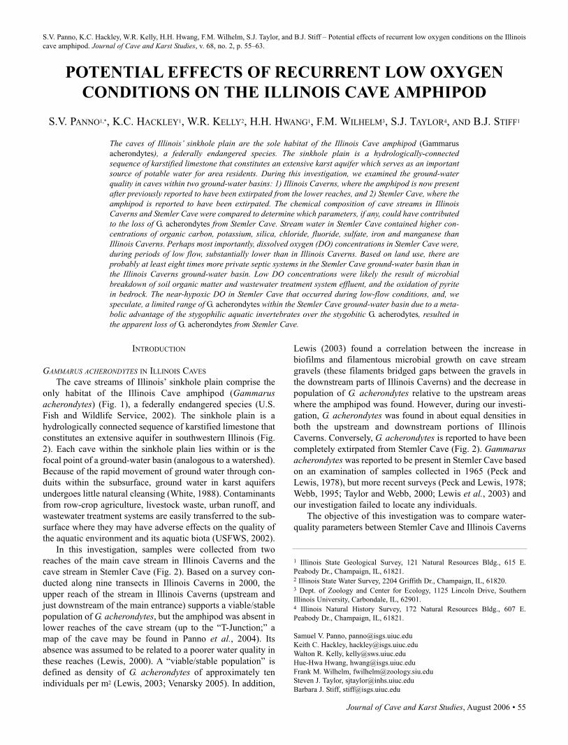
S.V. Panno, K.C. Hackley, W.R. Kelly, H.H. Hwang, F.M. Wilhelm, S.J. Taylor, and B.J. Stiff – Potential effects of recurrent low oxygen conditions on the Illinois
cave amphipod. Journal of Cave and Karst Studies, v. 68, no. 2, p. 55–63.
INTRODUCTION
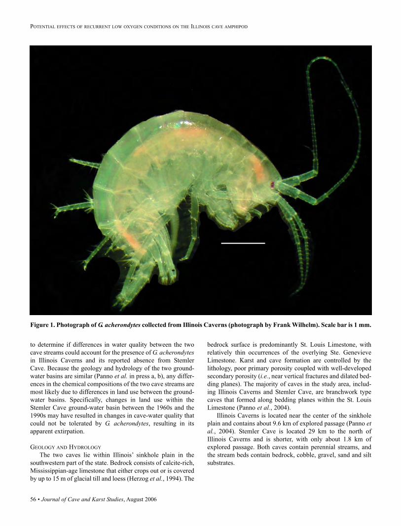
GAMMARUS ACHERONDYTES IN ILLINOIS CAVES
The cave streams of Illinois’ sinkhole plain comprise the
only habitat of the Illinois Cave amphipod (Gammarusacherondytes) (Fig. 1), a federally endangered species (U.S.
Fish and Wildlife Service, 2002). The sinkhole plain is a
hydrologically connected sequence of karstified limestone that
constitutes an extensive aquifer in southwestern Illinois (Fig.
2). Each cave within the sinkhole plain lies within or is the
focal point of a ground-water basin (analogous to a watershed).
Because of the rapid movement of ground water through con-
duits within the subsurface, ground water in karst aquifers
undergoes little natural cleansing (White, 1988). Contaminants
from row-crop agriculture, livestock waste, urban runoff, and
wastewater treatment systems are easily transferred to the sub-
surface where they may have adverse effects on the quality of
the aquatic environment and its aquatic biota (USFWS, 2002).
In this investigation, samples were collected from two
reaches of the main cave stream in Illinois Caverns and the
cave stream in Stemler Cave (Fig. 2). Based on a survey con-
ducted along nine transects in Illinois Caverns in 2000, the
upper reach of the stream in Illinois Caverns (upstream and
just downstream of the main entrance) supports a viable/stable
population of G. acherondytes, but the amphipod was absent in
lower reaches of the cave stream (up to the “T-Junction;” a
map of the cave may be found in Panno et al., 2004). Its
absence was assumed to be related to a poorer water quality in
these reaches (Lewis, 2000). A “viable/stable population” is
defined as density of G. acherondytes of approximately ten
individuals per m2 (Lewis, 2003; Venarsky 2005). In addition,
Lewis (2003) found a correlation between the increase in
biofilms and filamentous microbial growth on cave stream
gravels (these filaments bridged gaps between the gravels in
the downstream parts of Illinois Caverns) and the decrease in
population of G. acherondytes relative to the upstream areas
where the amphipod was found. However, during our investi-
gation, G. acherondytes was found in about equal densities in
both the upstream and downstream portions of Illinois
Caverns. Conversely, G. acherondytes is reported to have been
completely extirpated from Stemler Cave (Fig. 2). Gammarusacherondytes was reported to be present in Stemler Cave based
on an examination of samples collected in 1965 (Peck and
Lewis, 1978), but more recent surveys (Peck and Lewis, 1978;
Webb, 1995; Taylor and Webb, 2000; Lewis et al., 2003) and
our investigation failed to locate any individuals.
The objective of this investigation was to compare water-
quality parameters between Stemler Cave and Illinois Caverns
POTENTIAL EFFECTS OF RECURRENT LOW OXYGEN
CONDITIONS ON THE ILLINOIS CAVE AMPHIPOD
S.V. PANNO1,*, K.C. HACKLEY1, W.R. KELLY2, H.H. HWANG1, F.M. WILHELM3, S.J. TAYLOR4, AND B.J. STIFF1
The caves of Illinois’ sinkhole plain are the sole habitat of the Illinois Cave amphipod (Gammarus
acherondytes), a federally endangered species. The sinkhole plain is a hydrologically-connectedsequence of karstified limestone that constitutes an extensive karst aquifer which serves as an importantsource of potable water for area residents. During this investigation, we examined the ground-waterquality in caves within two ground-water basins: 1) Illinois Caverns, where the amphipod is now presentafter previously reported to have been extirpated from the lower reaches, and 2) Stemler Cave, where theamphipod is reported to have been extirpated. The chemical composition of cave streams in IllinoisCaverns and Stemler Cave were compared to determine which parameters, if any, could have contributedto the loss of G. acherondytes from Stemler Cave. Stream water in Stemler Cave contained higher con-centrations of organic carbon, potassium, silica, chloride, fluoride, sulfate, iron and manganese thanIllinois Caverns. Perhaps most importantly, dissolved oxygen (DO) concentrations in Stemler Cave were,during periods of low flow, substantially lower than in Illinois Caverns. Based on land use, there areprobably at least eight times more private septic systems in the Stemler Cave ground-water basin than inthe Illinois Caverns ground-water basin. Low DO concentrations were likely the result of microbialbreakdown of soil organic matter and wastewater treatment system effluent, and the oxidation of pyritein bedrock. The near-hypoxic DO in Stemler Cave that occurred during low-flow conditions, and, wespeculate, a limited range of G. acherondytes within the Stemler Cave ground-water basin due to a meta-bolic advantage of the stygophilic aquatic invertebrates over the stygobitic G. acherodytes, resulted inthe apparent loss of G. acherondytes from Stemler Cave.
1 Illinois State Geological Survey, 121 Natural Resources Bldg., 615 E.
Peabody Dr., Champaign, IL, 61821.2 Illinois State Water Survey, 2204 Griffith Dr., Champaign, IL, 61820. 3 Dept. of Zoology and Center for Ecology, 1125 Lincoln Drive, Southern
Illinois University, Carbondale, IL, 62901.4 Illinois Natural History Survey, 172 Natural Resources Bldg., 607 E.
Peabody Dr., Champaign, IL, 61821.
Samuel V. Panno, [email protected]
Keith C. Hackley, [email protected]
Walton R. Kelly, [email protected]
Hue-Hwa Hwang, [email protected]
Frank M. Wilhelm, [email protected]
Steven J. Taylor, [email protected]
Barbara J. Stiff, [email protected]
56 • Journal of Cave and Karst Studies, August 2006
POTENTIAL EFFECTS OF RECURRENT LOW OXYGEN CONDITIONS ON THE ILLINOIS CAVE AMPHIPOD
to determine if differences in water quality between the two
cave streams could account for the presence of G. acherondytesin Illinois Caverns and its reported absence from Stemler
Cave. Because the geology and hydrology of the two ground-
water basins are similar (Panno et al. in press a, b), any differ-
ences in the chemical compositions of the two cave streams are
most likely due to differences in land use between the ground-
water basins. Specifically, changes in land use within the
Stemler Cave ground-water basin between the 1960s and the
1990s may have resulted in changes in cave-water quality that
could not be tolerated by G. acherondytes, resulting in its
apparent extirpation.
GEOLOGY AND HYDROLOGY
The two caves lie within Illinois’ sinkhole plain in the
southwestern part of the state. Bedrock consists of calcite-rich,
Mississippian-age limestone that either crops out or is covered
by up to 15 m of glacial till and loess (Herzog et al., 1994). The
bedrock surface is predominantly St. Louis Limestone, with
relatively thin occurrences of the overlying Ste. Genevieve
Limestone. Karst and cave formation are controlled by the
lithology, poor primary porosity coupled with well-developed
secondary porosity (i.e., near vertical fractures and dilated bed-
ding planes). The majority of caves in the study area, includ-
ing Illinois Caverns and Stemler Cave, are branchwork type
caves that formed along bedding planes within the St. Louis
Limestone (Panno et al., 2004).
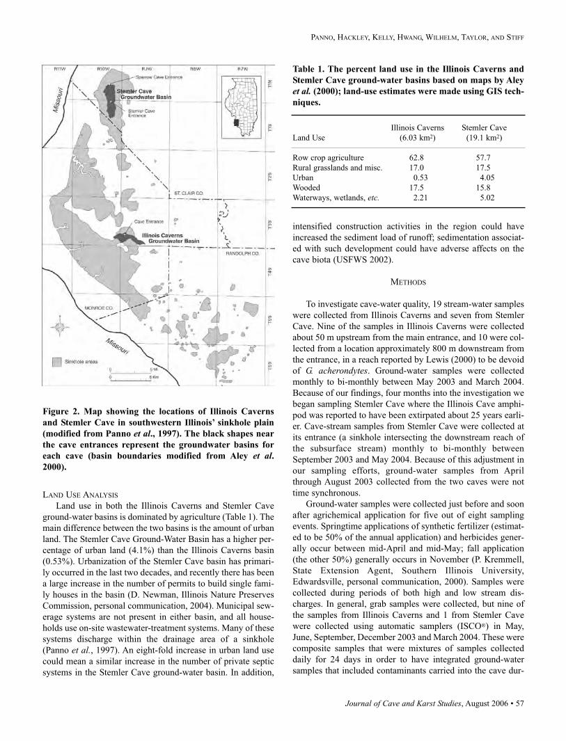
Illinois Caverns is located near the center of the sinkhole
plain and contains about 9.6 km of explored passage (Panno etal., 2004). Stemler Cave is located 29 km to the north of
Illinois Caverns and is shorter, with only about 1.8 km of
explored passage. Both caves contain perennial streams, and
the stream beds contain bedrock, cobble, gravel, sand and silt
substrates.
Figure 1. Photograph of G. acherondytes collected from Illinois Caverns (photograph by Frank Wilhelm). Scale bar is 1 mm.
Journal of Cave and Karst Studies, August 2006 • 57
PANNO, HACKLEY, KELLY, HWANG, WILHELM, TAYLOR, AND STIFF
Figure 2. Map showing the locations of Illinois Caverns
and Stemler Cave in southwestern Illinois’ sinkhole plain
(modified from Panno et al., 1997). The black shapes near
the cave entrances represent the groundwater basins for
each cave (basin boundaries modified from Aley et al.2000).
LAND USE ANALYSIS
Land use in both the Illinois Caverns and Stemler Cave
ground-water basins is dominated by agriculture (Table 1). The
main difference between the two basins is the amount of urban
land. The Stemler Cave Ground-Water Basin has a higher per-
centage of urban land (4.1%) than the Illinois Caverns basin
(0.53%). Urbanization of the Stemler Cave basin has primari-
ly occurred in the last two decades, and recently there has been
a large increase in the number of permits to build single fami-
ly houses in the basin (D. Newman, Illinois Nature Preserves
Commission, personal communication, 2004). Municipal sew-
erage systems are not present in either basin, and all house-
holds use on-site wastewater-treatment systems. Many of these
systems discharge within the drainage area of a sinkhole
(Panno et al., 1997). An eight-fold increase in urban land use
could mean a similar increase in the number of private septic
systems in the Stemler Cave ground-water basin. In addition,
intensified construction activities in the region could have
increased the sediment load of runoff; sedimentation associat-
ed with such development could have adverse affects on the
cave biota (USFWS 2002).
METHODS
To investigate cave-water quality, 19 stream-water samples
were collected from Illinois Caverns and seven from Stemler
Cave. Nine of the samples in Illinois Caverns were collected
about 50 m upstream from the main entrance, and 10 were col-
lected from a location approximately 800 m downstream from
the entrance, in a reach reported by Lewis (2000) to be devoid
of G. acherondytes. Ground-water samples were collected
monthly to bi-monthly between May 2003 and March 2004.
Because of our findings, four months into the investigation we
began sampling Stemler Cave where the Illinois Cave amphi-
pod was reported to have been extirpated about 25 years earli-
er. Cave-stream samples from Stemler Cave were collected at
its entrance (a sinkhole intersecting the downstream reach of
the subsurface stream) monthly to bi-monthly between
September 2003 and May 2004. Because of this adjustment in
our sampling efforts, ground-water samples from April
through August 2003 collected from the two caves were not
time synchronous.
Ground-water samples were collected just before and soon
after agrichemical application for five out of eight sampling
events. Springtime applications of synthetic fertilizer (estimat-
ed to be 50% of the annual application) and herbicides gener-
ally occur between mid-April and mid-May; fall application
(the other 50%) generally occurs in November (P. Kremmell,
State Extension Agent, Southern Illinois University,
Edwardsville, personal communication, 2000). Samples were
collected during periods of both high and low stream dis-
charges. In general, grab samples were collected, but nine of
the samples from Illinois Caverns and 1 from Stemler Cave
were collected using automatic samplers (ISCO®) in May,
June, September, December 2003 and March 2004. These were
composite samples that were mixtures of samples collected
daily for 24 days in order to have integrated ground-water
samples that included contaminants carried into the cave dur-
Table 1. The percent land use in the Illinois Caverns and
Stemler Cave ground-water basins based on maps by Aley
et al. (2000); land-use estimates were made using GIS tech-
niques.
Illinois Caverns Stemler Cave
Land Use (6.03 km2) (19.1 km2)
Row crop agriculture 62.8 57.7
Rural grasslands and misc. 17.0 17.5
Urban 0.53 4.05
Wooded 17.5 15.8
Waterways, wetlands, etc. 2.21 5.02
58 • Journal of Cave and Karst Studies, August 2006
POTENTIAL EFFECTS OF RECURRENT LOW OXYGEN CONDITIONS ON THE ILLINOIS CAVE AMPHIPOD
ing and following large rainfall events. Some of the water sam-
pling events were coordinated with timed area searches and
bait trapping of invertebrates at the same ground-water sam-
pling locations in both caves. However, the tasks were sepa-
rated by several days so that sediments suspended by inverte-
brate counts did not affect subsequent water sampling.
Invertebrates were counted at Illinois Caverns on two occa-
sions; one event was conducted during high-flow conditions
(May 2003) and the other at low flow (September 2003).
Invertebrates were counted in Stemler Cave on one occasion
under high-flow conditions (May 2004). An inspection of
Sparrow Creek Cave, the distal end of the Stemler Cave
ground-water basin, was conducted in March 2004. Because of
the relatively deep water in this part of the cave, a dip net and
aquarium net were used to examine sediment whenever possi-
ble. When found, all adult amphipods were field identified
with the aid of a dissecting microscope, counted, and released.
Temperature, pH, Eh, dissolved oxygen (DO) and specific
conductance (SpC) were measured using standard field tech-
niques and meters with temperature compensation. Stream dis-
charge was measured using a stream velocity gage along mea-
sured cross sections of the cave streams in non-turbulent
stream segments (e.g., Panno et al., 2003). All water samples
were analyzed for major cations and anions; ammonium-nitro-
gen (NH4-N); total Kjeldhal nitrogen (TKN); herbicides used
on fields in the study area including atrazine, bentazon, chlo-
rimuron, cyanazine, glyphosate, imazaquin, imazethapyr,
metolachlor, sethoxydim and trifluralin (Panno et al., 1996);
total organic carbon (TOC); and caffeine. The detection limits
for many of these analyses are available on Table 2; the detec-
tion limit for caffeine is 0.15 µg L–1.
Samples for cations, anions and isotopic analyses were fil-
tered through 0.45-µm high-capacity filters and stored in poly-
ethylene bottles. Cation samples were acidified in the field
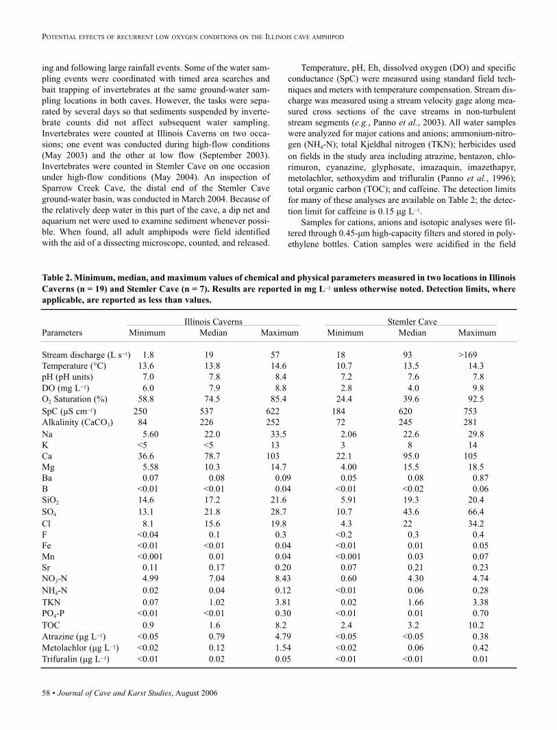
Table 2. Minimum, median, and maximum values of chemical and physical parameters measured in two locations in Illinois
Caverns (n = 19) and Stemler Cave (n = 7). Results are reported in mg L–1 unless otherwise noted. Detection limits, where
applicable, are reported as less than values.
Illinois Caverns Stemler Cave
Parameters Minimum Median Maximum Minimum Median Maximum
Stream discharge (L s–1) 1.8 19 57 18 93 >169
Temperature (°C) 13.6 13.8 14.6 10.7 13.5 14.3
pH (pH units) 7.0 7.8 8.4 7.2 7.6 7.8
DO (mg L–1) 6.0 7.9 8.8 2.8 4.0 9.8
O2 Saturation (%) 58.8 74.5 85.4 24.4 39.6 92.5
SpC (µS cm–1) 250 537 622 184 620 753
Alkalinity (CaCO3) 84 226 252 72 245 281
Na 5.60 22.0 33.5 2.06 22.6 29.8
K <5 <5 13 3 8 14
Ca 36.6 78.7 103 22.1 95.0 105
Mg 5.58 10.3 14.7 4.00 15.5 18.5
Ba 0.07 0.08 0.09 0.05 0.08 0.87
B <0.01 <0.01 0.04 <0.01 <0.02 0.06
SiO2 14.6 17.2 21.6 5.91 19.3 20.4
SO4 13.1 21.8 28.7 10.7 43.6 66.4
Cl 8.1 15.6 19.8 4.3 22 34.2
F <0.04 0.1 0.3 <0.2 0.3 0.4
Fe <0.01 <0.01 0.04 <0.01 0.01 0.05
Mn <0.001 0.01 0.04 <0.001 0.03 0.07
Sr 0.11 0.17 0.20 0.07 0.21 0.23
NO3-N 4.99 7.04 8.43 0.60 4.30 4.74
NH4-N 0.02 0.04 0.12 <0.01 0.06 0.28
TKN 0.07 1.02 3.81 0.02 1.66 3.38
PO4-P <0.01 <0.01 0.30 <0.01 0.01 0.70
TOC 0.9 1.6 8.2 2.4 3.2 10.2
Atrazine (µg L–1) <0.05 0.79 4.79 <0.05 <0.05 0.38
Metolachlor (µg L–1) <0.02 0.12 1.54 <0.02 0.06 0.42
Trifuralin (µg L–1) <0.01 0.02 0.05 <0.01 <0.01 0.01
Journal of Cave and Karst Studies, August 2006 • 59
PANNO, HACKLEY, KELLY, HWANG, WILHELM, TAYLOR, AND STIFF
with ultra-pure nitric acid to a pH of < 2. All samples were
transported to the laboratory in ice-filled coolers and kept
refrigerated at approximately 4° C until analysis.
Cation concentrations were determined with an inductive-
ly coupled argon plasma spectrometer, and anions were deter-
mined by ion chromatography as described in Panno et al.(2001). TKN and NH4-N were determined colorimetrically as
described in Panno et al. (2006). Organic N was operationally
defined as the difference between TKN and NH4-N. Herbicides
were determined with gas chromatography-mass spectrometry
techniques using USEPA Method 508 (USEPA, 1988).
Caffeine was determined using high performance liquid chro-
matography. TOC was determined using a carbon analyzer.
Optical brighteners were measured during one sampling
episode. The presence of optical brighteners in water is a
strong indication of the presence of septic effluent (Alhajjar etal., 1990). White cotton fabric devoid of optical brighteners
was placed in both cave streams in February 2004 and
retrieved the following week. Samples were analyzed with a
spectrofluorophotometer using a technique described by Aley
(1985).
RESULTS AND DISCUSSION
CHEMICAL COMPOSITION OF CAVE GROUND WATER
There were no statistically significant differences in the
chemical composition of the cave-stream water in the two
sample locations within Illinois Caverns, and the composition
was within the normal range for karst ground water in this
region (Panno et al., 1996). Thus, we combined the results
from both locations within Illinois Caverns when comparing
them to Stemler Cave. The range and median of parameter
concentrations from each sampling site were used as descrip-
tors; mean values were not used because they are easily biased
by extreme values.
There were differences in stream water quality between
Stemler Cave and Illinois Caverns (Table 2; Fig. 3). The results
of this investigation showed that Stemler Cave water general-
ly had higher concentrations of TOC, potassium (K+), chloride
(Cl–), sulfate (SO42–) and manganese (Mn), and lower pH and
NO3-N concentrations than Illinois Caverns. Phosphate (PO4-
P) was detected in four of seven Stemler Cave samples but
only two of sixteen Illinois Caverns samples. The differences
were statistically significant for K+, SO42–, Cl–, and NO3-N, as
Figure 3. Box and whisker plots comparing stream water
quality in Illinois Caverns (n = 19) and Stemler Cave (n =
7). Whiskers are missing from the Stemler Cave data
because there were an inadequate number of samples to
calculate the 5th and 95th percentiles.
Figure 4. Percent O2 saturation in cave streams as a func-
tion of stream discharge in Illinois Caverns and Stemler
Cave. Stemler Cave exhibited a very low % O2 saturation
at low flow.
Figure 5. DO vs TOC concentrations of Illinois Caverns
and Stemler Cave stream-water samples. Stemler Cave
water exhibits a relationship with TOC not seen in Illinois
Caverns water.
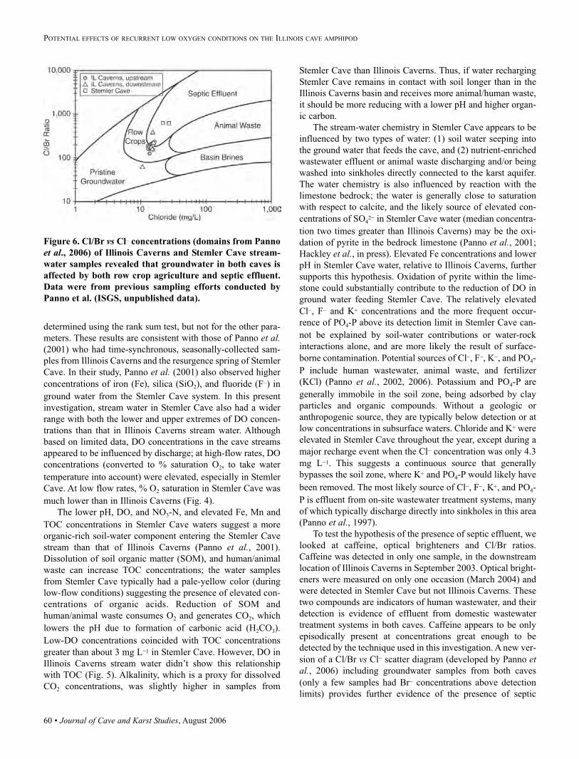
60 • Journal of Cave and Karst Studies, August 2006
POTENTIAL EFFECTS OF RECURRENT LOW OXYGEN CONDITIONS ON THE ILLINOIS CAVE AMPHIPOD
determined using the rank sum test, but not for the other para-
meters. These results are consistent with those of Panno et al.(2001) who had time-synchronous, seasonally-collected sam-
ples from Illinois Caverns and the resurgence spring of Stemler
Cave. In their study, Panno et al. (2001) also observed higher
concentrations of iron (Fe), silica (SiO2), and fluoride (F–) in
ground water from the Stemler Cave system. In this present
investigation, stream water in Stemler Cave also had a wider
range with both the lower and upper extremes of DO concen-
trations than that in Illinois Caverns stream water. Although
based on limited data, DO concentrations in the cave streams
appeared to be influenced by discharge; at high-flow rates, DO
concentrations (converted to % saturation O2, to take water
temperature into account) were elevated, especially in Stemler
Cave. At low flow rates, % O2 saturation in Stemler Cave was
much lower than in Illinois Caverns (Fig. 4).
The lower pH, DO, and NO3-N, and elevated Fe, Mn and
TOC concentrations in Stemler Cave waters suggest a more
organic-rich soil-water component entering the Stemler Cave
stream than that of Illinois Caverns (Panno et al., 2001).
Dissolution of soil organic matter (SOM), and human/animal
waste can increase TOC concentrations; the water samples
from Stemler Cave typically had a pale-yellow color (during
low-flow conditions) suggesting the presence of elevated con-
centrations of organic acids. Reduction of SOM and
human/animal waste consumes O2 and generates CO2, which
lowers the pH due to formation of carbonic acid (H2CO3).
Low-DO concentrations coincided with TOC concentrations
greater than about 3 mg L–1 in Stemler Cave. However, DO in
Illinois Caverns stream water didn’t show this relationship
with TOC (Fig. 5). Alkalinity, which is a proxy for dissolved
CO2 concentrations, was slightly higher in samples from
Stemler Cave than Illinois Caverns. Thus, if water recharging
Stemler Cave remains in contact with soil longer than in the
Illinois Caverns basin and receives more animal/human waste,
it should be more reducing with a lower pH and higher organ-
ic carbon.
The stream-water chemistry in Stemler Cave appears to be
influenced by two types of water: (1) soil water seeping into
the ground water that feeds the cave, and (2) nutrient-enriched
wastewater effluent or animal waste discharging and/or being
washed into sinkholes directly connected to the karst aquifer.
The water chemistry is also influenced by reaction with the
limestone bedrock; the water is generally close to saturation
with respect to calcite, and the likely source of elevated con-
centrations of SO42– in Stemler Cave water (median concentra-
tion two times greater than Illinois Caverns) may be the oxi-
dation of pyrite in the bedrock limestone (Panno et al., 2001;
Hackley et al., in press). Elevated Fe concentrations and lower
pH in Stemler Cave water, relative to Illinois Caverns, further
supports this hypothesis. Oxidation of pyrite within the lime-
stone could substantially contribute to the reduction of DO in
ground water feeding Stemler Cave. The relatively elevated
Cl–, F– and K+ concentrations and the more frequent occur-
rence of PO4-P above its detection limit in Stemler Cave can-
not be explained by soil-water contributions or water-rock
interactions alone, and are more likely the result of surface-
borne contamination. Potential sources of Cl–, F–, K–, and PO4-
P include human wastewater, animal waste, and fertilizer
(KCl) (Panno et al., 2002, 2006). Potassium and PO4-P are
generally immobile in the soil zone, being adsorbed by clay
particles and organic compounds. Without a geologic or
anthropogenic source, they are typically below detection or at
low concentrations in subsurface waters. Chloride and K+ were
elevated in Stemler Cave throughout the year, except during a
major recharge event when the Cl– concentration was only 4.3
mg L–1. This suggests a continuous source that generally
bypasses the soil zone, where K+ and PO4-P would likely have
been removed. The most likely source of Cl–, F–, K+, and PO4-
P is effluent from on-site wastewater treatment systems, many
of which typically discharge directly into sinkholes in this area
(Panno et al., 1997).
To test the hypothesis of the presence of septic effluent, we
looked at caffeine, optical brighteners and Cl/Br ratios.
Caffeine was detected in only one sample, in the downstream
location of Illinois Caverns in September 2003. Optical bright-
eners were measured on only one occasion (March 2004) and
were detected in Stemler Cave but not Illinois Caverns. These
two compounds are indicators of human wastewater, and their
detection is evidence of effluent from domestic wastewater
treatment systems in both caves. Caffeine appears to be only
episodically present at concentrations great enough to be
detected by the technique used in this investigation. A new ver-
sion of a Cl/Br vs Cl– scatter diagram (developed by Panno etal., 2006) including groundwater samples from both caves
(only a few samples had Br– concentrations above detection
limits) provides further evidence of the presence of septic
Figure 6. Cl/Br vs Cl– concentrations (domains from Panno
et al., 2006) of Illinois Caverns and Stemler Cave stream-
water samples revealed that groundwater in both caves is
affected by both row crop agriculture and septic effluent.
Data were from previous sampling efforts conducted by
Panno et al. (ISGS, unpublished data).

Journal of Cave and Karst Studies, August 2006 • 61
PANNO, HACKLEY, KELLY, HWANG, WILHELM, TAYLOR, AND STIFF
effluent in Stemler Cave and, to a lesser extent, Illinois
Caverns (Fig. 6). The relatively low Cl/Br ratio precludes road
salt from being the source of Cl– (Panno et al., 2006). The
infiltration of septic effluent into the shallow karst aquifer is
also consistent with the lack of seasonal trends for Cl– and K+,
because effluent would be introduced into the hydrologic sys-
tem year round. Elevated TOC and lower DO in Stemler Cave
may also be due in part to a greater influx of septic effluent.
Boron, another element associated with wastewater, was
detected (> 0.01 mg L–1) in about 5% of Illinois Caverns sam-
ples, whereas, it was detected in about 38% of the Stemler
Cave samples. Livestock are present, but uncommon within
the ground-water basins. Contamination of both Illinois
Caverns and Stemler Cave by human/animal waste has been
reported previously; enteric bacteria, sometimes at very high
levels, are almost always detected when these cave streams
have been tested (Panno et al., 1996; Taylor et al., 2000).
Herbicides have been shown to have adverse impacts on
aquatic biota (U.S. Fish and Wildlife Service, 2002), but the
fact that herbicides were detected in both Illinois Caverns and
Stemler Cave, and at higher concentrations in Illinois Caverns,
suggests that they alone are not responsible for the extirpation
of G. acherondytes from Stemler Cave. The herbicides further
suggest that there was a stronger agricultural influence within
the Illinois Caverns ground-water basin.
CAVE BIOTA
Gammarus acherondytes was found in both upstream and
downstream locations in Illinois Caverns in surveys undertak-
en in May 2003 and September 2003. Populations were rough-
ly equal at both locations in spite of previous extirpation in the
downstream reaches. Gammarus acherondytes was not detect-
ed in Stemler Cave in a survey during May 2004 or during
reconnaissance trips in November 2003 and March 2004 to
Sparrow Creek Cave, the resurgence of the Stemler Cave
ground-water basin, located several km to the north (Fig. 2).
The presence of biofilms and total absence of cave biota with-
in Sparrow Creek Cave suggests the possible discharge of ani-
mal and/or human waste prior to the survey. No similar
biofilms were observed in Illinois Caverns during or prior to
this investigation. In July 2000, Lewis (2003) conducted a sur-
vey in Spider Cave, a small cave located about 1 km to the
north of the entrance to Illinois Caverns. Within the cave sys-
tem, there was a strong, putrid odor and evidence of sewage
and/or animal waste. Lewis (2003) reported that a putrid,
microbial mat covered all surfaces and was present in inter-
stices within the cave; the microbial mat and odor were gone
by the following September 2000. Subsequent work by F.
Wilhelm at Spider Cave in September 2003 revealed no addi-
tional microbial mats or odor and G. acherondytes had
returned. High levels of bacterial contamination associated
with human and livestock waste have been shown to have
impacted cave communities elsewhere in the eastern United
States (Poulson, 1991; Simon and Buikema, 1997). In Virginia,
Caecidotea recurvata (Steeves), an asellid isopod, had a high-
er tolerance for waters negatively influenced by septic effluent
than did the gammarid amphipod Stygobromus mackiniHubricht. Elsewhere in Virginia, Culver et al. (1992) attributed
the extirpation of the stygobitic crangonyctid amphipod
Crangonyx antennatus Packard and the asellid isopods C.recurvata and Lirceus usdagalun Holsinger and Bowman to
increased flux of organic pollutants in the karst system. These
observations suggest that discharge or dumping of sewage
and/or animal waste in the sinkhole plain may occur and could
be responsible for the apparent extirpation of G. acherondytesfrom cave streams.
CONSEQUENCES TO CAVE BIOTA
Probably the most important difference that we observed in
the chemical composition between the two cave streams is the
periodically low DO concentrations in Stemler Cave.
Differences in other chemical parameters do not appear to vary
sufficiently to account for the apparent absence of G.acherondytes from Stemler Cave and its continued presence in
Illinois Caverns. Low-DO concentrations are known to be
deleterious to aquatic organisms; average DO concentrations
less than 3 mg L–1 are stressful for aquatic organisms, and con-
centrations less than 2 mg L–1 are defined as hypoxic (SCDNR,
2004). The lowest measured DO concentration in Stemler
Cave was 2.8 mg L–1, and it is possible that even lower con-
centrations can occur. We conclude that of all the chemical
data we examined, low DO is the most likely cause contribut-
ing to the apparent loss of G. acherondytes from Stemler Cave.
Even though we have a limited number of samples, the DO
concentrations in Stemler Cave stream water were depressed
(and possibly hypoxic) during periods of low flow. The loss of
all biota at the resurgence of Stemler Cave (Sparrow Creek
Cave) and observations of the formation of biofilm on rocks
and walls of the cave suggest that the aquatic biota of Stemler
Cave are subjected to periodic low oxygen stress. This likely
resulted from periodic and some continuous influx of human
and/or animal waste. Such a reduction of DO is often respon-
sible for the decline of aquatic biota in waters receiving organ-
ic waste.
Taylor et al. (2003) suggested that cave facultative
amphipods such as Gammarus troglophilus could out-compete
(through numerical displacement) G. acherondytes because of
metabolic advantages under heightened-food conditions in
caves. Although the lower metabolic rate of G. acherondyteswould have an advantage in a “food-poor hypogean environ-
ment” such as a near pristine cave, urbanization and the influx
of abundant organic matter from anthropogenic sources (e.g.,septic effluent) would favor the proliferation of G. troglophilus(Wilhelm et al., 2006). The influx of organic materials into the
cave streams would increase in severity with greater anthro-
pogenic surface activities (e.g., Panno et al., 1996, Simon and
Buikema 1997). We speculate that because of the metabolic
advantage of the stygophilic biota, the stygobitic G. acher-oudytes may not have had as wide a range in the Stemler Cave
ground-water basin as did the other aquatic invertebrates,
thereby allowing the other aquatic invertebrates (but not G.
62 • Journal of Cave and Karst Studies, August 2006
POTENTIAL EFFECTS OF RECURRENT LOW OXYGEN CONDITIONS ON THE ILLINOIS CAVE AMPHIPOD
acherondytes) to recolonize Stemler Cave following periods of
low DO in the cave stream.
The recent (since 2000) repopulation of downstream reach-
es in Illinois Caverns by G. acherondytes suggests either the
quality of water recharging the cave has improved or that the
distribution of G. acherondytes is sufficiently widespread in
the cave to allow repopulation following low oxygen episodes
in parts of the stream. This also suggests that the timing of
population surveys (i.e., amount of time following hypoxic
episodes), is critical to accurately determining the abundance
of invertebrate populations.
CONCLUSIONS
During this investigation, G. acherondytes was found in
both upstream and downstream locations in Illinois Caverns,
contrary to previous surveys when it was nearly absent from
downstream reaches. This can be attributed to timing of sur-
veys, improved water quality, or, more likely, periodic loss and
repopulation of the amphipod in the downstream reaches of
Illinois Caverns. Multiple surveys over the past 40 years sup-
port a conclusion that G. acherondytes has been extirpated
from Stemler Cave; however, it is possible that the amphipod
may exist in small tributaries within the ground-water basin
and have the potential to repopulate the cave stream if the
water quality improves. Stemler Cave stream-water samples
had higher concentrations of TOC, K+, Cl–, F–, SO42–, SiO2, Fe
and Mn, and lower NO3-N and pH than those from Illinois
Caverns, and most importantly experienced substantially
lower DO concentrations. The dominant influence on Illinois
Caverns stream water appears to be agricultural. Whereas,
Stemler Cave stream water appears to be influenced by two
distinct sources: one with a large soil water component and the
other with a human wastewater/animal waste component, the
organic matter of which could contribute to low-DO concen-
trations. This characterization is further supported by the fact
that the percentage of urban land use in the Stemler Cave
ground-water basin is about eight times greater that in the
ground-water basin of Illinois Caverns.
The low DO in Stemler Cave apparently occurs only dur-
ing low-flow conditions, causing the cave stream aquatic
invertebrates to periodically (seasonally?) experience low-
oxygen conditions and increased stress. The presence of opti-
cal brightener, wastewater microbial taxa, and the results of
Cl/Br vs Cl– scatter diagrams of Illinois Caverns and Stemler
Cave water suggest that effluent from wastewater-treatment
systems is also entering their ground-water basins, most likely
through discharge into sinkholes. This situation would make
organics (a heightened-food condition) much more abundant
within the caves. Based on land-use data, the ground-water
basin of Stemler Cave could contain at least eight times more
private septic systems that that of Illinois Caverns. Dissolved
oxygen is probably lost not only from degradation of human
waste, but also from degradation of SOM, as well as pyrite oxi-
dation. We speculate that because of metabolic differences
between G. acherondytes and other aquatic invertebrates, G.acherondytes may not have had as wide a range in the Stemler
Cave ground-water basin as the other aquatic invertebrates.
This situation would allow them, but not G. acherondytes, to
recolonize the downstream reaches of the cave following peri-
ods of low DO. The fact that cave facultative amphipods have
a metabolic advantage over G. acherondytes under heightened-
food conditions probably led to its displacement and apparent
extirpation from Stemler Cave.
ACKNOWLEDGMENTS
The authors thank Chris Hespen, former Site Interpreter at
Illinois Caverns, and Superintendent Vic Hamer at the Illinois
Department of Natural Resources (IDNR) for their assistance
in gaining access to Illinois Caverns. We thank Loretta Stemler
and Bob and Nancy Weck for allowing access to Stemler Cave
and Eric Harr for allowing access to Sparrow Creek Cave. We
also thank Pam Carrillo, Dan Byers, Joel Steinfeldt, Joel
Dexter (ISGS), JoAnn Jacoby, Stacey Clementz (University of
Illinois), Philip Moss (Ozark Underground Laboratory) and
Mike Venarsky (Southern Illinois University at Carbondale)
for their assistance in the field. This research by the ISGS and
The INHS was supported by grant number G2003123 from the
U.S. Fish and Wildlife Service through the Illinois Department
of Natural Resources to the University of Illinois Board of
Trustees. Glen Kruse was project manager for the grant.
Publication of this article has been authorized by the Chiefs of
the Illinois State Geological Survey, Illinois State Water
Survey, and Illinois Natural History Survey.
REFERENCES
Aley, T.J., 1985, Optical brightener sampling; A reconnais-
sance tool for detecting sewage in karst groundwater:
Hydrogeological Science and Technology Short Papers, v. 1,
p. 45–48.
Aley, T., Moss, P., and Aley, C., 2000, Delineation of recharge
areas for four biologically significant cave systems in
Monroe and St. Clair Counties, Illinois: Unpublished final
report to the Illinois Nature Preserves Commission and
Monroe County Soil and Water Conservation District, 254 p.
Alhajjar, B.J., Chesters, G., and Harkin, J.M., 1990, Indicators
of chemical pollution from septic systems: Ground Water, v.
28, no. 4, p. 559–568.
Culver, D.C., Jones, W.K., and Holsinger, J.R., 1992,
Biological and hydrological investigation of the Cedars, Lee
County, Virginia: An ecologically significant and threatened
karst area. In Stanford, J.A. and Simons, J.J., eds.,
Proceedings of the 1st International Conference on Ground
Water Ecology, p. 281–290.
Hackley, K.C., Panno, S.V., Hwang, H.H. and Kelly, W.R.,
Groundwater quality of springs and wells of the sinkhole
plain in southwestern Illinois: Determination of the dominant
sources of nitrate: Illinois State Geological Survey Circular
566. [in press].
Journal of Cave and Karst Studies, August 2006 • 63
PANNO, HACKLEY, KELLY, HWANG, WILHELM, TAYLOR, AND STIFF
Herzog, B.L., Stiff, B.J., Chenoweth, C.A., Warner, K.L.,
Sieverling, J.B. and Avery, C., 1994, Buried bedrock surface
of Illinois. Illinois State Geological Survey, Illinois Map 5.
1:500,000.
Lewis, J.J., 2000, Establishing a methodology for non-lethal
censusing of Gammarus acherondytes populations in cave
stream communities of southwestern Illinois. Final Report:
U.S. Fish and Wildlife Service and Illinois Department of
Natural Resources, 35 p.
Lewis, J.J., 2003, The 2003 non-lethal censusing of Gammarusacherondytes communities in southwestern Illinois: Final
report Endangered Species Program. U.S. Fish and Wildlife
Service, 62 p.
Lewis, J.J., Moss, P., Tecic, D., and Nelson, M.E., 2003, A con-
servation focused inventory of subterranean invertebrates of
the southwestern Illinois karst: Journal of Cave and Karst
Studies, v. 65, no. 1, p. 9–21.
Panno, S.V., Krapac, I.G., Weibel, C.P., and Bade, J.D., 1996,
Groundwater contamination in karst terrain of southwestern
Illinois: Illinois State Geological Survey, Environmental
Geology Series 151, 43 p.
Panno, S.V., Weibel, C.P., Krapac, I.G., and Storment, E.C.,
1997, Bacterial contamination of groundwater from private
septic systems in Illinois’ sinkhole plain: Regulatory consid-
erations. In The Engineering Geology and Hydrogeology of
Karst Terranes. Beck, B.F. and Stephenson, J.B., eds.
Proceedings of the Sixth Multidisciplinary Conference on
Sinkholes and the Engineering and Environmental Impacts
of Karst. Springfield, MO. April 6-9, 1997, p. 443–447.
Panno, S.V., Hackley, K.C., Hwang, H.H., and Kelly, W.R.,
2001, Determination of the sources of nitrate contamination
in karst springs using isotopic and chemical indicators:
Chemical Geology, v. 179, p. 113–128.
Panno, S.V., Kelly, W.R., Hackley, K.C., and Hwang, H.H.,
2002, Distribution and sources of heterotrophic bacteria in
wells, caves and springs of a karst aquifer in the Midwestern
U.S. In Karst Waters Institute Special Publication 7, p.
92–94.
Panno, S.V., Greenberg, S.E., Weibel, C.P., and Gillespie, P.K.,
2004, Guide to the Illinois Caverns State Natural Area:
Illinois State Geological Survey GeoScience Education
Series 19, 106 p.
Panno, S.V., Angel, J., and. Weibel, C.P,. Sinkhole density of
the Renault 7.5 minute quadrangle: Illinois State Geological
Survey IPGM. In press a.
Panno, S.V., Angel, J., and Weibel, C.P., Sinkhole density of
the Columbia 7.5 minute quadrangle: Illinois State
Geological Survey IPGM. In press b.
Panno, S.V., Kelly, W.R., Weibel, C.P., Krapac, I.G., and
Sargent, S.L., 2003, Water quality and agrichemical loading
in two groundwater basins of Illinois’ sinkhole plain: Illinois
State Geological Survey Environmental Geology Series, EG
156, 36 p.
Panno, S.V., Hackley, K.C., Hwang, H.H., Greenberg, S.E.,
Krapac, I.G., Landsberger, S., and O’Kelly, D.J., 2006,
Characterization and identification of Na-Cl sources in
ground water: Ground Water, v. 44, p. 176–187.
Peck, S.B. and Lewis, J.J., 1978, Zoogeography and evolution
of the subterranean invertebrate faunas of Illinois and south-
eastern Missouri: National Speleological Society Bulletin, v.
40, no. 2, p. 730–740.
Poulson, T.L. 1991. Assessing groundwater quality in caves
using indices of biological integrity. In Proceedings of the
Third Conference on Hydrology, Ecology, Monitoring and
Management of Groundwater in Karst Terrains. December,
1991, Nashville, TN, p. 495–511.
SCDNR, 2004, Water Quality. South Carolina Department of
Natural Resources (SCDNR).
http://water.dnr.state.sc.us/marine/scecap/content_findingswq.htm
[accessed February 4, 2005].
Simon, K.S. and Buikema, A.L., 1997, Effects of organic pol-
lution on an Appalachian cave: Changes in macroinverte-
brate populations and food supplies. American Midland
Naturalist, v. 138, no. 2, p. 387–401.
Taylor, S.J. and Webb, D.W., 2000, Subterranean Amphipoda
(Crustacea) of Illinois’ Salem Plateau: Spacial and temporal
components of microdistribution: Illinois Natural History
Survey Technical Report 2000 (27), 62 p.
Taylor, S.J., Webb, D.W., and Panno, S.V., 2000, Spatial and
temporal analyses of the bacterial fauna and water, sediment,
and amphipod tissue chemistry within the range of
Gammarus acherondytes: Illinois Natural History Survey
Technical Report 2000.
Taylor, S.J., Wilhelm, F.M., Adams, G.L., and Venarsky, M.P.,
2003, Establishing baseline data on seasonal physiological
requirements for Gammarus acherondytes and Gammarustroglophilus in relation to microbial oxygen demand: Illinois
Natural History Survey Technical Report 2003 (20), 50 p.
U.S. Fish and Wildlife Service (USFWS), 2002, Illinois Cave
amphipod (Gammarus acherondytes) recovery plan: U.S.
Fish and Wildlife Service, Ft. Snelling, Minnesota. vi + 63 p.
U.S. Environmental Protection Agency (USEPA), 1988,
Methods for the determination of organic compounds in
drinking water. Methods 508 and 525: U.S. Environmental
Protection Agency, EPA-600/4-88/039.
Venarsky, M.P., 2005, The life history and population genetics
of the endangered Illinois cave amphipod, Gammarusacherondytes (GAMMARIDEA): [Master’s thesis]:
Southern Illinois University, Carbondale, IL. 72 p.
Webb, D.W., 1995, Status report on the cave amphipod
Gammarus acherondytes Hubricht and Mackin (Crusteacea;
Amphipoda) in Illinois: Illinois Natural History Survey
Technical Report 1995 (22), 22 p.
Wilhelm, F.M., Taylor, S.J., and Adams, G.L., 2006,
Comparison of routine metabolic rates of the stygobite,
Gammarus acherondytes (Amphipoda: Gammaridae) and
the stygophile, Gammarus troglophilus: Freshwater Biology,
v. 51, p. 1162–1174.
White, W.B., 1988, Geomorphology and hydrology of karst
terrains: Oxford University Press, New York, 464 p.
64 • Journal of Cave and Karst Studies, August 2006
Lee J. Florea – Architecture of air-filled caves within the karst of the Brooksville Ridge, west-central Florida. Journal of Cave and Karst Studies, v. 68, no. 2, p.
64–75.
INTRODUCTION
Cavers and karst scientists have long appreciated and
recorded information concerning the morphology of passages
in caves. These data about caves are important to understand-
ing the flow of water in karst aquifers, which cover approxi-
mately 15% of the land surface and provide water to approxi-
mately one-fifth of the world’s population (Ford and Williams,
1989). For example, compilations of cave maps reveal patterns
in both the organization of passages in a cave and the shape of
individual passage cross-sections that are a direct consequence
of hydrogeological conditions within karst aquifers (e.g.,Palmer, 2000; White 1988). To date, these observations are
drawn primarily from experiences in caves formed far from the
influence of the coast and within ancient carbonate rocks that
are remarkably different from carbonate rocks that are geolog-
ically recent or are forming today. This paper presents a case
study of the morphology of caves within the coastal karst
aquifers of west-central Florida.
GEOLOGIC FRAMEWORK OF THE BROOKSVILLE RIDGE AND THE
UPPER FLORIDAN AQUIFER
The Tertiary limestones that compose the highly productive
Upper Floridan Aquifer are intensely karstified in regions that
experience active groundwater circulation (e.g., Lane, 1986;
Stringfield and LeGrand, 1966), particularly in the portion of
west-central Florida where the Upper Floridan Aquifer is semi-
confined to unconfined. This region, characterized by 33
springs with average discharge greater than 2.8 m3 s–1 (e.g.,Scott et al., 2004; Roseneau et al., 1977; Meinzer, 1927),
stretches from the panhandle near Tallahassee in the north to
Tampa in peninsular Florida (Fig. 1A) and encompasses sever-
al physiographic provinces including the Brooksville Ridge
(White, 1970).
The Brooksville Ridge, a linear, positive-relief topograph-
ic feature extending from northern Citrus County, through
Hernando County, and into southern Pasco County (White,
1970), is bounded by coastal lowlands to the west and south
and wetlands of the Withlacoochee River to the east and north.
The ridge system is a consequence of a localized geologic high
termed the Ocala Platform by Scott (1988), who attributed this
topographic feature to a westward tilt of thickened Eocene
strata. Elevations in the Brooksville Ridge range from five to
more than 75 m above sea level (Fig. 1B). The topography is
rolling with internal drainage (Fig. 2). Upland mesic-hard-
wood hammocks separate sinkhole lowlands that are mostly
occupied by wetlands or lakes. The Withlacoochee State Forest
manages more than 525 km2 (157,000 acres) in the region,
including the 100-km2 (30,000 acre) Citrus Tract that includes
much of the study area. Pasture land and lime-rock quarries
compose the remaining land uses. The city of Brooksville lies
in the heart of the Brooksville Ridge (Fig. 1A).
Upper-Eocene and Oligocene carbonates (42–33 Mya)
compose the Upper Floridan Aquifer, which is semi-confined
to unconfined in the Brooksville Ridge. The strata of the Upper
Floridan Aquifer thicken to the south along a regional dip that
averages less than half of one degree (Scott et al., 2001; Miller
et al., 1986). Miocene-age sands and clays of the Hawthorn
Group thicken to more than 150 m in northern and southern
Florida where the Upper Floridan Aquifer is confined (Scott,
1988). The Hawthorn Group is thin to missing in the center of
the Brooksville Ridge in northern Hernando and southern
Citrus Counties (Fig. 3).
The Suwannee Limestone, a pale-orange, partially recrys-
tallized limestone that is extensively quarried in northern
Hernando County, is more than 30 m thick to the south. In the
up-dip sections of the northern Brooksville Ridge of Citrus
County, the Suwannee Limestone is thin to nonexistent as a
ARCHITECTURE OF AIR-FILLED CAVES WITHIN THE
KARST OF THE BROOKSVILLE RIDGE,
WEST-CENTRAL FLORIDALEE J. FLOREA
Department of Geology, University of South Florida, Tampa, FL 33620, [email protected]
Air-filled caves surveyed in the Brooksville Ridge of west-central Florida provide insight into the orga-nization of karstic permeability within the unconfined portions of the Upper Floridan Aquifer. The mor-phology of the passages that compose these caves in geologically young, high-permeability limestones isstrikingly different from caves found in ancient carbonates far from the influence of the coast. Cave pas-sages in west-central Florida are laterally extensive and tiered. Principal horizons of cave developmentoccur between +3 m and +5 m, +12 m and +15 m, and +20 m and +22 m above modern sea level. Theprimary guide of cave passage orientations within these cave levels is widespread fractures orientedapproximately NE-SW and NW-SE. Cave passages of human dimensions form at the intersection of thelaterally extensive cavities and fractures and often acquire a characteristic plus-sign shape. The walls ofcave passages in west-central Florida are porous and complex, with small-scale solution features suchas pockets and tafoni structures extending into the host bedrock. Additionally, these cave passages oftenend in blind pockets, ever-narrowing fissures, sediment fills, and collapses. The passages do not appearto represent an integrated system of conduits between aquifer inputs and outputs.
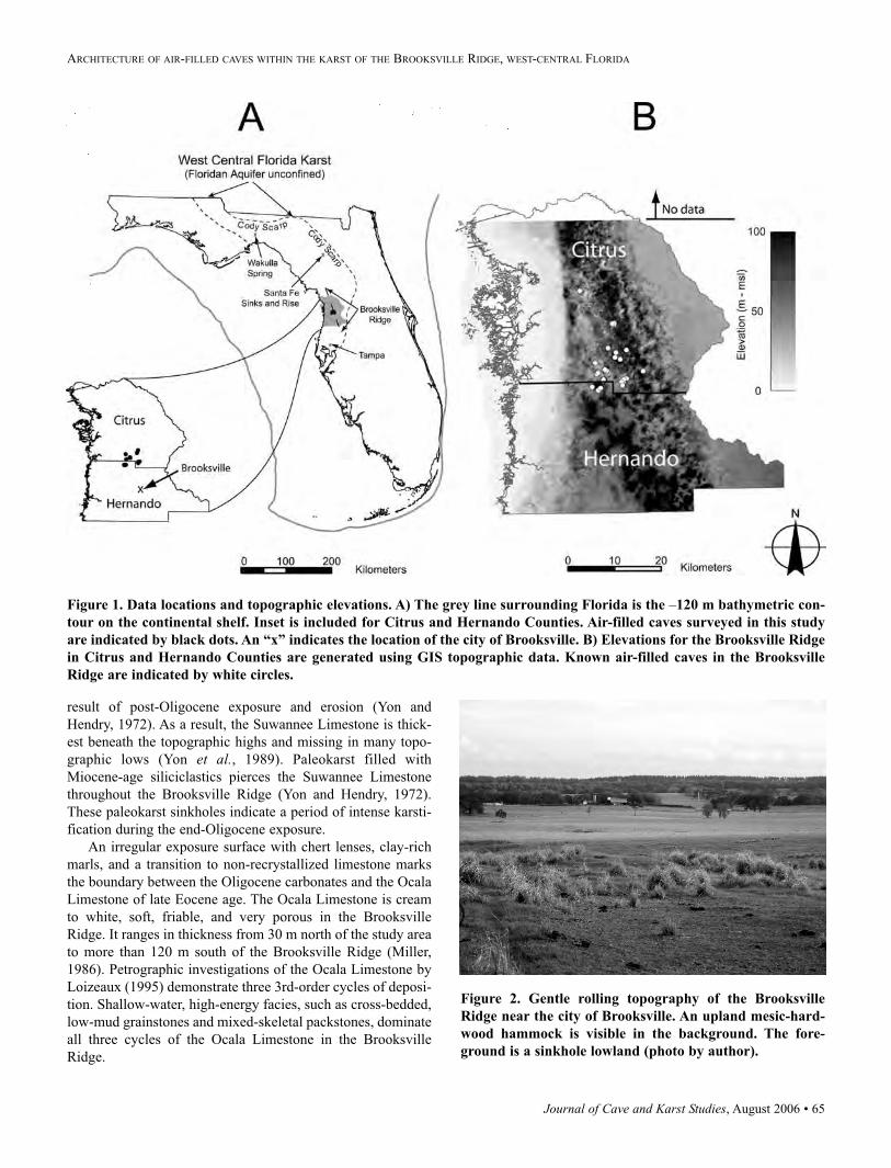
Journal of Cave and Karst Studies, August 2006 • 65
ARCHITECTURE OF AIR-FILLED CAVES WITHIN THE KARST OF THE BROOKSVILLE RIDGE, WEST-CENTRAL FLORIDA
result of post-Oligocene exposure and erosion (Yon and
Hendry, 1972). As a result, the Suwannee Limestone is thick-
est beneath the topographic highs and missing in many topo-
graphic lows (Yon et al., 1989). Paleokarst filled with
Miocene-age siliciclastics pierces the Suwannee Limestone
throughout the Brooksville Ridge (Yon and Hendry, 1972).
These paleokarst sinkholes indicate a period of intense karsti-
fication during the end-Oligocene exposure.
An irregular exposure surface with chert lenses, clay-rich
marls, and a transition to non-recrystallized limestone marks
the boundary between the Oligocene carbonates and the Ocala
Limestone of late Eocene age. The Ocala Limestone is cream
to white, soft, friable, and very porous in the Brooksville
Ridge. It ranges in thickness from 30 m north of the study area
to more than 120 m south of the Brooksville Ridge (Miller,
1986). Petrographic investigations of the Ocala Limestone by
Loizeaux (1995) demonstrate three 3rd-order cycles of deposi-
tion. Shallow-water, high-energy facies, such as cross-bedded,
low-mud grainstones and mixed-skeletal packstones, dominate
all three cycles of the Ocala Limestone in the Brooksville
Ridge.
Figure 1. Data locations and topographic elevations. A) The grey line surrounding Florida is the –120 m bathymetric con-
tour on the continental shelf. Inset is included for Citrus and Hernando Counties. Air-filled caves surveyed in this study
are indicated by black dots. An “x” indicates the location of the city of Brooksville. B) Elevations for the Brooksville Ridge
in Citrus and Hernando Counties are generated using GIS topographic data. Known air-filled caves in the Brooksville
Ridge are indicated by white circles.
Figure 2. Gentle rolling topography of the Brooksville
Ridge near the city of Brooksville. An upland mesic-hard-
wood hammock is visible in the background. The fore-
ground is a sinkhole lowland (photo by author).
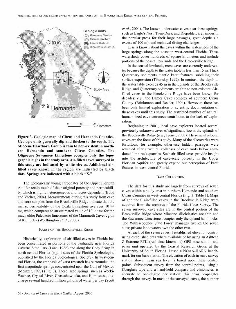
66 • Journal of Cave and Karst Studies, August 2006
ARCHITECTURE OF AIR-FILLED CAVES WITHIN THE KARST OF THE BROOKSVILLE RIDGE, WEST-CENTRAL FLORIDA
The geologically young carbonates of the Upper Floridan
Aquifer retain much of their original porosity and permeabili-
ty, which is highly heterogeneous and facies-dependent (Budd
and Vacher, 2004). Measurements during this study from cave
and core samples from the Brooksville Ridge indicate that the
matrix permeability of the Ocala Limestone averages 10–12.7
m2, which compares to an estimated value of 10–17.7 m2 for the
much older Paleozoic limestones of the Mammoth Cave region
of Kentucky (Worthington et al., 2000).
KARST OF THE BROOKSVILLE RIDGE
Historically, exploration of air-filled caves in Florida has
been concentrated in portions of the panhandle near Florida
Caverns State Park (Lane, 1986) and along the Cody Scarp in
north-central Florida (e.g., issues of the Florida Speleologist,
published by the Florida Speleological Society). In west-cen-
tral Florida, the emphasis of karst research has surrounded the
first-magnitude springs concentrated near the Gulf of Mexico
(Meinzer, 1927) (Fig. 3). These large springs, such as Weeki-
Wachee, Crystal River, Chassahowitzka, and Homosassa, dis-
charge several hundred million gallons of water per day (Scott
et al., 2004). The known underwater caves near these springs,
such as Eagle’s Nest, Twin-Dees, and Diepolder, are famous in
the popular press for their large passages, great depths (in
excess of 100 m), and technical diving challenges.
Less is known about the caves within the watersheds of the
large springs along the coast in west-central Florida. These
watersheds cover hundreds of square kilometers and include
portions of the coastal lowlands and the Brooksville Ridge.
In the coastal lowlands, most caves are currently underwa-
ter because the depth to the water table is less than 15 m. Thick
Quaternary sediments mantle karst features, subduing their
surface expression (Tihansky, 1999). In contrast, the depth to
the water table exceeds 45 m in the uplands of the Brooksville
Ridge, and Quaternary sediments are thin to non-existent. Air-
filled caves in the Brooksville Ridge have been known for
decades; e.g., the Dames Cave complex of southern Citrus
County (Brinkmann and Reeder, 1994). However, there has
been only limited exploration or scientific documentation of
these caves until this study. The restricted number of natural,
human-sized cave entrances contributes to the lack of explo-
ration.
Beginning in 2001, local cave explorers located several
previously unknown caves of significant size in the uplands of
the Brooksville Ridge (e.g., Turner, 2003). These newly-found
caves are the focus of this study. Many of the discoveries were
fortuitous; for example, otherwise hidden passages were
revealed after structural collapses of cave roofs below aban-
doned lime-rock quarries. Such air-filled caves provide insight
into the architecture of cave-scale porosity in the Upper
Floridan Aquifer and greatly expand our perception of karst
features in west-central Florida.
DATA COLLECTION
The data for this study are largely from surveys of seven
caves within a study area in northern Hernando and southern
Citrus Counties in west-central Florida (Fig. 3, Table 1). Maps
of additional air-filled caves in the Brooksville Ridge were
acquired from the archives of the Florida Cave Survey. The
seven surveyed cave sites are in the central portion of the
Brooksville Ridge where Miocene siliciclastics are thin and
the Suwannee Limestone occupies only the upland hammocks.
The Withlacoochee State Forest manages five of the seven
sites; private landowners own the other two.
At each of the seven caves, I established elevation control
using established data where available or by using an Ashtech
Z-Extreme RTK (real-time kinematic) GPS base station and
rover unit operated by the Coastal Research Group at the
University of South Florida. I used a NOAA-HARN bench-
mark for our base station. The elevation of each in-cave survey
station above mean sea level is based upon these control
points. Subsequent survey from the control points, using a
fiberglass tape and a hand-held compass and clinometer, is
accurate to one-degree per station; this error propagates
through the survey. In most of the surveyed caves, the number
Figure 3. Geologic map of Citrus and Hernando Counties.
Geologic units generally dip and thicken to the south. The
Miocene Hawthorn Group is thin to non-existent in north-
ern Hernando and southern Citrus Counties. The
Oligocene Suwannee Limestone occupies only the topo-
graphic highs in the study area. Air-filled caves surveyed in
this study are indicated by white circles. Additional air-
filled caves known in the region are indicated by black
dots. Springs are indicated with a black “X.”
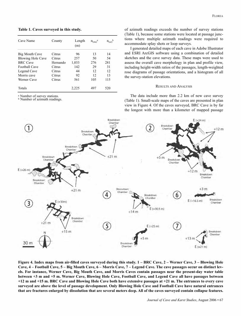
Journal of Cave and Karst Studies, August 2006 • 67
FLOREA
of azimuth readings exceeds the number of survey stations
(Table 1), because some stations were located at passage junc-
tions where multiple azimuth readings were required to
accommodate splay shots or loop surveys.
I generated detailed maps of each cave in Adobe Illustrator
and ESRI ArcGIS software using a combination of detailed
sketches and the cave survey data. These maps were used to
assess the overall cave morphology in plan and profile view,
including height-width ratios of the passages, length-weighted
rose diagrams of passage orientations, and a histogram of all
the survey-station elevations.
RESULTS AND ANALYSIS
The data include more than 2.2 km of new cave survey
(Table 1). Small-scale maps of the caves are presented in plan
view in Figure 4. Of the caves surveyed, BRC Cave is by far
the longest with more than a kilometer of mapped passage
Table 1. Caves surveyed in this study.
Cave Name County Length n(sta)a n(az)
b
(m)
Big Mouth Cave Citrus 96 13 14
Blowing Hole Cave Citrus 257 50 54
BRC Cave Hernando 1,033 276 281
Football Cave Citrus 142 29 31
Legend Cave Citrus 44 12 12
Morris cave Citrus 92 12 13
Werner Cave Citrus 561 105 115
Totals 2,225 497 520
a Number of survey stations.b Number of azimuth readings.
Figure 4. Index maps from air-filled caves surveyed during this study. 1 – BRC Cave, 2 – Werner Cave, 3 – Blowing Hole
Cave, 4 – Football Cave, 5 – Big Mouth Cave, 6 – Morris Cave, 7 – Legend Cave. The cave passages occur on distinct lev-
els. For instance, Werner Cave, Big Mouth Cave, and Morris Caves contain passages near the present-day water table
between +3 m and +5 m. Werner Cave, Blowing Hole Cave, Football Cave, and Legend Cave all have passages between
+12 m and +15 m. BRC Cave and Blowing Hole Cave both have extensive passages at +21 m. The entrances to every cave
surveyed are above the level of passage development. Only Blowing Hole Cave and Football Cave have natural entrances
that are fractures enlarged by dissolution that are several meters deep. All of the caves surveyed contain collapse features.
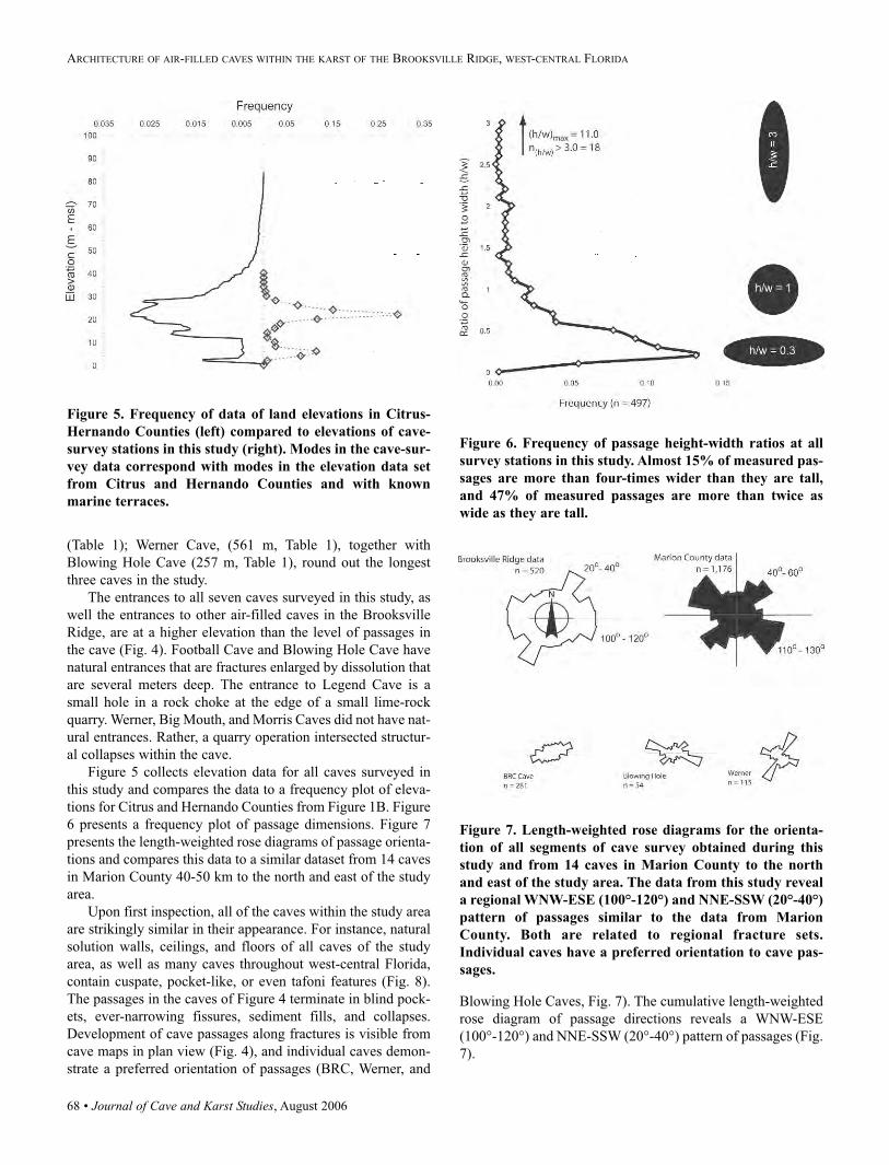
68 • Journal of Cave and Karst Studies, August 2006
ARCHITECTURE OF AIR-FILLED CAVES WITHIN THE KARST OF THE BROOKSVILLE RIDGE, WEST-CENTRAL FLORIDA
(Table 1); Werner Cave, (561 m, Table 1), together with
Blowing Hole Cave (257 m, Table 1), round out the longest
three caves in the study.
The entrances to all seven caves surveyed in this study, as
well the entrances to other air-filled caves in the Brooksville
Ridge, are at a higher elevation than the level of passages in
the cave (Fig. 4). Football Cave and Blowing Hole Cave have
natural entrances that are fractures enlarged by dissolution that
are several meters deep. The entrance to Legend Cave is a
small hole in a rock choke at the edge of a small lime-rock
quarry. Werner, Big Mouth, and Morris Caves did not have nat-
ural entrances. Rather, a quarry operation intersected structur-
al collapses within the cave.
Figure 5 collects elevation data for all caves surveyed in
this study and compares the data to a frequency plot of eleva-
tions for Citrus and Hernando Counties from Figure 1B. Figure
6 presents a frequency plot of passage dimensions. Figure 7
presents the length-weighted rose diagrams of passage orienta-
tions and compares this data to a similar dataset from 14 caves
in Marion County 40-50 km to the north and east of the study
area.
Upon first inspection, all of the caves within the study area
are strikingly similar in their appearance. For instance, natural
solution walls, ceilings, and floors of all caves of the study
area, as well as many caves throughout west-central Florida,
contain cuspate, pocket-like, or even tafoni features (Fig. 8).
The passages in the caves of Figure 4 terminate in blind pock-
ets, ever-narrowing fissures, sediment fills, and collapses.
Development of cave passages along fractures is visible from
cave maps in plan view (Fig. 4), and individual caves demon-
strate a preferred orientation of passages (BRC, Werner, and
Blowing Hole Caves, Fig. 7). The cumulative length-weighted
rose diagram of passage directions reveals a WNW-ESE
(100°-120°) and NNE-SSW (20°-40°) pattern of passages (Fig.
7).
Figure 5. Frequency of data of land elevations in Citrus-
Hernando Counties (left) compared to elevations of cave-
survey stations in this study (right). Modes in the cave-sur-
vey data correspond with modes in the elevation data set
from Citrus and Hernando Counties and with known
marine terraces.
Figure 6. Frequency of passage height-width ratios at all
survey stations in this study. Almost 15% of measured pas-
sages are more than four-times wider than they are tall,
and 47% of measured passages are more than twice as
wide as they are tall.
Figure 7. Length-weighted rose diagrams for the orienta-
tion of all segments of cave survey obtained during this
study and from 14 caves in Marion County to the north
and east of the study area. The data from this study reveal
a regional WNW-ESE (100°-120°) and NNE-SSW (20°-40°)
pattern of passages similar to the data from Marion
County. Both are related to regional fracture sets.
Individual caves have a preferred orientation to cave pas-
sages.
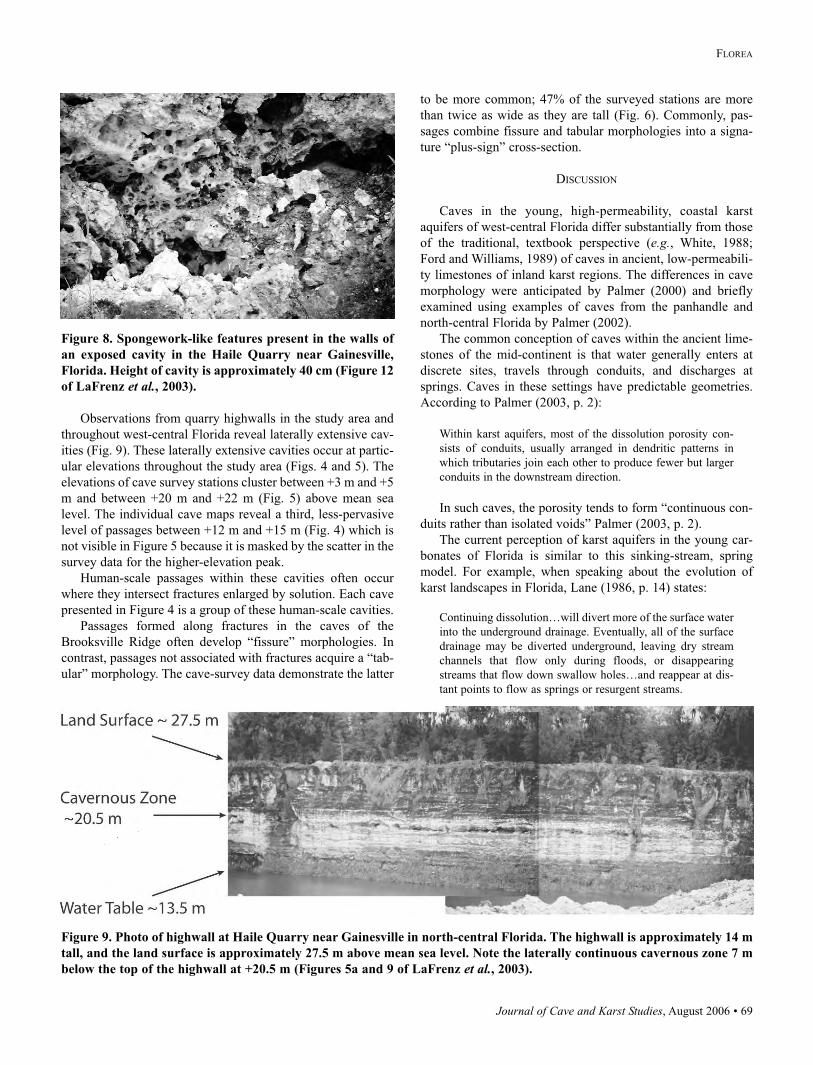
Journal of Cave and Karst Studies, August 2006 • 69
FLOREA
Observations from quarry highwalls in the study area and
throughout west-central Florida reveal laterally extensive cav-
ities (Fig. 9). These laterally extensive cavities occur at partic-
ular elevations throughout the study area (Figs. 4 and 5). The
elevations of cave survey stations cluster between +3 m and +5
m and between +20 m and +22 m (Fig. 5) above mean sea
level. The individual cave maps reveal a third, less-pervasive
level of passages between +12 m and +15 m (Fig. 4) which is
not visible in Figure 5 because it is masked by the scatter in the
survey data for the higher-elevation peak.
Human-scale passages within these cavities often occur
where they intersect fractures enlarged by solution. Each cave
presented in Figure 4 is a group of these human-scale cavities.
Passages formed along fractures in the caves of the
Brooksville Ridge often develop “fissure” morphologies. In
contrast, passages not associated with fractures acquire a “tab-
ular” morphology. The cave-survey data demonstrate the latter
to be more common; 47% of the surveyed stations are more
than twice as wide as they are tall (Fig. 6). Commonly, pas-
sages combine fissure and tabular morphologies into a signa-
ture “plus-sign” cross-section.
DISCUSSION
Caves in the young, high-permeability, coastal karst
aquifers of west-central Florida differ substantially from those
of the traditional, textbook perspective (e.g., White, 1988;
Ford and Williams, 1989) of caves in ancient, low-permeabili-
ty limestones of inland karst regions. The differences in cave
morphology were anticipated by Palmer (2000) and briefly
examined using examples of caves from the panhandle and
north-central Florida by Palmer (2002).
The common conception of caves within the ancient lime-
stones of the mid-continent is that water generally enters at
discrete sites, travels through conduits, and discharges at
springs. Caves in these settings have predictable geometries.
According to Palmer (2003, p. 2):
Within karst aquifers, most of the dissolution porosity con-
sists of conduits, usually arranged in dendritic patterns in
which tributaries join each other to produce fewer but larger
conduits in the downstream direction.
In such caves, the porosity tends to form “continuous con-
duits rather than isolated voids” Palmer (2003, p. 2).
The current perception of karst aquifers in the young car-
bonates of Florida is similar to this sinking-stream, spring
model. For example, when speaking about the evolution of
karst landscapes in Florida, Lane (1986, p. 14) states:
Continuing dissolution…will divert more of the surface water
into the underground drainage. Eventually, all of the surface
drainage may be diverted underground, leaving dry stream
channels that flow only during floods, or disappearing
streams that flow down swallow holes…and reappear at dis-
tant points to flow as springs or resurgent streams.
Figure 8. Spongework-like features present in the walls of
an exposed cavity in the Haile Quarry near Gainesville,
Florida. Height of cavity is approximately 40 cm (Figure 12
of LaFrenz et al., 2003).
Figure 9. Photo of highwall at Haile Quarry near Gainesville in north-central Florida. The highwall is approximately 14 m
tall, and the land surface is approximately 27.5 m above mean sea level. Note the laterally continuous cavernous zone 7 m
below the top of the highwall at +20.5 m (Figures 5a and 9 of LaFrenz et al., 2003).
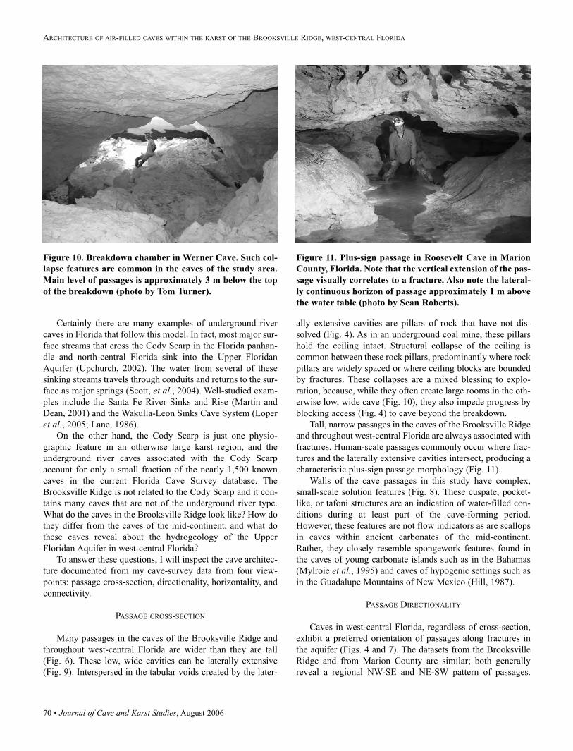
70 • Journal of Cave and Karst Studies, August 2006
ARCHITECTURE OF AIR-FILLED CAVES WITHIN THE KARST OF THE BROOKSVILLE RIDGE, WEST-CENTRAL FLORIDA
Certainly there are many examples of underground river
caves in Florida that follow this model. In fact, most major sur-
face streams that cross the Cody Scarp in the Florida panhan-
dle and north-central Florida sink into the Upper Floridan
Aquifer (Upchurch, 2002). The water from several of these
sinking streams travels through conduits and returns to the sur-
face as major springs (Scott, et al., 2004). Well-studied exam-
ples include the Santa Fe River Sinks and Rise (Martin and
Dean, 2001) and the Wakulla-Leon Sinks Cave System (Loper
et al., 2005; Lane, 1986).
On the other hand, the Cody Scarp is just one physio-
graphic feature in an otherwise large karst region, and the
underground river caves associated with the Cody Scarp
account for only a small fraction of the nearly 1,500 known
caves in the current Florida Cave Survey database. The
Brooksville Ridge is not related to the Cody Scarp and it con-
tains many caves that are not of the underground river type.
What do the caves in the Brooksville Ridge look like? How do
they differ from the caves of the mid-continent, and what do
these caves reveal about the hydrogeology of the Upper
Floridan Aquifer in west-central Florida?
To answer these questions, I will inspect the cave architec-
ture documented from my cave-survey data from four view-
points: passage cross-section, directionality, horizontality, and
connectivity.
PASSAGE CROSS-SECTION
Many passages in the caves of the Brooksville Ridge and
throughout west-central Florida are wider than they are tall
(Fig. 6). These low, wide cavities can be laterally extensive
(Fig. 9). Interspersed in the tabular voids created by the later-
ally extensive cavities are pillars of rock that have not dis-
solved (Fig. 4). As in an underground coal mine, these pillars
hold the ceiling intact. Structural collapse of the ceiling is
common between these rock pillars, predominantly where rock
pillars are widely spaced or where ceiling blocks are bounded
by fractures. These collapses are a mixed blessing to explo-
ration, because, while they often create large rooms in the oth-
erwise low, wide cave (Fig. 10), they also impede progress by
blocking access (Fig. 4) to cave beyond the breakdown.
Tall, narrow passages in the caves of the Brooksville Ridge
and throughout west-central Florida are always associated with
fractures. Human-scale passages commonly occur where frac-
tures and the laterally extensive cavities intersect, producing a
characteristic plus-sign passage morphology (Fig. 11).
Walls of the cave passages in this study have complex,
small-scale solution features (Fig. 8). These cuspate, pocket-
like, or tafoni structures are an indication of water-filled con-
ditions during at least part of the cave-forming period.
However, these features are not flow indicators as are scallops
in caves within ancient carbonates of the mid-continent.
Rather, they closely resemble spongework features found in
the caves of young carbonate islands such as in the Bahamas
(Mylroie et al., 1995) and caves of hypogenic settings such as
in the Guadalupe Mountains of New Mexico (Hill, 1987).
PASSAGE DIRECTIONALITY
Caves in west-central Florida, regardless of cross-section,
exhibit a preferred orientation of passages along fractures in
the aquifer (Figs. 4 and 7). The datasets from the Brooksville
Ridge and from Marion County are similar; both generally
reveal a regional NW-SE and NE-SW pattern of passages.
Figure 10. Breakdown chamber in Werner Cave. Such col-
lapse features are common in the caves of the study area.
Main level of passages is approximately 3 m below the top
of the breakdown (photo by Tom Turner).
Figure 11. Plus-sign passage in Roosevelt Cave in Marion
County, Florida. Note that the vertical extension of the pas-
sage visually correlates to a fracture. Also note the lateral-
ly continuous horizon of passage approximately 1 m above
the water table (photo by Sean Roberts).
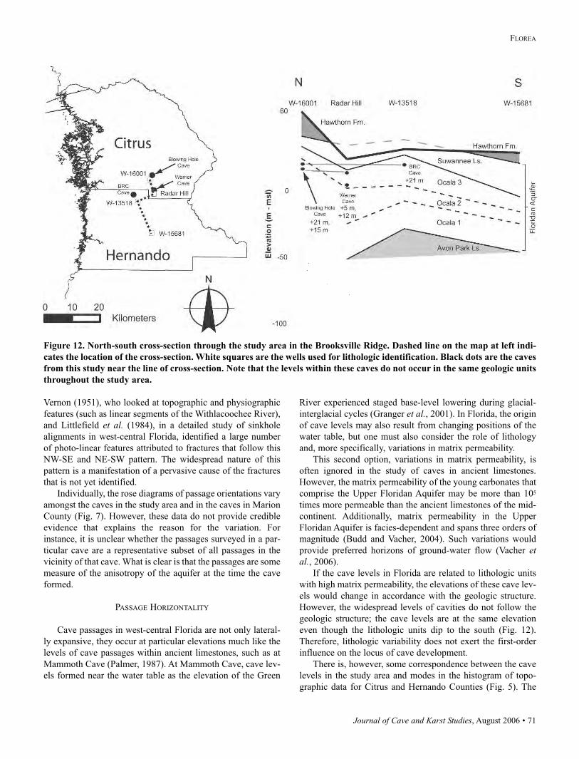
Journal of Cave and Karst Studies, August 2006 • 71
FLOREA
Vernon (1951), who looked at topographic and physiographic
features (such as linear segments of the Withlacoochee River),
and Littlefield et al. (1984), in a detailed study of sinkhole
alignments in west-central Florida, identified a large number
of photo-linear features attributed to fractures that follow this
NW-SE and NE-SW pattern. The widespread nature of this
pattern is a manifestation of a pervasive cause of the fractures
that is not yet identified.
Individually, the rose diagrams of passage orientations vary
amongst the caves in the study area and in the caves in Marion
County (Fig. 7). However, these data do not provide credible
evidence that explains the reason for the variation. For
instance, it is unclear whether the passages surveyed in a par-
ticular cave are a representative subset of all passages in the
vicinity of that cave. What is clear is that the passages are some
measure of the anisotropy of the aquifer at the time the cave
formed.
PASSAGE HORIZONTALITY
Cave passages in west-central Florida are not only lateral-
ly expansive, they occur at particular elevations much like the
levels of cave passages within ancient limestones, such as at
Mammoth Cave (Palmer, 1987). At Mammoth Cave, cave lev-
els formed near the water table as the elevation of the Green
River experienced staged base-level lowering during glacial-
interglacial cycles (Granger et al., 2001). In Florida, the origin
of cave levels may also result from changing positions of the
water table, but one must also consider the role of lithology
and, more specifically, variations in matrix permeability.
This second option, variations in matrix permeability, is
often ignored in the study of caves in ancient limestones.
However, the matrix permeability of the young carbonates that
comprise the Upper Floridan Aquifer may be more than 105
times more permeable than the ancient limestones of the mid-
continent. Additionally, matrix permeability in the Upper
Floridan Aquifer is facies-dependent and spans three orders of
magnitude (Budd and Vacher, 2004). Such variations would
provide preferred horizons of ground-water flow (Vacher etal., 2006).
If the cave levels in Florida are related to lithologic units
with high matrix permeability, the elevations of these cave lev-
els would change in accordance with the geologic structure.
However, the widespread levels of cavities do not follow the
geologic structure; the cave levels are at the same elevation
even though the lithologic units dip to the south (Fig. 12).
Therefore, lithologic variability does not exert the first-order
influence on the locus of cave development.
There is, however, some correspondence between the cave
levels in the study area and modes in the histogram of topo-
graphic data for Citrus and Hernando Counties (Fig. 5). The
Figure 12. North-south cross-section through the study area in the Brooksville Ridge. Dashed line on the map at left indi-
cates the location of the cross-section. White squares are the wells used for lithologic identification. Black dots are the caves
from this study near the line of cross-section. Note that the levels within these caves do not occur in the same geologic units
throughout the study area.
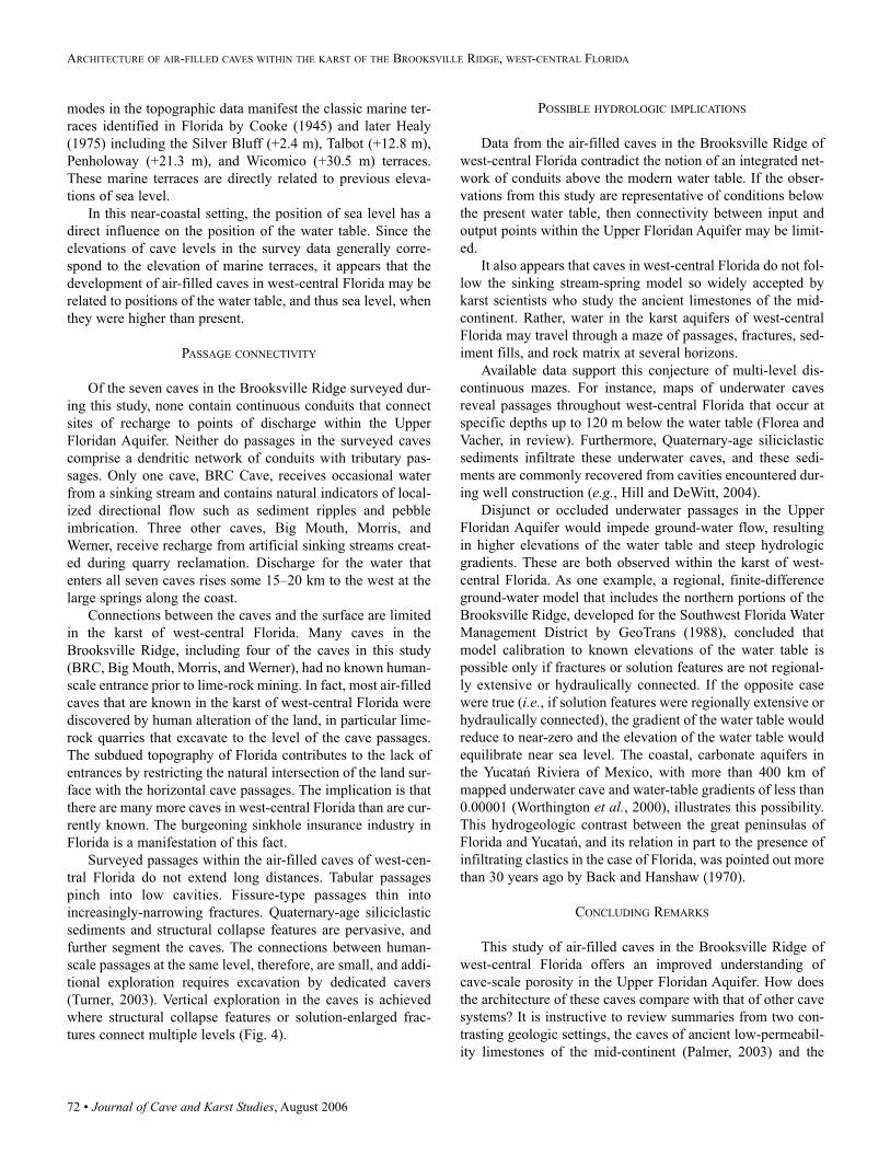
72 • Journal of Cave and Karst Studies, August 2006
ARCHITECTURE OF AIR-FILLED CAVES WITHIN THE KARST OF THE BROOKSVILLE RIDGE, WEST-CENTRAL FLORIDA
modes in the topographic data manifest the classic marine ter-
races identified in Florida by Cooke (1945) and later Healy
(1975) including the Silver Bluff (+2.4 m), Talbot (+12.8 m),
Penholoway (+21.3 m), and Wicomico (+30.5 m) terraces.
These marine terraces are directly related to previous eleva-
tions of sea level.
In this near-coastal setting, the position of sea level has a
direct influence on the position of the water table. Since the
elevations of cave levels in the survey data generally corre-
spond to the elevation of marine terraces, it appears that the
development of air-filled caves in west-central Florida may be
related to positions of the water table, and thus sea level, when
they were higher than present.
PASSAGE CONNECTIVITY
Of the seven caves in the Brooksville Ridge surveyed dur-
ing this study, none contain continuous conduits that connect
sites of recharge to points of discharge within the Upper
Floridan Aquifer. Neither do passages in the surveyed caves
comprise a dendritic network of conduits with tributary pas-
sages. Only one cave, BRC Cave, receives occasional water
from a sinking stream and contains natural indicators of local-
ized directional flow such as sediment ripples and pebble
imbrication. Three other caves, Big Mouth, Morris, and
Werner, receive recharge from artificial sinking streams creat-
ed during quarry reclamation. Discharge for the water that
enters all seven caves rises some 15–20 km to the west at the
large springs along the coast.
Connections between the caves and the surface are limited
in the karst of west-central Florida. Many caves in the
Brooksville Ridge, including four of the caves in this study
(BRC, Big Mouth, Morris, and Werner), had no known human-
scale entrance prior to lime-rock mining. In fact, most air-filled
caves that are known in the karst of west-central Florida were
discovered by human alteration of the land, in particular lime-
rock quarries that excavate to the level of the cave passages.
The subdued topography of Florida contributes to the lack of
entrances by restricting the natural intersection of the land sur-
face with the horizontal cave passages. The implication is that
there are many more caves in west-central Florida than are cur-
rently known. The burgeoning sinkhole insurance industry in
Florida is a manifestation of this fact.
Surveyed passages within the air-filled caves of west-cen-
tral Florida do not extend long distances. Tabular passages
pinch into low cavities. Fissure-type passages thin into
increasingly-narrowing fractures. Quaternary-age siliciclastic
sediments and structural collapse features are pervasive, and
further segment the caves. The connections between human-
scale passages at the same level, therefore, are small, and addi-
tional exploration requires excavation by dedicated cavers
(Turner, 2003). Vertical exploration in the caves is achieved
where structural collapse features or solution-enlarged frac-
tures connect multiple levels (Fig. 4).
POSSIBLE HYDROLOGIC IMPLICATIONS
Data from the air-filled caves in the Brooksville Ridge of
west-central Florida contradict the notion of an integrated net-
work of conduits above the modern water table. If the obser-
vations from this study are representative of conditions below
the present water table, then connectivity between input and
output points within the Upper Floridan Aquifer may be limit-
ed.
It also appears that caves in west-central Florida do not fol-
low the sinking stream-spring model so widely accepted by
karst scientists who study the ancient limestones of the mid-
continent. Rather, water in the karst aquifers of west-central
Florida may travel through a maze of passages, fractures, sed-
iment fills, and rock matrix at several horizons.
Available data support this conjecture of multi-level dis-
continuous mazes. For instance, maps of underwater caves
reveal passages throughout west-central Florida that occur at
specific depths up to 120 m below the water table (Florea and
Vacher, in review). Furthermore, Quaternary-age siliciclastic
sediments infiltrate these underwater caves, and these sedi-
ments are commonly recovered from cavities encountered dur-
ing well construction (e.g., Hill and DeWitt, 2004).
Disjunct or occluded underwater passages in the Upper
Floridan Aquifer would impede ground-water flow, resulting
in higher elevations of the water table and steep hydrologic
gradients. These are both observed within the karst of west-
central Florida. As one example, a regional, finite-difference
ground-water model that includes the northern portions of the
Brooksville Ridge, developed for the Southwest Florida Water
Management District by GeoTrans (1988), concluded that
model calibration to known elevations of the water table is
possible only if fractures or solution features are not regional-
ly extensive or hydraulically connected. If the opposite case
were true (i.e., if solution features were regionally extensive or
hydraulically connected), the gradient of the water table would
reduce to near-zero and the elevation of the water table would
equilibrate near sea level. The coastal, carbonate aquifers in
the Yucatań Riviera of Mexico, with more than 400 km of
mapped underwater cave and water-table gradients of less than
0.00001 (Worthington et al., 2000), illustrates this possibility.
This hydrogeologic contrast between the great peninsulas of
Florida and Yucatań, and its relation in part to the presence of
infiltrating clastics in the case of Florida, was pointed out more
than 30 years ago by Back and Hanshaw (1970).
CONCLUDING REMARKS
This study of air-filled caves in the Brooksville Ridge of
west-central Florida offers an improved understanding of
cave-scale porosity in the Upper Floridan Aquifer. How does
the architecture of these caves compare with that of other cave
systems? It is instructive to review summaries from two con-
trasting geologic settings, the caves of ancient low-permeabil-
ity limestones of the mid-continent (Palmer, 2003) and the
Journal of Cave and Karst Studies, August 2006 • 73
FLOREA
caves of small islands composed of Pleistocene limestone
(Mylroie et al., 1995).
The first example, the caves of the mid-continent, is impor-
tant because it is the paradigm view of near-surface caves.
Palmer (2003, p. 2) uses the following description for such
caves:
Most accessible caves are surrounded by rock in which the
vast majority of openings have hardly enlarged at all. The
conduits are not surrounded by porous zones, with walls like
a sponge, where progressively smaller openings extend indef-
initely into the cave wall. The conduits are quite discrete.
Cave passages in the young carbonates of west-central
Florida do not fit this description. Tabular passages are lateral-
ly extensive, and fissure-type passages thin into increasingly-
narrowing fractures; both extend beyond the limits of human
exploration. The walls of the passages are porous and complex,
with small-scale solution features such as pockets and tafoni
structures extending into the host bedrock, which itself has
high permeability. Cave passages in the Brooksville Ridge are
not discrete conduits, and they do not connect together into a
dendritic-style drainage system as described by Palmer (1991).
Ground water in the Upper Floridan Aquifer may readily
exchange between the cave and the rock matrix (Martin and
Dean, 2001).
The second example, from the young carbonate islands, is
important because it is the paradigm for caves in young lime-
stone. These flank margin caves, which form by mixing at the
water table and at the freshwater-saltwater interface, are sum-
marized as follows by Mylroie and Carew (1995, p. 252-253):
Typically these caves are dominated by large globular cham-
bers that are broad in the horizontal plane but vertically
restricted…At the rear of the chamber there is usually a series
of smaller chambers that change into tubular
passages…Commonly there are many cross-connections
between adjacent chambers and passages that give the caves
a maze-like character. The passages…end abruptly. The
chamber and passage walls are often etched into a variety of
dissolution pockets and tubes…Flow markings, such as abla-
tion scallops, are absent.
Many of the features found in the caves of the Brooksville
Ridge are remarkably similar to this description. Laterally
extensive cavities contain bedrock pillars and cuspate dissolu-
tion features, and the passages often terminate in blind pock-
ets. Flow indicators are generally not present. However, there
are distinct differences between caves of west-central Florida
and caves on young, carbonate islands. Whereas flank margin
caves, for example, are composed of amorphous voids and
rudimentary, spongework mazes (Palmer, 1991), the caves in
west-central Florida contain passages with a sense of direc-
tionality imposed by fractures in the rock matrix. The result is
maps that resemble network maze caves in plan view, such as
those in the Black Hills of South Dakota (Palmer, 1991).
In conclusion, caves in west-central Florida do not fit exist-
ing models of cave architecture. They represent a style of cav-
ern development important within coastal karst aquifers com-
posed of young carbonates.
These west-central-Florida caves that lie above the water
table demonstrate the extreme heterogeneity of permeability
within the unconfined Upper Floridan Aquifer that lies below.
This study offers the following insights to the architecture of
cave-scale porosity in this critical-use aquifer: 1) cave-scale
porosity is widespread but often composed of isolated or par-
tially connected passages; 2) cave passages are generally
restricted to specific elevations within the aquifer framework,
and 3) the direction of cave passages in these levels occurs
along a NE-SW and NW-SE system of fractures.
ACKNOWLEDGMENTS
This project is indebted to the hard work of cavers and cave
surveyors in Florida. I extend personal gratitude to members of
the Florida Cave Survey, the Florida Speleological Society, the
Tampa Bay Area Grotto, and the Withlacoochee State Forest –
in particular Robert Brooks, Sean Roberts, Dan Straley, Tom
Turner, Bill Walker, and Colleen Werner – for their assistance
and cooperation during this project. I also thank other mem-
bers of the Karst Research Group at the University of South
Florida for their time, field assistance and ideas. Funding for
this and other related work is provided by monetary and equip-
ment grants from the Geological Society of America, Gulf
Coast Association of Geological Sciences, Society for
Sedimentary Petrology, National Speleological Society,
Southwest Florida Water Management District, and the Florida
Studies Center. Two anonymous reviewers helped to guide the
presentation of data and ideas.
REFERENCES
Back, W., and Hanshaw, B.B., 1970, Comparison of chemical
hydrology of the carbonate peninsulas of Florida and
Yucatan: Journal of Hydrology, v. 10, pp. 330–368.
Brinkmann, R., and Reeder, P., 1994, The influence of sea-
level change and geologic structure on cave development
in west-central Florida: Physical Geography, v. 15, p.
52–61.
Budd, D.A., and Vacher, H.L., 2004, Matrix permeability of
the confined Floridan Aquifer: Hydrogeology Journal, v.
12, no. 5, 531–549.
Cooke, C.W., 1945, Geology of Florida: Florida Geological
Survey Bulletin 29, 339 p.
Florea, L.J., and Vacher, H.L., in review, Quaternary cave lev-
els in peninsular Florida: Quaternary Science Reviews.
Ford, D.C., and Williams, P.W., 1989, Karst geomorphology
and hydrology, Unwin Hyman, London, 601 p.
GeoTrans, 1988, Hydrologic investigation of the northern por-
tion of the Southwest Florida Water Management District,
northern district model project, phase II final report: 151 p.
74 • Journal of Cave and Karst Studies, August 2006
ARCHITECTURE OF AIR-FILLED CAVES WITHIN THE KARST OF THE BROOKSVILLE RIDGE, WEST-CENTRAL FLORIDA
Granger, D.E., Fabel, D., and Palmer, A.N., 2001, Plio-
Pleistocene incision of the Green River, Kentucky deter-
mined from the radioactive decay of cosmogenic 26Al and10Be in Mammoth Cave sediments: GSA bulletin, v. 113,
no. 7, p. 825–836.
Healy, H.G., 1975, Terraces and Shorelines of Florida: Florida
Bureau of Geology Map Series 71.
Hill, M.E., and DeWitt, D.J., 2004, Drilling and Testing Report
for the ROMP WW-2 and WW-3 Monitoring Well Sites,
Hernando County, Florida: Southwest Florida Water
Management District, 12 p.
Hill, C.A., 1987, Geology of Carlsbad Caverns and other caves
in the Guadalupe Mountains, New Mexico: New Mexico
Bureau of Mines and Mineral Resources Bulletin 117, 150
p.
LaFrenz, W.B., Bulmer, W.H., Jamilla, S.V., and O’Neal-
Caldwell, M., 2003, Characteristics and development of
shallow solution features in thinly mantled karst, Alachua
and Levy Counties, Florida: In Florea, L., Vacher, H.L.,
and Oches, E.A., eds. Karst Studies in West Central
Florida: USF Seminar in Karst Environments, Southwest
Florida Water Management District, p. 21–37.
Lane, E., 1986, Karst in Florida: Florida Geological Survey
Special Publication no. 29, 100 p.
Littlefield, J.R., Culbreth, M.A., Upchurch, S.B., and Stewart,
M.T., 1984, Relationship of Modern Sinkhole
Development to Large-Scale Photolinear Features: In 1st
Multidisciplinary Conference on Sinkholes, Beck, B.F.,
ed., p. 189–195.
Loizeaux, N.T., 1995, Lithologic and hydrogeologic frame-
work for a carbonate aquifer: evidence for facies-con-
trolled hydraulic conductivity in the Ocala Formation,
West-Central Florida: [MS Thesis] University of Colorado,
Boulder, Colorado, 125 p.
Loper, D.E., Werner, C.L., Chicken, E., Davies, G., and
Kincaid, T., 2005, Coastal carbonate aquifer sensitivity to
tides: EOS Transactions, American Geophysical Union, v.
86, no. 39, p. 353, 357.
Martin, J.B., and Dean, R.W., 2001, Exchange of water
between conduits and matrix in the Floridan aquifer:
Chemical Geology, vol. 179, p. 145–165.
Meinzer, O.E., 1927, Large springs in the United States:
United States Geological Survey Water Supply Paper 557,
United States Geological Survey.
Miller, J.A., 1986, Hydrogeologic Framework of the Floridan
Aquifer System in Florida and in Parts of Georgia,
Alabama, and South Carolina: United States Geological
Survey Professional Paper 1403-B, 91p.
Mylroie, J.E., Carew, J.L., and Vacher, H.L., 1995, Karst
development in the Bahamas and Bermuda: In Curran,
H.A. and White, B., eds. Terrestrial and shallow marine
geology of the Bahamas and Bermuda, Geological Society
of America Special Paper, Boulder, Colorado, v. 300, p.
251–267.
Palmer A.N., 2003, Patterns of dissolution and porosity in car-
bonate rocks: Speleogenesis and Evolution of Karst
Aquifers, v. 1, p. 1–9.
Palmer, A.N., 2002, Karst in Paleozoic rocks: How does it dif-
fer from Florida? In Hydrogeology and Biology of Post
Paleozoic Karst Aquifers, Martin, J.B., Wicks, C.M., and
Sasowsky, I.D., eds., Karst Frontiers, Proceedings of the
Karst Waters Institute Symposium, p. 185–191.
Palmer A.N., 2000, Hydrogeologic control of cave patterns: InKlimchouk, A., Ford, D., Palmer, A., and Dreybrodt, W.,
eds. Speleogenesis: evolution of karst aquifers, National
Speleological Society, p. 77–90.
Palmer, A.N., 1991, Origin and morphology of limestone
caves: Geological Society of America Bulletin, v. 103, p.
1–21.
Palmer, A.N., 1987, Cave levels and their interpretation:
National Speleological Society Bulletin, v. 49, p. 50–66.
Rosenau, J.C., Faulkner, G.L., Hendry Jr., C.W., and Hull,
R.W., 1977, Springs of Florida, Florida Geological Survey
Bulletin 31 (Revised).
Scott, T.M., Campbell, K.M., Rupert, F.R., Arthur, J.A.,
Missimer, T.M., Lloyd, J.M., Yon, J.W., and Duncan, J.G.,
2001, Geologic map of the State of Florida: Florida
Geological Survey Map Series 146.
Scott, T.M., 1988, The Lithostratigraphy of the Hawthorn
Group (Miocene) of Florida: Florida Geological Survey
Bulletin 59, 148 p.
Scott, T.M., Means, G.H., Meegan, R.P., Means R.C.,
Upchurch, S.B., Copeland, R.E., Jones, J., Roberts, and T.,
Willet, A., 2004, Springs of Florida, Florida Geological
Survey Bulletin 66, 377 p.
Stringfield V.T., and LeGrand, H.E., 1966, Hydrology of
Limestone Terranes in the Coastal Plain of the
Southeastern United States: Geological Society of America
Special Paper 93, 41 p.
Tihansky, A.B., 1999, Sinkholes, West-Central Florida: InLand Subsidence in the United States, Galloway D., Jones,
D.R., and Ingebritsen S.E, eds., United States Geological
Survey Circular 1182, 177 p.
Turner, T., 2003, Brooksville Ridge Cave: Florida’s Hidden
Treasure: NSS News, May 2003, p. 125–131, 143.
Upchurch S.B., 2002, Hydrogeochemistry of a karst escarp-
ment: In Hydrogeology and Biology of Post Paleozoic
Karst Aquifers, Martin, J.B., Wicks, C.M., and Sasowsky,
I.D., eds., Karst Frontiers, Proceedings of the Karst Waters
Institute Symposium, p. 73–75.
Vacher, H.L., Hutchings, W.C., and Budd, D.A., 2006,
Metaphors and Models: The ASR Bubble in the Floridan
Aquifer: Ground Water, v. 44, n. 2, p. 144–152.
Vernon, R.O., 1951, Geology of Citrus and Levy Counties,
Florida: Florida Geological Survey Bulletin 33.
White, W.A., 1970, The Geomorphology of the Floridan
Peninsula: Florida Bureau of Geology Bulletin 51.
White, W.B., 1988, Geomorphology and Hydrology of Karst
Terrains, Oxford University Press, New York, 464 p.

Journal of Cave and Karst Studies, August 2006 • 75
FLOREA
Worthington, S.R.H., Ford, D.C., and Beddows, P.A., 2000,
Porosity and permeability enhancement in unconfined car-
bonate aquifers as a result of solution. In Klimchouk, A.,
Ford, D., Palmer, A., and Dreybrodt, W., eds.
Speleogenesis: Evolution of karst aquifers, National
Speleological Society, p. 463–472.
Yon, J.W., and Hendry, C.W., 1972, Suwannee Limestone in
Hernando and Pasco counties, Florida; part I: Florida
Bureau of Geology Bulletin 54, p.1–42.
Yon, J.W., Waite, W.R., and Williams, C.T., 1989, Part II –
Geology, Mining, and Reclamation at the Radar Hill
Quarry, Citrus County, Florida: Florida Geological Survey
Information Circular 105, p. 36–51.
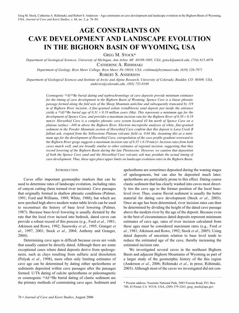
76 • Journal of Cave and Karst Studies, August 2006
Greg M. Stock, Catherine A. Riihimaki, and Robert S. Anderson – Age constraints on cave development and landscape evolution in the Bighorn Basin of Wyoming,
USA. Journal of Cave and Karst Studies, v. 68, no. 2, p. 76–84.
INTRODUCTION
Caves offer important geomorphic markers that can be
used to determine rates of landscape evolution, including rates
of canyon cutting (here termed river incision). Cave passages
that originally formed in shallow phreatic conditions (Palmer,
1991; Ford and Williams, 1989; White, 1988), but which are
now perched high above modern water-table levels can be used
to reconstruct the history of base level lowering (Palmer,
1987). Because base-level lowering is usually dictated by the
rate that the local river incised into bedrock, dated caves can
provide a robust record of this process (e.g., Ford et al., 1981;
Atkinson and Rowe, 1992; Sasowsky et al., 1995; Granger etal., 1997, 2001; Stock et al., 2004; Anthony and Granger,
2004).
Determining cave ages is difficult because caves are voids
that usually cannot be directly dated. Although there are some
exceptional cases where dated deposits derive from speleoge-
nesis, such as clays resulting from sulfuric acid dissolution
(Polyak et al., 1998), more often only limiting estimates of
cave age can be determined by dating either speleothems or
sediments deposited within cave passages after the passages
formed. U/Th dating of calcite speleothems or paleomagnetic
or cosmogenic 26Al/10Be burial dating of clastic sediment are
the primary methods of constraining cave ages. Sediment and
speleothems are sometimes deposited during the waning stages
of speleogenesis, but can also be deposited much later;
speleothems are particularly prone to this effect. Dating coarse
clastic sediment that has clearly washed into caves most direct-
ly ties the cave age to the former position of the local base-
level river. Thus, coarse fluvial sediment is usually the better
material for dating cave development (Stock et al., 2005).
Once an age has been determined, river incision rates can then
be determined by dividing the height of the dated cave passage
above the modern river by the age of the deposit. Because even
in the best of circumstances dated deposits represent minimum
estimates of cave age, rates of river incision calculated from
these ages must be considered maximum rates (e.g., Ford etal., 1981; Atkinson and Rowe, 1992; Stock et al., 2005). Using
dated deposits of uncertain relation to base level tends to
reduce the estimated age of the cave, thereby increasing the
estimated incision rate.
We investigated several caves in the northeast Bighorn
Basin and adjacent Bighorn Mountains of Wyoming as part of
a larger study of the geomorphic history of the this region
(Anderson et al., 2006; Riihimaki et al., in press; Riihimaki,
2003). Although most of the caves we investigated did not con-
AGE CONSTRAINTS ON
CAVE DEVELOPMENT AND LANDSCAPE EVOLUTION
IN THE BIGHORN BASIN OF WYOMING, USAGREG M. STOCK*
Department of Geological Sciences, University of Michigan, Ann Arbor, MI 48109-1005, USA, [email protected], (734) 615-4076CATHERINE A. RIIHIMAKI
Department of Geology, Bryn Mawr College, Bryn Mawr, PA 19010, USA, [email protected], (610) 526-7971ROBERT S. ANDERSON
Department of Geological Sciences and Institute of Arctic and Alpine Research, University of Colorado, Boulder, CO 80309, USA,[email protected], (303) 735-8169
Cosmogenic 26Al/10Be burial dating and tephrochronology of cave deposits provide minimum estimatesfor the timing of cave development in the Bighorn Basin of Wyoming. Spence Cave is a linear phreaticpassage formed along the fold axis of the Sheep Mountain anticline and subsequently truncated by 119m of Bighorn River incision. A fine-grained eolian (windblown) sand deposit just inside the entranceyields a 26Al/10Be burial age of 0.31 ± 0.19 million years (Ma). This represents a minimum age for thedevelopment of Spence Cave, and provides a maximum incision rate for the Bighorn River of 0.38 ± 0.19mm/yr. Horsethief Cave is a complex phreatic cave system located 43 km north of Spence Cave on aplateau surface ~340 m above the Bighorn River. Electron microprobe analyses of white, fine-grainedsediment in the Powder Mountain section of Horsethief Cave confirm that this deposit is Lava Creek Bfallout ash, erupted from the Yellowstone Plateau volcanic field ca. 0.64 Ma. Assuming this as a mini-mum age for the development of Horsethief Cave, extrapolation of the cave profile gradient westward tothe Bighorn River gorge suggests a maximum incision rate of 0.35 ± 0.19 mm/yr. Incision rates from bothcaves match well, and are broadly similar to other estimates of regional incision, suggesting that theyrecord lowering of the Bighorn Basin during the late Pleistocene. However, we caution that depositionof both the Spence Cave sand and the Horsethief Cave volcanic ash may postdate the actual timing ofcave development. Thus, these ages place upper limits on landscape evolution rates in the Bighorn Basin.
* Present address: Yosemite National Park, 5083 Foresta Road, P.O. Box
700, El Portal, CA 95318, USA, (209) 379-3263, [email protected]
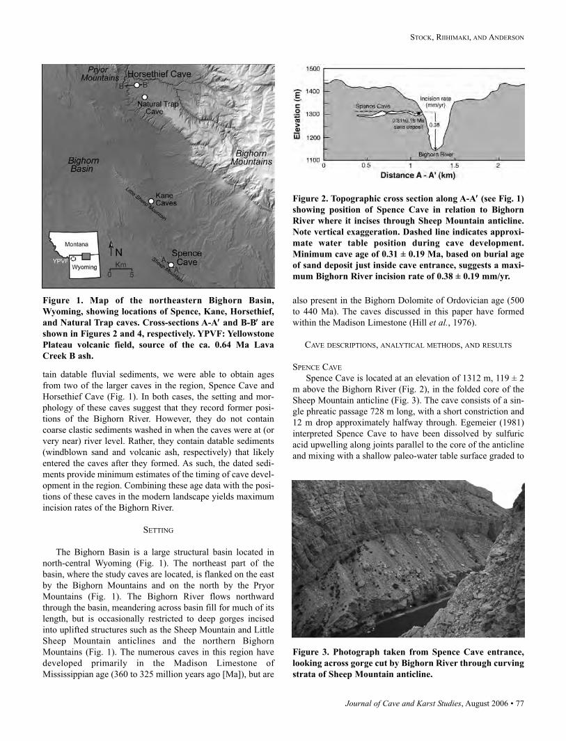
Journal of Cave and Karst Studies, August 2006 • 77
STOCK, RIIHIMAKI, AND ANDERSON
tain datable fluvial sediments, we were able to obtain ages
from two of the larger caves in the region, Spence Cave and
Horsethief Cave (Fig. 1). In both cases, the setting and mor-
phology of these caves suggest that they record former posi-
tions of the Bighorn River. However, they do not contain
coarse clastic sediments washed in when the caves were at (or
very near) river level. Rather, they contain datable sediments
(windblown sand and volcanic ash, respectively) that likely
entered the caves after they formed. As such, the dated sedi-
ments provide minimum estimates of the timing of cave devel-
opment in the region. Combining these age data with the posi-
tions of these caves in the modern landscape yields maximum
incision rates of the Bighorn River.
SETTING
The Bighorn Basin is a large structural basin located in
north-central Wyoming (Fig. 1). The northeast part of the
basin, where the study caves are located, is flanked on the east
by the Bighorn Mountains and on the north by the Pryor
Mountains (Fig. 1). The Bighorn River flows northward
through the basin, meandering across basin fill for much of its
length, but is occasionally restricted to deep gorges incised
into uplifted structures such as the Sheep Mountain and Little
Sheep Mountain anticlines and the northern Bighorn
Mountains (Fig. 1). The numerous caves in this region have
developed primarily in the Madison Limestone of
Mississippian age (360 to 325 million years ago [Ma]), but are
also present in the Bighorn Dolomite of Ordovician age (500
to 440 Ma). The caves discussed in this paper have formed
within the Madison Limestone (Hill et al., 1976).
CAVE DESCRIPTIONS, ANALYTICAL METHODS, AND RESULTS
SPENCE CAVE
Spence Cave is located at an elevation of 1312 m, 119 ± 2
m above the Bighorn River (Fig. 2), in the folded core of the
Sheep Mountain anticline (Fig. 3). The cave consists of a sin-
gle phreatic passage 728 m long, with a short constriction and
12 m drop approximately halfway through. Egemeier (1981)
interpreted Spence Cave to have been dissolved by sulfuric
acid upwelling along joints parallel to the core of the anticline
and mixing with a shallow paleo-water table surface graded to
Figure 1. Map of the northeastern Bighorn Basin,
Wyoming, showing locations of Spence, Kane, Horsethief,
and Natural Trap caves. Cross-sections A-A′′ and B-B′′ are
shown in Figures 2 and 4, respectively. YPVF: Yellowstone
Plateau volcanic field, source of the ca. 0.64 Ma Lava
Creek B ash.
Figure 2. Topographic cross section along A-A′′ (see Fig. 1)
showing position of Spence Cave in relation to Bighorn
River where it incises through Sheep Mountain anticline.
Note vertical exaggeration. Dashed line indicates approxi-
mate water table position during cave development.
Minimum cave age of 0.31 ± 0.19 Ma, based on burial age
of sand deposit just inside cave entrance, suggests a maxi-
mum Bighorn River incision rate of 0.38 ± 0.19 mm/yr.
Figure 3. Photograph taken from Spence Cave entrance,
looking across gorge cut by Bighorn River through curving
strata of Sheep Mountain anticline.
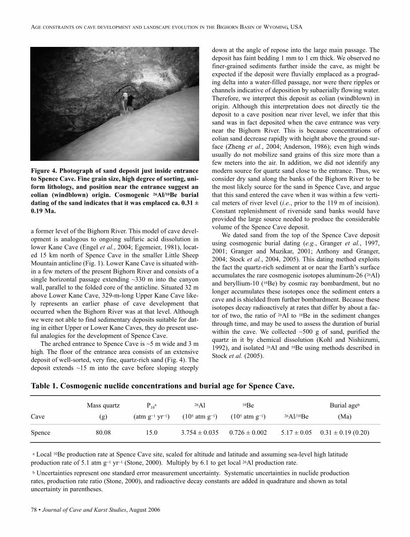
78 • Journal of Cave and Karst Studies, August 2006
AGE CONSTRAINTS ON CAVE DEVELOPMENT AND LANDSCAPE EVOLUTION IN THE BIGHORN BASIN OF WYOMING, USA
a former level of the Bighorn River. This model of cave devel-
opment is analogous to ongoing sulfuric acid dissolution in
lower Kane Cave (Engel et al., 2004; Egemeier, 1981), locat-
ed 15 km north of Spence Cave in the smaller Little Sheep
Mountain anticline (Fig. 1). Lower Kane Cave is situated with-
in a few meters of the present Bighorn River and consists of a
single horizontal passage extending ~330 m into the canyon
wall, parallel to the folded core of the anticline. Situated 32 m
above Lower Kane Cave, 329-m-long Upper Kane Cave like-
ly represents an earlier phase of cave development that
occurred when the Bighorn River was at that level. Although
we were not able to find sedimentary deposits suitable for dat-
ing in either Upper or Lower Kane Caves, they do present use-
ful analogies for the development of Spence Cave.
The arched entrance to Spence Cave is ~5 m wide and 3 m
high. The floor of the entrance area consists of an extensive
deposit of well-sorted, very fine, quartz-rich sand (Fig. 4). The
deposit extends ~15 m into the cave before sloping steeply
down at the angle of repose into the large main passage. The
deposit has faint bedding 1 mm to 1 cm thick. We observed no
finer-grained sediments further inside the cave, as might be
expected if the deposit were fluvially emplaced as a prograd-
ing delta into a water-filled passage, nor were there ripples or
channels indicative of deposition by subaerially flowing water.
Therefore, we interpret this deposit as eolian (windblown) in
origin. Although this interpretation does not directly tie the
deposit to a cave position near river level, we infer that this
sand was in fact deposited when the cave entrance was very
near the Bighorn River. This is because concentrations of
eolian sand decrease rapidly with height above the ground sur-
face (Zheng et al., 2004; Anderson, 1986); even high winds
usually do not mobilize sand grains of this size more than a
few meters into the air. In addition, we did not identify any
modern source for quartz sand close to the entrance. Thus, we
consider dry sand along the banks of the Bighorn River to be
the most likely source for the sand in Spence Cave, and argue
that this sand entered the cave when it was within a few verti-
cal meters of river level (i.e., prior to the 119 m of incision).
Constant replenishment of riverside sand banks would have
provided the large source needed to produce the considerable
volume of the Spence Cave deposit.
We dated sand from the top of the Spence Cave deposit
using cosmogenic burial dating (e.g., Granger et al., 1997,
2001; Granger and Muzikar, 2001; Anthony and Granger,
2004; Stock et al., 2004, 2005). This dating method exploits
the fact the quartz-rich sediment at or near the Earth’s surface
accumulates the rare cosmogenic isotopes aluminum-26 (26Al)
and beryllium-10 (10Be) by cosmic ray bombardment, but no
longer accumulates these isotopes once the sediment enters a
cave and is shielded from further bombardment. Because these
isotopes decay radioactively at rates that differ by about a fac-
tor of two, the ratio of 26Al to 10Be in the sediment changes
through time, and may be used to assess the duration of burial
within the cave. We collected ~500 g of sand, purified the
quartz in it by chemical dissolution (Kohl and Nishiizumi,
1992), and isolated 26Al and 10Be using methods described in
Stock et al. (2005).
Figure 4. Photograph of sand deposit just inside entrance
to Spence Cave. Fine grain size, high degree of sorting, uni-
form lithology, and position near the entrance suggest an
eolian (windblown) origin. Cosmogenic 26Al/10Be burial
dating of the sand indicates that it was emplaced ca. 0.31 ±
0.19 Ma.
Table 1. Cosmogenic nuclide concentrations and burial age for Spence Cave.
Mass quartz P10a 26Al 10Be Burial ageb
Cave (g) (atm g–1 yr–1) (105 atm g–1) (105 atm g–1) 26Al/10Be (Ma)
Spence 80.08 15.0 3.754 ± 0.035 0.726 ± 0.002 5.17 ± 0.05 0.31 ± 0.19 (0.20)
a Local 10Be production rate at Spence Cave site, scaled for altitude and latitude and assuming sea-level high latitude
production rate of 5.1 atm g–1 yr–1 (Stone, 2000). Multiply by 6.1 to get local 26Al production rate.
b Uncertainties represent one standard error measurement uncertainty. Systematic uncertainties in nuclide production
rates, production rate ratio (Stone, 2000), and radioactive decay constants are added in quadrature and shown as total
uncertainty in parentheses.
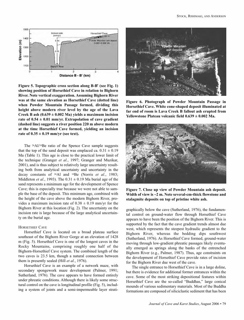
Journal of Cave and Karst Studies, August 2006 • 79
STOCK, RIIHIMAKI, AND ANDERSON
The 26Al/10Be ratio of the Spence Cave sample suggests
that the top of the sand deposit was emplaced ca. 0.31 ± 0.19
Ma (Table 1). This age is close to the practical lower limit of
the technique (Granger et al., 1997; Granger and Muzikar,
2001), and is thus subject to relatively large uncertainty result-
ing both from analytical uncertainty and uncertainty in the
decay constants of 26Al and 10Be (Norris et al., 1983;
Middleton et al., 1993). The 0.31 ± 0.19 Ma burial age of the
sand represents a minimum age for the development of Spence
Cave; this is especially true because we were not able to sam-
ple the base of the deposit. This minimum age, combined with
the height of the cave above the modern Bighorn River, pro-
vides a maximum incision rate of 0.38 ± 0.19 mm/yr for the
Bighorn River at this location (Fig. 2). The uncertainty on the
incision rate is large because of the large analytical uncertain-
ty on the burial age.
HORSETHIEF CAVE
Horsethief Cave is located on a broad plateau surface
southeast of the Bighorn River Gorge at an elevation of 1428
m (Fig. 5). Horsethief Cave is one of the longest caves in the
Rocky Mountains, comprising roughly one half of the
Bighorn-Horsethief Cave system. The combined length of the
two caves is 23.5 km, though a natural connection between
them is presently sealed (Hill et al., 1976).
Horsethief Cave is an example of a network maze, with
secondary spongework maze development (Palmer, 1991;
Sutherland, 1976). The cave appears to have formed entirely
under phreatic conditions. Although there is likely some struc-
tural control on the cave is longitudinal profile (Fig. 5), includ-
ing a system of joints and a semi-impermeable layer strati-
graphically below the cave (Sutherland, 1976), the fundamen-
tal control on ground-water flow through Horsethief Cave
appears to have been the position of the Bighorn River. This is
supported by the fact that the cave gradient trends almost due
west, which represents the steepest hydraulic gradient to the
Bighorn River, whereas the bedding dips southwest
(Sutherland, 1976). As Horsethief Cave formed, ground-water
moving through low-gradient phreatic passages likely eventu-
ally emerged as springs along the banks of the entrenched
Bighorn River (e.g., Palmer, 1987). Thus, age constraints on
the development of Horsethief Cave provide rates of incision
for the Bighorn River due west of the cave.
The single entrance to Horsethief Cave is in a large doline,
but there is evidence for additional former entrances within the
cave. Some of the most striking depositional features within
Horsethief Cave are the so-called “Buddhas,” large conical
mounds of various sedimentary materials. Most of the Buddha
formations are composed of siliciclastic sediment that has been
Figure 5. Topographic cross section along B-B′′ (see Fig. 1)
showing position of Horsethief Cave in relation to Bighorn
River. Note vertical exaggeration. Assuming Bighorn River
was at the same elevation as Horsethief Cave (dotted line)
when Powder Mountain Passage formed, dividing this
height above modern river level by the age of the Lava
Creek B ash (0.639 ± 0.002 Ma) yields a maximum incision
rate of 0.54 ± 0.01 mm/yr. Extrapolation of cave gradient
(dashed line) suggests a river position 220 m above modern
at the time Horsethief Cave formed, yielding an incision
rate of 0.35 ± 0.19 mm/yr (see text).
Figure 6. Photograph of Powder Mountain Passage in
Horsethief Cave. White cone-shaped deposit illuminated at
far end of room is Lava Creek B fallout ash erupted from
Yellowstone Plateau volcanic field 0.639 ± 0.002 Ma.
Figure 7. Close up view of Powder Mountain ash deposit.
Width of view is ~2 m. Note several-cm-thick flowstone and
stalagmite deposits on top of pristine white ash.
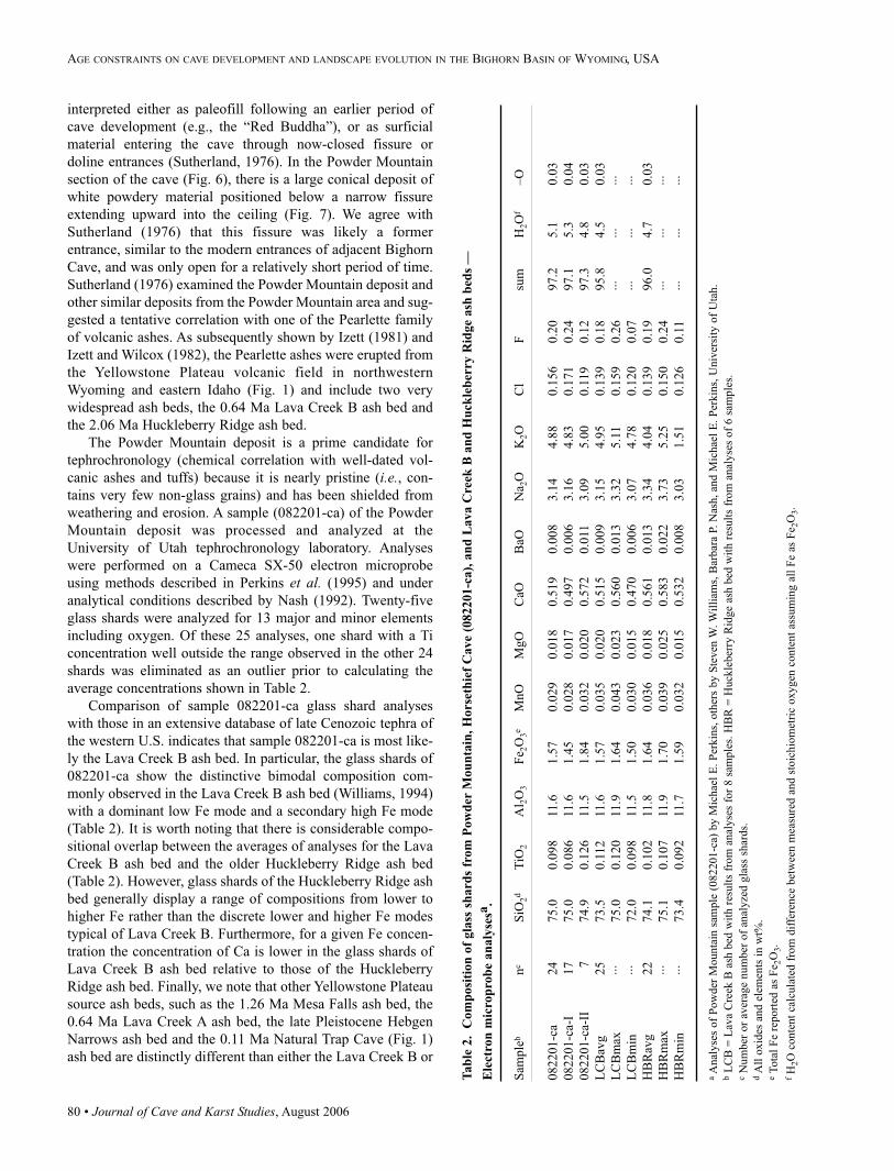
80 • Journal of Cave and Karst Studies, August 2006
AGE CONSTRAINTS ON CAVE DEVELOPMENT AND LANDSCAPE EVOLUTION IN THE BIGHORN BASIN OF WYOMING, USA
interpreted either as paleofill following an earlier period of
cave development (e.g., the “Red Buddha”), or as surficial
material entering the cave through now-closed fissure or
doline entrances (Sutherland, 1976). In the Powder Mountain
section of the cave (Fig. 6), there is a large conical deposit of
white powdery material positioned below a narrow fissure
extending upward into the ceiling (Fig. 7). We agree with
Sutherland (1976) that this fissure was likely a former
entrance, similar to the modern entrances of adjacent Bighorn
Cave, and was only open for a relatively short period of time.
Sutherland (1976) examined the Powder Mountain deposit and
other similar deposits from the Powder Mountain area and sug-
gested a tentative correlation with one of the Pearlette family
of volcanic ashes. As subsequently shown by Izett (1981) and
Izett and Wilcox (1982), the Pearlette ashes were erupted from
the Yellowstone Plateau volcanic field in northwestern
Wyoming and eastern Idaho (Fig. 1) and include two very
widespread ash beds, the 0.64 Ma Lava Creek B ash bed and
the 2.06 Ma Huckleberry Ridge ash bed.
The Powder Mountain deposit is a prime candidate for
tephrochronology (chemical correlation with well-dated vol-
canic ashes and tuffs) because it is nearly pristine (i.e., con-
tains very few non-glass grains) and has been shielded from
weathering and erosion. A sample (082201-ca) of the Powder
Mountain deposit was processed and analyzed at the
University of Utah tephrochronology laboratory. Analyses
were performed on a Cameca SX-50 electron microprobe
using methods described in Perkins et al. (1995) and under
analytical conditions described by Nash (1992). Twenty-five
glass shards were analyzed for 13 major and minor elements
including oxygen. Of these 25 analyses, one shard with a Ti
concentration well outside the range observed in the other 24
shards was eliminated as an outlier prior to calculating the
average concentrations shown in Table 2.
Comparison of sample 082201-ca glass shard analyses
with those in an extensive database of late Cenozoic tephra of
the western U.S. indicates that sample 082201-ca is most like-
ly the Lava Creek B ash bed. In particular, the glass shards of
082201-ca show the distinctive bimodal composition com-
monly observed in the Lava Creek B ash bed (Williams, 1994)
with a dominant low Fe mode and a secondary high Fe mode
(Table 2). It is worth noting that there is considerable compo-
sitional overlap between the averages of analyses for the Lava
Creek B ash bed and the older Huckleberry Ridge ash bed
(Table 2). However, glass shards of the Huckleberry Ridge ash
bed generally display a range of compositions from lower to
higher Fe rather than the discrete lower and higher Fe modes
typical of Lava Creek B. Furthermore, for a given Fe concen-
tration the concentration of Ca is lower in the glass shards of
Lava Creek B ash bed relative to those of the Huckleberry
Ridge ash bed. Finally, we note that other Yellowstone Plateau
source ash beds, such as the 1.26 Ma Mesa Falls ash bed, the
0.64 Ma Lava Creek A ash bed, the late Pleistocene Hebgen
Narrows ash bed and the 0.11 Ma Natural Trap Cave (Fig. 1)
ash bed are distinctly different than either the Lava Creek B or
Tab
le 2
. C
om
posi
tion
of
gla
ss s
hard
s fr
om
Pow
der
Mou
nta
in,
Hors
eth
ief
Cave
(082201-c
a),
an
d L
ava C
reek
B a
nd
Hu
ckle
ber
ry R
idge
ash
bed
s —
Ele
ctro
n m
icro
pro
be
an
aly
sesa
.
Sam
ple
bn
cS
iO2d
TiO
2A
l 2O
3F
e 2O
3e
MnO
MgO
CaO
BaO
Na 2
OK
2O
Cl
Fsu
mH
2O
f–O
082201-c
a24
75.0
0.0
98
11.6
1.5
70.0
29
0.0
18
0.5
19
0.0
08
3.1
44.8
80.1
56
0.2
097.2
5.1
0.0
3
082201-c
a-I
17
75.0
0.0
86
11.6
1.4
50.0
28
0.0
17
0.4
97
0.0
06
3.1
64.8
30.1
71
0.2
497.1
5.3
0.0
4
082201-c
a-II
774.9
0.1
26
11.5
1.8
40.0
32
0.0
20
0.5
72
0.0
113.0
95.0
00.1
19
0.1
297.3
4.8
0.0
3
LC
Bav
g25
73.5
0.1
12
11.6
1.5
70.0
35
0.0
20
0.5
15
0.0
09
3.1
54.9
50.1
39
0.1
895.8
4.5
0.0
3
LC
Bm
ax···
75.0
0.1
20
11.9
1.6
40.0
43
0.0
23
0.5
60
0.0
13
3.3
25.1
10.1
59
0.2
6···
···
···
LC
Bm
in···
72.0
0.0
98
11.5
1.5
00.0
30
0.0
15
0.4
70
0.0
06
3.0
74.7
80.1
20
0.0
7···
···
···
HB
Rav
g22
74.1
0.1
02
11.8
1.6
40.0
36
0.0
18
0.5
61
0.0
13
3.3
44.0
40.1
39
0.1
996.0
4.7
0.0
3
HB
Rm
ax···
75.1
0.1
07
11.9
1.7
00.0
39
0.0
25
0.5
83
0.0
22
3.7
35.2
50.1
50
0.2
4···
···
···
HB
Rm
in···
73.4
0.0
92
11.7
1.5
90.0
32
0.0
15
0.5
32
0.0
08
3.0
31.5
10.1
26
0.1
1···
···
···
aA
nal
yse
s of
Pow
der
Mounta
in s
ample
(082201-c
a) b
y M
ichae
l E
. P
erkin
s, o
ther
s by S
teven
W.
Wil
liam
s, B
arbar
a P.
Nas
h,
and M
ichae
l E
. P
erkin
s, U
niv
ersi
ty o
f U
tah.
bL
CB
= L
ava
Cre
ek B
ash
bed
wit
h r
esult
s fr
om
anal
yse
s fo
r 8 s
ample
s. H
BR
= H
uck
leber
ry R
idge
ash b
ed w
ith r
esult
s fr
om
anal
yse
s of
6 s
ample
s.c
Num
ber
or
aver
age
num
ber
of
anal
yze
d g
lass
shar
ds.
dA
ll o
xid
es a
nd e
lem
ents
in w
t%.
eT
ota
l F
e re
port
ed a
s F
e 2O
3.
fH
2O
conte
nt
calc
ula
ted f
rom
dif
fere
nce
bet
wee
n m
easu
red a
nd s
toic
hio
met
ric
oxygen
conte
nt
assu
min
g a
ll F
e as
Fe 2
O3.
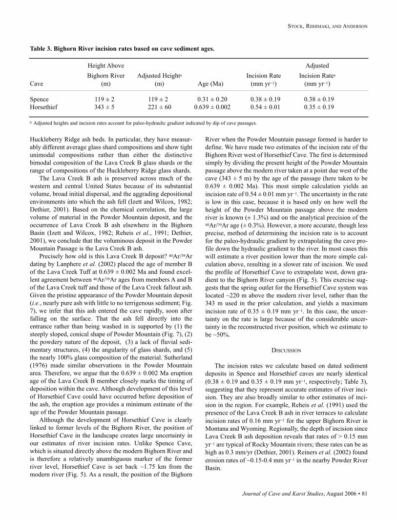
Journal of Cave and Karst Studies, August 2006 • 81
STOCK, RIIHIMAKI, AND ANDERSON
Huckleberry Ridge ash beds. In particular, they have measur-
ably different average glass shard compositions and show tight
unimodal compositions rather than either the distinctive
bimodal composition of the Lava Creek B glass shards or the
range of compositions of the Huckleberry Ridge glass shards.
The Lava Creek B ash is preserved across much of the
western and central United States because of its substantial
volume, broad initial dispersal, and the aggrading depositional
environments into which the ash fell (Izett and Wilcox, 1982;
Dethier, 2001). Based on the chemical correlation, the large
volume of material in the Powder Mountain deposit, and the
occurrence of Lava Creek B ash elsewhere in the Bighorn
Basin (Izett and Wilcox, 1982; Reheis et al., 1991; Dethier,
2001), we conclude that the voluminous deposit in the Powder
Mountain Passage is the Lava Creek B ash.
Precisely how old is this Lava Creek B deposit? 40Ar/39Ar
dating by Lanphere et al. (2002) placed the age of member B
of the Lava Creek Tuff at 0.639 ± 0.002 Ma and found excel-
lent agreement between 40Ar/39Ar ages from members A and B
of the Lava Creek tuff and those of the Lava Creek fallout ash.
Given the pristine appearance of the Powder Mountain deposit
(i.e., nearly pure ash with little to no terrigenous sediment; Fig.
7), we infer that this ash entered the cave rapidly, soon after
falling on the surface. That the ash fell directly into the
entrance rather than being washed in is supported by (1) the
steeply sloped, conical shape of Powder Mountain (Fig. 7), (2)
the powdery nature of the deposit, (3) a lack of fluvial sedi-
mentary structures, (4) the angularity of glass shards, and (5)
the nearly 100% glass composition of the material. Sutherland
(1976) made similar observations in the Powder Mountain
area. Therefore, we argue that the 0.639 ± 0.002 Ma eruption
age of the Lava Creek B member closely marks the timing of
deposition within the cave. Although development of this level
of Horsethief Cave could have occurred before deposition of
the ash, the eruption age provides a minimum estimate of the
age of the Powder Mountain passage.
Although the development of Horsethief Cave is clearly
linked to former levels of the Bighorn River, the position of
Horsethief Cave in the landscape creates large uncertainty in
our estimates of river incision rates. Unlike Spence Cave,
which is situated directly above the modern Bighorn River and
is therefore a relatively unambiguous marker of the former
river level, Horsethief Cave is set back ~1.75 km from the
modern river (Fig. 5). As a result, the position of the Bighorn
River when the Powder Mountain passage formed is harder to
define. We have made two estimates of the incision rate of the
Bighorn River west of Horsethief Cave. The first is determined
simply by dividing the present height of the Powder Mountain
passage above the modern river taken at a point due west of the
cave (343 ± 5 m) by the age of the passage (here taken to be
0.639 ± 0.002 Ma). This most simple calculation yields an
incision rate of 0.54 ± 0.01 mm yr–1. The uncertainty in the rate
is low in this case, because it is based only on how well the
height of the Powder Mountain passage above the modern
river is known (± 1.3%) and on the analytical precision of the40Ar/39Ar age (± 0.3%). However, a more accurate, though less
precise, method of determining the incision rate is to account
for the paleo-hydraulic gradient by extrapolating the cave pro-
file down the hydraulic gradient to the river. In most cases this
will estimate a river position lower than the more simple cal-
culation above, resulting in a slower rate of incision. We used
the profile of Horsethief Cave to extrapolate west, down gra-
dient to the Bighorn River canyon (Fig. 5). This exercise sug-
gests that the spring outlet for the Horsethief Cave system was
located ~220 m above the modern river level, rather than the
343 m used in the prior calculation, and yields a maximum
incision rate of 0.35 ± 0.19 mm yr–1. In this case, the uncer-
tainty on the rate is large because of the considerable uncer-
tainty in the reconstructed river position, which we estimate to
be ~50%.
DISCUSSION
The incision rates we calculate based on dated sediment
deposits in Spence and Horsethief caves are nearly identical
(0.38 ± 0.19 and 0.35 ± 0.19 mm yr–1, respectively; Table 3),
suggesting that they represent accurate estimates of river inci-
sion. They are also broadly similar to other estimates of inci-
sion in the region. For example, Reheis et al. (1991) used the
presence of the Lava Creek B ash in river terraces to calculate
incision rates of 0.16 mm yr–1 for the upper Bighorn River in
Montana and Wyoming. Regionally, the depth of incision since
Lava Creek B ash deposition reveals that rates of > 0.15 mm
yr–1 are typical of Rocky Mountain rivers; these rates can be as
high as 0.3 mm/yr (Dethier, 2001). Reiners et al. (2002) found
erosion rates of ~0.15-0.4 mm yr–1 in the nearby Powder River
Basin.
Table 3. Bighorn River incision rates based on cave sediment ages.
Height Above Adjusted
Bighorn River Adjusted Heighta Incision Rate Incision Ratea
Cave (m) (m) Age (Ma) (mm yr–1) (mm yr–1)
Spence 119 ± 2 119 ± 2 0.31 ± 0.20 0.38 ± 0.19 0.38 ± 0.19
Horsethief 343 ± 5 221 ± 60 0.639 ± 0.002 0.54 ± 0.01 0.35 ± 0.19
a Adjusted heights and incision rates account for paleo-hydraulic gradient indicated by dip of cave passages.
82 • Journal of Cave and Karst Studies, August 2006
AGE CONSTRAINTS ON CAVE DEVELOPMENT AND LANDSCAPE EVOLUTION IN THE BIGHORN BASIN OF WYOMING, USA
These independent incision rate estimates are within the
uncertainty of our calculated incision rates from the caves.
However, our best incision rate estimates are somewhat faster
(0.3–0.4 vs. 0.15–0.2 mm yr–1). If this discrepancy is real, and
not a product of our uncertainty, then there are several possible
explanations. The discrepancy may relate to geologic process-
es, such as isostatic uplift in response to sediment removal,
that increase river incision rates preferentially in certain parts
of the basin (Riihimaki, 2003). However, the discrepancy may
also result from bias resulting from the various methods used
to estimate incision rates. For example, incision estimates
based on river terraces (e.g., Reheis et al., 1991) could be erro-
neously fast because incision below the terraces may have
commenced well after deposition of the Lava Creek B ash. As
mentioned at the beginning of this paper, caves are also prone
to a similar bias, which can be further exacerbated depending
on what type of material is dated. Unless the dated deposits can
be shown to relate directly to cave development, then they rep-
resent minimum estimates of cave ages, and may underesti-
mate the actual cave ages considerably. For example, in order
to yield an incision rate of 0.15 mm yr–1, the age of Spence
Cave should be ~0.8 Ma, nearly 0.5 Ma older than the sand
burial age we determined. Although this is outside the range of
burial age uncertainty, we stress that while this age may accu-
rately date deposition of the sand, it may not accurately date
development of the cave. The same is true for the Horsethief
Cave ash deposit; the Lava Creek B ash could have fallen into
the Powder Mountain room well after the passage formed. The
0.11 Ma ash in Natural Trap Cave (Fig. 1; Gilbert, 1984) pre-
sents a useful example of this problem; if the age of this ash,
which erupted nearly 0.5 Ma after the Lava Creek B ash, were
combined with the height of Natural Trap Cave above the
Bighorn River to calculate an incision rate, the resulting rate
would be 3.63 mm yr–1. This rate is clearly much too fast, and
simply results from performing the calculation using dated
material that considerably underestimates the true age of the
cave. In the case of Spence and Horsethief caves, the nature of
the deposits and the consistent incision rates they provide
increase our confidence that the incision rates we have calcu-
lated are accurate. The important distinction between the age
of a cave deposit and the actual age of the cave it resides in,
noted decades ago (e.g., Ford et al., 1981; Atkinson and Rowe,
1992) and quantified more recently (Stock et al., 2005), might
explain why our calculated incision rates are higher than other
regional estimates, independent of geological processes. In any
case, the dated sediment deposits in Spence and Horsethief
caves set important constraints on river incision rates in the
Bighorn Basin since 0.31 and 0.64 Ma, respectively, and fur-
ther highlight the importance of cave studies in geomorphic
and tectonic research.
CONCLUSIONS
A cosmogenic 26Al/10Be burial date for fine (eolian) sand
within the entrance area of Spence Cave yields a burial age of
0.31 ± 0.19 million years. Tephrochronology suggests that a
fine white sediment deposit in the Powder Mountain area of
Horsethief Cave is the Lava Creek B fallout ash, erupted from
the Yellowstone Plateau volcanic field ca. 0.64 million years
ago. These two dates provide minimum estimates for the tim-
ing of cave development in the Bighorn Basin, and yield max-
imum incision rates for the Bighorn River of 0.38 ± 0.19 mm
yr–1 and 0.35 ± 0.19 mm yr–1, respectively. These rates are
broadly similar to independent estimates of river incision in
the region. An apparent two-fold discrepancy between the rates
based on the dated cave deposits and other independent esti-
mates may be due to geologic processes, but may also result
from the possibility that the dated deposits postdate the actual
time of cave development. Investigation of other caves (e.g.,Tongue River Cave, Cliff Dwellers Cave, Spirit Mountain
Caverns) may further clarify rates of landscape evolution in
the region.
ACKNOWLEDGEMENTS
We thank Shirley Bye-Jech and the Cody Office of the
Bureau of Land Management for permission to sample.
Michael E. Perkins at the University of Utah performed the
geochemical analysis of the Horsethief Cave sample, and
Robert Finkel at Lawrence Livermore National Laboratory
conducted accelerator mass spectrometry analysis of the
Spence Cave sample. We thank Wayne Sutherland for discus-
sions on the morphology and speleogenesis of Horsethief
Cave, and Andrew Flurkey and Darlene Anthony for helpful
reviews. This work was supported in part by a grant from the
National Science Foundation (EAR-0003604).
REFERENCES
Anderson, R.S., 1986, Erosion profiles due to particles
entrained by wind: Application of an eolian sediment-
transport model: Geological Society of America Bulletin,
v. 97, p. 1270–1278.
Anderson, R.S., Riihimaki, C.A., Safran, E.B., and
MacGregor, K.R., 2006, Facing reality: Late Cenozoic
evolution of smooth peaks, glacially ornamented valleys
and deep river gorges of Colorado’s Front Range, in Willet,
S.D., Hovius, N., Brandon, M.T., and Fisher, D.M., eds.,
Tectonics, Climate, and Landscape Evolution: Geological
Society of America Special Publication, 398 p.
Anthony, D.M., and Granger, D.E., 2004, A Late Tertiary ori-
gin for multilevel caves along the western escarpment of
the Cumberland Plateau, Tennessee and Kentucky, estab-
lished by cosmogenic 26Al and 10Be: Journal of Cave and
Karst Studies, v. 66, p. 46–55.
Atkinson, T.C., and Rowe, P.J., 1992, Applications of dating to
denudation chronology and landscape evolution, in M.
Ivanovich, R.S. Harmon eds., Uranium-series disequilibri-
um: Applications to Earth, Marine and Environmental
Sciences, Oxford Univ. Press, Oxford, p. 669-703.
Journal of Cave and Karst Studies, August 2006 • 83
Dethier, D.P., 2001, Pleistocene incision rates in the western
United States calibrated using Lava Creek B tephra:
Geology, v. 29, p. 783–786.
Egemeier, S.J., 1981, Cavern development by thermal waters:
National Speleological Society Bulletin, v. 43, p. 31–51.
Engel, A.S., Stern, L.A., and Bennett, P.C., 2004, Microbial
contributions to cave formation: New insights into sulfuric
acid speleogenesis: Geology, v. 32, p. 369–372.
Ford, D.C., Schwarcz, H.P., Drake, J.J., Gascoyne, M.,
Harmon, R.S., and Latham, A.G., 1981, Estimates of the
age of the existing relief within the southern Rocky
Mountains of Canada: Arctic and Alpine Research, v. 13, p.
1–10.
Ford, D.C. and Williams, P.W., 1989, Karst Geomorphology
and Hydrology: Chapman and Hall, London, U.K., 601 p.
Gilbert, B.M., 1984, A brief synopsis of the paleontology of
Natural Trap Cave, in Flurkey, A.J., ed., Guidebook of the
1984 National Speleological Society Convention, p.
17–18.
Granger, D.E., Kirchner, J.W., and Finkel, R.C., 1997,
Quaternary downcutting rate of the New River, Virginia,
measured from differential decay of cosmogenic 26Al and10Be in cave-deposited alluvium: Geology, v. 25, p.
107–110.
Granger, D.E., Fabel, D., and Palmer, A.N., 2001, Pliocene-
Pleistocene incision of the Green River, Kentucky, deter-
mined from radioactive decay of cosmogenic 26Al and 10Be
in Mammoth Cave sediments: Geological Society of
America Bulletin, v. 113, p. 825–826.
Granger, D.E., and Muzikar, P.F., 2001, Dating sediment bur-
ial with in situ-produced cosmogenic nuclides: Theory,
techniques, and limitations: Earth and Planetary Science
Letters, v. 188, p. 269–281.
Hill, C., Sutherland, W., and Tierney, L., 1976, Caves of
Wyoming, Geological Survey of Wyoming Bulletin 59,
University of Wyoming Press, Laramie, 230 p.
Izett, G.A., 1981, Volcanic ash beds: Recorders of upper
Cenozoic silicic pyroclastic volcanism in the western
United States: Journal of Geophysical Research, v. 86, p.
10,200–10,222.
Izett, G.A., and Wilcox, R.E., 1982, Map showing localities
and inferred distribution of the Huckleberry Ridge, Mesa
Falls, and Lava Creek ash beds (Pearlette family ash beds)
of Pliocene and Pleistocene age in the western United
States and southern Canada: U.S. Geological Survey
Miscellaneous Investigations Map I-1325, scale
1:4000000.
Kohl, C.P., and Nishiizumi, K., 1992, Chemical isolation of
quartz for measurement of in-situ produced cosmogenic
nuclides: Geochimica et Cosmochimica Acta, v. 56, p.
3583–3587.
Lanphere, M.A., Champion, D.E., Christiansen, R.L., Izett,
G.A., and Obradovich, J.D., 2002, Revised ages for tuffs of
the Yellowstone Plateau volcanic field: Assignment of the
Huckleberry Ridge Tuff to a new geomagnetic polarity
event: Geological Society of America Bulletin, v. 114, no.
5, p. 559–568.
Middleton, R., Brown, L., Desfouly-Arjomandy, B., and Klein,
J., 1993, On 10Be standards and the half-life of 10Be:
Nuclear Instruments and Methods in Physics Research B, v
82, p. 399–403.
Nash, W.P., 1992, Analysis of oxygen with the electron micro-
probe: Application to hydrous glass and minerals:
American Mineralogist, v. 77, p. 29–36.
Norris, T.L., Gancarz, A.J., Rokop, D.J., and Thomas, K.W.,
1983, Half-life of 26Al: Proceedings of the Fourteenth
Lunar and Planetary Science Conference, Part I: Journal of
Geophysical Research, v. 88, p. B331–B333.
Palmer, A.N., 1987, Cave levels and their interpretation:
National Speleological Society Bulletin, v. 49, p. 50–66.
Palmer, A.N., 1991, Origin and morphology of limestone
caves: Geological Society of America Bulletin, v. 103, p.
1–21.
Perkins, M.E., Nash, W.P., Brown, F.H., and Fleck, R.J., 1995,
Fallout tuffs of Trapper Creek Idaho – A record of Miocene
explosive volcanism in the Snake River Plains volcanic
province: Geological Society of America Bulletin, v. 107,
p. 1484–1506.
Polyak, V.J., McIntosh, W.C., Guven, N., and Provencio, P.,
1998, Age and origin of Carlsbad Cavern and related caves
from 40Ar/39Ar of alunite: Science, v. 279, p. 1919–1922.
Reheis, M.C., Palmquist, R.C., Agard, S.S., Jaworowski, C.,
Mears, B., Jr., Madole, R.F., Nelson, A.R., and Osborn,
G.D., 1991, Quaternary history of some southern and cen-
tral Rocky Mountain basins, in Morrison, R.B., ed.,Quaternary nonglacial geology: Conterminous U.S.:
Boulder, Colorado, Geological Society of America,
Geology of North America, v. K-2, p. 407–440.
Reiners, P.W., and Heffern, E.L., 2002, Pleistocene exhuma-
tion rates of Wyoming intermontane basins from (U-
Th)/He dating of clinker: Geological Society of America
Abstracts With Programs, paper no. 144-4.
Riihimaki, C.A., 2003, Quantitative constraints on the glacial
and fluvial evolution of alpine landscapes [Ph.D. thesis]:
University of California, Santa Cruz.
Riihimaki, C.A., Anderson, R.S., Safran, E.B., Dethier, D.P.,
Finkel, R.C., and Bierman, P.R., 2006, Longevity and pro-
gressive abandonment of the Rocky Flats surface, Front
Range, Colorado: Geomorphology, v. 78, p. 265–278.
Sasowsky, I.D., White, W.B., and Schmidt, V.A., 1995,
Determination of stream-incision rate in the Appalachian
plateaus by using cave-sediment magnetostratigraphy:
Geology, v. 23, p. 415–418.
Stock, G.M., Anderson, R.S., and Finkel, R.C., 2004, Pace of
landscape evolution in the Sierra Nevada, California,
revealed by cosmogenic dating of cave sediments:
Geology, v. 32, p. 193–196.
Stock, G.M., Granger, D.E., Sasowsky, I.D., Anderson, R.S.,
and Finkel, R.C., 2005, Comparison of U–Th, paleomag-
netism, and cosmogenic burial methods for dating caves:
STOCK, RIIHIMAKI, AND ANDERSON

84 • Journal of Cave and Karst Studies, August 2006
AGE CONSTRAINTS ON CAVE DEVELOPMENT AND LANDSCAPE EVOLUTION IN THE BIGHORN BASIN OF WYOMING, USA
Implications for landscape evolution studies: Earth and
Planetary Science Letters, v. 236, p. 388–403.
Stone, J.O., 2000, Air pressure and cosmogenic isotope pro-
duction: Journal of Geophysical Research, v. 105, p.
753–759.
Sutherland, W.M, 1976, The geomorphic history of Horsethief
Cave, Bighorn Mountains, Wyoming [M.S. thesis]:
Laramie, University of Wyoming, 73 p.
White, W.B., 1988, Geomorphology and hydrology of karst
terrains: Oxford University Press, New York, 464 p.
Williams, S.K., 1994, Late Cenozoic tephrostratigraphy of
deep sediment cores from the Bonneville basin, northwest
Utah: Geological Society of America Bulletin, v. 106, p.
1517–1530.
Zheng, X., He, L., and Wu, J., 2004, Vertical profiles of mass
flux for windblown sand movement: Journal of
Geophysical Research, v. 109, B01106, doi:
10.1029/2003JB002656.
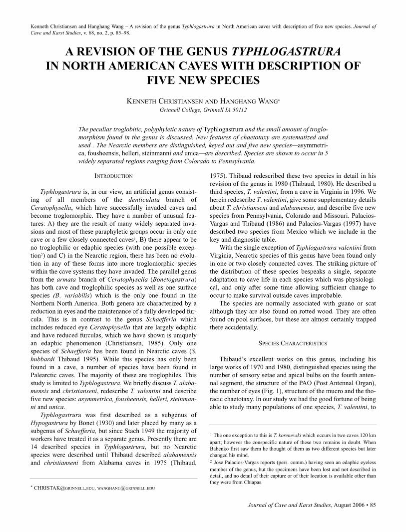
Journal of Cave and Karst Studies, August 2006 • 85
Kenneth Christiansen and Hanghang Wang – A revision of the genus Typhlogastrura in North American caves with description of five new species. Journal ofCave and Karst Studies, v. 68, no. 2, p. 85–98.
INTRODUCTION
Typhlogastrura is, in our view, an artificial genus consist-
ing of all members of the denticulata branch of
Ceratophysella, which have successfully invaded caves and
become troglomorphic. They have a number of unusual fea-
tures: A) they are the result of many widely separated inva-
sions and most of these paraphyletic groups occur in only one
cave or a few closely connected caves1, B) there appear to be
no troglophilic or edaphic species (with one possible excep-
tion2) and C) in the Nearctic region, there has been no evolu-
tion in any of these forms into more troglomorphic species
within the cave systems they have invaded. The parallel genus
from the armata branch of Ceratophysella (Bonetogastrura)
has both cave and troglophilic species as well as one surface
species (B. variabilis) which is the only one found in the
Northern North America. Both genera are characterized by a
reduction in eyes and the maintenance of a fully developed fur-
cula. This is in contrast to the genus Schaefferia which
includes reduced eye Ceratophysella that are largely edaphic
and have reduced furculas, which we have shown is uniquely
an edaphic phenomenon (Christiansen, 1985). Only one
species of Schaefferia has been found in Nearctic caves (S.hubbardi Thibaud 1995). While this species has only been
found in a cave, a number of species have been found in
Palearctic caves. The majority of these are troglophiles. This
study is limited to Typhlogastrura. We briefly discuss T. alaba-mensis and christianseni, redescribe T. valentini and describe
five new species: asymmetrica, fousheensis, helleri, steinman-ni and unica.
Typhlogastrura was first described as a subgenus of
Hypogastrura by Bonet (1930) and later placed by many as a
subgenus of Schaefferia, but since Stach 1949 the majority of
workers have treated it as a separate genus. Presently there are
14 described species in Typhlogastrura, but no Nearctic
species were described until Thibaud described alabamensisand christianseni from Alabama caves in 1975 (Thibaud,
1975). Thibaud redescribed these two species in detail in his
revision of the genus in 1980 (Thibaud, 1980). He described a
third species, T. valentini, from a cave in Virginia in 1996. We
herein redescribe T. valentini, give some supplementary details
about T. christianseni and alabamensis, and describe five new
species from Pennsylvania, Colorado and Missouri. Palacios-
Vargas and Thibaud (1986) and Palacios-Vargas (1997) have
described two species from Mexico which we include in the
key and diagnostic table.
With the single exception of Typhlogastrura valentini from
Virginia, Nearctic species of this genus have been found only
in one or two closely connected caves. The striking picture of
the distribution of these species bespeaks a single, separate
adaptation to cave life in each species which was physiologi-
cal, and only after some time allowing sufficient change to
occur to make survival outside caves improbable.
The species are normally associated with guano or scat
although they are also found on rotted wood. They are often
found on pool surfaces, but these are almost certainly trapped
there accidentally.
SPECIES CHARACTERISTICS
Thibaud’s excellent works on this genus, including his
large works of 1970 and 1980, distinguished species using the
number of sensory setae and apical bulbs on the fourth anten-
nal segment, the structure of the PAO (Post Antennal Organ),
the number of eyes (Fig. 1), structure of the mucro and the tho-
racic chaetotaxy. In our study we had the good fortune of being
able to study many populations of one species, T. valentini, to
A REVISION OF THE GENUS TYPHLOGASTRURAIN NORTH AMERICAN CAVES WITH DESCRIPTION OF
FIVE NEW SPECIES
KENNETH CHRISTIANSEN AND HANGHANG WANG*
Grinnell College, Grinnell IA 50112
The peculiar troglobitic, polyphyletic nature of Typhlogastrura and the small amount of troglo-morphism found in the genus is discussed. New features of chaetotaxy are systematized andused . The Nearctic members are distinguished, keyed out and five new species—asymmetri-
ca, fousheensis, helleri, steinmanni and unica—are described. Species are shown to occur in 5widely separated regions ranging from Colorado to Pennsylvania.
* [email protected], [email protected]
1 The one exception to this is T. korenevski which occurs in two caves 120 km
apart; however the conspecific nature of these two remains in doubt. When
Babenko first saw them he thought of them as two different species but later
changed his mind.2 Jose Palacios-Vargas reports (pers. comm.) having seen an edaphic eyeless
member of the genus, but the specimens have been lost and not described in
detail, and no detail of their capture or of their location is available other than
they were from Chiapas.
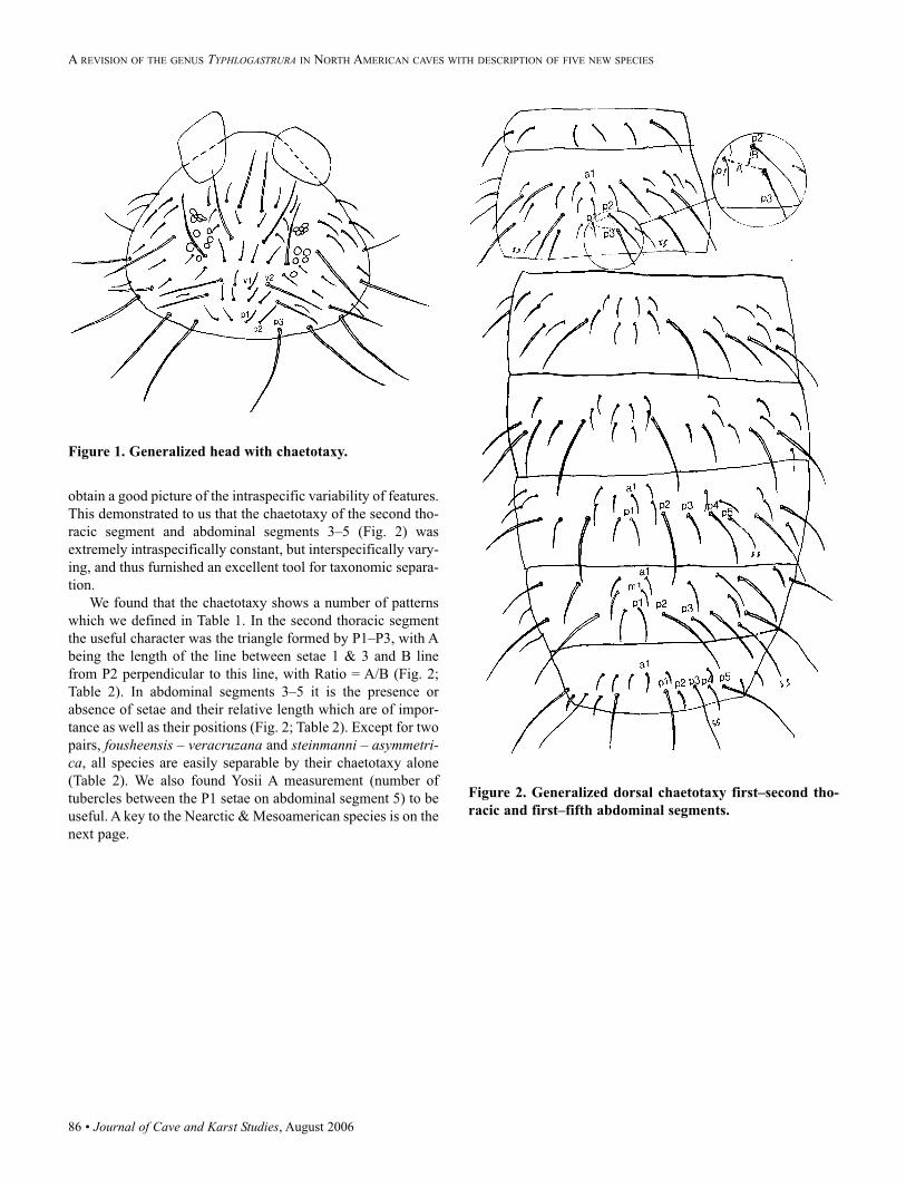
86 • Journal of Cave and Karst Studies, August 2006
obtain a good picture of the intraspecific variability of features.
This demonstrated to us that the chaetotaxy of the second tho-
racic segment and abdominal segments 3–5 (Fig. 2) was
extremely intraspecifically constant, but interspecifically vary-
ing, and thus furnished an excellent tool for taxonomic separa-
tion.
We found that the chaetotaxy shows a number of patterns
which we defined in Table 1. In the second thoracic segment
the useful character was the triangle formed by P1–P3, with A
being the length of the line between setae 1 & 3 and B line
from P2 perpendicular to this line, with Ratio = A/B (Fig. 2;
Table 2). In abdominal segments 3–5 it is the presence or
absence of setae and their relative length which are of impor-
tance as well as their positions (Fig. 2; Table 2). Except for two
pairs, fousheensis – veracruzana and steinmanni – asymmetri-ca, all species are easily separable by their chaetotaxy alone
(Table 2). We also found Yosii A measurement (number of
tubercles between the P1 setae on abdominal segment 5) to be
useful. A key to the Nearctic & Mesoamerican species is on the
next page.
Figure 1. Generalized head with chaetotaxy.
Figure 2. Generalized dorsal chaetotaxy first–second tho-
racic and first–fifth abdominal segments.
A REVISION OF THE GENUS TYPHLOGASTRURA IN NORTH AMERICAN CAVES WITH DESCRIPTION OF FIVE NEW SPECIES
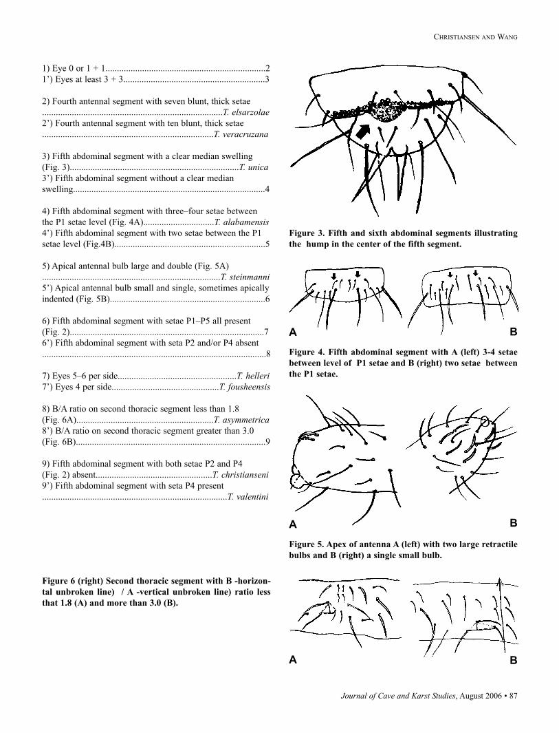
Journal of Cave and Karst Studies, August 2006 • 87
CHRISTIANSEN AND WANG
1) Eye 0 or 1 + 1......................................................................2
1’) Eyes at least 3 + 3..............................................................3
2) Fourth antennal segment with seven blunt, thick setae
...............................................................................T. elsarzolae2’) Fourth antennal segment with ten blunt, thick setae
...........................................................................T. veracruzana
3) Fifth abdominal segment with a clear median swelling
(Fig. 3)..........................................................................T. unica3’) Fifth abdominal segment without a clear median
swelling....................................................................................4
4) Fifth abdominal segment with three–four setae between
the P1 setae level (Fig. 4A)...............................T. alabamensis4’) Fifth abdominal segment with two setae between the P1
setae level (Fig.4B)..................................................................5
5) Apical antennal bulb large and double (Fig. 5A)
..............................................................................T. steinmanni5’) Apical antennal bulb small and single, sometimes apically
indented (Fig. 5B)....................................................................6
6) Fifth abdominal segment with setae P1–P5 all present
(Fig. 2).....................................................................................7
6’) Fifth abdominal segment with seta P2 and/or P4 absent
..................................................................................................8
7) Eyes 5–6 per side....................................................T. helleri7’) Eyes 4 per side...............................................T. fousheensis
8) B/A ratio on second thoracic segment less than 1.8
(Fig. 6A)............................................................T. asymmetrica8’) B/A ratio on second thoracic segment greater than 3.0
(Fig. 6B)...................................................................................9
9) Fifth abdominal segment with both setae P2 and P4
(Fig. 2) absent...................................................T. christianseni9’) Fifth abdominal segment with seta P4 present
.................................................................................T. valentini
Figure 3. Fifth and sixth abdominal segments illustrating
the hump in the center of the fifth segment.
Figure 4. Fifth abdominal segment with A (left) 3-4 setae
between level of P1 setae and B (right) two setae between
the P1 setae.
Figure 5. Apex of antenna A (left) with two large retractile
bulbs and B (right) a single small bulb.
Figure 6 (right) Second thoracic segment with B -horizon-
tal unbroken line) / A -vertical unbroken line) ratio less
that 1.8 (A) and more than 3.0 (B).
A B
A B
A B
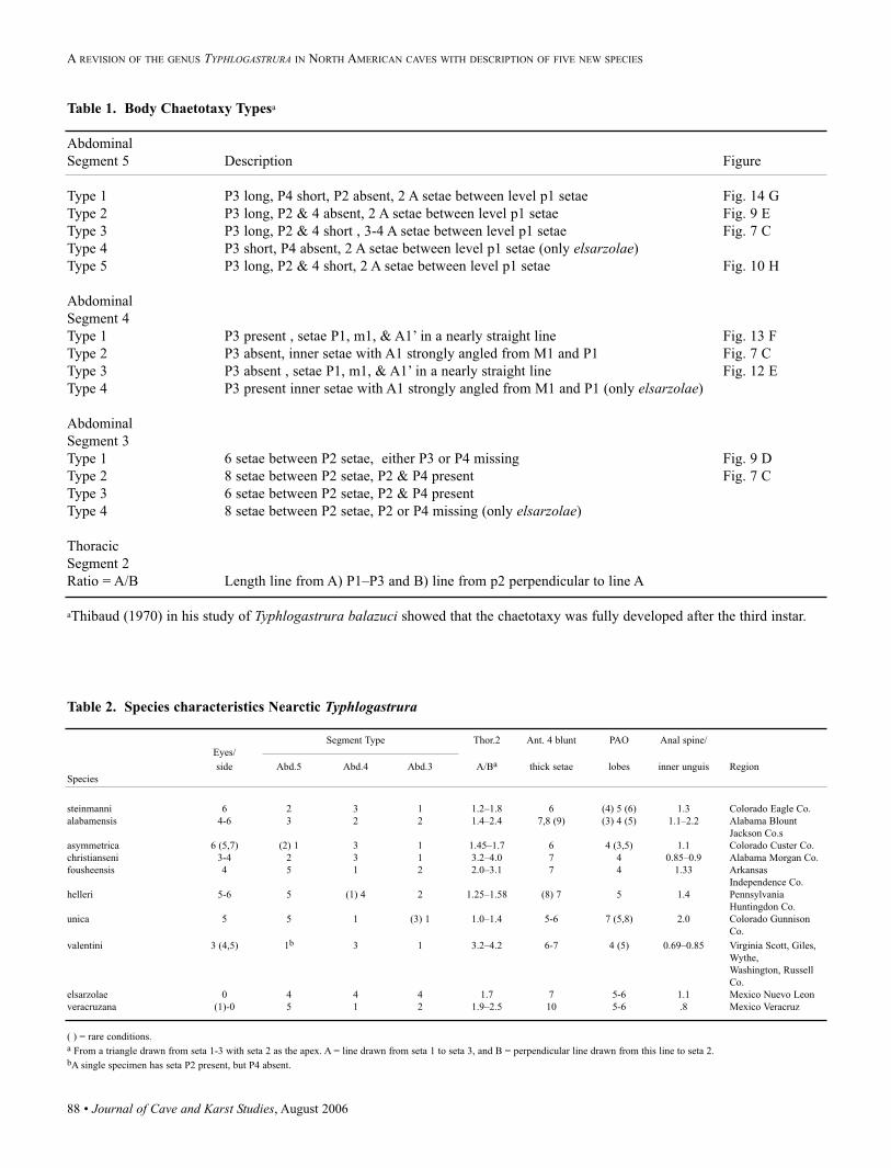
88 • Journal of Cave and Karst Studies, August 2006
Table 1. Body Chaetotaxy Typesa
Abdominal
Segment 5 Description Figure
Type 1 P3 long, P4 short, P2 absent, 2 A setae between level p1 setae Fig. 14 G
Type 2 P3 long, P2 & 4 absent, 2 A setae between level p1 setae Fig. 9 E
Type 3 P3 long, P2 & 4 short , 3-4 A setae between level p1 setae Fig. 7 C
Type 4 P3 short, P4 absent, 2 A setae between level p1 setae (only elsarzolae)
Type 5 P3 long, P2 & 4 short, 2 A setae between level p1 setae Fig. 10 H
Abdominal
Segment 4
Type 1 P3 present , setae P1, m1, & A1’ in a nearly straight line Fig. 13 F
Type 2 P3 absent, inner setae with A1 strongly angled from M1 and P1 Fig. 7 C
Type 3 P3 absent , setae P1, m1, & A1’ in a nearly straight line Fig. 12 E
Type 4 P3 present inner setae with A1 strongly angled from M1 and P1 (only elsarzolae)
Abdominal
Segment 3
Type 1 6 setae between P2 setae, either P3 or P4 missing Fig. 9 D
Type 2 8 setae between P2 setae, P2 & P4 present Fig. 7 C
Type 3 6 setae between P2 setae, P2 & P4 present
Type 4 8 setae between P2 setae, P2 or P4 missing (only elsarzolae)
Thoracic
Segment 2
Ratio = A/B Length line from A) P1–P3 and B) line from p2 perpendicular to line A
aThibaud (1970) in his study of Typhlogastrura balazuci showed that the chaetotaxy was fully developed after the third instar.
Table 2. Species characteristics Nearctic Typhlogastrura
Segment Type Thor.2 Ant. 4 blunt PAO Anal spine/
Eyes/
side Abd.5 Abd.4 Abd.3 A/Ba thick setae lobes inner unguis Region
Species
steinmanni 6 2 3 1 1.2–1.8 6 (4) 5 (6) 1.3 Colorado Eagle Co.
alabamensis 4-6 3 2 2 1.4–2.4 7,8 (9) (3) 4 (5) 1.1–2.2 Alabama Blount
Jackson Co.s
asymmetrica 6 (5,7) (2) 1 3 1 1.45–1.7 6 4 (3,5) 1.1 Colorado Custer Co.
christianseni 3-4 2 3 1 3.2–4.0 7 4 0.85–0.9 Alabama Morgan Co.
fousheensis 4 5 1 2 2.0–3.1 7 4 1.33 Arkansas
Independence Co.
helleri 5-6 5 (1) 4 2 1.25–1.58 (8) 7 5 1.4 Pennsylvania
Huntingdon Co.
unica 5 5 1 (3) 1 1.0–1.4 5-6 7 (5,8) 2.0 Colorado Gunnison
Co.
valentini 3 (4,5) 1b 3 1 3.2–4.2 6-7 4 (5) 0.69–0.85 Virginia Scott, Giles,
Wythe,
Washington, Russell
Co.
elsarzolae 0 4 4 4 1.7 7 5-6 1.1 Mexico Nuevo Leon
veracruzana (1)-0 5 1 2 1.9–2.5 10 5-6 .8 Mexico Veracruz
( ) = rare conditions. a From a triangle drawn from seta 1-3 with seta 2 as the apex. A = line drawn from seta 1 to seta 3, and B = perpendicular line drawn from this line to seta 2. bA single specimen has seta P2 present, but P4 absent.
A REVISION OF THE GENUS TYPHLOGASTRURA IN NORTH AMERICAN CAVES WITH DESCRIPTION OF FIVE NEW SPECIES
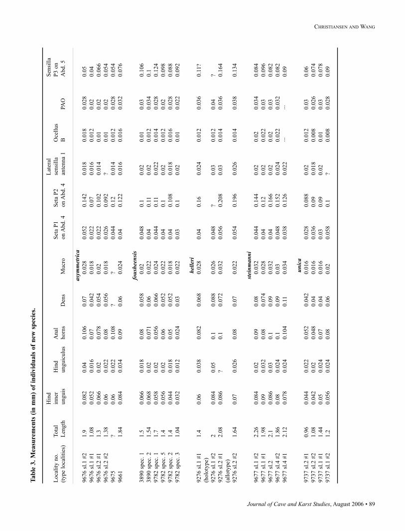
Journal of Cave and Karst Studies, August 2006 • 89
CHRISTIANSEN AND WANG
Tab
le 3
. M
easu
rem
ents
(in
mm
) of
ind
ivid
uals
of
new
sp
ecie
s.
Hin
dL
ater
alS
ensi
lla
Loca
lity
no.
Tota
lin
ner
Hin
dA
nal
Set
a P
1S
eta
P2
sensi
lla
Oce
llus
P3 o
n
(type
loca
liti
es)
Len
gth
unguis
ungu
iculu
shorn
sD
ens
Mucr
oon A
bd.
4on A
bd.
4an
tenna
1B
PAO
Abd.
5
asym
met
rica
9676 s
l.1 #
21.9
0.0
82
0.0
40.1
06
0.0
70.0
28
0.0
52
0.1
42
0.0
18
0.0
18
0.0
28
0.0
5
9676 s
l.1 #
11.0
80.0
52
0.0
16
0.0
70.0
42
0.0
18
0.0
22
0.0
70.0
16
0.0
12
0.0
20.0
4
9676 s
l.2 #
11.3
0.0
66
0.0
20.0
78
0.0
54
0.0
20.0
22
0.1
02
0.0
14
0.0
10.0
20.0
66
9676 s
l.2 #
21.3
80.0
60.0
22
0.0
80.0
56
0.0
18
0.0
26
0.0
92
?0.0
10.0
20.0
54
9675
?0.0
60.0
22
0.1
08
??
0.0
44
0.1
20.0
14
0.0
12
0.0
28
0.0
54
9661
1.8
40.0
84
0.0
34
0.0
90.0
60.0
24
0.0
40.1
22
0.0
16
0.0
16
0.0
32
0.0
76
fous
heen
sis
3890 s
pec
. 1
1.5
0.0
66
0.0
18
0.0
80.0
58
0.0
20.0
48
0.1
0.0
20.0
10.0
30.1
06
3890 s
pec
. 2
1.5
40.0
68
0.0
20.0
71
0.0
60.0
22
0.0
40.1
10.0
20.0
12
0.0
34
0.1
9782 s
pec
. 1
1.7
0.0
58
0.0
20.0
56
0.0
66
0.0
24
0.0
44
0.1
10.0
22
0.0
14
0.0
28
0.1
24
9782 s
pec
. 5
1.4
0.0
56
0.0
20.0
60.0
52
0.0
22
0.0
40.1
0.0
20.0
12
0.0
20.0
98
9782 s
pec
. 2
1.4
0.0
44
0.0
18
0.0
50.0
52
0.0
18
0.0
40.1
08
0.0
18
0.0
16
0.0
28
0.0
88
9782 s
pec
. 3
1.0
40.0
32
0.0
12
0.0
24
0.0
30.0
22
0.0
30.1
0.0
20.0
10.0
22
0.0
92
helle
ri9276 s
l.1 #
11.4
0.0
60.0
38
0.0
82
0.0
68
0.0
28
0.0
40.1
60.0
24
0.0
12
0.0
36
0.1
1?
(holo
type)
9276 s
l.1 #
22
0.0
84
0.0
50.1
0.0
88
0.0
26
0.0
48
?0.0
30.0
12
0.0
4?
9276 s
l.2 #
12.0
80.0
86
?0.1
0.0
72
0.0
32
0.0
56
0.2
08
0.0
30.0
14
0.0
36
0.1
64
(all
oty
pe)
9276 s
l.2 #
21.6
40.0
70.0
26
0.0
80.0
70.0
22
0.0
54
0.1
96
0.0
26
0.0
14
0.0
38
0.1
34
stei
nman
ni9677 s
l.1 #
22.2
60.0
84
0.0
20.0
90.0
80.0
32
0.0
44
0.1
44
0.0
20.0
20.0
34
0.0
84
9677 s
l.1 #
11.9
80.0
90.0
32
0.0
80.0
74
0.0
28
0.0
40.1
20.0
20.0
22
0.0
30.0
96
9677 s
l.2
2.1
0.0
86
0.0
30.1
0.0
90.0
32
0.0
40.1
66
0.0
20.0
20.0
30.0
82
9677 s
l.4 #
21.8
60.0
80.0
24
0.1
0.0
90.0
30.0
48
0.1
52
0.0
24
0.0
22
0.0
32
0.0
82
9677 s
l.4 #
12.1
20.0
78
0.0
24
0.1
04
0.1
10.0
34
0.0
38
0.1
26
0.0
22
···
···
0.0
9
unic
a9737 s
l.2 #
10.9
60.0
44
0.0
22
0.0
52
0.0
42
0.0
16
0.0
28
0.0
88
0.0
20.0
12
0.0
30.0
6
9737 s
l.2 #
21.0
80.0
42
0.0
20.0
48
0.0
40.0
16
0.0
36
0.0
90.0
18
0.0
08
0.0
26
0.0
74
9737 s
l.1 #
11.4
40.0
50.0
24
0.0
70.0
40.0
16
0.0
30.0
90.0
20.0
10.0
30.0
78
9737 s
l.1 #
21.2
0.0
56
0.0
24
0.0
80.0
60.0
20.0
58
0.1
?0.0
08
0.0
28
0.0
9
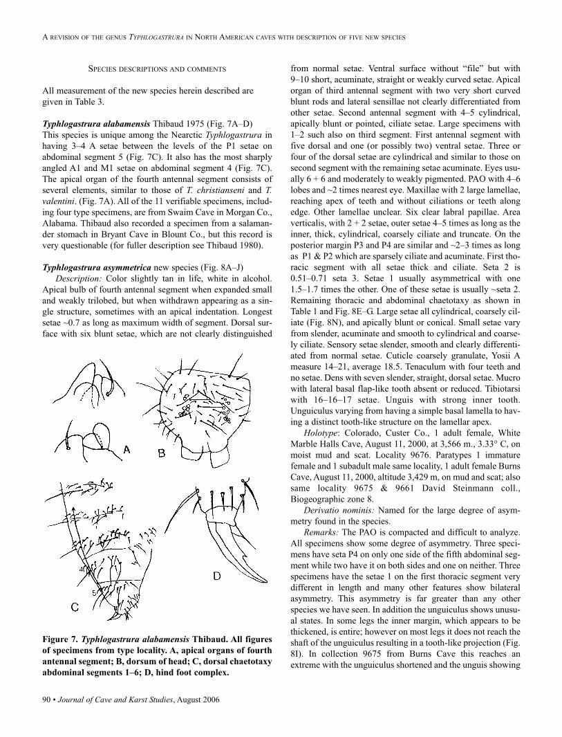
90 • Journal of Cave and Karst Studies, August 2006
SPECIES DESCRIPTIONS AND COMMENTS
All measurement of the new species herein described are
given in Table 3.
Typhlogastrura alabamensis Thibaud 1975 (Fig. 7A–D)
This species is unique among the Nearctic Typhlogastrura in
having 3–4 A setae between the levels of the P1 setae on
abdominal segment 5 (Fig. 7C). It also has the most sharply
angled A1 and M1 setae on abdominal segment 4 (Fig. 7C).
The apical organ of the fourth antennal segment consists of
several elements, similar to those of T. christianseni and T.valentini. (Fig. 7A). All of the 11 verifiable specimens, includ-
ing four type specimens, are from Swaim Cave in Morgan Co.,
Alabama. Thibaud also recorded a specimen from a salaman-
der stomach in Bryant Cave in Blount Co., but this record is
very questionable (for fuller description see Thibaud 1980).
Typhlogastrura asymmetrica new species (Fig. 8A–J)
Description: Color slightly tan in life, white in alcohol.
Apical bulb of fourth antennal segment when expanded small
and weakly trilobed, but when withdrawn appearing as a sin-
gle structure, sometimes with an apical indentation. Longest
setae ~0.7 as long as maximum width of segment. Dorsal sur-
face with six blunt setae, which are not clearly distinguished
from normal setae. Ventral surface without “file” but with
9–10 short, acuminate, straight or weakly curved setae. Apical
organ of third antennal segment with two very short curved
blunt rods and lateral sensillae not clearly differentiated from
other setae. Second antennal segment with 4–5 cylindrical,
apically blunt or pointed, ciliate setae. Large specimens with
1–2 such also on third segment. First antennal segment with
five dorsal and one (or possibly two) ventral setae. Three or
four of the dorsal setae are cylindrical and similar to those on
second segment with the remaining setae acuminate. Eyes usu-
ally 6 + 6 and moderately to weakly pigmented. PAO with 4–6
lobes and ~2 times nearest eye. Maxillae with 2 large lamellae,
reaching apex of teeth and without ciliations or teeth along
edge. Other lamellae unclear. Six clear labral papillae. Area
verticalis, with 2 + 2 setae, outer setae 4–5 times as long as the
inner, thick, cylindrical, coarsely ciliate and truncate. On the
posterior margin P3 and P4 are similar and ~2–3 times as long
as P1 & P2 which are sparsely ciliate and acuminate. First tho-
racic segment with all setae thick and ciliate. Seta 2 is
0.51–0.71 seta 3. Setae 1 usually asymmetrical with one
1.5–1.7 times the other. One of these setae is usually ~seta 2.
Remaining thoracic and abdominal chaetotaxy as shown in
Table 1 and Fig. 8E–G. Large setae all cylindrical, coarsely cil-
iate (Fig. 8N), and apically blunt or conical. Small setae vary
from slender, acuminate and smooth to cylindrical and coarse-
ly ciliate. Sensory setae slender, smooth and clearly differenti-
ated from normal setae. Cuticle coarsely granulate, Yosii A
measure 14–21, average 18.5. Tenaculum with four teeth and
no setae. Dens with seven slender, straight, dorsal setae. Mucro
with lateral basal flap-like tooth absent or reduced. Tibiotarsi
with 16–16–17 setae. Unguis with strong inner tooth.
Unguiculus varying from having a simple basal lamella to hav-
ing a distinct tooth-like structure on the lamellar apex.
Holotype: Colorado, Custer Co., 1 adult female, White
Marble Halls Cave, August 11, 2000, at 3,566 m., 3.33° C, on
moist mud and scat. Locality 9676. Paratypes 1 immature
female and 1 subadult male same locality, 1 adult female Burns
Cave, August 11, 2000, altitude 3,429 m, on mud and scat; also
same locality 9675 & 9661 David Steinmann coll.,
Biogeographic zone 8.
Derivatio nominis: Named for the large degree of asym-
metry found in the species.
Remarks: The PAO is compacted and difficult to analyze.
All specimens show some degree of asymmetry. Three speci-
mens have seta P4 on only one side of the fifth abdominal seg-
ment while two have it on both sides and one on neither. Three
specimens have the setae 1 on the first thoracic segment very
different in length and many other features show bilateral
asymmetry. This asymmetry is far greater than any other
species we have seen. In addition the unguiculus shows unusu-
al states. In some legs the inner margin, which appears to be
thickened, is entire; however on most legs it does not reach the
shaft of the unguiculus resulting in a tooth-like projection (Fig.
8I). In collection 9675 from Burns Cave this reaches an
extreme with the unguiculus shortened and the unguis showing
Figure 7. Typhlogastrura alabamensis Thibaud. All figures
of specimens from type locality. A, apical organs of fourth
antennal segment; B, dorsum of head; C, dorsal chaetotaxy
abdominal segments 1–6; D, hind foot complex.
A REVISION OF THE GENUS TYPHLOGASTRURA IN NORTH AMERICAN CAVES WITH DESCRIPTION OF FIVE NEW SPECIES
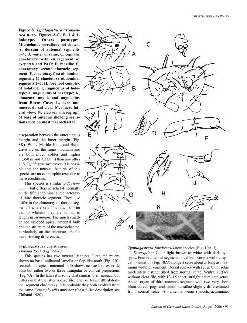
Journal of Cave and Karst Studies, August 2006 • 91
CHRISTIANSEN AND WANG
a separation between the outer unguis
margin and the inner margin (Fig.
8K). White Marble Halls and Burns
Cave are on the same mountain and
are both much colder and higher
(1,350 m and 1,213 m) than any other
U.S. Typhlogastrura caves. It is possi-
ble that the unusual features of this
species are an ecomorphic response to
these conditions.
This species is similar to T. stein-manni but differs in seta P4 normally
on the fifth abdominal and chaetotaxy
of third thoracic segment, They also
differ in the chatotaxy of thorcic seg-
ment 1 where seta 1 is much shorter
than 3 whereas they are similar in
length in steinmani. The much small-
er and unlobed apical antennal bulb
and the structure of the macrochaetae,
particularly on the antennae, are the
most striking differences.
Typhlogastrura christianseni
Thibaud 1975 (Fig. 9A–F)This species has two unusual features. First, the mucro
shows no basal unilateral lamella or flap-like tooth (Fig. 9B);
second, the apical antennal bulb shows no sac-like exsertile
bulb but rather two or three triangular or conical projections
(Fig. 9A). In the latter it is somewhat similar to T. valentini but
differs in that the latter is exsertile. They differ in fifth abdom-
inal segment chaetotaxy. It is probable they both evolved from
the same Ceratophysella ancestor (for a fuller description see
Thibaud 1980).
Typhlogastrura fousheensis new species (Fig. 10A–I)
Description: Color light brown to white with dark eye-
spots. Fourth antennal segment apical bulb simple without api-
cal indentation (Fig. 10A). Longest setae about as long as max-
imum width of segment. Dorsal surface with seven blunt setae
moderately distinguished from normal setae. Ventral surface
without clear file, with 13–15 short, straight acuminate setae.
Apical organ of third antennal segment with two very short
blunt curved pegs and lateral sensillae slightly differentiated
from normal setae. All antennal setae smooth, acuminate,
Figure 8. Typhlogastrura asymmet-rica n. sp. Figures A-C, E, I & L
holotype. Others paratypes.
Microchatae serrations not shown.
A, dorsum of antennal segments
3–4; B, venter of same; C, cephalic
chaetotaxy with enlargement of
eyepatch and PAO; D, maxilla; E,
chaetotaxy second thoracic seg-
ment; F, chaetotaxy first abdominal
segment; G, chaetotaxy abdominal
segments 2–5; H, fore foot complex
of holotype; I, unguiculus of holo-
type; J, unguiculus of paratype; K,
abnormal unguis and unguiculus
from Burns Cave; L, dens and
mucro, dorsal view; M, mucro lat-
eral view; N, electron micrograph
of base of antenna showing serra-
tions seen on most macrochaetae.
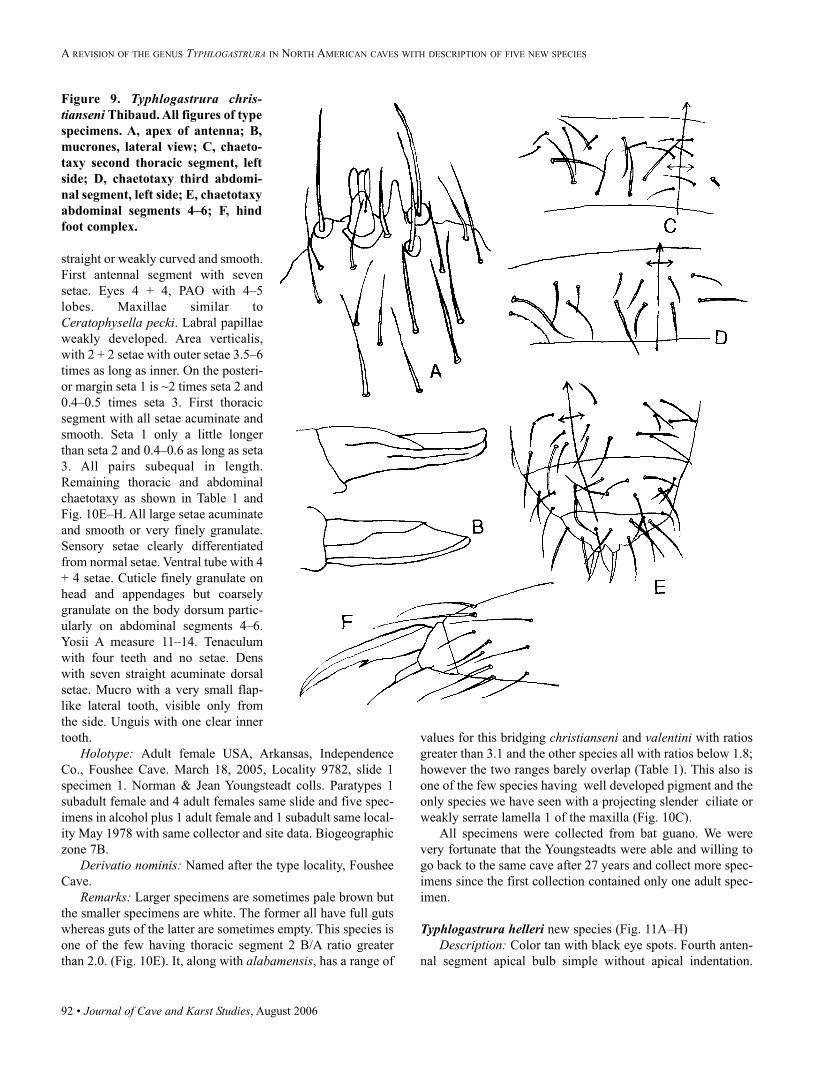
92 • Journal of Cave and Karst Studies, August 2006
straight or weakly curved and smooth.
First antennal segment with seven
setae. Eyes 4 + 4, PAO with 4–5
lobes. Maxillae similar to
Ceratophysella pecki. Labral papillae
weakly developed. Area verticalis,
with 2 + 2 setae with outer setae 3.5–6
times as long as inner. On the posteri-
or margin seta 1 is ~2 times seta 2 and
0.4–0.5 times seta 3. First thoracic
segment with all setae acuminate and
smooth. Seta 1 only a little longer
than seta 2 and 0.4–0.6 as long as seta
3. All pairs subequal in length.
Remaining thoracic and abdominal
chaetotaxy as shown in Table 1 and
Fig. 10E–H. All large setae acuminate
and smooth or very finely granulate.
Sensory setae clearly differentiated
from normal setae. Ventral tube with 4
+ 4 setae. Cuticle finely granulate on
head and appendages but coarsely
granulate on the body dorsum partic-
ularly on abdominal segments 4–6.
Yosii A measure 11–14. Tenaculum
with four teeth and no setae. Dens
with seven straight acuminate dorsal
setae. Mucro with a very small flap-
like lateral tooth, visible only from
the side. Unguis with one clear inner
tooth.
Holotype: Adult female USA, Arkansas, Independence
Co., Foushee Cave. March 18, 2005, Locality 9782, slide 1
specimen 1. Norman & Jean Youngsteadt colls. Paratypes 1
subadult female and 4 adult females same slide and five spec-
imens in alcohol plus 1 adult female and 1 subadult same local-
ity May 1978 with same collector and site data. Biogeographic
zone 7B.
Derivatio nominis: Named after the type locality, Foushee
Cave.
Remarks: Larger specimens are sometimes pale brown but
the smaller specimens are white. The former all have full guts
whereas guts of the latter are sometimes empty. This species is
one of the few having thoracic segment 2 B/A ratio greater
than 2.0. (Fig. 10E). It, along with alabamensis, has a range of
values for this bridging christianseni and valentini with ratios
greater than 3.1 and the other species all with ratios below 1.8;
however the two ranges barely overlap (Table 1). This also is
one of the few species having well developed pigment and the
only species we have seen with a projecting slender ciliate or
weakly serrate lamella 1 of the maxilla (Fig. 10C).
All specimens were collected from bat guano. We were
very fortunate that the Youngsteadts were able and willing to
go back to the same cave after 27 years and collect more spec-
imens since the first collection contained only one adult spec-
imen.
Typhlogastrura helleri new species (Fig. 11A–H)
Description: Color tan with black eye spots. Fourth anten-
nal segment apical bulb simple without apical indentation.
Figure 9. Typhlogastrura chris-tianseni Thibaud. All figures of type
specimens. A, apex of antenna; B,
mucrones, lateral view; C, chaeto-
taxy second thoracic segment, left
side; D, chaetotaxy third abdomi-
nal segment, left side; E, chaetotaxy
abdominal segments 4–6; F, hind
foot complex.
A REVISION OF THE GENUS TYPHLOGASTRURA IN NORTH AMERICAN CAVES WITH DESCRIPTION OF FIVE NEW SPECIES
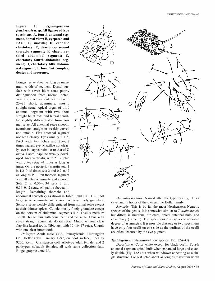
Journal of Cave and Karst Studies, August 2006 • 93
CHRISTIANSEN AND WANG
Longest setae about as long as maxi-
mum width of segment. Dorsal sur-
face with seven blunt setae poorly
distinguished from normal setae.
Ventral surface without clear file with
23–25 short, acuminate, mostly
straight setae. Apical organ of third
antennal segment with two short
straight blunt rods and lateral sensil-
lae slightly differentiated from nor-
mal setae. All antennal setae smooth,
acuminate, straight or weakly curved
and smooth. First antennal segment
not seen clearly. Eyes usually 5 + 5,
PAO with 4–5 lobes and 2.5–3.2
times nearest eye. Maxillae not clear-
ly seen but appear similar to that of T.unica. Labral papillae weakly devel-
oped. Area verticalis, with 2 + 2 setae
with outer setae ~4 times as long as
inner. On the posterior margin seta 1
is 1.2–0.15 times seta 2 and 0.2–0.42
as long as P3. First thoracic segment
with all setae acuminate and smooth.
Seta 2 is 0.36–0.34 seta 3 and
0.54–0.42 setae. All pairs subequal in
length. Remaining thoracic and
abdominal chaetotaxy as shown in Table 1 and Fig. 11E–F. All
large setae acuminate and smooth or very finely granulate.
Sensory setae weakly differentiated from normal setae except
at their thinner apices. Cuticle mostly finely granulate except
on the dorsum of abdominal segments 4–6. Yosii A measure
12–20. Tenaculum with four teeth and no setae. Dens with
seven straight acuminate dorsal setae. Mucro without clear
flap-like lateral tooth. Tibiotarsi with 16–16–17 setae. Unguis
with one clear inner tooth.
Holotype: Adult male USA, Pennsylvania, Huntingdon
Co., Heller Cave, January 1997, on pool surface, Locality
9276. Keith Christenson coll. Allotype adult female, and 2
paratypes, subadult females, all with same collection data.
Biogeographic zone 7A.
Derivatio nominis: Named after the type locality, Heller
cave, and in honor of the owners, the Heller family.
Remarks: This is by far the most Northeastern Nearctic
species of the genus. It is somewhat similar to T. alabamensisbut differs in mucronal structure, apical antennal bulb, and
chaetotaxy (Table 1). The specimens display a considerable
degree of asymmetry. It is possible that one or two specimens
have only four ocelli on one side as the outlines of the ocelli
are often obscured by the eye pigment.
Typhlogastrura steinmanni new species (Fig. 12A–G)
Description: Color white except for black ocelli. Fourth
antennal segment apical bulb when expanded large and clear-
ly double (Fig. 12A) but when withdrawn appearing as a sin-
gle structure. Longest setae about as long as maximum width
Figure 10. Typhlogastrurafousheensis n. sp. All figures of type
specimens. A, fourth antennal seg-
ment, dorsal view; B, eyepatch and
PAO; C, maxilla; D, cephalic
chaetotaxy; E, chaetotaxy second
thoracic segment; F, chaetotaxy
third abdominal segment; G,
chaetotaxy fourth abdominal seg-
ment; H, chaetotaxy fifth abdomi-
nal segment; I, fore foot complex,
dentes and mucrones.
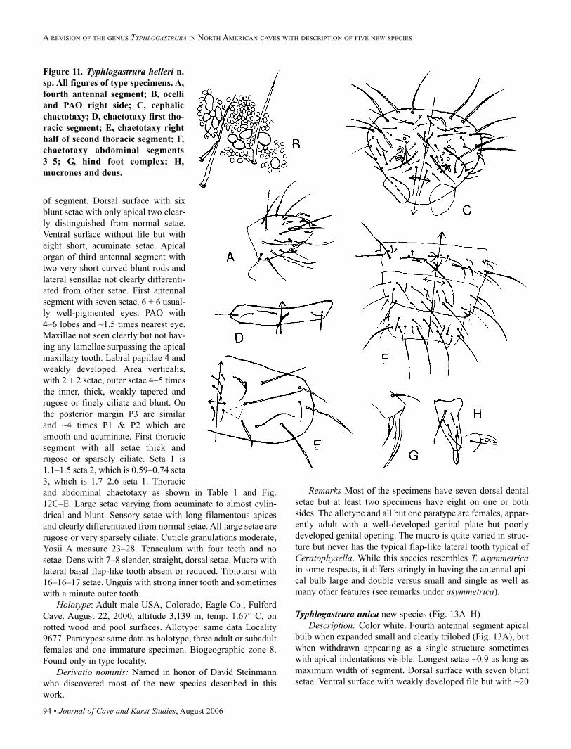
94 • Journal of Cave and Karst Studies, August 2006
of segment. Dorsal surface with six
blunt setae with only apical two clear-
ly distinguished from normal setae.
Ventral surface without file but with
eight short, acuminate setae. Apical
organ of third antennal segment with
two very short curved blunt rods and
lateral sensillae not clearly differenti-
ated from other setae. First antennal
segment with seven setae. 6 + 6 usual-
ly well-pigmented eyes. PAO with
4–6 lobes and ~1.5 times nearest eye.
Maxillae not seen clearly but not hav-
ing any lamellae surpassing the apical
maxillary tooth. Labral papillae 4 and
weakly developed. Area verticalis,
with 2 + 2 setae, outer setae 4–5 times
the inner, thick, weakly tapered and
rugose or finely ciliate and blunt. On
the posterior margin P3 are similar
and ~4 times P1 & P2 which are
smooth and acuminate. First thoracic
segment with all setae thick and
rugose or sparsely ciliate. Seta 1 is
1.1–1.5 seta 2, which is 0.59–0.74 seta
3, which is 1.7–2.6 seta 1. Thoracic
and abdominal chaetotaxy as shown in Table 1 and Fig.
12C–E. Large setae varying from acuminate to almost cylin-
drical and blunt. Sensory setae with long filamentous apices
and clearly differentiated from normal setae. All large setae are
rugose or very sparsely ciliate. Cuticle granulations moderate,
Yosii A measure 23–28. Tenaculum with four teeth and no
setae. Dens with 7–8 slender, straight, dorsal setae. Mucro with
lateral basal flap-like tooth absent or reduced. Tibiotarsi with
16–16–17 setae. Unguis with strong inner tooth and sometimes
with a minute outer tooth.
Holotype: Adult male USA, Colorado, Eagle Co., Fulford
Cave. August 22, 2000, altitude 3,139 m, temp. 1.67° C, on
rotted wood and pool surfaces. Allotype: same data Locality
9677. Paratypes: same data as holotype, three adult or subadult
females and one immature specimen. Biogeographic zone 8.
Found only in type locality.
Derivatio nominis: Named in honor of David Steinmann
who discovered most of the new species described in this
work.
Remarks Most of the specimens have seven dorsal dental
setae but at least two specimens have eight on one or both
sides. The allotype and all but one paratype are females, appar-
ently adult with a well-developed genital plate but poorly
developed genital opening. The mucro is quite varied in struc-
ture but never has the typical flap-like lateral tooth typical of
Ceratophysella. While this species resembles T. asymmetricain some respects, it differs stringly in having the antennal api-
cal bulb large and double versus small and single as well as
many other features (see remarks under asymmetrica).
Typhlogastrura unica new species (Fig. 13A–H)
Description: Color white. Fourth antennal segment apical
bulb when expanded small and clearly trilobed (Fig. 13A), but
when withdrawn appearing as a single structure sometimes
with apical indentations visible. Longest setae ~0.9 as long as
maximum width of segment. Dorsal surface with seven blunt
setae. Ventral surface with weakly developed file but with ~20
Figure 11. Typhlogastrura helleri n.
sp. All figures of type specimens. A,
fourth antennal segment; B, ocelli
and PAO right side; C, cephalic
chaetotaxy; D, chaetotaxy first tho-
racic segment; E, chaetotaxy right
half of second thoracic segment; F,
chaetotaxy abdominal segments
3–5; G, hind foot complex; H,
mucrones and dens.
A REVISION OF THE GENUS TYPHLOGASTRURA IN NORTH AMERICAN CAVES WITH DESCRIPTION OF FIVE NEW SPECIES
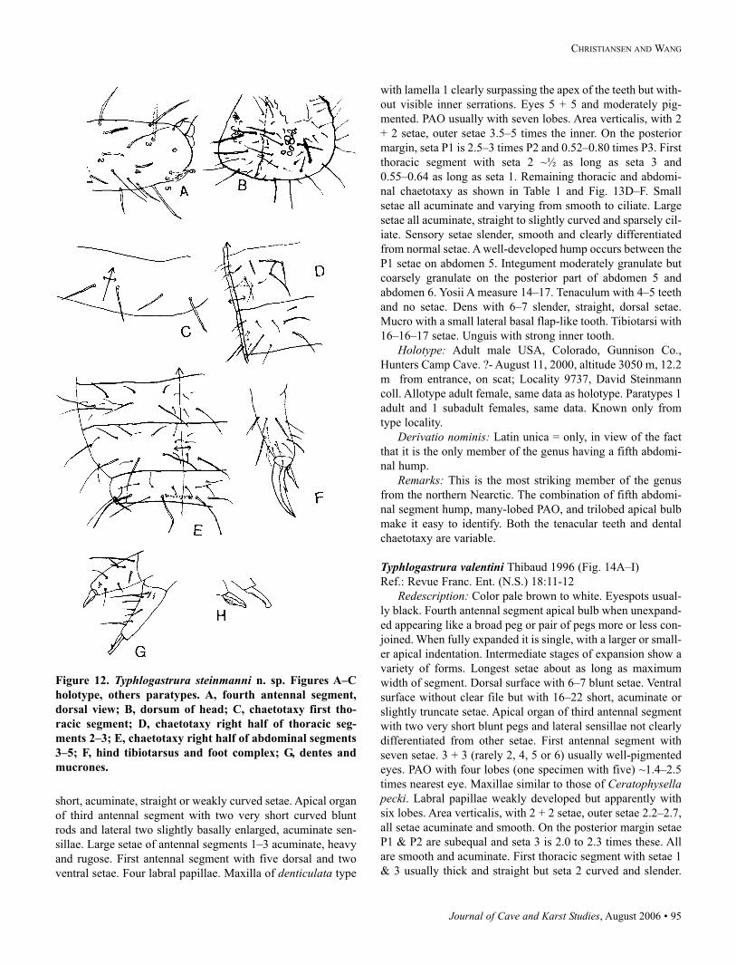
Journal of Cave and Karst Studies, August 2006 • 95
CHRISTIANSEN AND WANG
short, acuminate, straight or weakly curved setae. Apical organ
of third antennal segment with two very short curved blunt
rods and lateral two slightly basally enlarged, acuminate sen-
sillae. Large setae of antennal segments 1–3 acuminate, heavy
and rugose. First antennal segment with five dorsal and two
ventral setae. Four labral papillae. Maxilla of denticulata type
with lamella 1 clearly surpassing the apex of the teeth but with-
out visible inner serrations. Eyes 5 + 5 and moderately pig-
mented. PAO usually with seven lobes. Area verticalis, with 2
+ 2 setae, outer setae 3.5–5 times the inner. On the posterior
margin, seta P1 is 2.5–3 times P2 and 0.52–0.80 times P3. First
thoracic segment with seta 2 ~½ as long as seta 3 and
0.55–0.64 as long as seta 1. Remaining thoracic and abdomi-
nal chaetotaxy as shown in Table 1 and Fig. 13D–F. Small
setae all acuminate and varying from smooth to ciliate. Large
setae all acuminate, straight to slightly curved and sparsely cil-
iate. Sensory setae slender, smooth and clearly differentiated
from normal setae. A well-developed hump occurs between the
P1 setae on abdomen 5. Integument moderately granulate but
coarsely granulate on the posterior part of abdomen 5 and
abdomen 6. Yosii A measure 14–17. Tenaculum with 4–5 teeth
and no setae. Dens with 6–7 slender, straight, dorsal setae.
Mucro with a small lateral basal flap-like tooth. Tibiotarsi with
16–16–17 setae. Unguis with strong inner tooth.
Holotype: Adult male USA, Colorado, Gunnison Co.,
Hunters Camp Cave. ?- August 11, 2000, altitude 3050 m, 12.2
m from entrance, on scat; Locality 9737, David Steinmann
coll. Allotype adult female, same data as holotype. Paratypes 1
adult and 1 subadult females, same data. Known only from
type locality.
Derivatio nominis: Latin unica = only, in view of the fact
that it is the only member of the genus having a fifth abdomi-
nal hump.
Remarks: This is the most striking member of the genus
from the northern Nearctic. The combination of fifth abdomi-
nal segment hump, many-lobed PAO, and trilobed apical bulb
make it easy to identify. Both the tenacular teeth and dental
chaetotaxy are variable.
Typhlogastrura valentini Thibaud 1996 (Fig. 14A–I)
Ref.: Revue Franc. Ent. (N.S.) 18:11-12
Redescription: Color pale brown to white. Eyespots usual-
ly black. Fourth antennal segment apical bulb when unexpand-
ed appearing like a broad peg or pair of pegs more or less con-
joined. When fully expanded it is single, with a larger or small-
er apical indentation. Intermediate stages of expansion show a
variety of forms. Longest setae about as long as maximum
width of segment. Dorsal surface with 6–7 blunt setae. Ventral
surface without clear file but with 16–22 short, acuminate or
slightly truncate setae. Apical organ of third antennal segment
with two very short blunt pegs and lateral sensillae not clearly
differentiated from other setae. First antennal segment with
seven setae. 3 + 3 (rarely 2, 4, 5 or 6) usually well-pigmented
eyes. PAO with four lobes (one specimen with five) ~1.4–2.5
times nearest eye. Maxillae similar to those of Ceratophysellapecki. Labral papillae weakly developed but apparently with
six lobes. Area verticalis, with 2 + 2 setae, outer setae 2.2–2.7,
all setae acuminate and smooth. On the posterior margin setae
P1 & P2 are subequal and seta 3 is 2.0 to 2.3 times these. All
are smooth and acuminate. First thoracic segment with setae 1
& 3 usually thick and straight but seta 2 curved and slender.
Figure 12. Typhlogastrura steinmanni n. sp. Figures A–C
holotype, others paratypes. A, fourth antennal segment,
dorsal view; B, dorsum of head; C, chaetotaxy first tho-
racic segment; D, chaetotaxy right half of thoracic seg-
ments 2–3; E, chaetotaxy right half of abdominal segments
3–5; F, hind tibiotarsus and foot complex; G, dentes and
mucrones.
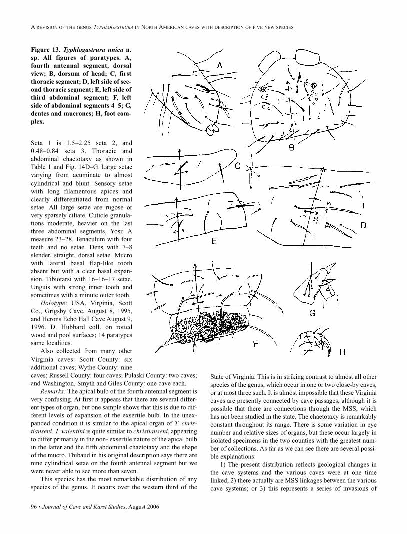
96 • Journal of Cave and Karst Studies, August 2006
Seta 1 is 1.5–2.25 seta 2, and
0.48–0.84 seta 3. Thoracic and
abdominal chaetotaxy as shown in
Table 1 and Fig. 14D–G. Large setae
varying from acuminate to almost
cylindrical and blunt. Sensory setae
with long filamentous apices and
clearly differentiated from normal
setae. All large setae are rugose or
very sparsely ciliate. Cuticle granula-
tions moderate, heavier on the last
three abdominal segments, Yosii A
measure 23–28. Tenaculum with four
teeth and no setae. Dens with 7–8
slender, straight, dorsal setae. Mucro
with lateral basal flap-like tooth
absent but with a clear basal expan-
sion. Tibiotarsi with 16–16–17 setae.
Unguis with strong inner tooth and
sometimes with a minute outer tooth.
Holotype: USA, Virginia, Scott
Co., Grigsby Cave, August 8, 1995,
and Herons Echo Hall Cave August 9,
1996. D. Hubbard coll. on rotted
wood and pool surfaces; 14 paratypes
same localities.
Also collected from many other
Virginia caves: Scott County: six
additional caves; Wythe County: nine
caves; Russell County: four caves; Pulaski County: two caves;
and Washington, Smyth and Giles County: one cave each.
Remarks: The apical bulb of the fourth antennal segment is
very confusing. At first it appears that there are several differ-
ent types of organ, but one sample shows that this is due to dif-
ferent levels of expansion of the exsertile bulb. In the unex-
panded condition it is similar to the apical organ of T. chris-tianseni. T. valentini is quite similar to christianseni, appearing
to differ primarily in the non- exsertile nature of the apical bulb
in the latter and the fifth abdominal chaetotaxy and the shape
of the mucro. Thibaud in his original description says there are
nine cylindrical setae on the fourth antennal segment but we
were never able to see more than seven.
This species has the most remarkable distribution of any
species of the genus. It occurs over the western third of the
State of Virginia. This is in striking contrast to almost all other
species of the genus, which occur in one or two close-by caves,
or at most three such. It is almost impossible that these Virginia
caves are presently connected by cave passages, although it is
possible that there are connections through the MSS, which
has not been studied in the state. The chaetotaxy is remarkably
constant throughout its range. There is some variation in eye
number and relative sizes of organs, but these occur largely in
isolated specimens in the two counties with the greatest num-
ber of collections. As far as we can see there are several possi-
ble explanations:
1) The present distribution reflects geological changes in
the cave systems and the various caves were at one time
linked; 2) there actually are MSS linkages between the various
cave systems; or 3) this represents a series of invasions of
Figure 13. Typhlogastrura unica n.
sp. All figures of paratypes. A,
fourth antennal segment, dorsal
view; B, dorsum of head; C, first
thoracic segment; D, left side of sec-
ond thoracic segment; E, left side of
third abdominal segment; F, left
side of abdominal segments 4–5; G,
dentes and mucrones; H, foot com-
plex.
A REVISION OF THE GENUS TYPHLOGASTRURA IN NORTH AMERICAN CAVES WITH DESCRIPTION OF FIVE NEW SPECIES
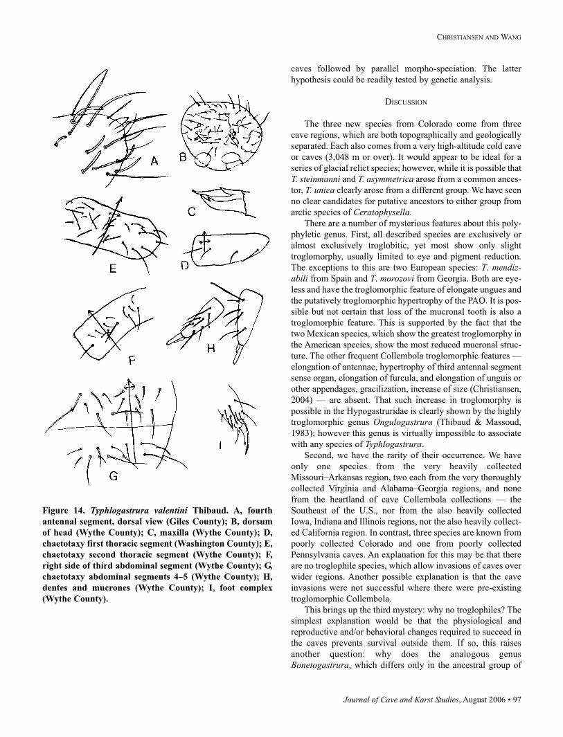
Journal of Cave and Karst Studies, August 2006 • 97
CHRISTIANSEN AND WANG
caves followed by parallel morpho-speciation. The latter
hypothesis could be readily tested by genetic analysis.
DISCUSSION
The three new species from Colorado come from three
cave regions, which are both topographically and geologically
separated. Each also comes from a very high-altitude cold cave
or caves (3,048 m or over). It would appear to be ideal for a
series of glacial relict species; however, while it is possible that
T. steinmanni and T. asymmetrica arose from a common ances-
tor, T. unica clearly arose from a different group. We have seen
no clear candidates for putative ancestors to either group from
arctic species of Ceratophysella.There are a number of mysterious features about this poly-
phyletic genus. First, all described species are exclusively or
almost exclusively troglobitic, yet most show only slight
troglomorphy, usually limited to eye and pigment reduction.
The exceptions to this are two European species: T. mendiz-abili from Spain and T. morozovi from Georgia. Both are eye-
less and have the troglomorphic feature of elongate ungues and
the putatively troglomorphic hypertrophy of the PAO. It is pos-
sible but not certain that loss of the mucronal tooth is also a
troglomorphic feature. This is supported by the fact that the
two Mexican species, which show the greatest troglomorphy in
the American species, show the most reduced mucronal struc-
ture. The other frequent Collembola troglomorphic features —
elongation of antennae, hypertrophy of third antennal segment
sense organ, elongation of furcula, and elongation of unguis or
other appendages, gracilization, increase of size (Christiansen,
2004) — are absent. That such increase in troglomorphy is
possible in the Hypogastruridae is clearly shown by the highly
troglomorphic genus Ongulogastrura (Thibaud & Massoud,
1983); however this genus is virtually impossible to associate
with any species of Typhlogastrura.
Second, we have the rarity of their occurrence. We have
only one species from the very heavily collected
Missouri–Arkansas region, two each from the very thoroughly
collected Virginia and Alabama–Georgia regions, and none
from the heartland of cave Collembola collections — the
Southeast of the U.S., nor from the also heavily collected
Iowa, Indiana and Illinois regions, nor the also heavily collect-
ed California region. In contrast, three species are known from
poorly collected Colorado and one from poorly collected
Pennsylvania caves. An explanation for this may be that there
are no troglophile species, which allow invasions of caves over
wider regions. Another possible explanation is that the cave
invasions were not successful where there were pre-existing
troglomorphic Collembola.
This brings up the third mystery: why no troglophiles? The
simplest explanation would be that the physiological and
reproductive and/or behavioral changes required to succeed in
the caves prevents survival outside them. If so, this raises
another question: why does the analogous genus
Bonetogastrura, which differs only in the ancestral group of
Figure 14. Typhlogastrura valentini Thibaud. A, fourth
antennal segment, dorsal view (Giles County); B, dorsum
of head (Wythe County); C, maxilla (Wythe County); D,
chaetotaxy first thoracic segment (Washington County); E,
chaetotaxy second thoracic segment (Wythe County); F,
right side of third abdominal segment (Wythe County); G,
chaetotaxy abdominal segments 4–5 (Wythe County); H,
dentes and mucrones (Wythe County); I, foot complex
(Wythe County).
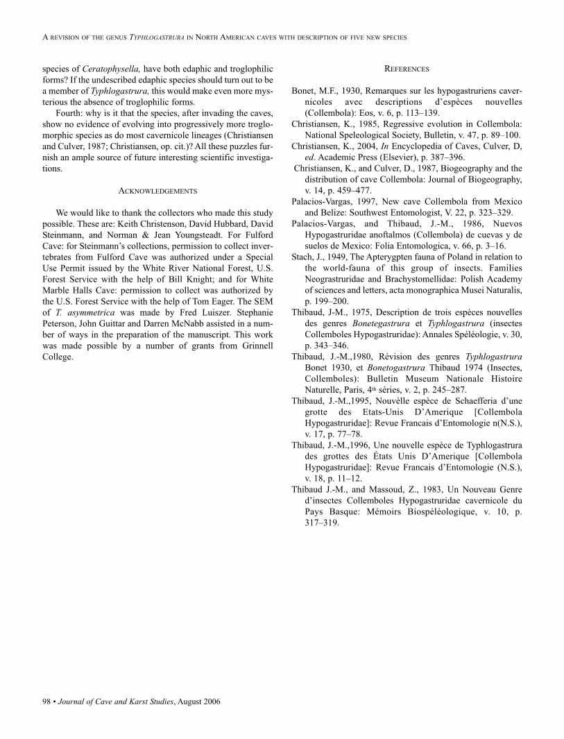
98 • Journal of Cave and Karst Studies, August 2006
species of Ceratophysella, have both edaphic and troglophilic
forms? If the undescribed edaphic species should turn out to be
a member of Typhlogastrura, this would make even more mys-
terious the absence of troglophilic forms.
Fourth: why is it that the species, after invading the caves,
show no evidence of evolving into progressively more troglo-
morphic species as do most cavernicole lineages (Christiansen
and Culver, 1987; Christiansen, op. cit.)? All these puzzles fur-
nish an ample source of future interesting scientific investiga-
tions.
ACKNOWLEDGEMENTS
We would like to thank the collectors who made this study
possible. These are: Keith Christenson, David Hubbard, David
Steinmann, and Norman & Jean Youngsteadt. For Fulford
Cave: for Steinmann’s collections, permission to collect inver-
tebrates from Fulford Cave was authorized under a Special
Use Permit issued by the White River National Forest, U.S.
Forest Service with the help of Bill Knight; and for White
Marble Halls Cave: permission to collect was authorized by
the U.S. Forest Service with the help of Tom Eager. The SEM
of T. asymmetrica was made by Fred Luiszer. Stephanie
Peterson, John Guittar and Darren McNabb assisted in a num-
ber of ways in the preparation of the manuscript. This work
was made possible by a number of grants from Grinnell
College.
REFERENCES
Bonet, M.F., 1930, Remarques sur les hypogastruriens caver-
nicoles avec descriptions d’espèces nouvelles
(Collembola): Eos, v. 6, p. 113–139.
Christiansen, K., 1985, Regressive evolution in Collembola:
National Speleological Society, Bulletin, v. 47, p. 89–100.
Christiansen, K., 2004, In Encyclopedia of Caves, Culver, D,
ed. Academic Press (Elsevier), p. 387–396.
Christiansen, K., and Culver, D., 1987, Biogeography and the
distribution of cave Collembola: Journal of Biogeography,
v. 14, p. 459–477.
Palacios-Vargas, 1997, New cave Collembola from Mexico
and Belize: Southwest Entomologist, V. 22, p. 323–329.
Palacios-Vargas, and Thibaud, J.-M., 1986, Nuevos
Hypogastruridae anoftalmos (Collembola) de cuevas y de
suelos de Mexico: Folia Entomologica, v. 66, p. 3–16.
Stach, J., 1949, The Apterygpten fauna of Poland in relation to
the world-fauna of this group of insects. Families
Neograstruridae and Brachystomellidae: Polish Academy
of sciences and letters, acta monographica Musei Naturalis,
p. 199–200.
Thibaud, J-M., 1975, Description de trois espèces nouvelles
des genres Bonetegastrura et Typhlogastrura (insectes
Collemboles Hypogastruridae): Annales Spéléologie, v. 30,
p. 343–346.
Thibaud, J.-M.,1980, Révision des genres TyphlogastruraBonet 1930, et Bonetogastrura Thibaud 1974 (Insectes,
Collemboles): Bulletin Museum Nationale Histoire
Naturelle, Paris, 4th séries, v. 2, p. 245–287.
Thibaud, J.-M.,1995, Nouvèlle espèce de Schaefferia d’une
grotte des Etats-Unis D’Amerique [Collembola
Hypogastruridae]: Revue Francais d’Entomologie n(N.S.),
v. 17, p. 77–78.
Thibaud, J.-M.,1996, Une nouvelle espèce de Typhlogastrura
des grottes des États Unis D’Amerique [Collembola
Hypogastruridae]: Revue Francais d’Entomologie (N.S.),
v. 18, p. 11–12.
Thibaud J.-M., and Massoud, Z., 1983, Un Nouveau Genre
d’insectes Collemboles Hypogastruridae cavernicole du
Pays Basque: Mémoirs Biospéléologique, v. 10, p.
317–319.
A REVISION OF THE GENUS TYPHLOGASTRURA IN NORTH AMERICAN CAVES WITH DESCRIPTION OF FIVE NEW SPECIES
Journal of Cave and Karst Studies, August 2006 • 99
KARST SCIENCE REVIEWS
ACTA CARSOLOGICA 2005Issue 34 (3)
Preface. Salbe, T., 539–540.
Towards a special issue of Acta Carsologica. Mulec, J.,
541–542.
Intermittent lakes in the Pivka Basin. Mulec, J., Mihevc, A.
and Pipan, T., 543–565.
Tectonic sights of the Pivka Basin. Šebela, S., 566–581.
Lithostratigraphic characteristics of the intermittent Pivka
lakes region and Matijeva jama cave estavelle. Knez, M. and
Slabe, T., 582–598.
Hydrogeological characteristics of the area of intermittent
karst lakes of Pivka. Petrič M. and Kogovšek, J., 599–618.
Intermittent karst lakes of the Pivka basin (SW Slovenia) dur-
ing high waters in November 2000. Kovačič, G. and Habič, Š,
619–649.
Fauna of the Pivka intermittent lakes. Pipan, T., 650–659.
Fauna of the land habitats of the Pivka lakes. Polak, S.,
660–690.
Tabor above Zagorje – Šilentabor, archaeological rescue sam-
ple trenching in the area of the castle complex. Bratina, P.,
691–767.
The strategic position of upper Pivka and the intermittent lakes
after implementation of the Rapallo Treaty. Čuček, M.,
768–783.
Living with the lake, living without the lake. An introduction
into the research of the way of life by the intermittent karstic
lakes Petelinsko Jezero and Palško Jezero. Erjavec, M. and
Peršič, M., 784–814.
Intermittent lakes of the upper Pivka — Protection in time.
Cernatič-Gregorič, A. and Gorkič, M., 815–828.
WORLD KARST SCIENCE REVIEWS
100 • Journal of Cave and Karst Studies, August 2006
INTERNATIONAL JOURNAL OF SPELEOLOGY 2006Issue 35 (2)
Thermal variations in the hyporheic zone of a karst stream.
Dogwiler, T. and Wicks, C., 59–66.
Vashegyite from Gaura cu Muscă Cave. Bogdan, O.P.,
Luminiţa, Z., Kearns. J. and Veres, D., 67–73.
Studies of condensation/evaporation processes in the
Glowworm Cave, New Zealand. de Freitas, C.R. and
Schmekal, A.A., 75–81.
The distribution of diatom flora in ice caves of the northern
Yukon Territory, Canada: relationship to air circulation and
freezing. Lauriol, B., Prévost, C. and Lacelle, D., 83–92.
Radon in caves: Clinical aspects. Craven, S.A. and Smit, B.J.,93–101.
Identification of cave minerals by Raman spectroscopy: New
technology for non-destructive analysis. White, W.B.,103–107.
KARST SCIENCE REVIEWS
SUBTERRANEAN BIOLOGYVol. 3
Evolution of eye degeneration in cavefish: the return of
pleiotropy. Jeffery W.R.
Conservation of sub-terranean biodiversity in Western
Australia: using molecular genetics to define spatial and tem-
poral relationships in two species of cave-dwelling
Amphipoda. Eberhard S., Leys R., and Adams M.
Stygofauna associated with springfauna in southern Poland.
Dumnicka E.
The cave crickets of Far East: a contribution to the study of
East-Asian Rhaphidophoridae diversity (Orthoptera). Di
Russo C. and Rampini M.
Preliminary data on locomotor activity rhythms of epigean and
cave snails, genus Potamolithus (Hydrobiidae), from south-
eastern Brazil. Bichuette M.E. and Menna-Barreto L.
Locomotor activity in Dolichopoda cave crickets. A chronobi-
ological study of populations from natural and artificial caves.
Pasquali V., Renzi P., Lucarelli M. and Sbordoni V.
Imperfect signal transmission and female mate choice in sur-
face- and cave-dwelling Atlantic mollies, Poecilia mexicana(Poeciliidae, Teleostei). Plath M., Körner K.E., Möller A. and
Schlupp I.
Journal of Cave and Karst Studies, August 2006 • 101
AUTHORS
KARSTOLOGIA 472006
Marian Pulina (1936-2005), créateur de l’Ecole polonaise de karstologie. Tyc, Andrzej, 1–3.
Marian Pulina: Plus de 40 ans de relations scientifiques entre la Pologne et la France. Nicod, Jean and Salomon, Jean-Noël, 3–6.
Intérêt des sédiments détritiques endokarstiques en tant qu’archive naturelle?
Discussion autour des dépôts lacustres souterrains (Grottes de Choranche - Vercors). Perroux, Anne-Sophie, 7–20.
Morphologie et remplissage des dolines du Causse de Martel d’après les observations réalisées au cours du diagnostic
archéologique de l’aérodrome de Brive-Souillac (Corrèze et Lot). Bruxelles, Laurent, Colonge, David, and Salgues, Thierry,
21–32.
Phénomènes karstiques et tourisme dans les parcs nationaux de l’Ouest canadien: La mise en valeur progressive d’un patrimoine
naturel. Héritier, Stéphane, 33–48.
Evolution actuelle des phénomènes karstiques dans la Cordillera de la Sal (Atacama, Nord Chili). Sesiano, Jean, 49–54.
Influence of visual and chemical cues on the aggregation
behavior of Pyrenean mountain newts, Euproctus asper(Urodela, Salamandridae). Poschadel J. R., Rudolph A.,
Warbeck A., and Plath M.
Comments about stenasellids (Crustacea, Isopoda, Asellota) of
underground waters in Asia. Magniez G.J.
A new Stenasellidae from underground waters of Thailand:
Stenasellus mongnatei, sp. nov. (Crustacea, Isopoda, Asellota).
Magniez G.J. and Panitvong N.
A new species of Arrhopalites (Collembola, Symphypleona,
Arrhopalitidae) from a cave on the Central East Iberian
Peninsula. Baquero E., Herrando-Pérez S., and Jordana R.
The genus Espanoliella Guéorguiev, 1976. E. luquei, sp. nov.
(Coleoptera: Leiodidae: Leptodirinae). Salgado J.M. and
Fresneda J.
Book review: Culver D.C.– Whiter Epikarst?
Report: Pati A.K., Joshi B.N., Parganiha A. – Improving
Biospeleology in India.
New taxa described in this volume.

NSS Books–For You or a Gift for a Friend New! Full Color–Children’s Book
The Hidden World of Caves
� � � � � � � � � � � � � � � � � � �
Ronal C. Kerbo
Caving BasicsA Comprehensive Guide
for Beginning Cavers
G. Thomas Rea, Editor
Now in its third edition,this popular book coverseverything the beginningcaver needs to knowabout exploring theunderground wildernesssafely and responsibly.
Includes complete data on the latesttechniques and equipment, plus definitivechapters on cave sciences: geology, biology,and archaeology.
This book is an ideal starting point forbeginning cavers.Paperback, 188 p. $ 11. Member $ 10.
Cave Minerals of the World
Beautifully illustratedin full color withnearly 300 colorphotos, this bookdescribes all of theworld’s 255 knowncave minerals.
Written in crisp,easy to read text,readers from allbackgrounds will beenchanted to discover the delicate beautyand diversity found in the silent darknessof the underground wilderness.Hardback, full color, 464 p.NEW LOWER PRICE $ 45
SpeleogenesisEvolution of Karst Aquifers
A.B. Klimchouk, D.C. Ford, A.N.Palmer, and W. Dreybrodt, Editors
On Call A Complete Reference for Cave Rescue
� � � � � � � � � � � � � � � � � � � �John C. Hempel and AnnetteFregeau-Conover, Editors
This book is a pioneerattempt by an interna-tional group of cavescientists to: • Summarizemodern knowledgeabout the origin of cavesin various settings. • Ex-amine the variety ofapproaches adopted.• Outline the role of
Brings together theknowledge and expe-riences accumulatedby cave rescuers dur-ing 50 years of rescuein the caves of theAmericas. It is intendedto serve as a compre-
ON STATION
George Dasher
ON ROPENorth American
Vertical Rope Techniques� � � � � � � � � � � � � � � � �
Bruce Smith and Allen Padgett
as the most authoritative book on single ropetechniques (SRT). Heavily illustrated, it coversin detail: ropes, knots, rigging, harnesses,rappelling, ascending, and belaying. Includes acomplete training program.Hardback, 382 p. $ 32. Member $ 30.
For: • Caving • Searchand Rescue • Firefight-ing • Rope Rescue • RockClimbing • Mountain-eering • Window Clean-ing • Arborists• Event Rigging.On Rope has gainedworldwide recognition
New
Price
$45
hensive reference for those involved incave rescue. It can also serve as a fieldguide for rescue squads and Search andRescue (SAR) teams, who are occa-sionally called on to work within a cave.Hardback and paperback, 384 p. $ 35and $ 27. Member $ 33 and $ 25.
First it shows how to collect com-plete and accurate survey data, thenhow to draft a precise and attractivecave map ready for reproduction.Hardback, 248 p. $ 17. Member $ 16
This full-color book isan introduction to cavesfor children and youngadults.
It asks: When youhear the word cave,what comes to mind?Darkness? Mystery?A scary place? Bats? Snakes? Arecaves important? What are they usedfor? Are they dangerous?
As you read this book, we hopeyou’ll discover the answers to thesequestions and more, in the hidden worldbeneath the earth.Paperback, full color, 48 p. $ 10.Member $9.00.
Dunbar CaveThe Showplace of the South� � � � � � � � � � � � � � � � �
Larry E. Matthews
NEW!
On Caves and Cameras
� � � � � � � � � � � � � � � �
Norman R. Thompson andJohn Van Swearingen IV
NEW!
speleogenesis in karst aquifer evolution.Hardback, 528 p. $ 60. Member $ 56.
Written by many of the NSS’sleading cave photographers,On Caves and Cameras iscopiously illustrated withphotographs and drawings. Itincludes a gallery of stunningcolor images, plus information about howeach photograph was taken.Hardback, 336 p. $ 38. Member $ 35.
• Dunbar Cave—first explored8,000 years ago by NativeAmericans—is now one ofAmerica’s major caves.
• Share the excitement as caveexplorers and scuba diversdiscover miles of new passage in a cavealready thoroughly explored for 150 years.
Paperback, 146 p. $16. Member $15.
� � � � � � � � � � � � � � �� � � � �
� � � � � � � �
This book coverseverything boththe beginning andexperienced cavesurveyor needs toknow aboutsurveying andmapping caves.
� � � � � � � � � � � � � � � � �
Carol Hill and Paolo Forti � � � � � � � � � � � � � � � � �
Speleo Digest� � � � � � � � � �
The Best-of-the-Best from GrottoNewsletters–Each and EveryYear• Cave descriptionsand maps • Detailedexploration stories• Techniques • Equip-ment • History • Fic-tion. • Humor • Art .
Member Prices: • 2002 $19.• 2001 $23 • 2000, 1999, 1998, 1994 $19.• 1993 $7.50 • 1992, 1991, 1990 $ 19 • 1989(reprint) $61 (only 23 left). 1988 $19. 1986, 1984,1983 $7.50 • 1980, 1978, 1977 only $ 2.50
Speleo Digest
National Speleological Society
Years still available:2002, 2001, 2000,1999, 1998, 1994,1993, 1992, 1991,1990, 1989, 1983,1982, 1980, 1988,1986, 1984, 19831980, 1978, 1977
NOW: Order on line at: http:// www. caves.org/service/bookstore or 256-852-1300
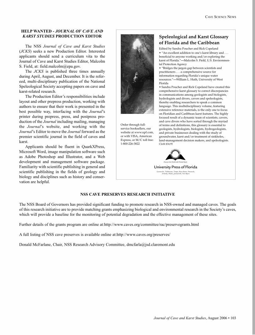
Journal of Cave and Karst Studies, August 2006 • 103
CAVE SCIENCE NEWS
HELP WANTED - JOURNAL OF CAVE ANDKARST STUDIES PRODUCTION EDITOR
The NSS Journal of Cave and Karst Studies(JCKS) seeks a new Production Editor. Interested
applicants should send a curriculum vita to the
Journal of Cave and Karst Studies Editor, Malcolm
S. Field, at: [email protected].
The JCKS is published three times annually
during April, August, and December. It is the refer-
eed, multi-disciplinary publication of the National
Speleological Society accepting papers on cave and
karst-related research.
The Production Editor’s responsibilities include
layout and other prepress production, working with
authors to ensure that their work is presented in the
best possible way, interfacing with the Journal’sprinter during prepress, press, and postpress pro-
duction of the Journal including mailing, managing
the Journal’s website, and working with the
Journal’s Editor to move the Journal forward as the
premier scientific journal in the field of caves and
karst.
Applicants should be fluent in QuarkXPress,
Microsoft Word, image manipulation software such
as Adobe Photoshop and Illustrator, and a Web
development and management software package.
Familiarity with scientific publishing in general and
scientific publishing in the fields of geology and
biology and disciplines such as history and conser-
vation are helpful.
NSS CAVE PRESERVES RESEARCH INITIATIVE
The NSS Board of Governors has provided significant funding to promote research in NSS-owned and managed caves. The goals
of this research initiative are to provide matching grants emphasizing biological and environmental research in the Society’s caves,
which will provide a baseline for the monitoring of potential degradation and the effective management of these sites.
Further details of the grants program are online at:http://www.caves.org/committee/rac/preservegrants.html
A full listing of NSS cave preserves is available online at:http://www.caves.org/preserves/
Donald McFarlane, Chair, NSS Research Advisory Committee, [email protected]
Gainesville, Tallahassee, Tampa, Boca Raton, Pensacola,Orlando, Miami, Jacksonville, Fort Myers
University Press of Florida
Speleological and Karst Glossaryof Florida and the CaribbeanEdited by Sandra Poucher and Rick Copeland• “An excellent addition to one’s karst library and . . .beneficial to anyone working and/or exploring thekarst of Florida.”—Malcolm S. Field, U.S. Environmen-tal Protection Agency• “Bridges the jargon gap between scientists andpractitioners . . . a comprehensive source forinformation regarding Florida’s unique waterresources.”—William L. Huth, University of WestFlorida• Sandra Poucher and Rick Copeland have created thiscomprehensive karst glossary to correct discrepanciesin communications among geologists and biologists,hydrologists and divers, cavers and speleologists,thereby enabling researchers to speak a commonlanguage. This multidisciplinary volume, featuringextensive reference materials, is the only one to focuson Floridian and Caribbean karst features. The highlyfocused result of a dynamic team of scientists, cavers,and cave divers who have sorted through the myriadof terms and definitions, this glossary is essential togeologists, hydrologists, biologists, hydrogeologists,and private businesses dealing with the study ofgroundwater, karst and/or treatment of sinkholes,land-management decision makers, and speleologists.Cloth $34.95
Discover the World with Florida Books
Order through full-service booksellers, ourwebsite at www.upf.com,or with VISA, AmericanExpress, or M/C toll free:1-800-226-3822
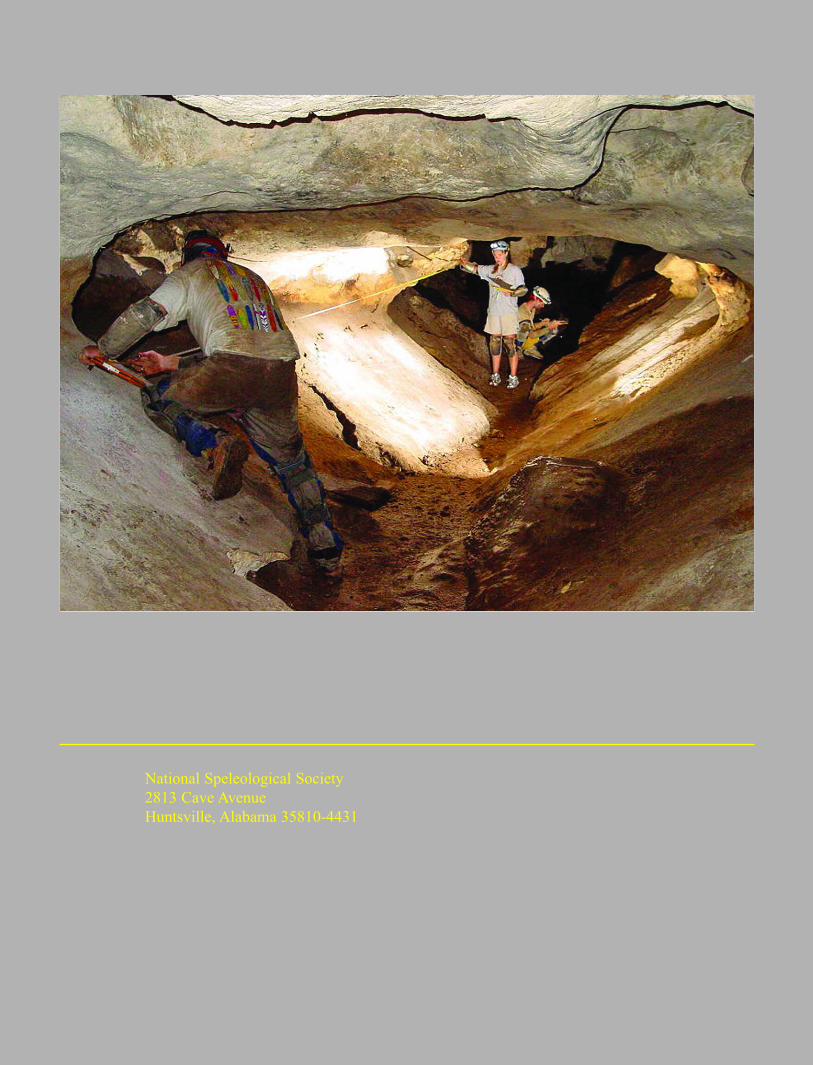
National Speleological Society
2813 Cave Avenue
Huntsville, Alabama 35810-4431