Embed Size (px)
Citation preview
Journal of Volcanology and Geothermal Research 280 (2014) 53–66
Contents lists available at ScienceDirect
Journal of Volcanology and Geothermal Research
j ourna l homepage: www.e lsev ie r .com/ locate / jvo lgeores
A newly-emerged (August 2013) artificially-triggered fumarole near theFiumicino airport, Rome, Italy
Pio Sella a, Andrea Billi b,⁎, Ilaria Mazzini b,c, Luigi De Filippis c, Luca Pizzino d,Alessandra Sciarra d, Fedora Quattrocchi d
a Geomagellan, Montecompatri, Rome, Italyb Consiglio Nazionale delle Ricerche, IGAG, Rome, Italyc Dipartimento di Scienze, Università Roma Tre, Rome, Italyd Istituto Nazionale di Geofisica e Vulcanologia, Rome, Italy
⁎ Corresponding author at: CNR-IGAG at DipartimentoSapienza, Piazzale A. Moro 5, Rome 00185, Italy. Tel.: +39
E-mail address: [email protected] (A. Billi).
http://dx.doi.org/10.1016/j.jvolgeores.2014.05.0080377-0273/© 2014 Elsevier B.V. All rights reserved.
a b s t r a c t
a r t i c l e i n f oArticle history:Received 20 November 2013Accepted 6 May 2014Available online 14 May 2014
Keywords:FumaroleMud volcanoGas hazardDrillingRome
Early in the morning of 24 August, 2013, following by hours the drilling of a shallow borehole in the same spot, anew fumarole producing emissions of CO2-rich gas, water, and mud suddenly appeared at a crossroad along thefenced area of the Fiumicino international airport of Rome, Italy. Similar episodes have been scientifically docu-mented or simply reported in recent and past years. To understandwhy gases are easily entrapped in the shallowsubsurface of the Fiumicino area, we usedfive borehole cores drilled by us, analyzed the stratigraphy of these andother nearby cores, acquired a 2D seismic refraction tomogram, and performed chemical and isotopic analyses ofwater samples collected from aquifers intercepted by two drilled boreholes. Our boreholes were realized withproper anti-gasmeasures as, while drilling,we recorded the presence of pressurized gases at a specific permeablegravel level. Results show that, in the study area, gases becomemainly entrapped in amid-Pleistocene gravel ho-rizon at about 40–50 m depth. This horizon contains a confined aquifer that stores the endogenous upwellinggases. The gravel is interposed between two silty–clayey units. The lower unit, very hard and overconsolidated,is affected by fractures that allow ascending gases to bypass the otherwise impermeable shale, permeate thegravel, and dissolve into the aquifer. In contrast, the upper unit is impermeable to fluids and seals the gas-pressurized aquifer, which therefore constitutes a source of hazard during human activities such as well drilling,quarrying, and various building-related excavations. As the stratigraphy of the Fiumicino area is very common inlarge portions of the densely populated Roman area and as the adjacent volcanic districts are hydrothermallyactive, we conclude that phenomena similar to that observed at Fiumicino could again occur both at Fiumicinoand elsewhere in the surrounding region. As a prompt confirmation of our conclusion, we signal that, whilewriting this paper, new artificially-triggered degassing phenomena occurred off Fiumicino in connection withthe construction of the new harbor.
© 2014 Elsevier B.V. All rights reserved.
1. Introduction
Suddenly on the early morning of 24 August 2013, a fumaroleproducing emissions of gas (mainly CO2), cold water (c. 20 °C), andmud appeared at a crossroad along the fenced area of the Fiumicino in-ternational airport of Rome, Italy (Figs. 1 and 2; SupplementalMaterials1 to 3; Ciotoli et al., 2013; Pantaloni and Argentieri, 2013). Forweeks thefumarole has continued its emissions, forming, at times, a small mudvolcano (Fig. 2). The emissions have then slightly decreased and arestill active at the time of writing (November 2013). Similar structuresare well known as volcanic or endogenous manifestations worldwideincluding Iceland, Italy, Japan, and Yellowstone and Salton Sea in the
Scienze della Terra, Università06 4991 4955.
USA, and are potentially hazardous when occurring in or close toinhabited areas both for the emitted lethal gases and for other connect-ed phenomena such as mudflows (Werner et al., 2000; Hanningtonet al., 2001; Kopf, 2002; Patrick et al., 2004; Manga and Brodsky, 2006;Barberi et al., 2007; Caliro et al., 2007; Etiope et al., 2007; Giammancoet al., 2007; Ohba et al., 2007; Mazzini, 2009; Chiodini et al., 2012).
The city of Rome is located in the Tyrrhenian (western) side of thecentral Italian peninsula (Fig. 1). This area constitutes the rear of theCenozoic–Quaternary east-verging Apennines fold-and-thrust belt andhas been stretched by backarc and postorogenic processes since middleMiocene time (Brogi and Liotta, 2008; Barchi, 2010; Brogi, 2011). In thisregion, a shallowMoho (Fig. 1a), Quaternary extensional basins and vol-canoes, and high heat and deep CO2 fluxes are the main symptoms ofthe Quaternary-to-present stretching processes (Peccerillo, 1985;Malinverno and Ryan, 1986; Sartori and ODP LEG 107 Scientific Staff,1989; Mongelli and Zito, 1991; Faccenna et al., 1994a; Cavinato and

Fig. 1. (a) Depth to theMohorovičić discontinuity (Moho) in Italy and surrounding areas (after Dèzes and Ziegler, 2002). Numbers in the map areMoho depth in kilometers. The crust ofthe Tyrrhenian (western) side of the Italian peninsula (where Fiumicino is located) has been stretched and thinned by postorogenic processes. The Tyrrhenian basin iswhere the thinnestcrust of western Europe–Mediterranean occurs. (b) Geological setting of the Roman area dominated by the Tiber River valley (Roman basin) and two adjacent large volcanic districts ofQuaternary age: the Sabatini district toward the northwest and the Colli Albani district toward the southeast. The study area (Fiumicino) is located on the Tiber River delta along theTyrrhenian coast. (c) Three-dimensional diagram showing the Colli Albani subsurface geological structure (after De Rita et al., 1988, modified by Giordano et al., 2013). See the Fiumicinoarea located on the Tiber River delta.
54 P. Sella et al. / Journal of Volcanology and Geothermal Research 280 (2014) 53–66
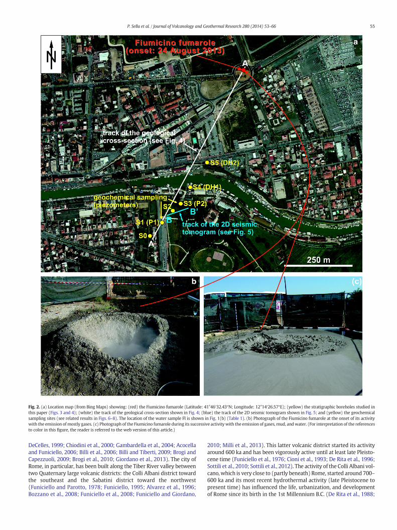
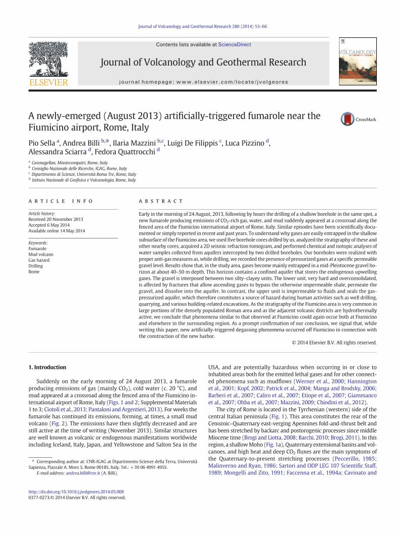
Fig. 2. (a) Location map (from Bing Maps) showing: (red) the Fiumicino fumarole (Latitude: 41°46′32.43″N; Longitude: 12°14′26.57″E); (yellow) the stratigraphic boreholes studied inthis paper (Figs. 3 and 4); (white) the track of the geological cross-section shown in Fig. 4; (blue) the track of the 2D seismic tomogram shown in Fig. 5; and (yellow) the geochemicalsampling sites (see related results in Figs. 6–8). The location of the water sample FI is shown in Fig. 1(b) (Table 1). (b) Photograph of the Fiumicino fumarole at the onset of its activitywith the emission of mostly gases. (c) Photograph of the Fiumicino fumarole during its successive activity with the emission of gases, mud, andwater. (For interpretation of the referencesto color in this figure, the reader is referred to the web version of this article.)
55P. Sella et al. / Journal of Volcanology and Geothermal Research 280 (2014) 53–66
DeCelles, 1999; Chiodini et al., 2000; Gambardella et al., 2004; Acocellaand Funiciello, 2006; Billi et al., 2006; Billi and Tiberti, 2009; Brogi andCapezzuoli, 2009; Brogi et al., 2010; Giordano et al., 2013). The city ofRome, in particular, has been built along the Tiber River valley betweentwo Quaternary large volcanic districts: the Colli Albani district towardthe southeast and the Sabatini district toward the northwest(Funiciello and Parotto, 1978; Funiciello, 1995; Alvarez et al., 1996;Bozzano et al., 2008; Funiciello et al., 2008; Funiciello and Giordano,
2010; Milli et al., 2013). This latter volcanic district started its activityaround 600 ka and has been vigorously active until at least late Pleisto-cene time (Funiciello et al., 1976; Cioni et al., 1993; De Rita et al., 1996;Sottili et al., 2010; Sottili et al., 2012). The activity of the Colli Albani vol-cano, which is very close to (partly beneath) Rome, started around 700–600 ka and its most recent hydrothermal activity (late Pleistocene topresent time) has influenced the life, urbanization, and developmentof Rome since its birth in the 1st Millennium B.C. (De Rita et al., 1988;

56 P. Sella et al. / Journal of Volcanology and Geothermal Research 280 (2014) 53–66
Karner et al., 2001; Giordano et al., 2006; Marra et al., 2009; Funicielloand Giordano, 2010; Gioia et al., 2010). At present, the Colli Albanivolcano is classified as quiescent for its numerous recent and historicalhydrothermal manifestations including a few episodes, duringHolocene and historical times, of maar lake withdrawals with convec-tive rollover of the lake water down over the caldera flank toward theactual city of Rome (Funiciello et al., 2002, 2003; Giordano et al., 2002;Giaccio et al., 2007; De Benedetti et al., 2008).
Active hydrothermal springs and related deposits are numerous allover the large Roman area (Barbieri et al., 1979; Maiorani et al., 1992;Minissale et al., 1997; Quattrocchi and Calcara, 1998; Chiodini andFrondini, 2001; Minissale et al., 2002; Billi et al., 2007; Voltaggio andSpadoni, 2007; Chiodini et al., 2008; Faccenna et al., 2008; Cinti et al.,2011; De Filippis et al., 2013a,b; Quattrocchi et al., 2013). Gas, steam,and fire emission, rumbling, noises, increase of water temperature,and several other hydrological and hydrothermal manifestations havebeen documented by historical sources for the Colli Albani volcano dur-ing historical times (Funiciello et al., 2002, 2003; Tuccimei et al., 2006).In the last years, accidental gas blowouts have occurred during shallowwell drillings in the western sector of the volcano and also in the Fiumi-cino area (Barberi et al., 2007), showing the presence of gas pressurizedaquifers confined under shallow impermeable horizons (Chiodini andFrondini, 2001; Pizzino et al., 2002; Annunziatellis et al., 2003;Beaubien et al., 2003; Carapezza and Tarchini, 2007; Carapezza et al.,2012). Thesemanifestations are potentially dangerous for the emissionsof lethal gases including H2S and CO2, this latter gas being always one ofthe fundamental components of these emissions (Gambardella et al.,2004). It follows that understanding the subsurface geological settingwhere these manifestations occur is the prerequisite to know thecause and mechanism of gas manifestations and, ultimately, to preventthese manifestations or at least to attenuate their consequences. Ofparticular relevance is to understand the geological reasons that leadendogenous gases to accumulate in the shallow subsurface, wherethese gases constitute a source of hazard during human activities suchas well drilling, quarrying, and various building-related excavations(e.g., Barberi et al., 2007).
At the time of the Fiumicino fumarole first emergence (24 August,2013), one of us (P.S.) was conducting a stratigraphic and geophysicalcampaign in an area close to the fumarole (Fig. 2). Below, we presentthese data to contribute to the understanding of the geological-stratigraphic setting in which the newly emerged fumarole has oc-curred. We have also sampled the shallow aquifers from two drilledwells in the study area to determine the origin of both waters and dis-solved carbon (i.e., CO2). These latter data have been compared withC-isotopes from the CO2 emitted by the fumarole (Ciotoli et al., 2013).All these multidisciplinary data contribute to the understanding of thefumarole development and may constitute the geological database forfuture advanced studies on the Fiumicino fumarole and other similarphenomena nearby. As we know that the fumarole was artificially-triggered by borehole drilling (see details in the discussion section),we aim, in particular, at comprehending how and why the gas wasentrapped before its sudden release caused by man-related activities.
2. Geological setting
The Fiumicino fumarole is located about 20–25 km to the west-southwest of the Rome city center, in the area of the Tiber River deltaalong the Tyrrhenian coast (Figs. 1 and 2). The Roman basin, which in-cludes most part of the city of Rome and also the Fiumicino studyarea, developed since late Pliocene time andwas accompanied by a con-tinuous regional tectonic uplift (Milli, 1997; Bordoni and Valensise,1998; Giordano et al., 2003;Milli et al., 2013) and by an intense volcanicactivity with a climax in middle–late Pleistocene time when the nearvolcanic districts developed (Locardi et al., 1976; Cioni et al., 1993; DeRita et al., 1993, 1995; Karner et al., 2001). The Monte delle PicheFormation (MDP) locally forms the hardground basement of the
Roman basin (Milli et al., 2013). This formation consists ofoverconsolidated gray silty clays, interbedded with sand levels. Due toits brittle behavior connected with the overconsolidation state, the for-mation is, in places, characterized by fractures (Funiciello and Giordano,2008; Giordano andMazza, 2010). Toward thewest, the hard clayey de-posits of the MDP pass with tectonic contact to the clays of the LowerPliocene Marne Vaticane Formation (MVA; Funiciello and Giordano,2008). Those clayey deposits are known all over the Roman basin at var-ious elevations mostly from borehole logs but also from outcrops. Theelevation variations are mainly due to Pleistocene extensional faultsthat controlled and dismembered the Roman basin (Funiciello et al.,1976, 2008; Funiciello and Parotto, 1978; Faccenna et al., 1994b; DiFilippo and Toro, 1995; Funiciello, 1995; Giordano et al., 2003). Recent-ly, the stratigraphy of the Tiber River delta area has been studied in de-tail through several sediment cores (Marra et al., 2013; Milli et al.,2013). Through these investigations, the Monte delle Piche Formation(MDP; Lower Pleistocene) and the Ponte Galeria Sequence (PGS; LateLower Pleistocene–Holocene) have been identified. The two sequencesare separated by a polygenic erosional surface that formed during thesea-level fall betweenMIS31 andMIS27 (Milli et al., 2013). In particular,above a gravel layer that can be considered a marker of the PGS succes-sion, a complex deposit of silts, clays, and sands constitutes the TiberDepositional Sequence (TDS), showing the transformation of the Tiberdelta from a wave dominated estuary to a wave dominated delta withincreasing river power (Milli et al., 2013). The main target of thispaper is the above-mentioned gravel layer, which, at least in the studyarea (Fiumicino), hosts a gas pressurized confined aquifer.
The fumarolic phenomenon occurred since August 2013 in theFiumicino area (Ciotoli et al., 2013) is not at all an extraordinary event(Pantaloni and Argentieri, 2013). In 2005, in a locality close to the fuma-role studied in this paper (Fiumicino), a borehole drilled down to about27 m depth caused a sudden gas blowout with emission of CO2 accom-panied by minor discharge of N2 and CH4 (Barberi et al., 2007). Thesesame authorsmentioned at least three previous similar events occurredin the same area (Fiumicino) within a few past years. Moreover, in May1925, in a site 400mdistant from the fumarole emerged in August 2013,while constructing a glass factory, the drilling of a borehole down to40 m depth triggered the emergence of a fumarole with emission ofwater, mud, gravel, and gases. As the emission did not cease soon, theborehole was plugged after only a few days, but minor emissionskept existing for about one year in the surrounding constructionarea where drilling and excavations were active (Novarese, 1926;Argentieri and Pantaloni, 2013; Pantaloni and Argentieri, 2013).Novarese (1926) reported also similar events that occurred in theRoman area prior than 1925. Of particular interest is the gaseous erup-tion triggered in 1890 by the drilling of a borehole in the area of theOstia dewatering plant located along the Tyrrhenian coast circa 5 kmto the southeast of Fiumicino. The eruption, with emission of gas,water, and mud, occurred when the borehole reached the depth of128 m. A further eruption occurred when the borehole reached thedepth of 194 m (Novarese, 1926; Pantaloni and Argentieri, 2013).
3. Methods and results
3.1. Stratigraphy
Stratigraphic results from five boreholes (S1, S2, S3, S4, and S5)drilled by one of us (P.S.) in the Fiumicino area are shown in Figs. 3and 4. Fig. 4 combines our results with those from a previously drilledborehole (S0). The boreholes reached a maximum depth of about70 m intercepting various continental and marine sediments. For theaims of this paper, in addition to the micropaleontological analysesdepicted below (Fig. 3), it is important to mention information fromthe analyzed boreholes and cores: (1) as observed during drilling, thegravel layer located at about 40–50 m depth (Fig. 4) hosts a confinedgas pressurized aquifer such that proper anti-gas measures had to be
Fig. 3. Stratigraphic log of the S4 sediment core (see location in Fig. 2). Lithostratigraphy and fossil content are shown. 1) Loxoconcha stellifera; 2) Pseudocandonamarchica; 3) Leptocythereramosa; 4) Cyprideis torosa; 5) Palmoconcha turbida; 6) Hemicytherura deflorei; 7) Triloculina schreiberiana; 8) Ammonia parkinsoniana; 9) Henryhowella partenopea; 10) Krithe exigua;11) Bulimina marginata; 12) Hyalinea baltica. Scale bars = 100 μ. The asterisk on the right of the log indicates the layer rich in carbonate micro-concretions. Core photographs areshown in Fig. S1.
57P. Sella et al. / Journal of Volcanology and Geothermal Research 280 (2014) 53–66
taken during drilling (i.e., S4 and S5 boreholes); (2) a shallower uncon-fined aquifer is hosted in the sands lying at about 10m depth and in theupper sediments (i.e., S1 to S5 boreholes; Fig. 4); and (3) carbonatemicro-concretions filling the available pores were observed in the clay-ey silts topping the gravel layer at about 45 m depth (i.e., S4 and S5boreholes; Fig. 3).
The micropaleontological analyses were performed on about 20samples from the S4 sediment core (Fig. 3). The lowermost stratigraphicunit consists of clay and silty clay with sandy levels. The foraminiferalassemblage is characterized by typical circalittoral benthonic taxa(Bolivina spp., Bulimina spp., Hyalinea balthica, Cibicidoides pachyderma,Textularia) and significant frequencies of planktonic species (G. bulloides,G. ruber, Glorotalia inflata, Neogloboquadrina pachyderma and Turborotaliaquinqueloba). The ostracod assemblage is characterized by Henryhowellapartenopea, Krithe exigua, and Cytheretta spp. Such assemblage suggestsan offshore environment and an age attribution to the Lower Pleistocene(Emilian) for the occurrence of H. baltica.
Through a sharp lithological change, the sequence passes to gravelsand sandy gravels. The pebbles are mainly derived from carbonaterocks of the Apennines. Such deposits do not contain any fossils. They
have been attributed to fluvial and beach environments of the PonteGaleria Formation (Middle Pleistocene, Bellotti et al., 1995).
Another dramatic lithological change marks the passage to the siltsand silty clays with sandy layers. The foraminiferal assemblage is char-acterized by benthonic taxa typical of shallow waters rich in organicmatter (Ammonia parkinsoniana, Triloculina schreiberiana, Adelosinaspp.). The ostracod assemblage is typical of coastal lagoons and estuar-ies with strong freshwater inputs linked to the nearby river (Cyprideistorosa, Pseudocandona marchica, Pontocythere turbida, Palmoconchaturbida, Loxoconcha stellifera, Candona spp. Ilyocypris spp.). These associ-ations are typical of the Tiber Depositional Sequence, attributed to theUpper Pleistocene–Holocene.
From the visual inspection of the other borehole cores (S0, S1, S2, S3,and S5), we inferred a stratigraphy very similar to the one of the S4 core(Fig. 3), at least for themiddle and deepest portions (Fig. 4). The S4 andS5 cores differ from the other four cores only for the shallowest 5–6 m,where (S4 and S5) reworked recent material occurs along the partly-artificial banks of the Fiumicino Channel. Hence, in Fig. 4, we proposea cross-sectional stratigraphic correlation among the six boreholes.This correlation is substantially consistent with previous borehole-

Fig. 4.Geological cross-section through the study area (see track in Fig. 2a). The cross-section is based on the S0 to S5 borehole cores whose stratigraphy is shown along the cross-section.The presence of confined and unconfined aquifers as recorded during drilling is also shown with filled and unfilled triangles, respectively.
58 P. Sella et al. / Journal of Volcanology and Geothermal Research 280 (2014) 53–66
core-based stratigraphic models in the same or nearby areas (e.g.,Bellotti et al., 1995; Bozzano et al., 2008; Funiciello and Giordano,2008; Funiciello et al., 2008; Praturlon, 2008; Raspa et al., 2008; Marraet al., 2013; Milli et al., 2013).
3.2. Geophysics
To understand the subsurface setting of the Fiumicino area and, inparticular, the lateral continuity vs. variability of the stratigraphic suc-cession observed in the borehole cores (Fig. 4), we completed a 2D seis-mic refraction tomogram (e.g., Bais et al., 2003; Heincke et al., 2010)across the study area. The tomogram is shown in Fig. 5 whereas itstrack is shown in Fig. 2(a).We used 24 geophones placed along the pro-file with a spread length of 5 m. This setting was chosen to obtain goodray coverage at depths down to 60 m at least. As energy sources, weused explosives with charges of 27 g placed in 30–40 cm deep well.
Fig. 5. 2D tomographic velocity model obtained from the seismic refraction profile whose trackborehole (Fig. 4) that has been projected on the center of the tomogram. A synthetic stratigrap
Data collection was performed with five 24-channel recording unitswith a spread length of 24 m. Data were then inverted using a smooth-ness constrained minimization algorithm in the RAYFRACT software toobtain the tomogram of Fig. 5. The profile is stratigraphically calibratedusing results from the near S4 borehole (Figs. 2a, 4, and 5).
Themost evident feature of the tomogram shown in Fig. 5 is the ap-proximately flat attitude of the P-wave velocity (Vp) domains, indicat-ing a general flat geometry of the investigated stratigraphy. Thetomogram shows a general increase of the P-wave velocity (Vp) withdepth from a minimum of 100–200 m/s to a maximum of about1000 m/s at a depth of about 60–70 m. A horizontal pattern of curvesseparating different Vp domains is observed, particularly at depthsgreater than 35 m. Above 35 m, the velocity pattern is more irregularand the velocity gradient with depth is low (c. 100 m/s every 10 m),probably due to the presence of loose shallow material. Below 35 m ofdepth, this gradient increases becoming about 100 m/s every 5 m
is shown in Fig. 2(a). The tomogram has been calibrated using the stratigraphy of the S4hy of the S4 borehole is shown on the left side of the figure.

59P. Sella et al. / Journal of Volcanology and Geothermal Research 280 (2014) 53–66
depth and the curves become almost flat probably because of thepresence of compact horizontal deposits (clay, sandy clay, and gravel).Below the gravel (below 55–60 m of depth), the velocity gradient dou-bles again becoming circa 100 m/s every 2–3 m depth in coincidencewith the occurrence of very compact horizontal clays (compare Figs. 4and 5).
3.3. Water geochemistry
Chemical and isotopic measurements in groundwater wereperformed in piezometers S1 (P1) and S3 (P2), collecting water at adepth of −15.30 and −24.30 m, respectively. In addition to thesegroundwater samples, for comparison, chemical data from both an18 m deep well (FI) located in the inner sector of the study area(see location in Fig. 1b), and from local seawater (SW, Cinti et al.,2011), are reported. The main aim of the geochemical analysis wasto determine the origin of the circulating fluids, with specific focusto the provenance of the dissolved carbon, assessing its relationshipwith the stratigraphic setting of the area.
Water temperature, pH, redox potential (Eh), and electrical conduc-tivity (salinity) were determined in situ with portable instruments pre-viously calibrated with standard solutions. Alkalinity was measured onthe field through titrationwith 0.05NHCl andmethyl-orange as indica-tor. Water samples were filtered (0.45 μm) and stored in high-densitypolyethylene flacons for laboratory analysis. Major anions (Cl−, Br−,SO4
2− and NO3−) and cations (Ca, Mg, Na and K) were analyzed by ion-
chromatography (Dionex, DX500) on filtered and on filtered and acidi-fied samples, respectively. The analytical error for major elements wasb10%. The total dissolved carbon (TDIC, representing the sum of theconcentrations of the inorganic carbon species in solution, i.e., CO2 (aq),HCO3
−, and CO32−) was computed by using the PHREEQC code v. 2.12
(Parkhurst and Appelo, 1999), operating with the Lawrence LivermoreNational Laboratory (LLNL) database, having as input temperature, pH,Eh, alkalinity, and major elements. The carbon isotopic ratios of TDIC,expressed as δ13C ‰ vs. VPDB, were analyzed by mass spectrometry(Finnigan Delta Plus) following the procedure described by McCrea(1950).
Waters from piezometers P1 and P2 show a very high salinity (TDSranging from 21,826 to 29176 mg/l), quasi neutral pH, and alkalinityspanning from15.60 to 27.10 mmol/l. Sample FI showsmedium salinity(TDS = 1115 mg/l), slightly acidic pH, and 11.3 mmol/l of alkalinity.
Inspection of the classical Ludwig–Langelier diagram (Fig. 6a), basedon the relative amounts of major ions, along with Ca–Mg–Na and Cl–SO4–HCO3 ternary plots (Fig. 6b and c) allow us to put forward somegeneral hypotheses on the origin of the sampled waters. A first look atFig. 6a, b, and c points out a great difference in the chemical composi-tions of samples P1 and P2 with respect to sample FI. Waters from pie-zometers stand in the chloride-alkaline field, close to the pointrepresentative of the local seawater composition, while sample FI fallsin the field of the freshwaters, having a bicarbonate-earth chemistry.Sample FI was taken as representative of the waters circulating in theinner Fiumicino territory, not affected by seawater contamination (seeexplanations below). Therefore, despite of its saline content (TDS =1115 mg/l), FI will be considered as the freshwater term in the reportedbinary and ternary plots (Figs. 6 and 7).
To understand the relationships between Na–Cl samples and bothlocal seawater and freshwaters, chemical characteristics of these two“end-members”, mainly referred to their major element compositionand ion ratios, have to be considered. Seawater in general has a uniformchemistry due to a long residence time of major constituents with thepredominance of Cl and Na, showing a molar ratio of 0.86 (0.84 forthe local Tyrrhenian seawater, Cinti et al., 2011). Seawater solutes arespecifically characterized by an excess of Cl over the alkali ions (Naand K) andMg greatly in excess of Ca and anions (SO4+HCO3). In con-trast, continental fresh groundwater is characterized by highly variablechemical compositions, although the predominant anions are HCO3
with minor amounts of SO4 and Cl. If not anthropogenically polluted,the fundamental cations are Ca andMg and, to a lesser extent, the alkaliions Na and K. In most cases Ca predominates over Mg.
Fig. 6a–c shows that samples P1 and P2 are positioned next to thetheoretical line between freshwater (FI) and local seawater (SW),slightly deviating from this line due to their remarkable bicarbonate en-richment (see below). FI sample is characterized by the following ionicabundance: Ca N HCO3 N SO4 N Mg N Cl N Na N K, typical, at least for Caand HCO3, of waters in the early stage of interaction between meteoricwaters and rocks (including soils). SO4 and Cl contents could stemfrom slightly saline fluids trapped into the shallow sediments croppingout in the area (Capelli et al., 2008). The presence of both sulfateand chlorine fully justifies the position of FI toward the Ca–SO4 (Cl)quadrant (Fig. 6a).
Besides the major chemical compositions, the geochemical state ofthe boreholeswas assessed bydisplaying the ionic ratio analysis, includ-ing Na/Cl, Br/Cl, and HCO3/Cl (Fig. 7a–c). Cl is generally taken as a con-servative non-reactive element. Once added to the solution, it remainsunaltered and is not removed by any chemical processes such as precip-itation, adsorption on mineral surfaces, cation exchange, or redox reac-tions. Here we hypothesize that Cl comes from seawater only, beingrepresentative of marine contribute in non-saline aquifers.
The Na vs. Cl binary diagram (Fig. 7a) evidences that all samples lieon the theoretical line between freshwater (FI) and local seawater(SW), suggesting that the relatively high concentrations of Na and Clmay be ascribed to a progressive fluid contribution from seawater.Also the Br/Cl ratio (Fig. 7b) strongly supports the interaction of thesampled waters with salty fluids of marine origin.
The observed Na–Cl chemistry and ion ratios so far presented couldbe related to a well known phenomenon that is currently going on inthe study area. The Fiumicino coastal sector (Tiber River delta), in fact,as many other coastal sectors in Italy, is experiencing widespread salt-water contamination of water supply wells. This problem, in particular,has emerged in the last ten years (Barrocu, 2003; De Luca et al., 2004;Capelli and Mazza, 2008). Increased and uncontrolled groundwaterpumping over time is the primary cause of saltwater intrusion. As a con-sequence, the contaminated water progressively undergoes a qualitydeterioration (Total Dissolved Solids N 20 g/l), eventually resultingunfit both for domestic and for agricultural purposes. The salinewedge (8 m thick, with TDS = 35 g/l) has been detected at a depth of13 m in the waters of the Fiumicino Channel (Capelli and Mazza,2008), very close to the P1 and P2 sites (Figs. 2 and 4). Moreover, in apiezometer located a few kilometers to the south of Fiumicino, highlysaline water (TDS = 23 g/l, Capelli and Mazza, 2008) has been foundat a depth of 25.9 m, confirming that seawater intrusion in the studyarea is widespread. This process seems unrelated with the distancefrom the shoreline, rather with the depth of the wells (De Luca et al.,2004). The subsurface seawater encroachment is less evident towardthe inner part of the Fiumicino area (i.e., toward Rome; Capelli et al.,2008), where groundwater is unaffected by saline contamination(e.g., FI site).
The values of HCO3 vs. Cl (Fig. 7c) are indicative of freshwater con-tribute and point out a very large difference in the alkalinity contentof the sampled groundwater with respect to seawater. Generally, incase of seawater intrusion, the HCO3/Cl ratios gradually decrease andapproach the seawater value as Cl (or TDS) increases; consequently,the considered ratio can be considered as a good indicator for saliniza-tion due to the seawater encroachment. On the contrary, samples P1,P2, and FI depict a different trend from that individuated by the fresh-water–seawater line, due to their higher bicarbonate contents. As aconsequence, Fig. 7c implies, for groundwater, an additional carbonsource than seawater. To examine the provenance of this externalsource of carbon, we performed analysis of the δ13CTDIC, whose valuesrange from −19.30 (sample FI) to −11.43‰ (sample P2) vs. VPDB(Table 1). To investigate the various possible sources of the dissolvedCO2, we calculated the pristine carbon isotopic composition of carbon

Fig. 6. (a) Ludwig–Langelier diagram, (b) ternary plots of cations, (c) and anions for waters sampled in the Fiumicino area. Dashed line represents themixing line between the freshwater(FI, see text) and local seawater (SW) end-member.
60 P. Sella et al. / Journal of Volcanology and Geothermal Research 280 (2014) 53–66
dioxide interactingwith groundwater from themeasured δ13C values ofTDIC, using the following equation (Zhang et al., 1995):
δ13C CO2 gasð Þ¼ δ13C TDICð Þ−h
εH2CO3–CO2 � CO2 aqð Þh i
=TDIC� �
þ εHCO3−
–CO2 � HCO3−½ �=TDICð Þ�
þ εCO32−
–CO2 � CO32−
h i=TDIC
� �i:
ð1Þ
Eq. (1) takes into account the equilibrium molar ratio of aqueouscarbon species at sampling temperature and pH and the isotope enrich-ment factors (ε) between carbon species and gaseous CO2 at the sameconditions.
As reported in Table 1, the δ13CCO2 computed values are comprisedbetween −25.73‰ (sample FI) and −18.69‰ (sample P2) vs. VPDB.The observed range clearly suggests that dissolved CO2 in the watersof Fiumicino comes from an organic source, as highlighted in Fig. 8,

Fig. 7. (a) Na/Cl, (b) Br/Cl, and (c) HCO3/Cl plots for waters sampled in the Fiumicino area. Dashed line represents themixing line between the freshwater (FI, see text) and local seawater(SW) end-member. Solid line in plot (c) clearly evidences the position of the P1, P2, and FI samples. They lie far above the freshwater–seawater line, due to their higher bicarbonatecontents. As a consequence, for these ground waters, an additional carbon source than seawater is requested.
61P. Sella et al. / Journal of Volcanology and Geothermal Research 280 (2014) 53–66
where total carbon content is plotted vs. calculated δ13CCO2. Negativeδ13CCO2 values (−25.73, −23.61 and −18.69‰ vs. VPDB in samplesFI, P1, and P2, respectively) in thesewaters imply dominant CO2 shallowcontribution from plant-root respiration and aerobic decay of organicmatter (Cerling et al., 1991). Conversely, the heavier carbon isotope sig-nature in the CO2-rich gas phase of the fumarole (δ13CCO2 = −1.0 and−1.1‰ vs. VPDB, Ciotoli et al., 2013) points to a completely different or-igin of carbon dioxide, certainly of deep provenance. If we report thesedata in Fig. 8 (green diamond), CO2 source(s) could be individuatedboth in the mantle degassing (δ13CCO2 values from −7.0 to −3.0‰ vs.VPDB; Javoy et al., 1982; Rollinson, 1993) and in the thermo-metamorphic reactions involving carbonate formations (δ13C of the
Apenninic carbonates = 2.2 ± 0.66 vs. VPDB; Chiodini et al., 2004),mixed at various extent, as already claimed by numerous authors forgas vents located in the Tyrrhenian sector of central Italy (Minissaleet al., 1997; Chiodini and Frondini, 2001; Minissale, 2004; Mariucciet al., 2008; Cinti et al., 2011; Carapezza et al., 2012), including theFiumicino area (Barberi et al., 2007). Isotopic values of carbon in theFiumicino fumarole are in the range of δ13CCO2 values for gas emittedfrom the Colli Albani and Sabatini volcanoes (Barberi et al., 2007;Mariucci et al., 2008; Cinti et al., 2011), strongly supporting the deepprovenance of the gas emitted from the fumarole. Moreover, a similar13C enrichment (and the same deep origin) was also observed in theCO2 emitted from shallow boreholes drilled in the Fiumicino area

Table1
Physico-ch
emical,che
mical,and
isotop
icda
taforthewaterssampled
intheFium
icinoarea.K
eys:
n.d.
=no
tde
term
ined
.
Sample
Latitude
Long
itud
eT (°C)
pHEh (m
V)
El.C
ond.
(μS/cm
)at
25°C
TDS
(mg/l)
Cl−
(mmol/l)
Br−
(mg/l)
NO3−
(mg/l)
SO42−
(mmol/l)
HCO
3−
(mmol/l)
Na+
(mmol/l)
K+
(mmol/l)
Mg2
+
(mmol/l)
Ca2+
(mmol/l)
Totalc
arbo
n(m
mol/Kg)
δ13 C
TDIC
(meas.)‰
vs.
VPD
B
δ13C C
O2
(calc.)‰
vs.
VPD
B
P141
.770
012
.236
820
.57.20
−49
31,180
21,826
270.00
37.0
4.59
0.29
27.10
199.87
5.63
36.68
2.36
36.30
−16
.06
−23
.61
P241
.770
812
.237
518
.57.02
−10
41,680
29,176
165.77
15.6
4.27
8.39
22.90
129.71
3.27
30.10
4.21
32.27
−11
.43
−18
.69
FI41
.814
212
.389
018
.26.90
5015
9311
153.76
0.5
n.d.
4.60
11.30
3.51
0.15
3.91
13.29
17.31
−19
.03
−25
.73
SWa
n.d.
n.d.
20.8
8.22
5946
,362
32,453
729.55
99.5
27.7
73.14
3.05
609.35
15.34
129.03
23.35
3.64
1.50
b−
6.77
a=
from
Cintie
tal.,20
11.
bAve
rage
δ13C T
DICva
lueforseaw
ater.
62 P. Sella et al. / Journal of Volcanology and Geothermal Research 280 (2014) 53–66
(δ13CCO2 = −1.55‰ vs. VPDB, Barberi et al., 2007), located at about1 km away from the site where gaseous eruption occurred in the 24thof August.
4. Discussion and conclusions
TheRoman area andmost part of the central–western Italy is charac-terized by high levels of deep CO2 (and other minor gases) degassing(Minissale et al., 2002; Chiodini et al., 2004, 2008; Gambardella et al.,2004). In this area, where degassing is not manifested through, for in-stance, obvious hydrothermal springs or fumaroles, the apparent lackof degassing may be a symptom that CO2 and other endogenous gasesare substantially sealed in subsurface geological traps, from wherethey could suddenly escape in the case of human intervention (e.g., dril-ling or excavation; Barberi et al., 2007; Carapezza and Tarchini, 2007) oralso by natural processes (e.g., faulting and fracturing, seismically-induced shaking and CO2 exsolution; Manga and Brodsky, 2006; Uysalet al., 2007, 2009; De Filippis et al., 2013a). The case of gas shallow en-trapment applies to the Fiumicino area, where manifestation of naturaldegassing is substantially absent or still poorly known (Chiodini et al.,2000, 2008), but episodes of gas blowouts induced by well drilling hap-pened in 1925, 2005, 2013, and several other times (Novarese, 1926;Barberi et al., 2007; Carapezza et al., 2010; Pantaloni and Argentieri,2013), thus demonstrating the subsurface widespread entrapment ofgases. It is noteworthy that, in the 2005 case reported by Barberi et al.(2007), seven persons inhabiting in houses close to the CO2 emittingwell requested medical assistance and were hospitalized due to strongheadache and other symptoms including also loss of consciousness(Barberi et al., 2007). It is therefore of paramount importance to under-stand how gases become entrapped in the Fiumicino area subsurface.
Our results, together with previous studies, show that CO2 and otherminor gases in the Fiumicino area are entrapped in the PGS mid-Pleistocene gravel horizon (5–10 m thick) lying at a depth of about40–50 m between the Lower Pleistocene MDP silty clays and theUpper Pleistocene TDS organic rich silty clays (Figs. 3 and 4). The mainevidence for this entrapment is constituted by the fluid high pressurerecorded by one of us (P.S.) during borehole drilling in the Fiumicinoarea when approaching the gravel depth (S4 and S5 boreholes; Fig. 4).The aquifer hosted by the gravel horizon can act as a buffer for endoge-nous gases (e.g., Crossey et al., 2006, 2009), hampering the possible nat-ural upraise of the free gas phase toward the surface throughout theoverlying TDS Upper Pleistocene silty clays (Figs. 3 and 4). Carbon iso-topes emphasized that the pressurized gas hosted in the gravel horizonis inorganic-derived (i.e., deep) CO2, (Ciotoli et al., 2013) whereas un-confined aquifers dissolve a prevalent biogenic-derived (i.e., shallow)CO2. The two layers are completely separated by the impermeableUpper Pleistocene silty clays, and the two hosted aquifers are hydrauli-cally unconnected (Fig. 4). δ13C of the deep CO2 (Ciotoli et al., 2013) fallsin the range of the values measured in the gas emissions located in thewestern sector of central Italy, suggesting that CO2 could derive bothfrom the mantle and thermo-metamorphism of carbonates, mixed atvarious extent. For this reason, we named as “fumarole” the fluid ventrecently emerged at Fiumicino (i.e., fumarole: a volcanic vent, distinctfrom those erupting magma, from which volcanic gases escape).Moreover, geochemical data referred to the (deep) CO2 emitted at thefumarole are fully comparable with those reported by previous studiesconducted in the same area when similar degassing episodes occurred(Barberi et al., 2007; Carapezza and Tarchini, 2007). In particular, inthe gases blown out during the drilling of a well located close to theFiumicino fumarole (February 2005), Barberi et al. (2007) foundmainlyCO2 (98 vol.%) accompanied by minor contents of N2 and CH4. Theisotopic and chemical composition (δ13CCO2 = −1.55 and 3He/4He =0.314 Ra) of the emitted gases revealed an affinity with gas manifesta-tions from the adjacent Sabatini and Colli Albani volcanic districts, par-ticularly from the first district. These authors stated that the gasesemitted in the 2005 case had a significant component originated in

Fig. 8. Total carbon vs. calculated δ13CCO2. Samples FI, P1, and P2 show largely negative δ13CCO2 values, implying a dominant shallow-derived CO2 (black arrow), while CO2 emitted at fu-marole (FG, Ciotoli et al., 2013) shows a carbon isotope signature (green diamond) pointing to a completely different origin of dissolved CO2, probably due to both mantle degassing andthermo-metamorphic reactions involving carbonate formations. For comparison, are reported: (i) the range of the δ13CCO2 values measured in the gas manifestations of both Colli Albaniand Sabatini volcanoes; (ii) δ13CCO2 range of biogenic-derived CO2; (iii) δ13CCO2 range of Apenninic limestones (L, Chiodini et al., 2004); and (iv) δ13CCO2 range of mantle (M, Javoy et al.,1982; Rollinson, 1993). (For interpretation of the references to color in this figure, the reader is referred to the web version of this article.)
63P. Sella et al. / Journal of Volcanology and Geothermal Research 280 (2014) 53–66
themantle, which, beneath the Roman area, is probably deeply contam-inated with crustal material, showing a 13C enrichment as comparedwith the Italian high-temperature volcanic gases (Panichi andTongiorgi, 1976; Minissale, 1991; Chiodini et al., 2000; Chiodini andFrondini, 2001; Minissale, 2004; Mariucci et al., 2008).
It is interesting to notice that the Fiumicino fumarole has keptdegassing for weeks since 24 August, 2013, and it is still active at thetime of writing (November 2013). This process implies that the gas res-ervoir is large and, perhaps, continuously fed (see also Novarese, 1926;Pantaloni and Argentieri, 2013). This evidence is consistent with ourgeophysical data that support a lateral continuity of the studied strati-graphic units (including the Middle Pleistocene gravel; Fig. 5)and with the fact that the gravel layer is intercepted by all boreholesin the Fiumicino area and also in the surrounding larger region (seeborehole-data-based cross-sections in Bellotti et al., 1995; Bozzanoet al., 2008; Funiciello and Giordano, 2008; Funiciello et al., 2008;Praturlon, 2008; Raspa et al., 2008; Marra et al., 2013; Milli et al.,2013). Moreover, degassing in the 1925 case lasted for about one year(Novarese, 1926). In other words, the gas reservoir is most probablynot a local pocket of gravel, as also demonstrated by the fact thatother phenomena of well gas blowout occurred in all the Fiumicinoarea including its offshore (see details below). The above-reportedhypothesis of a continuously fed subsurface gas reservoir implies thatthis stored gas has to leak upward. Evident manifestations (diffuse ordiscrete) of degassing in the Fiumicino area are still substantially unre-ported in the scientific literature, although ongoing studies are startingto show a widespread and pervasive phenomenon of degassing in thisarea (e.g.,Tuccimei et al., 2007; Ciotoli et al., 2013).
Concerning the trigger, the Fiumicino fumarole emerged from a shal-low (30 m of maximum depth) borehole drilled in the hours or days
preceding the first emergence (e.g., Corriere.it, 2013; IlFaroonline.it,2013; IlGiornaleDellaProtezioneCivile.it, 2013; Terzobinario.it, 2013).This borehole did not extend down to the CO2-rich gravel layer(i.e., 40–50 m deep) and did not blow out for gas overpressure duringdrilling. The fumarole emerged soon after the drilling, probably forthe drilling-related reduced sedimentary cover that restrained theCO2-rich gravel layer. We can hence assert that the fumarole was artifi-cially triggered.
In synthesis, we propose amodel (Fig. 9) for gas entrapment at shal-low levels in the Fiumicino area consisting of ascending endogenousgases (mainly CO2). These gases can slowly permeate the Lower Pleisto-cene hard silty clays through fractures, thus reaching the permeablemid-Pleistocene gravel layer. Upward, the aquifer is confined by the im-permeable Upper Pleistocene clays and silty clays and acts as a bufferagainst the ascending endogenous gases, thus resulting in a gas pressur-ized aquifer, which can constitute a source of hazard during excavationactivities.
5. In conclusion
(1) Endogenous degassing in central–western Italy is very high(Gambardella et al., 2004; Chiodini et al., 2008). Where this phe-nomenon is apparently absent, such as in the Fiumicino area(Tiber River delta), CO2 and other endogenous gases may beentrapped in shallow levels as demonstrated in this paper andin previous ones (e.g., Novarese, 1926; Barberi et al., 2007;Carapezza and Tarchini, 2007), thus constituting a potentialsource of hazard. We point out the importance of both strati-graphic setting (i.e. the presence of a thick shallow impermeableclay layer) and the presence of an aquifer in the gravel horizon

Fig. 9. Conceptual model of fluid circulation in the Fiumicino subsurface (compare it with Figs. 3 and 4) within a hypothetical broader context of fluid circulation. Ascending endogenousfluids (mantle fluids mixed with a crustal component derived from thermal decarbonation of deep carbonates) pass through the basal Lower Pleistocene clays thanks to the presence ofsome fractures and are upward buffered by the confined aquifer residing in themid-Pleistocene gravel. The aquifer becomes gas-pressurized thus constituting a potential source of hazardin the case of drilling or other types of excavations.
64 P. Sella et al. / Journal of Volcanology and Geothermal Research 280 (2014) 53–66
acting as a buffer for CO2 upraise, to minimize the possibility ofdegassing in “undisturbed” (i.e. natural) conditions;
(2) As the stratigraphy of the Fiumicino area is very common in largeportions of the densely-populated Roman area and as theadjacent volcanic districts are hydrothermally active, suddendegassing phenomena similar to the one recently observedat Fiumicino could again occur at Fiumicino and elsewherein the surrounding region, mainly if artificially triggered(e.g., Novarese, 1926; Pantaloni and Argentieri, 2013);
(3) Any drilling or other types of excavations in the Fiumicino areaand not only are thus exposed to hazards from gas sudden blow-outs. Preventive geological-stratigraphic studies and precaution-ary operative measures should therefore be undertaken whenoperating excavations and similar activities;
(4) As a timely confirmation of our previous conclusions, we signalthat, on 26 September 2013, while writing this paper, furthersudden degassing phenomena occurred a few tens of metersoff the Tiber River delta (off Fiumicino) as a consequence ofexcavation activities (borehole drilling) connected with theconstruction of the new Fiumicino harbor (SupplementalMaterials 4 and 5).
Acknowledgments
We thank the Fiumicino Municipality for financing the stratigraphicand geophysical campaigns carried out by Geomagellan (P. Sella). A.B.thanks G. Ciotoli, M. Lustrino, and F. Trippetta for fruitful discussions.We also thankD. Cinti for carrying out chemical analyses of the Fiumici-no groundwater. We acknowledge the invaluable work of historical re-search by A. Argentieri and M. Pantaloni (http://www.geoitaliani.it),who have rightly brought to our attention the degassing events, whichoccurred at Fiumicino in 1925. We thank A. Brogi and L. Crossey for
their constructive reviews, and the Editor, M. Mangan, and her stafffor the careful editorial work.
Appendix A. Supplementary data
Supplementary data associated with this article can be found in theonline version, at http://dx.doi.org/10.1016/j.jvolgeores.2014.05.008.These data include Google maps of the most important areas describedin this article.
References
Acocella, V., Funiciello, R., 2006. Transverse systems along the extensional Tyrrhenianmargin of central Italy and their influence on volcanism. Tectonics 25, TC2003.http://dx.doi.org/10.1029/2005TC001845.
Alvarez, W., Ammerman, A.J., Renne, P.R., Karner, D.B., Terrenato, N., Montanari, A., 1996.Quaternary fluvial–volcanic stratigraphy and geochronology of the Capitoline Hill inRome. Geology 24, 751–754.
Annunziatellis, A., Ciotoli, G., Lombardi, S., Nolasco, F., 2003. Short- and long-term gashazard: the release of toxic gases in the Alban Hills volcanic area (central Italy). J.Geochem. Explor. 77, 93–108.
Argentieri, A., Pantaloni, M., 2013. Novarese, Vittorio. Dizionario Biografico degli Italiani.Istituto dell'Enciclopedia Italiana fondata da Giovanni Treccani, Roma (availableonline at http://www.treccani.it/enciclopedia/vittorio-novarese_(Dizionario-Biografico)/).
Bais, G., Bruno, P.G., Di Fiore, V., Rapolla, A., 2003. Characterization of shallowvolcanoclastic deposits by turning ray seismic tomography: an application to theNaples urban area. J. Appl. Geophys. 52, 11–21.
Barberi, F., Carapezza, M.L., Ranaldi, M., Tarchini, L., 2007. Gas blowout from shallowboreholes at Fiumicino (Rome): induced hazard and evidence of deep CO2 degassingon the Tyrrhenian margin of Central Italy. J. Volcanol. Geotherm. Res. 165, 17–31.
Barbieri, M., Masi, U., Tolomeo, L., 1979. Origin and distribution of strontium in the trav-ertines of Latium (central Italy). Chem. Geol. 24, 181–188.
Barchi, M., 2010. The Neogene–Quaternary evolution of the Northern Apennines: crustalstructure, style of deformation and seismicity. J. Virtual Explor. 36, 11. http://dx.doi.org/10.3809/jvirtex.2010.00220.
Barrocu, G., 2003. Seawater Intrusion in the Coastal Aquifers of Italy. In: Calaferra, J. (Ed.),State of Seawater Intrusion in Coastal Aquifers of the Mediterranean Coast, Alicante,pp. 207–223.

65P. Sella et al. / Journal of Volcanology and Geothermal Research 280 (2014) 53–66
Beaubien, S.E., Ciotoli, G., Lombardi, S., 2003. Carbon dioxide and radon gas hazard in theAlban Hills area (Central Italy). J. Volcanol. Geotherm. Res. 123, 63–80.
Bellotti, P., Milli, S., Tortora, P., Valeri, P., 1995. Physical stratigraphy and sedimentology ofthe Late Pleistocene–Holocene Tiber Delta depositional sequence. Sedimentology 42,617–634.
Billi, A., Tiberti, M.M., 2009. Possible causes of arc development in the Apennines, centralItaly. Geol. Soc. Am. Bull. 121, 1409–1420.
Billi, A., Tiberti, M.M., Cavinato, G.P., Cosentino, D., Di Luzio, E., Keller, J.V.A., Kluth, C.,Orlando, L., Parotto, M., Praturlon, A., Romanelli, M., Storti, F., Wardell, N., 2006.First results from the CROP-11 deep seismic profile, central Apennines, Italy:evidence of mid-crustal folding. J. Geol. Soc. Lond. 163, 583–586.
Billi, A., Valle, A., Brilli, M., Faccenna, C., Funiciello, R., 2007. Fracture-controlled fluidcirculation and dissolutional weathering in sinkhole-prone carbonate rocks fromcentral Italy. J. Struct. Geol. 29, 385–395.
Bordoni, P., Valensise, G., 1998. Deformation of the 125 kaMarine Terrace in Italy: TectonicImplications. In: Stewart, I.S., Vita-Finzi, C. (Eds.), Coastal Tectonics. Geological SocietyLondon, Special Publication, 146, pp. 71–110.
Bozzano, F., Caserta, A., Govoni, A., Marra, F., Martino, S., 2008. Static and dynamic charac-terization of alluvial deposits in the Tiber River Valley: new data for assessing poten-tial ground motion in the City of Rome. J. Geophys. Res. 113, B01303. http://dx.doi.org/10.1029/2006JB004873.
Brogi, A., 2011. Bowl-shaped basin related to low-angle detachment during continentalextension: the case of the controversial Neogene Siena Basin (central Italy, NorthernApennines). Tectonophysics 499, 54–76.
Brogi, A., Capezzuoli, E., 2009. Travertine deposition and faulting: the fault-related traver-tine fissure-ridge at Terme S. Giovanni, Rapolano Terme (Italy). Int. J. Earth Sci. (Geol.Rundsch.) 98, 931–947.
Brogi, A., Liotta, D., 2008. Highly extended terrains, lateral segmentation of the substra-tum, and basin development: the middle–late Miocene Radicondoli Basin (innernorthern Apennines, Italy). Tectonics 27, TC5002. http://dx.doi.org/10.1029/2007TC002188.
Brogi, A., Liotta, D., Meccheri, M., Fabbrini, L., 2010. Transtensional shear zones controllingvolcanic eruptions: the Middle Pleistocene Mt Amiata volcano (inner NorthernApennines, Italy). Terra Nova 22, 137–146.
Caliro, S., Chiodini, G., Moretti, R., Avino, R., Granieri, D., Russo, M., Fiebig, J., 2007. Theorigin of the fumaroles of La Solfatara (Campi Flegrei, South Italy). Geochim.Cosmochim. Acta 71, 3040–3055.
Capelli, G., Mazza, R., 2008. Intrusione salina nel delta del Fiume Tevere. Evoluzione delfenomeno nei primi anni del terzo millennio (in Italian). In: Funiciello, R.,Praturlon, A., Giordano, G. (Eds.), Mem. Descr. della Carta Geol. d'It, vol. 80.
Capelli, G., Mazza, R., Taviani, S., 2008. Acque sotterranee nella città di Roma (in Italian).In: Funiciello, R., Praturlon, A., Giordano, G. (Eds.), Mem. Descr. della Carta Geol. d'It,vol. 80.
Carapezza, M.L., Tarchini, L., 2007. Accidental gas emission from shallow pressurizedaquifers at Alban Hills volcano (Rome, Italy): geochemical evidence of magmaticdegassing? J. Volcanol. Geotherm. Res. 165, 5–16.
Carapezza, M.L., Barberi, F., Tarchini, L., Ranaldi, M., Ricci, T., 2010. Volcanic hazardsof the Colli Albani. Special Publications of IAVCEI, 3. Geological Society, London pp.279–297.
Carapezza, M.L., Barberi, F., Ranaldi, M., Ricci, T., Tarchini, L., Barrancos, J., Fischer, C.,Granieri, D., Lucchetti, C., Melian, G., Perez, N., Tuccimei, P., Vogel, A., Weber, K.,2012. Hazardous gas emissions from the flanks of the quiescent Colli Albani volcano(Rome, Italy). Appl. Geochem. 27, 1767–1782.
Cavinato, G., DeCelles, P.G., 1999. Extensional basins in tectonically bimodal centralApennines fold-thrust belt, Italy: response to corner flow above a subducting slabin retrograde motion. Geology 27, 955–958.
Cerling, T.E., Solomon, D.K., Quade, J., Bowman, J.R., 1991. On isotopic composition ofcarbon in soil carbon dioxide. Geochim. Cosmochim. Acta 55, 3403–3405.
Chiodini, G., Frondini, F., 2001. Carbon dioxide degassing from the Albani Hills volcanicregion, Central Italy. Chem. Geol. 177, 67–83.
Chiodini, G., Frondini, F., Cardellini, C., Parello, F., Peruzzi, L., 2000. Rate of diffuse carbondioxide Earth degassing estimated from carbon balance of regional aquifers: thecase of Central Apennine, Italy. J. Geophys. Res. 105, 8423–8434.
Chiodini, G., Cardellini, C., Amato, A., Boschi, E., Caliro, S., Frondini, F., 2004. Carbon dioxideEarth degassing and seismogenesis in Central and southern Italy. Geophys. Res. Lett.31, L07615. http://dx.doi.org/10.1029/2004GL019480.
Chiodini, G., Valenza, M., Cardellini, C., Frigeri, A., 2008. A newweb-based catalog of Earthdegassing sites in Italy. EOS Trans. Am. Geophys. Union 89, 341–342. http://dx.doi.org/10.1029/2008EO370001.
Chiodini, G., Caliro, S., Lowenstern, J.B., Evans, W.C., Bergfeld, D., Tassi, F., Tedesco, D.,2012. Insights from fumarole gas geochemistry on the origin of hydrothermal fluidson the Yellowstone Plateau. Geochim. Cosmochim. Acta 89, 265–278.
Cinti, D., Procesi, M., Tassi, F., Montegrossi, G., Sciarra, A., Vaselli, O., Quattrocchi, F., 2011.Fluid geochemistry and geothermometry in the western sector of the Sabatini Volca-nic District and the Tolfa Mountains (Central Italy). Chem. Geol. 284 (1–2), 160–181.
Cioni, R., Laurenzi, M.A., Sbrana, A., Villa, I.M., 1993. 40Ar/39Ar chronostratigraphy of theinitial activity in the Sabatini Volcanic Complex (Italy). Boll. Soc. Geol. Ital. 112,251–263.
Ciotoli, G., Etiope, G., Florindo, F., Marra, F., Ruggiero, L., Sauer, P.E., 2013. Sudden deep gaseruption nearby Rome's airport of Fiumicino. Geophys. Res. Lett. http://dx.doi.org/10.1002/2013GL058132.
Corriere.it, 2013. Fiumicino, nuovo geyser ma in mare è la terza bocca del mini-vulcano.Available online at http://roma.corriere.it/roma/notizie/cronaca/13_settembre_27/fiumicino-mini-vulcano-tris-ispezione%20-2223325491942.shtml.
Crossey, L.J., Fischer, T.P., Patchett, P.J., Karlstrom, K.E., Hilton, D.R., Newell, D.L., Huntoon,P., Reynolds, A.C., de Leeuw, G.A.M., 2006. Dissected hydrologic system at the Grand
Canyon: interaction between deeply derived fluids and plateau aquifer waters inmodern springs and travertine. Geology 34, 25–28.
Crossey, L.J., Karlstrom, K.E., Springer, A.E., Newell, D., Hilton, D.R., Fischer, T., 2009.Degassing of mantle-derived CO2 and He from springs in the southern ColoradoPlateau region— neotectonic connections and implications for groundwater systems.Geol. Soc. Am. Bull. 121, 1034–1053.
De Benedetti, A.A., Funiciello, R., Giordano, G., Diano, G., Caprilli, E., Paterne, M., 2008.Volcanology, history and myths of the Lake Albano maar (Colli Albani volcano,Italy). J. Volcanol. Geotherm. Res. 176, 387–406.
De Filippis, L., Anzalone, E., Billi, A., Faccenna, C., Poncia, P.P., Sella, P., 2013a. The originand growth of a recently-active fissure ridge travertine over a seismic fault, Tivoli,Italy. Geomorphology 195, 13–26.
De Filippis, L., Faccenna, C., Billi, A., Anzalone, E., Brilli, M., Soligo, M., Tuccimei, P., 2013b.Plateau versus fissure ridge travertines from Quaternary geothermal springs of Italyand Turkey: interactions and feedbacks among fluid discharge, paleoclimate, andtectonics. Earth Sci. Rev. 123, 35–52.
De Luca, A., Preziosi, E., Giuliano, G., Mastroianni, D., Falconi, F., 2004. First evaluation ofthe saltwater intrusion in the Tiber delta area (Rome, central Italy). 18th SWIM,Cartagena, Spain.
De Rita, D., Funiciello, R., Parotto, M., 1988. Carta Geologica del Complesso Vulcanico deiColli Albani (scale 1: 50.000). Progetto Finalizzato Geodinamica, Consiglio Nazionaledelle Ricerche, Roma.
De Rita, D., Funiciello, R., Corda, L., Sposato, A., Rossi, U., 1993. Volcanic Unit. In: Di Filippo,M. (Ed.), Sabatini Volcanic Complex. Progetto Finalizzato “ Geodinamica”MonografieFinali, 11. Consiglio Nazionale Delle Ricerche, pp. 33–79.
De Rita, D., Faccenna, C., Funiciello, R., Rosa, C., 1995. Stratigraphy and volcano-tectonics.In: Trigila, R. (Ed.), The Volcano of the Alban Hills. Tipografia S.G.S., Rome, pp. 33–71.
De Rita, D., Di Filippo, M., Rosa, C., 1996. Structural Evolution of the Bracciano Volcano-Tectonic Depression, Sabatini Volcanic District, Italy. In: McGuire, W.J., Jones, A.P.,Neuberg, J. (Eds.), Volcano Instability on the Earth and Other Planets. GeologicalSociety Special Publication, 110, pp. 225–236.
Dèzes, P., Ziegler, P.A., 2002. Moho depth map of Western and Central Europe. WorldWide Web Address http://comp1.geol.unibas.ch/downloads/Moho_net/euromoho1_3.pdf.
Di Filippo, M., Toro, B., 1995. Gravity features. In: Trigila, R. (Ed.), The Volcano of the AlbanHills. Tipografia SGS, Roma, pp. 213–219.
Etiope, G., Fridriksson, T., Italiano, F., Winiwarter, W., Theloke, J., 2007. Natural emissionsof methane from geothermal and volcanic sources in Europe. J. Volcanol. Geotherm.Res. 165, 76–86.
Faccenna, C., Funiciello, R., Bruni, A., Mattei, M., Sagnotti, L., 1994a. Evolution of a transfer-related basin: the Ardea basin (Latium, central Italy). Basin Res. 6, 35–46.
Faccenna, C., Funiciello, R., Montone, P., Parotto, M., Voltaggio, M., 1994b. Late Pleistocenestrike-slip tectonics in the Acque Albule Basin (Tivoli, Latium). Memorie Descrittivedella Carta Geologica d'Italia, 49 pp. 37–50.
Faccenna, C., Soligo, M., Billi, A., De Filippis, L., Funiciello, R., Rossetti, C., Tuccimei, P., 2008.Late Pleistocene depositional cycles of the Lapis Tiburtinus travertine (Tivoli, CentralItaly): possible influence of climate and fault activity. Glob. Planet. Chang. 63,299–308.
Funiciello, R. (Ed.), 1995. La Geologia di Roma. Il Centro Storico. Memorie Descrittive dellacarta Geologica d'Italia, 50, p. 550.
Funiciello, R., Giordano, G. (Eds.), 2008. Note illustrative della Carta Geologica d'Italia allascala 1:50.000, foglio 374 Roma. Agenzia per la Protezione dell'Ambiente e per iServizi Tecnici, Rome, pp. 158.
Funiciello, R., Giordano, G. (Eds.), 2010. The Colli Albani Volcano. Special Publication ofIAVCEI, 3. The Geological Society of London, London, p. 400.
Funiciello, R., Parotto, M., 1978. Il substrato sedimentario nell'area dei Colli Albani:considerazioni geodinamiche e paleogeografiche sul margine tirrenico dell'Appenninocentrale. Geologica Romana, 17 pp. 233–287.
Funiciello, R., Locardi, E., Parotto, M., 1976. Lineamenti geologici dell'area sabatinaorientale. Boll. Soc. Geol. Ital. 95, 831–849.
Funiciello, R., Giordano, G., De Rita, D., Carapezza, M.L., Barberi, F., 2002. L'attività recentedel Lago Albano di Castelgandolfo. Rendiconti Lincei, 9 pp. 113–143.
Funiciello, R., Giordano, G., De Rita, D., 2003. The Albano maar lake (Colli Albani Volcano,Italy): recent volcanic activity and evidence of pre-Roman Age catastrophic laharevents. J. Volcanol. Geotherm. Res. 123, 43–61.
Funiciello, R., Praturlon, A., Giordano, G. (Eds.), 2008. La Geologia di Roma. Dal centroStorico alla Periferia. Il Centro Storico. Memorie Descrittive della carta Geologicad'Italia, 80, p. 765.
Gambardella, B., Cardellini, C., Chiodini, G., Frondini, F., Marini, L., Ottonello, G., VetuschiZoccolino, M., 2004. Fluxes of deep CO2 in the volcanic areas of central–southernItaly. J. Volcanol. Geotherm. Res. 136, 31–52.
Giaccio, B., Sposato, A., Gaeta, M., Marra, F., Palladino, D.M., Taddeucci, J., Barbieri, M.,Messina, P., Rolfo, M.F., 2007. Mid-distal occurrences of the Albano maar pyroclasticdeposits and their relevance for reassessing the eruptive scenarios of the most recentactivity at the Colli Albani Volcanic District, Central Italy. Quat. Int. 171–172, 160–178.
Giammanco, S., Parello, F., Gambardella, B., Schifano, R., Pizzullo, S., Galante, G., 2007. Fo-cused and diffuse effluxes of CO2 frommud volcanoes and mofettes south of Mt. Etna(Italy). J. Volcanol. Geotherm. Res. 165, 46–63.
Gioia, P., Harnoldus-Huyzendveld, A., Celant, A., Rosa, C., Volpe, R., 2010. ArchaeologicalInvestigations in the Torre Spaccata valley (Rome): Human Interaction with theRecent Activity of the Albano Maar. In: Funiciello, R., Giordano, G. (Eds.), The ColliAlbani Volcano. Special Publication of IAVCEI, 3. The Geological Society, London,pp. 355–382.
Giordano, G., Mazza, R., 2010. The Geology of Rome and Urban Areas: The Legacy of Prof.Renato Funiciello. In: Beltrando, Marco, Peccerillo, Angelo, Mattei, Massimo,Conticelli, Sandro, Doglioni, Carlo (Eds.), The Geology of Italy: tectonics and life

66 P. Sella et al. / Journal of Volcanology and Geothermal Research 280 (2014) 53–66
along plate margins. Journal of the Virtual Explorer. 1441-8142, vol. 36, paper 28. 28.http://dx.doi.org/10.3809/jvirtex.2010.00277 (Electronic Edition).
Giordano, G., De Rita, D., Fabbri, M., Rodani, S., 2002. Facies associations of rain generatedversus crater lake-withdrawal lahar deposits from Quaternary volcanoes, centralItaly. J. Volcanol. Geotherm. Res. 118, 145–159.
Giordano, G., Esposito, A., De Rita, D., Fabbri, M., Mazzini, I., Trigari, A., Rosa, C., Funiciello,R., 2003. The sedimentation along the Roman coast between middle and upperPleistocene: the interplay of eustatism, tectonics and volcanism — new data andreview. Il Quaternario, 16 pp. 121–129 (1Bis).
Giordano, G., De Benedetti, A.A., Diana, A., Diano, G., Gaudioso, F., Marasco, F., Miceli, M.,Mollo, S., Cas, R.A.F., Funiciello, R., 2006. The Colli Albani mafic caldera (Roma,Italy): stratigraphy, structure and petrology. J. Volcanol. Geotherm. Res. 155, 49–80.
Giordano, G., De Benedetti, A.A., Bonamico, A., Ramazzotti, P., Mattei, M., 2013. Incorporat-ing surface indicators of reservoir permeability into reservoir volume calculations:application to the Colli Albani caldera and the Central Italy Geothermal Province.Earth Sci. Rev. http://dx.doi.org/10.1016/j.earscirev.2013.10.010.
Hannington, M., Herzig, P., Stoffers, P., Scholten, J., Botz, R., Garbe-Schönberg, D., Jonasson,I.R., Roest, W., Shipboard Scientific Party, 2001. First observations of high-temperature submarine hydrothermal vents and massive anhydrite deposits off thenorth coast of Iceland. Mar. Geol. 177, 199–220.
Heincke, B., Günther, T., Dalsegg, E., Rønning, J.S., Ganerød, G.V., Elvebakk, H., 2010.Combined three-dimensional electric and seismic tomography study on the Åknesrockslide in western Norway. J. Appl. Geophys. 70, 292–306.
IlFaroonline.it, 2013. Montino: “Geyser a Coccia di Morto, le perforazioni erano di Italgas”.Available online at http://www.ilfaroonline.it/2013/08/27/fiumicino/montino-geyser-a-coccia-di-morto-le-perforazioni-erano-di-italgas-39284.html.
IlGiornaleDellaProtezioneCivile.it, 2013. Fiumicino: un vulcanetto di fango spunta in città.Available online at http://www.ilgiornaledellaprotezionecivile.it/?pg=1&idart=10092&idcat=3.
Javoy, M., Pineau, F., Allegre, C.J., 1982. Carbon geodynamic cycle. Nature 300, 171–173.Karner, D.B., Marra, F., Renne, P.R., 2001. The history of the Monti Sabatini and Alban Hills
volcanoes: groundwork for assessing volcanic-tectonic hazards for Rome. J. Volcanol.Geotherm. Res. 107, 185–219.
Kopf, A.J., 2002. Significance of mud volcanism. Rev. Geophys. 40, 1–52.Locardi, E., Lombardi, G., Funiciello, R., Parotto, M., 1976. The main volcanic group of Lazio
(Italy): relations between structural evolution and petrogenesis. Geol. Romana 15,279–300.
Maiorani, A., Funiciello, R., Mattei, M., Turi, B., 1992. Stable isotope geochemistry andstructural elements of the Sabina region (Central Apennines, Italy). Terra Nova 4,484–488.
Malinverno, A., Ryan, W., 1986. Extension in the Tyrrhenian Sea and shortening in theApennines as result of arc migration driven by sinking of the lithosphere. Tectonics5, 227–245.
Manga, M., Brodsky, E., 2006. Seismic triggering of eruptions in the far field: volcanoesand geysers. Annu. Rev. Earth Planet. Sci. 34, 263–291.
Mariucci, M.T., Pierdominici, S., Pizzino, L., Marra, F., Montone, P., 2008. Looking into avolcanic area: an overview on the 350 m scientific drilling at Colli Albani (Rome,Italy). J. Volcanol. Geotherm. Res. 176, 225–240.
Marra, F., Karner, D.B., Freda, C., Gaeta, M., Renne, P., 2009. Large mafic eruptions (centralItaly): chronostratigraphy, petrography and eruptive behavior. J. Volcanol. Geotherm.Res. 179, 217–232.
Marra, F., Bozzano, F., Cinti, F.R., 2013. Chronostratigraphic and lithologic features of theTiber River sediments (Rome, Italy): implications on the post-glacial sea-level riseand Holocene climate. Glob. Planet. Chang. 107, 157–176.
Mazzini, A., 2009. Mud volcanism: processes and implications. Mar. Pet. Geol. 26,1677–1680.
McCrea, J., 1950. On the isotopic chemistry of carbonates and a paleotemperature scale. J.Chem. Phys. 18, 849–857.
Milli, S., 1997. Depositional setting and high-frequency sequence stratigraphy of themiddle–upper Pleistocene to Holocene deposits of the Roman basin. Geol. Romana33, 99–136.
Milli, S., D'Ambrogi, C., Bellotti, P., Calderoni, G., Carboni, M.G., Celant, A., Di Bella, L., DiRita, F., Frezza, V., Magri, D., Pichezzi, M.R., Ricci, V., 2013. The transition fromwave-dominated estuary to wave-dominated delta: the Late Quaternary stratigraphicarchitecture of Tiber River deltaic succession (Italy). Sediment. Geol. 284–285,159–180.
Minissale, A., 1991. Thermal springs in Italy: their relation to recent tectonics. Appl.Geochem. 6, 201–212.
Minissale, A., 2004. Origin, transport and discharge of CO2 in central Italy. Earth Sci. Rev.66, 89–141.
Minissale, A., Evans, W.C., Magro, G., Vaselli, O., 1997. Multiple source components in gasmanifestations from north–central Italy. Chem. Geol. 142, 175–192.
Minissale, A., Kerrick, D.M., Magro, G., Murrell, M.T., Paladini, M., Rihs, S., Sturchio, N.C.,Tassi, F., Vaselli, O., 2002. Geochemistry of Quaternary travertines in the regionnorth of Rome (Italy): structural, hydrologic, and paleoclimatic implications. EarthPlanet. Sci. Lett. 203, 709–728.
Mongelli, F., Zito, G., 1991. Flusso di calore nella regione Toscana. Studi Geologici Camerti,special vol. 1991/1 pp. 91–98.
Novarese, V., 1926. La trivellazione di Fiumicino e le emanazioni di CO2 del Vulcanolaziale. Bollettino del Regio Ufficio geologico d'Italia, 51 pp. 1–9.
Ohba, T., Taniguchi, H., Miyamoto, T., Hayashi, S., Hasenaka, T., 2007. Mud plumbingsystem of an isolated phreatic eruption at Akita Yakeyama volcano, northern Honshu,Japan. J. Volcanol. Geotherm. Res. 161, 35–46.
Panichi, C., Tongiorgi, E., 1976. Carbon isotopic composition of CO2 from springs, fuma-roles, mofettes, and travertines of central and southern Italy: a preliminaryprospection method of geothermal areas. Proc. 2nd U.N. Symp. Development andUse of Geothermal Energy, San Francisco, 20–29 May 1975, pp. 815–825.
Pantaloni, M., Argentieri, A., 2013. 1925: l'eruzione di Fiumicino. Geoitaliani. availableonline at http://www.geoitaliani.it/2013/10/1925-leruzione-di-fiumicino.html?spref=fb.
Parkhurst, D.L., Appelo, A.A.J., 1999. User's guide to PHREEQC (version 2) — a computerprogram for speciation, batch-reaction, one-dimensional transport and inversegeochemical modeling. U.S.G.S. Water Res. Inv. Rep. 99-4259 p. 312.
Patrick, M., Dean, K., Dehn, J., 2004. Active mud volcanism observed with Landsat 7ETM+. J. Volcanol. Geotherm. Res. 131, 307–320.
Peccerillo, A., 1985. Roman Comagmatic Province (Central Italy): evidence forsubduction-related magma genesis. Geology 13, 103–106.
Pizzino, L., Galli, G., Mancini, C., Quattrocchi, F.M., Scarlato, P., 2002. Natural gas hazard(CO2, 222Rn) within a quiescent volcanic region and its relations with tectonics: thecase of the Ciampino-Marino area, Alban Hills volcano, Italy. Nat. Hazards 27,257–282.
Praturlon, A., 2008. The old and the recent Tiber Delta (Fiumicino andOstia, the beach andharbour of Rome). Memorie Descrittive della carta Geologica d'Italia, 80 pp. 221–235.
Quattrocchi, F., Calcara, M., 1998. Test-sites for earthquake prediction experiments withinthe Colli Albani region. Phys. Chem. Earth 23, 915–920.
Quattrocchi, F., Cantucci, B., Cinti, D., Galli, G., Pizzino, L., Sciarra, A., Voltattorni, N., 2013.Continuous/discrete geochemical monitoring of CO2 natural analogues and of diffusedegassing structures (DDS): hints for CO2 storage sites geochemical monitoringprotocol. Energy Procedia 1, 2135–2142.
Raspa, G., Moscatelli, M., Stigliano, F., Patera, A., Marconi, F., Folle, D., Vallone, R., Mancini,M., Cavinato, G.P., Milli, S., Coimbra Leite Costa, J.F., 2008. Geotechnical characteriza-tion of the upper Pleistocene–Holocene alluvial deposits of Roma (Italy) by means ofmultivariate geostatistics: cross-validation results. Eng. Geol. 101, 251–268.
Rollinson, H., 1993. Using Geochemical Data. Longman Group, London.Sartori, R., ODP LEG 107 Scientific Staff, 1989. Tentative basin evolution compared to
deformations in the surrounding chains. In: Boriani, A., Bonafede, M., Piccardo,G.B., Vai, G.B. (Eds.), The Lithosphere in Italy. Accademia Nazionale dei Lincei,Rome, pp. 139–156.
Sottili, G., Palladino, D.M., Marra, F., Jicha, B., Karner, D.B., Renne, P., 2010. Geochronologyof the most recent activity in the Sabatini Volcanic District, Roman Province, centralItaly. J. Volcanol. Geotherm. Res. 196, 20–30.
Sottili, G., Palladino, D.M., Gaeta, M., Masotta, M., 2012. Origins and energetics of maarvolcanoes: examples from the ultrapotassic Sabatini Volcanic District (RomanProvince, Central Italy). Bull. Volcanol. 74, 163–186.
Terzobinario.it, 2013. Geyser ed emergenza CO2 a Fiumicino: E' ancora il caso di realizzarefossa traianea?. Available online at http://www.terzobinario.it/geyser-ed-emergenza-co2-a-fiumicino-e-ancora-il-caso-di-realizzare-fossa-traianea/21929.
Tuccimei, P., Giordano, G., Tedeschi, M., 2006. CO2 release variations during the last2000 years at the Colli Albani volcano (Roma, Italy) from speleothems studies.Earth Planet. Sci. Lett. 243, 449–462.
Tuccimei, P., Soligo, M., Arnoldus-Huyzendveld, A., Morelli, C., Carbonara, A., Tedeschi, M.,Giordano, G., 2007. Datazioni U/Th di depositi carbonatici intercalati ai resti della viaPortuense antica (Ponte galeria, Roma): attribuzione storico-archeologica della stradae documentazione cronologica dell’attività idrotermale del fondovalle tiberino. TheJournal of Fasti Online 97, 1–9.
Uysal, I.T., Feng, Y., Zhao, J.X., Altunel, E., Weatherley, D., Karabacak, V., Cengiz, O., Golding,S.D., Lawrence, M.G., Collerson, K.D., 2007. U-series dating and geochemical tracing oflate Quaternary travertine in co-seismic fissures. Earth Planet. Sci. Lett. 257 (3–4),450–462.
Uysal, I.T., Feng, Y., Zhao, J.X., Isik, V., Nuriel, P., Golding, S.D., 2009. Hydrothermal CO2
degassing in seismically active zones during the late Quaternary. Chem. Geol. 265,442–454.
Voltaggio, M., Spadoni, M., 2007. Mapping of H2S fluxes from the ground using copperpassive samplers: an application study at the Zolforata di Pomezia degassing area(Alban Hills, Central Italy). J. Volcanol. Geotherm. Res. 179, 56–68.
Werner, C., Brantley, S.L., Boomer, K., 2000. CO2 emissions related to the Yellowstonevolcanic system 2. Statistical sampling, total degassing, and transport mechanisms.J. Geophys. Res. 105, 10,831–10,846.
Zhang, J., Quay, P.D., Wilbur, D.O., 1995. Carbon isotope fractionation during gas–waterexchange and dissolution of CO2. Geochim. Cosmochim. Acta 82, 161–173.