Embed Size (px)
DESCRIPTION
Â
Citation preview

We really enjoyed our time at the Business Design Centre in London in May where we found lots of innovative technology on show – and more importantly for MGISS – interest in our services and solutions. We hope the event continues to grow, as the Geospatial industry in the UK certainly needs a big annual event. We will certainly have a bigger presence there in 2015!
Taking care of business at GeoBusiness 2014
july 2014
Hello and welcome to the latest newsletter from MGISS!
There has been a truly international flavour to the last couple of months here at MGISS HQ. At the end of May we exhibited at the GeoBusiness 2014 event at the Business Design centre in London, we’ve welcomed our Digiterra colleagues from Budapest in June and BAP Precision from Taiwan, we have embraced the International Festival of Business in Liverpool, and last but not least we are pleased to welcome Dan Neilon to the MGISS team who has recently returned to the UK from international development work overseas.
In this issue of the MGISS newsletter we also provide news of improved support, training and OS MasterMap services; there’s been exciting developments with Spike, we’ve been working with the National Trust and we want to hear from YOU about our customer service.
It’s turning out to be a very busy (and fairly sunny) Summer so far, so catch up on our news and stay in touch.
Until next time, Mike Darracott MGISS Managing Director
We are pleased to provide any customers requiring site-specific OS MasterMap data with a predefined project folder containing customised workflows templates, OSMM topography and imagery layers, delivered via zip file ready for field-use. Please contact:[email protected] for a competitive quote.
OS MASTERMAPTM in Digiterra
Digiterra Delegation Visit Liverpool
We visited Budapest in February to meet our mobile software partners Digiterra and last month were delighted to have a return visit from them to Liverpool. They have been detailing their plans for the future, and cementing our position as Digiterra solutions distributor across the UK and Ireland which we are very excited about! One outcome from this has been an agreement to provide Digiterra software licences FREE for educational use in education in the UK and Ireland. This is a significant step in introducing mobile field data capture software to the next generation of industry experts and one which we hope will widen adoption of Digiterra. For more information or to sign up contact: [email protected].

Link Digiterra to the office using Dropbox
Did you know, using the Map Sync for Dropbox function allows you to work with your mapping data online and offline in the cloud, sharing project folders and updates directly to your Dropbox folder. This saves driving all of those miles back to your office just to upload/download your data!
Dropbox allows users to create a special folder on each of their desktop computers, which Dropbox then synchronises so that it appears to be the same folder (with the same contents) regardless of which computer is used to view it.
Files placed in this folder are also accessible through the Dropbox website and the smartphone and tablet app. Dropbox provides a free account with a maximum of 2GB storage, however unlimited storage can be acquired in the cloud and across any size organisation.
Speaking of Digiterra......
MGISS have a new recruit in Dan Neilon, who joins as a Technical Business Support Analyst.
Dan is a Geography and Masters Graduate with a wealth of overseas development experience who will be providing Digiterra and business system support. Welcome to the team Dan!
Meet SpikeWe mentioned Spike in our May newsletter and Mike has finally received the long-awaited Spike product (SmartPhone IKE) which is the world’s first laser rangefinder attachment for your iPhone and Android.
As we develop our next generation cloud-based solutions and Software as a Service (SaaS), we are adding new products which simplify data capture and use ready-made platforms such as Smartphones. By integrating a laser distance measurement to a high resolution image, a calibrated photo can be taken and direct measurements made in the field on the photo. The results can then be emailed to the office or sent to the cloud for retrieval and reporting.
The application space for Spike is huge and MGISS are consulting with a number of industry experts to add value to their services. Spike is available from MGISS in the UK (shipping August) and can be pre-ordered NOW. Click here to see the Spike video.
Please contact: [email protected] for more details.
Dan’s your Man Existing Digiterra customer? Check out our latest offersWe are offering existing customers the opportunity to upgrade their Digiterra software alongside an annual support contract from £10 per licence/per month. As an incentive, all existing customers that take a support contract package prior to 31st October 2014 will receive a free upgrade to Digiterra version 7.
Similarly, if a training course is booked before 31st October (read on for training course details), a free software upgrade and 12 months of technical support will be included. Please contact: [email protected] for more details.
Date Time: 24 July 2014 15:55:12 BST
Measurement Data
Main Measurement
Area: No main
Main Measurement - Cutouts
Total Area: 0.00m²
Line Measurement
Line 1 10.07m
Alignment Measurement
Width: 3.55m
Height: 4.03m
Area: 14.28m²
Cutout Measurement
No Cutouts
Location Data
Phone Location
Latitude: 53.378259°
Longitude: -2.973187°
Altitude: 10.81m
Sensor Data
Distance: 26.09m
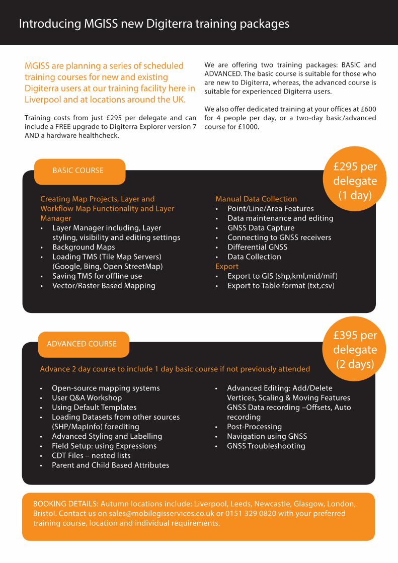
Introducing MGISS new Digiterra training packages
MGISS are planning a series of scheduled training courses for new and existing Digiterra users at our training facility here in Liverpool and at locations around the UK.
Training costs from just £295 per delegate and can include a FREE upgrade to Digiterra Explorer version 7 AND a hardware healthcheck.
We are offering two training packages: BASIC and ADVANCED. The basic course is suitable for those who are new to Digiterra, whereas, the advanced course is suitable for experienced Digiterra users.
We also offer dedicated training at your offices at £600 for 4 people per day, or a two-day basic/advanced course for £1000.
Creating Map Projects, Layer and Workflow Map Functionality and Layer Manager• Layer Manager including, Layer
styling, visibility and editing settings• Background Maps• Loading TMS (Tile Map Servers)
(Google, Bing, Open StreetMap)• Saving TMS for offline use• Vector/Raster Based Mapping
Manual Data Collection• Point/Line/Area Features• Data maintenance and editing• GNSS Data Capture• Connecting to GNSS receivers• Differential GNSS• Data Collection Export• Export to GIS (shp,kml,mid/mif )• Export to Table format (txt,csv)
• Open-source mapping systems• User Q&A Workshop• Using Default Templates• Loading Datasets from other sources
(SHP/MapInfo) forediting• Advanced Styling and Labelling• Field Setup: using Expressions• CDT Files – nested lists• Parent and Child Based Attributes
• Advanced Editing: Add/Delete Vertices, Scaling & Moving Features GNSS Data recording –Offsets, Auto recording
• Post-Processing• Navigation using GNSS• GNSS Troubleshooting
Advance 2 day course to include 1 day basic course if not previously attended
ADVANCED COURSE
BASIC COURSE £295 per delegate
(1 day)
£395 per delegate(2 days)
BOOKING DETAILS: Autumn locations include: Liverpool, Leeds, Newcastle, Glasgow, London, Bristol. Contact us on [email protected] or 0151 329 0820 with your preferred training course, location and individual requirements.

• What version of Digiterra do you currently use?• What is your main application area?• What functionality would you like to see included
in the software?• Do you foresee using cloud based services such as
maps and data transfer in the future?• How do you use smartphone apps for data
capture?
• Would you benefit from mobile GIS training?• Would you be prepared to pay for onsite/
classroom-based training?
MGISS are proud to work with the National Trust
The National Trust is carrying out an ongoing Plant Species survey so in April 2014, they started using 10 new Spectra Precision MobileMapper 120’s with the DigiTerra version 7 software installed supplied by Mobile GIS Services as part of our ongoing programme to replace some aging equipment. The National Trust has been using DigiTerra Explorer since 2007 to record the plants in its 200 plus gardens with great success.
Franklyn Tancock, Plant Collection Curator said: “The new units have greater accuracy and use GPS and GLONASS making it easier to capture high precision data. Early indications from staff and contractors indicate that they are very easy to use but with the added bonus of being much faster, producing more records each day. The digital camera function also means less equipment to carry around.
This work is all part of the National Trust’s aim to find out what plants are in each of their gardens, so that they can plan which plants need to be conserved or propagated using the specialist facilities of their new Plant Conservation Centre in Devon. This will ensure gardens are replenished as and when needed to continue their high horticultural standards”.
Digiterra Customers - Could we do better?We are continually working to improve and develop Digiterra and welcome your feedback to make the product even better.
Send feedback to:[email protected]
Digiterra and TreesDigiterra is now preloaded with workflows designed for the following types of tree survey:
• BS5837
• QTRA
• ESQCR
• ETR132 ‘Resilience’
• TPO
• Hazard Trees
• Subsidence