Embed Size (px)
Citation preview
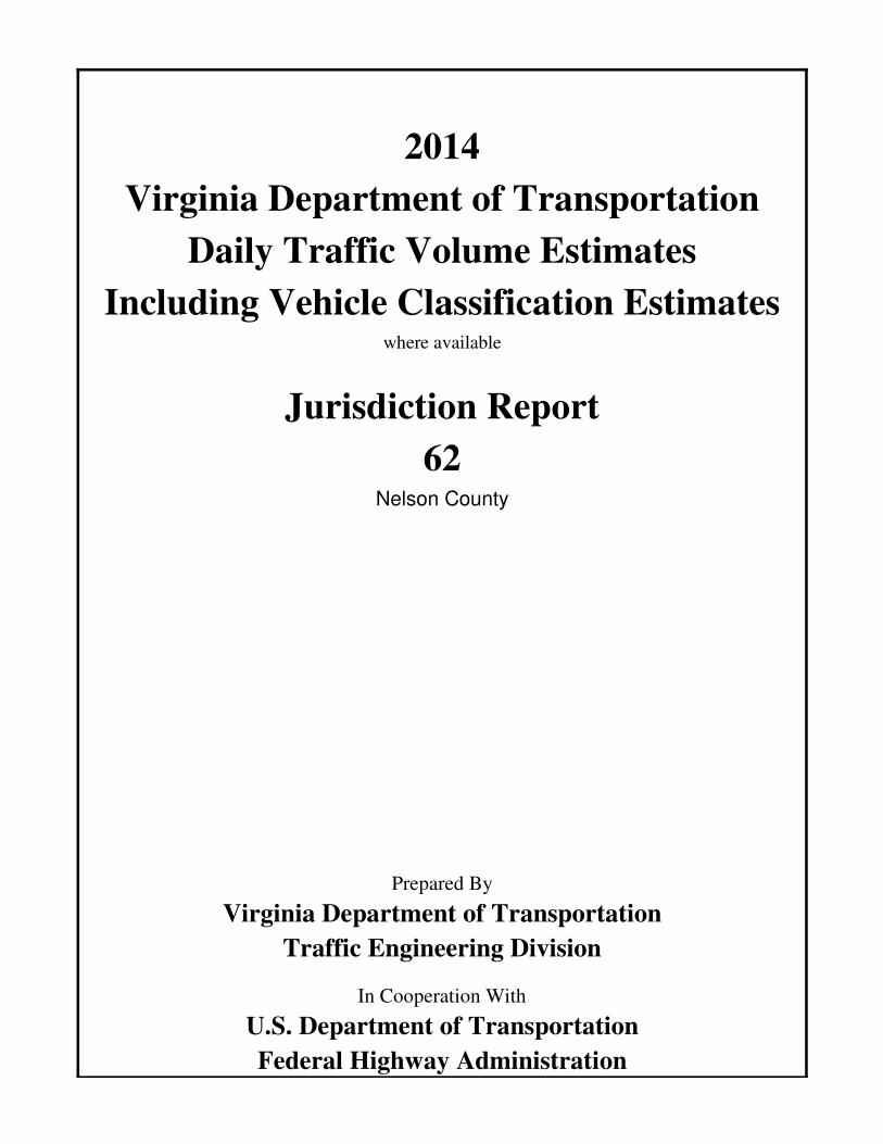
Virginia Department of Transportation
Jurisdiction Report
Daily Traffic Volume Estimates
Including Vehicle Classification Estimateswhere available
Nelson County
2014
Prepared By
Virginia Department of Transportation
Traffic Engineering Division
In Cooperation With
U.S. Department of Transportation
Federal Highway Administration
62
Virginia Department of Transportation
Traffic Engineering Division
Traffic Monitoring Section
The Virginia Department of Transportation (VDOT) conducts a program where traffic
count data are gathered from sensors in or along streets and highways and other sources.
From these data, estimates of the average number of vehicles that traveled each segment
of road are calculated. VDOT periodically publishes booklets listing these estimates.
One of these booklets, titled “Average Daily Traffic Volumes with Vehicle Classification
Data, on Interstate, Arterial and Primary Routes” includes a list of each Interstate and
Primary highway segment with the estimated Annual Average Daily Traffic (AADT) for
that segment. AADT is the total annual traffic estimate divided by the number of days in
the year. This booklet also includes information such as estimates of the percentage of
the AADT made up by 6 different vehicle types, ranging from cars to double trailer
trucks; estimated Annual Average Weekday Traffic (AAWDT), which is the number of
vehicles estimated to have traveled the segment of highway during a 24 hour weekday
averaged over the year; as well as Peak Hour and Peak Direction factors used by planners
to formulate design criteria.
In addition to the Primary and Interstate publication, one hundred books are published
periodically, one for each of 100 areas across the state defined by VDOT for record-
keeping purposes. These books include traffic volume estimates for roads within the
county, cities, and towns within the area. These books are titled “Daily Traffic Volumes
Including Vehicle Classification Estimates, where available; Jurisdiction Report numbers
00 through 99”.
Also available are a number of reports summarizing the average Vehicle Miles Traveled
(VMT) in selected jurisdictions and other categories of highways. There are many
different ways to present traffic volume summary information. Because the user
determines the value of each presentation, the reports have been redesigned based on user
requests and feedback. The people of the VDOT Traffic Engineering Division Traffic
Monitoring Section who produce these books welcome requests for other helpful ways of
presenting the summary information.
A compact disc (CD) is available that includes files in the Adobe® Portable Document
Format (PDF) that can be displayed, searched, and printed using common desktop
computer equipment. The CD includes the publications described above as well as a
number of other reports, including specialized VMT summaries and smaller AADT
reports for each city and town separately.
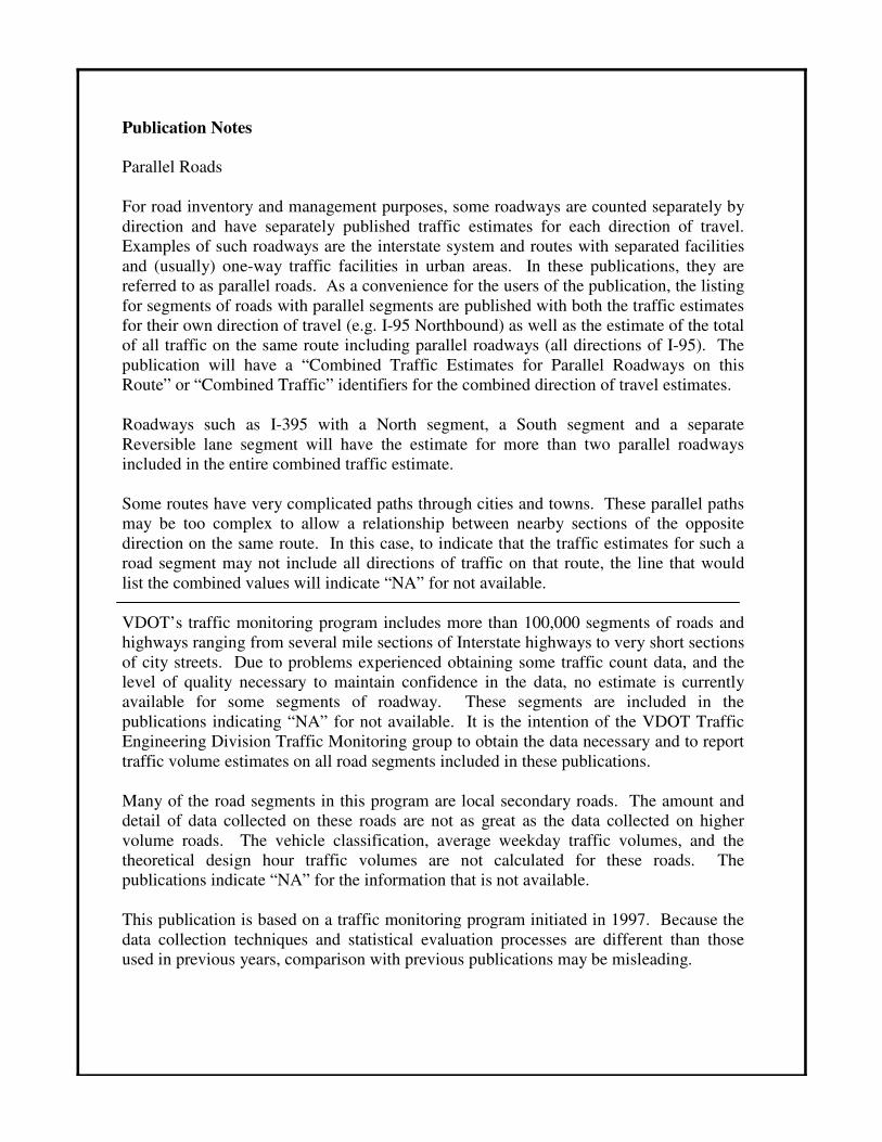
Publication Notes
Parallel Roads
For road inventory and management purposes, some roadways are counted separately by
direction and have separately published traffic estimates for each direction of travel.
Examples of such roadways are the interstate system and routes with separated facilities
and (usually) one-way traffic facilities in urban areas. In these publications, they are
referred to as parallel roads. As a convenience for the users of the publication, the listing
for segments of roads with parallel segments are published with both the traffic estimates
for their own direction of travel (e.g. I-95 Northbound) as well as the estimate of the total
of all traffic on the same route including parallel roadways (all directions of I-95). The
publication will have a “Combined Traffic Estimates for Parallel Roadways on this
Route” or “Combined Traffic” identifiers for the combined direction of travel estimates.
Roadways such as I-395 with a North segment, a South segment and a separate
Reversible lane segment will have the estimate for more than two parallel roadways
included in the entire combined traffic estimate.
Some routes have very complicated paths through cities and towns. These parallel paths
may be too complex to allow a relationship between nearby sections of the opposite
direction on the same route. In this case, to indicate that the traffic estimates for such a
road segment may not include all directions of traffic on that route, the line that would
list the combined values will indicate “NA” for not available.
VDOT’s traffic monitoring program includes more than 100,000 segments of roads and
highways ranging from several mile sections of Interstate highways to very short sections
of city streets. Due to problems experienced obtaining some traffic count data, and the
level of quality necessary to maintain confidence in the data, no estimate is currently
available for some segments of roadway. These segments are included in the
publications indicating “NA” for not available. It is the intention of the VDOT Traffic
Engineering Division Traffic Monitoring group to obtain the data necessary and to report
traffic volume estimates on all road segments included in these publications.
Many of the road segments in this program are local secondary roads. The amount and
detail of data collected on these roads are not as great as the data collected on higher
volume roads. The vehicle classification, average weekday traffic volumes, and the
theoretical design hour traffic volumes are not calculated for these roads. The
publications indicate “NA” for the information that is not available.
This publication is based on a traffic monitoring program initiated in 1997. Because the
data collection techniques and statistical evaluation processes are different than those
used in previous years, comparison with previous publications may be misleading.
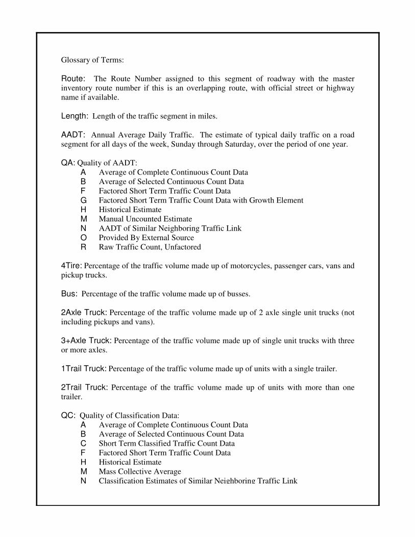
Glossary of Terms:
Route: The Route Number assigned to this segment of roadway with the master
inventory route number if this is an overlapping route, with official street or highway
name if available.
Length: Length of the traffic segment in miles.
AADT: Annual Average Daily Traffic. The estimate of typical daily traffic on a road
segment for all days of the week, Sunday through Saturday, over the period of one year.
QA: Quality of AADT:
A Average of Complete Continuous Count Data
B Average of Selected Continuous Count Data
F Factored Short Term Traffic Count Data
G Factored Short Term Traffic Count Data with Growth Element
H Historical Estimate
M Manual Uncounted Estimate
N AADT of Similar Neighboring Traffic Link
O Provided By External Source
R Raw Traffic Count, Unfactored
4Tire: Percentage of the traffic volume made up of motorcycles, passenger cars, vans and
pickup trucks.
Bus: Percentage of the traffic volume made up of busses.
2Axle Truck: Percentage of the traffic volume made up of 2 axle single unit trucks (not
including pickups and vans).
3+Axle Truck: Percentage of the traffic volume made up of single unit trucks with three
or more axles.
1Trail Truck: Percentage of the traffic volume made up of units with a single trailer.
2Trail Truck: Percentage of the traffic volume made up of units with more than one
trailer.
QC: Quality of Classification Data:
A Average of Complete Continuous Count Data
B Average of Selected Continuous Count Data
C Short Term Classified Traffic Count Data
F Factored Short Term Traffic Count Data
H Historical Estimate
M Mass Collective Average
N Classification Estimates of Similar Neighboring Traffic Link
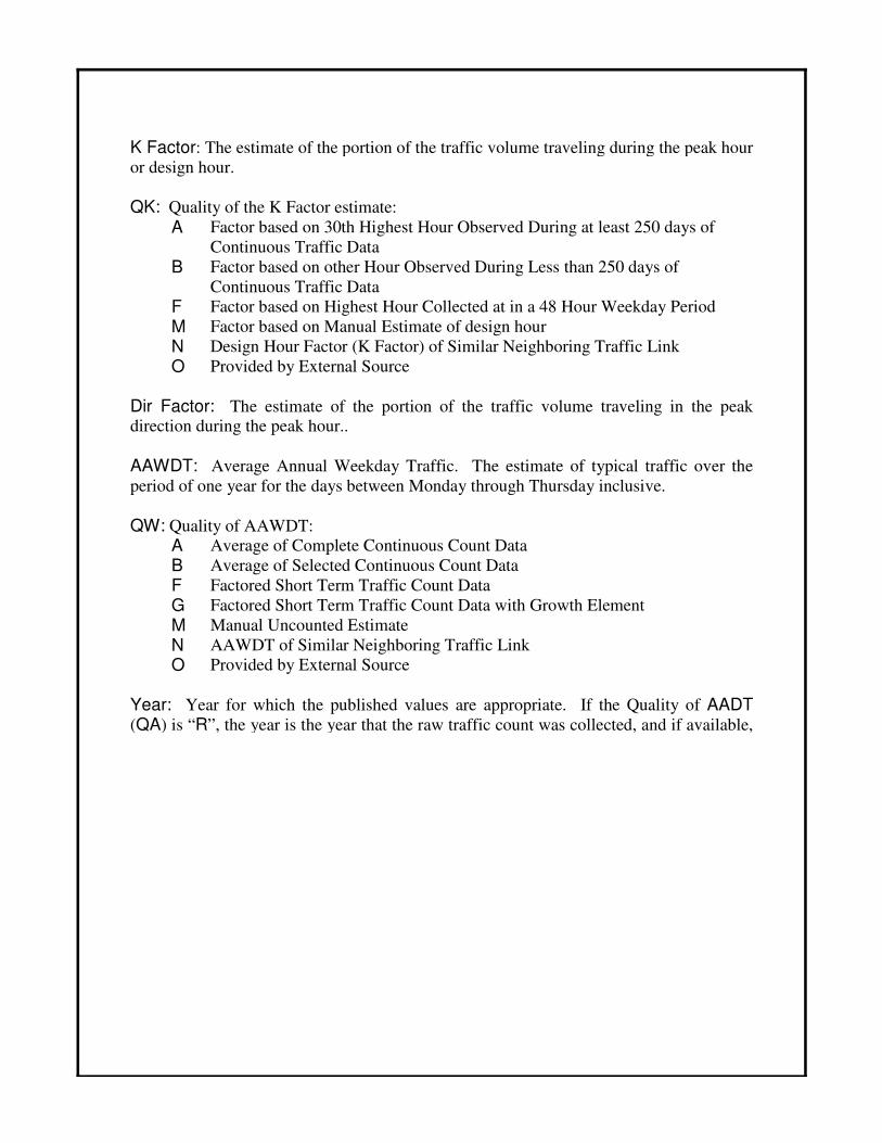
K Factor: The estimate of the portion of the traffic volume traveling during the peak hour
or design hour.
QK: Quality of the K Factor estimate:
A Factor based on 30th Highest Hour Observed During at least 250 days of
Continuous Traffic Data
B Factor based on other Hour Observed During Less than 250 days of
Continuous Traffic Data
F Factor based on Highest Hour Collected at in a 48 Hour Weekday Period
M Factor based on Manual Estimate of design hour
N Design Hour Factor (K Factor) of Similar Neighboring Traffic Link
O Provided by External Source
Dir Factor: The estimate of the portion of the traffic volume traveling in the peak direction during the peak hour..
AAWDT: Average Annual Weekday Traffic. The estimate of typical traffic over the
period of one year for the days between Monday through Thursday inclusive.
QW: Quality of AAWDT:
A Average of Complete Continuous Count Data
B Average of Selected Continuous Count Data
F Factored Short Term Traffic Count Data
G Factored Short Term Traffic Count Data with Growth Element
M Manual Uncounted Estimate
N AAWDT of Similar Neighboring Traffic Link
O Provided by External Source
Year: Year for which the published values are appropriate. If the Quality of AADT
(QA) is “R”, the year is the year that the raw traffic count was collected, and if available,
Bus
29
600
7
29
North
81
154600
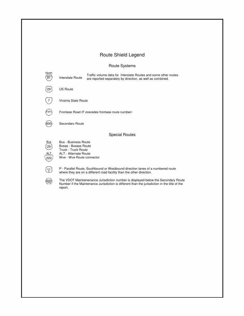
Interstate Route
US Route
Virginia State Route
ALT - Alternate Route
Bus - Business Route
Bypas - Bypass Route
Truck - Truck Route
Wye - Wye Route connector
Secondary Route
The VDOT Maintainenance Jurisdiction number is displayed below the Secondary Route Number if the Maintenance Jurisdiction is different than the jurisdiction in the title of the report.
P - Parallel Route; Southbound or Westbound direction lanes of a numbered route where they are on a different road facility than the other direction.
ALT
220
11P
Traffic volume data for Interstate Routes and some other routes are reported separately by direction, as well as combined.
Route Shield Legend
Route Systems
Special Routes
Frontage Road (F precedes frontage route number)F241
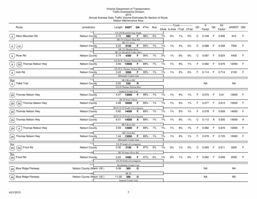
Virginia Department of TransportationTraffic Engineering Division
2014Annual Average Daily Traffic Volume Estimates By Section of Route
Nelson Maintenance Area
Route Jurisdiction AADT1Trail 2Trail
4TireK
QA2Axle 3+Axle
QC QKBusLength---------------Truck---------------
FactorAAWDT QW
Dir
Factor
Afton Mountain Rd 890 0% 1% 0.109 910F F0% 1% C F
US 250 Rockfish Gap Trnpk
SR 151 Critzers Shop Rd
98%
From:
To:
From:
Nelson County 3.72 0%6
SR 151 Avon
0.555
8100 1% 1% 0.088 7500F F1% 4% C F
SR 151 Martins Store
93%
From:
To:
Nelson County151 6.22 0%6
SR 151 Rockfish Valley Hwy
0.558
River Rd 4300 1% 2% 0.097 4400F F1% 6% C F
US 29 W, Thomas Nelson Hwy
90%
From:To:
Nelson County 5.79 0%6 0.624
Thomas Nelson Hwy 12000 1% 1% 0.082 12000F F1% 9% F F
US 29 E, Thomas Nelson Hwy
89%
From:To:
Nelson County29 3.94 1%6 0.676
Irish Rd 2000 1% 1% 0.114 2100F F1% 2% F F
Albemarle County Line
95%To:
Nelson County 3.43 0%6 0.714
Tidbit Trail 530 NA NAR
SR 6 River Rd
US 29 Thomas Nelson HwyTo:
From:
Nelson County 0.20
Wye
6
Thomas Nelson Hwy 13000 1% 1% 0.075 13000F F1% 9% F F
Amherst County Line
SR 56 Near Colleen
89%
From:
To:
From:
Nelson County 4.47 1%29 0.61
Thomas Nelson Hwy 16000 1% 1% 0.077 15000F F1% 9% F F
BUS US 29 South of Lovingston
89%
From:
To:
Nelson County56 4.28 1%29 0.613
Thomas Nelson Hwy 14000 1% 1% 0.078 14000F F1% 9% F F
BUS US 29 North of Lovingston
89%
From:
To:
Nelson County 0.82 1%29 0.628
Thomas Nelson Hwy 14000 1% 1% 0.112 14000A A1% 9% C A
SR 6 River Rd
89%
From:To:
Nelson County 6.51 1%29 0.505
Thomas Nelson Hwy 12000 1% 1% 0.082 12000F F1% 9% F F
SR 6 Irish Rd
89%
From:To:
Nelson County6 3.94 1%29 0.676
Thomas Nelson Hwy 13000 1% 1% 0.078 13000F F1% 9% F F
Albemarle County Line
89%To:
Nelson County 1.44 1%29 0.725
Front Rd 3100 0% 1% 0.093 3200F F0% 1% C F
US 29 South of Lovingston
SR 56 James River Rd
97%
Bus From:To:
From:
Nelson County56 0.30 0%
Bus
29 0.611
Front Rd 2400 0% 1% 0.092 2500F F0% 1% F F
US 29 North of Lovingston
97%To:
Nelson County 0.63 0%29 0.659
Blue Ridge Parkway 300 NA NAO
Rockbridge County Line
SR 56From:
To:
From:
Nelson County (Maint: US ) 0.0848
Blue Ridge Parkway 390 NA NAO
Augusta County LineTo:
Nelson County (Maint: US ) 11.0948
74/21/2015
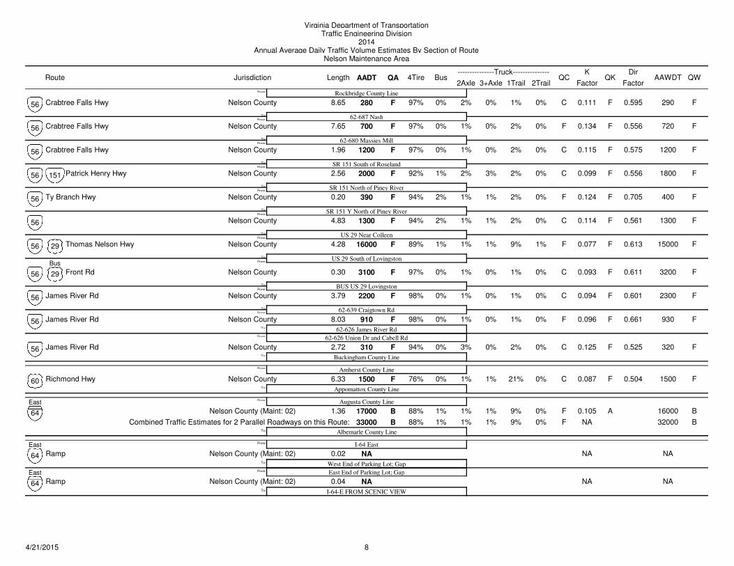
Virginia Department of TransportationTraffic Engineering Division
2014Annual Average Daily Traffic Volume Estimates By Section of Route
Nelson Maintenance Area
Route Jurisdiction AADT1Trail 2Trail
4TireK
QA2Axle 3+Axle
QC QKBusLength---------------Truck---------------
FactorAAWDT QW
Dir
Factor
Crabtree Falls Hwy 280 0% 2% 0.111 290F F0% 1% C F
Rockbridge County Line
62-687 Nash
97%
From:To:
From:
Nelson County 8.65 0%56 0.595
Crabtree Falls Hwy 700 0% 1% 0.134 720F F0% 2% F F
62-680 Massies Mill
97%
From:To:
Nelson County 7.65 0%56 0.556
Crabtree Falls Hwy 1200 0% 1% 0.115 1200F F0% 2% C F
SR 151 South of Roseland
97%
From:To:
Nelson County 1.96 0%56 0.575
Patrick Henry Hwy 2000 1% 2% 0.099 1800F F3% 2% C F
SR 151 North of Piney River
92%
From:To:
Nelson County151 2.56 0%56 0.556
Ty Branch Hwy 390 2% 1% 0.124 400F F1% 2% F F
SR 151 Y North of Piney River
94%
From:
To:
Nelson County 0.20 0%56 0.705
1300 2% 1% 0.114 1300F F1% 2% C F
US 29 Near Colleen
94%
From:
To:
Nelson County 4.83 0%56 0.561
Thomas Nelson Hwy 16000 1% 1% 0.077 15000F F1% 9% F F
US 29 South of Lovingston
89%
Bus From:
To:
Nelson County29 4.28 1%56 0.613
Front Rd 3100 0% 1% 0.093 3200F F0% 1% C F
BUS US 29 Lovingston
97%
From:
To:
Nelson County29 0.30 0%56 0.611
James River Rd 2200 0% 1% 0.094 2300F F0% 1% C F
62-639 Craigtown Rd
98%
From:
To:
Nelson County 3.79 0%56 0.601
James River Rd 910 0% 1% 0.096 930F F0% 1% F F
62-626 James River Rd
98%
From:
To:
Nelson County 8.03 0%56
62-626 Union Dr and Cabell Rd
0.661
James River Rd 310 0% 3% 0.125 320F F0% 2% C F
Buckingham County Line
94%To:
Nelson County 2.72 0%56 0.525
Richmond Hwy 1500 0% 1% 0.087 1500F F1% 21% C F
Amherst County Line
Appomattox County Line
76%To:
From:
Nelson County 6.33 0%60 0.504
17000 1% 1% 0.105 16000B A1% 9% F B
Augusta County Line
Albemarle County Line
88%
To:
From:
Nelson County (Maint: 02) 1.36 0%
East
64
33000 1% 1% NA 32000B 1% 9% F B88% 0%Combined Traffic Estimates for 2 Parallel Roadways on this Route:
Ramp NA NA NA
I-64 East
West End of Parking Lot; Gap
East From:
To:
From:
Nelson County (Maint: 02) 0.02
East
64
East End of Parking Lot; Gap
Ramp NA NA NA
I-64-E FROM SCENIC VIEWTo:
Nelson County (Maint: 02) 0.0464
84/21/2015
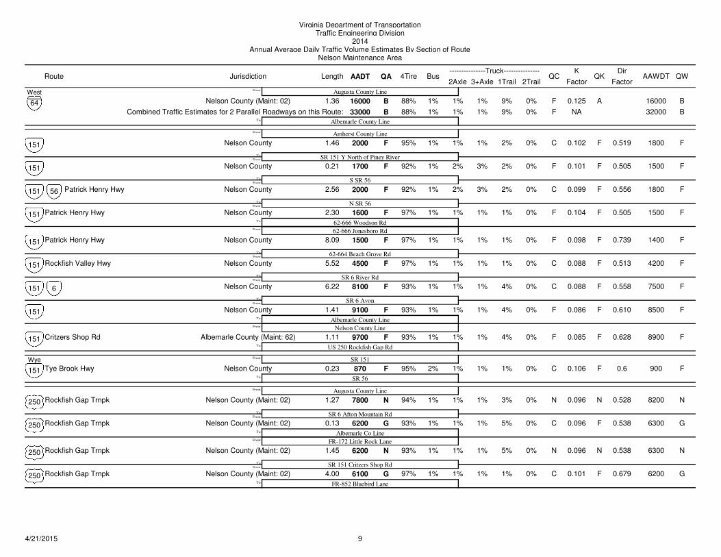
Virginia Department of TransportationTraffic Engineering Division
2014Annual Average Daily Traffic Volume Estimates By Section of Route
Nelson Maintenance Area
Route Jurisdiction AADT1Trail 2Trail
4TireK
QA2Axle 3+Axle
QC QKBusLength---------------Truck---------------
FactorAAWDT QW
Dir
Factor
16000 1% 1% 0.125 16000B A1% 9% F B
Augusta County Line
Albemarle County Line
88%
To:
From:
Nelson County (Maint: 02) 1.36 0%
West
64
33000 1% 1% NA 32000B 1% 9% F B88% 0%Combined Traffic Estimates for 2 Parallel Roadways on this Route:
2000 1% 1% 0.102 1800F F1% 2% C F
Amherst County Line
SR 151 Y North of Piney River
95%
From:To:
From:
Nelson County 1.46 0%151 0.519
1700 1% 2% 0.101 1500F F3% 2% F F
S SR 56
92%
From:To:
Nelson County 0.21 0%151 0.505
Patrick Henry Hwy 2000 1% 2% 0.099 1800F F3% 2% C F
N SR 56
92%
From:To:
Nelson County56 2.56 0%151 0.556
Patrick Henry Hwy 1600 1% 1% 0.104 1500F F1% 1% F F
62-666 Woodson Rd
97%
From:
To:
Nelson County 2.30 0%151
62-666 Jonesboro Rd
0.505
Patrick Henry Hwy 1500 1% 1% 0.098 1400F F1% 1% F F
62-664 Beach Grove Rd
97%
From:
To:
Nelson County 8.09 0%151 0.739
Rockfish Valley Hwy 4500 1% 1% 0.088 4200F F1% 1% C F
SR 6 River Rd
97%
From:
To:
Nelson County 5.52 0%151 0.513
8100 1% 1% 0.088 7500F F1% 4% C F
SR 6 Avon
93%
From:
To:
Nelson County6 6.22 0%151 0.558
9100 1% 1% 0.086 8500F F1% 4% F F
Albemarle County Line
93%
From:
To:
Nelson County 1.41 0%151
Nelson County Line
0.610
Critzers Shop Rd 9700 1% 1% 0.085 8900F F1% 4% F F
US 250 Rockfish Gap Rd
93%To:
Albemarle County (Maint: 62) 1.11 0%151 0.628
Tye Brook Hwy 870 2% 1% 0.106 900F F1% 1% C F
SR 151
SR 56
95%To:
From:
Nelson County 0.23 0%
Wye
151 0.6
Rockfish Gap Trnpk 7800 1% 1% 0.096 8200N N1% 3% N N
Augusta County Line
SR 6 Afton Mountain Rd
94%
From:To:
From:
Nelson County (Maint: 02) 1.27 0%250 0.528
Rockfish Gap Trnpk 6200 1% 1% 0.096 6300G F1% 5% C G
Albemarle Co Line
93%
From:
To:
Nelson County (Maint: 02) 0.13 0%250
FR-172 Little Rock Lane
0.538
Rockfish Gap Trnpk 6200 1% 1% 0.096 6300N N1% 5% N N
SR 151 Critzers Shop Rd
93%
From:
To:
Nelson County (Maint: 02) 1.45 0%250 0.538
Rockfish Gap Trnpk 6100 1% 1% 0.101 6200G F1% 1% C G
FR-852 Bluebird Lane
97%To:
Nelson County (Maint: 02) 4.00 0%250 0.679
94/21/2015
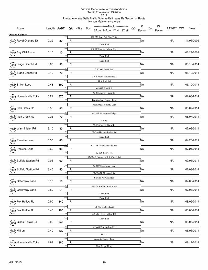
Virginia Department of TransportationTraffic Engineering Division
2014Annual Average Daily Traffic Volume Estimates By Section of Route
Nelson Maintenance Area
Route AADT1Trail 2Trail
4TireK
QA2Axle 3+Axle
QC QKBusLength---------------Truck---------------
FactorAAWDT QW Year
Dir
Factor
Royal Orchard Dr 20 NA NAR
US 250 Rockfish Gap Tpke
Dead EndTo:
From:
0.29
Nelson County
11/06/2006F182
Sky Cliff Place 10 NA NAR
US 29 Thomas Nelson Hwy
Dead EndTo:
From:
0.10 06/23/2008F630
Stage Coach Rd 50 NA NAR
Dead End
0.60 ME Dead EndFrom:
To:
From:
0.60 08/19/2014600
Stage Coach Rd 70 NA NAR
SR 6 Afton Mountain RdTo:
0.10 08/19/2014600
Shiloh Loop 100 NA NAR
SR 6 Irish Rd
62-632 Pond RdTo:
From:
0.48 05/10/2011601
Howardsville Tpke 370 NA NAR
62-626 James River Rd
Buckingham County LineTo:
From:
0.21 07/08/2014602
Irish Creek Rd 50 NA NAR
Rockbridge County Line
62-813 Whetstone RidgeFrom:
To:
From:
0.55 08/07/2014603
Irish Creek Rd 70 NA NAR
SR 56To:
0.23 08/07/2014603
Warminister Rd 30 NA NAR
62-626 James River Rd
62-646 Hunting Lodge RdTo:
From:
3.10 07/08/2014604
Peavine Lane 80 NA NAR
Dead End
62-848 Whippoorwill LaneFrom:
To:
From:
0.50 04/28/2011605
Peavine Lane 90 NA NAR
62-639 Laurel RdTo:
0.60 07/24/2014605
Buffalo Station Rd 60 NA NAR
62-626 S, Norwood Rd, Cabell Rd
62-607 Greenway LaneFrom:
To:
From:
0.05 07/08/2014606
Buffalo Station Rd 50 NA NAR
62-626 N, Norwood RdTo:
3.45 07/08/2014606
Greenway Lane 10 NA NAR
62-626 Norwood Rd
62-606 Buffalo Station RdFrom:
To:
From:
0.10 07/08/2014607
Greenway Lane 7 NA NAR
Dead EndTo:
0.80 07/08/2014607
Fox Hollow Rd 140 NA NAR
Dead End
62-783 Hatties LaneFrom:
To:
From:
0.90 08/05/2014608
Fox Hollow Rd 190 NA NAR
62-609 Glass Hollow RdTo:
0.40 08/05/2014608
Glass Hollow Rd 240 NA NAR
Dead End
62-608 Fox Hollow RdFrom:
To:
From:
2.00 08/05/2014609
Mill Ln 420 NA NAR
SR 151To:
0.40 08/05/2014609
Howardsville Tpke 380 NA NAR
Augusta County Line
Blue Ridge PkwyTo:
From:
1.98 08/19/2014610
104/21/2015
Virginia Department of TransportationTraffic Engineering Division
2014Annual Average Daily Traffic Volume Estimates By Section of Route
Nelson Maintenance Area
Route AADT1Trail 2Trail
4TireK
QA2Axle 3+Axle
QC QKBusLength---------------Truck---------------
FactorAAWDT QW Year
Dir
Factor
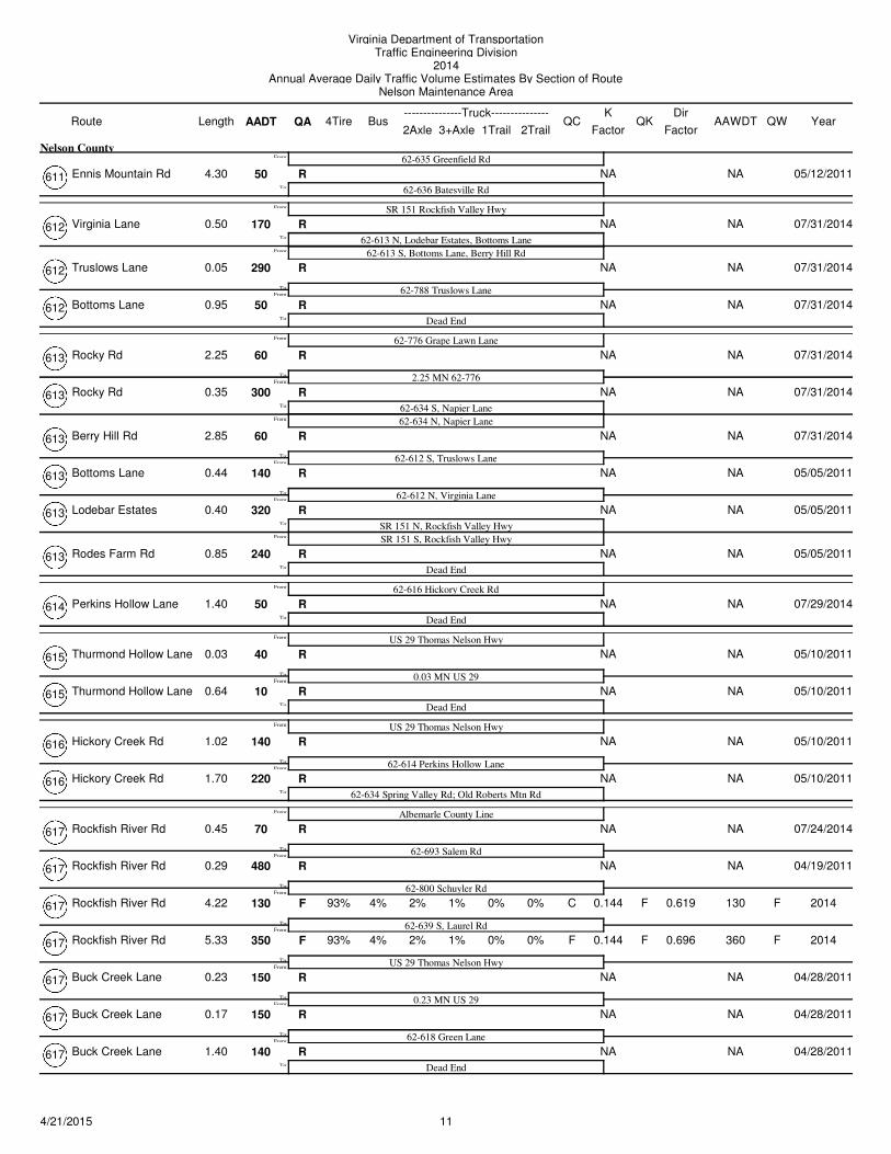
Ennis Mountain Rd 50 NA NAR
62-635 Greenfield Rd
62-636 Batesville RdTo:
From:
4.30
Nelson County
05/12/2011611
Virginia Lane 170 NA NAR
SR 151 Rockfish Valley Hwy
62-613 N, Lodebar Estates, Bottoms LaneFrom:
To:
From:
0.50 07/31/2014612
62-613 S, Bottoms Lane, Berry Hill Rd
Truslows Lane 290 NA NAR
62-788 Truslows LaneFrom:
To:
0.05 07/31/2014612
Bottoms Lane 50 NA NAR
Dead EndTo:
0.95 07/31/2014612
Rocky Rd 60 NA NAR
62-776 Grape Lawn Lane
2.25 MN 62-776From:
To:
From:
2.25 07/31/2014613
Rocky Rd 300 NA NAR
62-634 S, Napier LaneFrom:
To:
0.35 07/31/2014613
62-634 N, Napier Lane
Berry Hill Rd 60 NA NAR
62-612 S, Truslows LaneFrom:
To:
2.85 07/31/2014613
Bottoms Lane 140 NA NAR
62-612 N, Virginia LaneFrom:
To:
0.44 05/05/2011613
Lodebar Estates 320 NA NAR
SR 151 N, Rockfish Valley HwyFrom:
To:
0.40 05/05/2011613
SR 151 S, Rockfish Valley Hwy
Rodes Farm Rd 240 NA NAR
Dead EndTo:
0.85 05/05/2011613
Perkins Hollow Lane 50 NA NAR
62-616 Hickory Creek Rd
Dead EndTo:
From:
1.40 07/29/2014614
Thurmond Hollow Lane 40 NA NAR
US 29 Thomas Nelson Hwy
0.03 MN US 29From:
To:
From:
0.03 05/10/2011615
Thurmond Hollow Lane 10 NA NAR
Dead EndTo:
0.64 05/10/2011615
Hickory Creek Rd 140 NA NAR
US 29 Thomas Nelson Hwy
62-614 Perkins Hollow LaneFrom:
To:
From:
1.02 05/10/2011616
Hickory Creek Rd 220 NA NAR
62-634 Spring Valley Rd; Old Roberts Mtn RdTo:
1.70 05/10/2011616
Rockfish River Rd 70 NA NAR
Albemarle County Line
62-693 Salem RdFrom:
To:
From:
0.45 07/24/2014617
Rockfish River Rd 480 NA NAR
62-800 Schuyler RdFrom:
To:
0.29 04/19/2011617
Rockfish River Rd 130 4% 2% 0.144 130F F1% 0% C F
62-639 S, Laurel Rd
93%
From:To:
4.22 0% 2014617 0.619
Rockfish River Rd 350 4% 2% 0.144 360F F1% 0% F F
US 29 Thomas Nelson Hwy
93%
From:
To:
5.33 0% 2014617 0.696
Buck Creek Lane 150 NA NAR
0.23 MN US 29From:
To:
0.23 04/28/2011617
Buck Creek Lane 150 NA NAR
62-618 Green LaneFrom:
To:
0.17 04/28/2011617
Buck Creek Lane 140 NA NAR
Dead EndTo:
1.40 04/28/2011617
114/21/2015
Virginia Department of TransportationTraffic Engineering Division
2014Annual Average Daily Traffic Volume Estimates By Section of Route
Nelson Maintenance Area
Route AADT1Trail 2Trail
4TireK
QA2Axle 3+Axle
QC QKBusLength---------------Truck---------------
FactorAAWDT QW Year
Dir
Factor
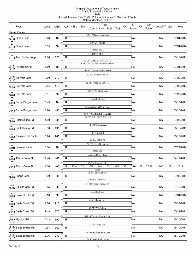
Green Lane 40 NA NAR
62-617 Buck Creek Lane
0.20 MN 62-617From:
To:
From:
0.20
Nelson County
07/31/2014618
Green Lane 30 NA NAR
Dead EndTo:
0.35 07/31/2014618
Twin Poplar Loop 320 NA NAR
US 29; SR 6
62-634 S, Old Roberts Mtn RdFrom:
To:
From:
1.10 05/12/2011619
62-634 N, Old Roberts Mountain Rd
Hill Hollow Rd 40 NA NAR
62-810 Duncan Hollow LoopTo:
1.80 07/31/2014619
Starvale Lane 210 NA NAR
62-623 Stage Bridge Rd
62-640 Wheelers Cove RdFrom:
To:
From:
0.60 07/29/2014620
Starvale Lane 110 NA NAR
62-831 Woodson LaneFrom:
To:
0.54 07/29/2014620
Starvale Lane 30 NA NAR
Dead End; GapFrom:
To:
0.31 07/29/2014620
Farrar Bridge Lane 70 NA NAR
62-689 Oakland Farm LaneFrom:
To:
0.45 05/10/2011620
Farrar Bridge Lane 150 NA NAR
62-617 W, Rockfish River RdFrom:
To:
0.20 05/10/2011620
62-617 E, Rockfish River Rd
Rock Spring Rd 80 NA NAR
62-670 Church LaneFrom:
To:
1.80 07/29/2014620
Rock Spring Rd 190 NA NAR
SR 6 Irish RdFrom:
To:
0.30 05/10/2011620
Pleasant Hill Circle 240 NA NAR
62-632 Faber RdTo:
0.20 05/10/2011620
Spencer Lane 20 NA NAR
62-623 Stage Bridge Rd
Dead EndTo:
From:
0.14 07/29/2014621
Allens Creek Rd 180 NA NAR
Amherst County Line
62-656 Gladstone RdFrom:
To:
From:
1.40 04/19/2011622
Allens Creek Rd 100 5% 0% 0.16 100F F0% 0% C F
US 60
95%
From:
To:
1.00 0% 2014622
US 60 Richmond Hwy
0.533
Spring Lane 60 NA NAR
62-626 Cabell RdTo:
0.60 07/08/2014622
Shields Gap Rd 60 NA NAR
SR 151 Patrick Henry Hwy
Dead End; GapFrom:
To:
From:
0.55 07/17/2014623
Davis Creek Rd 60 NA NAR
62-625 Perry LaneFrom:
To:
2.10 07/31/2014623
Davis Creek Rd 210 NA NAR
62-756 Wright LaneFrom:
To:
1.00 05/12/2011623
Davis Creek Rd 370 NA NAR
US 29 Thomas Nelson HwyFrom:
To:
2.13 05/12/2011623
Myndus Rd 390 NA NAR
62-624 Pine TrailFrom:
To:
0.43 05/10/2011623
Stage Bridge Rd 350 NA NAR
62-700 Walnut Grove LaneFrom:
To:
0.64 05/10/2011623
Stage Bridge Rd 270 NA NAR
62-617 Rockfish River RdTo:
3.76 05/10/2011623
124/21/2015
Virginia Department of TransportationTraffic Engineering Division
2014Annual Average Daily Traffic Volume Estimates By Section of Route
Nelson Maintenance Area
Route AADT1Trail 2Trail
4TireK
QA2Axle 3+Axle
QC QKBusLength---------------Truck---------------
FactorAAWDT QW Year
Dir
Factor
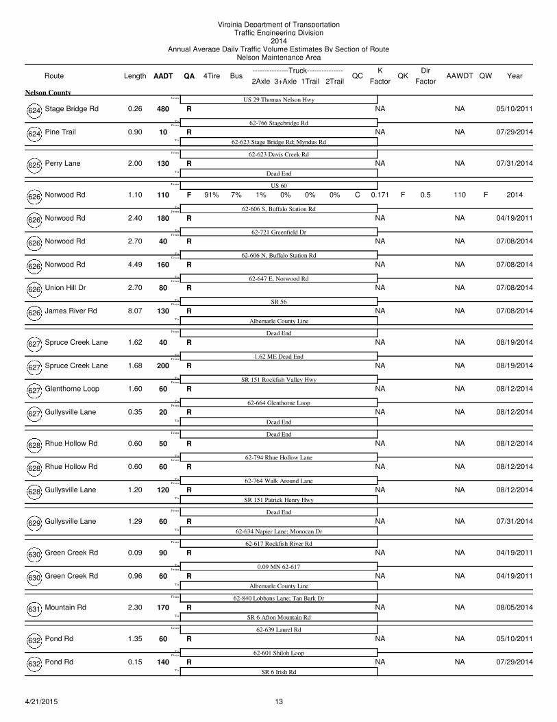
Stage Bridge Rd 480 NA NAR
US 29 Thomas Nelson Hwy
62-766 Stagebridge RdFrom:
To:
From:
0.26
Nelson County
05/10/2011624
Pine Trail 10 NA NAR
62-623 Stage Bridge Rd; Myndus RdTo:
0.90 07/29/2014624
Perry Lane 130 NA NAR
62-623 Davis Creek Rd
Dead EndTo:
From:
2.00 07/31/2014625
Norwood Rd 110 7% 1% 0.171 110F F0% 0% C F
US 60
62-606 S, Buffalo Station Rd
91%
From:
To:
From:
1.10 0% 2014626 0.5
Norwood Rd 180 NA NAR
62-721 Greenfield DrFrom:
To:
2.40 04/19/2011626
Norwood Rd 40 NA NAR
62-606 N, Buffalo Station RdFrom:
To:
2.70 07/08/2014626
Norwood Rd 160 NA NAR
62-647 E, Norwood RdFrom:
To:
4.49 07/08/2014626
Union Hill Dr 80 NA NAR
SR 56From:
To:
2.70 07/08/2014626
James River Rd 130 NA NAR
Albemarle County LineTo:
8.07 07/08/2014626
Spruce Creek Lane 40 NA NAR
Dead End
1.62 ME Dead EndFrom:
To:
From:
1.62 08/19/2014627
Spruce Creek Lane 200 NA NAR
SR 151 Rockfish Valley HwyFrom:
To:
1.68 08/19/2014627
Glenthorne Loop 60 NA NAR
62-664 Glenthorne LoopFrom:
To:
1.60 08/12/2014627
Gullysville Lane 20 NA NAR
Dead EndTo:
0.35 08/12/2014627
Rhue Hollow Rd 50 NA NAR
Dead End
62-794 Rhue Hollow LaneFrom:
To:
From:
0.60 08/12/2014628
Rhue Hollow Rd 60 NA NAR
62-764 Walk Around LaneFrom:
To:
0.60 08/12/2014628
Gullysville Lane 120 NA NAR
SR 151 Patrick Henry HwyTo:
1.20 08/12/2014628
Gullysville Lane 60 NA NAR
Dead End
62-634 Napier Lane; Monocan DrTo:
From:
1.29 07/31/2014629
Green Creek Rd 90 NA NAR
62-617 Rockfish River Rd
0.09 MN 62-617From:
To:
From:
0.09 04/19/2011630
Green Creek Rd 60 NA NAR
Albemarle County LineTo:
0.96 04/19/2011630
Mountain Rd 170 NA NAR
62-840 Lobbans Lane; Tan Bark Dr
SR 6 Afton Mountain RdTo:
From:
2.30 08/05/2014631
Pond Rd 60 NA NAR
62-639 Laurel Rd
62-601 Shiloh LoopFrom:
To:
From:
1.35 05/10/2011632
Pond Rd 140 NA NAR
SR 6 Irish RdTo:
0.15 07/29/2014632
134/21/2015
Virginia Department of TransportationTraffic Engineering Division
2014Annual Average Daily Traffic Volume Estimates By Section of Route
Nelson Maintenance Area
Route AADT1Trail 2Trail
4TireK
QA2Axle 3+Axle
QC QKBusLength---------------Truck---------------
FactorAAWDT QW Year
Dir
Factor
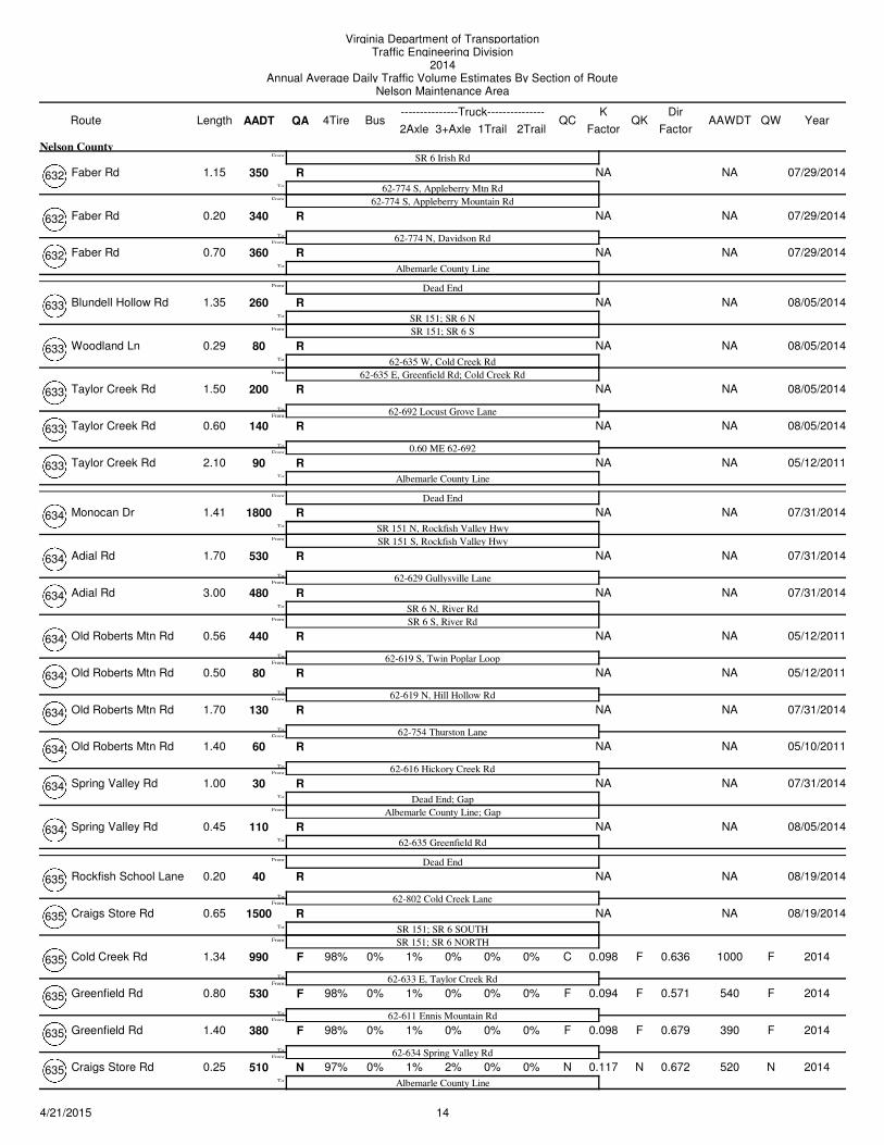
Faber Rd 350 NA NAR
SR 6 Irish Rd
62-774 S, Appleberry Mtn RdFrom:
To:
From:
1.15
Nelson County
07/29/2014632
62-774 S, Appleberry Mountain Rd
Faber Rd 340 NA NAR
62-774 N, Davidson RdFrom:
To:
0.20 07/29/2014632
Faber Rd 360 NA NAR
Albemarle County LineTo:
0.70 07/29/2014632
Blundell Hollow Rd 260 NA NAR
Dead End
SR 151; SR 6 NFrom:
To:
From:
1.35 08/05/2014633
SR 151; SR 6 S
Woodland Ln 80 NA NAR
62-635 W, Cold Creek RdFrom:
To:
0.29 08/05/2014633
62-635 E, Greenfield Rd; Cold Creek Rd
Taylor Creek Rd 200 NA NAR
62-692 Locust Grove LaneFrom:
To:
1.50 08/05/2014633
Taylor Creek Rd 140 NA NAR
0.60 ME 62-692From:
To:
0.60 08/05/2014633
Taylor Creek Rd 90 NA NAR
Albemarle County LineTo:
2.10 05/12/2011633
Monocan Dr 1800 NA NAR
Dead End
SR 151 N, Rockfish Valley HwyFrom:
To:
From:
1.41 07/31/2014634
SR 151 S, Rockfish Valley Hwy
Adial Rd 530 NA NAR
62-629 Gullysville LaneFrom:
To:
1.70 07/31/2014634
Adial Rd 480 NA NAR
SR 6 N, River RdFrom:
To:
3.00 07/31/2014634
SR 6 S, River Rd
Old Roberts Mtn Rd 440 NA NAR
62-619 S, Twin Poplar LoopFrom:
To:
0.56 05/12/2011634
Old Roberts Mtn Rd 80 NA NAR
62-619 N, Hill Hollow RdFrom:
To:
0.50 05/12/2011634
Old Roberts Mtn Rd 130 NA NAR
62-754 Thurston LaneFrom:
To:
1.70 07/31/2014634
Old Roberts Mtn Rd 60 NA NAR
62-616 Hickory Creek RdFrom:
To:
1.40 05/10/2011634
Spring Valley Rd 30 NA NAR
Dead End; GapFrom:
To:
1.00 07/31/2014634
Albemarle County Line; Gap
Spring Valley Rd 110 NA NAR
62-635 Greenfield RdTo:
0.45 08/05/2014634
Rockfish School Lane 40 NA NAR
Dead End
62-802 Cold Creek LaneFrom:
To:
From:
0.20 08/19/2014635
Craigs Store Rd 1500 NA NAR
SR 151; SR 6 SOUTHFrom:
To:
0.65 08/19/2014635
SR 151; SR 6 NORTH
Cold Creek Rd 990 0% 1% 0.098 1000F F0% 0% C F
62-633 E, Taylor Creek Rd
98%
From:
To:
1.34 0% 2014635 0.636
Greenfield Rd 530 0% 1% 0.094 540F F0% 0% F F
62-611 Ennis Mountain Rd
98%
From:To:
0.80 0% 2014635 0.571
Greenfield Rd 380 0% 1% 0.098 390F F0% 0% F F
62-634 Spring Valley Rd
98%
From:
To:
1.40 0% 2014635 0.679
Craigs Store Rd 510 0% 1% 0.117 520N N2% 0% N N
Albemarle County Line
97%To:
0.25 0% 2014635 0.672
144/21/2015
Virginia Department of TransportationTraffic Engineering Division
2014Annual Average Daily Traffic Volume Estimates By Section of Route
Nelson Maintenance Area
Route AADT1Trail 2Trail
4TireK
QA2Axle 3+Axle
QC QKBusLength---------------Truck---------------
FactorAAWDT QW Year
Dir
Factor
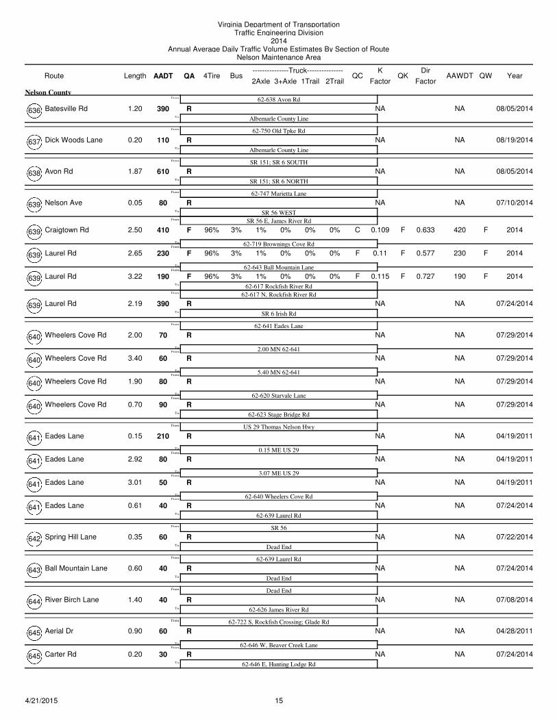
Batesville Rd 390 NA NAR
62-638 Avon Rd
Albemarle County LineTo:
From:
1.20
Nelson County
08/05/2014636
Dick Woods Lane 110 NA NAR
62-750 Old Tpke Rd
Albemarle County LineTo:
From:
0.20 08/19/2014637
Avon Rd 610 NA NAR
SR 151; SR 6 SOUTH
SR 151; SR 6 NORTHTo:
From:
1.87 08/05/2014638
Nelson Ave 80 NA NAR
62-747 Marietta Lane
SR 56 WESTFrom:
To:
From:
0.05 07/10/2014639
SR 56 E, James River Rd
Craigtown Rd 410 3% 1% 0.109 420F F0% 0% C F
62-719 Brownings Cove Rd
96%
From:To:
2.50 0% 2014639 0.633
Laurel Rd 230 3% 1% 0.11 230F F0% 0% F F
62-643 Ball Mountain Lane
96%
From:To:
2.65 0% 2014639 0.577
Laurel Rd 190 3% 1% 0.115 190F F0% 0% F F
62-617 Rockfish River Rd
96%
From:
To:
3.22 0% 2014639
62-617 N, Rockfish River Rd
0.727
Laurel Rd 390 NA NAR
SR 6 Irish RdTo:
2.19 07/24/2014639
Wheelers Cove Rd 70 NA NAR
62-641 Eades Lane
2.00 MN 62-641From:
To:
From:
2.00 07/29/2014640
Wheelers Cove Rd 60 NA NAR
5.40 MN 62-641From:
To:
3.40 07/29/2014640
Wheelers Cove Rd 80 NA NAR
62-620 Starvale LaneFrom:
To:
1.90 07/29/2014640
Wheelers Cove Rd 90 NA NAR
62-623 Stage Bridge RdTo:
0.70 07/29/2014640
Eades Lane 210 NA NAR
US 29 Thomas Nelson Hwy
0.15 ME US 29From:
To:
From:
0.15 04/19/2011641
Eades Lane 80 NA NAR
3.07 ME US 29From:
To:
2.92 04/19/2011641
Eades Lane 50 NA NAR
62-640 Wheelers Cove RdFrom:
To:
3.01 04/19/2011641
Eades Lane 40 NA NAR
62-639 Laurel RdTo:
0.61 07/24/2014641
Spring Hill Lane 60 NA NAR
SR 56
Dead EndTo:
From:
0.35 07/22/2014642
Ball Mountain Lane 40 NA NAR
62-639 Laurel Rd
Dead EndTo:
From:
0.60 07/24/2014643
River Birch Lane 40 NA NAR
Dead End
62-626 James River RdTo:
From:
1.40 07/08/2014644
Aerial Dr 60 NA NAR
62-722 S, Rockfish Crossing; Glade Rd
62-646 W, Beaver Creek LaneFrom:
To:
From:
0.90 04/28/2011645
Carter Rd 30 NA NAR
62-646 E, Hunting Lodge RdTo:
0.20 07/24/2014645
154/21/2015
Virginia Department of TransportationTraffic Engineering Division
2014Annual Average Daily Traffic Volume Estimates By Section of Route
Nelson Maintenance Area
Route AADT1Trail 2Trail
4TireK
QA2Axle 3+Axle
QC QKBusLength---------------Truck---------------
FactorAAWDT QW Year
Dir
Factor
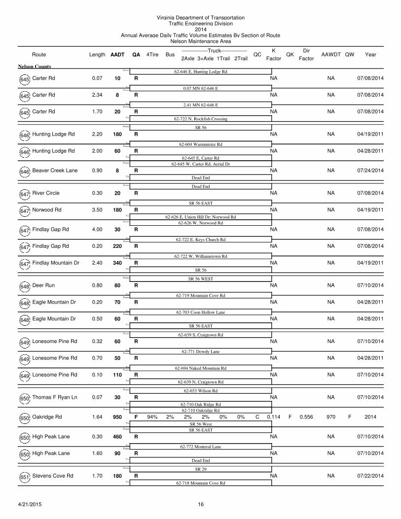
Carter Rd 10 NA NAR
62-646 E, Hunting Lodge Rd
0.07 MN 62-646 EFrom:
To:
From:
0.07
Nelson County
07/08/2014645
Carter Rd 8 NA NAR
2.41 MN 62-646 EFrom:
To:
2.34 07/08/2014645
Carter Rd 20 NA NAR
62-722 N, Rockfish CrossingTo:
1.70 07/08/2014645
Hunting Lodge Rd 180 NA NAR
SR 56
62-604 Warminister RdFrom:
To:
From:
2.20 04/19/2011646
Hunting Lodge Rd 60 NA NAR
62-645 E, Carter RdFrom:
To:
2.00 04/28/2011646
62-645 W, Carter Rd; Aerial Dr
Beaver Creek Lane 8 NA NAR
Dead EndTo:
0.90 07/24/2014646
River Circle 20 NA NAR
Dead End
SR 56 EASTFrom:
To:
From:
0.30 07/08/2014647
Norwood Rd 180 NA NAR
62-626 E, Union Hill Dr; Norwood RdFrom:
To:
3.50 04/19/2011647
62-626 W, Norwood Rd
Findlay Gap Rd 30 NA NAR
62-722 E, Keys Church RdFrom:
To:
4.00 07/08/2014647
Findlay Gap Rd 220 NA NAR
62-722 W, Williamstown RdFrom:
To:
0.20 07/08/2014647
Findlay Mountain Dr 340 NA NAR
SR 56To:
2.40 04/19/2011647
Deer Run 80 NA NAR
SR 56 WEST
62-719 Mountain Cove RdFrom:
To:
From:
0.80 07/10/2014648
Eagle Mountain Dr 70 NA NAR
62-703 Coon Hollow LaneFrom:
To:
0.20 04/28/2011648
Eagle Mountain Dr 60 NA NAR
SR 56 EASTTo:
0.50 04/28/2011648
Lonesome Pine Rd 60 NA NAR
62-639 S, Craigtown Rd
62-771 Dowdy LaneFrom:
To:
From:
0.32 07/10/2014649
Lonesome Pine Rd 50 NA NAR
62-694 Naked Mountain RdFrom:
To:
0.70 04/28/2011649
Lonesome Pine Rd 110 NA NAR
62-639 N, Craigtown RdTo:
0.10 07/10/2014649
Thomas F Ryan Ln 30 NA NAR
62-653 Wilson Rd
62-710 Oak Ridge RdFrom:
To:
From:
0.07 07/10/2014650
62-710 Oakridge Rd
Oakridge Rd 950 2% 2% 0.114 970F F2% 0% C F
SR 56 West
94%
From:
To:
1.64 0% 2014650
SR 56 EAST
0.556
High Peak Lane 460 NA NAR
62-772 Montreal LaneFrom:
To:
0.30 07/10/2014650
High Peak Lane 90 NA NAR
Dead EndTo:
1.60 07/10/2014650
Stevens Cove Rd 180 NA NAR
SR 29
62-718 Mountain Cove RdTo:
From:
1.70 07/22/2014651
164/21/2015
Virginia Department of TransportationTraffic Engineering Division
2014Annual Average Daily Traffic Volume Estimates By Section of Route
Nelson Maintenance Area
Route AADT1Trail 2Trail
4TireK
QA2Axle 3+Axle
QC QKBusLength---------------Truck---------------
FactorAAWDT QW Year
Dir
Factor
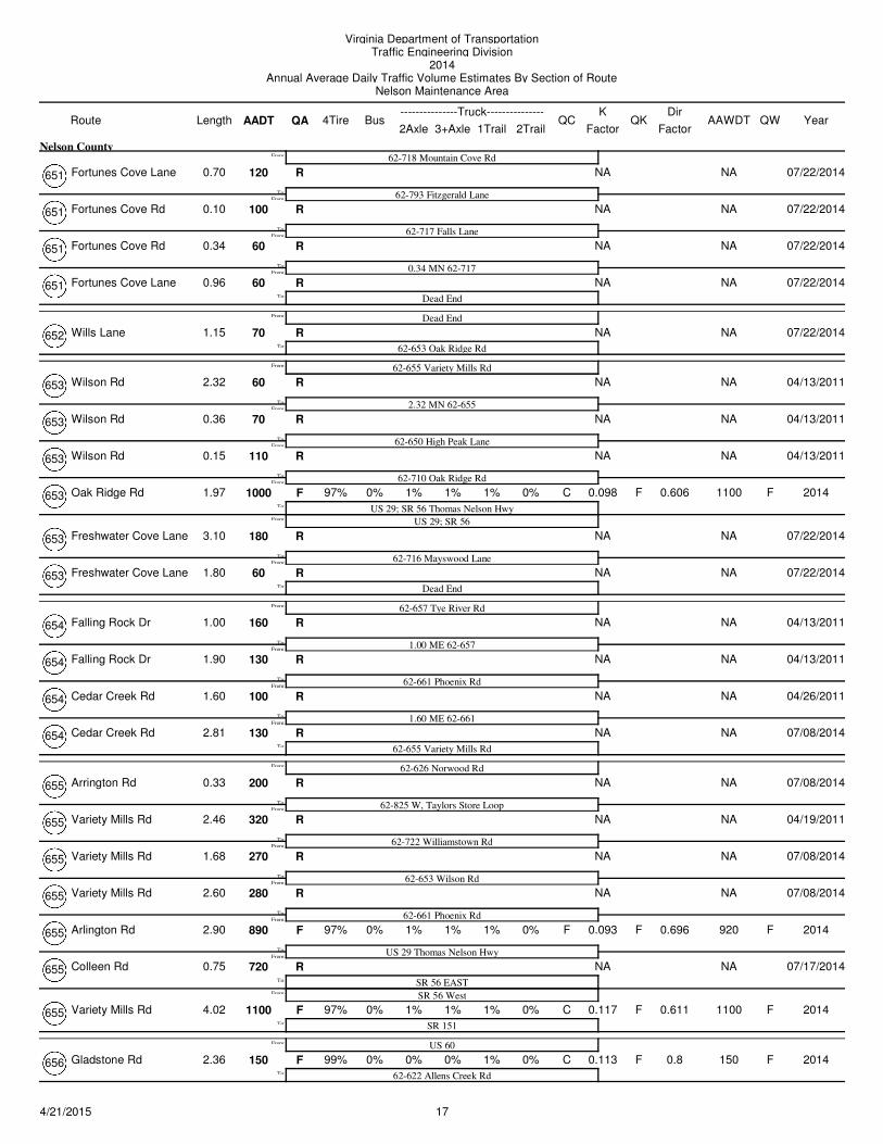
Fortunes Cove Lane 120 NA NAR
62-718 Mountain Cove Rd
62-793 Fitzgerald LaneFrom:
To:
From:
0.70
Nelson County
07/22/2014651
Fortunes Cove Rd 100 NA NAR
62-717 Falls LaneFrom:
To:
0.10 07/22/2014651
Fortunes Cove Rd 60 NA NAR
0.34 MN 62-717From:
To:
0.34 07/22/2014651
Fortunes Cove Lane 60 NA NAR
Dead EndTo:
0.96 07/22/2014651
Wills Lane 70 NA NAR
Dead End
62-653 Oak Ridge RdTo:
From:
1.15 07/22/2014652
Wilson Rd 60 NA NAR
62-655 Variety Mills Rd
2.32 MN 62-655From:
To:
From:
2.32 04/13/2011653
Wilson Rd 70 NA NAR
62-650 High Peak LaneFrom:
To:
0.36 04/13/2011653
Wilson Rd 110 NA NAR
62-710 Oak Ridge RdFrom:
To:
0.15 04/13/2011653
Oak Ridge Rd 1000 0% 1% 0.098 1100F F1% 1% C F
US 29; SR 56 Thomas Nelson Hwy
97%
From:
To:
1.97 0% 2014653
US 29; SR 56
0.606
Freshwater Cove Lane 180 NA NAR
62-716 Mayswood LaneFrom:
To:
3.10 07/22/2014653
Freshwater Cove Lane 60 NA NAR
Dead EndTo:
1.80 07/22/2014653
Falling Rock Dr 160 NA NAR
62-657 Tye River Rd
1.00 ME 62-657From:
To:
From:
1.00 04/13/2011654
Falling Rock Dr 130 NA NAR
62-661 Phoenix RdFrom:
To:
1.90 04/13/2011654
Cedar Creek Rd 100 NA NAR
1.60 ME 62-661From:
To:
1.60 04/26/2011654
Cedar Creek Rd 130 NA NAR
62-655 Variety Mills RdTo:
2.81 07/08/2014654
Arrington Rd 200 NA NAR
62-626 Norwood Rd
62-825 W, Taylors Store LoopFrom:
To:
From:
0.33 07/08/2014655
Variety Mills Rd 320 NA NAR
62-722 Williamstown RdFrom:
To:
2.46 04/19/2011655
Variety Mills Rd 270 NA NAR
62-653 Wilson RdFrom:
To:
1.68 07/08/2014655
Variety Mills Rd 280 NA NAR
62-661 Phoenix RdFrom:
To:
2.60 07/08/2014655
Arlington Rd 890 0% 1% 0.093 920F F1% 1% F F
US 29 Thomas Nelson Hwy
97%
From:
To:
2.90 0% 2014655 0.696
Colleen Rd 720 NA NAR
SR 56 EASTFrom:
To:
0.75 07/17/2014655
SR 56 West
Variety Mills Rd 1100 0% 1% 0.117 1100F F1% 1% C F
SR 151
97%To:
4.02 0% 2014655 0.611
Gladstone Rd 150 0% 0% 0.113 150F F0% 1% C F
US 60
62-622 Allens Creek Rd
99%To:
From:
2.36 0% 2014656 0.8
174/21/2015
Virginia Department of TransportationTraffic Engineering Division
2014Annual Average Daily Traffic Volume Estimates By Section of Route
Nelson Maintenance Area
Route AADT1Trail 2Trail
4TireK
QA2Axle 3+Axle
QC QKBusLength---------------Truck---------------
FactorAAWDT QW Year
Dir
Factor
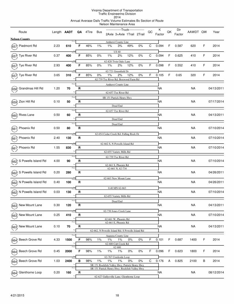
Piedmont Rd 610 1% 1% 0.094 620F F3% 49% C F
Amherst County Line
US 60
46%
From:To:
From:
2.23 0%
Nelson County
2014657 0.587
Tye River Rd 400 0% 1% 0.094 410F F2% 12% C F
62-820 Twin Oaks Lane
85%
From:
To:
0.37 0% 2014657 0.625
Tye River Rd 400 0% 1% 0.098 410F F2% 12% F F
62-721 Greenfield Dr
85%
From:To:
2.93 0% 2014657 0.552
Tye River Rd 310 0% 1% 0.105 320F F2% 12% F F
62-739 Tye River Rd; Boxwood Farm Rd
85%To:
3.65 0% 2014657 0.65
Grandmas Hill Rd 70 NA NAR
Amherst County Line
62-657 Tye River RdTo:
From:
1.20 04/13/2011658
Zion Hill Rd 50 NA NAR
SR 151 Patrick Henry Hwy
Dead EndTo:
From:
0.10 07/17/2014659
Rives Lane 60 NA NAR
62-657 Tye River Rd
Dead EndTo:
From:
0.50 04/13/2011660
Phoenix Rd 80 NA NAR
Dead End
62-654 Cedar Creek Rd; Falling Rock DrFrom:
To:
From:
0.50 07/10/2014661
Phoenix Rd 130 NA NAR
62-662 S, N Powells Island RdFrom:
To:
2.40 07/10/2014661
Phoenix Rd 830 NA NAR
62-655 Variety Mills RdTo:
1.55 07/10/2014661
S Powells Island Rd 90 NA NAR
62-739 Tye River Rd
62-661 S, Phoenix RdFrom:
To:
From:
4.00 07/10/2014662
62-661 N, 62-734
S Powells Island Rd 280 NA NAR
62-663 New Mount LaneFrom:
To:
0.20 04/26/2011662
N Powells Island Rd 100 NA NAR
0.40 MN 62-663From:
To:
0.40 04/26/2011662
N Powells Island Rd 130 NA NAR
62-655 Variety Mills RdTo:
0.03 07/10/2014662
New Mount Lane 120 NA NAR
Dead End
62-730 Jones Creek LaneFrom:
To:
From:
0.30 04/13/2011663
New Mount Lane 410 NA NAR
62-661 W, Phoenix RdFrom:
To:
0.25 07/10/2014663
62-661 E, Phoenix Rd
New Mount Lane 70 NA NAR
62-662, N Powells Island Rd; S Powells Island RdTo:
0.10 04/13/2011663
Beech Grove Rd 1500 1% 1% 0.101 1400F F1% 0% F F
Augusta County Line
62-680 Cub Creek Rd
98%
From:
To:
From:
4.33 0% 2014664
62 680
0.687
Beech Grove Rd 2000 1% 1% 0.096 1800F F1% 0% F F
62-767 Creekside Loop
98%
From:
To:
0.45 0% 2014664 0.623
Beech Grove Rd 2400 1% 1% 0.176 2100B A1% 0% C B
SR 151 Rockfish Valley Hwy; Patrick Henry Hwy
98%
From:
To:
1.03 0% 2014664
SR 151 Patrick Henry Hwy; Rockfish Valley Hwy
0.825
Glenthorne Loop 160 NA NAR
62-627 Gullysville Lane; Glenthorne LoopTo:
0.20 08/12/2014664
184/21/2015
Virginia Department of TransportationTraffic Engineering Division
2014Annual Average Daily Traffic Volume Estimates By Section of Route
Nelson Maintenance Area
Route AADT1Trail 2Trail
4TireK
QA2Axle 3+Axle
QC QKBusLength---------------Truck---------------
FactorAAWDT QW Year
Dir
Factor
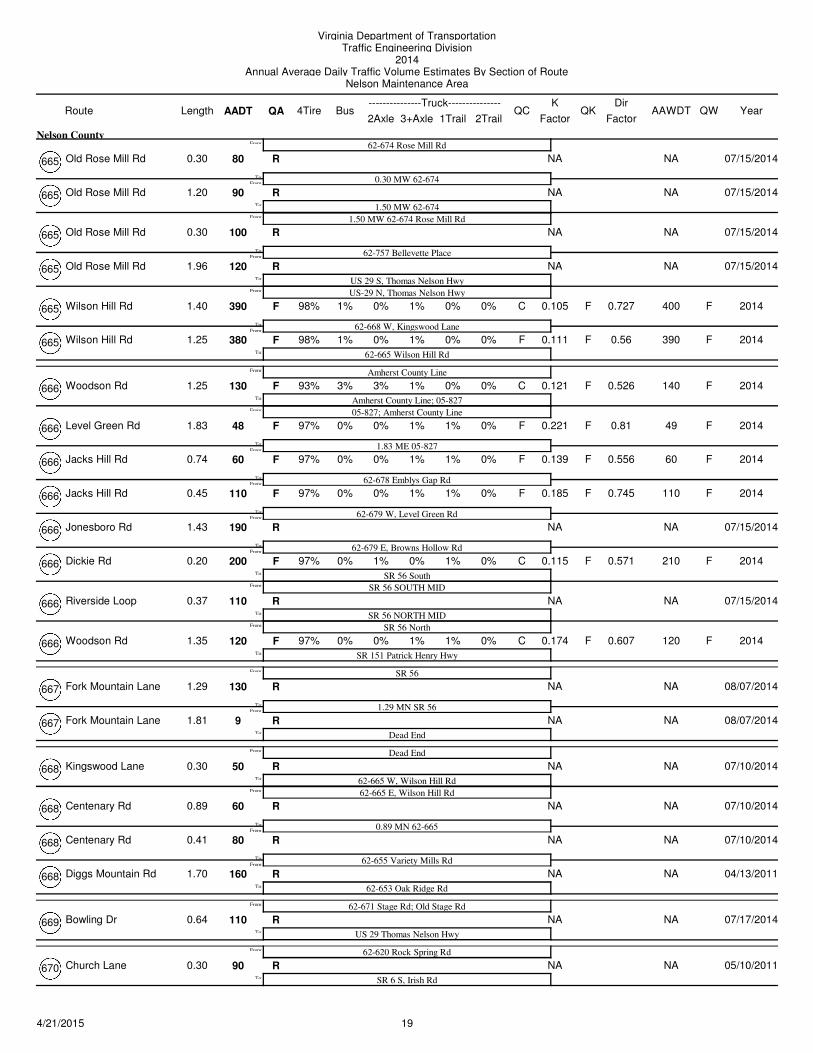
Old Rose Mill Rd 80 NA NAR
62-674 Rose Mill Rd
0.30 MW 62-674From:
To:
From:
0.30
Nelson County
07/15/2014665
Old Rose Mill Rd 90 NA NAR
1.50 MW 62-674From:
To:
1.20 07/15/2014665
1.50 MW 62-674 Rose Mill Rd
Old Rose Mill Rd 100 NA NAR
62-757 Bellevette PlaceFrom:
To:
0.30 07/15/2014665
Old Rose Mill Rd 120 NA NAR
US 29 S, Thomas Nelson HwyFrom:
To:
1.96 07/15/2014665
US-29 N, Thomas Nelson Hwy
Wilson Hill Rd 390 1% 0% 0.105 400F F1% 0% C F
62-668 W, Kingswood Lane
98%
From:
To:
1.40 0% 2014665 0.727
Wilson Hill Rd 380 1% 0% 0.111 390F F1% 0% F F
62-665 Wilson Hill Rd
98%To:
1.25 0% 2014665 0.56
Woodson Rd 130 3% 3% 0.121 140F F1% 0% C F
Amherst County Line
Amherst County Line; 05-827
93%
From:
To:
From:
1.25 0% 2014666
05-827; Amherst County Line
0.526
Level Green Rd 48 0% 0% 0.221 49F F1% 1% F F
1.83 ME 05-827
97%
From:
To:
1.83 0% 2014666 0.81
Jacks Hill Rd 60 0% 0% 0.139 60F F1% 1% F F
62-678 Emblys Gap Rd
97%
From:To:
0.74 0% 2014666 0.556
Jacks Hill Rd 110 0% 0% 0.185 110F F1% 1% F F
62-679 W, Level Green Rd
97%
From:To:
0.45 0% 2014666 0.745
Jonesboro Rd 190 NA NAR
62-679 E, Browns Hollow RdFrom:
To:
1.43 07/15/2014666
Dickie Rd 200 0% 1% 0.115 210F F0% 1% C F
SR 56 South
97%
From:
To:
0.20 0% 2014666
SR 56 SOUTH MID
0.571
Riverside Loop 110 NA NAR
SR 56 NORTH MIDFrom:
To:
0.37 07/15/2014666
SR 56 North
Woodson Rd 120 0% 0% 0.174 120F F1% 1% C F
SR 151 Patrick Henry Hwy
97%To:
1.35 0% 2014666 0.607
Fork Mountain Lane 130 NA NAR
SR 56
1.29 MN SR 56From:
To:
From:
1.29 08/07/2014667
Fork Mountain Lane 9 NA NAR
Dead EndTo:
1.81 08/07/2014667
Kingswood Lane 50 NA NAR
Dead End
62-665 W, Wilson Hill RdFrom:
To:
From:
0.30 07/10/2014668
62-665 E, Wilson Hill Rd
Centenary Rd 60 NA NAR
0.89 MN 62-665From:
To:
0.89 07/10/2014668
Centenary Rd 80 NA NAR
62-655 Variety Mills RdFrom:
To:
0.41 07/10/2014668
Diggs Mountain Rd 160 NA NAR
62-653 Oak Ridge RdTo:
1.70 04/13/2011668
Bowling Dr 110 NA NAR
62-671 Stage Rd; Old Stage Rd
US 29 Thomas Nelson HwyTo:
From:
0.64 07/17/2014669
Church Lane 90 NA NAR
62-620 Rock Spring Rd
SR 6 S, Irish RdTo:
From:
0.30 05/10/2011670
194/21/2015
Virginia Department of TransportationTraffic Engineering Division
2014Annual Average Daily Traffic Volume Estimates By Section of Route
Nelson Maintenance Area
Route AADT1Trail 2Trail
4TireK
QA2Axle 3+Axle
QC QKBusLength---------------Truck---------------
FactorAAWDT QW Year
Dir
Factor
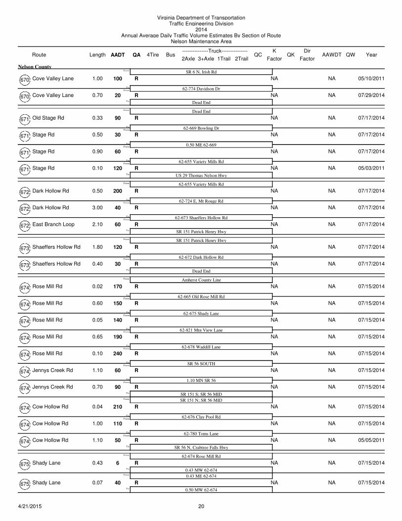
Cove Valley Lane 100 NA NAR
SR 6 N, Irish Rd
62-774 Davidson DrFrom:
To:
From:
1.00
Nelson County
05/10/2011670
Cove Valley Lane 20 NA NAR
Dead EndTo:
0.70 07/29/2014670
Old Stage Rd 90 NA NAR
Dead End
62-669 Bowling DrFrom:
To:
From:
0.33 07/17/2014671
Stage Rd 30 NA NAR
0.50 ME 62-669From:
To:
0.50 07/17/2014671
Stage Rd 60 NA NAR
62-655 Variety Mills RdFrom:
To:
0.90 07/17/2014671
Stage Rd 120 NA NAR
US 29 Thomas Nelson HwyTo:
0.10 05/03/2011671
Dark Hollow Rd 200 NA NAR
62-655 Variety Mills Rd
62-724 E, Mt Rouge RdFrom:
To:
From:
0.50 07/17/2014672
Dark Hollow Rd 40 NA NAR
62-673 Shaeffers Hollow RdFrom:
To:
3.00 07/17/2014672
East Branch Loop 60 NA NAR
SR 151 Patrick Henry HwyTo:
2.10 07/17/2014672
Shaeffers Hollow Rd 120 NA NAR
SR 151 Patrick Henry Hwy
62-672 Dark Hollow RdFrom:
To:
From:
1.80 07/17/2014673
Shaeffers Hollow Rd 30 NA NAR
Dead EndTo:
0.40 07/17/2014673
Rose Mill Rd 170 NA NAR
Amherst County Line
62-665 Old Rose Mill RdFrom:
To:
From:
0.02 07/15/2014674
Rose Mill Rd 150 NA NAR
62-675 Shady LaneFrom:
To:
0.60 07/15/2014674
Rose Mill Rd 140 NA NAR
62-821 Mtn View LaneFrom:
To:
0.05 07/15/2014674
Rose Mill Rd 190 NA NAR
62-678 Waddill LaneFrom:
To:
0.65 07/15/2014674
Rose Mill Rd 240 NA NAR
SR 56 SOUTHFrom:
To:
0.10 07/15/2014674
Jennys Creek Rd 60 NA NAR
1.10 MN SR 56From:
To:
1.10 07/15/2014674
Jennys Creek Rd 90 NA NAR
SR 151 S; SR 56 MIDFrom:
To:
0.70 07/15/2014674
SR 151 N; SR 56 MID
Cow Hollow Rd 210 NA NAR
62-676 Clay Pool RdFrom:
To:
0.04 07/15/2014674
Cow Hollow Rd 110 NA NAR
62-780 Toms LaneFrom:
To:
1.00 07/15/2014674
Cow Hollow Rd 50 NA NAR
SR 56 N, Crabtree Falls HwyTo:
1.10 05/05/2011674
Shady Lane 6 NA NAR
62-674 Rose Mill Rd
0.43 MW 62-674From:
To:
From:
0.43 07/15/2014675
0.43 ME 62-674
Shady Lane 40 NA NAR
0.50 MW 62-674To:
0.07 07/15/2014675
204/21/2015
Virginia Department of TransportationTraffic Engineering Division
2014Annual Average Daily Traffic Volume Estimates By Section of Route
Nelson Maintenance Area
Route AADT1Trail 2Trail
4TireK
QA2Axle 3+Axle
QC QKBusLength---------------Truck---------------
FactorAAWDT QW Year
Dir
Factor
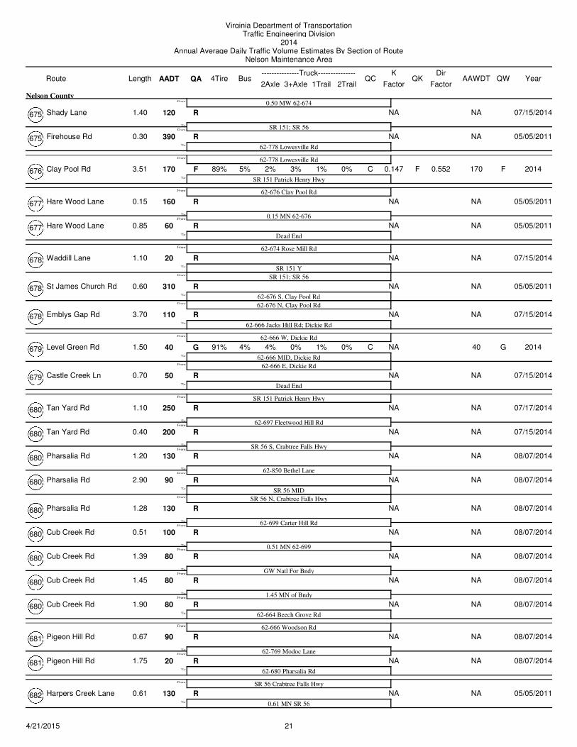
Shady Lane 120 NA NAR
0.50 MW 62-674
SR 151; SR 56From:
To:
From:
1.40
Nelson County
07/15/2014675
Firehouse Rd 390 NA NAR
62-778 Lowesville RdTo:
0.30 05/05/2011675
Clay Pool Rd 170 5% 2% 0.147 170F F3% 1% C F
62-778 Lowesville Rd
SR 151 Patrick Henry Hwy
89%To:
From:
3.51 0% 2014676 0.552
Hare Wood Lane 160 NA NAR
62-676 Clay Pool Rd
0.15 MN 62-676From:
To:
From:
0.15 05/05/2011677
Hare Wood Lane 60 NA NAR
Dead EndTo:
0.85 05/05/2011677
Waddill Lane 20 NA NAR
62-674 Rose Mill Rd
SR 151 YFrom:
To:
From:
1.10 07/15/2014678
SR 151; SR 56
St James Church Rd 310 NA NAR
62-676 S, Clay Pool RdFrom:
To:
0.60 05/05/2011678
62-676 N, Clay Pool Rd
Emblys Gap Rd 110 NA NAR
62-666 Jacks Hill Rd; Dickie RdTo:
3.70 07/15/2014678
Level Green Rd 40 4% 4% NA 40G 0% 1% C G
62-666 W, Dickie Rd
62-666 MID, Dickie Rd
91%
From:
To:
From:
1.50 0% 2014679
62-666 E, Dickie Rd
Castle Creek Ln 50 NA NAR
Dead EndTo:
0.70 07/15/2014679
Tan Yard Rd 250 NA NAR
SR 151 Patrick Henry Hwy
62-697 Fleetwood Hill RdFrom:
To:
From:
1.10 07/17/2014680
Tan Yard Rd 200 NA NAR
SR 56 S, Crabtree Falls HwyFrom:
To:
0.40 07/15/2014680
Pharsalia Rd 130 NA NAR
62-850 Bethel LaneFrom:
To:
1.20 08/07/2014680
Pharsalia Rd 90 NA NAR
SR 56 MIDFrom:
To:
2.90 08/07/2014680
SR 56 N, Crabtree Falls Hwy
Pharsalia Rd 130 NA NAR
62-699 Carter Hill RdFrom:
To:
1.28 08/07/2014680
Cub Creek Rd 100 NA NAR
0.51 MN 62-699From:
To:
0.51 08/07/2014680
Cub Creek Rd 80 NA NAR
GW Natl For BndyFrom:
To:
1.39 08/07/2014680
Cub Creek Rd 80 NA NAR
1.45 MN of BndyFrom:
To:
1.45 08/07/2014680
Cub Creek Rd 80 NA NAR
62-664 Beech Grove RdTo:
1.90 08/07/2014680
Pigeon Hill Rd 90 NA NAR
62-666 Woodson Rd
62-769 Modoc LaneFrom:
To:
From:
0.67 08/07/2014681
Pigeon Hill Rd 20 NA NAR
62-680 Pharsalia RdTo:
1.75 08/07/2014681
Harpers Creek Lane 130 NA NAR
SR 56 Crabtree Falls Hwy
0.61 MN SR 56To:
From:
0.61 05/05/2011682
214/21/2015
Virginia Department of TransportationTraffic Engineering Division
2014Annual Average Daily Traffic Volume Estimates By Section of Route
Nelson Maintenance Area
Route AADT1Trail 2Trail
4TireK
QA2Axle 3+Axle
QC QKBusLength---------------Truck---------------
FactorAAWDT QW Year
Dir
Factor
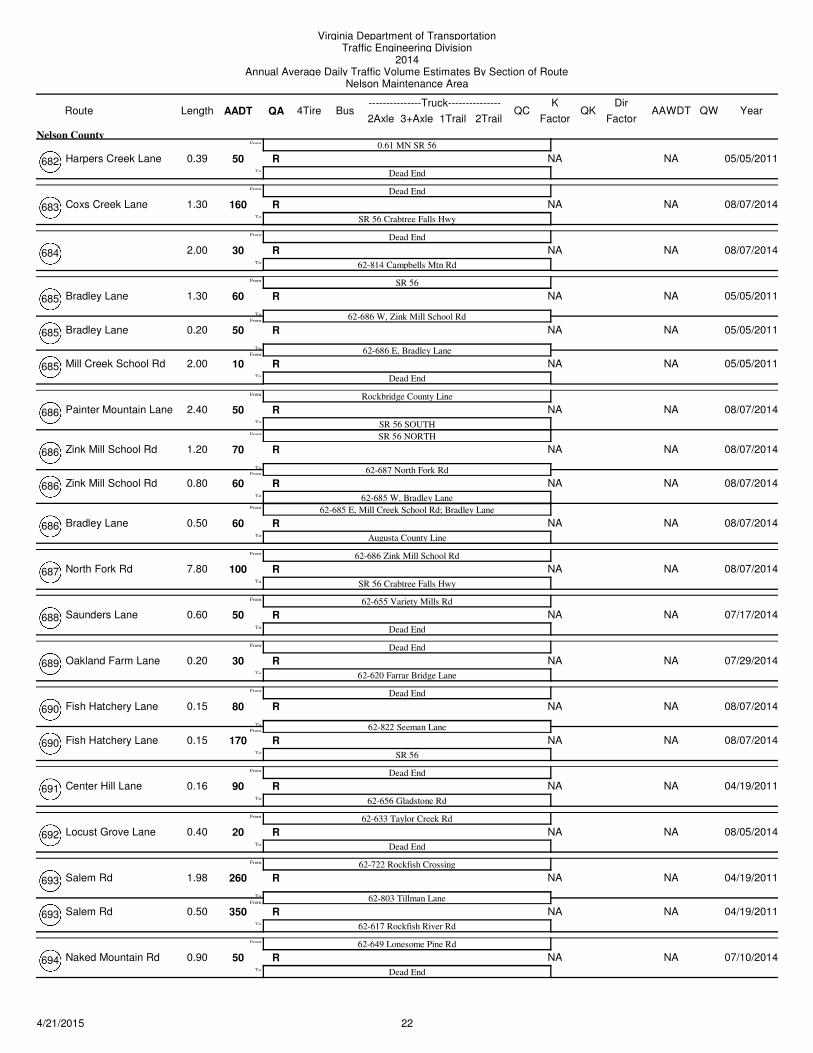
Harpers Creek Lane 50 NA NAR
0.61 MN SR 56
Dead EndTo:
From:
0.39
Nelson County
05/05/2011682
Coxs Creek Lane 160 NA NAR
Dead End
SR 56 Crabtree Falls HwyTo:
From:
1.30 08/07/2014683
30 NA NAR
Dead End
62-814 Campbells Mtn RdTo:
From:
2.00 08/07/2014684
Bradley Lane 60 NA NAR
SR 56
62-686 W, Zink Mill School RdFrom:
To:
From:
1.30 05/05/2011685
Bradley Lane 50 NA NAR
62-686 E, Bradley LaneFrom:
To:
0.20 05/05/2011685
Mill Creek School Rd 10 NA NAR
Dead EndTo:
2.00 05/05/2011685
Painter Mountain Lane 50 NA NAR
Rockbridge County Line
SR 56 SOUTHFrom:
To:
From:
2.40 08/07/2014686
SR 56 NORTH
Zink Mill School Rd 70 NA NAR
62-687 North Fork RdFrom:
To:
1.20 08/07/2014686
Zink Mill School Rd 60 NA NAR
62-685 W, Bradley LaneFrom:
To:
0.80 08/07/2014686
62-685 E, Mill Creek School Rd; Bradley Lane
Bradley Lane 60 NA NAR
Augusta County LineTo:
0.50 08/07/2014686
North Fork Rd 100 NA NAR
62-686 Zink Mill School Rd
SR 56 Crabtree Falls HwyTo:
From:
7.80 08/07/2014687
Saunders Lane 50 NA NAR
62-655 Variety Mills Rd
Dead EndTo:
From:
0.60 07/17/2014688
Oakland Farm Lane 30 NA NAR
Dead End
62-620 Farrar Bridge LaneTo:
From:
0.20 07/29/2014689
Fish Hatchery Lane 80 NA NAR
Dead End
62-822 Seeman LaneFrom:
To:
From:
0.15 08/07/2014690
Fish Hatchery Lane 170 NA NAR
SR 56To:
0.15 08/07/2014690
Center Hill Lane 90 NA NAR
Dead End
62-656 Gladstone RdTo:
From:
0.16 04/19/2011691
Locust Grove Lane 20 NA NAR
62-633 Taylor Creek Rd
Dead EndTo:
From:
0.40 08/05/2014692
Salem Rd 260 NA NAR
62-722 Rockfish Crossing
62-803 Tillman LaneFrom:
To:
From:
1.98 04/19/2011693
Salem Rd 350 NA NAR
62-617 Rockfish River RdTo:
0.50 04/19/2011693
Naked Mountain Rd 50 NA NAR
62-649 Lonesome Pine Rd
Dead EndTo:
From:
0.90 07/10/2014694
224/21/2015
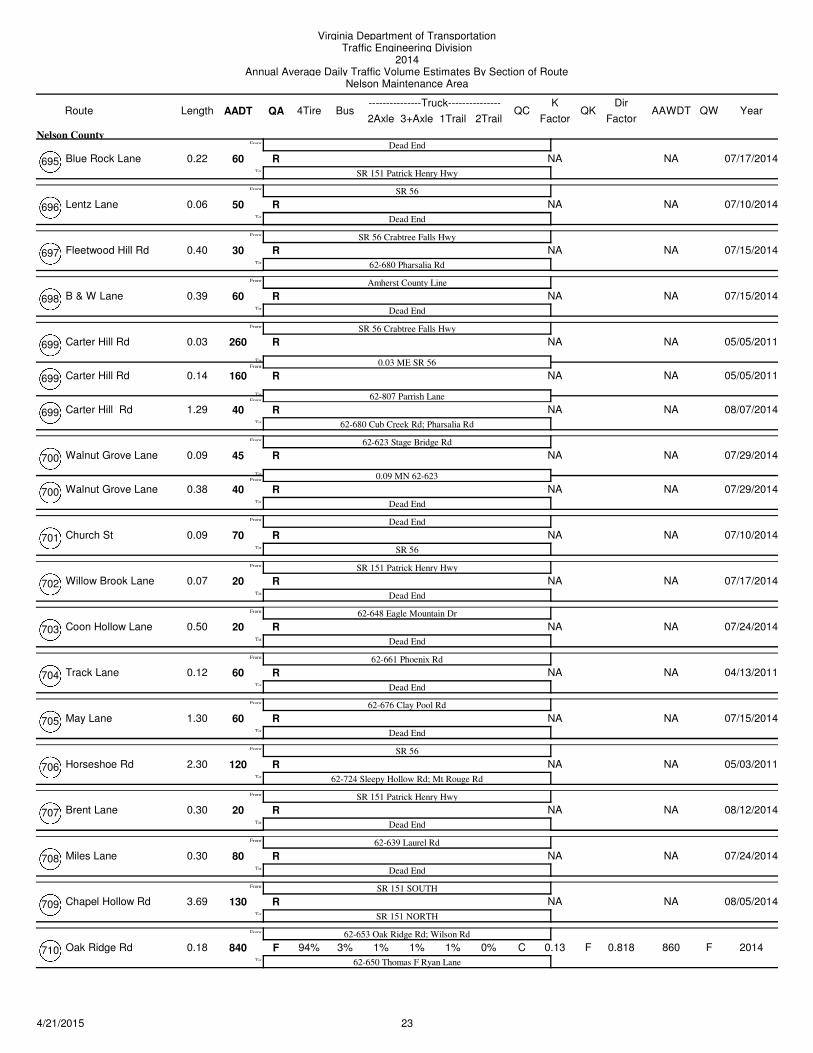
Virginia Department of TransportationTraffic Engineering Division
2014Annual Average Daily Traffic Volume Estimates By Section of Route
Nelson Maintenance Area
Route AADT1Trail 2Trail
4TireK
QA2Axle 3+Axle
QC QKBusLength---------------Truck---------------
FactorAAWDT QW Year
Dir
Factor
Blue Rock Lane 60 NA NAR
Dead End
SR 151 Patrick Henry HwyTo:
From:
0.22
Nelson County
07/17/2014695
Lentz Lane 50 NA NAR
SR 56
Dead EndTo:
From:
0.06 07/10/2014696
Fleetwood Hill Rd 30 NA NAR
SR 56 Crabtree Falls Hwy
62-680 Pharsalia RdTo:
From:
0.40 07/15/2014697
B & W Lane 60 NA NAR
Amherst County Line
Dead EndTo:
From:
0.39 07/15/2014698
Carter Hill Rd 260 NA NAR
SR 56 Crabtree Falls Hwy
0.03 ME SR 56From:
To:
From:
0.03 05/05/2011699
Carter Hill Rd 160 NA NAR
62-807 Parrish LaneFrom:
To:
0.14 05/05/2011699
Carter Hill Rd 40 NA NAR
62-680 Cub Creek Rd; Pharsalia RdTo:
1.29 08/07/2014699
Walnut Grove Lane 45 NA NAR
62-623 Stage Bridge Rd
0.09 MN 62-623From:
To:
From:
0.09 07/29/2014700
Walnut Grove Lane 40 NA NAR
Dead EndTo:
0.38 07/29/2014700
Church St 70 NA NAR
Dead End
SR 56To:
From:
0.09 07/10/2014701
Willow Brook Lane 20 NA NAR
SR 151 Patrick Henry Hwy
Dead EndTo:
From:
0.07 07/17/2014702
Coon Hollow Lane 20 NA NAR
62-648 Eagle Mountain Dr
Dead EndTo:
From:
0.50 07/24/2014703
Track Lane 60 NA NAR
62-661 Phoenix Rd
Dead EndTo:
From:
0.12 04/13/2011704
May Lane 60 NA NAR
62-676 Clay Pool Rd
Dead EndTo:
From:
1.30 07/15/2014705
Horseshoe Rd 120 NA NAR
SR 56
62-724 Sleepy Hollow Rd; Mt Rouge RdTo:
From:
2.30 05/03/2011706
Brent Lane 20 NA NAR
SR 151 Patrick Henry Hwy
Dead EndTo:
From:
0.30 08/12/2014707
Miles Lane 80 NA NAR
62-639 Laurel Rd
Dead EndTo:
From:
0.30 07/24/2014708
Chapel Hollow Rd 130 NA NAR
SR 151 SOUTH
SR 151 NORTHTo:
From:
3.69 08/05/2014709
Oak Ridge Rd 840 3% 1% 0.13 860F F1% 1% C F
62-653 Oak Ridge Rd; Wilson Rd
62-650 Thomas F Ryan Lane
94%To:
From:
0.18 0% 2014710 0.818
234/21/2015
Virginia Department of TransportationTraffic Engineering Division
2014Annual Average Daily Traffic Volume Estimates By Section of Route
Nelson Maintenance Area
Route AADT1Trail 2Trail
4TireK
QA2Axle 3+Axle
QC QKBusLength---------------Truck---------------
FactorAAWDT QW Year
Dir
Factor
Orchard Rd 210 NA NAR
Bus US 29
62-1001 Court StFrom:
To:
From:
0.31
Nelson County
07/22/2014711
Orchard Rd 70 NA NAR
62-1004 Bridge StTo:
0.11 07/22/2014711
Battery Hill Lane 120 NA NAR
SR 56 Crabtree Falls Hwy
0.07 MN SR 56From:
To:
From:
0.07 05/05/2011712
Battery Hill Lane 100 NA NAR
Dead EndTo:
0.30 05/05/2011712
Braddock Lane 20 NA NAR
Dead End
0.03 MN 62-9431From:
To:
From:
0.29 07/10/2014713
Braddock Lane 130 NA NAR
62-650 High Peak LaneTo:
0.23 07/10/2014713
Drumheller Lane 30 NA NAR
Dead End
62-617 Rockfish River RdTo:
From:
0.60 07/29/2014714
Moses Hughes Lane 80 NA NAR
62-664 Beech Grove Rd
Dead EndTo:
From:
0.39 05/05/2011715
Mayswood Lane 60 NA NAR
62-653 Freshwater Cove Lane; Oak Ridge Rd
Dead EndTo:
From:
1.00 07/22/2014716
Falls Lane 20 NA NAR
62-651 Fortunes Cove Rd
Dead EndTo:
From:
0.90 07/22/2014717
Mountain Cove Rd 210 NA NAR
62-651 Fortunes Cove Lane
US 29 Thomas Nelson HwyTo:
From:
1.56 07/22/2014718
Mountain Cove Rd 90 NA NAR
62-648 Eagle Mountain Dr; Deer Run
1.62 MN 62-648From:
To:
From:
1.62 07/24/2014719
Mountain Cove Rd 110 NA NAR
62-639 Laurel Rd; Craigtown RdTo:
0.08 07/24/2014719
Farrar Lane 270 NA NAR
62-665 Wilson Hill Rd
62-655 Variety Mills RdTo:
From:
0.15 04/13/2011720
Greenfield Dr 60 NA NAR
62-657 Tye River Rd
0.07 ME 62-657From:
To:
From:
0.07 04/26/2011721
Greenfield Dr 50 NA NAR
62-626 Norwood RdTo:
4.23 04/26/2011721
Williamstown Rd 320 NA NAR
62-655 Variety Mills Rd
62-647 W, Findlay Mountain Dr; Findlay Gap RdFrom:
To:
From:
2.10 04/19/2011722
62-647 E, Findlay Gap Rd
Keys Church Rd 120 NA NAR
SR 56From:
To:
2.40 07/08/2014722
Glade Rd 210 NA NAR
62-830 Piney Mountain PlaceFrom:
To:
2.30 07/24/2014722
Glade Rd 200 NA NAR
62-645 S, Aerial DrFrom:
To:
1.10 07/24/2014722
Rockfish Crossing 260 NA NAR
Albemarle County LineTo:
4.60 04/19/2011722
244/21/2015
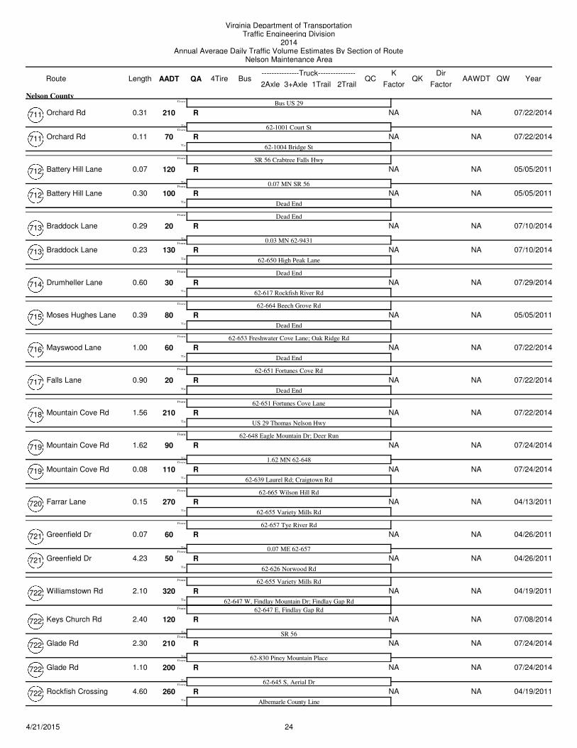
Virginia Department of TransportationTraffic Engineering Division
2014Annual Average Daily Traffic Volume Estimates By Section of Route
Nelson Maintenance Area
Route AADT1Trail 2Trail
4TireK
QA2Axle 3+Axle
QC QKBusLength---------------Truck---------------
FactorAAWDT QW Year
Dir
Factor
Old Roseland Rd 60 NA NAR
62-655 Variety Mills Rd
SR 151 Patrick Henry HwyTo:
From:
0.87
Nelson County
07/17/2014723
Mt Rouge Rd 110 NA NAR
62-655 W, Variety Mills Rd
0.34 ME 62-655From:
To:
From:
0.34 07/17/2014724
Mount Rouge Rd 10 NA NAR
62-672 W, Dark Hollow RdFrom:
To:
0.36 07/17/2014724
62-672 E, Dark Hollow Rd
Sleepy Hollow Rd 70 NA NAR
62-706 Horseshoe RdFrom:
To:
2.00 07/17/2014724
Sleepy Hollow Rd 170 NA NAR
62-655 E, Variety Mills RdTo:
0.20 05/03/2011724
Cat Rock Mountain Lane 60 NA NAR
SR 151 Patrick Henry Hwy
Dead EndTo:
From:
0.80 07/17/2014725
Donahue Lane 80 NA NAR
SR 151 Patrick Henry Hwy
Dead EndTo:
From:
0.60 07/17/2014726
Capel Lane 10 NA NAR
Dead End
62-626 Norwood RdFrom:
To:
From:
0.15 04/19/2011727
Pine Hill Lane 30 NA NAR
Dead EndTo:
0.05 04/19/2011727
Durrett Town Rd 160 NA NAR
Dead End
62-636 Batesville RdTo:
From:
1.25 08/05/2014728
Creek Rd 50 NA NAR
Dead End
SR 151To:
From:
0.45 08/05/2014729
Jones Creek Lane 150 NA NAR
Dead End
62-823 Radford LaneFrom:
To:
From:
0.38 04/13/2011730
Jones Creek Lane 240 NA NAR
62-663 New Mount LaneTo:
0.07 04/13/2011730
Hubbards Hill Lane 120 NA NAR
Dead End
62-655 Variety Mills RdTo:
From:
1.00 07/17/2014731
Harlow Lane 70 NA NAR
Dead End
62-655 Variety Mills RdTo:
From:
0.70 04/26/2011732
Harvey Rd 70 NA NAR
US 29 Thomas Nelson Hwy
0.50 MW US 29From:
To:
From:
0.50 05/03/2011733
Harvey Rd 50 NA NAR
0.60 MW US 29From:
To:
0.10 05/03/2011733
Harvey Rd 30 NA NAR
Dead EndTo:
0.28 05/03/2011733
Lobo Lane 80 NA NAR
Dead End
62-835 Turner LaneFrom:
To:
From:
0.52 04/13/2011734
Lobo Lane 220 NA NAR
62-661; 62-662To:
0.33 04/13/2011734
Nelmonte Lane 70 NA NAR
62-739 Tye River Rd
Dead EndTo:
From:
0.41 04/13/2011735
254/21/2015
Virginia Department of TransportationTraffic Engineering Division
2014Annual Average Daily Traffic Volume Estimates By Section of Route
Nelson Maintenance Area
Route AADT1Trail 2Trail
4TireK
QA2Axle 3+Axle
QC QKBusLength---------------Truck---------------
FactorAAWDT QW Year
Dir
Factor
Towler Way 100 NA NAR
Dead End
62-638 Avon RdTo:
From:
0.10
Nelson County
08/05/2014736
Ponton Lane 110 NA NAR
Dead End
US 29 Thomas Nelson HwyTo:
From:
0.85 07/31/2014737
Gunter Hollow Lane 70 NA NAR
62-724 Mount Rouge Rd
Dead EndTo:
From:
0.35 05/05/2011738
Boxwood Farm Rd 330 NA NAR
Amherst County Line
62-657 Tye River RdFrom:
To:
From:
0.30 04/13/2011739
Tye River Rd 710 2% 2% 0.122 730F F0% 1% C F
US 29 S, Thomas Nelson Hwy
95%
From:To:
2.14 0% 2014739 0.663
Napier Loop 70 NA NAR
0.18 MN US 29From:
To:
0.18 04/13/2011739
Napier Loop 80 NA NAR
0.40 MN US 29From:
To:
0.22 04/13/2011739
Napier Loop 70 NA NAR
US 29 N, Thomas Nelson HwyTo:
0.05 04/13/2011739
Clarks Hill Lane 70 NA NAR
62-800 Schuyler Rd
Dead EndTo:
From:
0.45 07/24/2014740
Drumheller Orchard Lane 510 NA NAR
US 29 Thomas Nelson Hwy
62-811 League LaneFrom:
To:
From:
0.49 05/10/2011741
Drumheller Orchard Lane 140 NA NAR
0.09 MN 62-811From:
To:
0.09 05/10/2011741
Drumheller Orchard Lane 100 NA NAR
Dead EndTo:
0.60 05/10/2011741
Old Ridge Rd 80 NA NAR
Dead End
62-786 Woods Mill RdTo:
From:
0.15 05/12/2011742
Midway Mills Lane 100 NA NAR
1.30 MS 62-626
62-626 James River RdFrom:
To:
From:
1.30 04/28/2011743
Mayo Creek Lane 90 NA NAR
Dead EndTo:
1.40 04/28/2011743
Randolph Lane 60 NA NAR
Dead End
62-722 Rockfish CrossingTo:
From:
0.60 04/19/2011744
Lake View Lane 100 NA NAR
Dead End
SR 56To:
From:
0.50 07/24/2014745
Simpsons Lane 40 NA NAR
Dead End
62-623 Stage Bridge RdTo:
From:
0.50 07/29/2014746
Marietta Lane 10 NA NAR
Dead End
62-639 Nelson AveFrom:
To:
From:
0.10 07/10/2014747
Marietta Lane 50 NA NAR
Dead EndTo:
0.10 07/10/2014747
Morse Lane 80 NA NAR
US 29 Thomas Nelson Hwy
Dead EndTo:
From:
0.92 04/26/2011748
264/21/2015
Virginia Department of TransportationTraffic Engineering Division
2014Annual Average Daily Traffic Volume Estimates By Section of Route
Nelson Maintenance Area
Route AADT1Trail 2Trail
4TireK
QA2Axle 3+Axle
QC QKBusLength---------------Truck---------------
FactorAAWDT QW Year
Dir
Factor
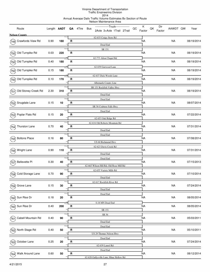
Crawfords View Rd 180 NA NAR
62-635 Craigs Store Rd
Dead EndTo:
From:
0.90
Nelson County
08/19/2014749
Old Turnpike Rd 220 NA NAR
SR 151
62-773 Afton Chapel RdFrom:
To:
From:
0.03 08/19/2014750
Old Turnpike Rd 180 NA NAR
62-839 Garwood LaneFrom:
To:
0.40 08/19/2014750
Old Turnpike Rd 180 NA NAR
62-637 Dick Woods LaneFrom:
To:
0.15 08/19/2014750
Old Turnpike Rd 170 NA NAR
Albemarle County LineTo:
0.10 08/19/2014750
Old Stoney Creek Rd 310 NA NAR
SR 151 Rockfish Valley Hwy
Dead EndTo:
From:
2.30 08/19/2014751
Snugdale Lane 10 NA NAR
Dead End
SR 56 Crabtree Falls HwyTo:
From:
0.15 08/07/2014752
Poplar Flats Rd 20 NA NAR
Dead End
62-653 Oak Ridge RdTo:
From:
0.15 07/22/2014753
Thurston Lane 40 NA NAR
62-634 Old Roberts Mountain Rd
Dead EndTo:
From:
0.70 07/31/2014754
Boltons Place 80 NA NAR
Dead End
US 60 Richmond HwyTo:
From:
0.16 07/08/2014755
Wright Lane 110 NA NAR
62-623 Davis Creek Rd
Dead EndTo:
From:
0.90 07/31/2014756
Bellevette Pl 40 NA NAR
Dead End
62-665 Wilson Hill Rd; Old Rose Mill RdTo:
From:
0.30 07/15/2013757
Cold Storage Lane 90 NA NAR
62-655 Variety Mills Rd
Dead EndTo:
From:
0.70 07/10/2014758
Grove Lane 30 NA NAR
62-617 Rockfish River Rd
Dead EndTo:
From:
0.15 07/24/2014759
Sun Rise Dr 20 NA NAR
Dead End
0.18 MN Dead EndFrom:
To:
From:
0.18 08/05/2014760
Sun Rise Dr 200 NA NAR
SR 151To:
0.40 08/05/2014760
Cabell Mountain Rd 90 NA NAR
SR 56
Dead EndTo:
From:
0.40 05/03/2011761
North Stage Rd 50 NA NAR
Dead End
US 29 Thomas Nelson HwyTo:
From:
0.40 05/10/2011762
October Lane 20 NA NAR
Dead End
62-639 Laurel RdTo:
From:
0.25 07/24/2014763
Walk Around Lane 50 NA NAR
Dead End
62-628 Gullysville Lane; Rhue Hollow RdTo:
From:
0.60 08/12/2014764
274/21/2015
Virginia Department of TransportationTraffic Engineering Division
2014Annual Average Daily Traffic Volume Estimates By Section of Route
Nelson Maintenance Area
Route AADT1Trail 2Trail
4TireK
QA2Axle 3+Axle
QC QKBusLength---------------Truck---------------
FactorAAWDT QW Year
Dir
Factor
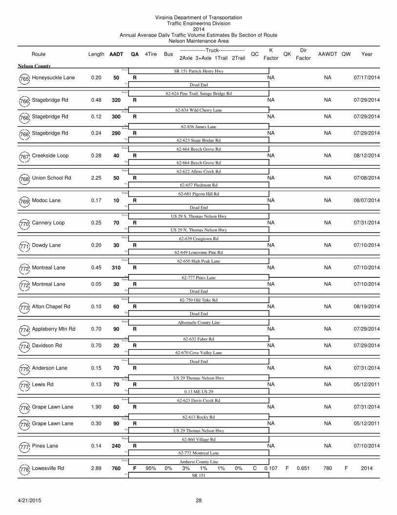
Honeysuckle Lane 50 NA NAR
SR 151 Patrick Henry Hwy
Dead EndTo:
From:
0.20
Nelson County
07/17/2014765
Stagebridge Rd 320 NA NAR
62-624 Pine Trail; Satage Bridge Rd
62-834 Wild Cherry LaneFrom:
To:
From:
0.48 07/29/2014766
Stagebridge Rd 300 NA NAR
62-836 James LaneFrom:
To:
0.12 07/29/2014766
Stagebridge Rd 290 NA NAR
62-623 Stage Bridge RdTo:
0.24 07/29/2014766
Creekside Loop 40 NA NAR
62-664 Beech Grove Rd
62-664 Beech Grove RdTo:
From:
0.28 08/12/2014767
Union School Rd 50 NA NAR
62-622 Allens Creek Rd
62-657 Piedmont RdTo:
From:
2.25 07/08/2014768
Modoc Lane 10 NA NAR
62-681 Pigeon Hill Rd
Dead EndTo:
From:
0.17 08/07/2014769
Cannery Loop 70 NA NAR
US 29 S, Thomas Nelson Hwy
US 29 N, Thomas Nelson HwyTo:
From:
0.25 07/31/2014770
Dowdy Lane 30 NA NAR
62-639 Craigtown Rd
62-649 Lonesome Pine RdTo:
From:
0.20 07/10/2014771
Montreal Lane 310 NA NAR
62-650 High Peak Lane
62-777 Pines LaneFrom:
To:
From:
0.45 07/10/2014772
Montreal Lane 30 NA NAR
Dead EndTo:
0.05 07/10/2014772
Afton Chapel Rd 60 NA NAR
62-750 Old Tpke Rd
Dead EndTo:
From:
0.10 08/19/2014773
Appleberry Mtn Rd 90 NA NAR
Albemarle County Line
62-632 Faber RdFrom:
To:
From:
0.70 07/29/2014774
Davidson Rd 20 NA NAR
62-670 Cove Valley LaneTo:
0.70 07/29/2014774
Anderson Lane 70 NA NAR
Dead End
US 29 Thomas Nelson HwyFrom:
To:
From:
0.15 07/31/2014775
Lewis Rd 70 NA NAR
0.13 ME US 29To:
0.13 05/12/2011775
Grape Lawn Lane 60 NA NAR
62-623 Davis Creek Rd
62-613 Rocky RdFrom:
To:
From:
1.90 07/31/2014776
Grape Lawn Lane 90 NA NAR
US 29 Thomas Nelson HwyTo:
0.30 05/12/2011776
Pines Lane 240 NA NAR
62-860 Village Rd
62-772 Montreal LaneTo:
From:
0.14 07/10/2014777
Lowesville Rd 760 0% 3% 0.107 780F F1% 1% C F
Amherst County Line
SR 151
95%To:
From:
2.89 0% 2014778 0.651
284/21/2015
Virginia Department of TransportationTraffic Engineering Division
2014Annual Average Daily Traffic Volume Estimates By Section of Route
Nelson Maintenance Area
Route AADT1Trail 2Trail
4TireK
QA2Axle 3+Axle
QC QKBusLength---------------Truck---------------
FactorAAWDT QW Year
Dir
Factor
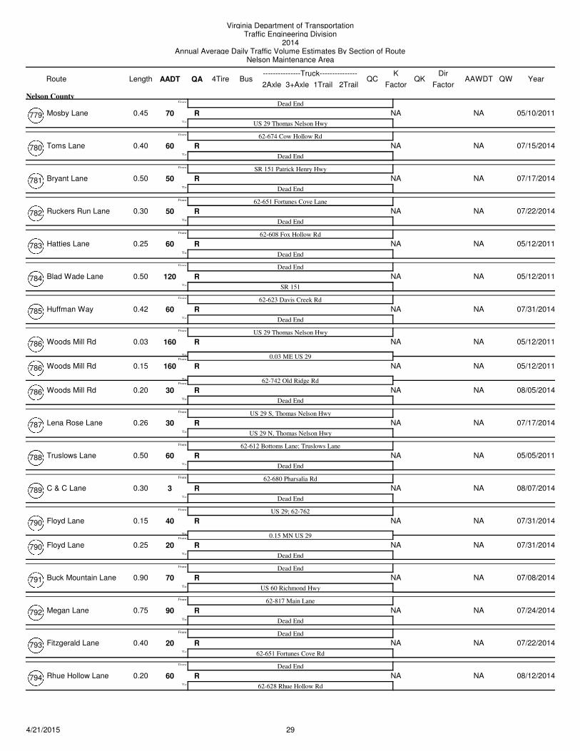
Mosby Lane 70 NA NAR
Dead End
US 29 Thomas Nelson HwyTo:
From:
0.45
Nelson County
05/10/2011779
Toms Lane 60 NA NAR
62-674 Cow Hollow Rd
Dead EndTo:
From:
0.40 07/15/2014780
Bryant Lane 50 NA NAR
SR 151 Patrick Henry Hwy
Dead EndTo:
From:
0.50 07/17/2014781
Ruckers Run Lane 50 NA NAR
62-651 Fortunes Cove Lane
Dead EndTo:
From:
0.30 07/22/2014782
Hatties Lane 60 NA NAR
62-608 Fox Hollow Rd
Dead EndTo:
From:
0.25 05/12/2011783
Blad Wade Lane 120 NA NAR
Dead End
SR 151To:
From:
0.50 05/12/2011784
Huffman Way 60 NA NAR
62-623 Davis Creek Rd
Dead EndTo:
From:
0.42 07/31/2014785
Woods Mill Rd 160 NA NAR
US 29 Thomas Nelson Hwy
0.03 ME US 29From:
To:
From:
0.03 05/12/2011786
Woods Mill Rd 160 NA NAR
62-742 Old Ridge RdFrom:
To:
0.15 05/12/2011786
Woods Mill Rd 30 NA NAR
Dead EndTo:
0.20 08/05/2014786
Lena Rose Lane 30 NA NAR
US 29 S, Thomas Nelson Hwy
US 29 N, Thomas Nelson HwyTo:
From:
0.26 07/17/2014787
Truslows Lane 60 NA NAR
62-612 Bottoms Lane; Truslows Lane
Dead EndTo:
From:
0.50 05/05/2011788
C & C Lane 3 NA NAR
62-680 Pharsalia Rd
Dead EndTo:
From:
0.30 08/07/2014789
Floyd Lane 40 NA NAR
US 29; 62-762
0.15 MN US 29From:
To:
From:
0.15 07/31/2014790
Floyd Lane 20 NA NAR
Dead EndTo:
0.25 07/31/2014790
Buck Mountain Lane 70 NA NAR
Dead End
US 60 Richmond HwyTo:
From:
0.90 07/08/2014791
Megan Lane 90 NA NAR
62-817 Main Lane
Dead EndTo:
From:
0.75 07/24/2014792
Fitzgerald Lane 20 NA NAR
Dead End
62-651 Fortunes Cove RdTo:
From:
0.40 07/22/2014793
Rhue Hollow Lane 60 NA NAR
Dead End
62-628 Rhue Hollow RdTo:
From:
0.20 08/12/2014794
294/21/2015
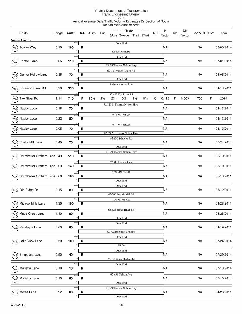
Virginia Department of TransportationTraffic Engineering Division
2014Annual Average Daily Traffic Volume Estimates By Section of Route
Nelson Maintenance Area
Route AADT1Trail 2Trail
4TireK
QA2Axle 3+Axle
QC QKBusLength---------------Truck---------------
FactorAAWDT QW Year
Dir
Factor
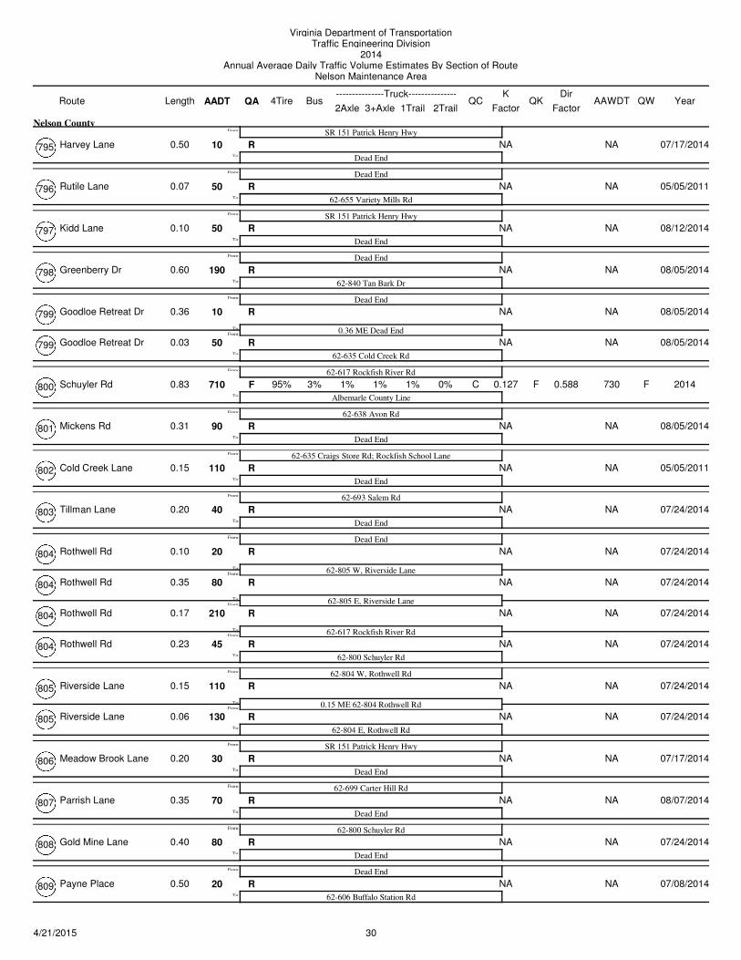
Harvey Lane 10 NA NAR
SR 151 Patrick Henry Hwy
Dead EndTo:
From:
0.50
Nelson County
07/17/2014795
Rutile Lane 50 NA NAR
Dead End
62-655 Variety Mills RdTo:
From:
0.07 05/05/2011796
Kidd Lane 50 NA NAR
SR 151 Patrick Henry Hwy
Dead EndTo:
From:
0.10 08/12/2014797
Greenberry Dr 190 NA NAR
Dead End
62-840 Tan Bark DrTo:
From:
0.60 08/05/2014798
Goodloe Retreat Dr 10 NA NAR
Dead End
0.36 ME Dead EndFrom:
To:
From:
0.36 08/05/2014799
Goodloe Retreat Dr 50 NA NAR
62-635 Cold Creek RdTo:
0.03 08/05/2014799
Schuyler Rd 710 3% 1% 0.127 730F F1% 1% C F
62-617 Rockfish River Rd
Albemarle County Line
95%To:
From:
0.83 0% 2014800 0.588
Mickens Rd 90 NA NAR
62-638 Avon Rd
Dead EndTo:
From:
0.31 08/05/2014801
Cold Creek Lane 110 NA NAR
62-635 Craigs Store Rd; Rockfish School Lane
Dead EndTo:
From:
0.15 05/05/2011802
Tillman Lane 40 NA NAR
62-693 Salem Rd
Dead EndTo:
From:
0.20 07/24/2014803
Rothwell Rd 20 NA NAR
Dead End
62-805 W, Riverside LaneFrom:
To:
From:
0.10 07/24/2014804
Rothwell Rd 80 NA NAR
62-805 E, Riverside LaneFrom:
To:
0.35 07/24/2014804
Rothwell Rd 210 NA NAR
62-617 Rockfish River RdFrom:
To:
0.17 07/24/2014804
Rothwell Rd 45 NA NAR
62-800 Schuyler RdTo:
0.23 07/24/2014804
Riverside Lane 110 NA NAR
62-804 W, Rothwell Rd
0.15 ME 62-804 Rothwell RdFrom:
To:
From:
0.15 07/24/2014805
Riverside Lane 130 NA NAR
62-804 E, Rothwell RdTo:
0.06 07/24/2014805
Meadow Brook Lane 30 NA NAR
SR 151 Patrick Henry Hwy
Dead EndTo:
From:
0.20 07/17/2014806
Parrish Lane 70 NA NAR
62-699 Carter Hill Rd
Dead EndTo:
From:
0.35 08/07/2014807
Gold Mine Lane 80 NA NAR
62-800 Schuyler Rd
Dead EndTo:
From:
0.40 07/24/2014808
Payne Place 20 NA NAR
Dead End
62-606 Buffalo Station RdTo:
From:
0.50 07/08/2014809
304/21/2015
Virginia Department of TransportationTraffic Engineering Division
2014Annual Average Daily Traffic Volume Estimates By Section of Route
Nelson Maintenance Area
Route AADT1Trail 2Trail
4TireK
QA2Axle 3+Axle
QC QKBusLength---------------Truck---------------
FactorAAWDT QW Year
Dir
Factor
Duncan Hollow Loop 60 NA NAR
SR 6 S, River Rd
62-619 Hill Hollow RdFrom:
To:
From:
0.40
Nelson County
05/05/2011810
Duncan Hollow Loop 40 NA NAR
SR 6 N, River RdTo:
0.90 07/31/2014810
League Lane 60 NA NAR
Dead End
62-741 Drumheller Orchard LaneTo:
From:
0.10 05/10/2011811
Lake Nelson Lane 380 NA NAR
62-655 Variety Mills Rd
0.80 MN 62-655From:
To:
From:
0.80 04/13/2011812
Lake Nelson Lane 210 NA NAR
Dead EndTo:
0.30 04/13/2011812
Whetstone Ridge 70 NA NAR
Blue Ridge Pkwy
62-603 Irish Creek RdTo:
From:
0.08 08/07/2014813
Campbells Mountain Rd 160 NA NAR
SR 56 Crabtree Falls Hwy
0.99 MN SR 56From:
To:
From:
0.99 05/05/2011814
Campbells Mountain Rd 110 NA NAR
62-684From:
To:
3.45 05/05/2011814
Campbells Mountain Rd 120 NA NAR
Blue Ridge PkwyFrom:
To:
0.03 08/07/2014814
230 1% 10% 0.12 240F F7% 1% C F
Augusta County Line, 07-814
81%To:
0.37 0% 2014814 0.793
Fishertown Lane 50 NA NAR
Dead End
SR 151 Patrick Henry HwyTo:
From:
0.40 07/15/2014815
Roberts Ridge Lane 110 NA NAR
62-613 Rodes Farm Rd
Dead EndTo:
From:
0.40 08/19/2014816
Mann Lane 20 NA NAR
Cul-de-Sac
0.46 MN Cul-de-SacFrom:
To:
From:
0.46 07/24/2014817
Mann Lane 80 NA NAR
62-792 Megan LaneFrom:
To:
0.04 07/24/2014817
Mann Lane 110 NA NAR
62-639 Craigtown RdTo:
0.25 04/19/2011817
Englande Rock Rd 20 NA NAR
62-631 Mountain Rd
Dead EndTo:
From:
0.20 08/05/2014818
Caskie Dr 100 NA NAR
62-656 Gladstone Rd
US 60 Richmond HwyTo:
From:
0.69 04/19/2011819
Twin Oaks Lane 20 NA NAR
Dead End
62-657 Tye River RdTo:
From:
0.40 07/08/2014820
Mountain View Lane 50 NA NAR
62-674 Rose Mill Rd
Dead EndTo:
From:
0.20 07/15/2014821
Seeman Lane 40 NA NAR
Dead End
62-690 Fish Hatchery LaneTo:
From:
0.40 08/07/2014822
314/21/2015
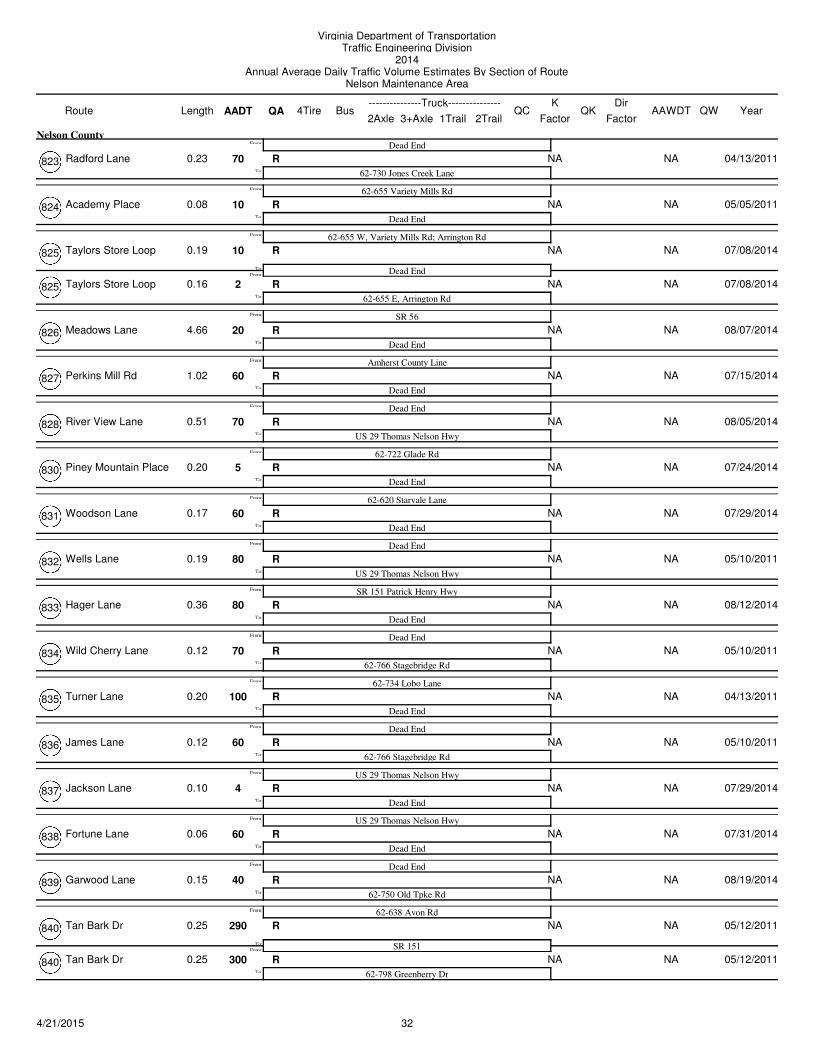
Virginia Department of TransportationTraffic Engineering Division
2014Annual Average Daily Traffic Volume Estimates By Section of Route
Nelson Maintenance Area
Route AADT1Trail 2Trail
4TireK
QA2Axle 3+Axle
QC QKBusLength---------------Truck---------------
FactorAAWDT QW Year
Dir
Factor
Radford Lane 70 NA NAR
Dead End
62-730 Jones Creek LaneTo:
From:
0.23
Nelson County
04/13/2011823
Academy Place 10 NA NAR
62-655 Variety Mills Rd
Dead EndTo:
From:
0.08 05/05/2011824
Taylors Store Loop 10 NA NAR
62-655 W, Variety Mills Rd; Arrington Rd
Dead EndFrom:
To:
From:
0.19 07/08/2014825
Taylors Store Loop 2 NA NAR
62-655 E, Arrington RdTo:
0.16 07/08/2014825
Meadows Lane 20 NA NAR
SR 56
Dead EndTo:
From:
4.66 08/07/2014826
Perkins Mill Rd 60 NA NAR
Amherst County Line
Dead EndTo:
From:
1.02 07/15/2014827
River View Lane 70 NA NAR
Dead End
US 29 Thomas Nelson HwyTo:
From:
0.51 08/05/2014828
Piney Mountain Place 5 NA NAR
62-722 Glade Rd
Dead EndTo:
From:
0.20 07/24/2014830
Woodson Lane 60 NA NAR
62-620 Starvale Lane
Dead EndTo:
From:
0.17 07/29/2014831
Wells Lane 80 NA NAR
Dead End
US 29 Thomas Nelson HwyTo:
From:
0.19 05/10/2011832
Hager Lane 80 NA NAR
SR 151 Patrick Henry Hwy
Dead EndTo:
From:
0.36 08/12/2014833
Wild Cherry Lane 70 NA NAR
Dead End
62-766 Stagebridge RdTo:
From:
0.12 05/10/2011834
Turner Lane 100 NA NAR
62-734 Lobo Lane
Dead EndTo:
From:
0.20 04/13/2011835
James Lane 60 NA NAR
Dead End
62-766 Stagebridge RdTo:
From:
0.12 05/10/2011836
Jackson Lane 4 NA NAR
US 29 Thomas Nelson Hwy
Dead EndTo:
From:
0.10 07/29/2014837
Fortune Lane 60 NA NAR
US 29 Thomas Nelson Hwy
Dead EndTo:
From:
0.06 07/31/2014838
Garwood Lane 40 NA NAR
Dead End
62-750 Old Tpke RdTo:
From:
0.15 08/19/2014839
Tan Bark Dr 290 NA NAR
62-638 Avon Rd
SR 151From:
To:
From:
0.25 05/12/2011840
Tan Bark Dr 300 NA NAR
62-798 Greenberry DrTo:
0.25 05/12/2011840
324/21/2015
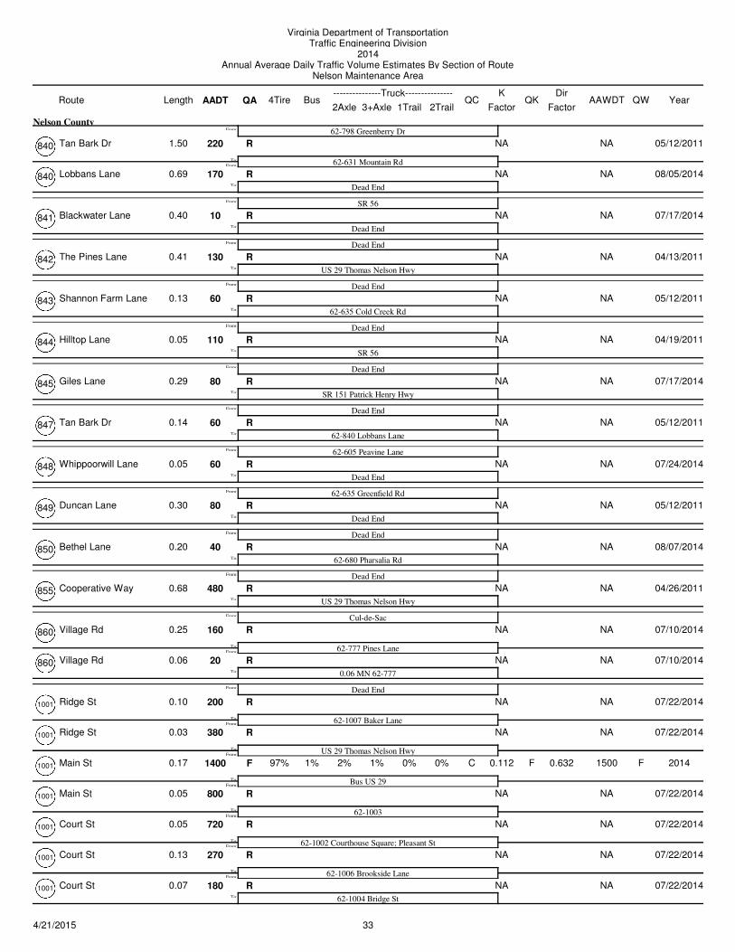
Virginia Department of TransportationTraffic Engineering Division
2014Annual Average Daily Traffic Volume Estimates By Section of Route
Nelson Maintenance Area
Route AADT1Trail 2Trail
4TireK
QA2Axle 3+Axle
QC QKBusLength---------------Truck---------------
FactorAAWDT QW Year
Dir
Factor
Tan Bark Dr 220 NA NAR
62-798 Greenberry Dr
62-631 Mountain RdFrom:
To:
From:
1.50
Nelson County
05/12/2011840
Lobbans Lane 170 NA NAR
Dead EndTo:
0.69 08/05/2014840
Blackwater Lane 10 NA NAR
SR 56
Dead EndTo:
From:
0.40 07/17/2014841
The Pines Lane 130 NA NAR
Dead End
US 29 Thomas Nelson HwyTo:
From:
0.41 04/13/2011842
Shannon Farm Lane 60 NA NAR
Dead End
62-635 Cold Creek RdTo:
From:
0.13 05/12/2011843
Hilltop Lane 110 NA NAR
Dead End
SR 56To:
From:
0.05 04/19/2011844
Giles Lane 80 NA NAR
Dead End
SR 151 Patrick Henry HwyTo:
From:
0.29 07/17/2014845
Tan Bark Dr 60 NA NAR
Dead End
62-840 Lobbans LaneTo:
From:
0.14 05/12/2011847
Whippoorwill Lane 60 NA NAR
62-605 Peavine Lane
Dead EndTo:
From:
0.05 07/24/2014848
Duncan Lane 80 NA NAR
62-635 Greenfield Rd
Dead EndTo:
From:
0.30 05/12/2011849
Bethel Lane 40 NA NAR
Dead End
62-680 Pharsalia RdTo:
From:
0.20 08/07/2014850
Cooperative Way 480 NA NAR
Dead End
US 29 Thomas Nelson HwyTo:
From:
0.68 04/26/2011855
Village Rd 160 NA NAR
Cul-de-Sac
62-777 Pines LaneFrom:
To:
From:
0.25 07/10/2014860
Village Rd 20 NA NAR
0.06 MN 62-777To:
0.06 07/10/2014860
Ridge St 200 NA NAR
Dead End
62-1007 Baker LaneFrom:
To:
From:
0.10 07/22/20141001
Ridge St 380 NA NAR
US 29 Thomas Nelson HwyFrom:
To:
0.03 07/22/20141001
Main St 1400 1% 2% 0.112 1500F F1% 0% C F
Bus US 29
97%
From:
To:
0.17 0% 20141001 0.632
Main St 800 NA NAR
62-1003From:
To:
0.05 07/22/20141001
Court St 720 NA NAR
62-1002 Courthouse Square; Pleasant StFrom:
To:
0.05 07/22/20141001
Court St 270 NA NAR
62-1006 Brookside LaneFrom:
To:
0.13 07/22/20141001
Court St 180 NA NAR
62-1004 Bridge StTo:
0.07 07/22/20141001
334/21/2015
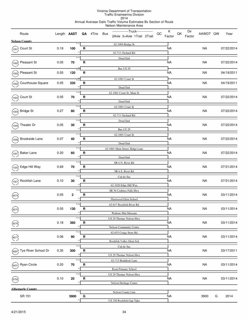
Virginia Department of TransportationTraffic Engineering Division
2014Annual Average Daily Traffic Volume Estimates By Section of Route
Nelson Maintenance Area
Route AADT1Trail 2Trail
4TireK
QA2Axle 3+Axle
QC QKBusLength---------------Truck---------------
FactorAAWDT QW Year
Dir
Factor
Court St 100 NA NAR
62-1004 Bridge St
62-711 Orchard RdTo:
From:
0.19
Nelson County
07/22/20141001
Pleasant St 70 NA NAR
Dead End
Bus US 29From:
To:
From:
0.05 07/22/20141002
Pleasant St 120 NA NAR
62-1001 Court StFrom:
To:
0.05 04/19/20111002
Courthouse Square 320 NA NAR
Dead EndTo:
0.05 04/19/20111002
Court St 70 NA NAR
62-1001 Court St; Main St
Dead EndTo:
From:
0.05 07/22/20141003
Bridge St 80 NA NAR
62-1001 Court St
62-711 Orchard RdTo:
From:
0.27 07/22/20141004
Theater Dr 30 NA NAR
Dead End
Bus US 29To:
From:
0.05 07/22/20141005
Brookside Lane 40 NA NAR
62-1001 Court St
Dead EndTo:
From:
0.07 07/22/20141006
Baker Lane 60 NA NAR
62-1001 Main Street; Ridge Lane
Dead EndTo:
From:
0.20 07/22/20141007
Edge Hill Way 70 NA NAR
SR 6 N, River Rd
SR 6 S, River RdTo:
From:
0.69 07/31/20141020
Rockfish Lane 30 NA NAR
Cul-de-Sac
62-1020 Edge Hill WayTo:
From:
0.10 07/31/20141021
2 NA NAR
SR 56 Crabtree Falls Hwy
Fleetwood Elem SchoolTo:
From:
0.05 03/11/20149274
130 NA NAR
62-617 Rockfish River Rd
Waltons Mtn MuseumTo:
From:
0.05 03/11/20149275
360 NA NAR
US 29 Thomas Nelson Hwy
Nelson Community CenterTo:
From:
0.18 03/11/20149276
90 NA NAR
62-635 Craigs Store Rd
Rockfish Valley Elem SchTo:
From:
0.06 03/11/20149277
Tye River School Dr 300 NA NAR
Cul-de-Sac
US 29 Thomas Nelson HwyTo:
From:
0.35 03/17/20119287
Ryan Circle 70 NA NAR
62-713 Braddock Lane
Ryan Primany SchoolTo:
From:
0.20 03/11/20149431
20 NA NAR
US 29 Thomas Nelson Hwy
Nelson Heritage CenterTo:
From:
0.10 03/11/20149755
SR 151 3900 NA 3900G G
Nelson County Line
US 250 Rockfish Gap TpkeTo:
From:
Albemarle County
2014
344/21/2015
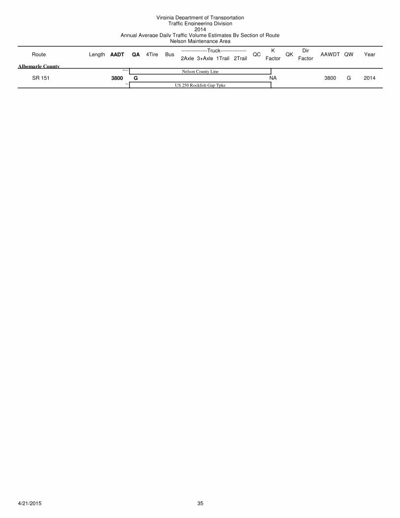
Virginia Department of TransportationTraffic Engineering Division
2014Annual Average Daily Traffic Volume Estimates By Section of Route
Nelson Maintenance Area
Route AADT1Trail 2Trail
4TireK
QA2Axle 3+Axle
QC QKBusLength---------------Truck---------------
FactorAAWDT QW Year
Dir
Factor
SR 151 3800 NA 3800G G
Nelson County Line
US 250 Rockfish Gap TpkeTo:
From:
Albemarle County
2014
354/21/2015