Embed Size (px)
Citation preview

Juvenile Crime in San Francisco, 1993-99: Trends and Challenges February 1, 2001
Prepared for: Delancy Street Foundation
James Tharp Robert Bennett Clarisse Choy Resource Development Associates
Juvenile Crime in San Francisco, 1993-99: A geographic and statistical analysis
Resource Development Associates January 2001 2
Juvenile Crime in San Francisco, 1993-99: A geographic and statistical analysis
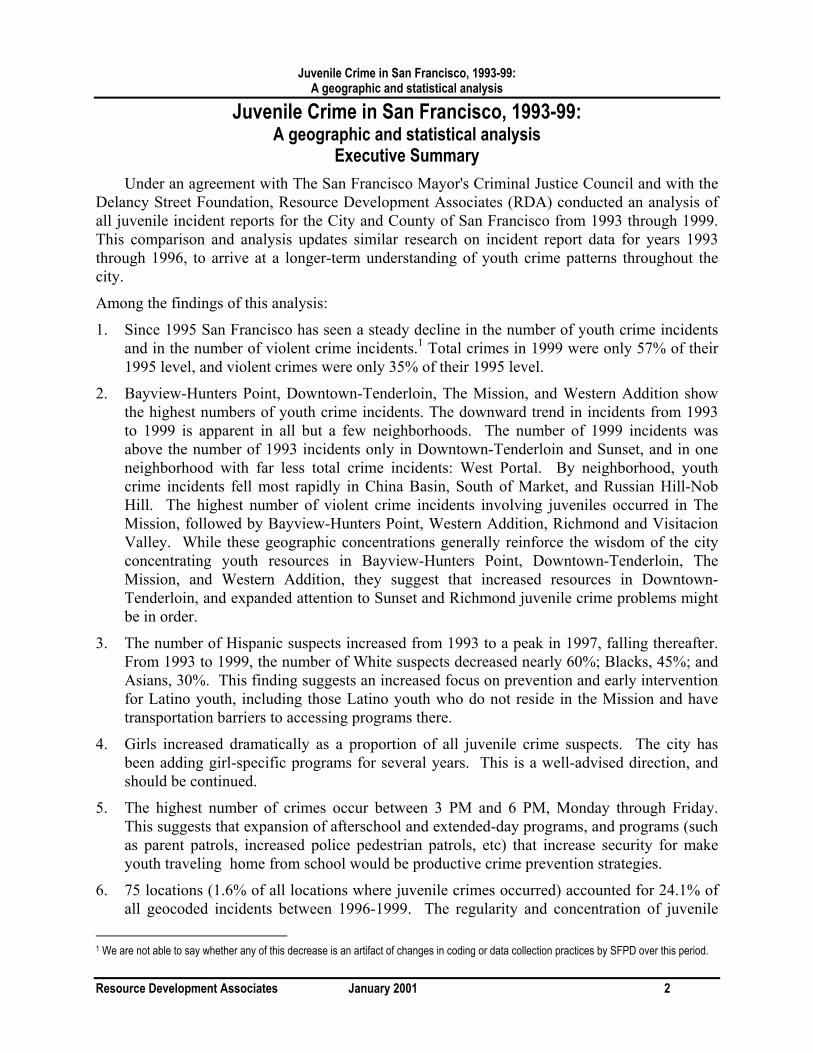
Executive Summary Under an agreement with The San Francisco Mayor's Criminal Justice Council and with the
Delancy Street Foundation, Resource Development Associates (RDA) conducted an analysis of all juvenile incident reports for the City and County of San Francisco from 1993 through 1999. This comparison and analysis updates similar research on incident report data for years 1993 through 1996, to arrive at a longer-term understanding of youth crime patterns throughout the city.
Among the findings of this analysis:
1. Since 1995 San Francisco has seen a steady decline in the number of youth crime incidents and in the number of violent crime incidents.1 Total crimes in 1999 were only 57% of their 1995 level, and violent crimes were only 35% of their 1995 level.
2. Bayview-Hunters Point, Downtown-Tenderloin, The Mission, and Western Addition show the highest numbers of youth crime incidents. The downward trend in incidents from 1993 to 1999 is apparent in all but a few neighborhoods. The number of 1999 incidents was above the number of 1993 incidents only in Downtown-Tenderloin and Sunset, and in one neighborhood with far less total crime incidents: West Portal. By neighborhood, youth crime incidents fell most rapidly in China Basin, South of Market, and Russian Hill-Nob Hill. The highest number of violent crime incidents involving juveniles occurred in The Mission, followed by Bayview-Hunters Point, Western Addition, Richmond and Visitacion Valley. While these geographic concentrations generally reinforce the wisdom of the city concentrating youth resources in Bayview-Hunters Point, Downtown-Tenderloin, The Mission, and Western Addition, they suggest that increased resources in Downtown-Tenderloin, and expanded attention to Sunset and Richmond juvenile crime problems might be in order.
3. The number of Hispanic suspects increased from 1993 to a peak in 1997, falling thereafter. From 1993 to 1999, the number of White suspects decreased nearly 60%; Blacks, 45%; and Asians, 30%. This finding suggests an increased focus on prevention and early intervention for Latino youth, including those Latino youth who do not reside in the Mission and have transportation barriers to accessing programs there.
4. Girls increased dramatically as a proportion of all juvenile crime suspects. The city has been adding girl-specific programs for several years. This is a well-advised direction, and should be continued.
5. The highest number of crimes occur between 3 PM and 6 PM, Monday through Friday. This suggests that expansion of afterschool and extended-day programs, and programs (such as parent patrols, increased police pedestrian patrols, etc) that increase security for make youth traveling home from school would be productive crime prevention strategies.
6. 75 locations (1.6% of all locations where juvenile crimes occurred) accounted for 24.1% of all geocoded incidents between 1996-1999. The regularity and concentration of juvenile
1 We are not able to say whether any of this decrease is an artifact of changes in coding or data collection practices by SFPD over this period.
Juvenile Crime in San Francisco, 1993-99: A geographic and statistical analysis
Resource Development Associates January 2001 3
crime incidents at hotspots that persist over many years suggest that these locations represent particular points of opportunity at which combined police community cooperation would have a disproportionate benefit in reducing juvenile crime.

Juvenile Crime in San Francisco, 1993-99: A geographic and statistical analysis
Resource Development Associates January 2001 4
Juvenile Crime in San Francisco, 1993-99: A geographic and statistical analysis
I. Purpose. Under an agreement with The San Francisco Mayor's Criminal Justice Council and with the
Delancy Street Foundation, Resource Development Associates (RDA) conducted an analysis of all juvenile incident reports for the City and County of San Francisco from 1993 through 1999. This comparison and analysis updates similar research on incident report data for years 1993 through 1996, to arrive at a longer-term understanding of youth crime patterns throughout the city. The longer-term analysis would also provide Delancy Street Foundation with further insight into the locations and frequencies of juvenile crime participation, in particular, incidents occurring within the vicinity of Delancy Street Foundation sited programs.
II. Sources of Data. San Francisco Police Department data about youth crime incidents was provided to RDA by
Delancy Street Foundation. Upon receiving the data sets from Delancy Street Foundation, RDA geocoded (assigned latitude/longitude coordinates to) each record. Some records were unable to be geocoded, as they contained misspelled, inaccurate, vague (such as “Common Place”, “Out of Town”, or “Unknown”) or nonexistent locations that could not be matched to locations in the geographic database. Data sets had a geocode rate between 79% and 94%; a total of 70470 records (85.8% of the total 82101 SFPD juvenile crime incident records received) were successfully geocoded.
The total number of records and the geocode rate for each year's data set is shown in Table 1, below.
Table 1: San Francisco Juvenile Crime Incident Records, 1993-1999 Number of Records and Geocode Rate, by Data Set Year
Year (data set) Total Number of Records
Number of Records Geocoded
Percent of Records Geocoded
1993 13,559 11,574 85.4% 1994 13,504 11,323 83.9% 1995 13,633 10,825 79.4% 1996 12,903 10,412 80.7% 1997 11,020 10,162 92.2% 1998 9,715 9,120 93.9% 1999 7,767 7,054 90.1% Total 82,101 70,470 85.8%
The datasets provided by SFPD had differing criteria as to which classes of crime incidents were included. Included throughout the 1993-99 period were crimes involving a juvenile suspect.2 Consequently, to ensure consistency across years, all analyses are based upon this class of crimes. By including all crimes with youth suspects, we obtain a broader and more consistent
2 Juvenile suspects are predominantly youth under the age of eighteen. A few crimes with 18-year-old suspects are included because they were charged as juveniles. A few crimes by youth under 18 are excluded because they were charged as adults.
Juvenile Crime in San Francisco, 1993-99: A geographic and statistical analysis
Resource Development Associates January 2001 5
look at juvenile crime patterns than we would if we only included juvenile arrests (which is the more common practice). As shown below, there was a consistent increase over the analysis period in the proportion of crime incidents that resulted in arrest. This trend would introduce a systematic bias into analyses that used juvenile arrests as an indicator of juvenile crime.
III. Citywide Trends As Figure 1, below, indicates, since 1995 San Francisco has seen a steady decline in the
number of youth crime incidents and in the number of violent crime incidents.3 Total crimes in 1999 were only 57% of their 1995 level, and violent crimes were only 35% of their 1995 level.4
Figure 2 disaggregates violent crimes by major category. Every category of violent crime shows a significant decline between 1995 and 1999; robberies showed the biggest overall decrease in both absolute and proportional terms. In 1999, the number of robberies was less than one-quarter of the 1995 count.
IV. Geographic Distribution of Youth Crimes: Rates and Trends Map 1, "Crimes Involving Juveniles: 1999," shows each geocoded youth crime incident
record as a red star. Clustering of these map symbols highlights some of the areas where youth crime incidents were more frequent. However, where these symbols are exactly superimposed over each other, any pattern of crime concentration is obscured. To avoid this problem, and to illuminate comparisons and trends, the analysis that follows uses thematic maps to display youth crime incidents in relation to: land area, population, and previous years' crime incidents.
Map 2 displays youth crime incidents in relation to land area (in square miles). In 1999, the citywide average was 151 incidents per square mile. Census tracts where the incident rate ran higher than this average are shaded light and dark red; tracts below the citywide average are shaded light and dark yellow. Tracts with lower-than-average youth crime incidents include land areas taken up by industry and parklands; tracts with higher rates include some of the most densely populated neighborhoods.
Map 3 places youth crime incidents in the context of total population5; a similar shading scheme is used to indicate areas with crime rates noticeably higher or lower than the citywide average of 9.7 incidents per 1000 persons. In this view, industrial and parkland areas appear to have relatively high crime rates (because they have few inhabitants but some crime); several of the high population density areas (in Downtown, The Mission, Bayview, and Western Addition) have high youth crime rates according to this measurement.
3 We are not able to say whether any of this decrease is an artifact of changes in coding or data collection practices by SFPD over this period. 4 As discussed in Section __ below, a significantly higher percentage of incidents resulted in arrest in 1999 that 1995, so juvenile arrests show a less steep decline over this period. 5According to the 1990 U.S. Census.

Juvenile Crime in San Francisco, 1993-99: A geographic and statistical analysis
Resource Development Associates January 2001 6
Insert Figure 1 here

Juvenile Crime in San Francisco, 1993-99: A geographic and statistical analysis
Resource Development Associates January 2001 7
Insert Figure 2 here

Juvenile Crime in San Francisco, 1993-99: A geographic and statistical analysis
Resource Development Associates January 2001 8
Insert map 1 here

Juvenile Crime in San Francisco, 1993-99: A geographic and statistical analysis
Resource Development Associates January 2001 9
Insert map 2 here

Juvenile Crime in San Francisco, 1993-99: A geographic and statistical analysis
Resource Development Associates January 2001 10
Insert map 3 here
Juvenile Crime in San Francisco, 1993-99: A geographic and statistical analysis
Resource Development Associates January 2001 11
Maps 4 through 6 show the rate of juvenile crime incidents per 1,000 population ages 10-18, by Census Tract for each of the most recent years under analysis. 6 The highest incidence-per-population rates appear in the Bayview Hunters Point, Potrero Hill, China Basin, South of Market, Civic Center, and Downtown-Tenderloin areas.
V. Demographic Trends Figure 2 correlates suspect age with suspect race. For each racial group, suspect ages are
quite similar, with 15- and 16-year-olds being the most frequent suspects. For Asians, 14-year-olds are the next most frequent age group; for the other racial groups, 17-year-olds are a larger proportion of the suspects.
Year-to-year Demographic Trends. For year-to year comparisons, a uniform set of 66,239 incident records (80.6% of the original
82101 SFPD juvenile crime incident records) was selected for complete demographic and geographic data. This selection removes records with a variety of apparent data entry errors. The following selection criteria were used.
Age, sex, and ethnicity of suspect. 2510 records removed because the age of the suspect was under 10, 294 records removed because the suspect's sex was not recorded, 683 records with no race data were added to 20 records with "unknown" race.
An exact date and time of the incident were required.190 records removed.
By race, Figure 3 shows the number of Hispanic suspects increasing from 1993 to a peak in 1997. From 1993 to 1999, the number of White suspects decreased nearly 60%; Blacks, 45%; and Asians, 30%
By age, Figure 4 shows the number of 17-year-olds in 1997 and 1998 to be above the 1993 baseline. From 1993 to 1999, the number of 17-year-olds decreased by 16%; 16-year-olds, 36%;15-year-olds, 45%; 14-year-olds, 49%; 13- and 12-year-olds, 40%.
By sex (see Figure 5), the number of female suspects was above the 1993 baseline until 1999, at which point a decreases to 15% below the 1993 figure; the number of male suspects steadily decreased to 45% below the 1993 baseline. As a consequence, the share of juvenile crimes involving girls increased as a proportion of overall crimes.
6 Population statistics for persons ages 10-18 in San Francisco are from the 1990 U.S. Census "STF1" data set.

Juvenile Crime in San Francisco, 1993-99: A geographic and statistical analysis
Resource Development Associates January 2001 12
Insert Map 4 here
Juvenile Crime in San Francisco, 1993-99: A geographic and statistical analysis
Resource Development Associates January 2001 13
Insert Map 5 here

Juvenile Crime in San Francisco, 1993-99: A geographic and statistical analysis
Resource Development Associates January 2001 14
Insert map 6 here.

Juvenile Crime in San Francisco, 1993-99: A geographic and statistical analysis
Resource Development Associates January 2001 15
Insert Figure 3 here.

Juvenile Crime in San Francisco, 1993-99: A geographic and statistical analysis
Resource Development Associates January 2001 16
Insert Figure 4 here.

Juvenile Crime in San Francisco, 1993-99: A geographic and statistical analysis
Resource Development Associates January 2001 17
Insert Figure 5 here.
Juvenile Crime in San Francisco, 1993-99: A geographic and statistical analysis
Resource Development Associates January 2001 18
VI. Chronological Patterns A few general patterns in juvenile crime incidents during 1993-1999 will be familiar. Figure
3, correlating time-of-day with suspect age, shows a well-known 3pm-6pm period of highest juvenile crime. Suspects in incidents at this time of day are most frequently aged 15 and 16, as they are in the other daytime and early evening time blocks. However, from 9pm to 6am, suspects aged 16 and 17 predominate. (A low number of incidents with 18-year-old suspects throughout the data sets reflects that these suspects are treated by police as adults.)
By day-of-week (see Figure 6), youth crime is consistently lower on Saturday and Sunday.
By time-of-day (aggregated to 3-hour timeblocks), the Monday through Friday tally (see Figure 7) shows greater concentration around the 3pm-6pm period than does the Saturday-Sunday tally. The rate of youth crime decreases for Monday-Friday time blocks were greatest between 6pm and 3am (over 40%), and nearly as great between noon and 6pm. For Saturday-Sunday time blocks, 6pm-3am crimes were down by more than 50%, with daytime incidents down by approximately 40%. (see Figure 8.)
VII. Suspect Outcomes Each crime incident record also includes information about each suspect’s outcome:
booked, cited, detained, admonished, exonerated, diverted, or no outcome. Each outcome is mutually exclusive; "no outcome" denotes that the suspect was either not apprehended, or was apprehended but there was insufficient evidence to warrant one of the other outcomes.
Table 2: Outcomes of Juvenile Crime Incidents by Year Year Number of Sus-
pects, age 10-18 Percent Booked
Percent Cited
Percent Detained
Percent Admonished
Percent Exonerated
Percent Diverted
Percent No Outcome
1993 10,860 21.5% 16.3% 11.3% 4.5% 0.1% 0.3% 45.9% 1994 10,691 21.5% 16.0% 12.6% 5.9% 0.1% 1.2% 42.7% 1995 10,209 20.2% 14.8% 12.0% 6.4% 0.1% 1.3% 45.2% 1996 9,860 22.1% 18.3% 13.4% 6.7% 0.1% 1.3% 38.0% 1997 9,456 26.4% 20.4% 15.9% 6.7% 0.1% 2.1% 28.6% 1998 8,544 26.0% 22.4% 14.7% 8.6% 0.0% 1.3% 27.0% 1999 6,619 26.8% 25.4% 14.4% 9.4% 0.1% 1.0% 22.9%
The overall decline in juvenile crime incidents is again apparent in this table. Also striking is that the percentage of suspects with "No Outcome" falls to half the 1993 rate. Corresponding increases in Bookings, Citations, Detentions and Admonitions can be seen. The rate of diversions rose from 1993 through 1997, and declined thereafter. One implication of this is that the juvenile arrest rate will show a less dramatic decrease over the 1995-99 than does the juvenile crime incident rate.
Suspect Outcomes in Violent and Non-Violent Incidents. (See Figures 9 and 10.)
Although "No Outcome" decreases steadily over the 1993-1999 study period, suspects in violent crimes have consistently been more than twice as likely to receive "no outcome" than those involved in non-violent crimes. (In 1999, 42.9% of suspects in violent incidents received "no outcome," compared with 16.4% of suspects in non-violent incidents.)

Juvenile Crime in San Francisco, 1993-99: A geographic and statistical analysis
Resource Development Associates January 2001 19
Insert figure 6 here

Juvenile Crime in San Francisco, 1993-99: A geographic and statistical analysis
Resource Development Associates January 2001 20
Insert figure 7 here
Juvenile Crime in San Francisco, 1993-99: A geographic and statistical analysis
Resource Development Associates January 2001 21
Insert figure 8 here

Juvenile Crime in San Francisco, 1993-99: A geographic and statistical analysis
Resource Development Associates January 2001 22
Insert figure 9 here

Juvenile Crime in San Francisco, 1993-99: A geographic and statistical analysis
Resource Development Associates January 2001 23
Insert figure 10 here
Juvenile Crime in San Francisco, 1993-99: A geographic and statistical analysis
Resource Development Associates January 2001 24
A steady increase in bookings for violent incidents put this rate (26.4% in 1999) very near the steady rate for non-violent incidents (26.9% in 1999).
Citations continued to be issued far less frequently in violent incidents (11.1% in 1999) than in non-violent incidents (30.1% in 1999).
Detentions and admonitions for violent incidents increased at a faster rate than they did for non-violent incidents; in 1999, detentions resulted from 10.0% of violent incidents (compared with 15.8% of non-violent incidents), and admonitions for both violent and non-violent incidents were about 9.4%.
Suspect Outcomes in Assault Incidents and battery Incidents. (See Figures 11 and 12.)
For both assaults and batteries, the high rate of "no outcome" (over 60% in 1993) is similar to the overall pattern for incidents classified as violent. By 1999, this rate has dropped to 45.9% for assaults, and to 35.8% for batteries.
Booking rates for both assaults and batteries doubled during the period, bringing the rate to 34.5% for assaults, and to 14.7% for batteries.
For assaults, the rate of detentions rose, and continued to outnumber citations (17.9% to 6.9% in 1999). For batteries, the opposite pattern prevailed: it was citations that rose to 17.9%, while detentions actually declined by one percentage point, to 5.0% in 1999.
For both assaults and batteries, the admonition rate quadrupled (to 4.3% for assaults, and to 16.0% for batteries, in 1999).
VIII. Neighborhood Distribution of Youth Crime Incidents Figure 13, "Juvenile Crimes by Neighborhood, 1993-1999" shows a count of incident
records in each annual data set, for each of 36 San Francisco neighborhood planning areas. Overall, youth-related crime incidents are decreasing. Bayview-Hunters Point, Downtown-Tenderloin, The Mission, and Western Addition show the highest numbers of youth crime incident records. For the latter two neighborhoods the decrease in youth crime incidents is rather steady; the former two areas show peak numbers of incidents in 1997 and 1998 before resuming the trend of declining incidents.
Figure 14 expresses these same numbers with respect to neighborhood size. When the number of youth crime incidents in each neighborhood is divided by the neighborhood's areas (in square miles), Downtown-Tenderloin and Japantown emerge as the areas of highest incident density, followed by The Mission and Western Addition.

Juvenile Crime in San Francisco, 1993-99: A geographic and statistical analysis
Resource Development Associates January 2001 25
Insert Figure 13 here

Juvenile Crime in San Francisco, 1993-99: A geographic and statistical analysis
Resource Development Associates January 2001 26
Insert Figure 14 here
Juvenile Crime in San Francisco, 1993-99: A geographic and statistical analysis
Resource Development Associates January 2001 27
IX. Neighborhood Trends in Youth Crime Incidents The raw numbers underlying Figures 13 and 14 are displayed in Table 3. Neighborhoods
are ordered according to the total number of youth crime incident records during the entire 1993 - 1999 study period. The downward trend in incidents from 1993 to 1999 is apparent in all but a few neighborhoods. The number of 1999 incidents was above the number of 1993 incidents only in Downtown-Tenderloin and Sunset, and in one neighborhood with far less total crime incidents: West Portal. For several neighborhoods, youth crime incidents peaked at some time between 1993 and 1999: Downtown-Tenderloin (1997-98), Parkside-Lakeshore (1996-97), North Beach (1994-96), Noe Valley (1994-95), Marina (1997-98), Civic Center (1997).
Table 4 expresses neighborhoods' annual crime incident record count as a ratio to the 1993 incident record count, so that neighborhood trends can more easily be identified. This "year-to-base-year" ratio shows again that overall, crime incidents decreased with each year, with the greater decreases occurring in the second half of the study period. For the entire city, the ratio of 1999 incidents to1993 incidents is 0.61 (i.e., the number of 1999 incidents was 61% of the number of 1993 incidents). By neighborhood, youth crime incidents fell most rapidly in China Basin, South of Market, and Russian Hill-Nob Hill.
Map 7, "S.F. Juvenile Crime Incidents, 1993 - 1999: Percent Net Change by Neighborhood," shows how incidents in individual neighborhoods deviated from the citywide average decline in youth crime incidents (a citywide average decline of 39%). Neighborhoods where incidents decreased by less than 23% or where incidents actually increased are shaded red to show a net change in youth crime incidents "over 40% above the citywide average."
A closer look at neighborhood trends is afforded by examining youth crime incidents in two separate time periods of equal duration. From 1993 to 1996, youth crime incidents decreased at a citywide average rate of 10%. From 1996 to 1999, the citywide average rate of decrease was 32%. Maps 8 and 9 show how neighborhood trends compared to these averages.
From 1993 to 1996, youth crime incidents actually increased in ten neighborhoods, the greatest rates of increase being seen in Ingleside Terrace, North Beach, and West Portal. Incidents declined at the greatest rate in China Basin, Japantown, and Glen Park; these areas are shaded green on Map 8, "1993 - 1996 Percent Net Change by Neighborhood," as are 3 more neighborhoods where incidents declined by at least 30% (i.e., at least 20 percentage points below the citywide average decline of 10%).
For 1996 through 1999, incidents increased only in Outer Mission, Civic Center, West Portal, and Downtown-Tenderloin. Incidents declined at the greatest rate in North Beach, South of Market, and South Beach-Rincon Hill.

Juvenile Crime in San Francisco, 1993-99: A geographic and statistical analysis
Resource Development Associates January 2001 28
Insert Table 3 here

Juvenile Crime in San Francisco, 1993-99: A geographic and statistical analysis
Resource Development Associates January 2001 29
Insert Table 4 here

Juvenile Crime in San Francisco, 1993-99: A geographic and statistical analysis
Resource Development Associates January 2001 30
Insert Map 7 here

Juvenile Crime in San Francisco, 1993-99: A geographic and statistical analysis
Resource Development Associates January 2001 31
Insert Map 8 here

Juvenile Crime in San Francisco, 1993-99: A geographic and statistical analysis
Resource Development Associates January 2001 32
Insert map 9 here
Juvenile Crime in San Francisco, 1993-99: A geographic and statistical analysis
Resource Development Associates January 2001 33
X. Neighborhood Trends in Violent Youth Crime Incidents Table 5 provides a count of violent youth-related crime incidents by San Francisco
neighborhood by year. “Violent crime” is defined as having an SFPD incident code of 01000 to 04164 or 26029 to 26036; these codes include classifications such as homicide, manslaughter, rape, robbery (with a weapon or bodily force), assault, and arson. The highest number of violent crime incidents involving juveniles occurred in The Mission, followed by Bayview-Hunters Point, Western Addition, Richmond and Visitacion Valley. The number of 1999 violent incidents was above the number of 1993 violent incidents only in the Sunset.
Table 6 expresses neighborhoods' annual violent crime incident record count as a ratio to the 1993 incident record count. This "year-to-base-year" ratio shows that for the entire city, the ratio of 1999 violent incidents to1993 violent incidents is 0.43 (e.g., the number of 1999 violent incidents were 43% of the number of 1993 violent incidents). This 57% decline is steeper than the 39% decline for youth crime incidents in general. By neighborhood, violent youth crime incidents fell most rapidly in China Basin, Glen Park, and Russian Hill-Nob Hill.
Map 10 categorizes neighborhood deviations from the overall trend in violent youth crime incidents, and can be compared to neighborhood trends in youth crime incidents in general (above, in Map 7). In the Sunset, for example, the net change rates for both violent incidents and incidents in general were above (i.e., worse than) the citywide averages. In South of Market, violent youth crime was up compared to the citywide average, while youth crime in general was down compared to the citywide average. Violent youth crime in Bayview-Hunters Point, Outer Mission, and Parkside-Lakeshore was moderately above the citywide average, but youth crime overall was up by a greater degree in these areas.
Examining this array of figures for the two separate time periods, we see that from 1993 to 1996, violent incidents decreased at a citywide average rate of 15% (compared to the 10% decline for youth crime in general, noted above). In ten neighborhoods, violent youth crime incidents increased during this period. From 1996 to 1999, violent incidents decreased by 50% (compared to the 32% decrease for youth crime in general).
Maps 11 and 12 show how neighborhood trends compared to these averages. From 1993 to 1996, violent incidents increased the most in South Beach-Rincon Hill, North Beach, and Ingleside Terrace. Violent incidents declined at the greatest rate in China Basin and Diamond Heights. For 1996 through 1999, violent incidents held steady in increased only in Outer Mission, Civic Center, West Portal, and Downtown-Tenderloin. Incidents declined at the greatest rate in North Beach, South of Market, and South Beach-Rincon Hill.
Juvenile Crime in San Francisco, 1993-99: A geographic and statistical analysis
Resource Development Associates January 2001 34
Insert table 5 here

Juvenile Crime in San Francisco, 1993-99: A geographic and statistical analysis
Resource Development Associates January 2001 35
Insert table 6 here
Juvenile Crime in San Francisco, 1993-99: A geographic and statistical analysis
Resource Development Associates January 2001 36
Insert map 10 here
Juvenile Crime in San Francisco, 1993-99: A geographic and statistical analysis
Resource Development Associates January 2001 37
Insert map 11 here

Juvenile Crime in San Francisco, 1993-99: A geographic and statistical analysis
Resource Development Associates January 2001 38
Insert map 12 here
Juvenile Crime in San Francisco, 1993-99: A geographic and statistical analysis
Resource Development Associates January 2001 39
XI. Persistent Youth Crime Hotspots in San Francisco, 1996-1999. Of the 41,274 SFPD youth crime incident records for events occurring between 1996 and
1999, 36,648 records (88.8%) had location information sufficient for geocoding to a precise latitude/longitude location. For a "hotspot" analysis, location aggregation was accomplished by rounding latitude and longitude to the thousandth of a degree (approx. 100 yards). This technique made possible a comparison to the 1993 -1996 incident data, which had been geocoded using an earlier edition of the base map of San Francisco streets.
The 1996 through 1999 youth crime incidents therefore took place at 4,671 aggregate locations (or "spots"). A "persistent hotspot" was defined as a spot where 6 or more youth crime incidents occurred in each of four consecutive years. Concentrations of persistent hotpots are in the Downtown-Tenderloin area, along Mission Street and along Haight Street. (See Map 13.)
75 locations (1.6% of all locations where crimes occurred) were found to be hotspots; 8,841 incidents (24.1% of all geocoded incidents) occurred at these hotspots.
The top ten hotspots (0.2% of all locations where crimes occurred) accounted for 8.9% (3,270) of all incidents.
A similar analysis for youth crime incidents between 1993 and 1996 showed 129 persistent youth crime hotpots, where 12,657 incidents (28.7%) occurred. (See Map 14.)
58 of the 1996-1999 hotspots (77.3%) had been hotspots in the 1993-1996 period.
Of the top ten hotspots for 1996-1999, seven had been among the top ten in the 1993-1996 period.
The regularity and concentration of juvenile crime incidents at hotspots that persist over many years suggest that these locations represent particular points of opportunity at which com-bined police community cooperation would have a disproportionate benefit in reducing juvenile crime. Table 7 below, lists the Top 10 hotspots for 1996-1999.

Juvenile Crime in San Francisco, 1993-99: A geographic and statistical analysis
Resource Development Associates January 2001 40
Insert map 13 here
Juvenile Crime in San Francisco, 1993-99: A geographic and statistical analysis
Resource Development Associates January 2001 41
Insert map 14 here

Juvenile Crime in San Francisco, 1993-99: A geographic and statistical analysis
Resource Development Associates January 2001 42
Table 9 Top 20 Youth Crime Hotspots, 1996-1999 Youth crime count by Year 1996 1997 1998 1999
Rank in 1993-1996
Location
222 209 98 97 1 Winston Drive between 19th and 20th Avenues (Stonestown Galleria)
46 218 210 106 2 5th and Market Streets (Powell Street BART)
114 65 125 93 4 Geary Blvd at Masonic Avenue
74 63 111 75 7 Portola Drive at Twin Peaks Blvd. (McAteer High School)
57 74 113 31 6 Bay and Francisco Streets between Van Ness Avenue and Polk Street (Galileo High School)
61 87 42 58 12 Stockton Street, between O'Farrell and Market
72 58 51 64 9 14th Avenue at Santiago (Hoover Middle School)
42 34 81 72 11 Onondaga and Cayuga Ave. (Balboa High)
50 73 59 46 19 O'Farrell Street between Stockton and Powell Streets
35 65 65 47 8 Potrero Avenue at 22nd Street (SF General)
36 39 81 50 18 16th and Mission Streets
66 35 47 56 13 Brazil and LaGrande Avenues (Burbank Jr. High)
35 84 41 30 22 Eddy and Leavenworth Streets
9 69 49 49 16 Portola Drive at Woodside Avenue (Youth Guidance Center)
59 38 29 40 17 Church Street at Chula Lane (Mission High)
35 41 52 27 15 Ortega Street between 38th and 39th Avenues (Giannini Middle School)
17 17 26 90 24 Market Street between Powell and Stockton (between 4th and 5th Streets)
23 31 44 48 28 24th Avenue between Quintara and Rivera Streets (Lincoln High School)
34 34 53 22 21 18th and DeHaro St. (Potrero Hill Middle School)
43 40 20 32 10 4th and Market Streets

Juvenile Crime in San Francisco, 1993-99: A geographic and statistical analysis
Resource Development Associates January 2001 43
Attachment 1: Multiple Suspect Crime Incidents Incident Records Represent Suspects. Each youth crime incident record contains data about the date, time, location, and type of a crime incident, together with demographic data about a single suspect in that incident. For incidents with multiple suspects, therefore, the data set contains multiple incident records. (Note: Demographic data about suspects or witnesses to these incidents was not available.) Because this report is very much interested in the demographics of youth crime, we will be analyzing data about all suspects in these data sets. At the risk of some confusion, this report refers to numbers, ratios, and percentages of "youth crime incidents," although we will consistently be counting the number of "suspects in youth crime incidents."
An actual youth crime incident may be identified by a unique combination of date, time and location. The table below shows the degree to which youth crime incidents were multiple-suspect incidents. During the 1993-1999 study period, the percentage of multiple-suspect incidents has declined modestly, albeit steadily, from 21.0% of incidents in 1993 and 1994 to 18.2% in 1999.
San Francisco Juvenile Crime Incidents, 1993-1999 Multiple-Suspect Incidents, by Number of Suspects by Year
Number of Suspects
1993 1994 1995 1996 1997 1998 1999
2 12.6% 12.6% 11.8% 12.3% 11.5% 13.0% 11.5% 3 4.8% 4.7% 5.2% 4.6% 4.0% 3.4% 3.7% 4 1.8% 2.1% 2.1% 1.7% 1.8% 1.7% 1.7% 5 0.9% 0.8% 0.9% 0.8% 0.8% 0.8% 0.5% 6 0.4% 0.3% 0.4% 0.3% 0.3% 0.3% 0.3% 7 0.2% 0.2% 0.2% 0.2% 0.1% 0.2% 0.1% 8 0.1% 0.1% 0.1% 0.1% 0.2% 0.1% 0.1% 9 0.0% 0.0% 0.1% 0.1% 0.1% 0.1% 0.1% 10 and over 0.1% 0.1% 0.1% 0.1% 0.1% 0.0% 0.1% Total Multiple-Suspect Incidents
21.0%
21.0%
20.8%
20.1%
18.8%
19.5%
18.2%