Embed Size (px)
Citation preview

KALAPPAIPATTI LIMESTONE MINE
(PUBLIC SECTOR /’B’ CATEGORY / MANUAL / ROM & PMCP /
PATTA LAND / NON-CAPTIVE USE)
(Submitted under Rule 17 (1) of MCR 2016 & Rule 23 of MCDR 2017)
Period of Review of Mining – 2016 -18 to 2021-22
G.O. Rc. No. 1712 / MM4 / 2010, Dated 27.04.2012
DATE OF EXPIRY OF LEASE : 08.07.2032
IBM Registration No : IBM / 14531 / 2012
Mine code : 38TMN31010
Extent : 4.70.0 Hectares
S.F.No. : 238
Village : Kalappaipatti
Taluk : Ottapidaram
District : Thoothukudi
State : Tamil Nadu
Shri. M.THANAPAL
No.1/2B, North Street,Bharathi Nagar
Kovilpatti, Pin – 628 501
Thoothukudi Dist, Tamilnadu
Cell No : 98421 59219 , 96599 95249
Shri. N.Ravinthiran, M.Sc.(App.Geo), Recognized Qualified Person
RQP/MAS/130/98/A
(Valid up to 20.12.2020) Cell No : 98421 26699
Email : [email protected] , [email protected]

TABLE OF CONTENTS
S.NO. DESCRIPTION PAGE
NO 1 Introduction 1
2 General 2
3 Location and Accessibility 3
4 Details of Approved Mining Plan / Scheme of Mining 6
Part – A
5 Geology and Exploration 9
6 Mining 26
7 Mine Drainage 36
8 Stacking of Mineral Reject / Sub grade Material &
Disposal of Waste 37
9 Use of Mineral and Mineral Reject 38
10 Processing of ROM and Mineral Reject 39
11 Other 40
12 Progressive Mine Closure Plan under rule 23 of
MCDR 1988 41
13 Part-B Certificates 59

ANNEXURES
Sl
No
List of Documents Annexure
No
1 Feasibility Report
I
2 Lease deed II
3 Copy of the Recognised Qualified Person III
4 Photographs of kalappaipattii Limestone working pit,
Boundary pillars and Afforestation & Dump
IV
5 Address proof and Id proof of the Lessee V
6 Copy of the approval of Scheme of Mining VI
7 Copy of the FMB, patta for the lease area VII
8 powder sample Tested in Analytical Report from the
Bombay Test House Pvt. Ltd in Salem accredited
laboratory
VIII
9 Undertaking by the Lessee IX
10 Bank Guarantee X
11 Soft Copy of Mining Plan in word form – CD
XI

LIST OF PLATES
Sl.No
Plate Nos Details Scale
1 PLATE-I Location Plan Not to scale
2 PLATE-IA Route Map Not to scale
3 PLATE-II
Key Plan 1:50000
4 PLATE-III
Mine Lease Plan 1:2000
5 PLATE-IV
Surface Plan 1:1000
6 PLATE-V
Geological Plan & Sections 1:1000
7 PLATE-VI
Year Wise Production &Development Plan & Sections
1:1000
8 PLATE-VII
Environmental Plan 1:5000
9 PLATE-VIII
Progressive Mine Closure Plan 1:1000
10 PLATE-IX
Conceptual Plan & Sections 1:1000
11 PLATE-X Financial Area Assurance Plan 1:1000

REVEIW OF MINING PLAN / SCHEME OF MINING AND PROGRESIVE MINE CLOSURE PLAN FOR
KALAPPAIPATTI LIMESTONE MINE.
(PUBLIC SECTOR/“B” CATEGORY / MANUAL/ROM & PMCP/PATTA LANDS/NON CAPTIVE USE/)
(Period of scheme 2017-18 TO 2021-22) Under Rule 17(1) of MCR 2016 and 23 of MCDR 2017)
Registration No. : IBM/14531/2012 MINE CODE : 38 TMN31010
0.1 Introduction:
The concise report deals with the scheme of mining and progressive mine closure plan
for Lime stone mineral over an extent of 4.70.0 Ha. In S.F.No : 238, in Kalappaipatti village,
Ottapidaram Taluk, Thoothukudi District, Tamilnadu State has been prepared for Shri. M.
Thanapal, S/o Shri. M. Muthusamy, 1/2B – North street, Bharathi Nagar, Kovilpatti – 628501.
The five years mining plan period expires on 31/03/2017. The modification of mining
plan is applied based on the condition given in the approved mining plan . the approved
mining plan have been modified for enhancements of proved reserves and decreased in
production program for next three years. The modified mining plan was approved by Indian
Bureau of Mines vide letter No. TN/TNK/MP/LST-1925.MDS, dated 04.08.2014 and next
scheme of mining submission due were given on 01.12.2016.
The applicant is having 15 years experience in manufacturing of mineral powder for
Soap, Paints, Wallputty, Hydrated lime and Detergent industries. The mineral to be raised
shall be used for non-captive purpose.
0.2 The mining plan for fresh grant of mining lease was approved by the Indian Bureau of
Mines vide letter No-TN/TKD/MP/LST-1802-MDS dated 09/04/2012 before grant of mining
lease. The mining lease for limestone was granted vide by State Government, Department of
geology and Mining , Government of Tamilnadu vide letter Rc.No.1712/MM4/2010 dated
27.04.2012. The mining lease was executed on 09/07/2012 and expires on 08/07/2032.
The five years mining plan period is expires on 31/03/2017. The modification of mining
plan is applied based on the condition given in the approved mining plan . the approved
mining plan have been modified for enhancements of proved reserves and decreased in
production program for next three years. The modified mining plan was approved by Indian
Bureau of Mines vide letter No. TN/TNK/MP/LST-1925.MDS, dated 04.08.2014 and next
scheme of mining submission due were given on 01.12.2016.

0.3 This present scheme of mining (2017-18 to 2021-22) along with PMCP is prepared
now for submission to Indian Bureau of Mines for approval under Rules 17(1) of MCR 2016
& 23 of amended MCDR, 2017.
0.4 Strategy of Mining Lease:
The mining lease for limestone was granted vide by State Government, Department of
geology and Mining , Government of Tamilnadu vide letter Rc.No.1712/MM4/2010 dated
27.04.2012. The mining lease was executed on 09/07/2012 and expires on 08/07/2032.
For environmental clearance SEIAA-TN has given clear notification to apply EC to MOEF &
CC at New Delhi as per NGT order. The lessee is processing EC to MOEF& CC.
1.0 General
a) Name of the applicant : Shri M. Thanapal,
Registration No. : IBM/14531/2012
Mine code : 38TMN31010
Address : 1/2B, North street, Bharathi Nagar,
Kovilpatti -628 501
THOOTHUKUDI - DISTRICT.
District : Thoothukudi
State : Tamil Nadu
Cell : 96599 -95429
E-mail : [email protected]
b)Status of the applicant / lessee
Private Individual : Private
Co operative Association : Nil
Private Company : Individual
Public limited Company : Nil
Public Sector Undertaking : Nil
Joint Sector Undertaking : Nil
Other (Please specify) : Nil
c) Mineral(s) which is / are included in the prospecting license:
It is an Existing Mine and the Mineral exploited is Limestone.
d) Mineral(s) which is / are included in the letter of Intent /lease deed:

The mining lease for limestone was granted vide by State Government, Department of
geology and Mining, Government of Tamilnadu vide letter Rc.No.1712/MM4/2010 dated
27.04.2012 over an extent of 4.70.0 Hectares in Survey Nos. 238 of Kalappaipatti Village in
Ottapidaram Taluk, Thoothukudi District.
e) Mineral(s) Which is the applicant / lessee intends to mine :
- Limestone -
f) Name of Recognised Person under rule 22C OF MCR,1960:
Name : Shri. N.Ravinthiran, M.Sc.(App.Geo),
Address : 1699/1, Madurai Road,
Opp. ABCOY Garden,Sankar Nagar (Post),
Tirunelveli - 627 357.
e.mail id : [email protected]
Mobile No : 9842126699
Registration No : RQP/MAS/130/98/A
Date of Grant / Renewal : 21.12.1998,
valid up to : 20.12.2020
2.0 Location & Accessibility:
a) Lease Details(Existing Mine):
Name of Mine (Existing Mine) :Kalappaipatti Limestone Mine
Lat /Long of any boundary point: Latitude: N08° 54’12”
Longitude: E77°48’10”
The mining lease for limestone was granted vide by State Government, Department of
geology and Mining, Government of Tamilnadu vide letter Rc.No.1712/MM4/2010 dated
27.04.2012.for a period of twenty years. Copy of lease deed is enclosed as Annexure II.
Date of grant of lease : 27-04-2012, for 20 years.
Date of expired : 08-07-2032
Date of mining operation : 02.10.2012
Name of leaseholder : Shri M. Thanapal,
Postal Address : 1/2B, North street, Bharathi Nagar,
Kovilpatti -628 501
Thoothukudi - District.

District : Thoothukudi
State : Tamil Nadu
Pin Code : 628 501
Mobile No : 9659995249, 9842159219
E-mail ID : [email protected]
b) Details of applied /lease area with location map (fresh area / mine):
The state Government have granted Mining Lease for total extent of 4.70.0 Ha in
survey No. 238 of Kalappaipatti village vide Rc.No.1712/MM4/2010 dated 27.04.2012 and
executed on 09-07-2012.
Table – 1
S.No Village Taluk District Type of Land Survey No Extent (Ha)
1 kalappaipatti Ottapidaram Thoothukudi Patta 238 4.70.0 Ha
It is a Non Forest area. The lease is on Patta lands.
Table – 2
(Please refer Key Plan and Lease Plan No. IB & II)
Total Lease area/applied area:4.70.0 Ha
District and State : Thoothukudi, Tamil Nadu
Taluk : Ottapidaram
Village : Kalappaipatti
Whether the area falls under Coastal Regulation Zone (CRZ) ?If, details thereof:
-- NO–
Existence of public road / railway line, if any nearby and approximate distance:
Road link:
Forest Non Forest
Forest (specify)
Area (ha)
Nil
(i) Waste land (ii) Grazing land (iii) Agriculture land (iv) others (specify)
Area (ha) Nil Nil Nil
Patta land .4.70.0 ha

This mining lease area is situated 25 km away from Kovilpatti. Tirunelveli-Madurai NH 7 is
passing through Rajapudukudi Village. The connecting mining lease area to NH 7 a metal
road from Rajapudukudi lies in the distance of 7 Km . Location Plan and Key Plan showing
the mining lease area are enclosed.
Rail link:
The nearest railway station is Tirunelveli at a distance of 20 km from the limestone mine.
Air port:
The nearest Airport is at Tuticorin at a distance of 35 km.
Topo sheet No.with latitude & longitude of all corner boundary point/ pillar.
Geographically the Mining lease is bounded by N 08° 54’12” latitude and
E77°48’10” longitude in Survey of India topo sheet No.58H/5, shown in the key plan at
Plate No: II This area is with an altitude of MSL 140m.
GPS Co- ordinate points of the latitude and longitudes
Table-3
LABEL LATITUDE LONGITUDE
A 8.902635 N 77.802952 E
B 8.903155 N 77.802985 E
C 8.903273 N 77.802662 E
D 8.905983 N 77.802816 E
E 8.905839 N 77.803937 E
F 8.904674 N 77.804040 E
G 8.903672 N 77.804444 E
H 8.903506 N 77.803978 E
I 8.903441 N 77.803993 E
J 8.903413 N 77.803794 E
K 8.902653 N 77.803805 E
- Refer Plate –III for Lease plan.
c) Attach a general location map showing area and access routes. It is preferred that
the area be marked on a survey of India topographical map or a cadastral map or
forest map as the case may be. However, if none of these are available, the area may
be shown on an administrative map.
Location Plan and Key Plan showing the mining lease area are enclosed.

3.0DETAILS OF APPROVED MINING PLAN /SCHEME OF MINING (if any):-
3.1 Date and reference of earlier approved MP/SOM:
The mining plan for fresh grant of mining lease was approved by the Indian Bureau of
Mines vide letter No-TN/TKD/MP/LST-1802-MDS dated 09/04/2012 before grant of mining
lease.
The modified mining plan was approved by Indian Bureau of Mines vide letter No.
TN/TNK/MP/LST-1925.MDS, dated 04.08.2014 and next scheme of mining submission due
was given on 01.12.2016( Refer : ANNEXURE - VI )..
This Scheme of Mining has been prepared and is being submitted under rule 17 (1)
OF MCR 2016 and 23 of MCDR 2017.
3.2 Details of last modifications if any (for previous approved period) of approved MP
/SOM, indicating date of approval, reason for modification
The five years mining plan period is expires on 31/03/2017. The modification of mining
plan is applied based on the condition given in the approved mining plan. The approved
mining plan have been modified for enhancements of proved reserves and decreased in
production program for next three years. The modified mining plan was approved by Indian
Bureau of Mines vide letter No. TN/TNK/MP/LST-1925.MDS, dated 04.08.2014
3.3 Give review of earlier approved proposal (if any) in respect of exploration,
excavation, reclamation etc.
Exploration:
In the previous mining plan there are five bore holes were proposed, but due to
financial crises of Mine owner , the only one wagon drill bore was drilled .
Table – 4
Year Month No. of Wagon drill holes
Total meterage
2014 – 2015 October 2014 1 no. Upto 11 m depth from pit level
The area is very small. The attitude of the limestone band like width and length are
clearly known. Depth persistence of limestone in this area was proved to be 11.0 m from
ground level.
Based on the existing working pit results, the strike and the dip are calculated.
Due to the lack of market demand, non – continuous workings and non – availability
of labour, lack of bulk orders from industries like manufacturing of mineral powder for Soap,
paints, detergent industries etc., the proposed and proved quantity was not mined in the

modified mining plan period. Hence the proved quantity of the approved mining plan will be
taken in the scheme of mining period of 2017 – 18 to 2021 – 22. In this scheme of period,5
No of Diamond drill hole was proposed in the non working area of the mineral band.
Locations of drilled borehole and proposed borehole are marked in the geological plan and
sections . (Refer Plate No. V).
Mine Development:
As it has been specified in the modified mining plan, development work is undertaken to win Limestone. At present, there are five existing pits and its dimensions are given below:
Table – 5
Pit holes Length (M) Width (M) Depth (M)
Pit no – I 26 22 11.0
Pit no – II 40 24 11.0
Pit no – III 66 26 2.0
Pit no – IV 82 36 6.0
Pit no – V 48 22 6.0
Handling of waste:
The topsoil generated during mining would be stored separately and it will be used for
plantation. The side burden and mineral rejects are dumped in the ear marked area.
Exploitation:
In the approved Modified Mining plan for the period (2014 -15 to 2017-18) a total production
quantity of 7,488 Tonnes of Limestone was planned.
The details of year wise planned production Actual production and deviation in production of
Limestone for the mining plan (2014-15 to 2017-18)are given below.
Table-6
Year
Proposal Actual
Rom
(Ts)
Limestone
80% (Ts)
Mineral Rejects
(Cum)
Rom
(Ts)
Limestone
(Ts)
Mineral Rejects
(Ts)
2012-13 - - - 825.00 660.00 165.00
2013-14 - - - 834.00 667.095 166.80
2014-15 3120 2496 624 995.05 796.040 199.01
2015-16 3120 2496 624 1202.687 962.150 240.537
2017-18 3120 2496 624 - - -
TOTAL 9360 7488 1872 3856.737 3085.285 771.347

Reclamation & Rehabilitation:
It is a working mine. So Reclamation and Rehabilitation are does not arise.
Afforestation Programme:
In the previous plan period it was proposed to plant 20 neem trees per year covering
an area of 100 sqm / year, with 80% survival rate all along the boundary barrier of the mining
lease area. The afforestation was carried out as proposed but only few trees (below 20%)
survived due to scanty rainfall. The lessee ensures to compensate this afforestation during
the present scheme period.
Table-7
Year
Name of
the
Species
No. of
saplings
Planned
Expected
Survival Rate
%
2017-18 Neem 20 80
2018-19 Neem 20 80
2019-20 Neem 20 80
2021-22 Neem 20 80
2021-22 Neem 20 80
3.4 Give status of compliance of violation pointed out by IBM
While MCDR inspection of the mine , the violation was given on 07-04-
2017 under rule 14 (4) & 28 (1)
3.5 Indicate and give details of any suspension /closure /propitiatory order issued by
any Government agency under any rule or Court of law.
Nil
3.6 In case the MP /SOM is submitted under rules 9 and 10 of the MCDR’88 or under
rule 22(6) of the MCR’1960 for approval of modification, specify reason and
justification for modification under these rules. - Not Applicable –
PART – A
1.0. GEOLOGY AND EXPLORATION:-
a) Briefly describe the topography, drainage pattern, Vegetation, Climate and rainfall
data of the area applied/ mining lease area.
Physiography.(Topography and Drainage Pattern)
The Limestone deposit is located at N 08° 54’12”latitude and E77°48’10”longitude.
The area falls in the Topo sheet no 58 H/5 of survey of India. (Please refer Plate No II.)

The mining lease area is Plain terrain. No river or natural water course is passing
through this area.
Besides this, there are no important surface features such as public monuments, place
of interest etc., within 5 km radius of the mining lease area. No forest area is situated around
this mine. The adjacent lands situated on the north and south side of the lease are dry lands.
No public road is passing through this area. There will not be any disturbance on the existing
drainage system by the future mining operations.
Vegetation:
There are about 20 numbers of neem trees available in this area. The tree species
available in such settlement area comprises of fodder and fuel wood types which cater to
need of the total population. These tree plant species are of various types which can be used
for timber, fruit, fibre, ornamental & religious purposes. Trees like Azadirachtaindica (neem)
are most common species in all the hamlets. This species are being used for medical and
religious purpose and also provides for timber.
Table-8
Year Area to be
covered (sq.m)
No of saplings
Type of
saplings Location
Space between saplings
Survival rate %
2017-18 500 20
Neem
7.5m safety distance on the
western boundary
5mx5m 80%
2018-19 500 20 5mx5m 80%
2019-20 500 20 5mx5m 80%
2019-20 500 20 5mx5m 80%
2021-22 500 20 5mx5m 80%
Climate:
Climatic Conditions:
The climatic parameters shall have profound influence on the dispersion or dilution of
various air pollutants. Climate of this area is semi arid. It receives moderate rainfalls and
experiences wide temperature variation causing severe summer and moderate winter.
Temperature:
The tropical climate of the region is manifested in hot and humid summer, moderate
monsoon and mild winter seasons. May is the hottest month in the year. The maximum
temperature during May was recorded as 400C and December is the coldest with the
temperature during the day time falling down to about 220 C. The months of December,
January, February are considered to have pleasant climate.
The predominant wind direction in this area is from NE to SW.
Rain fall:
The average rain fall is 300-400 mm This area experiences in the rain fall between the
months of September to December. North east monsoon accounts for the major precipitation
in the region.
1. (Detailed exploration) – Geological survey
The area has been mapped in a scale of 1:1000. The mining area has already been
excavated to a depth of 11.0 metres. In the previous approved modified mining plan period
there was one of wagon drill holes were put in the existing pit to a depth of 11m in the year
of 2014-15. There are 5 Nos. of existing pits within the lease area. In pit no 3(Band-V) has
been already reached to be a depth of 11m.From the existing pit results, the attitude of band
strike and the dip clearly known out.
Due to the lack of market demand, non – continuous workings and non – availability of
labour, lack of bulk orders from industries like manufacturing of mineral powder for Soap,
paints, detergent industries etc., the proposed and proved quantity was not mined in the
modified mining plan period. Hence the proved quantity of the approved mining plan will be
taken in the scheme of mining period of 2017 – 18 to 2021 – 22. In this scheme of period,5
No of Diamond drill hole was proposed in the non working area of the mineral band. The
grade of Limestone is found to be of CEM grade. The average analysis of Limestone as
analyzed in the Bombay Test House Pvt. Ltd in Salem.
Geo – Physical Survey:
Not applicable
Petrographic and Mineragraphic study
The rock formation area is of metamorphic crystalline varieties of archean age. The
chief rock types found in the area are limestone biotite – gneiss, hornblende gneisses anbd
pegmatites. Limestone bands are noticed with prominent outcrops. The area is covered by
thin layer of top soil to a depth of about 1.0 m. In the area under consideration, there are five

limestone bands trending in North west to South east direction with a dip of about 800 due to
North east and the area is devoid of major geological disturbances.
The order of superposition is
Top soil
Limestone
Biotite gneisses
The limestone band is intruded by Biotite – gneisses.
The physical properties of limestone which occur in the lease area are given below:
Color of limestone is white – pink, massive in form, rhombohedral in cleavage, medium
crystalline in nature, hardness – 3, specific gravity – 2.6, streak is white and vitreous in lustre.
Geostatistical analysis:
Geological study of limestone has been made from the excavated pit and boreholes.
The study reveals that the recovery of limestone is 80% from the ROM and the mineral waste
is 20%
FEASIBILITY AXIS – F1
1 GEOLOGY :
Physiography:
The Limestone deposit is located at N 08° 54’12”latitude and E77°48’10”longitude.
The area falls in the topo sheet no 58 H/5 of survey of India. (Please refer Plate No II.)
It is plain and flat ground with a gentle slope towards north. No marked
physiographical features are observed in this area. No river or natural water course is
passing through this area.
No public road is passing through this area.
No forest area is situated around this mine. The adjacent lands situated on the north
and south side of the lease are dry lands.
Geology of the field:
There are five bands are within the lease area. The width of the each bands is various
in nature. The limestone bands are running parallel to each other. The strike of the lime stone
deposit is NW-SE with a dip of 80o NE. The main rock is calcgneiss. Limestone is of
metamorphic origin and is subjected to geological disturbances and the originally formed
calcareous rock. The overburden is of red soil which is of 1.0 metre thickness. From the
existing pit results, the attitude of the band strike and the dip clearly known out.
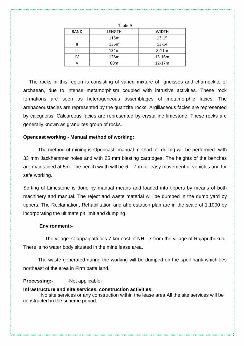
Table-9
BAND LENGTH WIDTH
I 115m 13-15
II 136m 13-14
III 134m 8-11m
IV 128m 13-16m
V 80m 12-17m
The rocks in this region is consisting of varied mixture of gneisses and charnockite of
archaean, due to intense metamorphism coupled with intrusive activities. These rock
formations are seen as heterogeneous assemblages of metamorphic facies. The
arenaceousfacies are represented by the quartzite rocks. Argillaceous facies are represented
by calcgneiss. Calcareous facies are represented by crystalline limestone. These rocks are
generally known as granulites group of rocks.
Opencast working - Manual method of working:
The method of mining is Opencast manual method of drilling will be performed with
33 mm Jackhammer holes and with 25 mm blasting cartridges. The heights of the benches
are maintained at 5m. The bench width will be 6 – 7 m for easy movement of vehicles and for
safe working.
Sorting of Limestone is done by manual means and loaded into tippers by means of both
machinery and manual. The reject and waste material will be dumped in the dump yard by
tippers. The Reclamation, Rehabilitation and afforestation plan are in the scale of 1:1000 by
incorporating the ultimate pit limit and dumping.
Environment:-
The village kalappaipatti lies 7 km east of NH - 7 from the village of Rajaputhukudi.
There is no water body situated in the mine lease area.
The waste generated during the working will be dumped on the spoil bank which lies
northeast of the area in Firm patta land.
Processing:- -Not applicable-
Infrastructure and site services, construction activities: No site services or any construction within the lease area.All the site services will be constructed in the scheme period.

ECONOMIC AXIS – E 1 1 Detailed exploration : The Firm has performed detailed exploration to know the behaviour
of lime stone at various depths.
2. Mining report/mining plan/working mines
Scheme of mining and progressive mine closure plan have been prepared for the
period 2017 – 18 to 2021 – 22. A production quantity of 2325CUM (6046 tonnes) of
limestone is recoverable and the same has been planned for each year by raising lime stone
manually and mechanically.
3. Specific end – use grades of reserves
The lime stone in this area is having good economic value in lime based industries for
burning and grinding. The quality of limestone is generally good as the chemical analysis of
the Limestone is :
Grade of Limestone:
The grade of Limestone is found to be of CEM grade. The average analysis of
Limestone as analyzed in the Bombay Test House Pvt. Ltd is tabulated below:
Table-10(Sample No-1)
LIMESTONE
Parameter Composition %
CaO 16.67
MgO 35.93
Table-11(Sample No-2)
LIMESTONE
Parameter Composition %
CaO 32.88
MgO 16.89
Table-12(Sample No-3)
LIMESTONE
Parameter Composition %
CaO 33.88
MgO 17.80
Based on the analysis, the quality of Limestone ranges between 32 to 36 of CaO.
As analyzed in the laboratory, Limestone, which has more than 60% CaCO3, is best

suited for CEM industries, the grade below 30% of CaCO3 with contaminations of
shells; marl and clay are considered as mineral reject in these particular formations.
4 Costing: Table-13
Details on operating costs are given below.
Sale value of Limestone : Rs.400/-
5 Marketing:
The mined out limestone is being marketed to various need based industries in and
around Tamil Nadu
6 Economic viability: a) The Limestone is having good economic viability in lime based industries for producing
CEM and 20 micron size grinding units.
b) Description of Regional geology with reference to location of lease / applied area.
The Limestone deposit of Kalappaipatti limestone mines belongs to metamorphic
crystalline varieties of Achaean Age. The Limestone bands traverse in NW-SE direction.
Limestone is occurring as a discontinuous linear body in the mining lease area. Limestone
band is striking NW - SE Direction and dipping towards NE with an angle of 80o.
It has undergone heavy tectonic disturbances resulting, the formation of folded
structure. The lime stone is medium grained to coarse, grained in nature and there are
intrusions of country rock within the lime stone body.
The recovery of lime stone is 80% over the R.O.M. The inter burden rejects are
Calcgneiss, calcgranulite & charnockite. The foot wall and hanging wall sides comprise of
Calcgneiss. .
c)Detailed Description of geology of the lease area such as shape and size of the
mineral / ore deposit, disposition various litho- units indicating structural features if
any etc.(Applicable for Mining Plan for grant & renewal and not for Scheme of Mining /
Modifications in the approved mining plan /scheme of Mining)
Sl.No
Particulars
Cost of Production Per Tonne
Manual
Mechanical- (Development work & waste)
1. Labour charges 64/- 25/-
2. Royalty paid to Mines & Geology 80/-- -
3. Explosives expenses 20/- 15/-
4. Drilling expenses 25/- 20
5. Transport from mine head to stockyard 18/- 18/-
6. Miscellaneous and overhead 25/- 10/-
Total 232/- 88/-

Not applicable
d)(i) Name of the prospecting/ exploration agency:
Surface Geological mapping, surveying & prospecting were carried out
departmentally. The team consists of Geologist and Surveyor. They are carrying prospecting
works.
(ii)Address : N. Ravinthiran,
1699/1, Madurai Road, Opp. ABCOY Garden
Sankar Nagar (Post), Tirunelveli - 627 357.
(iii) E mail Address : [email protected]
Mobile : 9842126699.
e) Details of Prospecting/ Exploration Already carried out in the area: Details of exploration already carried out.
The applicant had done preliminary investigations in the past like pitting, trenching and
drilling bore holes.
The mine has attained 11.0 m depth and the drilled borehole carried out in the lease
area has proved the depth of mineralization upto 11m and hence, the proved reserves
related to have been considered upto 11 m depth for calculating the Resource and Reserves
during the present scheme period.
i) Number of pits and trenches indicating dimensions, spacing etc along and across
the strike / foliation with reference to geological plan.
As it has been specified in the modified mining plan, development work is undertaken to win
the Limestone. At present, there are five existing pits and its dimensions are:
Table-14
Pit holes Length (M) Width (M) Depth (M)
Pit no – I 26 22 11.0
Pit no – II 40 24 11.0
Pit no – III 66 26 2.0
Pit no – IV 82 36 6.0
Pit no – V 48 22 6.0

ii) Number of bore holes indicating type (Core/RC/DTH), diameter, spacing, inclination,
collar level, depth etc with standard bore hole logs duly marking on geological plan/
sections.
The area is very small. The attitude of the limestone band like width and length are
clearly known. Depth persistence of limestone in this area was proved to be 11.0 m from
ground level.
Based on the existing working pit results, in strike line, from pit no : 4 to south east, pit
no : 5 is mined.
Due to the lack of market demand, non – continuous workings and non – availability of
labour, lack of bulk orders from industries like manufacturing of mineral powder for Soap,
paints, detergent industries etc., the proposed and proved quantity was not mined in the
modified mining plan period. Hence the proved quantity of the approved mining plan will be
taken in the scheme of mining period of 2017 – 18 to 2021 – 22. In this scheme of period, in
pit no : 5 alone, one diamond borehole upto the depth of 11.0 m has been proposed.
Locations of drilled borehole and proposed borehole are marked in the geological plan and
sections and year wise plan and sections (Refer Plate No. V)
iii) Details of samples analysis indicating type of sample (surface/sub-surface from
pits/trenches/borehole etc):
Limestone Powder samples were collected and tested in the Bombay Test House Pvt.
Ltd. in Salem.
iv) Expenditure incurred in various prospecting operations:
Drilling cost Rs.230/meter drilling by rotary drill.
f) The surface plan of the lease area may be prepared on a scale of 1:1000 or 1:2000
with contour interval of maximum of 10m depending up on the topography and size of
the area duly marked by grid lines showing all features indicated under Rule 28(1) (a)
of MCDR 1988.
Topographical survey and geological mapping were carried out and prepared surface
plan with one meter contour interval. The surface, Geological Plans is 1:1000 scale is given
in Plate No. IV&V.
g) For Preparation of geological plan, surface plan prepared on a scale of 1:1000 or
1:2000 scale specified under Para 1.0 (f) of Part A of the format may be taken as the
base plan. The details of exploration already carried out along with supporting data for

existence of mineral, locations proposed exploration, various litho units along with
structural features, mineralized/ore zone with grade variation if any may be marked on
the geological plan along with other features indicated under Rule 28(1) (b) of MCDR
1988.
Surface, Geological Plan prepared in the scale of 1:1000 and Geological cross section
1:1000 are enclosed in Plate No V.
h) Geological sections may be prepared on natural scale of geological plan at suitable
interval across the lease area from boundary to boundary.
Five cross sections are drawn width wise (A-A‟), (B-B'), (C-C‟), (D-D‟) & (E-E‟) and one
longitudinal section drawn length wise (P – Q) in the Geological plan . (Plate No V).
i) Broadly indicate the future programme of exploration with due justification
(duly marking on Geological plan year wise location in different colours)
taking in to consideration the future tentative excavation programme planned
in next five years as in table below:-
Proposal of Exploration:
Table-15
Year No.of Boreholes (Core/RC/DTH)
Grid Interval Total Meterage No.of Pits and Dimension
No.of Trenches and Dimensions
2017-2018
5 PDDH 50m 55 Nil Nil
2018-2019
- - - Nil Nil
2019-2020
- - - Nil Nil
2020-2021
- - - Nil Nil
2021-2022
- - - Nil Nil
j) Reserves and resources as per UNFC with respect to the threshold value notified by
IBM may be furnished in a tabular form as given below: ( Area explored under different
level of exploration may be marked on the geological plan and UNFC code for area
considered for different categories of reserve/resources estimation may also be
marked on geological cross sections).Submit a feasibility/pre-feasibility study report
along with financial analysis for economic viability of the deposit as specified under
the UNFC field guidelines may be incorporated.

BENCH LOCKED RESOURCES FOR LIMESTONE UNDER UNFC CODE 222
Table – 16
Classification
Volume
(Cu.M)
ROM (MT)
Limestone (80%) (Cu.M)
UNFC Code
Bench Locked Resources 9170 23842 7336
222
Mineral Locked Resources for Limestone in 7.5m Boundary Barrier- 222
Table – 17
Classification
Volume
(Cu.M)
ROM (MT)
Limestone (80%) (Cu.M)
UNFC Code
Locked in 7.5m Boundary barrier Resources
5775 15015
4620 222
Category wise updated Reserves and Resources for Limestone is under UNFC Code
Table – 18
Classification
Volume
(Cu.M)
ROM (MT)
Limestone (80%) (Cu.M)
UNFC Code
Proved Mineral Reserves 103250 268450 82600 111
Bench Locked Resources 9170 23842 7336
222
Locked in 7.5m Boundary barrier Resources
5775 15015 4620
222
k) Furnish detailed calculation of reserves / resources section wise:
Available Reserves of Limestone:
For the purpose of estimation of reserves, cross sectional method has been followed
(Cross sectional area x Length of influence in metres x Depth). Five geological cross
sections are drawn at equal interval and one longitudinal section drawn in the strike length
.
The mine has attained 11.0 m depth and we proposed to put drilled borehole carried
out in the lease area has proved the depth of mineralization upto 11m and hence, the proved

reserves related to UNFC 111 have been considered upto 11 m depth (1m top soil + 10 m
limestone) for calculating the Resource and Reserves as per the UNFC System during the
present scheme period. . (Refer Plate No. V).
The insitu volume in cubic meters was then converted in to tonnage by applying
tonnage conversion factor of 2.6 T/Cu.m. Limestone deposit is always associated with
presence of solution cavities, joints/voids and cavity fillings. This deposit is no exception to
these factors and keeping in view all these conditions a recovery factor of 80% for the
purpose of reserve estimation is considered, Further the drill data i.e core recovery also
substantiates that the core recovery is around 80%. The important factors taken into
consideration for reserve estimation is a recovery factor of 80% based on core recovered
during drilling. A tonnage conversion factor of 2.60 T/Cu.m is considered.
Mineable reserve estimation has been calculated taken into consideration 7.5 m safety
zone from mining lease boundary. From the safety limit a 600 angle has been drawn
(considering an equal bench height and width) and the reserves have been estimated
A recovery factor of 80% for reserve estimation is considered based on the
previous mine workings. The proved Mineable Reserves (UNFC 111 Code) for this plan
period in respect of the recoverable limestone is 82600CUM (214760 tonnes) (80%) for the
present Mining Plan period is 2017 – 18 to 2021 – 22.The reserves were estimated upto
11m depth @ bulk density 2.6 during the previous approved modified plan period.
The information‟s gathered from the excavated pits and drilled boreholes were
correlated to discuss the pre feasibility studies and to calculate the resource and reserves
related to G1, E1, F1 axis of UNFC system.
During this scheme period, the reserves are calculated upto11m depth [0m topsoil +
10m limestone (proved 111)] and the resource and reserves are reassessed on 16.03.2017
as per circular 4/2010 issued by the CCOM, Chennai.
The parameters and dimensions which has been considered for the reserve estimation
is given under Proved Mineral Depth (UNFC 111) = 11m
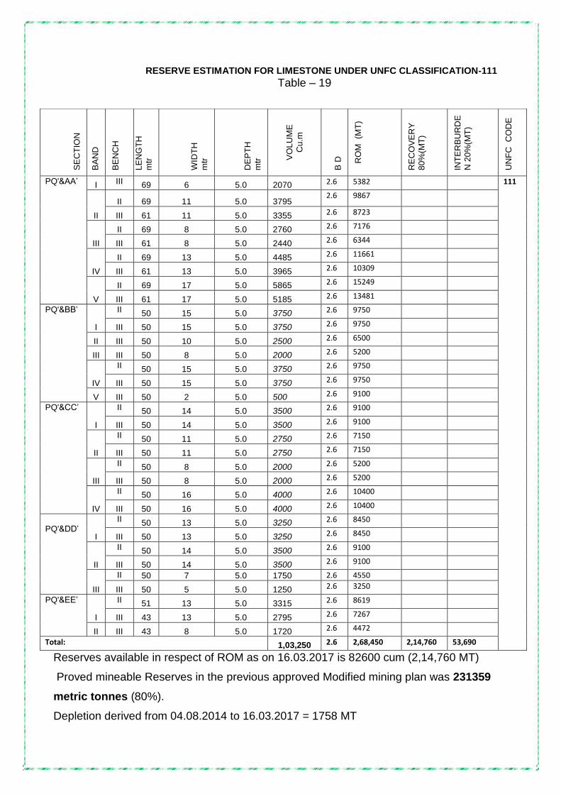
RESERVE ESTIMATION FOR LIMESTONE UNDER UNFC CLASSIFICATION-111
Table – 19
Reserves available in respect of ROM as on 16.03.2017 is 82600 cum (2,14,760 MT)
Proved mineable Reserves in the previous approved Modified mining plan was 231359
metric tonnes (80%).
Depletion derived from 04.08.2014 to 16.03.2017 = 1758 MT
SE
CT
ION
BA
ND
BE
NC
H
LE
NG
TH
mtr
WID
TH
mtr
DE
PT
H
mtr
VO
LU
ME
Cu
.m
B D
RO
M
(MT
)
RE
CO
VE
RY
80
%(M
T)
INT
ER
BU
RD
E
N 2
0%
(MT
)
UN
FC
C
OD
E
PQ'&AA‟ I III 69 6 5.0 2070 2.6 5382 111
II
II 69 11 5.0 3795 2.6 9867
III 61 11 5.0 3355 2.6 8723
III
II 69 8 5.0 2760 2.6 7176
III 61 8 5.0 2440 2.6 6344
IV
II 69 13 5.0 4485 2.6 11661
III 61 13 5.0 3965 2.6 10309
V
II 69 17 5.0 5865 2.6 15249
III 61 17 5.0 5185 2.6 13481
PQ'&BB‟
I
II 50 15 5.0 3750 2.6 9750
III 50 15 5.0 3750 2.6 9750
II III 50 10 5.0 2500 2.6 6500
III III 50 8 5.0 2000 2.6 5200
IV
II 50 15 5.0 3750 2.6 9750
III 50 15 5.0 3750 2.6 9750
V III 50 2 5.0 500 2.6 9100
PQ'&CC‟
I
II 50 14 5.0 3500 2.6 9100
III 50 14 5.0 3500 2.6 9100
II
II 50 11 5.0 2750 2.6 7150
III 50 11 5.0 2750 2.6 7150
III
II 50 8 5.0 2000 2.6 5200
III 50 8 5.0 2000 2.6 5200
IV
II 50 16 5.0 4000 2.6 10400
III 50 16 5.0 4000 2.6 10400
PQ'&DD‟
I
II 50 13 5.0 3250 2.6 8450
III 50 13 5.0 3250 2.6 8450
II
II 50 14 5.0 3500 2.6 9100
III 50 14 5.0 3500 2.6 9100
III
II 50 7 5.0 1750 2.6 4550
III 50 5 5.0 1250 2.6 3250
PQ'&EE‟
I
II 51 13 5.0 3315 2.6 8619
III 43 13 5.0 2795 2.6 7267
II III 43 8 5.0 1720 2.6 4472
Total: 1,03,250 2.6 2,68,450 2,14,760 53,690

Present available additional reserve : Nil
Additional reserves now established:- Nil
Additional reserves established category wise:
The reserves are calculated, leaving allowances for mineral locked in the benches upto the
bottom of the benches. The reserves are calculated assuming the ultimate pit slope of 600.No
additional reserves established during this scheme period. There is no much more deviation
from the approved modified mining plan.
Fresh cross sections were drawn and the reserves are recalculated using the AutoCAD
software.
.
Reassessed Mineral Reserves and Resources as per UNFC System as on 01.04.2015
Table-20
Summary of Reserves & Resources
Description Section ROM
(CUM)
Limestone @ 80% (CUM)
Mineral Rejects
20%(CUM)
Top soil
(CUM)
A. Mineral Reserves (111)
PQ&AA’ 33920 27136 6784 -
PQ&BB’ 20000 16000 4000 -
PQ&CC’ 25000 20000 5000 -
PQ&DD’ 16500 13200 3300 -
PQ&EE’ 7830 6264 1566 -
Total 103250 82600 20650 -
B. Mineral Resources locked
up in benches (222) 9170 7336 1834 -
C. Mineral Resources locked up in 7.5m safety distance(222)
5775 4620 1155 -

I) Mineral Resources : (Mineral resources may be estimated purely based on level of
exploration, with reference to threshold value of minerals declared by IBM)
Mineable reserve estimation has been calculated taken into consideration, 7.5m safety zone
from mining lease boundary. From the safety limit, a 600 angle has been drawn 9considering an
equal bench height and width) & the reservess has been estimated.
The parameters and dimensions which has been considered for the resources estimation is
given under (UNFC 222) = 11 m.
BENCH LOCKED RESOURCES FOR LIMESTONE UNDER UNFC CODE – 222
Table – 21
MINERAL LOCKED IN BOUNDARY BARRIER(RESOURCES)FOR LIMESTONE UNDER CODE–222
Table – 22
BA
ND
LE
NG
TH
M
tr
WID
TH
M
tr
DE
PT
H
Mtr
VO
LU
ME
C
UM
B.D
RO
M (
MT
)
RE
CO
VE
RY
80
%(M
T)
INT
ER
BU
R-
DE
N
20
%
RE
JC
ET
(M
T)
UN
FC
C
OD
E
I 24 7.5 10.0 1800 2.6 4680
222
II 14 7.5 10.0 1050 2.6 2730
III 13 7.5 10.0 975 2.6 2535
IV 12 7.5 10.0 900 2.6 2340
V 14 7.5 10.0 1050 2.6 2730
TOTAL 5775 2.6 15015 12012 3003
The mineral resources (UNFC CODE 222) for this plan in respect of the limestone is as follows :
SE
CT
ION
BA
ND
BE
NC
H
LE
NG
TH
mtr
WID
TH
mtr
DE
PT
H
Mtr
VO
LU
ME
Cu
.m
B D
RO
M
(MT
)
RE
CO
VE
RY
80
%(M
T)
INT
ER
BU
RD
E
N 2
0%
(MT
)
UN
FC
C
OD
E
PQ'&AA‟
I II III
69 61
4 11
5.0 5.0
1380 3355
2.6 2.6
3588 8723
222
PQ'&CC‟ V III 50 10 5.0 2500 2.6 6500
PQ‟ & EE‟ II III 43 9 5.0 1935 2.6 5031
TOTAL 9170
2.6 23842 19073.6 4768.4

Mineral resources (Bench locked reserves)- 21250cubic metres (55250 MT at 80%)
Mineral resources (Locked in Boundary barrier)- 4620 cubic metres (12012 MT at 80%)
Total mineral resources (UNFC CODE 222)- 25870 Cubic metres (67262 MT at 80%)
Table-24
Category wise updated Reserves and Resources for Limestone is under UNFC Code
Table – 23
Classification
Volume (Cu.M) ROM (MT)
Limestone (80%) (Cu.M)
UNFC Code
Proved Mineral Reserves 103250 268450 82600 111
Bench Locked Resources 9170 23842 7336 222
Locked in 7.5m Boundary barrier Resources
5775 15015 4620
222
Resources and Reserves within the lease may be arrived after applying results
feasibility/prefeasibility study and economic evaluation of deposit based on various
factors such as :-
a) Mining method, recovery factor, mining losses processing loss etc :
The insitu volume in cubic meters was converted in to tonnage by applying tonnage
conversion factor of 2.6 T/ Cu.m. Limestone deposit are always associated with presence of
solution cavities, joints/voids and cavity fillings. Further the drill data i.e core recovery also
substantiates that the core recovery is around 80%. The important factors taken into
consideration for reserve estimation is a recovery factor of 80% based on core recovered
during drilling. A tonnage conversion factor of 2.60 T/Cu.m is considered.
The ultimate pit boundary of the area is shown in the Conceptual Mining plan and in
Conceptual Mining Cross Sections.
Length .. 268 metres
Width .. 61 metres
Depth .. 11 metres
Final Slope angle adopted: The ultimate pit slope angle is 600
Level of Exploration Resources in Cum Grade
G1- Detailed exploration 25870 Cem Grade (Lime based industry grade)
G2- General exploration -.- -.-
G3 –Prospecting -.- -.-
G4 – Reconnassance -.- -.-

b)Cut off grade, Ultimate pit depth proposed :
Grade specification: For Limestone:-
The lime stone in this area is having good economic value in lime based industries for
burning and grinding. The quality of limestone is generally good as the chemical analysis of
the Limestone is as follows
Grade OF Limestone:
The grade of Limestone is found to be of CEM grade. The average analysis of
Limestone as analyzed in the Bombay Test House Pvt Ltd is tabulated below:
Table-25(Sample No-1)
LIMESTONE
Parameter Composition %
CaO 16.67
MgO 35.93
Table-26(Sample No-2)
LIMESTONE
Parameter Composition %
CaO 32.88
MgO 16.89
Table-27(Sample No-3)
LIMESTONE
Parameter Composition %
CaO 33.88
MgO 17.80
c) Mineral / Ore blocked dues to benches and barriers: (Limestone)
Table – 23
Classification
Volume
(Cu.M)
ROM (MT)
Limestone (80%) (Cu.M)
UNFC Code
Bench Locked Resources 9170 23842 7336
222
Locked in 7.5m Boundary barrier Resources
5775 15015 4620
222

2.0 MINING:
A. OPEN CAST MINING
a) Briefly describe the existing as well as proposed method for excavation with all
design parameters indicating on plans and sections.
The method of working is an opencast Mining operation. It is proposed to work by
adopting 5 metres bench height and a width of more height of benches of 5metre, with an
ultimate pit slope of 60. The ramp gradient shall be kept minimum of 1 in16. Mining is
performed by open cast method. Systematic mine development and winning of limestone
mineral is planned upto a depth of 36mts. The contract labourers are deployed for manual
segregation for the purpose of loading. The rejects will be handled by the excavators and will
be loaded into10 Ton Tipper. The excavators and the Tippers are engaged on hire basis.
Development:
The main works comprising are - overburden removal, drilling of holes and blasting..The
mining lease area is covered with 0.5 metre to 1.0metre thick soil. During the present scheme
period there is no topsoil would be generated and it is proposed.
Drilling:
Jackhammer drilling is performed in a small holes of 33 mm diameter and the same
will be drilled to a maximum depth of 1.5metre to 2 metre, depending upon the bench height.
Loading:
The bench height has been planned for 5 metre. The limestonewill be loaded
manually..Waste and rejects will be handled by excavator for loading into the tippers of 10
tonnes capacity.
Hauling/Transport ::
The ROM of limestone is straight away loaded into to the tippers by means of machinery and
transported to the temporary stock yard. From that stock yard, the sorted limestone like
magnesia and Siliceous limestone are transported to own industry and needy lime based
industry in Tamil Nadu depending upon their requirements through privately hired lorries.

BLASTING:
The mine is working by manual and mechanical means. The drilling will be carried out by
using jackhammer drilling with 33 mm dia holes. The holes will be charged with special
gelatin and will be detonated by special plain detonators with safety fuse or by electric
detonators. Generally the blast hole pattern in production and development faces will be
having a spacing of 1.6m and 1.2 m burden. The depth of the hole will be 2.0 m. The Powder
factor for production and development will be 7.68 t/kg and average charge per hole will be
0.65 kg..Two holes in a block will be 1.30 kg. The bulk density is 2.6insitufor both production
and development. The calculation for arriving Powder Factor is as follows:
Broad Blasting Parameters: - for manual work
Ordinary of Explosives to be used:
Spacing : 1.6 m
Burden : 1.2 m
Depth : 2.0 m
Bulk density : 2.6 ts/cu.m
Total quantity : 1.6 x 1.2 x 2.0 x 2.6 = 9.98 ts
Charges per hole : 0.650 kg x 2 holes = 1.30
That is 1.30 kg of explosive will generate 9.98 tons of material therefore, 1 kg of explosive will generate.
9.98 / 1.30 = 7.68 tons /kg
Type of Explosives Used:
The drill holes will be charged with special gelatine, detonated with special plain detonator,
safety fuse and with electric detonators.
Storage of Explosives:
The explosives are being drawn from the authorised explosive dealer. The required
quantum of explosives will be planned well in advance and as such there is no scope of
returning the excess quantity or otherwise.

Mechanised operation:
Mechanisation for development work
The mine is working by manual method under „B‟ category .The drilling will be carried out by
using jackhammer drilling with 33 mm dia holes. The holes will be charged with special
gelatin and will be detonated by special plain detonators The holes are connected by
detonating fuse and will be blasted with electric detonators. The blasted materials will be
handled through hired excavators and loaded into dippers. The materials will be dumpedon
the top of the surface, where good grade lime stone and rejects have also been sorted out
manually. The good grade of lime stone will be marketed to the needy industries and the
rejects will be loaded through hired track shovel and dumped in the dump yard. An estimated
production of 1744 CUM (4535 tonnes) per year will be generated both by manual and
mechanical methods.
The generation of rejects during development is shown in year wise production and development schedule.
The existing machinery details:
Table :20
b)Indicate Year –wise tentative Excavation in Cubic Meters indicating development,
ROM, Pit wise as in table below :
Year wise production schedule for the ensuing 5 years.
The mining scheme is being submitted under Rule 12(3) of MCDR -1988. During this plan
period it is envisaged to win limestone from the area between three cross sections(A-A‟), (B-
B'), (C-C‟), are drawn with wise and one longitudinal section along (P – Q) length wise .
(Plate No VI).Accordingly, development works will be carried out in respective areas so as to
expose the limestone.In this five years plan period, it is proposed to exploit the limestone
mineral at the rate of average 2325CUM (6046 tonnes) per year. Details of overburden ,
1 Excavator cum loader (hired) 1
2 Tractor mounted compressor with Jack Hammer drill (hired)
1
3 Generator (hired) 1
4 10 Tonns Tippers (hired) 2
5 Dewatering pumps 20 HP 1

Side burden, removal of ROM and useable limestone mineral production etc., in the ensuing
five years are as follows :
I. Insitu Tentative Excavation: (Limestone)
Table :21
Year Pit No
Total tentative Excavation (Cum)
Top Soil
(Cum)
(A)
Side Burden
(Cum)
(B)
ROM(Cum) Total
reject
(Cum)
(A+B+C)
ore/
Waste
Ratio
Ore 80%
(Limestone)
(Cum)*
Interburden
reject 20% (Cum)
(C)
1 2 3 4 5 7 8 9 10
2017-18 - 4705 725 1655 3764 941 3321 1:0.88
2018-19 - 5720 550 1870 4576 1144 3564 1:0.77
2019-20 - 4730 550 1320 3784 946 2816 1:0.74
2020-21 - 4730 550 1320 3784 946 2816 1:0.74
2021-22 5852 792 1870 4681.6 1170.4 3832.4 1:0.81
Total: 25737 3167 8035 20589.6 5147.4 16349.4 1:0.79
*Tentative tonnage of the ore may be arrived by computing approximate bulk density
and recovery factor as these data arevariable and may be established on time series.
The insitu volume in cubic meters is converted in to tonnage by applying tonnage
conversion factor of 2.6 T/ Cu.m. Limestone deposits are always associated with presence of
solution cavities, joints/voids and cavity fillings. This deposit is no exception to these factors
and keeping in view all these conditions a recovery factor of 60% for the purpose of reserve
estimation is considered. Further the drill data i.e core recovery also substantiates that the
core recovery is around 80%. The important factors taken into consideration for reserve
estimation is a recovery factor of 80% based on core recovered during drilling. A tonnage
conversion factor of 2.60 T/Cu.m is considered.

II Dump re-handling ( for the purpose of recovery of mineral)
Does not arise During the plan period 2017-18 to 2021-22.
Table :22
Dump
identification/No
Yearwise
handling(Cum)
Estimated recovery of
saleable material (Cum)*
Reject (Cum)
-NIL- -NIL- -NIL- -NIL-
* Tentative tonnage of the saleable material may be arrived by computing
approximate bulk density and recovery factor as these data are variable and may be
established on time series.
c) Individual yearwise development plans and sections :
Year- wise production plan proposed for next five years (2016-2021) for Limestone
Table :23
Year Limestone Production 80% saleable
Limestone in
MT
20% Mineral
rejects in MT Volume in
CUM
Bulk density ROM in MT
2017-18 2325 2.6 6045 4836 1209
2018-19 3300 2.6 8580 6864 4675.0
2019-20 2860 2.6 7436 5948.8 1487.2
2020-21 2860 2.6 7436 5948.8 1487.2
2021-22 3190 2.6 8294 6635.2 1658.8
Total 14535 2.6 37791 30232.8 7558.2

YEAR WISE PRODUCTION AND DEVELOPMENT SCHEDULE FOR LIMESTONE
Table-24
YEARWISE DEVELOPMENT AND PRODUCTION
YEA
R
SEC
TIO
N
BA
ND
BEN
CH
DIMENSION
VO
LUM
E
BU
LK
DEN
SITY
RO
M(T
s)
Lim
est
on
e
80
%
Rec
ove
ry(T
s)
Min
ed W
aste
20
%(T
s)
Sid
e B
urd
en
Top
So
il
L(m)
W(m)
D(m)
2017-18
PQ-CC’
IV
I 29 25 1.0
725
2.0
- - - - 1450
II 23 15 5.0 1725 2.6
4485
II 23 13 5.0 1495 2.5
- - - 3737.5 -
III 8 15 5.0 600 2.6
1560
III 8 4 5.0 160 2.5
- - - 400.0 -
TOTAL 4705 6045 4836 1209 4137.5 1450
2018-19
PQ-CC’
IV
I 22 25 1.0 550 2.0
- - - - 1100
II 22 15 5.0 1650 2.6
4290
II 22 13 5.0 1430 2.5
- - - 3575.0
III 22 15 5.0 1650 2.6
4290
III 22 4 5.0 440 2.5
- - - 1100.0 -
TOTAL 5720 8580 6864 1716 4675.0 1100
2019-20
PQ-BB’
IV
I 22 25 1.0 550 2.0
- - - - 1100
II 22 13 5.0 1430 2.6
3718
II 22 10 5.0 1100 2.5
- - - 2750 -
III 22 13 5.0 1430 2.6
3718
III 22 2 5.0 220 2.5
- - - 550
TOTAL 4730 7436 5948.8 1487.2 3300 1100
2020-21
PQ-BB’
IV
I 22 25 1.0 550 2.0
- - - - 1100
II 22 13 5.0 1430 2.6
3718
II 22 10 5.0 1100 2.5
- - - 2750 -
III 22 13 5.0 1430 2.6
3718
III 22 2 5.0 220 2.5
- - - 550
Total 4730
7436 5948.8 1487.2 3300 1100
2021-22
PQ-AA’
IV
I 22 36 1.0 792 2.0
- - - - 1584
II 22 13 5.0 1430 2.6
3718
II 22 15 5.0 1650 2.5
- - - 4125 -
V III 22 3 5.0 330 2.6
858
IV III 22 13 5.0 1430 2.6
3718
III 22 2 5.0 220 2.5
- - - 550 -
Total
5852 8294 6635.2 1658.8 4675 1584
GRAND TOTAL 25737
37791 30232.8 7558.2 20087.5 6334

d)Salient features of the proposed method of working:
The method of working is under opencast manual „B‟ category mine considering various
technical parameters like surface topography, continuation of limestone deposits, quality
variations and geo-technical aspects, required rate of production etc. It is proposed to work
this deposit by adopting 7.5m bench height and width of more than the height of benches i.e
more than 7.5 m, with an ultimate pit slope of 60°. Mining is being carried out by open cast
method. Systematic mine development, winning of limestone mineral is planned by taking
into consideration of present economic mineable depth of 36 m in this mine. Based on the
disposition and the width of the limestone body, the ultimate pit limit of is arrived accordingly.
The side wall development will be carried out with the help of
deep hole drilling, blasting and excavation come loader. During production, deep hole
drilling and blasting will be adopted. For secondary blasting jack hammer holes will be
used. Limestone benches will be formed slices of 5m and will be merged as 10m as the
bench reaches the side wall.
The side wall development will be carried out with the help of excavators, tippers and
dozers and the height of the benches in development is being maintained as 10m, which
would be the safe working height of excavators deployed. Specific permission from
Directorate of Mines safety has been obtained for adopting a system of deep hole blasting
and for usages of heavy machinery for digging, excavation and removal of ore etc. under
regulation 106 (2) (b) of Metalliferous Mines Regulation 1961.
From this mine, a quantity of 2325CUM (6046 tonnes) of Limestone per year now
being mined. Only manual mining is being adopted with 32 mm jack hammer drilling and
blasting using 25mm cartridges. Since the deposits occurs in three liner bands of Limestone
with heavy intercalations. This necessitates deploying manual labours for sorting out the
limestone.
The blasted ROM is segregated manually and the sorted out - limestone is loaded
into the 10 trucks for transporting to the lime based industries. A production quantity of
2325CUM (6046 tonnes) per annum have been planned for the period 2017-18 to 2021-22.
The face position at the beginning of first year production and development plan for the five
years are shown in Plate No VI .
The mining will be carried out by means of Open Cast Mechanized method with the
conventional system of mining, which includes drilling, blasting, loading, and transportation.

Proper benches are being formed in accordance with Reg.106 of MMR, 1961. The bench
height in topsoil is about 1m and mineral benches are kept at 5m height. The bench slopes
are maintained at 60° from horizontal in mineral bench and bench width will always be more
than the height i.e. 5m. The haul roads are cleaned and kept in 1:16 gradients for smooth
movement of tippers/ hired trucks used for transportation of mineral.
Ten benches are proposed to form at 5m height and 6m to 7m width with 60o slope.
The mineral rejects is proposed to be dumped separately on the South side of the
mining lease area earmarked. Proper foot- paths will be made between benches for the
easy access of face workers to carry out the ROM from the mine.
The waste is proposed to be loaded manually into tippers or occasionally by loaders to
the dumping yard (when there is a shortage of labour) to the northwest side of the mining
lease area.
Afforestation is proposed in the western side of the 7.5m boundary barrier.
The topsoil is proposed to be dumped separately in the South West in the ear marked area.
If there is any change in the system of mining, the same will be intimated to Indian
Bureau of Mines and the mining scheme will be suitably modified for subsequent clearance
and approval. Please refer the yearwise development and production plans and sections
(Plate No.VI).
List of Mining Machinery Under Utilization:
Table -25
Sl.No Description Number
1 Excavator cum loader (hired) 1
2 Tractor mounted compressor with Jack Hammer drill (hired)
1
3 Generator (hired) 1
4 10 Tonns Tippers (hired) 2
5 Dewatering pumps 20 HP 1
Surface Transport:
The loading is by manual means into tippers for the movement of the High grade
limestone and Inferior grade Limestone. The materials will be shunted near Office yard for

dispatch to the needy industries& customers. The side wall development is carried out by
similar drilling and blasting method & the waste material is being dumped on the dump area.
e) Describe briefly the layout of mine workings, pit road layout, the layout of faces and
sites for disposal of overburden / waste along with ground preparation prior to
disposal of waste, reject etc., A reference to the plans and sections may be given. UPL
or ultimate size of the pit is to be shown for identification of the suitable dumping site.
f) Conceptual Mining planning upto the end of lease period taking into consideration
the Present available reserves and resources describing the excavation, recovery of
ROM, and Disposal of waste backfilling of voids,reclamation and rehabilitation
showing on a plan with few relevant sections.:
Conceptual Mining plan has been prepared after taking into consideration the depth
persistence of limestone deposit, mineability and economics including recovery of limestone
etc which are shown in conceptual plan and sections. The face position at the end of the life
of the mine, proposed dump sites are also displayed in the plan(Refer plates IX).Mining
operations will be performed up to 5 years with the capacity of production as shown in the
table given below and the dumps could be reclaimed before suitable afforestation techniques
are adopted. Refilling programme can only be worked after exhaustion of the mineral in the
lease. The ultimate pit dimension is - length 268 m, width 61m (Avg) and depth 11m.
Anticipated life of the mine: Available mineral reserves ROM
UNFC 111 (reassessed on 16.03.2017) = 82600 cum (214760 MT)
Proposed annual production ROM = 2325CUM (6046 tonnes)
Anticipated life of the mine = 2325 / 82600
= 35.5 Years
Optimum exploitation & utilization of the mineral
The mining lease area consists of 4.70.0 Ha, after leaving 7.5m boundary barrier only
0.74.6 Ha could be mined. Out of this only 0.59.1 Ha is proposed for an optimum depth of
maximum 36 m has been taken into consideration for the utilization of the mineral in the

Present scheme period, keeping in the view of mineral conservation, preservation and development.
Anticipating the market demand this present quantity of exploitation is proposed during the present
scheme period.
Available mineral reserves ROM
Available mineral reserves ROM
UNFC 111 ( reassessed on 16.03.2017) = 85000 cum (221000 MT)
Proposed annual production of ROM = 2325 cum (6046 tonnes)
Anticipated life of the mine = 2325 / 85000
= 36 years
No. of working days in a year = 250 days
Average monthly production = 6046 tonnes / 12
= 50 tonnes
Anticipated daily production = 50 / 25
= 2 tonnes / day
No. of working hours per day = 8 am to 5 pm with 1 hr lunch interval
Total no. of labours to be engaged = 3
OMS =
= 2 / 3 = 0.6 Ts
Proposed dump dimensions :
TOP SOIL STORAGE : Length – 30m , Width – 30m, Height – 2m
SIDE BURDEN DUMP : Length – 50m , Width – 28m, Height – 4m
Waste & sub – grade mineral management
There is no sub grade mineral in the mine. The anticipated waste during the present scheme period
is about 20087.5 tonnes (20% mineral rejects). The mineral rejects is proposed to be dumped on the
north side of lease area. There is no top soil in the present scheme.
This aspect has been considered and accordingly Conceptual mining Plan is drawn. There is
an adequate space available for dumping the top soil and mineral rejects in the lease area. The
quantity of waste generation may be sold out to needy road contractors by getting the permission
from the state government.

Proposed generation of waste for next five years (2017-18 to 2021-22)
Table :21
YEAR Top Soil
(Cum)
(A)
Side Burden
(Cum)
(B)
Interburden
reject 20% (Cum)
(C)
Total
reject
(Cum)
(A+B+C)
2017-18 725 1655 941 3321
2018-19 550 1870 1144 3564
2019-20 550 1320 946 2816
2020-21 550 1320 946 2816
2021-22 792 1870 1170.4 3832.4
3167 8035 5147.4 16349.4
3.0 MINEDRAINAGE:
a) Minimum and maximum depth of water table based on observations from nearby
wells and water bodies:
The average rainfall of this area is around 400mm per annum. The water table in the
surrounding areas is below 40 to 45 metres from the ground level.
The area receives rain during north east monsoon due to frequent failure of monsoon the
area obtained scanty rain fall.
b) Indicate maximum and minimum depth of workings:
The present mining has gone to a maximum depth of 11m and minimum depth of 1m.
c) Quantity and quality of water likely to be encountered, the pumping arrangements
and places where the mine water is finally proposed to be discharged:
There are possibilities of accumulation of rain water during rainy season. The mine is
not having any traces of moisture in the existing depth. The rain water accumulated during
rainy season will be observed by the ground surface. However the excess rain water
accumulated in the mine will be pumped out using 20 HP diesel pump.There is no discharge
of effluent or used water from the mine in the normal course. However at the much later

stage when the pit advances below water table, dewatering process is required.. Hence, no
deterioration of ground water or surface water is anticipated. The quality of discharged water
is expected to be within the Tolerable Limits for Industrial Effluents (IS : 2490), 1981 and the
Indian Standards/Specifications for Drinking Water (IS : 10500), 1983.
d) Describe regional and local drainage pattern. Also indicate annual rain fall,
catchments area, and likely quantity of rain water to flow through the lease area,
arrangement for arresting solid wash off etc:
There is no proper drainage pattern noted in this area. The area has an average
rainfall of 300-400 mm spreading over from of September to December. This area
experiences rain during the North-East monsoon period.
4.0 STACKING OF MINERAL REJECTS / SUB GRADE MATERIAL AND DISPOSAL OF
WASTE:
a) Indicate briefly the nature and quantity of top soil, overburden / waste and
Mineral Reject to be disposed off :
Limestone produced from this mining lease area is of complete Cem grade
(limestoned based industry grade) and average grade only. No sub grade mineral generation
is anticipated during the mining operations. Hence no sub grade mineral dumps would be
created in the life period of the mine.
Top soil:
The top soil is block red soil. The generation of top soil for first five years is about 3167
CUM
Side burden:
The side burden consists of Charnockite. The generation of side burden for first five
years is about 8035 CUM
Sub -grade Mineral:
Not applicable
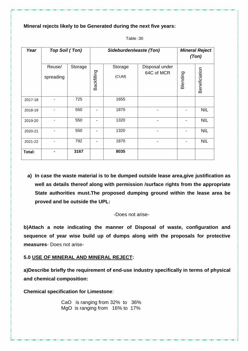
Mineral rejects likely to be Generated during the next five years:
Table :30
Year Top Soil ( Ton) Sideburden/waste (Ton) Mineral Reject
(Ton)
Reuse/
spreading
Storage
Ba
ckfilli
ng
Storage
(CUM)
Disposal under
64C of MCR
Ble
nd
ing
Be
ne
ficia
tion
2017-18 - 725 1655
2018-19 - 550 - 1870 - - NIL
2019-20 - 550 - 1320 - - NIL
2020-21 - 550 - 1320 - - NIL
2021-22 - 792 - 1870 - - NIL
Total: - 3167 8035
a) In case the waste material is to be dumped outside lease area,give justification as
well as details thereof along with permission /surface rights from the appropriate
State authorities must.The proposed dumping ground within the lease area be
proved and be outside the UPL:
-Does not arise-
b)Attach a note indicating the manner of Disposal of waste, configuration and
sequence of year wise build up of dumps along with the proposals for protective
measures- Does not arise-
5.0 USE OF MINERAL AND MINERAL REJECT:
a)Describe briefly the requirement of end-use industry specifically in terms of physical
and chemical composition:
Chemical specification for Limestone:
CaO is ranging from 32% to 36% MgO is ranging from 16% to 17%
Physical specification for Limestone: Colour : White and honey
Form : Crystalline
Hardness : 3-4
Specific gravity: 2.6
Lustre : Vitreous
Fracture : uneven
b) Give brief requirement of intermediate industries involved in up gradation of mineral
before its end-use: Not applicable.
c) Give detail requirements for other industries, captive consumption, export,
associated industrial use etc.,
The Lime stone mined will be utilised to own industry and sold out to the lime based industries in Tamil Nadu for the purpose of burning, grinding and powdering. Others will be dumped in the dump yard..
d) Indicate precise physical and chemical specification stipulated by buyers: There is no specification by the buyers.
e) Give details of process adopted to upgrade the ROM to suit the user requirements:
Processing and up gradation is not applicable.
6.0 PROCESSING OF ROM AND MINERAL REJECT:
a) If processing / beneficiation of the ROM or mineral Reject is planned to be
conducted, briefly describe nature of processing / beneficiation. This may indicate
sizeand grade of feed material and concentrate (finished marketable product),
recovery etc.,
Not applicable.
b) Give material balance chart with a floe sheet or schematic diagram of the
processing procedure indicating feed, recovery, and its gradeat each stage of
processing:
Not applicable.
c) Explain the disposal method for tailings or reject from the processing plant:
Not applicable.
d) Quantity and quality of tailings / reject proposed to be disposed, size and capacity
of tailing pond, toxic effect of such tailings, if any, with process adopted to neutralize
any such effect before their disposal and dealing of excess water from the tailings
dam:
Not applicable.
e) Specify quantity and type of chemicals if any to be used in the processing plant:
Not applicable.

f) Specify quantity & type of chemicals to be stored on site / plant: Not applicable.
g) Indicate quantity (Ton per day) of water required for mining and processing and
sources of supply of water, disposal of water and extent of recycling. Water balance
chart may be given: Does not arise. Water is derived from well for drinking purpose.
7.0 OTHER :
a) Site Services:
The necessary infrastructures such as office, rest shed, First aid station, Drinking
water (RO), store room, Public convenience etc., mines office, blaster shelter and Latrines
have been provided. Besides, helmets and shoes are regularly provided to the workers.
b) Employment potential :
The mine is managed by a Second Class Mines Manager. Adequate Mine foreman,
Mining mate and blasters are available for supervision and blasting. In addition the Firm is
also having Geologist and trainee surveyors. All the relevant statutory provisions are being
meticulously observed.
ORGANIZATION CHART
GEOLOGIST (PART TIME) MINES MANAGER OFFICE CLERK MINES FOREMEN BLASTER DRILLER
MINE WORKERS
Clerical and Supervisory 4 Nos. Skilled 2 Nos. Unskilled(Contractors) 8 Nos. Total 14 NOS.
Proprietor
ADMINISTRATIVE TECHNICAL MINING

PROGRESSIVE MINE CLOSURE PLAN UNDER RULE 23 OF MCDR’ 1988
8.1 ENVIRONMENTAL/ BASE LINE INFORMATION :
The ML area is a flat and dry ground with a flat slopping towards north. Only Seasonal
cultivation is done. The main crops are cotton, Maize, cereals etc.
Ground water is at a depth of 45m in summer and at 40m in Northeast monsoon
Winterseason. The average / annual rainfall is around 600mm.
No wild life or bird sanctuary is existing near the area. There is no any reserve
protected or social forest near the area.
Mining in this area does not produce any harmful effluent affecting the atmosphere or
water regime.
Wet drilling will be carried out. Haul roads will be periodically sprayed with the tractor
mounted water sprinklers and thereby there is no scope for dust problems in this area.
Blasting will performed in a very small scale and heavy earth moving equipment will
not be deployed. Hence, there is no possibility of any noise, pollution and vibration nuisance.
The area derives rain during NE monsoon. The temperature in summer shoots above
400 C in the months of April, May and June and its drops down to 220 C in December,
January and February.
The wind direction is from NE-SW and vice-versa.
The nearby hamlets are :
Table-31
Name of Hamlet Direction from the area Distance
Therkkumailodai
Veppankulam
Rajapudukudi
Ammalpatti
North
South
West
East
3 .0km
1.0 km
4.0 km
2.5 km
There is no public building / places or worship / archaeological/ or national monuments near the area.

Existing land use Pattern ::
The present land use pattern of the lease area is :
Table-32
S.
No
Description
Present
Area
(Hectare)
Area to be
reclaimed and
rehabilitated at
the end of present
MP/MS period
Area to be
reclaimed and
rehabilitated at
the end of the life
of mine
1 Mining (Quarry) 0.72.5 - ..
2 Waste Dump 0.30.8 .. ..
3 Office infrastructure Nil - -
4 Processing Plant Nil - -
5 Mineral stack Processing yard Nil - -
6 Sub – grade mineral stacks Nil - -
7 Mine roads 0.02.0 - ..
8. Railways Nil - -
9. Area under plantation 0.08.0 - ..
10. Tailing pond Nil - -
11. Effluent treatment plant Nil - -
12. Mineral separation plant Nil - -
13. Town ship area Nil - -
14. Future Mining 0.36.0 - ..
15. Unutilized area 3.20.7 - ..
Total 4.70.00 - ..
Water regime:
Based on the mining experience in the adjacent areas, where the Mining depth has
progressed considerably, the water table found to be at the level of 40 to 45 m below the
surface. The mining operation will go up to 11meters. In the event of any such contingency,
surface dewatering pump will be provided wherever needed.

Flora and Fauna:
Flora:
The study area falls under arid zone. This region is experiencing an uncomfortable
climatic condition with low rain fall. The physiography of the area ranges from bare limestone
outcrop to thin soil profile.The vegetation is characterized with open shrub type of vegetation
with large trees comprising prosopis Juliflora .Azadirachtraindica, Borassus flabellifer
,Acaciaspecies.
The presence of herbaceous flora can also be noticed mostly during monsoon season.
Various types of shrub species adapted to xerophtic condition are visible all around the core
and buffer zone of the study areas.
Mainly acacia and karuveli trees are seen in this area. About 180 teak wood and
Neem trees are planted in this mines area. Other trees Banyan and pungai trees have also
been grown near the office and rest shed of this mine.
Fauna:
Other than domestic animals like cattle, dog pigs, cats no wild endangered species of
fauna are noticed either within the ML area or within the buffer zone.The fauna species are
parrot, dove sparrow hawk, peacock house crow jungle fowl etc.
The reptiles found are also of common variety like viper, toad chameleonand cobra etc.
The insects are honeybee, grasshopper, bugs, scorpion, spider etc.
Quality of Air, Ambient Noise Level and water:
To establish the ambient air quality, air quality, a detailed study was under taken
during different periods.
Air :
Any mining activity is bound to have an impact on the air quality. As air is a vital
ingredient for the health and hygiene of the human beings, great care is undertaken for the
keeping the air quality in control. The most common environmental pollution in air are dust,
SO2, Nitrogen oxide and Carbon dye-oxide. Dust generation in a mine is mainly near the
areas like:

- Working face
- Haul Roads
- Dump site
The primary causes for generation of dust in the mine are due to :
- Vehicular movements
- Excavation, loading and unloading operations,
- Drilling and blasting operations, and
- Wind erosion of dumps.
The poor air quality can cause respiratory ailments, ophthalmic diseases, lung diseases like cough, asthma, bronchitis, TB etc. As already mentioned the existing air quality is good and well within the prescribed CPCB limits. As the mining operations at Kalappaipatti village is at very low key with occasional heavy blasting there will not be any deterioration in the air quality of the area. Besides with adoption of various control measures, such as water sprinkling on haul roads and green belt development around the area will minimize the impact on air quality.
Ambient air quality in the study area is within the permissible limits. Fugitive emissions will
be kept under control through preventive maintenance of mining machinery, water sprinkling
arrangement will be made all along the haulage road to suppress the dust. Wet drilling
system will be adopted at drill sites.
Noise Level and Ground Vibration :: Operation of heavy equipments is drilling and blasting in the mine site may cause minor
increase in the noise level of the area. The noise due to blasting operation lasts for few
seconds. Proper and adequate preventive measures will be taken to control the noise to the
permissible limits. Impact due to higher noise level can cause beingsand can damage
auditory mechanism, if exceeds tolerable limit value.
Besides higher noise level affects the overall efficiency of the workers blood pressure,
permanent hearing loss and mental disorders etc. The noise level study carried out shows
that the noise level is well within the Damage Risk Criteria for hearing loss as specifiedby
Occupational Safety and Health Administration (OSHA) and the Ambient Air quality
Standards in respect of noise.
Blasting operations will be conducting by adopting controlled blasting techniques by
using excel non electric mille second down the hole delay detonators and surface connectors
as well as limiting the number of holes per round and charge per delay as prescribed by

DGMS in the specific permission for blasting. Therefore ground vibrations due to blasting will
be well within the prescribed limits.
Water Quality:
Water quality will not be affected due to mining activity. There will not be any
contamination of ground water in the surrounding areas due to this mining activity.
There is no discharge of effluent or used water from the mine, except at much later stage
when the pit advances below water table requiring dewatering. Hence, no deterioration of
ground water or surface water is anticipated. The quality of discharged water will be within
the Tolerable Limits for Industrial Effluents (IS : 2490), 1981 and the Indian
Standards/Specifications for Drinking Water (IS : 10500), 1983.
Climatic conditions:
1.The area has an average rainfall of 300-400 mm spreading over from of September
to December. This area experiences rain during the North-East monsoon period.
2. The average maximum and minimum temperatures in this area will be 400 to 220 C
respectively.
Human settlement :
Within the core zone there are no settlements and dwellings. Hence he question of
disturbance to the dwellings does not arise due to our the mining operations.
Public buildings, places of Worship and monuments:
There are no public building, places of worships and monuments within the core zone or within the vicinity of the mining lease area.
Sanctuary is located in the vicinity of leasehold:
-Nil-
8.2 Impact Assessment:
Attach an Environmental Impact Assessment Statement describing the impact of
mining and beneficiation on environment on the following :
i) Land use pattern:
Landscape of the area will be disturbed by the mining operations within the ML area.
Land use will change from waste land to open pits in the ML area. The total area in the core
zone are forming waste land which falls in patta lands of the firm. Different item of the mine

lease area is used for excavation, infrastructure, roads, waste dumps, the area is used for
plantation and for green belt development purposes in the adjoining area and hence the
buffer zone area is not affected. The land use of core zone area is also not affected.
The land use of core zone is given in Table.
Table-33
Sl.No Land use Area(ha.) % of Total
1. under mining & future mining
1.08.5
23.09
2. Waste dumps and bunds
0.30.8 6.55
3. Infrastructure facilities
Nil
Nil
4.
Roads, safety zone etc 0.02.0 0.43 5. Workshop Nil --
6. Processing Plant Nil --
7. Tailing Dam Nil
8. Township Nil
9. Unutilized area 3.20.7 68.23
10 Area under plantation 0.08.0 1.70
Total 4.70.0 100%
. The mining activity will not affect any public buildings, monuments of archaeological
importance, as none exist in the vicinity of the proposed mining area.
ii) Air Quality:
Air quality in the study area is within the permissible limits. Fugitive emissions will be
kept under thorough preventive maintenance of mining machinery, water sprinkling
arrangement will be made all along the haulage road to suppress the dust. Wet drilling
system will be adopted at drill sites.
During mining operations, on account of the using jack hammer usage for drilling,
while loading into the tippers, some quantity of dust is bound to be generated depending on
the topography, nature of material handled and climatological parameters like wind speed,
wind direction and stability classification of the area viz location of buffer zone villages. . The
other deleterious parameters of air quality to be considered for the proposed open cast mine
shall be SO2& NO2. From the baseline data generated so far, it is found that the ambient air
quality is within the permissible limits of CPCB.
iii) water Quality:

a)surface water
The water requirement at mines is too limited for the purpose of water sprinkling on
haul roads and for drinking purposes. Hence there will not be any impact on surface water
due to the mining activities.
b) Ground water ::
As far as ground water is concerned, it will not be affected, as the
permeability in the rock formations is very poor. Ground water table is struck at more than
40-45 m depth from the general G.L.The region is predominantly rocky with scanty
vegetation and soil cover. The climate is arid with little rainfall. These factors coupled with
absence of good aquifers are not conducive to rich ground water resources in the area.
However, depending upon the porosity and weathered nature of rocks, weak zones etc.
limited or confined ground water pocket form within varying depths. As such the area has
water tables at depth of 40 to 45 meters. This is based on measuring the depth in the wells
in the study area. The quality of water in general shows moderate values dissolved solids
but low levels of Phosphates, Nitrates, Al, Mn, Cl, Fluoride etc.
iv) Noise Level:
The noise level of the core & buffer zone have been reported in the base line data
which shows that the noise levels are well within the limits as they represent only village
activities. All the villages are located away at the distance of about 700mtrs from the mining
area. The work zone noise levels are less than 90 dba for the people exposed to various
mining operations. The DGMS prescribes exposure limit of 90 dba for workmen in a 8-hour
working shift.
vi) Water Regime:
The terrain of the area has a low relief on the northern side. The area experiences
very scanty rain even during monsoon period. The vegetation is mainly xerophytes like
cactus and no other trees are found to be grown in the area. There are some small water
bodies visible here and there around the area. They are seasonal and dry almost through
out the year.
The water table is about 40 to 45 metres from the surface. When the depth of the
mine reaches 11metre, the water will be pumped out and used for plantation. To minimize the
adverse impact on water regime, the following control measure will be taken. :-

i) Maintain gradient of 1o or 20 for drainage of water on the bench floors and
construction of water drains using local material to prevent wash off and un controlled
descent of water.
ii) Garland drains will be made around the quarry to prevent rain water drain in to the
quarry.
iii) The dumps will be provided with inner slope on top surface and through a system of
drains will be allowed to descend in to surrounding drains so as to minimize the erosional
effects arising out of uncontrollable descent of water.
iv) Mine sump water will be pumped out and used for plantation point for afforestation
work and for agricultural usage. Hence there will not be any leakage of water let outside
the premises and the entire pumped water will be used for plantation.
vii) Acid mine drainage :-
The mining of limestone does not involve any processing operation by using
chemicals. Hence there is no risk at mine site with regard to control of acid mine drainage
iii) Surface subsidence:
Geological formation of this area comprises of hard metamorphic formation and is
.with heavily tectonic disturbed formation due to the folding nature.. Hence due to hard nature
of the formation, there are no possibilities of the area getting subsidence during mining
activity
vii) Socio Economics:
The socio-economic life of the nearby villages have been improved with better
education, literacy and continuous employment. Some people are engaged in seasonal
agricultural activities and thus are not engaged fully.
No house holds are displaced or required to be rehabilitated. Mining will not affect the
crops grown by villages.The mine has employed local people of nearby villages. The
remainingservice sector may raise other further employment to the locals..
viii) Historical Monuments Etc:
There are no public buildings or palaces of importance or monuments within the core
zone.The area is devoid of historical monuments and of any such archaeological

importance.There shall not be any impact on any historical monuments as none of them are
located within 5 km radius.
8.3 Progressive Reclamation Plan:
It is proposed to develop the mine systematically and scientifically to win the entire
limestone within the lease period. The mine is not being refilled as the lease is
workingcontinuously Refilling programme can only be opted after the exhaustion of the
mineral in the adjacent lease also. Besides it is proposed to stabilize the dumps, peripheral
bunds The above progressive closure plan is drawn based on the proved and probable
reserves available.No reclamation and rehabilitation is proposed in the SOM & PMCP since it
is active continuous mine.
Programme of Afforestation:
Table-34
Year Species No of Saplings Survival Rate
2017-18 Neem 20 70%
2018-19 Neem 20 70%
2019-20 Neem 20 70%
2020-21 Neem 20 70%
2021-22 Neem 20 70%
8.3.1 Mined – Out Land:
The limestone occurring in the mining lease area is of linear body. The average width
of the limestone band is 27 metre. General strike of the deposit is NW-SE with a dip of 70o
SW. Pits are opened along the strike direction and more or less benches are formed parallel
to the strike direction. Depth of the limestone has been proved generally up to 36 mt and
benches will be formed to that level. Hence no reclamation and rehabilitation is proposed in
the Mining Plan &Progressive Mine Closure Plan. By observing systematic and scientific
development of the mine,it can be possible for complete extraction of Mineral.
The mined out pit is proposed to be used as reservoir for storing much needed rain
water. The surrounding areas are dry and experience with low rainfall, any amount of

storage of water will be beneficial for recharging the ground water and to develop flora and
fauna in the adjacent areas.. This reservoir will also be used for Pisciculture development..
The position of the benches and the ultimate pit etc are depicted in Conceptual Plan &
Conceptual Section Plate No: IX.
8.3.2. Top soil Management:
The top soil is block red soil. The generation of top soil for first 5 years is 3167 CUM.
8.3.3. Tailing Dam Management:
There will be no tailing disposal involved due to this mining activity. Therefore no
proposal is made for construction of tailing dams in the mine. the embankment seepage loss
into the receiving environment and ground water contamination etc does not arise.During
mining operation for exploitation of limestone, no other beneficiation process are involved.
Hence the management of tailing dam is not applicable
8.3.4 Acid mine drainage, if any and its mitigation measures :
The mining of limestone does not involve any processing operation by using
chemicals. Hence there is no risk at mine site with regard to control of acid mine drainage
8.3.5 Surface subsidence mitigation measures through backfilling of mine voids or by
any other means and its monitoring mechanism.
The information on protective measures for reclamation and rehabilitation works year
wise may be provided as per the following table:
-Does not arise- There is no back filling during 2017-18- 2021-22. So there is
no information measures for reclamation and rehabilitation works during 2017-18-
2020-21

SUMMERY OF YEAR WISE 2017-18 PROPOSAL FOR ITEM NO 8.3
Table-35
Items Details Proposed Actual Remarks
Dump Management
Area afforested (ha) -NIL- -NIL- -NIL-
No of saplings planted
Cumulative no of plants
Cost including watch and care during the year
Management of worked out benches
Area available for rehabilitation (ha)
-NIL- -NIL- -NIL-
Afforestation done(ha)
No of saplings planted in the year
Cumulative no of plants
Any other method of rehabilitation (specify)
Cost including watch and care during the year
Reclamation and Rehabilitation by backfilling
Void available for Backfilling (L x B x D) pit wise/ stope wise
-NIL- -NIL- -NIL-
Void filled by waste / tailings
Afforestation on the backfilled area
Rehabilitation by making water reservoir
Any other means (specify)
Rehabilitation of waste land within lease
Area available (ha) -NIL- -NIL- -NIL-
Area rehabilitated
Method of rehabilitation
Others (specify)
-NIL- -NIL- -NIL-

SUMMERY OF YEAR WISE 2018-19 PROPOSAL FOR ITEM NO 8.3
Table-35
Items Details Proposed Actual Remarks
Dump Management
Area afforested (ha) -NIL- -NIL- -NIL-
No of saplings planted
Cumulative no of plants
Cost including watch and care during the year
Management of worked out benches
Area available for rehabilitation (ha)
-NIL- -NIL- -NIL-
Afforestation done(ha)
No of saplings planted in the year
Cumulative no of plants
Any other method of rehabilitation (specify)
Cost including watch and care during the year
Reclamation and Rehabilitation by backfilling
Void available for Backfilling (L x B x D) pit wise/ stope wise
-NIL- -NIL- -NIL-
Void filled by waste / tailings
Afforestation on the backfilled area
Rehabilitation by making water reservoir
Any other means (specify)
Rehabilitation of waste land within lease
Area available (ha) -NIL- -NIL- -NIL-
Area rehabilitated
Method of rehabilitation
Others (specify)
-NIL- -NIL- -NIL-

SUMMERY OF YEAR WISE 2019-20 PROPOSAL FOR ITEM NO 8.3
Table-35
Items Details Proposed Actual Remarks
Dump Management
Area afforested (ha) -NIL- -NIL- -NIL-
No of saplings planted
Cumulative no of plants
Cost including watch and care during the year
Management of worked out benches
Area available for rehabilitation (ha)
-NIL- -NIL- -NIL-
Afforestation done(ha)
No of saplings planted in the year
Cumulative no of plants
Any other method of rehabilitation (specify)
Cost including watch and care during the year
Reclamation and Rehabilitation by backfilling
Void available for Backfilling (L x B x D) pit wise/ stope wise
-NIL- -NIL- -NIL-
Void filled by waste / tailings
Afforestation on the backfilled area
Rehabilitation by making water reservoir
Any other means (specify)
Rehabilitation of waste land within lease
Area available (ha) -NIL- -NIL- -NIL-
Area rehabilitated
Method of rehabilitation
Others (specify)
-NIL- -NIL- -NIL-

SUMMERY OF YEAR WISE 2020-21 PROPOSAL FOR ITEM NO 8.3
Table-35
Items Details Proposed Actual Remarks
Dump Management
Area afforested (ha) -NIL- -NIL- -NIL-
No of saplings planted
Cumulative no of plants
Cost including watch and care during the year
Management of worked out benches
Area available for rehabilitation (ha)
-NIL- -NIL- -NIL-
Afforestation done(ha)
No of saplings planted in the year
Cumulative no of plants
Any other method of rehabilitation (specify)
Cost including watch and care during the year
Reclamation and Rehabilitation by backfilling
Void available for Backfilling (L x B x D) pit wise/ stope wise
-NIL- -NIL- -NIL-
Void filled by waste / tailings
Afforestation on the backfilled area
Rehabilitation by making water reservoir
Any other means (specify)
Rehabilitation of waste land within lease
Area available (ha) -NIL- -NIL- -NIL-
Area rehabilitated
Method of rehabilitation
Others (specify)
-NIL- -NIL- -NIL-

SUMMERY OF YEAR WISE 2021-22 PROPOSAL FOR ITEM NO 8.3
Table-35
Items Details Proposed Actual Remarks
Dump Management
Area afforested (ha) -NIL- -NIL- -NIL-
No of saplings planted
Cumulative no of plants
Cost including watch and care during the year
Management of worked out benches
Area available for rehabilitation (ha)
-NIL- -NIL- -NIL-
Afforestation done(ha)
No of saplings planted in the year
Cumulative no of plants
Any other method of rehabilitation (specify)
Cost including watch and care during the year
Reclamation and Rehabilitation by backfilling
Void available for Backfilling (L x B x D) pit wise/ stope wise
-NIL- -NIL- -NIL-
Void filled by waste / tailings
Afforestation on the backfilled area
Rehabilitation by making water reservoir
Any other means (specify)
Rehabilitation of waste land within lease
Area available (ha) -NIL- -NIL- -NIL-
Area rehabilitated
Method of rehabilitation
Others (specify)
-NIL- -NIL- -NIL-

8.4.Disaster Management and Risk Assessment:
Risk assessment is a process whereby risks are classified, assessed and risk
management priorities are evaluated . It is defined as the characterisation of the potential
adverse effect to human health and environment due to environmental hazards. owner cell
number 98421 59219, 96599 95249
Objectives of risk assessment:-
identifying hazardous activities
assessment of risk level and severity in different operations
identification of control measures
setting upmonitoring process
reduce the impact of mishaps of all kinds
reduce the inherent potential for major accidents
Methodology of Risk assessment:-
Collection of information and identification of hazard
Classify their severity and probability of occurrence
Identification of exposed risks
Assess the risk and risk rating based on
- Probability
- Exposure
- Consequence
Prioritisation of the risks
Implementation of control measures
Monitoring risk assessment
Evaluation and correction
The limestone deposit of this area is in the form of metamorphosed hard crystalline
limestone. The foot wall and hanging wall are hard granolithic rocks. On account of this, there
will not be any collapse of side wall benches during post mining period. The out periphery of
the pit will be properly fenced with barbed wire with suitable spacing as suggested by
Directorate of Mines Safety. Frequent checking of the pit will be made by the Security

personnel to prevent the third party entries in to the pit. If any accident or mishap in the mine
is reported on account of fire, water or due to any other natural calamity, the matter will be
communicated to the concerned Mines Manager of the mine immediately for taking corrective
action. At present Sri Thanapal the Mine‟s Owner ,contact number 98421 59219 is
authorized by the management for taking corrective action on account of any mishap and he
will be in coordination with the various agencies in case of any eventuality.
System of communication:-
The mine Manager and the other officials in the Mine are provided with cell phones.
The Mine office and the Central Office is connected with telephone facilities. In case of any
eventuality, the quarry office will contact central office where all the facilities are available for
interacting.
We have an internal communication system within the department. And also we are
having the mobile phone numbers and addresses of adjoining mines , rescue station , police
station , local hospital, and standing consultative committee members for seeking any help
on contingency nature.
First Aid & medical facilities:-
The mine management is having first aid / medical centre for treatment in emergency
nature. All details of the casualties would be registered and will be administered first aid. The
centrepossess first aid facilities for the minor treatment, resuscitation, ambulance and
transport.
8.5 Care and Maintenance During Temporary Discontinuance:
If the minehappen to be discontinued temporary for more than 120 days, notice will be
given 30 days in advance above the date of such discontinuance to the concerned
authorities. During the temporary discontinuance of mining operations, the mine entrance will
be closed and security personal will be posted round the clock to prevent unauthorized
entries of the third persons in to the mine. Stabilization of dumps to provide cover will be
taken up. Construction of garland drains in the pit and retaining walls around the dumps will
be arranged.
8.6. Financial Assurance :
As per CCOM, IBM, Nagpur circular and rule 27(1) of MCDR, the applicable minimum
financial assurance is Rs.5,00,000/-. for „B‟ category mines.
Table indicating the break – up of areas in the Mining Lease for calculation
of Financial Assurance
Table-35
Sl. No
Head Area put on use at start of plan in Hectares (till 2017)
Addl. Requirement during plan period in Hectares (2017 – 18 to 2021 –22)
Total Area (in Ha.)
Area considered as fully reclaimed & rehabilitated (in Ha.)
Net area considered for calculation (in Ha.)
1. Area under mining 0.72.5 0.36.0 1.08.5 - 1.08.5
2. Storage for top soil
- 0.09.0 0.09.0 - 0.09.0
3. Waste dump site 0.30.8 0.14.0 0.44.8 - 0.44.8
4. Mineral Storage - - - - -
5. Infrastructure (workshop, administrative building etc)
- 0.01.0 0.01.0 - 0.01.0
6. Roads 0.02.0 - 0.02.0 - 0.02.0
7. Railways - - - - -
8. Green Belt 0.02.0 0.06.0 0.08.0 - 0.08.0
9. Tailing pond - - - - -
10 Effluent Treatment plant
- - - - -
11. Mineral separation plant
- - - - -
12. Township area - - - - -
13. Others to specify - - - - -
Grand Total: 1.07.3 0.66.0 1.73.3 1.73.3

PART – B
9. Certificates :
A. CONSENT LETTER/UNDERTAKING/CERTIFICATE FROM THE APPLICANT
0.1. The Scheme of Mining in respect of Shri.M.Thanapal, M/s.
Kalappaipatti Limestone Mines, vide letter Rc.No.1712 / MM4 / 2010 dt
27.04.2012, where the mining lease was executed on 09/07/2012 and expires
on 08/07/2032 , over an extent of 4.70.0 Ha in S.F.No : 238 in
Kalappaipatti village, Ottapidaram Taluk, Thoothukudi district, Tamil
Nadu state under Rule 17(1) of MCR 2016 and 23 of MCDR 2017 has
been prepared by Sri. N.Ravinthiran, Regn. No. RQP/MAS/130/98/A
(valid upto 20-12-2020).
This is to request the Regional Controller of Mines, Indian Bureau
of Mines, Chennai to make any further correspondence regarding any
correction of the Scheme of Mining with the said recognized person at his
address below :
N.Ravinthiran, M.Sc.(App.Geo)
1699/1, Madurai Road
Opp. ABCOY Garden, Sankar Nagar Post
Tirunelveli – 627 357.
Cell: 9842126699, email : [email protected]
We hereby undertake that all modifications/updating as made in the
said Scheme of Mining by the said recognized person be deemed to have
been made with our knowledge and consent and shall be acceptable on
us and binding in all respects.
0.2. It is certified that the CCOM Circular No : 2/2010 will be implemented
and complied with when an authorized agency is approved by the State
Government.
0.3. It is certified that the Progressive Mine Closure Plan of Shri.M.Thanapal,
M/s. Kalappaipatti Limestone Mines G.O. letter Rc.No.1712 /MM4

/2010 dated 27.04.2012 over an extent of 4.70.0 Ha complies with all
statutory rules, regulations, Orders made by the Central or State
Government. Statutory organization, Court etc., which have been taken
into consideration and wherever any specific permission is required, the
lessee will approach the concerned authorities.
The information furnished in the Progressive Mine Closure Plan
is true and correct to the best of my knowledge and records.
0.4. “The provision of Mines Act, Rules and Regulations made there have
been observed in the Scheme of Mining of Kalappaipatti Limestone
Mines vide letter Rc.No.1712/MM4/2010 dated 27.04.2012 over an
extent of 4.70.0 Ha in S.F.No : 238 in Kalappaipatti village, Ottapidaram
Taluk, Thoothukudi district, Tamil Nadu state belonging to
Shri.M.Thanapal, M/s Kalappaipatti Limestone Mines and wherever
specific permissions are required, the applicant will approach the DGMS.
Further, standards prescribed by DGMS in respect of Miner’s health will
be strictly implemented”.
Place : Tirunelveli Signature of Lessee.
Date : 23-05-17

CERTIFICATE FROM RECOGNISED QUALIFIED PERSON
The provision of the Mineral Conservation and Development Rules 1988
have been observed in the preparation of the Scheme of Mining for Shri.M.Thanapal,
M/s Kalappaipatti Limestone Mines, G.O. letter Rc.No.1712/MM4/2010 dated
27.04.2012 over an extent of 4.70.0 Ha in S.F.No : 238 in Kalappaipatti village,
Ottapidaram Taluk, Thoothukudi district, Tamil Nadu state and whenever specific
permissions are required, the applicant will approach the concerned authorities of
Indian Bureau of Mines.
The information furnished in the Scheme of Mining is true and correct to the
best of our knowledge.
Place : Sankar Nagar Signature of RQP
Date : 23-05-2017.


Annexure - I
Feasibility Report on Limestone Deposits :
I. Preamble:
1. General Mine Description
1.1 Name of the Mine : Kalappaipatti Limestone Mine Name of the applicant : Shri M. Thanapal,
Lease Area : 4.70.0 Hectares
Registration No. : IBM/14531/2012
Mine Code : 38TMN31010
Address : 1/2B, North street, Bharathi Nagar,
Kovilpatti -628 501
THOOTHUKUDI - DISTRICT.
District : Thoothukudi
State : Tamil Nadu
Cell : 96599 -95429
E-mail : [email protected]
1.2 Status of the applicant / lessee
Private Individual : Private
Co operative Association : Nil
Private Company : Individual
The Applicant concentrates mainly on mining of Limestone. It is being
marketed to the need based industries. The applicant is possessing good
economic viability and also having good service record.

II. Exploration:
Primary data
The area has been mapped in a scale of 1:1000. The mining
area has already been excavated to a depth of 11.0 metres. In the previous
approved modified mining plan period there is one wagon drill holes were put in
the existing pit to a depth of 11m in the year of 2014-15. There are 5 Nos. of
existing pits within the lease area. In pit no 3(Band-V) has been already
reached to be a depth of 11m.From the existing pit results, the attitude of band
strike and the dip clearly known out. Hence the proved quantity of the approved
mining plan will be taken in the scheme of mining period of 2017 – 18 to 2021 –
22. In this scheme of period,5 No of Diamond drill hole was proposed in the
non working area of the mineral band.
1. Geological Mapping (Topographical and contour map in 1:1000 scale).The
area is surveyed by total station survey instrument to prepare a geological map
in the scale of 1:1000 showing the various formations, attitude of the deposits
and the reserve position.
2. Geo-chemical Prospecting:
Samples have been tested in the Bombay Test House Pvt. Ltd in Salem to
confirm percentage of Ca CO3. The Chemical analysis report is in Annexure VIII
3. Core drilling and borehole logging :
In this scheme of period,5 No of Diamond drill hole was proposed in
the non working area of the mineral band.
4.Grade:
The limestone is of cem grade and is viable for grinding and burning.
5. Technological prospecting:
The area is very small. The attitude of the limestone band like width
and length are clearly known. Depth persistence of limestone in this area was

proved to be 11.0 m from ground level. Based on the existing working pit
results, the strike and the dip are calculated.
Hence the proved quantity of the approved mining plan will be taken in
the scheme of mining period of 2017 – 18 to 2021 – 22. In this scheme of
period,5 No of Diamond drill hole was proposed in the non working area of the
mineral band.
. The applicant had selected the area in 4.70.0 Ha. In S.F.No : 238, in
Kalappaipatti village, Ottapidaram Taluk, Thoothukudi District, Tamilnadu State
The mining lease for limestone was granted vide by State Government,
Department of geology and Mining , Government of Tamilnadu vide letter
Rc.No.1712/MM4/2010 dated 27.04.2012. The mining lease was executed on
09/07/2012 and expires on 08/07/2032.
III. Reserve Assessment:
The reserves and resources under UNFC system of classification are described
in detail in the Table : 1
Limestone
Classification
Volume
(Cu.M)
ROM (MT)
Limestone (80%) (Cu.M)
UNFC Code
Proved Mineral Reserves
1,03,250 2,68,450 82,600 111
Bench Locked Resources
9170 23842 7336
222
Locked in 7.5m Boundary barrier
Resources 5775 15015
4620 222

Table- 2
Classification UNFC Code ROM
Cum
Total Reserves & Resources
1. Measured mineral resources
2. Indicated mineral resources
3. Inferred Mineral resources
4. Reconnaissance Mineral
Resources
111
-----
222
------
1,03,250
------
14,945
-------
Total Reserves & Resources 111 & 222 1,18,195
The mineral reject is 20% over Total ROM. The recoverable Limestone will be
of 80% .
IV Production Schedule of Limestone for next five years: (2015 -2020)
Table – 3
Year Limestone (80% Recoverable)
2017-18 2325(Cum) (4836 MT)
2017-18 3300 (Cum) (6864 MT)
2018-19 2860 (Cum) (5948.8 MT)
2019-20 2860 (Cum) (5948.8 MT)
2021-22 3190 (Cum) (6635.2MT)
Total: 14535 (Cu, M) (30232.8 MT )

V. Mining Method :
Mining is performed by simple opencast method by engaging manual labours.
Mineral rejects will be loaded in 10 tons capacity trucks and the same will be
dumped in the dump yard. The minerals will be dispatched Own industry and
needy lime based industries on their requirement.
VI. Mineral Beneficiation:
Except manual ore sorting ore, no other process are involved.
VII. Marketing Type:
The economic viability and at present market conditions are tabulated below:
Table -4
Sl.No Particulars Cost of Production Per Tonne (by manual)
Limestone Mechanical (Development work & waste)
1. Labour charges 64/- 25
2. Royalty paid to Mines & Geology
80/- -
3. Explosives expenses 20/- 15
4. Drilling expenses 25/- 20
5. Transport from mine head to stockyard
18/- 18-
6. Miscellaneous and overhead 25/- 10
Total : 232/- 88/-
Sale value of Limestone : Rs. 400/-

VII. SITE SERVICES :
Table – 5
S.No. Particulars Location Distance in Km
(approximate)
1 Nearest Post Office Kayathar 5
2 Nearest Town Tirunelveli 20
3 Nearest Police station Kayathar 5
4 Government Hospital Kayathar 5
5 School Rajapudukudi 7
6 D.S.P. Office Kayathar 5
7 Railway Station Tirunelveli 20
8 Inspection bunglaw Kovilpatti 22
9 Sub registrar office Kayathar 5
10 Nearest Airport Tuticorin 35
11 Nearest Seaport Tuticorin 35
IX. LEGAL FEATURES :
All statutory procedures of both state and central government will be
meticulously followed.
X. TRIBAL ISSUES, NATIONAL MONUMENTS etc.,
- Nil –
XI. ECONOMIC EVALUATION :
Limestone is used for own industry and grinding, pulverising lime based
needy industries.


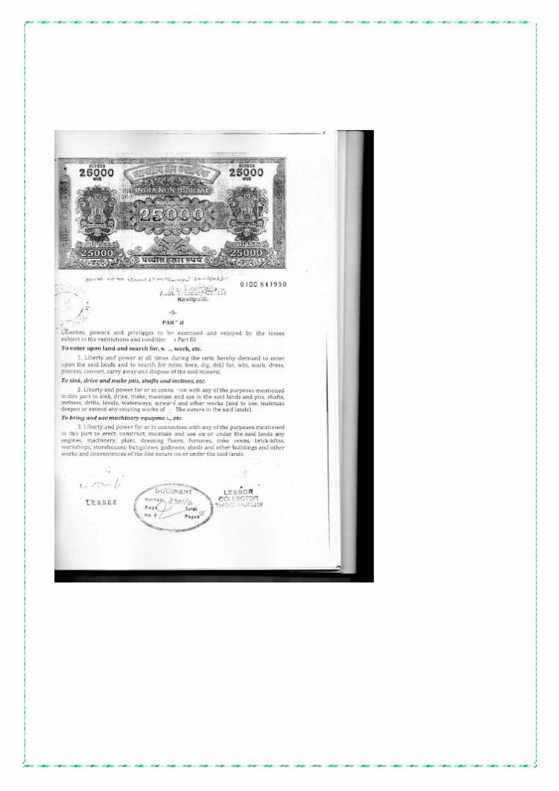
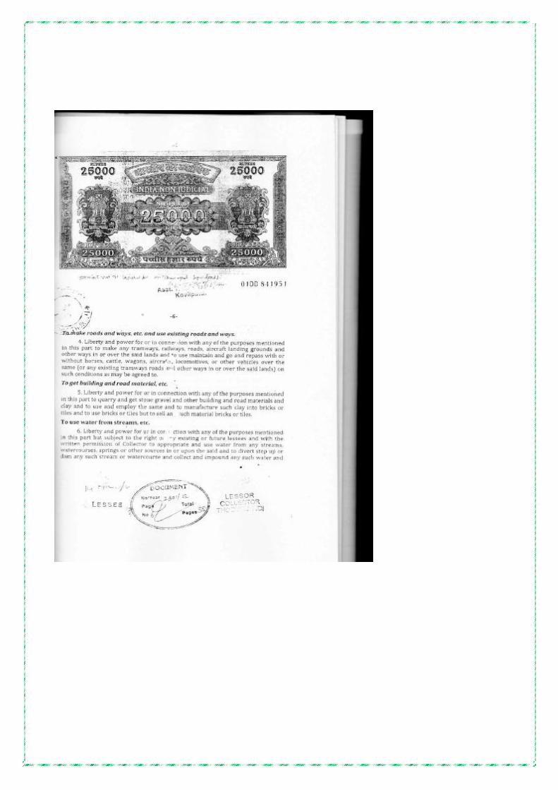


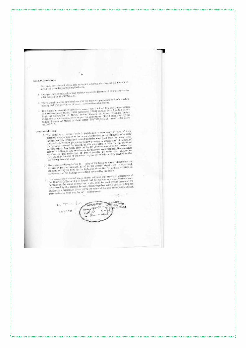


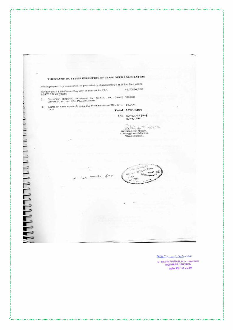


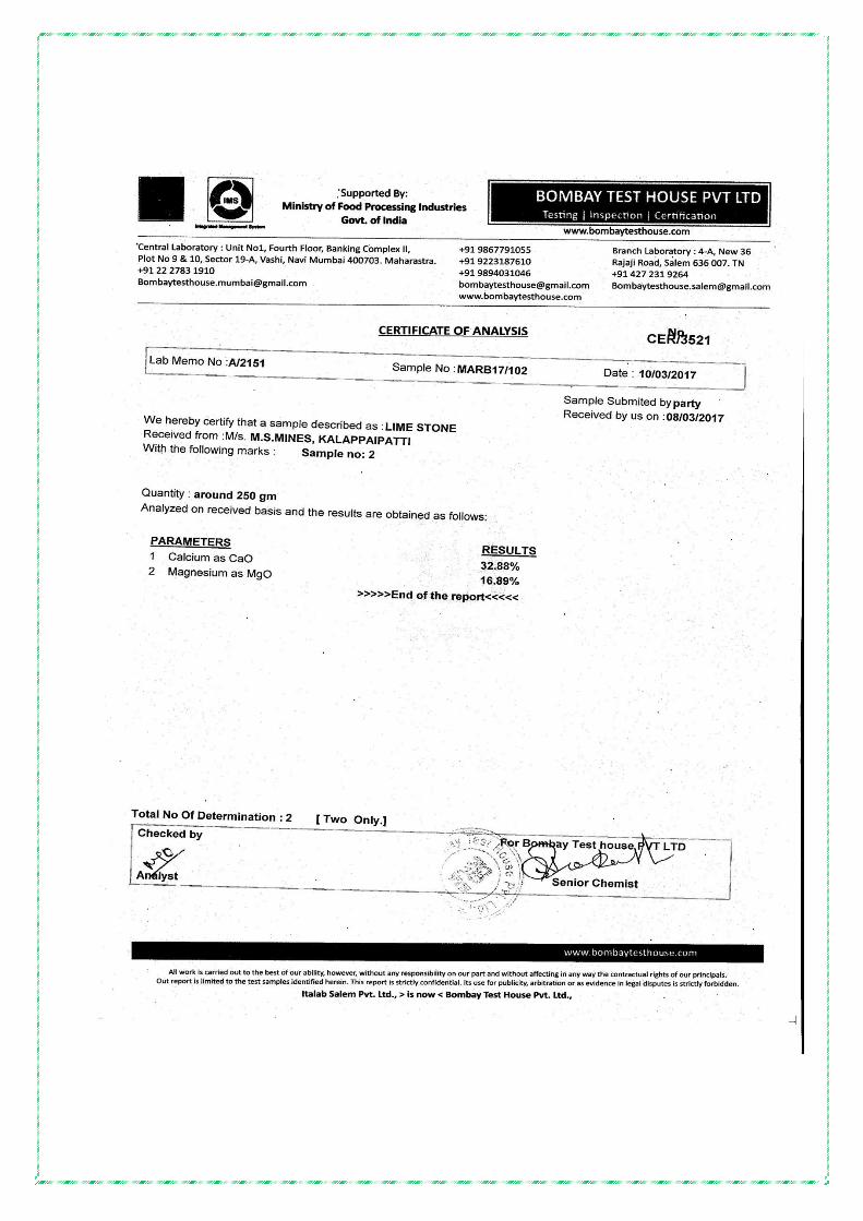


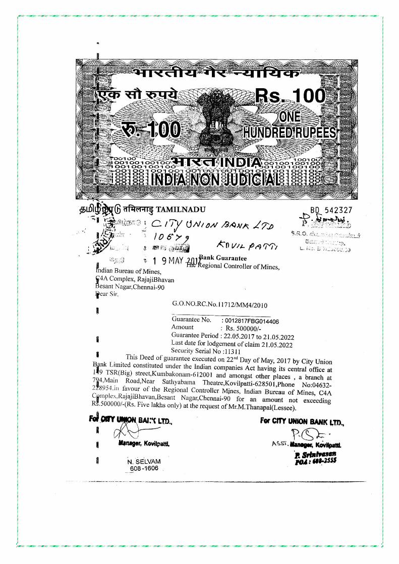


![Limestone, Chert, or Limestone? [2013225_fieldtrip]](https://img.pdfslide.net/doc/110x75/558421bfd8b42a86478b4731/limestone-chert-or-limestone-2013225fieldtrip.jpg)