Embed Size (px)
Citation preview
Page 1 of 9
12 June 2013, PERTH
Kango Iron Ore Project - Exploration Target
Emerging West Africa focussed iron ore company Volta Mining Limited (“Volta Mining”) (ASX: VTM) is pleased to to advise that a recently commissioned report “Kango Exploration Target Estimate”, dated May 2013 by SRK Consulting (Australasia) Pty Ltd and associates (Fathom Geophysics) (“SRK”) confirms that its Kango Iron Ore Project (the “Project”) in Gabon is prospective for itabirite mineralisation, with three (3) large scale magnetic anomalies identified within the licence area, interpreted to reflect favourable zones for iron mineralisation.
A full copy of SRK’s report “Kango Exploration Target Estimate”, dated May 2013, is available online for download. Please visit www.voltamining.com.au for more information.
Key Points » Kango Iron Ore Project prospective for itabirite-hosted iron mineralisation
» Historical drilling (2009) of 15 holes confirmed the presence of several itabirite zones
» Hematite enrichment of the itabirite recognised in some of the surface rock chip samples with grades ranging between 39% Fe and 61% Fe
» Three (3) large scale magnetic anomalies identified and interpreted to reflect favourable zones for iron mineralisation over a 40km strike length
» Kango Project lies approximately 25km from the multi-user Trans–Gabon Railway (“TGR”) and approximately 125km from the port of Owendo – Figure 1.
SRK considers the Kango Iron Ore Project to be early in the exploration cycle, however, limited drilling and surface sampling has confirmed the presence of itabirite in both magnetite and hematite enriched forms, with grades reported to range between 39% Fe and 61% Fe.
SRK’s estimate of the Exploration Target, based on several phases of unconstrained geophysical inversion modelling and geological interpretation, is 98Mt to 750Mt of material grading between 30% Fe to 45% Fe, with possible grades up to 60% Fe in places. It should be noted that the potential quality and grade of the Exploration Target is conceptual in nature, that there has been insufficient exploration to estimate a Mineral Resource, and it is uncertain if further exploration will result in the estimate of a Mineral Resource.
Managing Director of Volta Mining, David Sumich said, “The Exploration Target for our Kango Iron Ore Project presents another exciting opportunity for Volta Mining. The Project’s close proximity to major rail and port infrastructure is compelling and provides all necessary comfort to accelerate our exploration efforts. I am delighted that Volta Mining has two established iron ore plays in Gabon and we look forward to investigating their exploration, operating and infrastructure synergies.”

Page 2 of 9
Volta Mining Limited ASX VTM
ASX Announcement12 June 2013
Figure 1: Volta Mining’s Iron Ore Projects, Gabon: location and infrastructure
Exploration Target SRK’s estimates for the Exploration Target are based on several phases of unconstrained geophysical modelling and geological interpretations, with the understanding that the distribution of magnetic material may help define the distribution of iron rich zones within the Project area.
Geophysical inversions were conducted using variations of the traditional total magnetic intensity methods in order to counteract issues of remnant magnetism observed within the aeromagnetic data. An inversion process using the analytical signal was used (RTP VIAS), and an acceptable fit to the observed data was achieved. Isosurfaces reflecting the distribution of the magnetic material within the Project area were created for further interpretation.
Page 3 of 9
Volta Mining Limited ASX VTM
ASX Announcement12 June 2013
Additional geophysical image processing was conducted in order to highlight structural features with the Project area. Based on the inversion modelling, processed images and geological datasets, distribution of a potential iron rich geophysical unit was interpreted across a 40km strike length of the Kango licence. Three dimensional modelling of this unit was undertaken in order to define its lateral and subsurface extents, and to provide a geologically and geometrically realistic context to the magnetic anomaly.
A range of analysis considering the array of potential iron grades, thicknesses, unit tonnages and magnetic susceptibilities were tested in order to estimate the Exploration Target. A number of assumptions were required in order to undertake the range analysis in consideration of a geologically reasonable scenario for iron mineralisation. These were:
» Volumes were depth limited to 150m below surface, as this is considered a reasonable first-pass minable depth;
» The interpreted geophysical unit was assumed to host itabirite, with the interpreted mineralised volumes limited to this domain;
» This geophysical unit was assumed to only be mineralised within zones of elevated magnetic susceptibility (>0.04 SI); and
» Due to large variation of ranges for the magnetic inversion results, zones representing hematite enrichment could not be reasonably assessed.
Results of the range analysis are summarised below – Table 1.
Fe Grade (%) Tonnes (t) Unit Width (m) Magnetic Susceptibility (SI)
Min Case 30 98,000,000 5 0.07
Mid Case 45 750,000,000 15 0.06
Max Case 60 7000,000,000 40 0.04
Table 1: Summary of range analysis and resultant estimated Exploration Target ranges
Given the uncertainties associated with the geophysical modelling, SRK recommended that an Exploration Target for the Kango Iron Ore Project be considered at the lower end of the range; being 98Mt to 750Mt of material grading between 30% Fe to 45% Fe, with possible grades up to 60% Fe in places.
Exploration Work Completed Between 2009 and 2013 Core Mining Gabon SARL (“Core Mining”) identified a large magnetic anomaly extending over 40km along an ENE strike within the aeromagnetic datasets. Field work conducted by Core Mining as well as previous sampling by the Gabon Mines Department identified itabirite within the licence, with upgrading in some areas to hematite-itabirite. Several of these itabirite samples were found to correlate well with the identified anomalous magnetic zone.
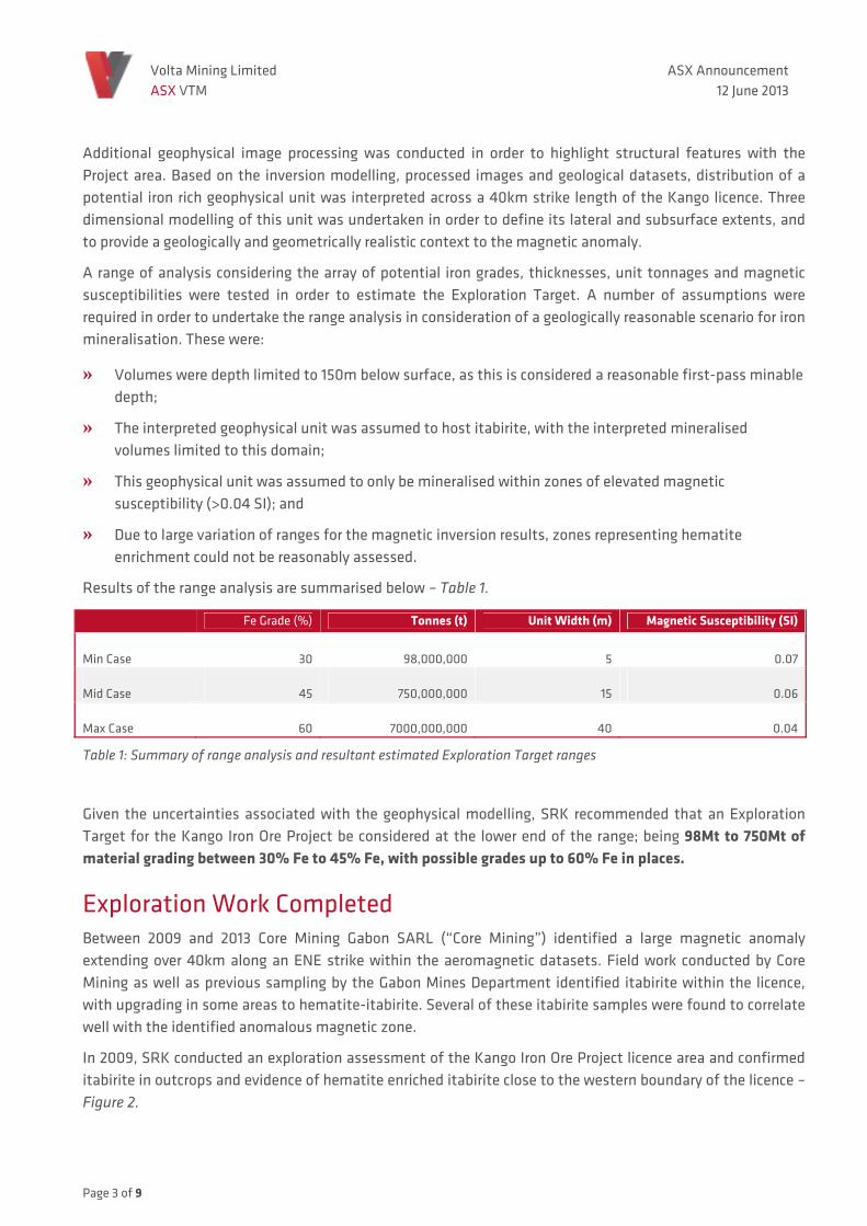
In 2009, SRK conducted an exploration assessment of the Kango Iron Ore Project licence area and confirmed itabirite in outcrops and evidence of hematite enriched itabirite close to the western boundary of the licence – Figure 2.
Page 4 of 9
Volta Mining Limited ASX VTM
ASX Announcement12 June 2013
Figure 2: Volta Mining’s Kango Iron Ore Project, Gabon - selected examples of hematite-enriched itabirite historically sampled (provided by Core Mining)
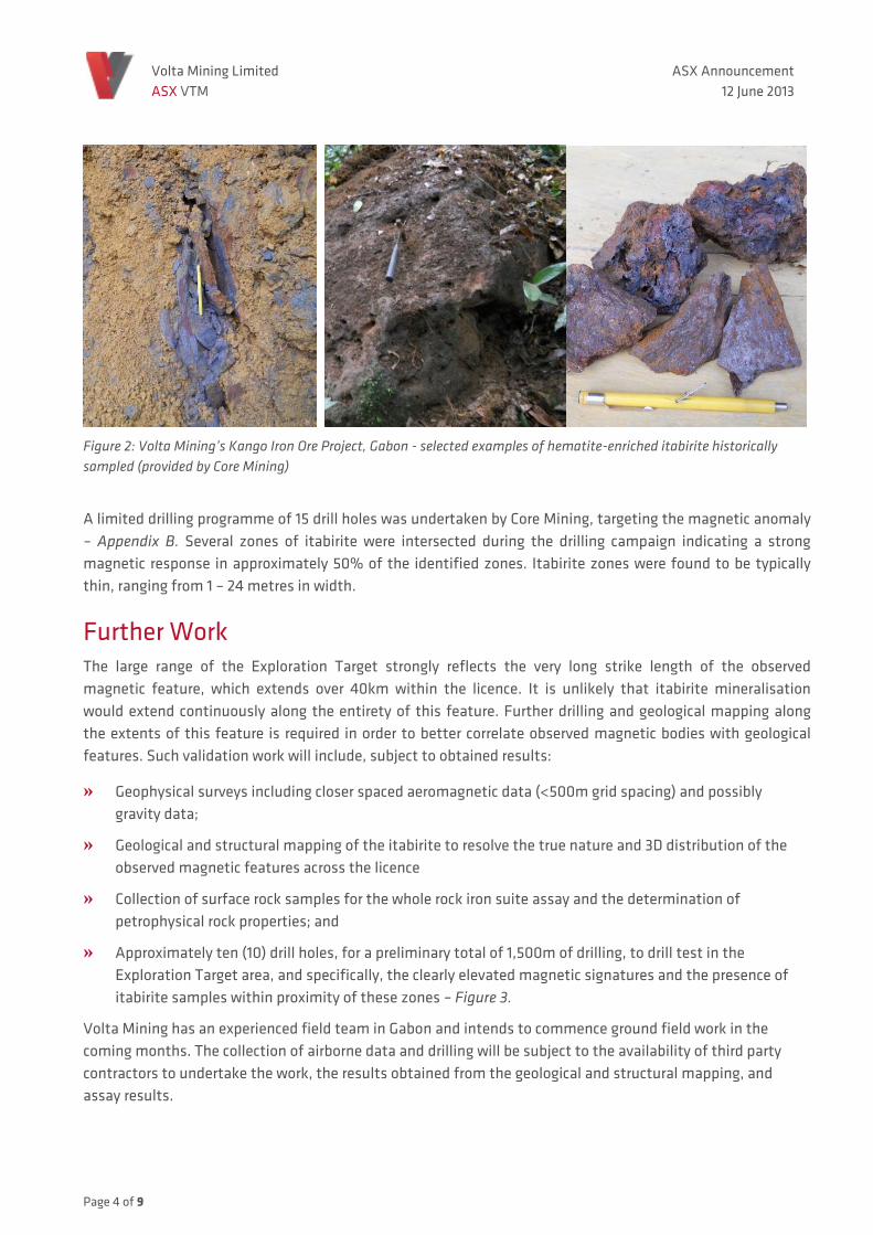
A limited drilling programme of 15 drill holes was undertaken by Core Mining, targeting the magnetic anomaly – Appendix B. Several zones of itabirite were intersected during the drilling campaign indicating a strong magnetic response in approximately 50% of the identified zones. Itabirite zones were found to be typically thin, ranging from 1 – 24 metres in width.
Further Work The large range of the Exploration Target strongly reflects the very long strike length of the observed magnetic feature, which extends over 40km within the licence. It is unlikely that itabirite mineralisation would extend continuously along the entirety of this feature. Further drilling and geological mapping along the extents of this feature is required in order to better correlate observed magnetic bodies with geological features. Such validation work will include, subject to obtained results:
» Geophysical surveys including closer spaced aeromagnetic data (<500m grid spacing) and possibly gravity data;
» Geological and structural mapping of the itabirite to resolve the true nature and 3D distribution of the observed magnetic features across the licence
» Collection of surface rock samples for the whole rock iron suite assay and the determination of petrophysical rock properties; and
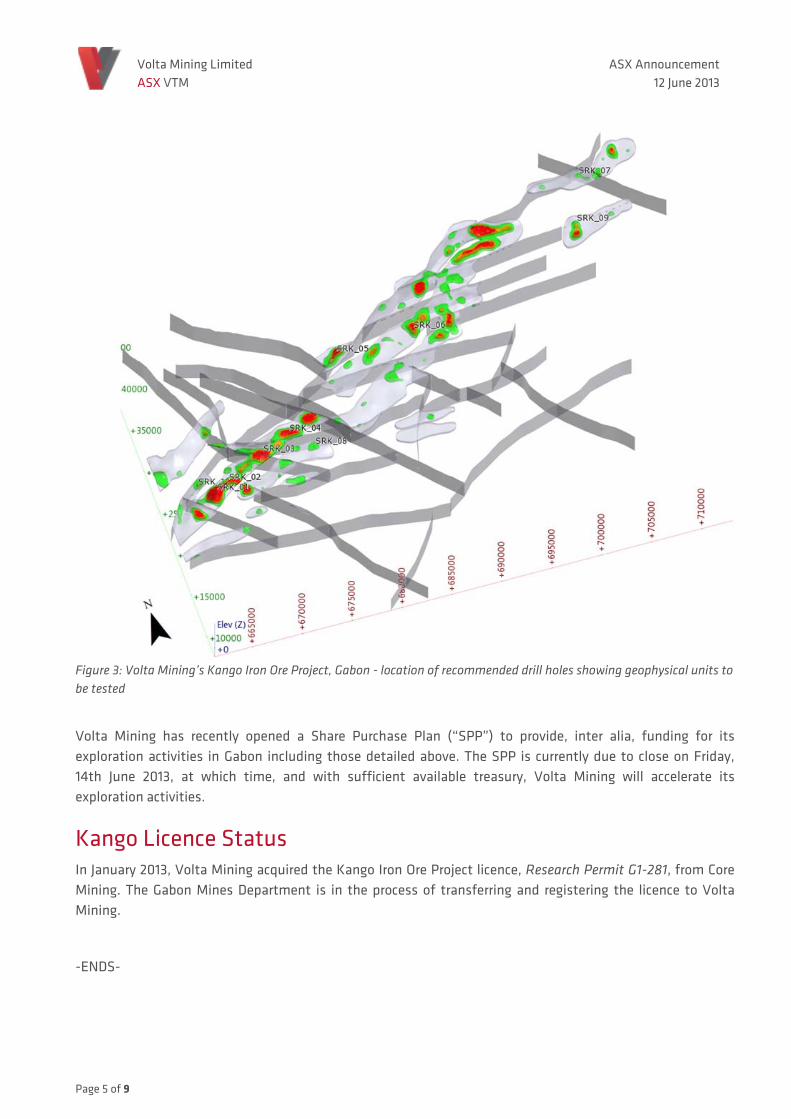
» Approximately ten (10) drill holes, for a preliminary total of 1,500m of drilling, to drill test in the Exploration Target area, and specifically, the clearly elevated magnetic signatures and the presence of itabirite samples within proximity of these zones – Figure 3.
Volta Mining has an experienced field team in Gabon and intends to commence ground field work in the coming months. The collection of airborne data and drilling will be subject to the availability of third party contractors to undertake the work, the results obtained from the geological and structural mapping, and assay results.
Page 5 of 9
Volta Mining Limited ASX VTM
ASX Announcement12 June 2013
Figure 3: Volta Mining’s Kango Iron Ore Project, Gabon - location of recommended drill holes showing geophysical units to be tested
Volta Mining has recently opened a Share Purchase Plan (“SPP”) to provide, inter alia, funding for its exploration activities in Gabon including those detailed above. The SPP is currently due to close on Friday, 14th June 2013, at which time, and with sufficient available treasury, Volta Mining will accelerate its exploration activities.
Kango Licence Status In January 2013, Volta Mining acquired the Kango Iron Ore Project licence, Research Permit G1-281, from Core Mining. The Gabon Mines Department is in the process of transferring and registering the licence to Volta Mining.
-ENDS-

Volta Mining Limited ASX VTM
ASX Announcement12 June 2013
For further information please contact:
Company Contact: Media Contact:
David Sumich Sarah Starick Managing Director Marketing Manager T +61 8 96212 3700 T +61 8 6212 3703 E [email protected] E [email protected]
About Volta Mining Limited Volta Mining Limited (ASX: VTM) is an emerging West Africa focussed iron ore company based in Perth, Australia with current interests in the acquisition, exploration and development of iron ore and gold assets. Its vision is to become a leading mid-cap resources company with advanced, sustainable projects in West Africa.
With a current landholding totalling 5,740km2, Volta Mining is one of the largest holders of prospective iron ore licences in West Africa; positioning it as a significant iron ore participant in the region*. The Mbombo Iron Ore Project in Gabon, Volta Mining’s primary focus, covers an area of 3,922km2 and lies adjacent to the world class Belinga iron ore deposit. It is synergistic in terms of operations, exploration and future infrastructure with Volta Mining’s recently acquired Kango Iron Ore Project covering a total area of 1,818km2 in Gabon*.
Volta Mining also has a portfolio of gold projects in Burkina Faso. The Koro, Ibi Palga and Dangue Gold Projects cover a combined area of 1,350.1km2.
Volta Mining listed on the ASX on 19 October 2011.
For more information please visit: www.voltamining.com.au *Upon Core’s transfer of the Kango exploration licence to Volta Mining’s Gabonese subsidiary Fer Mining under Ministerial approval as per the terms of the TSA. See ASX Announcement: “Volta Mining completes due diligence and agreements for its acquisition of the Kango Iron Ore Project”, dated 16 January 2013.
Competent person’s statement
The information in this Announcement that relates to Exploration Targets or Exploration Results is based on information compiled by Dr Louis Bucci, as provided by Volta Mining Ltd. Dr Bucci is a full time employee of SRK Consulting (Australasia) Pty Ltd, and a Member of the Australian Institute of Geoscientists. Dr Bucci has sufficient experience which is relevant to the activity being undertaken to qualify as a Competent Person as defined in the 2012 edition of the “Australasian Code for Reporting of Exploration Results, Minerals Resources and Ore Reserves.” Dr Bucci has consented to the inclusion of this information in the form and context in which it appears in this report.
Volta Mining Limited ASX VTM
ASX Announcement12 June 2013
Appendix A: SRK Consulting JORC Code 2012 Edition Table 1 (see following page)

SRK Consulting Appendix A
JORC Code, 2012 Edition – Table 1 report template Section 1 Sampling Techniques and Data
(Criteria in this section apply to all succeeding sections.)
Criteria JORC Code explanation Commentary
Sampling techniques
• Nature and quality of sampling (e.g. cut channels, random chips, or specific specialised industry standard measurement tools appropriate to the minerals under investigation, such as downhole gamma sondes, or handheld XRF instruments, etc.). These examples should not be taken as limiting the broad meaning of sampling.
• Include reference to measures taken to ensure sample representivity and the appropriate calibration of any measurement tools or systems used.
• Aspects of the determination of mineralisation that are Material to the Public Report.
• In cases where ‘industry standard’ work has been done, this would be relatively simple (e.g. ‘reverse circulation drilling was used to obtain 1 m samples from which 3 kg was pulverised to produce a 30 g charge for fire assay’). In other cases, more explanation may be required, such as where there is coarse gold that has inherent sampling problems. Unusual commodities or mineralisation types (e.g. submarine nodules) may warrant disclosure of detailed information.
• Sampling information is from historical exploration conducted by Core Mining. Sampling technique information was not available during the course of this study;
• Information not available;
• Itabirite identified in surface rock chip samples and drill core;
Drilling techniques
• Drill type (e.g. core, reverse circulation, open-hole hammer, rotary air blast, auger, Bangka, sonic, etc.) and details (e.g. core diameter, triple or standard tube, depth of diamond tails, face-sampling bit or other type, whether core is oriented and if so, by what method, etc.).
• Historical diamond core drilling was conducted by Core Mining. The specifics of the drilling campaign were not available. Core type was diamond.
Drill sample recovery
• Method of recording and assessing core and chip sample recoveries and results assessed.
• Measures taken to maximise sample recovery and ensure representative nature of the samples.
• Whether a relationship exists between sample recovery and grade and whether sample bias may have occurred due to preferential loss/gain of fine/coarse material.
• Drilling conducted is historical. Field notes and geological logs recorded in paper format then entered into spread sheets.
• No details provided
Logging • Whether core and chip samples have been geologically and geotechnically logged to a level of detail to support appropriate
• Diamond core was geologically logged defining key geological units. No core photos were taken or geotechnical information logged.
JUPP\BUCC\thoj VOL001_SRKJORC Code 2012 - Table 1_rev0.docx 11 June 2013
SRK Consulting Appendix A
Criteria JORC Code explanation Commentary
Mineral Resource estimation, mining studies and metallurgical studies.
• Whether logging is qualitative or quantitative in nature. Core (or costean, channel, etc.) photography.
• The total length and percentage of the relevant intersections logged.
• Logging was qualitative. No core photos were taken • Total length of drilled and logged core was 895.5m of which 175.89m was
logged as itabirite totaling 19% of observed core.
Sub-sampling techniques and sample preparation
• If core, whether cut or sawn and whether quarter, half or all core taken.
• If non-core, whether riffled, tube sampled, rotary split, etc. and whether sampled wet or dry.
• For all sample types, the nature, quality and appropriateness of the sample preparation technique.
• Quality control procedures adopted for all sub-sampling stages to maximise representivity of samples.
• Measures taken to ensure that the sampling is representative of the in situ material collected, including for instance results for field duplicate/second-half sampling.
• Whether sample sizes are appropriate to the grain size of the material being sampled.
• Information for sampling techniques for historical drilling was not available; • Information for historical surface sampling assay techniques was not available; • Information for historical surface sampling assay techniques was not available; • Information for historical surface sampling assay techniques was not available; • Information for historical surface sampling assay techniques was not available; • Information for historical surface sampling assay techniques was not available
Quality of assay data and laboratory tests
• The nature, quality and appropriateness of the assaying and laboratory procedures used and whether the technique is considered partial or total.
• For geophysical tools, spectrometers, handheld XRF instruments, etc., the parameters used in determining the analysis including instrument make and model, reading times, calibrations factors applied and their derivation, etc.
• Nature of quality control procedures adopted (e.g. standards, blanks, duplicates, external laboratory checks) and whether acceptable levels of accuracy (i.e. lack of bias) and precision have been established.
• Information for sampling techniques for historical drilling was not available • Information for historical surface sampling assay techniques was not available • Information for historical surface sampling assay techniques was not available
Verification of sampling and assaying
• The verification of significant intersections by either independent or alternative company personnel.
• The use of twinned holes. • Documentation of primary data, data entry procedures, data
verification, data storage (physical and electronic) protocols. • Discuss any adjustment to assay data.
• Information for sampling techniques for historical drilling was not available • Information for historical surface sampling techniques was not available. • Hand logs entered into spreadsheets. Unclear on storage of original logs;
• N/A
Location of data points
• Accuracy and quality of surveys used to locate drill holes (collar and down-hole surveys), trenches, mine workings and other
• Historical diamond drilling and surface rock sample locations are in coordinate system UTM32N. No elevation location control values were recorded in
JUPP\BUCC\thoj VOL001_SRKJORC Code 2012 - Table 1_rev0.docx 11 June 2013
SRK Consulting Appendix A
Criteria JORC Code explanation Commentary
locations used in Mineral Resource estimation. • Specification of the grid system used. • Quality and adequacy of topographic control.
available data. Down holes surveys were recorded • Coordinate system UTM32N
• Information for technique applied in locating historical surface sampling locations was not available.
Data spacing and distribution
• Data spacing for reporting of Exploration Results. • Whether the data spacing and distribution is sufficient to
establish the degree of geological and grade continuity appropriate for the Mineral Resource and Ore Reserve estimation procedure(s) and classifications applied.
• Whether sample compositing has been applied.
• Variably spaced surface rock chip samples as presented in Figure 1. Drill holes were irregularly spaced as presented in Figure 1. Geophgysics was flown at a 500m line spacing
• No Mineral Resource estimated;
• N/A
Orientation of data in relation to geological structure
• Whether the orientation of sampling achieves unbiased sampling of possible structures and the extent to which this is known, considering the deposit type.
• If the relationship between the drilling orientation and the orientation of key mineralised structures is considered to have introduced a sampling bias, this should be assessed and reported if material.
• Information for sampling techniques for historical drilling was not available;
• Information for sampling techniques for historical drilling was not available
Sample security
• The measures taken to ensure sample security. • Sampling techniques and security information for historical drilling and surface rock samples was not available
Audits or reviews
• The results of any audits or reviews of sampling techniques and data.
• Information for sampling techniques and of any audits were conducted for historical drilling and surface rock sampling was not available
JUPP\BUCC\thoj VOL001_SRKJORC Code 2012 - Table 1_rev0.docx 11 June 2013
SRK Consulting Appendix A
Section 2 Reporting of Exploration Results
(Criteria listed in section 1 also apply to this section.)
Criteria JORC Code explanation Commentary
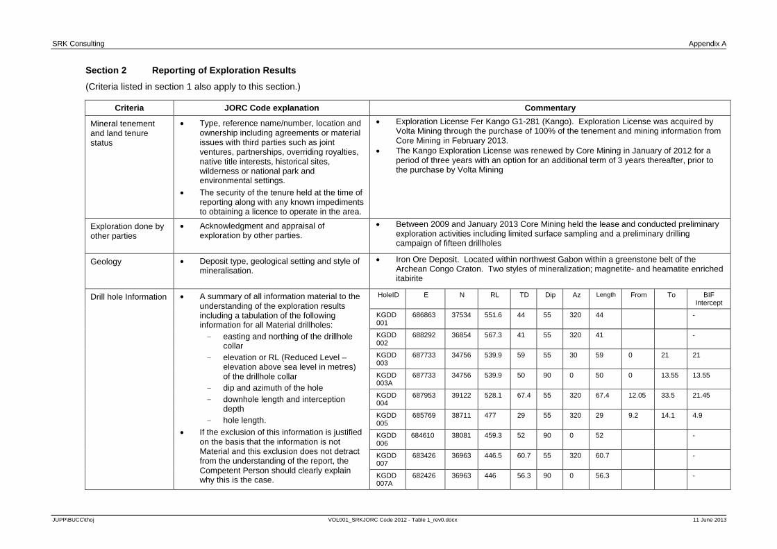
Mineral tenement and land tenure status
• Type, reference name/number, location and ownership including agreements or material issues with third parties such as joint ventures, partnerships, overriding royalties, native title interests, historical sites, wilderness or national park and environmental settings.
• The security of the tenure held at the time of reporting along with any known impediments to obtaining a licence to operate in the area.
• Exploration License Fer Kango G1-281 (Kango). Exploration License was acquired by Volta Mining through the purchase of 100% of the tenement and mining information from Core Mining in February 2013.
• The Kango Exploration License was renewed by Core Mining in January of 2012 for a period of three years with an option for an additional term of 3 years thereafter, prior to the purchase by Volta Mining
Exploration done by other parties
• Acknowledgment and appraisal of exploration by other parties.
• Between 2009 and January 2013 Core Mining held the lease and conducted preliminary exploration activities including limited surface sampling and a preliminary drilling campaign of fifteen drillholes
Geology • Deposit type, geological setting and style of mineralisation.
• Iron Ore Deposit. Located within northwest Gabon within a greenstone belt of the Archean Congo Craton. Two styles of mineralization; magnetite- and heamatite enriched itabirite
Drill hole Information • A summary of all information material to the understanding of the exploration results including a tabulation of the following information for all Material drillholes: - easting and northing of the drillhole
collar - elevation or RL (Reduced Level –
elevation above sea level in metres) of the drillhole collar
- dip and azimuth of the hole - downhole length and interception
depth - hole length.
• If the exclusion of this information is justified on the basis that the information is not Material and this exclusion does not detract from the understanding of the report, the Competent Person should clearly explain why this is the case.
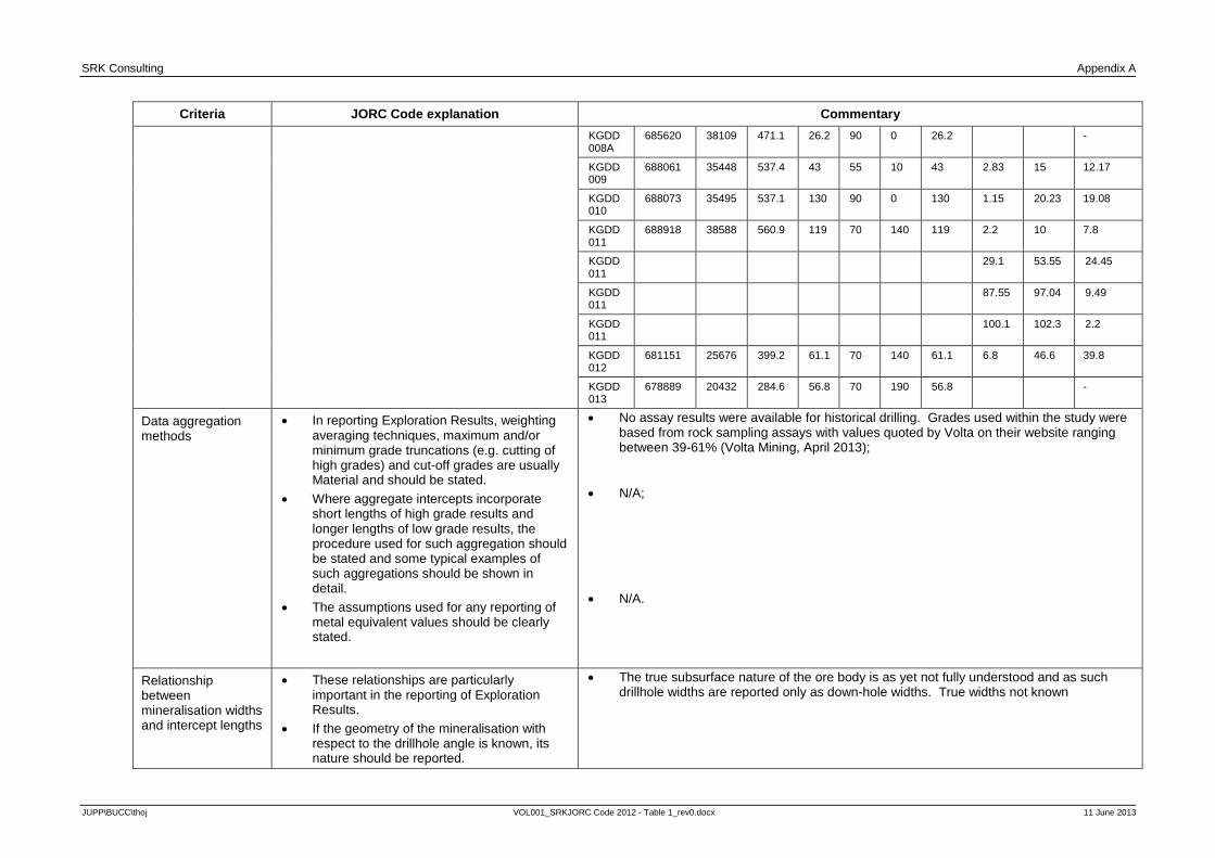
HoleID E N RL TD Dip Az Length From To BIF Intercept
KGDD 001
686863 37534 551.6 44 55 320 44 -
KGDD 002
688292 36854 567.3 41 55 320 41 -
KGDD 003
687733 34756 539.9 59 55 30 59 0 21 21
KGDD 003A
687733 34756 539.9 50 90 0 50 0 13.55 13.55
KGDD 004
687953 39122 528.1 67.4 55 320 67.4 12.05 33.5 21.45
KGDD 005
685769 38711 477 29 55 320 29 9.2 14.1 4.9
KGDD 006
684610 38081 459.3 52 90 0 52 -
KGDD 007
683426 36963 446.5 60.7 55 320 60.7 -
KGDD 007A
682426 36963 446 56.3 90 0 56.3 -
JUPP\BUCC\thoj VOL001_SRKJORC Code 2012 - Table 1_rev0.docx 11 June 2013
SRK Consulting Appendix A
Criteria JORC Code explanation Commentary
KGDD 008A
685620 38109 471.1 26.2 90 0 26.2 -
KGDD 009
688061 35448 537.4 43 55 10 43 2.83 15 12.17
KGDD 010
688073 35495 537.1 130 90 0 130 1.15 20.23 19.08
KGDD 011
688918 38588 560.9 119 70 140 119 2.2 10 7.8
KGDD 011
29.1 53.55 24.45
KGDD 011
87.55 97.04 9.49
KGDD 011
100.1 102.3 2.2
KGDD 012
681151 25676 399.2 61.1 70 140 61.1 6.8 46.6 39.8
KGDD 013
678889 20432 284.6 56.8 70 190 56.8 -
Data aggregation methods
• In reporting Exploration Results, weighting averaging techniques, maximum and/or minimum grade truncations (e.g. cutting of high grades) and cut-off grades are usually Material and should be stated.
• Where aggregate intercepts incorporate short lengths of high grade results and longer lengths of low grade results, the procedure used for such aggregation should be stated and some typical examples of such aggregations should be shown in detail.
• The assumptions used for any reporting of metal equivalent values should be clearly stated.
• No assay results were available for historical drilling. Grades used within the study were based from rock sampling assays with values quoted by Volta on their website ranging between 39-61% (Volta Mining, April 2013);
• N/A; • N/A.
Relationship between mineralisation widths and intercept lengths
• These relationships are particularly important in the reporting of Exploration Results.
• If the geometry of the mineralisation with respect to the drillhole angle is known, its nature should be reported.
• The true subsurface nature of the ore body is as yet not fully understood and as such drillhole widths are reported only as down-hole widths. True widths not known
JUPP\BUCC\thoj VOL001_SRKJORC Code 2012 - Table 1_rev0.docx 11 June 2013

SRK Consulting Appendix A
Criteria JORC Code explanation Commentary
• If it is not known and only the downhole lengths are reported, there should be a clear statement to this effect (e.g. ‘down hole length, true width not known’).
Diagrams • Appropriate maps and sections (with scales) and tabulations of intercepts should be included for any significant discovery being reported These should include, but not be limited to a plan view of drillhole collar locations and appropriate sectional views.
• Figure 1: Locations of Surface Samples and Drill Holes Collars within Kango Project • Refer to SRK (2013) for additional spacial data
Balanced reporting • Where comprehensive reporting of all Exploration Results is not practicable, representative reporting of both low and high grades and/or widths should be practiced to avoid misleading reporting of Exploration Results.
• Full list of surface exploration results presented in SRK (2013)
Other substantive exploration data
• Other exploration data, if meaningful and material, should be reported including (but not limited to): geological observations; geophysical survey results; geochemical survey results; bulk samples – size and method of treatment; metallurgical test
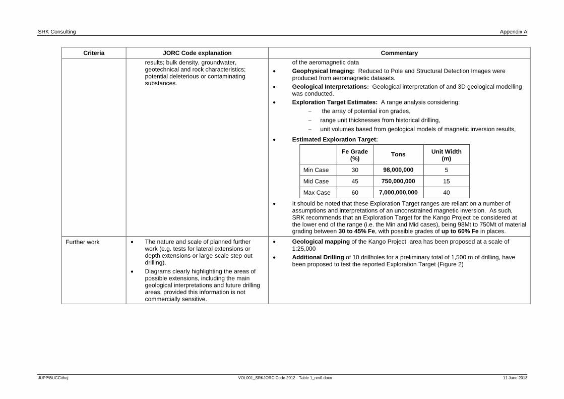
• Several phases of geophysical modeling and geological interpretation of aeromagnetic data were conducted in order to define an Exploration Target for the Kango Project. Details are outlined in detail within the SRK (2013) and outlined as follows:
• Magnetic Data: Aeromagnetic data was collected as part of a regional survey over the Kango Project with a line spacing of 500m
• Magnetic Inversions: Unconstrained 3D magnetic inversion modelling was conducted
JUPP\BUCC\thoj VOL001_SRKJORC Code 2012 - Table 1_rev0.docx 11 June 2013
SRK Consulting Appendix A
Criteria JORC Code explanation Commentary
results; bulk density, groundwater, geotechnical and rock characteristics; potential deleterious or contaminating substances.
of the aeromagnetic data • Geophysical Imaging: Reduced to Pole and Structural Detection Images were
produced from aeromagnetic datasets. • Geological Interpretations: Geological interpretation of and 3D geological modelling
was conducted. • Exploration Target Estimates: A range analysis considering:
− the array of potential iron grades, − range unit thicknesses from historical drilling, − unit volumes based from geological models of magnetic inversion results,
• Estimated Exploration Target:
Fe Grade
(%) Tons Unit Width
(m)
Min Case 30 98,000,000 5
Mid Case 45 750,000,000 15
Max Case 60 7,000,000,000 40
• It should be noted that these Exploration Target ranges are reliant on a number of assumptions and interpretations of an unconstrained magnetic inversion. As such, SRK recommends that an Exploration Target for the Kango Project be considered at the lower end of the range (i.e. the Min and Mid cases), being 98Mt to 750Mt of material grading between 30 to 45% Fe, with possible grades of up to 60% Fe in places.
Further work • The nature and scale of planned further work (e.g. tests for lateral extensions or depth extensions or large-scale step-out drilling).
• Diagrams clearly highlighting the areas of possible extensions, including the main geological interpretations and future drilling areas, provided this information is not commercially sensitive.
• Geological mapping of the Kango Project area has been proposed at a scale of 1:25,000
• Additional Drilling of 10 drillholes for a preliminary total of 1,500 m of drilling, have been proposed to test the reported Exploration Target (Figure 2)
JUPP\BUCC\thoj VOL001_SRKJORC Code 2012 - Table 1_rev0.docx 11 June 2013

SRK Consulting Appendix A
Criteria JORC Code explanation Commentary
• Figure 2: Recommended drill hole locations
JUPP\BUCC\thoj VOL001_SRKJORC Code 2012 - Table 1_rev0.docx 11 June 2013
Volta Mining Limited ASX VTM
ASX Announcement12 June 2013
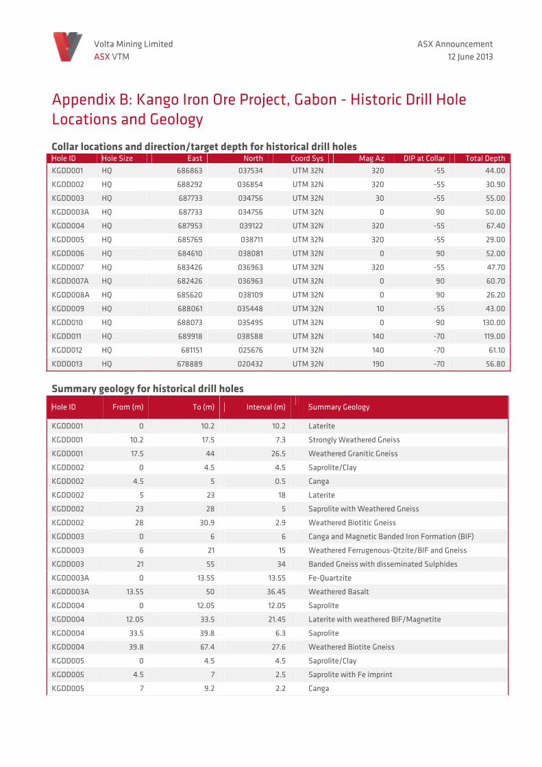
Appendix B: Kango Iron Ore Project, Gabon - Historic Drill Hole Locations and Geology
Collar locations and direction/target depth for historical drill holes Hole ID Hole Size East North Coord Sys Mag Az DIP at Collar Total DepthKGDD001 HQ 686863 037534 UTM 32N 320 -55 44.00
KGDD002 HQ 688292 036854 UTM 32N 320 -55 30.90
KGDD003 HQ 687733 034756 UTM 32N 30 -55 55.00
KGDD003A HQ 687733 034756 UTM 32N 0 90 50.00
KGDD004 HQ 687953 039122 UTM 32N 320 -55 67.40
KGDD005 HQ 685769 038711 UTM 32N 320 -55 29.00
KGDD006 HQ 684610 038081 UTM 32N 0 90 52.00
KGDD007 HQ 683426 036963 UTM 32N 320 -55 47.70
KGDD007A HQ 682426 036963 UTM 32N 0 90 60.70
KGDD008A HQ 685620 038109 UTM 32N 0 90 26.20
KGDD009 HQ 688061 035448 UTM 32N 10 -55 43.00
KGDD010 HQ 688073 035495 UTM 32N 0 90 130.00
KGDD011 HQ 689918 038588 UTM 32N 140 -70 119.00
KGDD012 HQ 681151 025676 UTM 32N 140 -70 61.10
KDDD013 HQ 678889 020432 UTM 32N 190 -70 56.80
Summary geology for historical drill holes Hole ID From (m) To (m) Interval (m)
Summary Geology
KGDD001 0 10.2 10.2 Laterite
KGDD001 10.2 17.5 7.3 Strongly Weathered Gneiss
KGDD001 17.5 44 26.5 Weathered Granitic Gneiss
KGDD002 0 4.5 4.5 Saprolite/Clay
KGDD002 4.5 5 0.5 Canga
KGDD002 5 23 18 Laterite
KGDD002 23 28 5 Saprolite with Weathered Gneiss
KGDD002 28 30.9 2.9 Weathered Biotitic Gneiss
KGDD003 0 6 6 Canga and Magnetic Banded Iron Formation (BIF)
KGDD003 6 21 15 Weathered Ferrugenous-Qtzite/BIF and Gneiss
KGDD003 21 55 34 Banded Gneiss with disseminated Sulphides
KGDD003A 0 13.55 13.55 Fe-Quartzite
KGDD003A 13.55 50 36.45 Weathered Basalt
KGDD004 0 12.05 12.05 Saprolite
KGDD004 12.05 33.5 21.45 Laterite with weathered BIF/Magnetite
KGDD004 33.5 39.8 6.3 Saprolite
KGDD004 39.8 67.4 27.6 Weathered Biotite Gneiss
KGDD005 0 4.5 4.5 Saprolite/Clay
KGDD005 4.5 7 2.5 Saprolite with Fe imprint
KGDD005 7 9.2 2.2 Canga
Volta Mining Limited ASX VTM
ASX Announcement12 June 2013
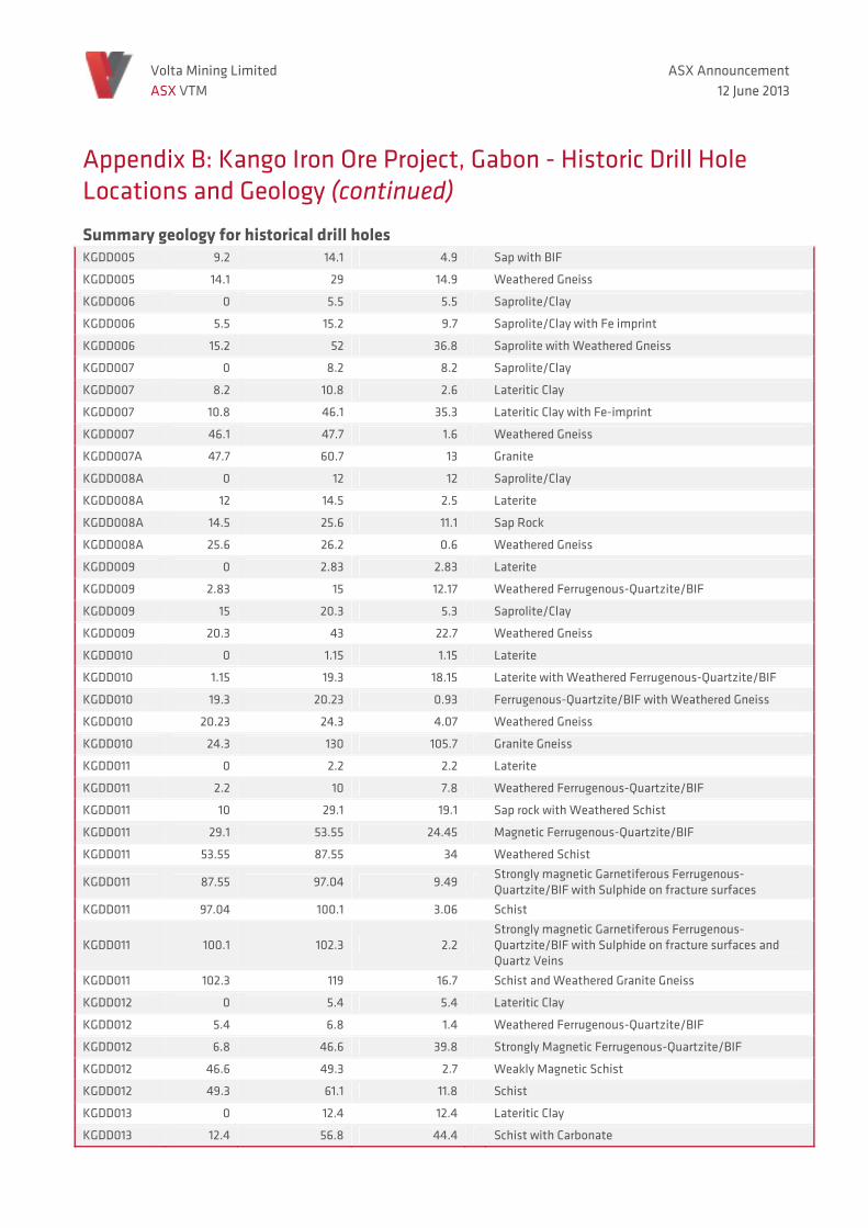
Appendix B: Kango Iron Ore Project, Gabon - Historic Drill Hole Locations and Geology (continued)
Summary geology for historical drill holes KGDD005 9.2 14.1 4.9 Sap with BIF
KGDD005 14.1 29 14.9 Weathered Gneiss
KGDD006 0 5.5 5.5 Saprolite/Clay
KGDD006 5.5 15.2 9.7 Saprolite/Clay with Fe imprint
KGDD006 15.2 52 36.8 Saprolite with Weathered Gneiss
KGDD007 0 8.2 8.2 Saprolite/Clay
KGDD007 8.2 10.8 2.6 Lateritic Clay
KGDD007 10.8 46.1 35.3 Lateritic Clay with Fe-imprint
KGDD007 46.1 47.7 1.6 Weathered Gneiss
KGDD007A 47.7 60.7 13 Granite
KGDD008A 0 12 12 Saprolite/Clay
KGDD008A 12 14.5 2.5 Laterite
KGDD008A 14.5 25.6 11.1 Sap Rock
KGDD008A 25.6 26.2 0.6 Weathered Gneiss
KGDD009 0 2.83 2.83 Laterite
KGDD009 2.83 15 12.17 Weathered Ferrugenous-Quartzite/BIF
KGDD009 15 20.3 5.3 Saprolite/Clay
KGDD009 20.3 43 22.7 Weathered Gneiss
KGDD010 0 1.15 1.15 Laterite
KGDD010 1.15 19.3 18.15 Laterite with Weathered Ferrugenous-Quartzite/BIF
KGDD010 19.3 20.23 0.93 Ferrugenous-Quartzite/BIF with Weathered Gneiss
KGDD010 20.23 24.3 4.07 Weathered Gneiss
KGDD010 24.3 130 105.7 Granite Gneiss
KGDD011 0 2.2 2.2 Laterite
KGDD011 2.2 10 7.8 Weathered Ferrugenous-Quartzite/BIF
KGDD011 10 29.1 19.1 Sap rock with Weathered Schist
KGDD011 29.1 53.55 24.45 Magnetic Ferrugenous-Quartzite/BIF
KGDD011 53.55 87.55 34 Weathered Schist
KGDD011 87.55 97.04 9.49 Strongly magnetic Garnetiferous Ferrugenous-Quartzite/BIF with Sulphide on fracture surfaces
KGDD011 97.04 100.1 3.06 Schist
KGDD011 100.1 102.3 2.2 Strongly magnetic Garnetiferous Ferrugenous-Quartzite/BIF with Sulphide on fracture surfaces and Quartz Veins
KGDD011 102.3 119 16.7 Schist and Weathered Granite Gneiss
KGDD012 0 5.4 5.4 Lateritic Clay
KGDD012 5.4 6.8 1.4 Weathered Ferrugenous-Quartzite/BIF
KGDD012 6.8 46.6 39.8 Strongly Magnetic Ferrugenous-Quartzite/BIF
KGDD012 46.6 49.3 2.7 Weakly Magnetic Schist
KGDD012 49.3 61.1 11.8 Schist
KGDD013 0 12.4 12.4 Lateritic Clay
KGDD013 12.4 56.8 44.4 Schist with Carbonate