Embed Size (px)
Citation preview
1
KansasNG911GeographicInformationSystemGovernancePolicy
InitialRelease March6,2015LastRevised March6,2015Preparedby KenNelsonandGISSubcommitteePreparedfor ScottEkberg

2
DocumentChangeRecord
Date Author Purpose
3
Contents1 Introduction.........................................................................................................................................5
2 ScopeandPurpose...............................................................................................................................5
3 ApplicableDocuments..........................................................................................................................5
3.1 NationalStandardsandDocuments.............................................................................................6
3.2 StateStandardsandDocuments..................................................................................................6
4 GISSystemGovernance.......................................................................................................................6
5 GISGovernanceOrganization..............................................................................................................7
5.1 CouncilStandingCommittees......................................................................................................7
5.2 GISSubcommittee........................................................................................................................7
5.3 GISRegions...................................................................................................................................7
5.4 ParliamentaryPractice.................................................................................................................8
5.5 Policy............................................................................................................................................8
5.6 GISGovernancePolicyAmendment.............................................................................................8
6 GISStrategicPlan.................................................................................................................................8
7 GISOperationsWorkPlan....................................................................................................................9
8 GISDataStandardsandRemediationGuidelines.................................................................................9
9 CommunicationPlan............................................................................................................................9
10 TrainingPlan.....................................................................................................................................9
11 PublicRelationsPlan......................................................................................................................10
12 ChangeManagementPlan.............................................................................................................10
13 SecurityPlan...................................................................................................................................11
14 Reports...........................................................................................................................................11
15 GISBudget......................................................................................................................................11
16 GISCalendar...................................................................................................................................11
17 StakeholderCompliance.................................................................................................................12
17.1 LocalDataStewards...................................................................................................................12
17.1.1 Definition............................................................................................................................12
17.1.2 LocalDataStewardCertification........................................................................................12
17.1.3 Contacts..............................................................................................................................12
17.1.4 DataMaintenance..............................................................................................................12
17.1.5 SubmissiontoGISMasterRepository................................................................................13
17.2 DataMaintainers........................................................................................................................13
4
17.2.1 Definition............................................................................................................................13
17.2.2 LocalGISDataMaintenanceStaff......................................................................................13
17.2.3 GISVendorscontractedforlocaldatamaintenance..........................................................13
17.3 DataConsumers.........................................................................................................................13
17.3.1 Definition............................................................................................................................13
17.3.2 ApprovedUse.....................................................................................................................13
17.3.3 DataRequests.....................................................................................................................13
17.4 ProgramContributors.................................................................................................................14
17.5 ProgramSupporters...................................................................................................................14
TablesTable1GISActivities..................................................................................................................................11Table2GISStakeholders............................................................................................................................14
5
1 IntroductionTheGeographicInformationSystem(GIS)andassociatedstatewidedatalayersarethecornerstoneofaNextGeneration911(NG911)system.Geographicdata,includingaddresspoints,roadcenterlines,andemergencyserviceboundaries,willbedevelopedandlocallymaintainedandaggregatedintoastatewidegeodatabase.AlllocationinformationrequiredtosupportNG911callroutingwillbederivedfromthestatewidegeodatabase;thereforeitisvitalthatthisinformationisaccurate,authoritative,standardized,current,andhighlyavailable.PoliciesshallbedevelopedtogovernallaspectsoftheGISsystem(people,processes,data,andsystems)andenforceconsistencyinhowstandardsareappliedacrossjurisdictions.Additionally,changemanagementproceduresmustbefollowedtoensureeffectivesystemmanagement.AccurateGISdataisrequiredtopowerNG911.Withoutit,NG911willfail.
2 ScopeandPurposeThepurposeofthisGISGovernancePolicyistoarticulatethedetailsforGISdatamanagementasitrelatestoandsupportsourstatewideNG911GovernancePolicy.ToensurethesafetyofKansans,theintegrityofourNG911systemcannotbecompromised.Toaccomplishthisobjective,theGISSubcommitteeandtheGISStakeholdersmustworktogethertodevelopandadopttheessentialpoliciesandaccountabilitythatgoverntheGISportionofKansasNG911.
Thebodyofthisdocumenthastwomainsections:PolicyandCompliance.TheGISSubcommitteeassumesaleadershiprolefordevelopingandmaintainingGISdatapolicies.TheGISDataStakeholdersensuretheintegrityofNG911throughcompliancewiththosepolices.
Thisdocumentdefinestheroles,responsibilities,organization,structureandmethodsforestablishingGISpolicyandassuringcompliancewiththatpolicy.
UnlikeBasic911andE911,NG911isstateregulated,whileallowingPSAPsthegreatestlatitudeandfreedomwithoutcompromisingtheintegrityoftheNG911systemorcitizensafetyofKansas.
ThisGISGovernancePolicyisintendedtoaddressthetechnicalaspectsofNG911thatdependonlocaljurisdictionsupportinordertoensurethatintegrity.TheTechnicalPolicyStructureforKansasisshowninFigure1.
ThefollowingArticlesandSectionsherebyestablishandaffirmthegovernanceofKansasGISDataasrelatedtoNG911.
3 ApplicableDocumentsa. TheGISSubcommitteeisresponsibleformonitoringandadvisingtheKansas911Coordinating
CouncilofallexistingandemergingnationalstandardsrelevanttoNG911.Forexample,NG911standardsandspecificationsdevelopedandreleasedbytheFederalCommunicationsCommission(FCC)andNationalEmergencyNumberAssociation(NENA).
b. Intheeventofconflictamongourvarioussupportingdocuments:1. TheKansaslegislativestatute(s)takeprecedenceovertheNG911GovernancePolicy2. TheNG911GovernancePolicytakesprecedenceoverthisGISGovernancePolicy3. ThisGISGovernancePolicytakesprecedenceoverancillarysupportingdocuments
c. AllGISdocumentationrelatedtoNG911shallresideintheNG911ProgramPortal.Suchdocumentationshallberetainedforatleastseven(7)years.
6
3.1 NationalStandardsandDocumentsa) NENA
o NENAStandardfortheNG9-1-1GISDataModelo NENA02-014v1GISDataCollectionandMaintenanceo NENA71-001v1NG9-1-1AdditionalDatao NENA71-501v1SynchronizingGISDatabaseswithMSAGandALIo NENAStandardsfortheProvisioningandMaintenanceofGISdatatoECRF/LVFo NENA08-003v1DetailedFunctionalandInterfaceStandardsfortheNENAi3Solution
b) USPSPublication28c) FGDCMetadata
3.2 StateStandardsandDocumentsa) KansasNG911StrategicPlanb) KansasNG911PublicRelationsPlanc) KansasNG911GISDataModeld) NG911ChangeManagementPlan,GISSectione) GISDataUseAgreement(s)
o SURDEX-ValtusLicenseAgreemento LOAo MOU
f) KansasOpenMeetingAct(KOMA)K.S.A.75-4317et.seq.g) KansasOpenRecordsAct(KORA)K.S.A.45-215et.seq.
4 GISSystemGovernancea. TheGISSubcommitteehasbeentaskedbytheKansas911CoordinatingCounciltotakesuch
stepsasitdeemsnecessarytoorganize,establish,implementandadministerallGISareaspertinenttothestatewideGISdatamanagementprogramforNG911(“NG911”).
b. AspartofdevelopingthisstatewideGISdatamanagementprogram,theGISSubcommitteeshall:
i. setprogramdecisions,directionandpriorities;ii. defineobjectivesandpolicies;iii. inform,educateandtrainstakeholdersofpolicypurposeandmethod(s);iv. executepoliciesandsupportingprocesses;v. monitorandreporttotheCoordinatingCouncilonstakeholdercompliancewithpolicy
andsupportingprocesses.c. GISgovernanceissharedbytheCouncil,theGISSubcommitteeandNG911stakeholders
definedinTable2.d. MajorpolicydecisionsmadebytheGISSubcommitteeshallfirstbeapprovedbytheCouncil.
“Major”isdefinedasthosedecisionsthatimposesomedutyandcostuponlocaljurisdictions.e. MinordecisionsmadebytheGISSubcommitteemaybeimplementedwithoutCouncilapproval,
butshallbecommunicatedtotheCouncilbyemailandduringquarterlyCouncilmeetings.“Minor”isdefinedasthosedecisionsthatdonotimposesomedutyandcostuponlocaljurisdictions.
7
f. “Supportingprocesses”mayincludesuchdetailsas:projectdirectives,projectplans,programprocedures,ServiceLevelAgreements(SLAs),KeyPerformanceIndicators(KPIs),reports,dashboards,stakeholdersurveys,etc.
5 GISGovernanceOrganization5.1 CouncilStandingCommittees
a. The911Councilprovidesexecutiveleadershiptothefollowingstandingcommittees1. AdministrationCommittee2. OperationsCommittee3. TechnicalCommittee
i. GISSubcommittee1. GISChangeControlBoard
5.2 GISSubcommitteeb. TheGISSubcommitteeshallhave,tothefullestextentpossible,abroadandbalanced
membershiprepresentationfromsuchNG911relatedgroupsas:a. DataAccess&SupportCenterb. Mid-AmericaRegionalCouncilc. KDOTd. LocalPSAPandGISstaffe. NG911Liaisonf. NG911ProgramManager
c. MembershipontheGISSubcommitteeshallserveonarotationalbasissoastoallowrepresentativesofvariousstakeholderstheopportunityofservingandcontributingtotheGISgovernanceprocess.NominationandselectionofmembershipisatthediscretionoftheChairoftheGISSubcommittee.
d. TheGISChangeControlBoard(CCB)hasresponsibilityformaintainingtheKansasNG911GISDataModelstandardandadministeringchangestoPSAPorstate-leveldata.TheChairoftheGISSubcommitteeshallserveaschairpersonoftheCCB.Ataminimum,oneBoardmembershallbefromLocalPSAPandGISstaff.
e. TheGISSubcommitteereportstotheCouncilwhilerepresentingalltheGISstakeholdersasshowninTable2.
f. TheGISSubcommitteeshallhavenomorethaneleven(11)andnofewerthanfive(5)votingmembers.TheGISSubcommitteeChairpersonshallbeappointedbythe911CouncilChairperson.
g. WiththeapprovaloftheCouncilChairperson,theGISSubcommitteeChairpersonshallappointtheremaining4-10membersofthesubcommittee,designatingoneastheCo-Chairperson.TheGISSubcommitteeChairpersonmay,attheirdiscretion,appointnon-votingadvisors.
h. ThemakeupoftheGISSubcommitteeshallhavetheeducationandexperiencenecessarytoaddressallfacetsofGISplanning,implementationandoperationsasitrelatestoNG911.
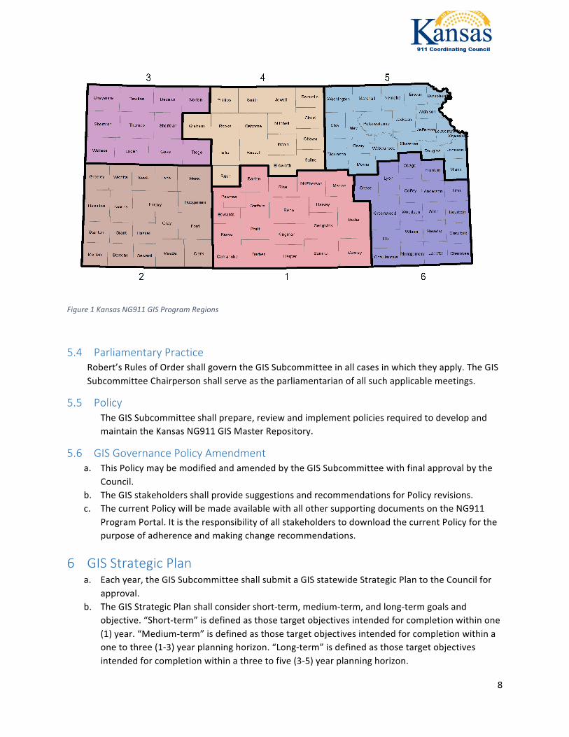
5.3 GISRegionsWithintheGISProgram,thestatehasbeendividedintosixregions,asshowninthemapbelow.Anyactivityinthispolicydescribedasregionaloroccurringinaspecificregionshallusethisdivision.
8
Figure1KansasNG911GISProgramRegions
5.4 ParliamentaryPracticeRobert’sRulesofOrdershallgoverntheGISSubcommitteeinallcasesinwhichtheyapply.TheGISSubcommitteeChairpersonshallserveastheparliamentarianofallsuchapplicablemeetings.
5.5 PolicyTheGISSubcommitteeshallprepare,reviewandimplementpoliciesrequiredtodevelopandmaintaintheKansasNG911GISMasterRepository.
5.6 GISGovernancePolicyAmendmenta. ThisPolicymaybemodifiedandamendedbytheGISSubcommitteewithfinalapprovalbythe
Council.b. TheGISstakeholdersshallprovidesuggestionsandrecommendationsforPolicyrevisions.c. ThecurrentPolicywillbemadeavailablewithallothersupportingdocumentsontheNG911
ProgramPortal.ItistheresponsibilityofallstakeholderstodownloadthecurrentPolicyforthepurposeofadherenceandmakingchangerecommendations.
6 GISStrategicPlana. Eachyear,theGISSubcommitteeshallsubmitaGISstatewideStrategicPlantotheCouncilfor
approval.b. TheGISStrategicPlanshallconsidershort-term,medium-term,andlong-termgoalsand
objective.“Short-term”isdefinedasthosetargetobjectivesintendedforcompletionwithinone(1)year.“Medium-term”isdefinedasthosetargetobjectivesintendedforcompletionwithinaonetothree(1-3)yearplanninghorizon.“Long-term”isdefinedasthosetargetobjectivesintendedforcompletionwithinathreetofive(3-5)yearplanninghorizon.
9
c. TheGISStrategicPlanshallbedevelopedthroughacombinationofstrategicplanningworkshops,reviewofexistingregionalstrategicplansandGISsubcommitteemeetings.
d. TheGISStrategicPlanshallbeconsistentwithapplicableprovisionsofNG911guidelinesoftheFCC,NENAandotherGIS-relateddecisionmakingbodies.
7 GISOperationsWorkPlana. Eachyear,theGISSubcommitteeshallsubmitaGISstatewideOperationsWorkPlantothe
Councilforapproval.b. TheGISOperationsWorkPlanshallincludethedefinedobjectivesstatedinorimpliedbytheGIS
StrategicPlan.c. TheGISOperationsWorkPlanshallbedevelopedthroughGISsubcommitteemeetings.d. TheGISOperationsWorkPlanshallprovidefortheon-goingmaintenanceoftheKansasNG911
GISMasterRepository.
8 GISDataStandardsandRemediationGuidelinesa. GISSubcommitteeshallmaintaintheKansasNG911GISDataModel.Thisdocumentestablishes
GISdatastandardsforNG911requireddatalayers(roadcenterlines,addresspoints,authoritativeboundaries,emergencyserviceboundaries,emergencyservicezones,androadaliastable),andrecommendeddatalayers(states,counties,cellsector,municipalboundaries,amongothers).
b. InputfromGISSubjectMatterExperts(SME)fromStateandlocalgovernment,aswellastheprivatesectorwillbeconsideredonupdatestotheKansasNG911GISDataModel.
c. Totheextentpractical,theKansasNG911GISDataModelwillalignwiththemostrecentversionoftheNENAStandardforNG911GISDataModel.
9 CommunicationPlana. TheGISSubcommitteeshallcommunicatewithNG911stakeholdersshowninTable2.b. TheGISSubcommitteeshallpreparetheGISrelatedportionoftheNG911CommunicationPlan
andsubmitittotheOperationsCommitteenolaterthanMarch1.c. ElementsoftheGISCommunicationPlaninclude,butarenotlimitedto:
i. Projectstatusii. Projectdirectivesandannouncementsiii. Applicabledocumentchangesiv. ChangeOrderRequestapprovalsandrejectionsv. Testimonybeforelegislativecommitteesvi. Informationforlegislativeresearchorpostaudit,asrequired
d. Communicationtoolswillinclude,butarenotlimitedto,meetings,websites,theProgramPortal,directe-mail,andsocialmedia.
10 TrainingPlana. TheGISSubcommitteeshalldevelopanddeliveratrainingandcertificationprogramthat
addressesGISasitrelatestoNG911.

10
b. TheobjectiveofthetrainingprogramistoensurethatallstakeholdersunderstandtheimportanceofGIStoNG911andtheirresponsibilitieswithintheGISprogram.
c. TheGISSubcommitteeshallpreparetheGISrelatedportionoftheNG911TrainingPlanandsubmitittotheOperationsCommitteenolaterthanMarch1.
d. TheGISTrainingPlanshallinclude,butnotbelimitedto:I. GISandNG911Orientation;II. GISdatamaintenanceanddatasubmission;III. ResponsibilitiesofLocalDataStewards.
e. TheGISSubcommitteeChairpersonshallmaintaincertificationrecordsontheNG911ProgramPortal.
f. Trainingwillfocusontwo(2)majorelements.TechnicaltrainingwillfocusonGISdatamaintenanceanddatasubmissionasperthestandardpresentedintheKansasNG911GISDataModel.PolicytrainingwillfocusontheGISProgramasawholeandtheresponsibilitiesofLocalDataStewards.
g. Trainingwillbeamixtureofliveclassesandwebinars.SomesessionswillberecordedandmadeavailableforviewingontheKansasNG911website.
11 PublicRelationsPlana. TheGISSubcommitteeshallpreparetheGISPublicRelations(PR)Planandsubmitittothe
AdministrationCommitteenolaterthanMarch1.b. TheGISPublicRelationsPlanwillincludematerialsandpresentationsdirectedtowardincreased
understandingoftheproject.c. TheGISSubcommitteewillutilizeprofessionalconferencesattendedbystakeholderstoeducate
communitiesregardingtheNG911system.d. AllGISPRmaterialsintendedforofficialpublicdisseminationshallbepre-approvedbythe
CouncilChairperson.
12 ChangeManagementPlana. TheGISChangeManagementPlan,adedicatedsectionoftheNG911ChangeManagementPlan,
shalladdresschangestotheGISMasterRepositoryandtheKansasNG911GISDataModel.b. AnystakeholdermayrequestchangebycompletingandsubmittingaChangeOrderRequest
(COR).TheCORshalldefinetherequestedchange,describefullytherationaleforthechange,andaddresstheimpact(cost,schedule,performance,training).
c. TheGISChangeControlBoard(CCB)shallbecomposedoftheChairpersonandtwomembersoftheGISSubcommitteeappointedbytheChairperson.
d. TheGISChangeControlBoardshallacceptandreviewCORs,providingrecommendationsontheCORstotheGISSubcommitteeasawhole.TheGISSubcommitteewillthenvotetoapprovethechange,denythechange,orrequestmoreinformationfromtheoriginatoroftheCORoranothersubjectmatterexpert.TheCCBwillcarryouttheactionchoseninthevote.
e. TheGISChangeControlBoard(CCB)shallholdmeetingsasneededtoaddressCORs.
11
13 SecurityPlanAformalsecurityplanwillbedraftedaftertheNG9-1-1InfrastructureRFPhasbeenawardedtoensureproperalignmentwithnetworkprotocolsandprocedures.
14 Reportsa. TheGISSubcommitteeChairpersonshallpreparevariousreportssuchas:
i. GISStatusReportsubmittedtoCouncilquarterlyandasrequiredii. GISProgressReportsubmittedtoCouncilannuallyattheendofeachfiscalyeariii. GISFinancialReportsubmittedtoCouncilannuallyattheendofeachfiscalyear
15 GISBudgeta. Eachyear,startingthefirstweekofOctober,theGISSubcommitteeshallreviewandrefinethe
GISoperationsbudgetforthenewfiscalyear.ThefinalGISBudgetshallbesubmittedtotheCouncilforreviewandapprovalinDecemberofeachyear.TheformatoftheGISBudgetshalldirectlyderivefromandbecompatiblewiththeCouncilAnnualBudgetformat.
b. TheGISbudgetshallconsiderandcaptureanyneworemergingcostelementsresultingfromallGISProgramplans.
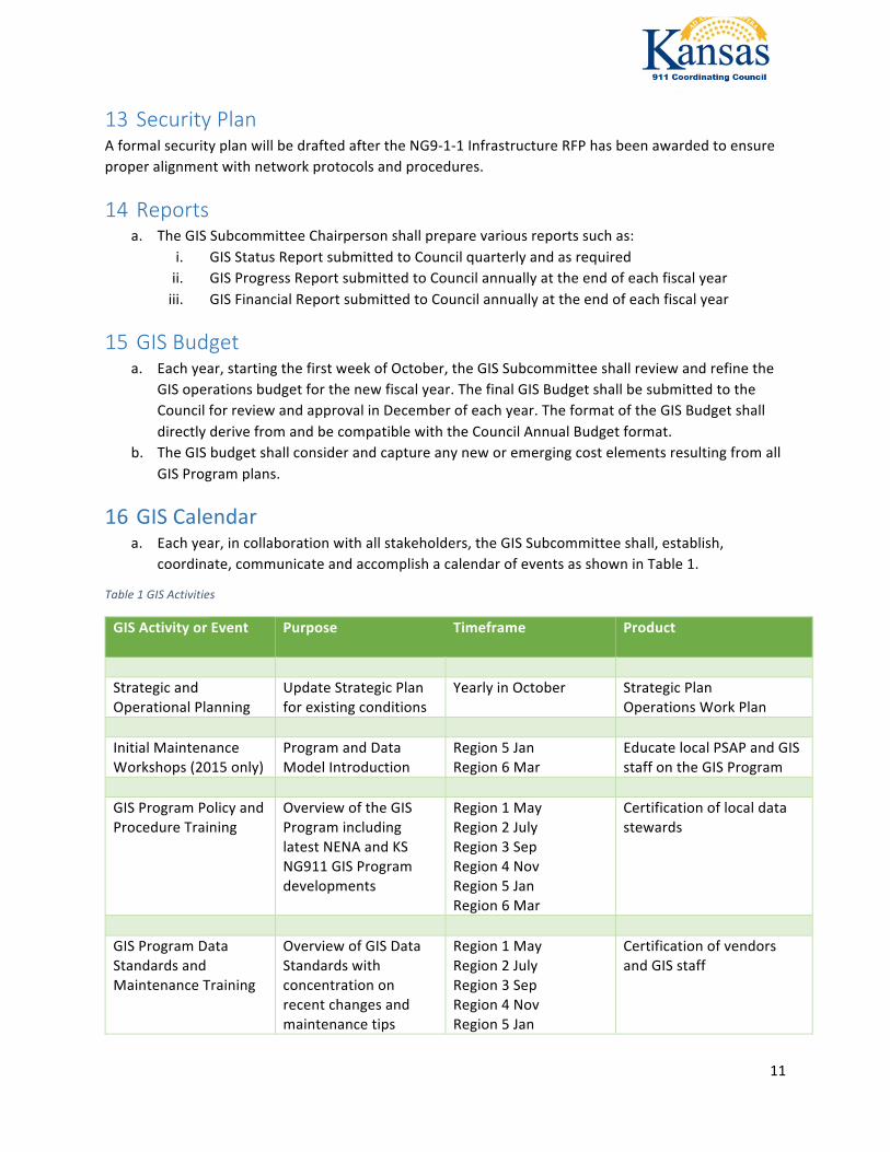
16 GISCalendara. Eachyear,incollaborationwithallstakeholders,theGISSubcommitteeshall,establish,
coordinate,communicateandaccomplishacalendarofeventsasshowninTable1.
Table1GISActivities
GISActivityorEvent
Purpose Timeframe Product
StrategicandOperationalPlanning
UpdateStrategicPlanforexistingconditions
YearlyinOctober StrategicPlanOperationsWorkPlan
InitialMaintenanceWorkshops(2015only)
ProgramandDataModelIntroduction
Region5JanRegion6Mar
EducatelocalPSAPandGISstaffontheGISProgram
GISProgramPolicyandProcedureTraining
OverviewoftheGISProgramincludinglatestNENAandKSNG911GISProgramdevelopments
Region1MayRegion2JulyRegion3SepRegion4NovRegion5JanRegion6Mar
Certificationoflocaldatastewards
GISProgramDataStandardsandMaintenanceTraining
OverviewofGISDataStandardswithconcentrationonrecentchangesandmaintenancetips
Region1MayRegion2JulyRegion3SepRegion4NovRegion5Jan
CertificationofvendorsandGISstaff
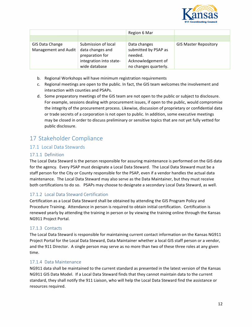
12
Region6Mar GISDataChangeManagementandAudit
Submissionoflocaldatachangesandpreparationforintegrationintostate-widedatabase
DatachangessubmittedbyPSAPasneeded.Acknowledgementofnochangesquarterly.
GISMasterRepository
b. RegionalWorkshopswillhaveminimumregistrationrequirementsc. Regionalmeetingsareopentothepublic.Infact,theGISteamwelcomestheinvolvementand
interactionwithcountiesandPSAPs.d. SomepreparatorymeetingsoftheGISteamarenotopentothepublicorsubjecttodisclosure.
Forexample,sessionsdealingwithprocurementissues,ifopentothepublic,wouldcompromisetheintegrityoftheprocurementprocess.Likewise,discussionofproprietaryorconfidentialdataortradesecretsofacorporationisnotopentopublic.Inaddition,someexecutivemeetingsmaybeclosedinordertodiscusspreliminaryorsensitivetopicsthatarenotyetfullyvettedforpublicdisclosure.
17 StakeholderCompliance17.1 LocalDataStewards17.1.1 DefinitionTheLocalDataStewardisthepersonresponsibleforassuringmaintenanceisperformedontheGISdatafortheagency.EveryPSAPmustdesignateaLocalDataSteward.TheLocalDataStewardmustbeastaffpersonfortheCityorCountyresponsibleforthePSAP,evenifavendorhandlestheactualdatamaintenance.TheLocalDataStewardmayalsoserveastheDataMaintainer,buttheymustreceivebothcertificationstodoso.PSAPsmaychoosetodesignateasecondaryLocalDataSteward,aswell.
17.1.2 LocalDataStewardCertificationCertificationasaLocalDataStewardshallbeobtainedbyattendingtheGISProgramPolicyandProcedureTraining.Attendanceinpersonisrequiredtoobtaininitialcertification.CertificationisrenewedyearlybyattendingthetraininginpersonorbyviewingthetrainingonlinethroughtheKansasNG911ProjectPortal.
17.1.3 ContactsTheLocalDataStewardisresponsibleformaintainingcurrentcontactinformationontheKansasNG911ProjectPortalfortheLocalDataSteward,DataMaintainerwhetheralocalGISstaffpersonoravendor,andthe911Director.Asinglepersonmayserveasnomorethantwoofthesethreerolesatanygiventime.
17.1.4 DataMaintenanceNG911datashallbemaintainedtothecurrentstandardaspresentedinthelatestversionoftheKansasNG911GISDataModel.IfaLocalDataStewardfindsthattheycannotmaintaindatatothecurrentstandard,theyshallnotifythe911Liaison,whowillhelptheLocalDataStewardfindtheassistanceorresourcesrequired.
13
17.1.5 SubmissiontoGISMasterRepositorya. LocalDataStewardsareresponsibletosubmitdataupdatestotheGISMasterRepository.b. DataupdatesshallbesubmittedintheKansasNG911TemplateGeodatabaseformat.c. IfactualmaintenanceoftheGISdataisperformedbyavendor,theLocalDataStewardmay
authorizethevendortosubmitdatachangesontheirbehalf.However,theLocalDataStewardisstillresponsibleforthesubmission.
d. Thefrequencyofdataupdatesisalocaldecisiontobedeterminedbylocalneedsandtheamountandfrequencyofchanges.Ifnodatachangesareneeded,LocalDataStewardsshallsubmita“NoChanges”statementviaKansasNG911ProjectPortalatleastquarterly.
17.2 DataMaintainers17.2.1 DefinitionTheDataMaintaineristheprimarypersonwhowillbeperformingtheactualmaintenanceoftheGISdatafortheagency.TheDataMaintainermustacquireandmaintaincertificationfortherole.
17.2.2 LocalGISDataMaintenanceStaffCertificationforLocalGISDataMaintenanceshallbeobtainedbyattendingtheGISProgramDataStandardsandMaintenanceTraining.Attendanceinpersonisrequiredtoobtaininitialcertification.CertificationisrenewedyearlybyattendingthetraininginpersonorbyviewingthetrainingonlinethroughtheKansasNG911ProjectPortal.
17.2.3 GISVendorscontractedforlocaldatamaintenancea. CertificationforLocalGISDataMaintenanceshallbeobtainedbyattendingtheGISProgram
DataStandardsandMaintenanceTraining.Attendanceinpersonisrequiredtoobtaininitialcertification.CertificationisrenewedyearlybyattendingthetraininginpersonorbyviewingthetrainingonlinethroughtheKansasNG911ProjectPortal.
b. VendorsmusthavecurrentLocalGISDataMaintenancecertificationbefore911fundscanbeusedtopaytheircontractedfees.
17.3 DataConsumers17.3.1 DefinitionDataConsumersareindividualsorgroupsthatmayhaveneedforthedataintheGISMasterRepositoryoutsideofitsprimarypurposeinNG911.
17.3.2 ApprovedUseTheMemorandumofUnderstanding(MOU)signedbytheChairmanofthe911CoordinatingCouncilandbyarepresentativeofeachPSAPallowsthattheGISdatacollectedintheGISMasterRepositorymaybeusedbyPSAPs,localgovernmentsandstategovernmentalagenciesforothergovernmentalbusinesspurposes.TheGISdatamaynotbesold,releasedtoorotherwiseprovidedtobusinessesandothernon-governmentalorganizationswithoutthewrittenauthorizationofthe911CoordinatingCouncil.
17.3.3 DataRequestsIndividualsandagencieswishingtorequestaccesstothedataintheGISMasterRepositoryshallsubmittheirrequestthroughtheKansasNG911ProgramPortal.
14
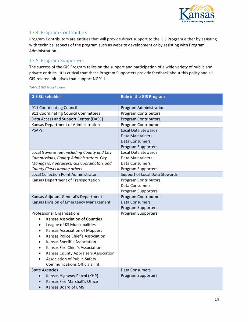
17.4 ProgramContributorsProgramContributorsareentitiesthatwillprovidedirectsupporttotheGISProgrameitherbyassistingwithtechnicalaspectsoftheprogramsuchaswebsitedevelopmentorbyassistingwithProgramAdministration.
17.5 ProgramSupportersThesuccessoftheGISProgramreliesonthesupportandparticipationofawidevarietyofpublicandprivateentities.ItiscriticalthattheseProgramSupportersprovidefeedbackaboutthispolicyandallGIS-relatedinitiativesthatsupportNG911.
Table2GISStakeholders
GISStakeholder
RoleintheGISProgram
911CoordinatingCouncil ProgramAdministration911CoordinatingCouncilCommittees ProgramContributorsDataAccessandSupportCenter(DASC) ProgramContributorsKansasDepartmentofAdministration ProgramContributorsPSAPs LocalDataStewards
DataMaintainersDataConsumersProgramSupporters
LocalGovernmentincludingCountyandCityCommissions,CountyAdministrators,CityManagers,Appraisers,GISCoordinatorsandCountyClerksamongothers
LocalDataStewardsDataMaintainersDataConsumersProgramSupporters
LocalCollectionPointAdministrator SupportofLocalDataStewardsKansasDepartmentofTransportation ProgramContributors
DataConsumersProgramSupporters
KansasAdjutantGeneral’sDepartment–KansasDivisionofEmergencyManagement
ProgramContributorsDataConsumersProgramSupporters
ProfessionalOrganizations• KansasAssociationofCounties• LeagueofKSMunicipalities• KansasAssociationofMappers• KansasPoliceChief’sAssociation• KansasSheriff’sAssociation• KansasFireChief’sAssociation• KansasCountyAppraisersAssociation• AssociationofPublic-Safety
CommunicationsOfficials,Int.
ProgramSupporters
StateAgencies• KansasHighwayPatrol(KHP)• KansasFireMarshall’sOffice• KansasBoardofEMS
DataConsumersProgramSupporters
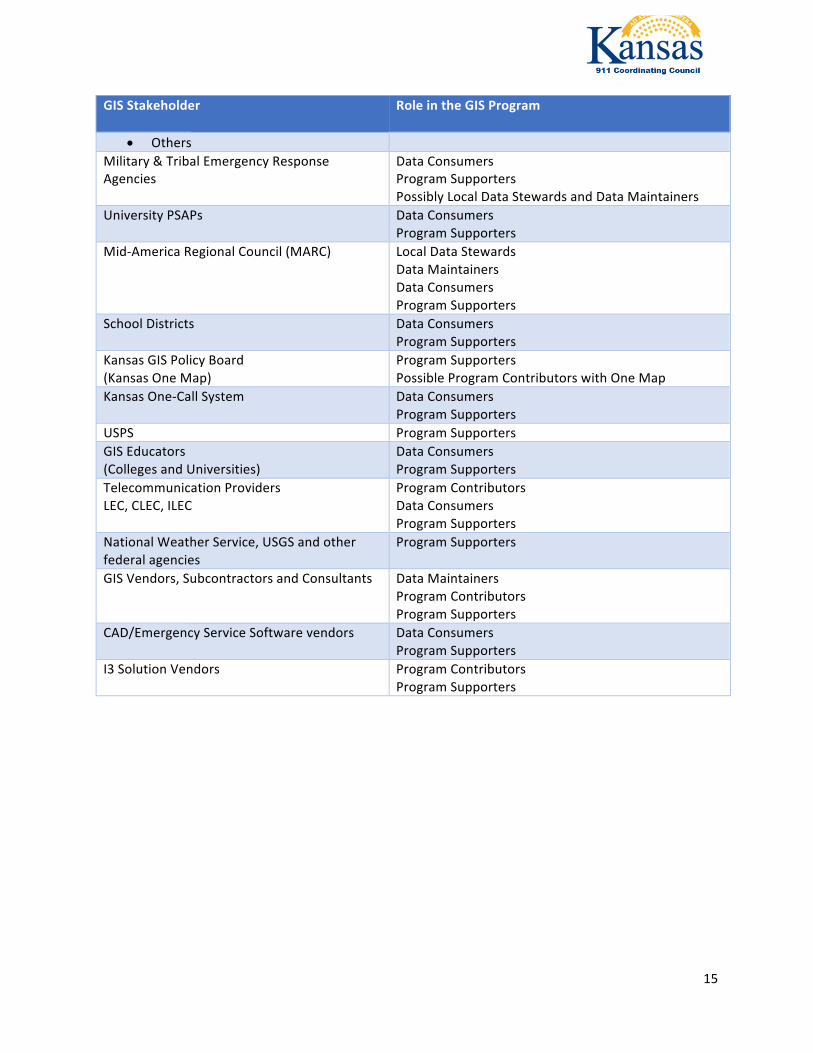
15
GISStakeholder
RoleintheGISProgram
• OthersMilitary&TribalEmergencyResponseAgencies
DataConsumersProgramSupportersPossiblyLocalDataStewardsandDataMaintainers
UniversityPSAPs DataConsumersProgramSupporters
Mid-AmericaRegionalCouncil(MARC) LocalDataStewardsDataMaintainersDataConsumersProgramSupporters
SchoolDistricts DataConsumersProgramSupporters
KansasGISPolicyBoard(KansasOneMap)
ProgramSupportersPossibleProgramContributorswithOneMap
KansasOne-CallSystem
DataConsumersProgramSupporters
USPS ProgramSupportersGISEducators(CollegesandUniversities)
DataConsumersProgramSupporters
TelecommunicationProvidersLEC,CLEC,ILEC
ProgramContributorsDataConsumersProgramSupporters
NationalWeatherService,USGSandotherfederalagencies
ProgramSupporters
GISVendors,SubcontractorsandConsultants
DataMaintainersProgramContributorsProgramSupporters
CAD/EmergencyServiceSoftwarevendors DataConsumersProgramSupporters
I3SolutionVendors ProgramContributorsProgramSupporters