Embed Size (px)
Citation preview
EMDS 3.0: A modeling framework for coping with complexity in environmental assessment and planning Keith M. Reynolds
U.S. Dept. Agriculture, Forest Service, Pacific Northwest Research Sation, 3200 SW Jefferson Way, C0r- vallis, OR 97331, USA &mail: kmp0MSOts.fed.o~) Receiived October 10,2005; amepted Apd 12,2006
Abstract The Ecosystem Management Decision Support (EMDS) system is an appli- cation framework for knowledge-based decision support of ecological assessments at any geographic scale. The system integrates state-of-the-art geographic infomation system @IS) as well as knowledge-based reasoning and decision modeling technologies to pro- vide decision support for a substantial porfron of the adaptive management process of ecosystem management. EMDS 3.0 is implemented as an ~ r c ~ a p @ extension and inte- grates the logic engine of ~ e t ~ e a v e ? tdperform landscape evaluations, and the decision modeling engine of Criteriurn ~ e c i s i o n ~ l u s ~ for evaluating management priorities. Key features of the system's evaluation component include abilities to {If reason about large, abstract, multi-faceted ecosystem management problems, (2) perform useful evaluations with incomplete information, (3) evaluate the influence of missing information, and (4) determine priorities for missing information. A key feature of the planning component is the ability to determine priorities for management activities, taking into account not only ecosystem condition, but also criteria that account for the feasibiiity and efficacy of goten- tial management actions, Both components include powerful and intuitive diagnostic features that facilitate communicating the explanation of modeling results to a bruad au- dience.
Weywurdsr rriltural m u m s , mo&h& asmsmmt. analysis, @sning, &wane, emsystem managmmt.
The Ecosystem Management Decision Support, lEMDS) system is an application framework for knowledge-based decision suppsrt sf ecological assessments at any geo- graphic scale. The system ink,@tes state-of-the-art geographic informatinn system (GIs) as well as knowledge-based reasoning and decision modeling tecbnologjes in the Micro- s& W'indowp (bereafter, windows) environment tn provide decision support for a sub- stantial portion of the adaptive management process of ecosystem management.
EMDS version 3.0 was developed for the iISDA Forest Service under contracr with
63 Scie~lcc in Chipla: Series E Techtrologi~;itl Srierica
the Environmental Systems Research Institute (ESRI, Redlands. CA) to provide decision support fur landscape analysis and planning. The initial release of version 1.0 in February 1997 integrated logic processing of landscape information, based on the ~ e t ~ e a v e r ' fuzzy logic engine (Rules of Thumb, Inc. J, into the ArcView GIs environment"'. EMDS .
version 3.0 i s a major re-engineering of the system for AEGIS 8.1 (or later) COM-based technology and Windows XP or 2000121. Version 3.0 extends the originat scope of the EMDS application to include integrated planning functions provided by the Weighted Decision Object, an engine by 1nfoHarvest (Seattle. WA) that implements the analytic hierarchy process (AHP) for setting priorities, selecting alternatives, and allo- cation of organization, dl 1 ~soufces.
The assessment and planning features of EMDS version 3.0 are illusmated with an integrated. multi-wale example designed to (1) evaluate salmon habitat potential in stream reaches and subwatersheds. and (2) establish priorities for protection and restora- tion nf stream reaches and watersheds. based on result5 of landscapc assessments and additional considerations of r@rstrmxion efficacy and feasibility.
I Background
Beyond GIs. the core technologies underlying EMDS are likely to be unfamiliar tto
many, if not most readers, so this section provides a general overview of concepts related to logic and decision modeling.
Basic co~lcepts of approximate reasoning with fuzzy logic were first presented by ~adeh[~*'. S~ibsequent concept eetaborated on the syntax and semantics of lin- guistic variables. laying the foundation for what has become a significant branch of ap- plied mathematics. Fuzzy logic is concerned with quantification of set membership and associated set uprations. ~orrnall~~'''. let E be a set, denumerable or not. and let x be an element of E. Then a fuzzy subset A of E is a set of ordered pairs {x, A@)). in which A(.r) is a membership function that takes its values from the set M = fO. I], and specifies the degree of membership of x in A. Because fuzzy set theory is a generalization of Boolean set theory, most Boolean set oprations have equivalent operations in fuzzy subsets""'.
Application of fuzzy logic to natural resource management is still relatively novel. General areas of application include classification in remote sensingt'", environmental
113.141 risk assess~nent~'~~. phytosaeiology , ee~Fdphyllsl. ecosystem research[16', and envi- ronmental asscssrnentll'. 18'. More specific applications inclrtde catchment modeling"Y1.
p' '31 cloud classification'"'. evaluation of plant nutrient supply'?". soil interpretahon ---. . land suitability fbr crop production'24!, ecological site c~assification'~'~, watershed as- sessment for total maximum daily load of non-point source po~utants'~". md bidvcr- sity system desigd2".
A logic model represents krrowlcdge nbisut hour ro sohe a problem in some domain of inrerest. Several different approaches to knowledge-based represenh6on have been de- veloped over the last 30 EEILlDS lncoprates the NetWeitver logic e~gine for

knowledge-based msoningrB301. This system implements a logic model as hierarchies of dependency networks. The logic model that an assessment team constructs with Net- Weaver is best thought of as a meta database that interprets data processed by an infer- ence engine,
An aswt of logic-based modeling that makes it quite useful in ecological assessment is that svch systems can reason with incomplete information. B r example, the Net- Weaver engine provides paaial evaluations of ecosystem states and processes, based on available infomation; it also provides useful infomation about the influence of missing data which can be used to improve completeness of an assessmeat. In the future, assess- ment teams may be able to assemble a list of all topics they want ro include in an assess- ment, assemble a list of data requirements needed to address those topics, and find they have all the required data. For the foreseeable future, however, assessments miineiy need to deal with incomplete d;tta. There may be some missing observations for several to many data types. There may be no data at dl for possibly many others. The Netweaver engine incorporated into EMDS uses a simple algorjb to compute the influence of missing data based on the logical structure of the model, how many states and processes use rhe information. and at what level the infonnation enters the model structure. The Data Acquisition Manager (DAM) in EMDS uses infonnation about data iduence to assist users with prioritizing new data acquisition needs.
1.2 Decision modelitig
A multi-criteria decision problem generally involves choosing one of a number of ai- ternatjves based on how well those alternatives rate against a chosen set of shuctured and weighted criteria (the decision model). Tbe criteria themselves are weighted in terms of importance to the decision maker, and the overall score of an alternative is he weighted sum of its rating against each criteria. The ordering of the .alternatives by their decision WOKS is a prioritized ranking ctf those alternatives by preference. Decision analysis pro- vides a number of analytic tools, such as sensitivity analysis and tradeoff analysi that validate the reasonableness and robustness of a given decision m&J. Two primary deci- sion-making methodologies in wide use are the Analytical Hierarchy Process (Al-lR 3) and Multi-attribute Urility Theory implemented in the Simple Multiataihte Rating ~echni~ue'~'"" (SMART).
2 EMDS system components
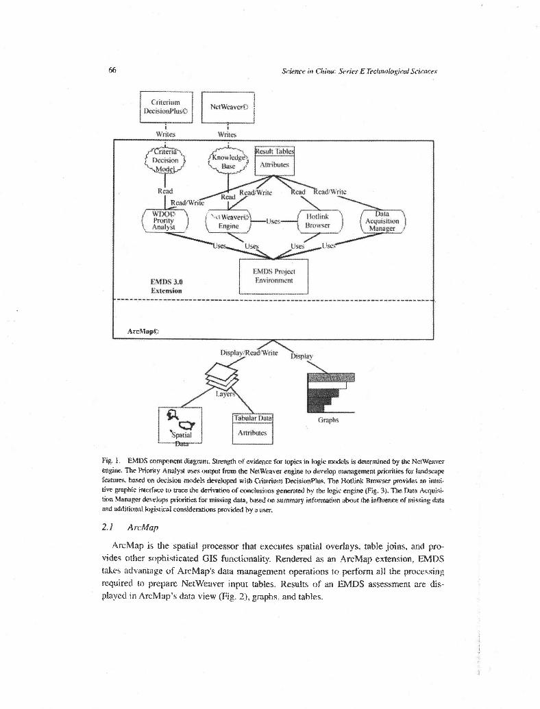
The EMDS component diagram illustrates the basic architecture of EMDS 3.0 and the flow of infonnation mong system companents (Fig. 1 ). Note that Netweaver Developer and CritMiurn ~erision~lus@ are external development tools needed to create logic and decision models. respectively. Major components of EMDS are described in the follow- ing subsections.
kicttcr i r z China: Series E Technological Scimces
1vites writes
esult I'ablr Know ledge
Afmhlles
Engine
EMnS Ibject
ems 3.a Envimnmm Extrmiun
---------------------------------------------------*-----------------*-----
g 1. EMDS turnpanent diagram. k g t h nf evidence for topics in Itigk mndels i. dewmined by Ihe NdWmver engine. The Priority Analyst uses oupt fmm the ?%Waver engine to deveIop m a g e m priijrities for hnddsapt featurn. b a d on d~&sion mndels developed with Criteriwn DecisionPlus. The Hotlink Bmwser provides an intui- tive graphic interface io mce the derivatim of conclusions generated by the logic en& (Fig. 3). The Data Acquisi- tion Managw develop priorities for misiog data, based an summary informdon abvur Ibe influence of missing data aod additional hisical clmsidentioas provided by a U.W.
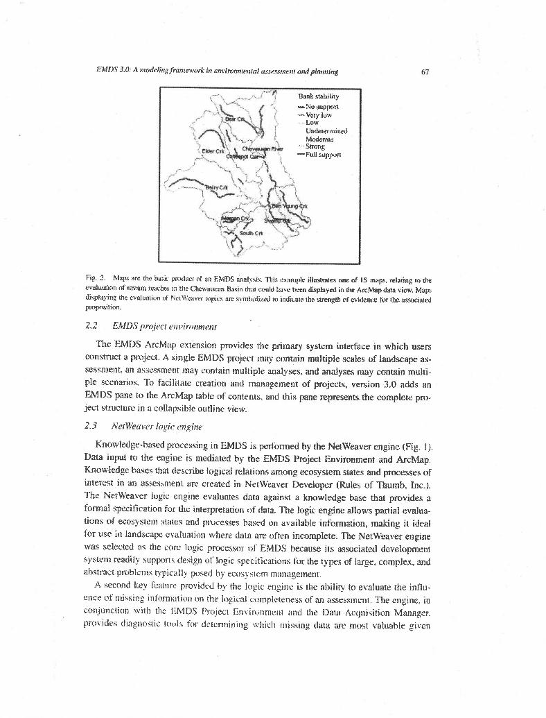
Archlap is the spatial processor that executes spatial overlays. table joins. and pro- vides other sophisticated GIs functionality. Rendered as an ArcMap extension. EMDS takes adv;mrage of ArcMap's data management operations to perform all the processing required to prepam Netweaver input tables. Results of an EMDS assessment are dis- played in ArcMspis data view (Fig. 2). p p h s . and tables.
EMDS 3.0: A modeiingfmrrimwrk in enr*imnn~rntnl assessnlftrr cMd planning
Fig. 2 . Maps are the basic pndaut oi aa EMDS ansll!sis. Tlsis example i l l u m e s one of IS amps, dating 14 h evttluaiun of \nram reaches in the Chewilucan Basin &it could hbe k e n dkpkayed in the ArcMap data view. Map displaying the evaiuatlrm ot Nrl\Vai\.a topics rn symbc>ti~d lo indicate the m s t t , of evidence fur the associated pmpnsidon.
The W D S ArcMap extension provides the primary system interface in which users Consuxct it project. A single EMDS project may contain multiple scales of landscape as- sessment. an assessment may contain multiple analyses, and analyses m y contain multi- ple scenarios. To facilitate creation and management of projects, version 3.0 adds an EMDS pane b the Al-cMap table of contents. and this pane represents.the conlplete pro- ject structure in a collapsible outline view.
Knowledge-based processing in EMDS is performed by the Netweaver engine (Fig. J), Data input to the engine is mediated by the EMDS Pfojtxt Envimnment and Archlap. Knowledge bases that describe logicai relations among ecosystem states and processes of interest in an assessmen1 are created in NetWeaver heloper (Rules of Thumb, Inc.). The Netweaver logic engine evaluates data against n knowledge base that provides n formal specification for the interpretation of data. The logic engine allows pamal evalua- tions of ecosystem slates and processes based on available information, making it ideal for USE in landscape ccaluation where data are often incomplete. The NetWeaver ensine was selected as the core logic processor of EMDS because it5 associated development system readily stippom design of logic specifications for the types of large, complex, and abstract problems typically posed by ecosystem management.
A second key feature provided by the logic engine is the ability to evaiuate the influ- ence of missing information on tlir logical carnpleteness sf an asessrncnt. The engine. in ronjuncrion w ~ t h die EMDS Prijjcct Environment and the Acijuisirion Manager. prmidec; diagnostic tools firr detetmirlir~g which rnl.;siiig data arc most valuable gibcn

68 Science in China: Series E Techmlogic~ Sciences
currently available data and for determining how much priority to give to Illissing data given other logistical information.
2.4 Hotlink Bmwser
After map output for an analysis has been displayed in ArcMap, the Hotlink Browser can be used to view the evaluated state of Netweaver logic models for selected map fea- tures. The graphic display of the evaluated state of a knowledge base is relatively intui- tive. and provides a detailed explanation of the derivation of evaluations that is extremely valuable to EMDS developers, users, and tbe general public (Fig. 3).
Fig. 3. Logic diagram for rhc evaluated state of the rea'ch-condifh topie in !he asses- of stream -. Thc diagram displays the stale of mash condition for n specific map fewurc that bad been SeIecfed witB the Hotlink Browser {Fig. 1 ).
Sophisticated geographic analyses often produce impressive looking mps. However, if the analytical system that produces a map cannot also explain the derivation of analysis results being portrayed in a relatively simple and straightfowatd way, then the system appears to observers as a black box. U'ith the high level of public interest in natural re- source mnage~nent in these times, black box solutions are a political liability. Using the Hotlink Browser, users can navigate the networks of analysis topics to trace the logic of evaluations in an intuitive interface (Fig. 3) . More importantly, the presentation of results in this graphic formar is sufficientt): intuitive that users of the system can use the Hotlink Browser as an effective co~nmunication tmi that effectively explains tfie basis of evalua- tion results to bmad audiences.
Data gaps aw conunon, particularly in the early stages of landscape evaluation. It turns out that, trom a logic perspective. the influence of missing information is very dynamic. The Data Acquisition Manager (DAM), in coniunction with the Netweaver logic engine and the EhilDS Pmject Enkimnment. summarires tt~e influence nf that missing informa-
EIWDS 10: A rnudelingfmmcwork in envil~nmental assessment and plarrrtittg 69
tion, given the information that is currentfy available, and assists the user with establish- ing priorities for obtaining the missing data to improve the logical completeness of an assessment in the most eficient way. A variety of maps. tables, and graphs provide useful information about what data are missing, the influence of missing data on completeness of the assessment, and how it is distributed in the landscape.
2.6 Priority Analyst (PA)
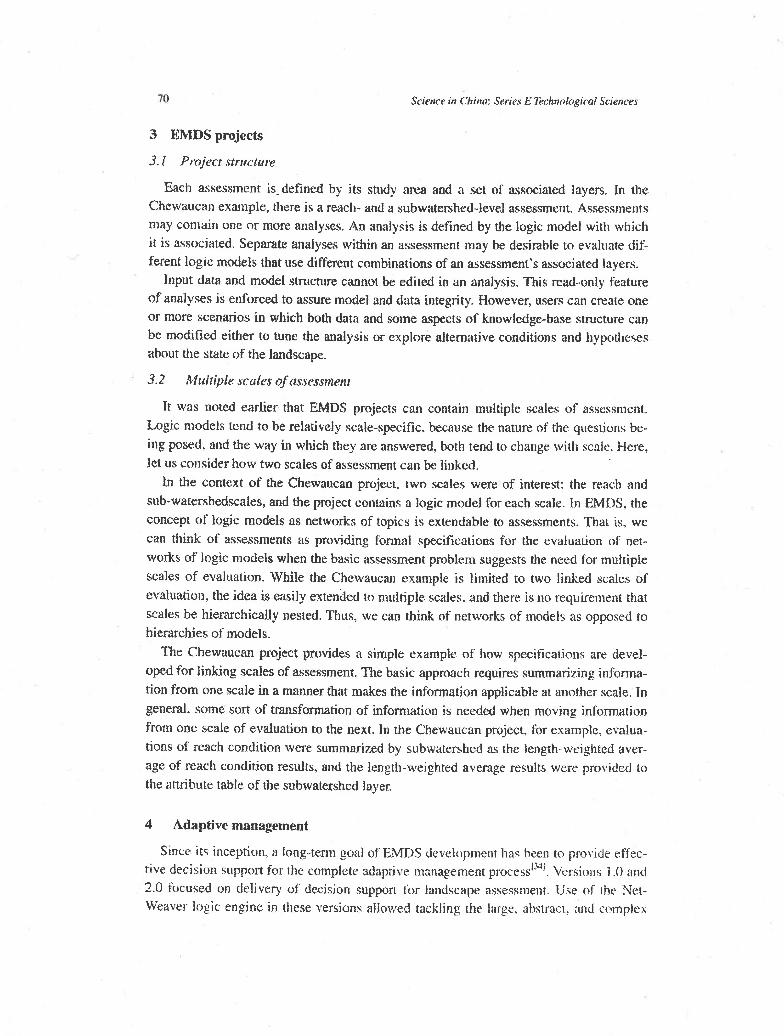
The PA is a dynamic decision tool that extends the functionality of EMDS to include integrated planning, based on decision models designed with Crikrium DecisionPlus (Fig. 4, InfoHarvest). The PA is used for priority setting, resource allocation, and trade-off analysis once a landscape analysis has ken completed. Just as the Hotlink Browser provides usefiil explanation faciiities for understanding evaluation results, PA includes a variety of diagnostic tools that help developers, users, and tale genera! public ~lnderstand the basis for resultant planning priorities.
fig. 4. A decision m&. designed with Crirerim Decis idus . far esrablishg priorities for watershed pmarction and ra~~mtion. Thc o d e 1 is pmcmsed by thc Prioriry Analyst mmpometlt (F& I).
Whereas the logic engine addresses questions about the current state of the asswsment area. PA addresses questions about where to direct management far best effect. For most applications af evaluation and planning, mai~ttajning this distinction is important because the landscape elements in the p r e s t condition are not necessarily also the best cmdi- dares for management activities- such as restoration for example.
PA is a Multi-Criteria Decision Analysis (MCDA) component that assists resource managers in rankiag landscape elements based on how well each rates azainst a s t r of decision criteria. Using output from a landscape evaluation and a decision model de- signed in Criterium DecisionPlus. PA rates the landscape elements not only with respect to their condition, but also with respect to Pacton related to the feasibility and efficacy af management. PA implements twn decision mudel_s; AHP'~, " and SMART"^'.
Science in Cltii~a: Series E Technoiogical Sciences
3.1 Project strllcttrre
Each assessment is. defined by its study area and a set of associated layers. In the Chewaucan example, there is a reach- and a subwatershed-level assessment. Assessments may contain one or more analyses. An analysis is defined by the logic nod el with which it is associated. Separate analyses within an assessment may be desirabie to evaluate dif- ferent logic modds that use different combinations of an assessment's associated layers.
Input data and modeI structure cannot be edited in an analysis. This read-only feature of analyses is enforced to assure mode1 and data integrity. However, users can create one or more scenarios in which both data and some aspecrs of knowledge-base structure can be modified either to tune the analysis or explore alternative conditions and hypotheses about the state of the landscape.
3.2 Multipb scales of assessmenl
It was aoted earlier that EMDS projects can contain multiple scales of assessment. Logic models tend to be relatively scaie-specific. because the nature of the questions be- ing posed. and the way in which they are answered, both tend to change with scale. Here. let us consider how two scales of assessment can be linked.
Zn the context of the Chewaucan project, two scales were of interest: the reach and sub-watershedscales, and the project contains a logic model for each scale. In EMDS. the concept of logic models as networks of topics is extendable to assessments. That is, we
can think of assessments as providing formal specifications for the evaluation of ner- works of logic models when the basic assessment problem suggests the need for multiple scales of evaluation. While the Chewaucan example is limited to two linked scales of evaluation. the idea is easily extended to multiple scales, and there is no requirement that scales be hierarchically nested. Thus, we can think of networks of models as opposed to hierarchies of models.
The Chewaucan project provides a simple example of how specifications are devel- oped for linking scales of assessment. The basic approach requires summatizing infonna- tion from one scale in a manner that makes the information applicable at another scale. In general, some sort of msformation of information is needed when moving infcmation from one scale of evaluation to the next. In the Chewaucan project, for example, evalua- tions of reach condition were summarized by subwatershed as the length-weighted aver- age of reach condition results. and the length-weighted average results were provided to the attribute taMe of the subwatershed layer.
4 Adaptive management
Since its inception, a long-term goal of EMDS dzvetapment has been to provide effec- ti,, decision support for the cotnplete adaptive management process"4'. Versions 1.0 and 2.0 focused on delivery of decision support for landscape aswssment. Use of Lhe Net-
Weaver logic engine in these versions allowed tackling the large. abstract. and co~nplcx

EMnS 30: A nvodelingjrmework in c~zvimnm~ntnl assessment and planning 7 1
questions that are now typically posed in the context of ecosystem management. Feed- back from the EMDS user community has consistently vaCdated the original develop- ment team's belief that a logic-based aggrnach, that could evaluate incomplete informa- tion and the influence of information, would be extremely useful for landscape assess- ment. The logic specifications developed for assessment also. in a sense, provide a back- door into the monitoring phase of the adaptive management process. In version 3.0, the complete re-engineering of LIDS into a COM-based application also afforded tfie op- portunity to significantly extend the system's support of the adaptive management proc- ess through integration of the new Priority Analyst component hat supports the planning phase of the process.
5 Adaptive stralegic planning
The application of logic n~odels to assessment in the context of adaptive management is eady extended to strategic planning. In fact, h e traditional approach to strategic plan- ning begins with a r ~ identification of driving issues and an assessment of current condi- tions with .respect to the i~sues''~'. Historically, strategic planning cycles have been im- plemented on a regular temporal cycle (e.g., the planning process of the U.S. Depament d Agriculture, Forest Service). This need not be the case. however. The structure of a logic model can, in principle, encapsulate the cenml issues that drive a strategic planing process in precisely the same way as we have described for ecosystem assessment in the adaptive m&nagement process. If the issues identified in the current plan remain valid, and no new ones have emerged since the start of the current planning cycle, then &is would suggest that there is no need for a major overhaul of the existing plan, but perhaps cmly millor inmemental. evolutionary changes, similar to the adaptive management pro- cess.
NOW, however. let us consider the sirnation in which a strategic forest plan does re- quire revision, and a new assessment of current conditions has been produced. The tradi- tional approach to strategic planning cdb for h e identification of a few, to several, stir-
tcgic alternatives that effectively bound the decision Ideally, the design of each alternative is responsive to the same issues originally driving the planning process, so it seeins only reasonable that the alternatives are assessed in a manner consistent with that used to assess the current condition. The application of a formal logic in assessment of both cunent conditions and projections based on strategic alternatives can provide an effective measure of quality assurance with respect to consistent interpretation of com- plex infomation that i q otherwise rather difficult to demonstrate.
Up to this p i n t , we have considered the stpplication of logic models to assessment of current condition and strategic alternatives. However. they also are equally applicable to evaluating the progress of plan implementation. In other wards, having chosen a strategic alternative. some 5 or 10 years later. we would like to evaluate whether the plan is per- timning adequafdy. Again. it seems only reasonabIe to apply the same logic model to this phase of the plan.
72 Scirnce in Chi~zn: Series E Et-hnologircti Sciences
6 Discussion and conclusioas
Since the initial release of EMDS in 1997, i t has proven to be reasonably succesdul as an approach to providing decision support for environmental assessment. A number of published accounts of application development with EMDS can be found both within the
scientific literature (for example, refs. [25-271, but also several others) and on the inter- net. Tts logic-based approach to accommodating the types of large, abstract problems typical of modem ecosystem management is certainly one important reason for success. Another important reason, closely related to the first, was the development team's decision to implement a very generic framework, suitable for diverse problems and scales of analysis.
While version 3.0, described here, represents a significant step in the evolution of the EMDS design since the initial release, there is still considerable room for continued de- ~elopment. For example, if the system is to pmvide comprehensive support for the adap- tive management process, it will need to explicidy support the implanentation phase of the process. However, provision for a new component to support testing hypotheses about results obtained from consecutive assessments would be much more significant. It is difficult to overstate the practical consequences of such a development: perhaps one of h e greatest difficulties that scientists and managers have encountered in trying to effec- lively demonstrate adaptive management revolves around precisely this issue when tht: objects of management concern relatively abstract things.
The development systems for logic and decision modeling that are used with EMDS often are unfamiliar to forest managers and natural resource scientists, so readers poten- tially interested in using the system may have concerns about ease of learning. Similarly, there also may be concern because EMDS is implemented as an extension to ArcGIS, which itself is a powerful and complex system for geographic analysis. T have presented a number of W O ~ ~ S ~ O Q S over the past eight years. and found that comprehensive iasmc- tot-led training typically requires about four days. However. EMDS also comes with a comprehensive user guide and in-depth tutorials, and quite a few users have repofled these materials were sufficient to quickly master the skills required to use the system ef- fectively. Furthermore, although EMDS is an ArcGTS extension, users are somewha in- sulated from the ArcGIS environment. and need only a relatively modest understanding of GTS in order to use the system effectively. Finally, when the system is fielded as an application within natural resource organizations, there effectively are three distinct lev- els of user: (1 ) the so-called power user, who understands how to build the models. and assemble them with GIS data into a complete EMDS application: (2) an intermediate user, who does not have the skills to build the models, but who can take existing models, and assemble an application: and (3 ) a basic user, who simply needs to know how to run an ewiqting EMDS application. Whereas, the comprehensive trajning for a power user re- quires about four days. the basic rraining only requires about four hours.
There are at least three imponant and pradicnl implicatiolzs of the framework. First, the logic- and decision-modelirtg components are designed to compiement each other.
E.4fDS 3.0: A m w l e l i r r g f r in ~ ~ V I ~ O ~ I Y N L ~ ~ assessment n d ptunnit~g 73
and break the overalf analytical process into two conceptually simpler steps. Within the logic component, the emphasis is on interpretation and synthesis. Syntheses perfumed in the logic component often allow the desi_m of n smaller and simpler decision model. The emphasis within the decision component is on weighting of decisian criteria and ac- counting for arldjtional logistical considerations that may influence priorities for mm- agement action. Second. the EMDS framework is designed to make the concept of adap tive management practical and operational. Although the curtent implementation does not provide explicit support for hypothesis testing as noted earlier, this i s easily implemented by users with a reasonable understanding of statistical methods. Third, as suggebted un- der Adaptive strategic planning, impfernentadon of an EMDS application in this con- text can acid greater coherence to the uvenil process by effectively infusing institutional memory into the process.
Finally, the full polential offhe current EMDS version has yet to be fully demonstrated. Fm~n the previous section, it is not diff~cuh to describe a methodology for logic applica- tions h e . in principle, unifies the concepts of' strategic planning and adaptive m a n a p ment within a single practical framework.
Endnotes The use of trade or f i m ~ names in this paper is for reader infc)rmation and does not imply endorsement by the U.S. 13epiarnent of Agriculture of m y product or service. The EMDS system can be Jownlorrdcfd from http:Nwww.fsl.orsr.edu/ emds.
Ackmwieclgments Special thanks to: David Hohler (USDA Fatest Service, Natural Resource Enformation System Tmls Group) for funding de~eloprnent of EhmS 3.0. Miehiiel Saunders and Bruce Miller at Rules of Thumb. Inc. ibr providing the Nerbi'e~ver runtime and QCX development for FMDS. Philip Mnrphy and Kelle~ Hcvms at InfoHarvest Inc, for development of the Priority Andyst cornponeat, and providing the Criterium DecisionPlt~s runtin-ie. Dick Lawrence and Sergio Rodriguez at Ef RJ for prcrject mnanagement. Dayid Bork1t.y and Xinnong Zhou at ESRl ih Im- plementation of the EMRS At-cMap extension ,and component inregration.
References
I Reynolds R M. EMDS uses guide (version 2.Q: k~o'alcdge-bami dnhian suppon lor sc~logicai as=ssmenl,
&a. Tech. Rep. PhW-GlX-470. Portland. Oregon: LY.S. Depanrnent of .4griculture. Fmst Service. Pacific
Harri~xlest R e g a h Station, 19%
2 Reynnlds K M. Rodriguez S . &vans K. UM pride h r the hnystem Managemeat Bwisirx~ S~ppon System.
vrfsirm 3.0. Redlax&. Cnlifmia: En~ircwnent:iI Systems Research Institute. 2003
-7 Smty T L. Multicfirrris DPcizkxi Making; lPle Ansl:;ticd H i ~ r a ~ t l y hncess, Pixnburgh. Pennsytvarrir?: R W
Pci Wicatiuns. i YS,?
4 SZ;IIY T I-. F;undamc~lt.?ls of dreidoo mnakinr and priority thmi: w i ~ h the Armlyic Hierarchy Process. Piilii-
h r & . Pennsylvsnia: RWS Poblicrticlni. lW.4
5 Zahh ! .A. F L ~ X C ~ .sets. Icf Conr. I'&%. S: 338 -35.3
h ZdeTch L A . Pmhahility measures of luzzy e\.etl!b j h4:i!!i Anai Appl. I%R. 7.1: 42 I .- 427
7 &deh !- 4. Thr cnrrcrepz of a I-nguisric rttriahle anti It.. appfici\ti~ai g ~ . irppr~?.inric re;lsrrt~iq. Par¶ I. tofonua
tirrrt Sczrnce. 19-i75.4: !W-- 249
8 93dch 1. A. 'The cimcci# nT a linguiiric tariahir ;ind II\ c:ap!jcaiir?n 1 % ) app~~rii~t~srr n:t>or,ing. Pan I t . Itiii>mii-
t i ~ n Ss~rnrc. !975. 8 : ?!)I -357
7;ldek L A. The cw.e!pt af a llnguktie uati&ic imd its application to apprnximate moning, fmr In. Infurma- tion Science. IWh,9: 43 - 80
Kaufmann A. Irrtroductian ti, the h e o ~ of fuzzy subsets, Volume I , Fundamad bet i ra l Ele~nents. Hew
Yo&: Acadaniic Press. 1915
Bfa& P. Bcnaardo A. Satatjno G e l al. Fuzz!; logic iind n e d techniques intcgaion: an applicarim to rc-
moreiy sen& data. Patzrm Recognit I R ~ I , 19%. 17: l.343- 1349
Holland J M. Using fuzzy !ogk to e.rafu%rc e n v h m e m a l threats. Sensors. 1W-l. 11: 57 - 61 hfonczewski 1 R. Fuzzy logic for phyto.mciok>gy I : S y n ~ a ns vague CMIL+. Vegetatio, 1993. 1 W: 1 - 12
M o m s k i 'I R Fu0.y logic for phyto-iology 2: Genaalbations and pdicrioo, Vegecnrjo, 1991, 10h:
13-35
Opzmhnw S. Fumy logic w a new scientific paradigm far &in& gmgaphy, Envirrmmenr & Planning A.
1998.28: 761 -766
Saiski A, Spdhaum C. Fuzzy logic appwh to rmxkttinp in ermsysem research. 1 s t Notes Comp Sd, 1991.
20: 520-527
Smith P N. A fuzzy logic evaluation merhod fvr environmental assessment. J Eoviron Syst. f 995.21: ?!7S-%S
Srnirh P h'. kvimnmental projscr evaluation: a ftruy lo-& m a d . Inr 1 Syu Sci. 1 9 7 , 2 8 : 467 -471
Anun)mnus, Fuzzy logic a&ii& ro wtchrnent rntdclinp. Water Rr Wmwater Imzrn:trional. 1994.9 :JO-43.
Baum B A, Tovinkerc V. Tirlon J, a at. Autonlsred cloud classificarion of global AVHRR data using ii fuzzy
logic approad- J Appl Metecnot. 1997.6: 1519- 1523
Hahn A. PfeSenberga P, Wuram 33, er at. E v a l d o n and optimkdmof nut;iem strpgly by fwzy logic, Er-
nahrungs-Unlshau. 1995,42: 367- 375
Mays M D, Bogindi I. Brudos~y A. F u ~ z y to@c and riskhsad soil intaprati~a. G t ? r m 1997.77: 299-
303
McBmtney A R, Web T 0 A. Appliatim of fumy sers in wii .science: Fuzzy logic: fuzq measurnoenls and
fuzzy decisions. Gt.od- 195)7.7?: 85 -89
Ranu E Van. Tmg H. G ~ ~ w r n m r R, et d. AppIicauorj of fuq- hgic to l d suirahilhy fctr r u b pmduction
in peninsular Thailand. Genderma, I996 70: 1-9
Ray D. Reynolds K Stade 1, et d. A spatial soluticln to e d c ~ i a l site-classifiation for british fomtr); u s i e
ecasysktli mawgcment decision sqpmt . b: Pmc:e&ags of Third lnten~aiional Cuuferenw MI GeoComputa-
tion Corifrmcc. Bfinol. UK. September 17- 19. 1998. publishd on CU-WOLII. 1918
Reynolds K. 3ensn h4. A n d m 1. et at. Knowlwtge-bid iw?sment of ~c~ adrian, Cornput Elw- rm Agric lW, :7: 3 0 --333
Rouqerun P S. Hmphries HC. Reynolds K M. Conducting h ~ e - x a t e consemation emination and mn-wa-
iion an% selection using r knowledge-bad s y w . In: Pmcdiags of rlh? 4th fntmaticisal Conference on In-
WgrXtifI? s l d Env imw~ta l MoJoling. 2 -8 Seprember 2MM. Banff* A l h e ~ i .
Schmldr Ct 1, Kauwker H $4. Building iim>wl&ge-Based S>+serna for Natur~i Resource Management. New
Ynrk: L'hapir~an B Hall, 1W5
Sauders &I C. Cou,ul?jr,n R N. Fof~w I. Applicatians of miftcid inieiligcace in a&cutUJre and n a t d nxmrce
managemefli. In: Kent A, \b'iilkams 5 . wfs. Encyclnpedia of C o m p r Science and Ttrhmlogy. Volume 25.
Supplelen~eni I ti. Nc-w Ywk: Mamel Dekker lnc.. 1 !>XI. I - 14
%nix Y D. CocIsijn K X. Fri&ic R E. et a!. E l t w sj.rrem in eniclmnfqy: i h . e app-oach~i to pm&iem sots-
ing. Re1 t Enroind Sw Am, $986. ".: f 61 - 56
~ b w u i l ~ W. Iinw to ~:ce multi-attribute utilir! mca?;uizrnent for wria: daislhrt making. IEEE T~E?; Sysl Ma!]
Qbem. J37-?. ? .33?r,--.%jir
Iii.sluri\ W. Nervrna~ I 8. hlc~!b-attribute. E;.aiuatin~e Bereriq Hills, Califc:mia: Sqe. 1982

33 Kamenttllq- R. The ~ l ~ l i o n s t ~ i p between the saal)rical hrcnlruhy prrxmr and the sdJ11)ve value fmcdno. De-
as Sd. 1982,t3: 702-7 16
.34 Ma* C. Rormann B T. Bnmkes M N. et nl. Sustainabie fbrestr). thmugh Rduptivt ecosy5tem mmsgumnt i+
an opencnded experinlent. In: d. C &laser. Sustainable Forestry: Philosophy. Science, and F m m i c s . I k h y
B e a h Florida: St h c ~ e Press, 1994,303 - 350
35 Davis L S. Johnsan K N. BettingerP S. et al. Forest Management tcr Susliun R010gical. Frooamic. and Social
Values. 4th ed. Boston, McOraw-tiill 2UOl