Embed Size (px)
Citation preview


KELSEY GENERATING STATION
QUANTIFICATION OF FISH HABITAT FOR THE KELSEY RE-RUNNERING PROJECT, 2008
A Report Prepared for Fisheries and Oceans Canada and Manitoba Hydro
by
North/South Consultants Inc. 83 Scurfield Blvd.
Winnipeg, MB R3Y 1G4 Tel: (204) 284-3366 Fax: (204) 477-4173
Web: www.nscons.ca
February 2010


Kelsey Generating Station February 2010
iii
TECHNICAL SUMMARY
Re-runnering of the Kelsey Generating Station (GS) will increase the discharge capacity of
the station so that under the same high inflow conditions, if there is an energy demand, more
flow will be passed through the power house and less flow will be passed through the
spillway. This increase in capacity will not, however, change the amount of inflow to Kelsey
GS; therefore, absolute minimum and maximum water levels will remain the same.
Increasing the capacity of the GS will also increase the opportunity for cycling of the plant,
i.e., for a certain daily inflow, the amount of flow passing through the powerhouse will be
maximized during on peak hours to meet the power demand and minimized during off peak
hours to keep the total daily flow volume balanced.. Cycling in both the existing and re-
runnered condition could occur as station operation shifts from 2 to 7 generating units (or
less); therefore, the analysis focussed on the 2 to 7 unit range as a “worst case” scenario.
Determination of effects to aquatic habitat post re-runnering required the following:
1. Determination of existing environment (EE) and post-project (PP) water depths and
elevation to differentiate areas that will undergo habitat modifications post project.
For example, water elevations were required to determine how much area would be
influenced by the Kelsey GS after re-runnering and to distinguish areas that would no
longer be influenced by GS operation;
2. A description of the shorezone habitat to produce classifications of nearshore habitat
types in order to quantify areas of habitat modification across the local landscape
level; and,
3. An understanding of the composition of the nearshore area in each of the habitat
types to describe potential effects to aquatic biota. Information on composition
included substrate classification, presence of macrophytes and, in selected locations,
benthic invertebrates.
Five zones defined by elevations wetted under different discharges were used to delineate
habitat potentially affected by operational changes as a result of re-runnering. The first is
from flows 428-628 m3/s which represents an area within the EE 2-7 unit range that will no
longer potentially be affected by cycling post project. The second and third zones are
common to both EE and PP 2-7 unit ranges, and are 628-891 m3/s and 891-1,700 m3/s which
are divided by the 5th percentile flow at 891 m3/s. The fourth division represents the area that
will potentially be affected by cycling post project (1,700-2,212 m3/s), that is not affected by
cycling in the existing environment. This area is currently subject to exposure due to natural

Kelsey Generating Station February 2010
iv
variations in flow. The fifth division is at flows above 2,212 m3/s, in which spilling occurs
in both the EE and PP environments, and there are no effects of cycling.
The flow zone 1,700 – 2,212 m3/s, which is potentially subject to cycling post-project and
not subject to cycling in the existing environment , amounts to an area of 453,046 m2 or 0.45
km2. This area is located in the intermittently exposed zone and as an overall average within
the zone is estimated to be wetted 55% of the time. Therefore, the productive area was
adjusted to 55% of the total, which represents 249,175 m2 or 0.25 km2 of productive wetted
habitat. Typical patterns of benthic invertebrate abundance indicate that production is lower
in seasonally exposed areas; based on data from Wuskwatim Lake invertebrate density in the
intermittently exposed zone is approximately 50% of that of nearby permanently wetted
habitat. Assuming that this intermittently exposed habitat would only support 50% of the
invertebrate density of permanently wetted areas during periods when it is wetted, then the
affected habitat is equivalent to 0.12 km2 of permanently wetted habitat. Given site-specific
conditions, actual effects to invertebrate production within the intermittently exposed zone
due to the addition of daily cycling may be negligible.
The flow zone between 628 and 1,700 m3/s, common to both EE and PP 2-7 units, amounts
to 2,051,377 m2 or 2.05 km2 in area. The most productive habitat in this flow range, habitat
class A, accounts for 36% of this area or 749,640 m2 or 0.75 km2. Habitat classes B and C in
this flow range are considered to be of lower value due to their general lack of macrophyte
habitat and lower suitability for benthic invertebrates. This area is estimated to be subject to
potential cycling 27% of the time in the existing environment and potential cycling 57% of
the time in the post project period. Changes in cycling in this flow range could amount to a
net increase in the frequency of cycling by 30%. Assuming a uniform distribution of cycling
over time in the existing and post-project periods, this increase in the frequency of cycling
would not be expected to have a detectable effect on productivity since the negative effects
of cycling (e.g., dewatering of macrophyte habitat preventing plant growth) would already
occur under the 27% cycling scenario. Therefore, a neutral effect to habitat productivity is
assessed for this flow range.
The 428-628 m3/s flow zone exclusive to the EE 2-7 will no longer be potentially subject to
cycling post project. This area accounts for an area of 132, 293 m2 or 0.13 km2. This area is
of nominal value to macrophytes but higher populations of benthic invertebrates were
observed in this range than in any other elevation range, and therefore this area is considered
a high value net productive habitat gain.
Given a potential decrease in the production within 0.12 km2 of habitat (presented as
equivalent to permanently wetted habitat) in the flow zone between 1,700 – 2,212 m3/s, a

Kelsey Generating Station February 2010
v
neutral effect in the flow zone between 628 and 1,700 m3/s and a potential gain in production
within 0.13 km2 in the 428-628 m3/s flow zone, a net productive gain within 0.01 km2 of
habitat is estimated post project. It should be noted that the reduction in production in the
1,700 – 2,212 m3/s zone may be negligible given the short term duration of dewatering, and
site-specific characteristics of the substrate and benthic invertebrate community.

Kelsey Generating Station February 2010
vi
ACKNOWLEDGEMENTS
Gary Swanson from Manitoba Hydro Environmental Licencing and Protection, is gratefully
acknowledged for his support and direction during the study. Michael Morris and Karen
Wong, Manitoba Hydro Water Resource Engineering, are thanked for their extensive
hydraulic analysis in support of this project. Leslie Flett, Split Lake First Nation, is thanked
for his field support. Finally, appreciation is due to Jeff Chalmers, Nathan Lambkin and
other personnel at Manitoba Hydro Surveys and Mapping for the conduct of the bathymetric
surveys.
NORTH/SOUTH CONSULTANTS INC. STUDY TEAM
Friederike Schneider-Vieira: project management and planning; report editing.
Paul Cooley: project planning, aerial habitat survey, habitat classification, and report
preparation.
Gaylen Eaton: habitat analysis and report preparation.
Laurel Neufeld: benthic invertebrate data analysis and report preparation.
Ginger Gill: field data collection.
Lisa Capar: field data collection.

Kelsey Generating Station February 2010
vii
TABLE OF CONTENTS
Page
1.0 INTRODUCTION........................................................................................1
2.0 METHODS .................................................................................................3
2.1 Study Area .........................................................................................................3
2.2 Comparison of Existing and post-project water elevations ...............................3
2.2.1 Water Level Variations and Zones ........................................................3
2.2.2 Water Depth and Elevation Field Survey ..............................................4
2.3 Shorezone Reconaissance and Classification ....................................................4
2.3.1 Shoretype Associations..........................................................................5
2.4 Nearshore habitat survey....................................................................................6
2.4.1 Physical Monitoring...............................................................................6
2.4.2 Sampling Period and Locations .............................................................6
2.4.2.1 Substrate Transects .................................................................6
2.4.2.2 Benthic Invertebrates ..............................................................6
2.4.3 Sample Collection and Field Measurements..........................................7
2.4.3.1 Substrate Transects .................................................................7
2.4.3.2 Benthic Invertebrates ..............................................................7
2.4.4 Laboratory and Data Analysis ...............................................................7
2.4.4.1 Substrate Transects .................................................................7
2.4.4.2 Calculating Habitat Areas by Water Flow Zones ...................8
2.4.4.3 Benthic Invertebrates ..............................................................8
3.0 RESULTS ..................................................................................................9
3.1 Existing Environment and Post Project Areal Comparison...............................9
3.2 Shorezone classification.....................................................................................9
3.3 nearshore Transects..........................................................................................11
3.4 Aquatic Plants ..................................................................................................12
3.5 Benthic Invertebrates .......................................................................................12
4.0 EFFECTS ASSESSMENT .......................................................................14
4.1 Valuation and Quantification of Habitat Loss or Gain ....................................14
5.0 REFERENCES.........................................................................................17
Kelsey Generating Station February 2010
viii
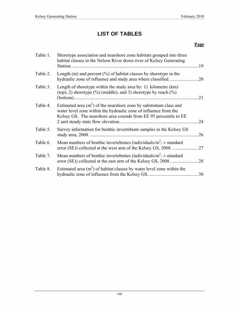
LIST OF TABLES
Page Table 1. Shoretype association and nearshore zone habitats grouped into three
habitat classes in the Nelson River down river of Kelsey Generating Station. ...........................................................................................................19
Table 2. Length (m) and percent (%) of habitat classes by shoretype in the hydraulic zone of influence and study area where classified. ........................20
Table 3. Length of shoretype within the study area by: 1) kilometre (km) (top), 2) shoretype (%) (middle), and 3) shoretype by reach (%) (bottom)..........................................................................................................21
Table 4. Estimated area (m2) of the nearshore zone by substratum class and water level zone within the hydraulic zone of influence from the Kelsey GS. The nearshore area extends from EE 95 percentile to EE 2 unit steady state flow elevation. ..................................................................24
Table 5. Survey information for benthic invertebrate samples in the Kelsey GS study area, 2008. ............................................................................................26
Table 6. Mean numbers of benthic invertebrates (individuals/m2; ± standard error (SE)) collected at the west arm of the Kelsey GS, 2008. ......................27
Table 7. Mean numbers of benthic invertebrates (individuals/m2; ± standard error (SE)) collected at the east arm of the Kelsey GS, 2008. .......................28
Table 8. Estimated area (m2) of habitat classes by water level zone within the hydraulic zone of influence from the Kelsey GS. ..........................................30

Kelsey Generating Station February 2010
ix
LIST OF FIGURES
Page Figure 1. Study reaches and the hydraulic zone of influence used for the Kelsey
GS Rerunnering Project, 2008. ......................................................................31
Figure 2. Fifty-one proposed priority and alternate cross section sites where water depth and elevation data was collected. Each cross-section represents two potential field transects on opposing sides of the river..........32
Figure 3. Habitat class and shoretype distribution for the study reaches including the Grass River, Kelsey GS West, Kelsey GS East, and the Nelson River reaches......................................................................................33
Figure 4. Habitat class and shoretype distribution for the Study Reaches including the Anipitapiskow Rapids, Downstream Anipitapiskow, Sakitowak West and Sakitowak East reaches. ...............................................34
Figure 5. Representative photos of habitat class A: representing embayment (1), stream mouth (2) and lowland deposition (3) shorezones. Note: macrophyte stands visible in photos. .............................................................35
Figure 6. Representative photos of habitat class B: upland fines (1) and lowland fines (2). ...........................................................................................36
Figure 7. Representative photos of habitat class C: shield (1), built-up (2) and upland aggregate (3) shorezones. Note lotic water mass and steep(er) topography......................................................................................................37
Figure 8. Surveyed transects (54). .................................................................................38
Figure 9. Benthic invertebrate sample locations............................................................39
Figure 10. Substratum composition of transects in the Grass River section. ..................40
Figure 11. Substratum composition of transects in the Kelsey GS West section............41
Figure 12. Substratum composition of transects in the Kelsey GS East section. ............42
Figure 13. Substratum composition of transects in the Nelson River section. ................43
Figure 14. Substratum composition of transects in the Anipitapiskow Rapids section. ...........................................................................................................44
Figure 15. Substratum composition of transects in the Sakitowak Rapids West section. ...........................................................................................................45
Figure 16. Substratum composition of transects in the Sakitowak Rapids East section. ...........................................................................................................46
Figure 17. Frequency of aquatic plant observations on silt, silt/clay or sand substrates with respect to EE/PP water zone levels. ......................................47

Kelsey Generating Station February 2010
x
Figure 18. Percent occupation of aquatic plants in transects in the Kelsey GS study area. ......................................................................................................48
Figure 19. Mean number of benthic invertebrates (individuals/m2) in transects in the west and east arms of the Kelsey GS study area. .....................................49
Figure 20. Abundance of benthic invertebrates sampled at various water depths in the west and east arms of the Kelsey GS study area. .................................49
Figure 21. Abundance of benthic invertebrates and elevation at four sampling locations in the west arm of the Kelsey GS study area. .................................50
Figure 22. Abundance of benthic invertebrates and elevation at three sampling locations in the east arm of the Kelsey GS study area. ..................................51
LIST OF APPENDICES
Appendix 1. North/South Consultants Inc. sample processing and quality assurance/quality control (QA/QC) procedures.......................................52
Appendix 2. Transect substrate composition................................................................55
Appendix 3. Raw numbers of benthic invertebrates collected in the Kelsey GS study area .................................................................................................58

Kelsey Generating Station February 2010
1
1.0 INTRODUCTION
Re-runnering will increase the discharge capacity of the Kelsey Generating Station (GS)
meaning for the same amount of high inflows, if there is a power demand, less flow would
be spilled and more would be passed through the GS after the re-runnering. Increasing the
capacity of the GS will increase the opportunity for cycling of the plant, i.e., for a certain
daily inflow, the amount of flow passing through the power house will be maximized during
on peak hours to meet the power demand and minimized during off peak hours to keep the
total daily flow volume balanced. Cycling in both the existing and re-runnered condition
could occur as changes from 2 to 7 generating units (or less); therefore, the analysis focussed
on the 2 to 7 unit range as a “worst case” scenario..
Currently, the range of water levels (from minimum to maximum river flows) downstream of
the station is just under 4 m. This range will remain the same post re-runnering. The range
that is routinely dewatered, i.e., within the 5th and 95th percentile flows, is approximately 3
m. This zone is referred to as the “intermittently exposed zone” (IEZ). Increasing the
capacity of the station will increase the potential frequency for water level changes within
the day, from approximately 27% of the time to 57% of the time, as cycling will be able to
occur at higher flows than is currently possible. In addition, the maximum elevation that can
be affected by cycling will be increased. Therefore, habitat that is now intermittently
exposed on a weekly or seasonal basis could be affected by water level changes within the
day post-project. Increasing the capacity of individual turbines will also increase the
minimum elevation that can potentially be affected by cycling, i.e., the entire elevation range
that can be affected by cycling will be shifted upwards such that some habitat that is
typically wetted will no longer be potentially dewatered by cycling. This upward shift of the
lower elevation potentially affected by cycling was only observed in these most recent
analyses and was not part of the earlier assessment reports. ).
Fisheries and Oceans Canada (DFO) has requested an estimate of the amount and type of
habitat affected by cycling, as well as the additional areas that will potentially be affected by
cycling post-project. At a meeting on February 11, 2008, Manitoba Hydro presented an
approach to DFO outlining how the required habitat quantification and description would be
conducted. DFO requested that detailed information on the proposed field program be
provided once planning had been completed. This information was provided at subsequent
meetings and final proposed locations for bathymetric and habitat transects were jointly
selected with DFO’s representative prior to the field surveys. This document provides the
results of the habitat analysis and supporting work (e.g., benthic invertebrate sampling).

Kelsey Generating Station February 2010
2
The work described in this document includes the following:
• Classification of the nearshore habitat and selection of transect locations;
• Collection of bathymetry at transects to permit calculation of water surface
elevations at selected river flows through the use of a hydrological model;
• Description of nearshore habitat at each transect location;
• Sampling of benthic invertebrates at selected low gradient locations where an
extensive area is potentially affected by periodic dewatering;
• Use of the hydraulic model to calculate areas potentially affected by cycling in
the existing environment and post re-runnering; and
• Providing a description of habitats potentially affected by cycling in the context
of the total habitat in the nearshore environment.
It should be noted that this analysis focuses on habitat that would be affected by potential cycling in the existing environment in comparison to habitat that would be affected by
potential cycling post re-runnering over the full range that could be used for cycling (2 to 7
units). In practice, cycling occurs to meet on peak power requirement or when it is
economical, and historically Kelsey has been operated in cycling mode for only a fraction of
the potential time and almost never over the full range (2 to 7 units). Water level changes
caused by cycling at the GS occur within the overall water level changes resulting from
seasonal and interannual variation in discharge of the Nelson River. During periods of high
or low flows outside the cycling range, the water levels downstream of the station are a
function of discharge in the Nelson River, rather than cycling at the GS..

Kelsey Generating Station February 2010
3
2.0 METHODS
Determination of aquatic habitat changes post re-runnering required three main areas of
enquiry:
4. Existing environment (EE) and post-project (PP) water depths and elevation were
required to differentiate areas that will undergo habitat modifications post project.
For example, water elevations were required to determine how much area would be
influenced by the Kelsey GS after re-runnering and to distinguish areas that would no
longer be influenced by GS operation;
5. The shorezone habitat needed to be described to produce classifications of nearshore
habitat types in order to quantify areas of habitat modification across the local
landscape level; and,
6. An understanding of the composition of the nearshore area in each of the habitat
types was required to describe potential effects to aquatic biota. Information on
composition included substrate classification, presence of macrophytes and, in
selected locations, benthic invertebrates.
Each are described in turn in sections 2.2, 2.3, and 2.4.
2.1 STUDY AREA
The study area encompasses the Nelson River and adjoining Grass River where water levels
are potentially affected by cycling at the Kelsey GS. This area is divided into six river
reaches, referred to as the Grass River (lower section only), Kelsey GS West, Kelsey GS
East, Nelson River, Sakitowak West, and Anipitapiskow Rapids (Figure 1). Two additional
reaches, Downstream Anipitapiskow and Sakitowak East are backwatered from Split Lake
and do not fall within the hydraulic zone of influence of cycling at the Kelsey GS. Data was
collected from these areas at the request of DFO. However, these areas were not included in
the total habitat areas that would be affected by cycling at the GS.
2.2 COMPARISON OF EXISTING AND POST-PROJECT WATER ELEVATIONS
2.2.1 Water Level Variations and Zones
Based on the results of the HEC-RAS model developed by Manitoba Hydro, re-runnering of
the GS will cause an upward shift in the zone of habitat potentially affected by daily water
level changes caused by cycling. Cycling can occur when flows are within the range of 2 to 7
units. In the existing environment, this corresponds to 428 to 1700 m3/s while post re-

Kelsey Generating Station February 2010
4
runnering this corresponds to 628 to 2212 m3/s. This upward shift will mean that the habitat
between the elevations wetted by flows 1700 m3/s to 2212 m3/s will potentially be affected
by cycling while habitat wetted by flows of 428 to 628 m3/s will no longer be subject to
cycling. Given that the habitat within the upper flow range falls within the intermittently
exposed zone (1700 m3/s to 2212 m3/s ), it is wetted on average only 55% of the time,
regardless of cycling.
Overall, in the existing environment, habitat wetted by flows of 428 to 1700 m3/s is
potentially subject to cycling 27% of the time while post re-runnering habitat wetted by
flows of 628 to 2212 m3/s will potentially be subject to cycling 57% of the time.
2.2.2 Water Depth and Elevation Field Survey
Water depth and elevation information needed to describe the habitat with respect to the
existing and post-project water regimes was collected by Manitoba Hydro’s Engineering
Surveys and Services at 51 cross-sections, each representing two potential field transects on
opposing sides of the river (Figure 2). Transects were selected by Manitoba Hydro,
North/South Consultants Inc., and DFO based on various criteria, including supplementing
the existing hydraulic model, sampling from a range of habitat types in the area, and
including low slope areas with potential macrophyte growth. At each transect site, depth of
water and water surface elevation was collected across the full river cross section. Elevation
of the river bed at each cross section was calculated by subtracting water depth from the
corresponding water surface elevation.
Using the HEC-RAS hydraulic model, Manitoba Hydro estimated the water surface elevation
and location of the water/land interface(shoreline) for the following conditions: 5th
percentile flow (891 m3/s), 95th percentile flow (3701 m3/s), existing environment 2 unit
flow (428 m3/s), existing environment 7 unit flow (1700 m3/s), post project 2 unit flow (628
m3/s) and post project 7 unit flow (2212 m3/s). The area of interest to this report lies between
the water levels of EE 2 unit flow and the water levels of EE 95th percentile flow, and is
defined here as the Nearshore Area (NSA).
2.3 SHOREZONE RECONNAISSANCE AND CLASSIFICATION
Aerial surveys were undertaken on July 7, 2008 using a Bell Jet Ranger helicopter and a
Nikon D200 digital camera with integrated Global Positioning System (GPS) data to capture
geographic location, elevation, date, and time in each photograph. Each of the 534 high
resolution digital images was taken about 75 – 100 m above the water surface from an
oblique aspect towards the shoreline.

Kelsey Generating Station February 2010
5
2.3.1 Shoretype Associations
Shoretype associations were developed using indicators such as geomorphology, soils,
shoreline configuration, and how water movements structure the availability of materials to
form habitat. Shoretype associations, unlike detailed maps of river bottom types that show
specific material distributions (e.g. gravel, cobble, sand), are more general interpretations of
habitat distributions at the local landscape level. Each shoretype was derived by review of
the shorezone photography (section 2.3), digital ortho images to interpret terrestrial terrain
(landcover), and the aquatic habitat transects (described in section 2.4 below).
The nearshore zone classification included consideration of the bank materials, the nearshore
substratum, whether within a lotic or lentic area, and whether or not the habitat had potential
for macrophyte growth.
For the purposes of describing functional habitat types, shoretype associations and near shore
zone classifications were aggregated into three classifications, each with similar habitat
characteristics are described below and mapped in Figures 3 and 4. The associations
between the shoretype, the nearshore zone and habitat class are defined for the study area are
described in Table 1.
Habitat Class A: The shorezone is characterized by lowland topography (low slopes),
abundant shrub understory, with predominantly fine-grained substrates composed of silt and
silt/clay, lentic water mass and good potential for the growth of macrophytes. Organic
matter may be present. Shoretypes are embayment, stream mouth and lowland deposition
(representative photos are shown in Figure 5).
Habitat Class B: The shorezone is characterized by low to moderate topography with
isolated bedrock outcrops. Substrates are composed of clay – silt/clay mixed or alternating
with sand to sand and gravel. Water mass is usually lentic with low to moderately low
potential for macrophyte growth. Slopes are moderate. Shoretypes are upland and lowland
fines (representative photos are shown in Figure 6).
Habitat Class C: The shorezone is composed of steep shield topography or coarse
glaciofluvial deposits with predominantly bedrock/boulder/cobble/gravel substrates. Sand
substrates may be present but are not common. Water mass is generally lotic and the

Kelsey Generating Station February 2010
6
potential for macrophytes is low. Shoretypes are shield, built-up (at Kelsey GS) and upland
aggregate (representative photos are shown in Figure 7).
2.4 NEARSHORE HABITAT SURVEY
An aquatic habitat survey was conducted to describe the habitat within the zone of water
level variation. Benthic invertebrate samples were collected at selected low gradient
locations where an extensive area is potentially affected by periodic dewatering. Detailed
methodology for this portion of the 2008 field program is provided below.
2.4.1 Physical Monitoring
Substrate typing and water depths (±0.1 m) were measured with a metered aluminum depth
rod. A Garmin Etrex® (GPS) receiver was used to record all sampling location coordinates
(Universal Transverse Mercator [UTM] NAD 83). A Trimble GPS Pathfinder® ProXRS,
using real-time differential corrections, was used to mark the start point, substrate transition,
vegetation presence, and end point coordinates along each transect. Access to all sampling
locations was by motorized boat.
2.4.2 Sampling Period and Locations
2.4.2.1 Substrate Transects
Substrate transects were surveyed 10 – 15 September, 2008. The substrate types and
vegetation (including attached algae) were described along 54 transects (Figure 8). Twelve
transects were located west of the Kelsey GS, in the Grass River. Seven transects were
located in the isolated bay east of the GS. Twenty-three transects were located in the Nelson
River mainstem due north of the GS, reaching past Anipitapiskow Rapids; and12 were
located in the eastward division of the Nelson River, just past Sakitowak Rapids.
2.4.2.2 Benthic Invertebrates
Sediment-dwelling macroinvertebrate populations tend to be more stable in the fall,
permitting the population to be better represented by samples collected during this time
period. Invertebrate sampling was conducted on 13 September, 2008 at two locations: one in
a vegetated bay to the west (west arm) of the GS, and the other in a bay to the east (east arm)
of the GS (Figure 9).

Kelsey Generating Station February 2010
7
2.4.3 Sample Collection and Field Measurements
2.4.3.1 Substrate Transects
Transects were measured in a perpendicular direction/orientation from the shoreline using
metered tape. Water depth was measured at 0.5 m intervals using a rod. At each 0.5 m
interval, the presence of vegetation/algae and substratum material was also assessed. GPS
coordinates were logged at each interval where a substrate type change and/or vegetation
presence change occurred and at the beginning and end of each transect. Transects were
terminated at 3.5 m water depth or at the point where the boat became entrained in fast
current.
GPS coordinates of transect start points were matched to HEC-RAS model shoreline points
for the Kelsey study area by Manitoba Hydro (K. Wong, pers. comm. June 4th, 2009).
2.4.3.2 Benthic Invertebrates
Benthic invertebrates were collected with a petite Ponar grab (0.023 m2 opening).
Invertebrate sampling was collected at various depth-sites at two transects located in the west
and east arms. The transect locations were established at the shoreline in each arm and based
on water depth/elevation. In the west arm, samples were collected at four depth-sites
(approximately 0.5 m; 2 m; 4 m; and 6 m); in the east arm, at three depth-sites
(approximately 2 m; 4 m; and 6 m). Five samples (replicates) were taken at each depth-site
to determine within-site benthic invertebrate variability. To ensure that disturbance from the
sampler would not affect the replicates, each one was taken from different points around the
boat (i.e., bow, stern, port, and starboard). Each benthic grab was sieved through a 400
micron sieve bucket and the sample contents were rinsed into a labelled container. Samples
were fixed in 10% formalin and shipped to the North/South Consultants laboratory
(Winnipeg, MB) for identification of invertebrates.
2.4.4 Laboratory and Data Analysis
2.4.4.1 Substrate Transects
In a GIS, transect lines were drawn from differentially corrected GPS start and end points for
each transect. Each transect line was divided into 0.5 metre segments, referred to as transect
segments, numbered in ascending order from shore. Each transect segment centroid was
buffered 5 metres laterally (each side) to generate polygons for aerial calculations of habitat
and to enable cartographic presentation of substrate material.

Kelsey Generating Station February 2010
8
Not all transects surveyed reached as far offshore as the EE 2 unit boundary at the lowest
extent of the Nearshore Zone. In such cases, the area of the transect between the limit of
data and the position of the EE 2 unit flow was left as “unclassified” in the mapping. As a
result, we refer to ‘surveyed transect segments’ as those with data, and ‘total segment
transects’ which also include the unclassified segments.
2.4.4.2 Calculating Habitat Areas by Water Levels under Different Flows
An estimate of the total area for each shoretype class by water level was needed to form the
basis for assessment. To do this, the proportion of each substrata in each transect was
calculated. In the case where several transects represented the same shoretype, proportions
were adjusted to reflect equal representation of each transect based on the frequency they
occurred. Proportions were adjusted to each represent a 1 m unit of shoreline length.
Proportions were then extrapolated to the all areas within the hydraulic zone of influence
based on each shoretype’s shoreline length.
It should be noted that only transects located within the hydraulic zone of influence were
used in area calculations. Also, three transects were not included in the habitat area
calculations due to absence of flow elevation points: DFO-P-5A, DFO-P-3B, and DFO-P-
1A.
2.4.4.3 Benthic Invertebrates
In Winnipeg, invertebrate samples were rinsed with water using a 500 micron test sieve,
transferred to 70% ethanol and sorted under a 3X desktop magnifier with lamp. Invertebrates
were identified to major group (subclass, order, or family); Chironomidae were identified to
subfamily. Samples were quantified by an invertebrate taxonomy technician. A Leica
Mz12.5 microscope (maximum 100X magnification) and reference texts from Merritt and
Cummins (1996), Peckarsky et al. (1990), and Clifford (1991) were used for identification.
Scientific names used followed the Integrated Taxonomic Information System (ITIS)
classification. Abundance of benthic invertebrates was calculated by dividing the total
number of invertebrates per sample by the area of the sampler (0.023 m2). Sample
processing, taxonomy, and quality assurance were completed in accordance with
North/South Consultants Inc. procedures (Appendix 1).

Kelsey Generating Station February 2010
9
3.0 RESULTS
3.1 EXISTING ENVIRONMENT AND POST PROJECT AREAL COMPARISON
In the existing environment, 2.18 km2 is estimated to be currently within the zone potentially
affected by cycling at the Kelsey GS (2-7 unit range with existing turbines). Post-project this
area is predicted to be 2.50 km2 (2-7 unit range with re-runnered turbines) for a difference of
0.32 km2. The value of this habitat is discussed in section 4.0. Cycling within this range can
potentially occur 27% of the time with the existing turbines and 57% of the time in the re-
runnered state.
3.2 SHOREZONE CLASSIFICATION
Approximately 74.2 km of shoreline was classified. Eight shoretypes were identified from
the aerial photography with limited sub-variation in nearshore zones were evident in the
transect data (see section 2.3.1).
The eight shoretypes were grouped into three habitat classes based on commonalities such as
substrate materials, slope, water mass (lentic or lotic), macrophyte growth potential,
topography, and depositional potential. The length and percentages of shoretypes in the
hydraulic zone of influence, the downstream reaches (Sakitowak East and Anipitapikow
Rapids) and the study area are shown in Table 2. Habitat class C (including shoretypes
Precambrian shield, built-up and upland aggregate) was the most common representing 47%
of the total study area. Habitat class B (shoretypes of lowland and upland fines) was least
common (26% of the shoreline length) and Class A containing embayment, stream mouth
and lowland depositional shorezones (which has the highest potential for the presence of
aquatic macrophytes), existed in 27% of the study area. In the hydraulic zone of influence,
habitat Class C was also the most common, comprising 45% of the total area, followed by
Class A (30%) and Class B (25%).
Analysis of the shoretype data by substrata class and study reach (Table 3) shows patterns of
habitat availability in the Study Area, as discussed below.
Habitat Class A
In the hydraulic zone of influence, habitat class A is most common in the Grass River and
Kelsey GS West reaches representing 47.5% of the class. The remainder of habitat class A
in the hydraulic zone of influence is located mainly in Kelsey GS East (14.2%), the Nelson
River reach (6.4%) and it is the least common in the Anipitapikow Rapids area (3.5%).

Kelsey Generating Station February 2010
10
By reach, about 90% of the Grass River reach is classified as Habitat Class A, followed by
the Kelsey GS West reach which contains a 40% proportion of this class. The lowest
proportions of Habitat Class A by reach are located in Anipitapiskow Rapids (2.7%),
Sakitowak West (3.4%). Outside the hydraulic zone of influence, Sakitowak East was 62%
habitat class A.
Lowland deposition shorezones are most common in the Grass River and the Kelsey GS
West reaches, where this shoretype represents 85% and 31% of the shore length in each
reach, respectively. These areas also had abundant rooted macrophyte distributions in the
hydraulic zone of influence at 22.4% and 12.9% of total observations respectively. Stream
mouth is widely distributed but most common in the Kelsey GS West with 33% of this type
located here comprising 12.1% of all macrophyte observations. Sakitowak west had 28.9%
of all plant observations concentrated in relatively small areas of lowland deposition (and
also on upland fines where favourable microhabitats such as silt – silt/clay substrates and
lentic water mass were present). Outside the hydraulic zone of influence, the majority of
embayment shorezones are located in Downstream Anipitapiskow Rapids reach (63.6%)
which makes up almost 37% of this area.
Habitat Class B
Habitat Class B is well distributed throughout the study area with over 30% of it located in
Sakitowak West; it is least common in Grass River (2.3%) and Kelsey GS West (3%). More
than half (53.9%) of the Upland Fine shoretype is found in the Sakitowak West reach due
mainly to a well developed glacio-fluvial deposit found along the south shore. Lowland Fine
shoretypes are most common downstream of Anipitapiskow Rapids (30% of this reach)
followed by the Nelson River (22.6% of this reach).
Habitat Class C
Kelsey GS East contains the largest percentage of Habitat Class C (44.9%) with the
remainder distributed approximately evenly in all reaches excepting Grass River. The Shield
shoretype is widely available although almost 60% of this shoretype is found in the Kelsey
GS East, Kelsey GS West and Nelson River reaches. Boulder/Cobble shorelines
representative of the Upland Aggregate shoretype are not abundant in the study area but
about one-third (31%) of that available is found downstream of Anipitapiskow Rapids.
Almost 29% of the bedrock in the Study Area is found in Kelsey GS East. As expected, the
Built-up shoretype is found only in the area near to Kelsey GS and accounts for 13.5% of the
shore length in the Kelsey GS East reach.

Kelsey Generating Station February 2010
11
3.3 NEARSHORE TRANSECTS
The boat-based surveys for aquatic habitat, aquatic plants and benthic invertebrates were
done during a period of very high flows, permitting access to areas that are often not wetted.
The preceding period was also generally characterized by flows well above median levels,
which began in 2005 and continued through 2008 (Environment Canada, 2009), which
would affect the distribution of plants and benthic invertebrates, as discussed below.
Fifty-four transects were surveyed in the nearshore zone of the Grass and Nelson rivers
which resulted in 3,610 observations of nearshore zone habitat. A summary of substrate
proportions by transect is located in Appendix 2, including percent occupancy of aquatic
plants.
The nearshore area, which includes water levels for flows from 428 m3/s to 3,701 m3/s,
within the hydraulic zone of influence is approximately 3.74 km2 or 374 ha (Table 4). Data
on bottom type was collected (i.e. at sites less than 3.5 m water depth or less than 100 m
distance from shore) on 71.9% of the total transect distance, which is about 2.7 km2 or 269
ha of the Nearshore Zone.
The offshore end of the nearshore transects where classification was difficult was most
notable on the Built-up, Shield, and Upland Aggregate shoretypes that are relatively steep
and water is flowing. In these shoretypes the nearshore estimates of the unclassified bottom
type range from 46 – 69% of the nearshore. Fortunately, these swift lotic habitats tend to
have fewer habitat transitions so the observations made in the shallows are expected to be
similar at greater depth.
Depositional substrata dominate the stream mouth, lowland deposition and embayment,
shoretypes where silt or silt/clay substrata account for 99%, 78% and 65% of the nearshore
area by shoretype, respectively.
Lowland fine and Upland Fine nearshore area have a greater proportion of sand than the
predominantly depositional shoretypes. In both shoretypes, sand and clay each occupies
about equal proportions in the range of 28- 29%. Depositional areas in the Lowland Fine
and Upland Fine NSA composed of clay would be considered a microhabitat in this
Shoretype. The available data do not suggest that the deposition microhabitat is scattered
heterogeneously within the NSA of this shoretype, but instead where deposition is found it is
locally homogeneous. Therefore, the availability of clay depositional areas in the study area
varies by shoretype but when present, the characteristics of all clay deposition areas are
generally similar.

Kelsey Generating Station February 2010
12
3.4 AQUATIC PLANTS
Over 95% of the aquatic plants were found on silt or silt/clay and less commonly on sand
substrates. Aquatic plants were most plentiful (just under 50% of total observations) on the
Grass River and in Kelsey GS West reaches, occupying up to 50% of each transect,
particularly on the south shore. Aquatic plants also occupied two bay areas of the west shore
of the Nelson River and the reach upstream of Sakitowak Rapids west in high but locally
concentrated proportions (up to 80% of three transects; Figure 15). Plants in the Sakitowak
Rapids West reach, accounted for over 28% of total observations.
Low or no presence of plants was noted on most mainstem Nelson River sites and in the east
arm where substrates tended to be dominated by sand, gravel, boulder and bedrock materials
(excepting bays where aquatic plants were observed in variable proportions which account
for the remainder of the total observations; Figure 13). The percent occupancy by transect of
aquatic plants is provided in Appendix 2.
Of all plants located on silt to silt/clay or sand substrates, almost 95% were located above the
5th percentile of flow. Submergent aquatic plants typically do not tolerate dewatering;
however, the prolonged period of high flows has likely resulted in an upward shift in rooted
macrophyte distribution in the shore zone. Just under 30% of observations of plants were
located in areas wetted by flows greater than 2,212 m3/s, at which spilling occurs in both EE
and PP environments. These areas are note expected to be vegetated under more typical flow
conditions. The flow range 1,700 – 2,212 m3/s contained 23.5% of all observed
macrophytes, and 42.6% were observed in the range between the 5th percentile and EE 7 unit
or between 891 and 1,700 m3/s flows (Figure 17). Figure 18 displays the distribution of
occupation throughout the study area.
3.5 BENTHIC INVERTEBRATES
Five benthic grab replicates were collected at each of four sampling locations in the west arm
and three sampling locations in the east arm of the Kelsey GS (Table 5, Figure 9 and
Appendix 3). The distribution of benthic invertebrates was similar across the depth range,
considering variation among replicates, with the exception of one sample in the west arm
(#3). The exceptionally low abundance in this sample resulted in a lower overall invertebrate
abundance within the west arm (Table 7). Mean total invertebrate abundance was 2,852 and
4,026 individuals/m2 in the west and east arms, respectively (Table 6). Insecta, primarily
Chironomidae and Ephemeroptera, was the most abundant invertebrate group in both the east
and west arms, followed by Crustacea and Mollusca (tables 6 and 7).

Kelsey Generating Station February 2010
13
With the exception of the one anomalous sample previously mentioned, total invertebrate
abundance increased with increasing water depth and was greatest in the deepest samples in
both the east and west arms (tables 6 and 7, Figure 20). Overall, insect abundance was
similar at all depths in the east arm and was variable in the west arm. However,
Chironimidae were most abundant in shallower samples and Trichoptera were most abundant
in deep samples in both the east and west arms. Ephemeropteran abundance was greatest at
mid and deep depths. Bivalvia, predominately Pisidiidae, and Crustacea were more abundant
in deep samples while Annelida abundance was greatest in shallow samples in both the east
and west arms (tables 6 and 7).
Elevation data were not available for the benthic invertebrate sampling sites, therefore, data
were extrapolated from nearby habitat transects: Site DFO-P-4B for the west arm and Site
DFO-P-2B for the east arm. Invertebrate samples collected at depths equal to or shallower
than 2.1 m fell within the intermittently exposed zone (IEZ) and sites at 2.1 m of depth were
within both the PP 2-7 and EE 2-7 unit zones in both the east and west arms (Figures 21 and
22). Invertebrate abundance within the IEZ may have been elevated in 2008 due to high
water conditions prevailing since 2005. Samples collected at depths greater than 3.9 m were
below the elevation range potentially affected by cycling in either the EE or PP . The highest
invertebrate abundance in both the east and west arms occurred at the deepest sites, i.e.,
within the permanently wetted zone (below EE 2 unit flows) (Figures 21 and 22).

Kelsey Generating Station February 2010
14
4.0 EFFECTS ASSESSMENT
4.1 VALUATION AND QUANTIFICATION OF HABITAT LOSS OR GAIN
The flow zone 1,700 – 2,212 m3/s, which is potentially subject to cycling post-project and is
not subject to cycling in the existing environment, amounts to an area of 453,046 m2 or 0.45
km2 (Table 8). This area is located in the intermittently exposed zone, and on average
habitat in this area is estimated to be wetted 55% of the time. Therefore the productive
aquatic habitat was adjusted to 0.55% of the total area, which represents 249,175 m2 or 0.25
km2. It should be noted that although 23.5% of the total macrophyte observations were
located within this flow range, conditions of high flows over the past number of years would
have increased macrophyte growth within this range. It is expected that macrophyte growth
would substantially decrease with a return to more typical flow conditions, regardless of
changes in cycling.
As discussed in section 3.5, it is expected that the higher benthic populations noted in
relatively shallower ranges (within the IEZ) are the result of inundation over a number of
years due to a prolonged period of high flows in the Nelson River (independent of the
operations of the GS). Typically, in regulated reservoirs and below hydroelectric dams,
fluctuating water levels result in lower invertebrate abundance in the intermittently exposed
area with maximum abundance occurring below this exposure limit, within the permanently
wetted the portion of the reservoir or watercourse (Armitage 1977; Fillion 1967; Fisher and
Lavoy 1972; Janicki and Ross 1982). This pattern was observed in the nearshore of
Wuskwatim Lake, MB, where benthic invertebrate abundance in the intermittently exposed
zone was approximately 50% that of nearby permanently wetted habitats, when this habitat
was re-wetted for a full growing season after having been dewatered the previous growing
season (Manitoba Hydro and NCN 2003). Assuming, therefore, that habitat periodically
exposed for longer periods (e.g., a growing season) would support only 50% of the
production of permanently wetted habitat during periods when it is wetted, the productive
capacity of the 249,175 m2 or 0.25 km2 of habitat would be equivalent to 124,587 m2 or 0.12
km2 of permanently wetted habitat
The effect of periodic exposure depends on the substrate quality as well as the frequency and
duration of exposure. The re-runnering project would potentially increase the frequency of
exposure within the day, but not affect exposure due to longer term changes in water levels
(e.g., seasonal variations), which are controlled by outflow from Lake Winnipeg. Typically,
Chironomidae and Oligochaeta are able tolerate the conditions of periodic exposure
(dessication, freezing) in the upper littoral zone as well as be able to rapidly take advantage

Kelsey Generating Station February 2010
15
of newly wetted habitat, capable of colonizing bare substrates within a month (Fisher and
Lavoy 1972; Scheifhacken et al. 2007). The quality of the intermittently exposed area is also
influenced by the type of substrate affected by water level fluctuation; mineral-based
substrate tends to freeze solid to some depth (hence, degraded quality for benthic
invertebrates), whereas organic-based substrate freezes only at the surface, if at all, and also
remains moist during intermittent exposure (hence, better quality for benthic invertebrates)
(Koskenniemi 1994). In the Kelsey Study Area, Oligochaeta and Chironomidae, in
particular, were proportionately more abundant in the intermittently exposed range (tables 6
and 7). Additionally, the qualitative substrate characterization at benthic invertebrate
sampling locations indicates predominance of organic material within the intermittently
exposed area of the west arm and across all sampling locations in the east arm (Table 5).
Therefore, conditions in the IEZ would make the invertebrate community relatively more
resistant to the effects of the daily water level changes that could occur more frequently post
re-runnering.
To summarize, the nature of the effect post project in the zone between 1,700 to 2,212 m3/s,
which is where re-runnering would potentially cause an increase in cycling within the day,
may negatively affect the equivalent of 0.12 km2 of permanently wetted habitat; however, the
actual effect may be negligible due to the duration of exposure and conditions within this
zone.
The flow zone between 628 and 1,700 m3/s, common to both EE and PP 2-7 units, amounts
to 2,051,377 m2 or 2.05 km2 in area. The most productive habitat in this range, habitat class
A, accounts for 36% of this area or 749,640 m2 or 0.75 km2. Habitat classes B and C in this
flow range are considered to be of lower value due to their general lack of macrophyte
habitat and lower suitability for benthic invertebrates. This area is estimated to be subject to
potential cycling 27% of the time in the existing environment and potential cycling 57% of
the time in the post project period. Changes in cycling in this flow range could amount to a
net increase in the frequency of cycling by 30%. Assuming a uniform distribution of cycling
over time in the existing and post-project periods, this increase in the frequency of cycling
would not be expected to have a detectable effect on productivity since the negative effects
of cycling (e.g., dewatering of macrophyte habitat preventing plant growth) would already
occur under the 27% cycling scenario. Therefore, a neutral effect to habitat productivity is
assessed for this flow range.
The 428-628 m3/s flow zone exclusive to the EE 2-7 will no longer be potentially subject to
cycling post project. This area accounts for an area of 132, 293 m2 or 0.13 km2. This area is
of nominal value to macrophytes but higher populations of benthic invertebrates were

Kelsey Generating Station February 2010
16
observed in this range than in any other flow range and therefore this area is considered a
high value net habitat gain.
Given a potential decrease in the production within 0.12 km2 of habitat (presented as
equivalent to permanently wetted habitat) in the flow zone between 1,700 – 2,212 m3/s, a
neutral effect in the flow zone between 628 and 1,700 m3/s and a potential gain in production
within 0.13 km2 in the 428-628 m3/s flow zone, a net productive gain within 0.01 km2 of
habitat is estimated post project. It should be noted that the reduction in production in the
1,700 – 2,212 m3/s zone may be negligible given the short term duration of dewatering, and
site-specific characteristics of the substrate and benthic invertebrate community.

Kelsey Generating Station February 2010
17
5.0 REFERENCES
ARMITAGE, P. 1977. DEVELOPMENT OF THE MACRO-INVERTEBRATE FAUNA OF COW GREEN RESERVOIR (UPPER TEESDALE) IN THE FIRST FIVE YEARS OF ITS EXISTENCE. FRESHW. BIOL. 7: 441-454.CLIFFORD, H.F. 1991. Aquatic invertebrates of Alberta. The University of Alberta Press: Alberta. 538 pp.
ENVIRONMENT CANADA, 2009. Water Survey of Canada, Archived Hydrometric Data. Available: http://www.wsc.ec.gc.ca/hydat/H2O/index_e.cfm?cname=WEBfrmDailyReport_e.cfm
FILLION, D. 1967. The abundance and distribution of benthic fauna of three mountain reservoirs on the Kananaskis River in Alberta. J. Appl. Ecol. 4: 1-11.INTEGRATED TAXONOMIC INFORMATION SYSTEM (ITIS). 2009. Available : www.itis.usda.gov.
FISHER, S.G. and LAVOY, A. 1972. Differences in littoral fauna due to fluctuating water levels below a hydroelectric dam. J. Fish. Res. Board Ca. 29: 1472-1476.
JANICKI, A.J. and R.N. ROSS. 1982. Benthic invertebrate communities in the fluctuating riverine habitat below Conowingo Dam. A report prepared for the Power Plant Siting Program of the Maryland Department of Natural Resources by the Martin Marietta Environmental Center. 36 pp.
KOSKENNIEMI, E. 1994. Colonization, succession and environmental conditions of the macrozoobenthos in a regulated, polyhumic reservoir, Western Finland. Int. Revue ges. Hydrobiol. 79: 521-555.
MANITOBA HYDRO and NISICHAWAYASHIK CREE NATION. 2003. Wuskwatim Generation Project environmental impact statement. Volume 5.
MERRITT, R.W. and K.W. CUMMINS. 1996. An introduction to the aquatic insects of North America. 3rd edition. Kendall/Hunt Publishing Co.: Iowa. 862 pp.
PECKARSKY, B.L., P. R. FRAISSINET, M.A. PENTON, and D.J. CONKLIN JR. 1990. Freshwater macroinvertebrates of northeastern North America. Cornell University Press: New York. 442 pp.
SCHEIFHACKE, N., C. FIEK, and K.-O. ROTHHAUPT. 2007. Complex spatial and temporal patterns of littoral benthic communities interacting with water level fluctuations and wind exposure in the littoral zone of a large lake. Fundamental and Applied Limnology. 169: 115-129.
Personal Communications Cited
Karen Wong. 2009. Manitoba Hydro, Winnipeg Manitoba.

Kelsey Generating Station February 2010
18
TABLES AND FIGURES

Kelsey Generating Station February 2010
19
Table 1. Shoretype association and nearshore zone habitats grouped into three habitat classes in the Nelson River down river of Kelsey Generating Station.
Shoretype Associations
Shoretype Name Shoretype Nearshore zone Habitat Class
Embayment Localized lowland topography with abundant understory species, emergent plants may be found in shorezone
Predominantly fine grained - typically clay, organic matter may be present, low slope, overlying water mass is lentic, macrophytes may be present A
Stream Mouth Lowland topography with abundant shrub understory species, emergent plants in shorezone
Predominantly silt/clay based, low slope, organic matter or detritus may be present, overlying water mass is lentic, macrophytes may be present A
Lowland Deposition Lowland topography with abundant shrub understory species, emergent plants in shorezone
Nearshore zone predominantly silt/clay, low slope, overlying water mass is lentic, macrophytes may be present
A
Upland Fine Moderate relief topography with deciduous and/or conifer overstory, overlying fine glaciolacustrine deposit
Bank is typically clay or silt/clay based, moderate slope, much of nearshore zone sandy with patches of gravel and deposition, overlying watermass is usually lentic, macrophytes may be present
B Lowland Fine Lowland topography with abundant shrub understory species,
isolated bedrock outcrops and potential for emergent plants in shorezone
Nearshore zone sandy in shallow water, sand and gravel may be present or associated with infrequent bedrock outcrops, low to moderate slope, silt/clay bottom in patches or below sand, overlying water mass is lentic B
Sheild Shield topography with well drained soils, deciduous and/or
conifer overstory, overlying bedrock parent material; shorezone predominantly bedrock
Predominantly bedrock, sand may be present and alternate with undulations in bedrock, moderate to high slope river bed, overlying water mass usually lotic or if lentic is proximate the lotic habitat
C Built-Up Built up topography with abundant bedrock and/or blast rock
shorezone predominantly bedrock/blast rock Predominantly bedrock/blast rock, overlying water mass is lotic
C Upland Aggregate Upland topography with well drained soils, deciduous and/or
conifer overstory, overlying coarse glaciofluvial deposit Predominantly boulder/cobble/gravel, infrequent bedrock outcrops, moderate slope, overlying watermass is usually lotic
C

Kelsey Generating Station February 2010
20
Table 2. Length (m) and percent (%) of habitat classes by shoretype in the hydraulic zone of influence and study area where classified.
Habitat Class Shoretype
Hydraulic Zone of
Influence
% of Hydraulic
Zone of Influence
Downstream reaches (Sakitowak East and
downstream Anipitapiskow Rapids)
% of Downstream
Reaches Total Length (m)
(Study Area) % Study Area Embayment 6,250 10 1,064 8 7,314 10
Stream Mouth 3,979 6 60 0 4,039 5 Lowland
Deposition 8,282 13 589 5 8,871 12
CLASS A
TOTAL 18,511 30 1,713 13 20,224 27
Lowland Fine 9,427 15 1,253 10 10,683 14
Upland Fine 6,014 10 2,678 21 8,378 12 CLASS B
TOTAL 15,411 25 3,391 31 19,061 26
Shield 20,729 34 4,992 39 30,399 35
Built Up 1,692 3 0 0 1,692 2
Upland Aggregate 5,116 8 2,081 16 12,234 10 CLASS
C
TOTAL 27,537 45 7,073 56 44,325 47
ALL 61,490 100 12,717 100 74,206 100

Kelsey Generating Station February 2010
21
Table 3. Length of shoretype within the study area by: 1) kilometre (km) (top), 2) shoretype (%) (middle), and 3) shoretype by reach (%) (bottom).
Shoretype Anipitapiskow
Rapids
Down Stream Anipitapiskow
Rapids Grass River
Kelsey GS East
Kelsey GS West
Nelson River
Sakitowak East
Sakitowak West Total
Embayment - 4651.5 - 1288.2 309.8 - 1064.3 - 7313.8
Stream_Mouth 60.1 605.9 222.8 1337.3 676.2 808.4 - 328.5 4039.1
Lowland_Deposition 588.9 - 4149.3 - 3439.4 384.2 - 309.3 8871.1
Total Habitat Class A 649.0 5,257.4 4,372.1 2,625.5 4,425.4 1,192.6 1,064.3 637.8 20,224.0
Lowland_Fine 1253.1 3793.3 490.6 625.3 1460.9 1976.2 - 1081.0 10680.4
Upland_Fine 994.5 - - - 696.9 628.0 1683.2 4689.1 8691.7
Total Habitat Class B 2,247.6 3,793.3 490.6 625.3 2,157.8 2,604.2 1,683.2 5,770.1 19,372.1
Shield 2436.0 1277.6 - 7408.5 4182.0 3763.9 2556.0 4097.3 25721.4
Built_Up - - - 1692.3 - - - - 1692.3
Upland_Aggregate 350.7 2271.9 - 212.2 376.5 1168.4 1729.8 1086.8 7196.3
Total Habitat Class C 2,786.7 3,549.5 0.0 9,313.0 4,558.5 4,932.3 4,285.8 5,184.1 34,610.0
Total 5,683.3 12,600.2 4,862.7 12,563.8 11,141.7 8,729.1 7,033.3 11,592.0 74,206.1

Kelsey Generating Station February 2010
22
Table 3. Continued.
Shoretype Anipitapiskow
Rapids
Down Stream Anipitapiskow
Rapids Grass River
Kelsey GS East
Kelsey GS West
Nelson River
Sakitowak East
Sakitowak West Total
Embayment - 63.6 - 17.6 4.2 - 14.6 - 100.0
Stream_Mouth 1.5 15.0 5.5 33.1 16.7 20.0 - 8.1 100.0
Lowland_Deposition 6.6 - 46.8 - 38.8 4.3 - 3.5 100.0 Average % Habitat Class A 2.7 26.2 17.4 16.9 19.9 8.1 4.9 3.9 100.0
Lowland_Fine 11.7 35.5 4.6 5.9 13.7 18.5 - 10.1 100.0
Upland_Fine 11.4 - - - 8.0 7.2 19.4 53.9 100.0 Average % Habitat Class B 11.6 17.8 2.3 3.0 10.9 12.9 9.7 32.0 100.0
Shield 9.5 5.0 - 28.8 16.3 14.6 9.9 15.9 100.0
Built_Up - - - 100.0 - - - - 100.0
Upland_Aggregate 4.9 31.6 - 2.9 5.2 16.2 24.0 15.1 100.0 Average % Habitat Class C 4.8 12.2 0.0 43.9 7.2 10.3 11.3 10.3 100.0

Kelsey Generating Station February 2010
23
Table 3. Continued.
Shoretype Anipitapiskow
Rapids
Down Stream Anipitapiskow
Rapids Grass River
Kelsey GS East
Kelsey GS West
Nelson River
Sakitowak East
Sakitowak West
Embayment - 36.9 - 10.3 2.8 0.0 15.1 0.0
Stream_Mouth 1.1 4.8 4.6 10.6 6.1 9.3 0.0 2.8
Lowland_Deposition 10.4 - 85.3 - 30.9 4.4 0.0 2.7
Total Habitat Class A 11.4 41.7 89.9 20.9 39.8 13.7 15.1 5.5
Lowland_Fine 22.0 30.1 10.1 5.0 13.1 22.6 0.0 9.3
Upland_Fine 17.5 0.0 0.0 0.0 6.3 7.2 23.9 40.5
Total Habitat Class B 39.5 30.1 10.1 5.0 19.4 29.8 23.9 49.8
Shield 42.9 10.1 0.0 59.0 37.5 43.1 36.3 35.3
Built_Up 0.0 0.0 0.0 13.5 0.0 0.0 0.0 0.0
Upland_Aggregate 6.2 18.0 0.0 1.7 3.4 13.4 24.6 9.4
Total Habitat Class C 49.1 28.1 0 74.2 40.9 56.5 60.9 44.7 Total 100.0 100.0 100.0 100.0 100.0 100.0 100.0 100.0

Kelsey Generating Station February 2010
24
Table 4. Estimated area (m2) of the nearshore zone by substratum class and water level zone within the hydraulic zone of influence from the Kelsey GS. The nearshore area extends from EE 95 percentile to EE 2 unit steady state flow elevation.
Shoretype Substratum
> 2,212 m3/s
(spilling EE and PP)
1,700-2,212 m3/s (PP 2-
7 Unit)
PP 2-7 and EE 2-7 Unit
(>5th Percentile)
PP 2-7 and EE 2-7 Unit
(<5th Percentile)
428-628 m3/s (EE 2-
7 Unit) Total Built Up boulder 3386.6 2634.0 0.0 0.0 0.0 6020.6
organic 376.3 0.0 0.0 0.0 0.0 376.3
sand 3010.3 0.0 0.0 0.0 0.0 3010.3
unclassified 0.0 1505.1 10535.9 3010.4 1505.1 16556.6
Built Up Total 25,963.8 Embayment bedrock 0.0 0.0 21652.0 0.0 0.0 21652.0
boulder 7160.1 7103.0 14207.1 0.0 0.0 28470.2
clay 541309.7 0.0 64956.8 0.0 0.0 606266.5
organic 21310.4 0.0 163379.1 0.0 0.0 184689.5
sand 39695.1 0.0 43305.2 0.0 0.0 83000.3
unclassified 0.0 0.0 3551.3 0.0 0.0 3551.3 Embayment
Total 927,629.8 Lowland Deposition bedrock 1741.2 1259.7 3347.0 0.0 0.0 6347.8
boulder 1424.3 0.0 979.5 0.0 0.0 2403.8
clay 40877.4 52056.8 127700.7 35471.2 7163.2 263269.3
clay/cobble 133.2 0.0 0.0 0.0 0.0 133.2
gravel 0.0 0.0 0.0 14690.7 2448.5 17139.2
sand 315.0 0.0 1889.6 1049.3 0.0 3253.9
unclassified 157.2 0.0 18940.9 14809.1 10159.4 44066.5 Lowland
Deposition Total 336,613.6
Lowland Fine bedrock 19472.2 15265.4 17910.8 668.2 0.0 53316.5
boulder 1217.7 304.3 1217.1 0.0 0.0 2739.1
clay 44888.0 30117.4 54510.3 5075.2 1903.3 136494.2
clay/boulder 608.4 304.3 304.3 0.0 0.0 1217.0
clay/cobble 0.0 304.3 0.0 0.0 0.0 304.3
cobble 0.0 1825.6 608.4 0.0 0.0 2434.0
sand 6849.5 19545.1 53783.7 58075.9 1388.0 139642.1
sand/cobble 0.0 2672.5 0.0 722.1 0.0 3394.6
unclassified 5396.8 10401.5 23860.9 47556.6 51729.8 138945.6 Lowland Fine
Total 478,487.4 Shield bedrock 90643.9 16688.8 26082.0 0.0 0.0 133414.8
boulder 48073.2 11701.4 12898.1 3485.3 1027.7 77185.6
clay 13293.3 16658.7 79424.8 0.0 954.0 110330.8
cobble 1429.9 4414.6 3854.2 0.0 0.0 9698.7
organic 912.9 0.0 0.0 0.0 0.0 912.9
sand 39441.6 3798.7 52482.4 1027.6 0.0 96750.3
unclassified 102412.4 86096.6 127356.1 45202.3 15983.7 377051.1
Shield Total 805,344.1

Kelsey Generating Station February 2010
25
Table 4. Continued.
Shoretype Substratum
> 2,212 m3/s
(spilling EE and PP)
1,700-2,212 m3/s (PP 2-
7 Unit)
PP 2-7 and EE 2-7 Unit
(>5th Percentile)
PP 2-7 and EE 2-7 Unit
(<5th Percentile)
428-628 m3/s (EE 2-
7 Unit) Total Stream Mouth clay 0.0 50392.8 199553.5 20157.0 8063.0 278166.2
unclassified 0.0 2016.0 0.0 0.0 0.0 2016.0 Stream Mouth
Total 280,182.3 Upland Aggregate bedrock 1550.7 5250.7 3500.1 0.0 0.0 10301.6
boulder 1551.0 11254.3 6203.0 0.0 0.0 19008.3
clay 25809.0 5249.4 0.0 0.0 0.0 31058.5
sand 10855.3 45969.1 6801.3 0.0 0.0 63625.7
unclassified 5250.6 0.0 145593.6 121977.8 11653.0 284474.9 Upland
Aggregate Total 408,469.0
Upland Fine bedrock 0.0 1899.6 9072.9 0.0 0.0 10972.5
boulder 0.0 0.0 598.5 2394.1 0.0 2992.6
clay 20794.5 23793.9 93912.1 3223.8 1934.2 143658.6
cobble 0.0 0.0 1804.0 1804.1 0.0 3608.1
sand 8997.4 22562.6 81965.2 17707.4 6158.2 137390.9
sand/cobble 0.0 0.0 598.4 0.0 0.0 598.4
unclassified 0.0 0.0 122593.5 52334.7 10222.3 185150.5 Upland Fine
Total 484,371.5 Grand Total (m2) 1,110,345.0 453,046.2 1,600,934.2 450,442.6 132,293.6 3,747,061.5 Grand Total (Ha) 111.0 45.3 160.1 45.0 13.2 374.7 Grand Total (%) 29.6 12.1 42.7 12.0 3.5 100

Kelsey Generating Station February 2010
26
Table 5. Survey information for benthic invertebrate samples in the Kelsey GS study area, 2008.
UTM (14U) Water Location Sample Replicate Date
Easting Northing Substrate Depth
(m) West Arm 1 1 13-Sep 651570 6213395 clay/organic 0.4 2 13-Sep 651570 6213395 clay/organic 0.4 3 13-Sep 651570 6213395 clay/organic 0.8 4 13-Sep 651570 6213395 clay/organic 0.8 5 13-Sep 651570 6213395 clay/organic 0.6 2 1 13-Sep 651559 6213406 clay/mud/pebbles 1.9 2 13-Sep 651559 6213406 clay/mud/pebbles 2.2 3 13-Sep 651559 6213406 organic 2.0 4 13-Sep 651559 6213406 organic 2.2 5 13-Sep 651559 6213406 organic 2.0 3 1 13-Sep 651547 6213461 clay balls 3.8 2 13-Sep 651547 6213461 clay balls 3.9 3 13-Sep 651547 6213461 clay balls 4.1 4 13-Sep 651547 6213461 clay balls 4.0 5 13-Sep 651547 6213461 clay balls 3.9 4 1 13-Sep 651529 6213522 clay balls/shells 5.8 2 13-Sep 651529 6213522 clay balls/shells 6.3 3 13-Sep 651529 6213522 clay balls/shells 5.2 4 13-Sep 651529 6213522 clay balls/shells 6.6 5 13-Sep 651529 6213522 clay balls/shells 7.9 East Arm 1 1 13-Sep 656131 6213590 clay/organic 2.0 2 13-Sep 656131 6213590 clay/organic 2.1 3 13-Sep 656131 6213590 clay/organic 2.2 4 13-Sep 656131 6213590 clay/organic 2.1 5 13-Sep 656131 6213590 clay/organic 2.2 2 1 13-Sep 655653 6213595 clay/detritus 4.5 2 13-Sep 655653 6213595 clay/detritus 4.7 3 13-Sep 655653 6213595 clay/detritus 4.4 4 13-Sep 655653 6213595 clay/detritus 4.7 5 13-Sep 655653 6213595 clay/detritus 4.5 3 1 13-Sep 655654 6213606 clay/organic/wood/detritus 6.6 2 13-Sep 655654 6213606 clay/organic/wood/detritus 6.4 3 13-Sep 655654 6213606 clay/organic/wood/detritus 6.2 4 13-Sep 655654 6213606 clay/organic/wood/detritus 6.8 5 13-Sep 655654 6213606 clay/organic/wood/detritus 6.6 4 1 bedrock - no sample 2.0 2 bedrock - no sample 4.0 3 bedrock - no sample 6.0

Kelsey Generating Station February 2010
27
Table 6. Mean numbers of benthic invertebrates (individuals/m2; ± standard error (SE)) collected at the west arm of the Kelsey GS, 2008.
Location West Arm Sample 1 2 3 4 Overall Mean SE Mean SE Mean SE Mean SE Mean SE Number of replicates/sample 5 5 5 5 20
Depth (m) 0.6 0.1 2.1 0.1 3.9 0.1 6.4 0.5 Annelida Oligochaeta 739 406 122 42 0 0 9 9 217 234 Hirudinea 9 9 0 0 0 0 0 0 2 4 Total Annelida 748 414 122 42 0 0 9 9 220 238 Crustacea Amphipoda (unidentified) 0 0 0 0 0 0 0 0 0 0 Haustoriidae 0 0 0 0 235 79 922 263 289 214 Talitridae 157 126 0 0 0 0 0 0 39 66 Total Crustacea 157 126 0 0 235 79 922 263 328 213 Mollusca Bivalvia (unidentified) 0 0 9 9 0 0 0 0 2 4 Pisidiidae 0 0 26 17 9 9 209 102 61 62 Gastropoda (unidentified) 0 0 113 113 9 9 0 0 30 56 Hydrobiidae 104 17 243 83 35 16 26 17 102 57 Physidae 96 42 0 0 0 0 0 0 24 27 Planorbidae 43 27 17 17 0 0 0 0 15 17 Valvatidae 17 17 26 17 9 9 0 0 13 13 Total Mollusca 261 64 435 119 61 22 235 102 248 99 Platyhelminthes 0 0 0 0 0 0 0 0 0 0 Insecta Hemiptera Corixidae 17 11 0 0 9 9 17 11 11 9 Ephemeroptera Caenidae 35 25 61 61 0 0 0 0 24 32 Ephemeridae 26 17 104 11 304 53 2122 505 639 459 Trichoptera (unidentified) 0 0 9 9 26 26 0 0 9 14 Hydropsychidae 0 0 0 0 0 0 0 0 0 0 Leptoceridae 0 0 35 16 43 34 330 83 102 74 Molannidae 9 9 17 11 0 0 0 0 7 7 Phryganeidae 26 17 0 0 0 0 0 0 7 10 Polycentropodidae 0 0 0 0 0 0 0 0 0 0 Plecoptera (unidentified) 0 0 0 0 0 0 0 0 0 0 Diptera Ceratopogonidae 43 19 148 22 0 0 43 24 59 30

Kelsey Generating Station February 2010
28
Table 6. Continued.
Location West Arm Sample 1 2 3 4 Overall Mean SE Mean SE Mean SE Mean SE Mean SE Chironomidae 9 9 0 0 0 0 0 0 2 4 Chironominae 1148 445 2122 434 157 22 304 81 933 461 Orthocladiinae 9 9 9 9 0 0 17 17 9 10 Tanypodinae 0 0 713 150 70 38 235 70 254 149 Empididae 9 9 0 0 0 0 0 0 2 4 Total Insecta 1330 489 3217 592 609 69 3070 610 2057 683 Total Invertebrates 2496 1005 3774 619 904 91 4235 915 2852 907 Table 7. Mean numbers of benthic invertebrates (individuals/m2; ± standard error (SE)) collected
at the east arm of the Kelsey GS, 2008.
Location East Arm Sample 1 2 3 Overall Mean SE Mean SE Mean SE Mean SE Number of replicates/sample 5 5 5 15
Depth (m) 2.1 0.0 4.6 0.1 6.5 0.1 Annelida Oligochaeta 148 35 0 0 17 17 55 37 Hirudinea 52 25 0 0 17 17 23 19 Total Annelida 200 56 0 0 35 21 78 52 Crustacea Amphipoda (unidentified)
0 0 17 17 43 24 20 18
Haustoriidae 9 9 226 83 1235 184 490 270 Talitridae 426 193 0 0 270 237 232 183 Total Crustacea 435 188 243 89 1548 391 742 356 Mollusca Bivalvia (unidentified) 0 0 0 0 0 0 0 0 Pisidiidae 9 9 765 180 887 357 554 279 Gastropoda (unidentified) 26 26 9 9 9 9 14 16 Hydrobiidae 0 0 104 70 17 17 41 44 Physidae 0 0 0 0 0 0 0 0 Planorbidae 0 0 0 0 0 0 0 0 Valvatidae 0 0 0 0 0 0 0 0 Total Mollusca 35 25 878 239 913 367 609 301

Kelsey Generating Station February 2010
29
Table 7. Continued.
Location East Arm Sample 1 2 3 Overall Mean SE Mean SE Mean SE Mean SE Platyhelminthes 0 0 0 0 26 26 9 15 Insecta Hemiptera Corixidae 0 0 0 0 0 0 0 0 Ephemeroptera Caenidae 26 17 0 0 0 0 9 11 Ephemeridae 226 37 1487 614 504 58 739 414 Trichoptera (unidentified) 0 0 9 9 9 9 6 7 Hydropsychidae 0 0 9 9 157 67 55 49 Leptoceridae 9 9 183 42 330 54 174 71 Molannidae 9 9 26 26 0 0 12 16 Phryganeidae 0 0 0 0 0 0 0 0 Polycentropodidae 0 0 113 53 835 260 316 222 Plecoptera (unidentified) 0 0 0 0 9 9 3 5 Diptera Ceratopogonidae 113 17 113 43 70 22 99 29 Chironomidae 0 0 0 0 0 0 0 0 Chironominae 1817 298 200 51 296 223 771 397 Orthocladiinae 9 9 70 35 61 33 46 29 Tanypodinae 426 95 217 36 435 178 359 119 Empididae 0 0 0 0 0 0 0 0 Total Insecta 2635 395 2426 657 2704 718 2588 564 Total Invertebrates 3304 505 3548 941 5226 1480 4026 1053

Kelsey Generating Station February 2010
30
Table 8. Estimated area (m2) of habitat classes by water level zone within the hydraulic zone of influence from the Kelsey GS.
Habitat Water Level Zones Totals
Habitat Class
% Habitat Class
Composition > 2,212
m3/s
PP 2-7 Unit (1,700 -
2,212 m3/s)
PP 2-7 and EE 2-7 Unit (891 - 1,700 m3/s)
PP 2-7 and EE 2-7 Unit
(628-891 m3/s)
EE 2-7 unit
(428 - 628 m3/s ) Totals (EE) Totals (PP)
A 30 654,124 112,828 663,463 86,177 27,834 777,474 862,468 B 25 108,225 128,997 462,740 189,562 73,336 725,638 781,299 C 45 347,997 211,221 474,732 174,703 31,124 680,558 860,656
Totals 100 1,110,345 453,046 1,600,934 450,443 132,293 2,183,671 2,504,423

Kelsey Generating Station February 2010
31
Figure 1. Study reaches and the hydraulic zone of influence used for the Kelsey GS Rerunnering Project, 2008.

Kelsey Generating Station February 2010
32
Figure 2. Fifty-one proposed priority and alternate cross section sites where water depth and elevation data was collected. Each cross-section represents two potential field transects on opposing sides of the river.

Kelsey Generating Station February 2010
33
Figure 3. Habitat class and shoretype distribution for the study reaches including the Grass River, Kelsey GS West, Kelsey GS East, and the Nelson River reaches.

Kelsey Generating Station February 2010
34
Figure 4. Habitat class and shoretype distribution for the Study Reaches including the Anipitapiskow Rapids, Downstream Anipitapiskow, Sakitowak West and Sakitowak East reaches.

Kelsey Generating Station February 2010
35
Figure 5. Representative photos of habitat class A: representing embayment (1), stream mouth (2) and lowland deposition (3) shorezones. Note: macrophyte stands visible in photos.
2
1
3

Kelsey Generating Station February 2010
36
Figure 6. Representative photos of habitat class B: upland fines (1) and lowland fines (2).
1
2

Kelsey Generating Station February 2010
37
Figure 7. Representative photos of habitat class C: shield (1), built-up (2) and upland aggregate (3) shorezones. Note lotic water mass and steep(er) topography.
1
2
3

Kelsey Generating Station February 2010
38
Figure 8. Surveyed transects (54).

Kelsey Generating Station February 2010
39
Figure 9. Benthic invertebrate sample locations

Kelsey Generating Station February 2010
40
Figure 10. Substratum composition of transects in the Grass River section.

Kelsey Generating Station February 2010
41
Figure 11. Substratum composition of transects in the Kelsey GS West section.

Kelsey Generating Station February 2010
42
Figure 12. Substratum composition of transects in the Kelsey GS East section.

Kelsey Generating Station February 2010
43
Figure 13. Substratum composition of transects in the Nelson River section.

Kelsey Generating Station February 2010
44
Figure 14. Substratum composition of transects in the Anipitapiskow Rapids section.

Kelsey Generating Station February 2010
45
Figure 15. Substratum composition of transects in the Sakitowak Rapids West section.

Kelsey Generating Station February 2010
46
Figure 16. Substratum composition of transects in the Sakitowak Rapids East section.

Kelsey Generating Station February 2010
47
Figure 17. Frequency of aquatic plant observations on silt, silt/clay or sand substrates with respect to EE/PP water zone levels.
0
50
100
150
200
250
Spilling PP Cycling PP Within Range >5th Percentile
Within Range <5th Percentile
Uncycled in PP
Flows
Cou
nt o
f A
quat
ic P
lant
Obs
erva
tions
28.6 % 23.5 % 42.6 %
3.4 % 1.9 %
>2,122 m3/s 1,700 > 2,122 m3/s
891 >1,700 m3/s
628 > 1,700 m3/s
< 628 m3/s

Kelsey Generating Station February 2010
48
Figure 18. Percent occupation of aquatic plants in transects in the Kelsey GS study area.

Kelsey Generating Station February 2010
49
0
500
1000
1500
2000
2500
3000
1 2 3 4 1 2 3
West Arm East Arm
Location and Sample
Ben
thic
In
vert
ebra
te A
bu
nd
ance
(in
div
idu
als/
m2 )
Annelida
Crustacea
Mollusca
Ephemeroptera
Trichoptera
Chironimidae
Figure 19. Mean number of benthic invertebrates (individuals/m2) in transects in the west and east arms of the Kelsey GS study area.
0
1000
2000
3000
4000
5000
6000
0.0 1.0 2.0 3.0 4.0 5.0 6.0 7.0
Depth (m)
Ben
thic
In
vert
ebra
te A
bu
nd
ance
(in
div
idu
als/
m2 )
Figure 20. Abundance of benthic invertebrates sampled at various water depths in the west and east arms of the Kelsey GS study area.

Kelsey Generating Station February 2010
50
165.88
166.16
166.62
167.78
168.39
169.79
169.10
167.64
165.76
163.34
Elevation (m ASL)
PP 2-7 unit range
EE 2-7 unit range
IEZ (5th - 95th percentile)
Ben
thic
Inve
rteb
rate
Abu
nda
nce
(indi
vid
uals
/m)2 Sample #1
0.6 m
Sample #22.1 m
Sample #33.9 m
Sample #46.4 m
Figure 21. Abundance of benthic invertebrates and elevation at four sampling locations in the west arm of the Kelsey GS study area.

Kelsey Generating Station February 2010
51
165.88
166.15
166.61
167.76
168.36
169.75
169.00
167.61
165.17
163.13
PP 2-7 unit range
EE 2-7 unit range
IEZ (5th - 95th percentile)
Elevation (m ASL)
Ben
thic
Inve
rte
brat
e A
bund
ance
(indi
vidu
als/
m)2
Sample #12.1 m
Sample #24.6 m
Sample #36.5 m
Figure 22. Abundance of benthic invertebrates and elevation at three sampling locations in the east arm of the Kelsey GS study area.

Kelsey Generating Station February 2010
52
APPENDIX 1.
NORTH/SOUTH CONSULTANTS INC. SAMPLE
PROCESSING AND QUALITY ASSURANCE/QUALITY
CONTROL (QA/QC) PROCEDURES

Kelsey Generating Station February 2010
53
Sample Preparation and Sorting
1. The smallest sieve in the series should be the same size as the net mesh dimensions of the sampler used in the field; smallest sieve size is 500 µm as drift traps and Ponar grab samplers were used in the field;
2. Using a 500 µm sieve, clean the preserved sample thoroughly with water to remove preservative. Discard all large sticks, leaves, and other debris as they are washed, mark relative amounts of each on your bench sheet. Forcefully wash any large debris (with attached invertebrates) with water and into the 500 µm sieve;
3. Examine the entire sample in a tray. Sorting is to be conducted using a 10X stereomicroscope or 3X magnifying lamp;
4. To be counted, a specimen must have enough intact body parts to permit its identification to the targeted level, and it must have a head (this prevents a body and detached head from being counted as two animals);
5. Larval exuviae (e.g., chironomids), and empty shells (e.g., gastropods and bivalves) and cases (e.g., trichopterans) are not counted.
6. Sorted samples are checked by a second laboratory technician using a 10X stereomicroscope or 3X magnifying lamp;
7. Any additional invertebrates collected during the checking process are combined with the original sample, but counted separately;
8. Sorting efficiency must be ≥ 95%; anything less and the sample must be re-sorted (See ATTACHMENT 1 – North/South Consultants Inc. QA/QC Procedures);
9. Invertebrate samples are transferred to 70% ethanol prior to transfer to the taxonomist for identification.
Taxonomic Identification • Identifications will be done by an in-house taxonomic specialist;
• The target overall accuracy level for in-house invertebrate identifications and enumerations is 90% (See ATTACHMENT 1 – North/South Consultants Inc. QA/QC Procedures).

Kelsey Generating Station February 2010
54
ATTACHMENT 1
Sample Processing
Sorting aquatic samples involves removing aquatic macro-invertebrates and plant material from the organic and inorganic material within each sample.
Sorting Samples
• All sorting is conducted with a 3x desktop magnifier or stereomicroscope;
• All sorted samples are checked by a 2nd laboratory technician;
• Any additional invertebrates/plant materials collected during the QA/QC process are combined with the original sample, but counted separately;
• Sorting efficiency must be ≥ 95% or the sample must be re-sorted.
Verification of Taxonomic Identification
North/South Consultants Inc. taxonomists communicate with external taxonomic specialists to ensure accuracy and consistency.
Sample Identifications
• Samples are identified to the appropriate taxonomic level by an in-house taxonomist. Ten percent of the in-house identifications are randomly selected and sent to an external taxonomy specialist for QA/QC. The accuracy of the sample subset is assessed for identification and enumeration; all unknown invertebrates/plants are sent to an external specialist;
• Incorrect identifications and/or enumeration discrepancies are noted on the laboratory datasheet;
• The target overall accuracy level for in-house invertebrate/plant identifications and enumeration is 90%. Corrected identifications and enumeration values received from the external taxonomist are corrected and used in place of in-house data discrepancies; all samples that fall outside the target accuracy level will be re-identified and/or re-enumerated.
Data Processing
Data from field books and laboratory bench sheets are entered into an MS Excel® data template. Data templates specify the Project Name, Study Area, Site Location/Description, GPS coordinates (Global Positioning System), Site Label, Sampling Date, Time of Day, Gear Type, Sieve Mesh Size in Field/Laboratory, Presence or Absence of Vegetation/Algae, Water Temperature, Water Depth, Substrate Type, Number of Splits, Taxonomic List, Life Stage, and Enumeration List. A 2nd and 3rd technician verifies all entered data and formulae to original field book and laboratory bench sheets. A final verification is conducted by the report author.

Kelsey Generating Station February 2010
55
APPENDIX 2.
TRANSECT SUBSTRATE COMPOSITION

Kelsey Generating Station February 2010
56
Table A2.1. Summary of substrate composition of field surveyed transect segments
Substrate Composition (%)
Transect Sand Clay Bedrock Gravel Cobble Organic Boulder
Surveyed Transect Segment Count
Total Transect Segment Count
Percent of Surveyed
Segments with Aquatic Plants
DFO-A-8A 34.8 34.8 21.7 0.0 0.0 0.0 8.7 23 118 0.0 DFO-A-8B 0.0 97.1 2.9 0.0 0.0 0.0 0.0 70 141 14.3 DFO-P-10A 69.7 0.0 30.3 0.0 0.0 0.0 0.0 33 73 24.2 DFO-P-10B 18.2 22.7 59.1 0.0 0.0 0.0 0.0 44 160 27.3 DFO-P-11A 92.3 0.0 1.1 0.0 6.6 0.0 0.0 91 91 0.0 DFO-P-11B 56.7 34.2 0.0 0.0 0.0 0.0 0.0 120 126 55.0 DFO-P-12A 65.8 5.3 28.9 0.0 0.0 0.0 0.0 38 54 0.0 DFO-P-12B 72.8 27.2 0.0 0.0 0.0 0.0 0.0 158 158 1.9 DFO-P-13A 0.0 100.0 0.0 0.0 0.0 0.0 0.0 55 59 0.0 DFO-P-13B 0.0 100.0 0.0 0.0 0.0 0.0 0.0 47 47 0.0 DFO-P-14A 0.0 100.0 0.0 0.0 0.0 0.0 0.0 36 36 33.3 DFO-P-14B 22.2 44.4 0.0 0.0 0.0 0.0 22.2 18 54 5.6 DFO-P-15A 23.9 19.3 55.7 0.0 1.1 0.0 0.0 88 88 0.0 DFO-P-15B 38.5 17.3 44.2 0.0 0.0 0.0 0.0 52 69 0.0 DFO-P-16A 0.0 100.0 0.0 0.0 0.0 0.0 0.0 44 101 22.7 DFO-P-16B 0.0 100.0 0.0 0.0 0.0 0.0 0.0 113 145 8.8 DFO-P-17A 2.6 7.7 0.0 0.0 7.7 0.0 82.1 39 51 0.0 DFO-P-17B 59.3 20.4 1.9 0.0 0.0 0.0 18.5 54 137 0.0 DFO-P-18A 45.9 27.0 25.7 0.0 1.4 0.0 0.0 74 75 16.2 DFO-P-18B 0.0 91.1 8.9 0.0 0.0 0.0 0.0 79 81 48.1 DFO-P-19A 6.2 90.1 3.7 0.0 0.0 0.0 0.0 81 227 44.4 DFO-P-19B 0.8 99.2 0.0 0.0 0.0 0.0 0.0 126 126 58.7 DFO-P-1A 0.0 0.0 0.0 0.0 0.0 88.1 11.9 59 60 10.2 DFO-P-1B 34.7 55.8 8.2 0.0 0.0 0.7 0.7 147 153 8.8 DFO-P-20A 0.0 25.9 74.1 0.0 0.0 0.0 0.0 27 57 0.0 DFO-P-20B 61.4 14.0 15.8 0.0 0.0 0.0 8.8 57 132 3.5 DFO-P-21A 0.0 72.7 27.3 0.0 0.0 0.0 0.0 22 37 81.8 DFO-P-21B 52.5 40.0 7.5 0.0 0.0 0.0 0.0 40 60 7.5

Kelsey Generating Station February 2010
57
Table A2.1. Continued.
Substrate Composition (%)
Transect Sand Clay Bedrock Gravel Cobble Organic Boulder
Surveyed Transect Segment Count
Total Transect Segment Count
Percent of Surveyed
Segments with Aquatic Plants
DFO-P-22A 14.7 2.9 0.0 0.0 2.9 0.0 79.4 34 73 0.0 DFO-P-22B 25.0 0.0 12.5 0.0 4.2 0.0 58.3 48 48 0.0 DFO-P-23A 0.0 0.0 87.5 0.0 12.5 0.0 0.0 8 11 0.0 DFO-P-23B 26.2 6.2 66.9 0.0 0.7 0.0 0.0 145 145 0.0 DFO-P-2A 12.5 0.0 50.0 0.0 0.0 0.0 37.5 8 8 0.0 DFO-P-2B 0.0 0.0 100.0 0.0 0.0 0.0 0.0 10 17 0.0 DFO-P-3A 29.6 0.0 0.0 0.0 0.0 3.7 66.7 27 72 0.0 DFO-P-3B 11.6 84.8 3.0 0.0 0.0 0.0 0.5 198 198 31.3 DFO-P-4A 0.0 0.0 100.0 0.0 0.0 0.0 0.0 15 24 0.0 DFO-P-4B 74.2 0.0 25.8 0.0 0.0 0.0 0.0 120 198 2.5 DFO-P-5A 0.0 100.0 0.0 0.0 0.0 0.0 0.0 85 86 10.6 DFO-P-5B 1.6 72.3 0.0 26.1 0.0 0.0 0.0 188 191 0.0 DFO-P-6A 0.0 100.0 0.0 0.0 0.0 0.0 0.0 118 138 29.7 DFO-P-6B 0.0 92.4 0.0 0.0 0.0 0.0 7.6 79 83 38.0 DFO-P-7A 0.0 68.5 0.0 0.0 14.8 0.0 16.7 54 64 3.7 DFO-P-7B 0.0 100.0 0.0 0.0 0.0 0.0 0.0 179 241 9.5 DFO-P-8A 0.0 95.8 0.0 0.0 0.0 0.0 4.2 48 53 0.0 DFO-P-8B 0.0 100.0 0.0 0.0 0.0 0.0 0.0 162 189 48.8 DFO-P-9A 32.4 2.7 39.2 0.0 0.0 0.0 25.7 74 343 1.4 DFO-P-9B 16.7 0.0 0.0 0.0 0.0 0.0 83.3 18 31 0.0 MBH-A-6A 8.2 81.2 10.6 0.0 0.0 0.0 0.0 85 104 21.2 MBH-A-6B 0.0 100.0 0.0 0.0 0.0 0.0 0.0 180 182 0.0 MBH-P-1B 34.7 0.0 53.1 0.0 12.2 0.0 0.0 49 49 0.0 MBH-P-6A 0.0 85.4 14.6 0.0 0.0 0.0 0.0 48 87 31.3 MBH-P-6B 0.0 100.0 0.0 0.0 0.0 0.0 0.0 59 125 49.2 MBH-P-9A 0.0 0.0 100.0 0.0 0.0 0.0 0.0 26 30 0.0 MBH-P-9B 27.8 0.0 0.0 0.0 22.2 0.0 50.0 18 23 0.0 TOTALS 3,918 5,529

Kelsey Generating Station February 2010
58
APPENDIX 3.
RAW NUMBERS OF BENTHIC INVERTEBRATES
COLLECTED IN THE KELSEY GS STUDY AREA

Kelsey Generating Station February 2010
59
Table A3.1. Raw numbers of benthic invertebrates collected in Ponar grab samples in the west arm of the Kelsey GS study area, 2008.
LocationSample
Replicate 1 2 3 4 5 1 2 3 4 5 1 2 3 4 5 1 2 3 4 5
Depth (m) 0.4 0.4 0.8 0.8 0.6 1.9 2.2 2 2.2 2 3.8 3.9 4.1 4 3.9 5.8 6.3 5.2 6.6 7.9
AnnelidaOligochaeta 53 12 14 0 6 4 1 6 1 2 0 0 0 0 0 0 0 1 0 0Hirudinea 1 0 0 0 0 0 0 0 0 0 0 0 0 0 0 0 0 0 0 0Total Annelida 54 12 14 0 6 4 1 6 1 2 0 0 0 0 0 0 0 1 0 0
CrustaceaAmphipoda (unidentified) 0 0 0 0 0 0 0 0 0 0 0 0 0 0 0 0 0 0 0 0
Haustoriidae 0 0 0 0 0 0 0 0 0 0 11 5 0 7 4 27 2 20 39 18Talitridae 15 3 0 0 0 0 0 0 0 0 0 0 0 0 0 0 0 0 0 0
Total Crustacea 15 3 0 0 0 0 0 0 0 0 11 5 0 7 4 27 2 20 39 18
MolluscaBivalvia (unidentified) 0 0 0 0 0 0 0 0 0 1 0 0 0 0 0 0 0 0 0 0
Pisidiidae 0 0 0 0 0 1 2 0 0 0 0 1 0 0 0 10 0 11 2 1Gastropoda (unidentified) 0 0 0 0 0 0 0 13 0 0 1 0 0 0 0 0 0 0 0 0
Hydrobiidae 3 3 1 2 3 5 2 4 4 13 0 1 0 1 2 1 0 0 0 2Physidae 4 1 1 5 0 0 0 0 0 0 0 0 0 0 0 0 0 0 0 0Planorbidae 2 3 0 0 0 0 0 0 0 2 0 0 0 0 0 0 0 0 0 0
Valvatidae 0 0 0 2 0 2 1 0 0 0 0 0 0 0 1 0 0 0 0 0Total Mollusca 9 7 2 9 3 8 5 17 4 16 1 2 0 1 3 11 0 11 2 3
Platyhelminthes 0 0 0 0 0 0 0 0 0 0 0 0 0 0 0 0 0 0 0 0
InsectaHemiptera 0 0 0 0 0 0 0 0 0 0 0 0 0 0 0 0 0 0 0 0
Corixidae 0 1 0 1 0 0 0 0 0 0 0 0 0 0 1 0 1 1 0 0Ephemeroptera 0 0 0 0 0 0 0 0 0 0 0 0 0 0 0 0 0 0 0 0
Caenidae 3 1 0 0 0 0 0 0 7 0 0 0 0 0 0 0 0 0 0 0Ephemeridae 0 0 1 0 2 3 2 3 2 2 7 3 9 6 10 53 15 58 84 34
Trichoptera (unidentified) 0 0 0 0 0 0 1 0 0 0 0 0 3 0 0 0 0 0 0 0Hydropsychidae 0 0 0 0 0 0 0 0 0 0 0 0 0 0 0 0 0 0 0 0
Leptoceridae 0 0 0 0 0 1 0 2 0 1 4 0 0 0 1 15 7 6 4 6Molannidae 0 0 1 0 0 1 0 0 1 0 0 0 0 0 0 0 0 0 0 0Phryganeidae 2 0 0 0 1 0 0 0 0 0 0 0 0 0 0 0 0 0 0 0
Polycentropodidae 0 0 0 0 0 0 0 0 0 0 0 0 0 0 0 0 0 0 0 0Plecoptera (unidentified) 0 0 0 0 0 0 0 0 0 0 0 0 0 0 0 0 0 0 0 0
Diptera 0 0 0 0 0 0 0 0 0 0 0 0 0 0 0 0 0 0 0 0Ceratopogonidae 1 0 2 0 2 5 2 3 4 3 0 0 0 0 0 1 0 3 0 1Chironomidae 1 0 0 0 0 0 0 0 0 0 0 0 0 0 0 0 0 0 0 0
Chironominae 60 23 8 4 37 33 26 42 63 80 2 4 4 5 3 11 3 5 12 4Orthocladiinae 0 0 1 0 0 0 0 0 1 0 0 0 0 0 0 2 0 0 0 0Tanypodinae 0 0 0 0 0 13 12 8 23 26 1 1 1 5 0 8 0 4 6 9
Empididae 1 0 0 0 0 0 0 0 0 0 0 0 0 0 0 0 0 0 0 0Total Insecta 68 25 13 5 42 56 43 58 101 112 14 8 17 16 15 90 26 77 106 54
Total Invertebrates 146 47 29 14 51 68 49 81 106 130 26 15 17 24 22 128 28 109 147 75
West Arm1 2 3 4

Kelsey Generating Station February 2010
60
Table A3.2. Raw numbers of benthic invertebrates collected in Ponar grab samples in the east arm of the Kelsey GS study area, 2008.
LocationSample
Replicate 1 2 3 4 5 1 2 3 4 5 1 2 3 4 5
Depth (m) 2 2.1 2.2 2.1 2.2 4.5 4.7 4.4 4.7 4.5 6.6 6.4 6.2 6.8 6.6
AnnelidaOligochaeta 3 6 3 1 4 0 0 0 0 0 0 0 0 0 2Hirudinea 0 2 1 0 3 0 0 0 0 0 0 0 0 2 0Total Annelida 3 8 4 1 7 0 0 0 0 0 0 0 0 2 2
CrustaceaAmphipoda (unidentified) 0 0 0 0 0 0 0 0 0 2 1 0 1 0 3
Haustoriidae 0 0 1 0 0 1 1 11 6 7 22 33 23 43 21Talitridae 5 24 0 4 16 0 0 0 0 0 1 0 1 28 1
Total Crustacea 5 24 1 4 16 1 1 11 6 9 24 33 25 71 25
MolluscaBivalvia (unidentified) 0 0 0 0 0 0 0 0 0 0 0 0 0 0 0
Pisidiidae 1 0 0 0 0 12 5 29 21 21 7 10 24 51 10Gastropoda (unidentified) 0 0 0 3 0 0 0 0 0 1 0 0 0 1 0
Hydrobiidae 0 0 0 0 0 0 0 8 4 0 0 0 2 0 0
Physidae 0 0 0 0 0 0 0 0 0 0 0 0 0 0 0Planorbidae 0 0 0 0 0 0 0 0 0 0 0 0 0 0 0
Valvatidae 0 0 0 0 0 0 0 0 0 0 0 0 0 0 0
Total Mollusca 1 0 0 3 0 12 5 37 25 22 7 10 26 52 10
Platyhelminthes 0 0 0 0 0 0 0 0 0 0 0 0 0 3 0
InsectaHemiptera 0 0 0 0 0 0 0 0 0 0 0 0 0 0 0
Corixidae 0 0 0 0 0 0 0 0 0 0 0 0 0 0 0Ephemeroptera 0 0 0 0 0 0 0 0 0 0 0 0 0 0 0
Caenidae 0 0 2 1 0 0 0 0 0 0 0 0 0 0 0
Ephemeridae 3 6 4 8 5 15 10 73 64 9 7 13 11 15 12Trichoptera (unidentified) 0 0 0 0 0 1 0 0 0 0 0 1 0 0 0
Hydropsychidae 0 0 0 0 0 0 0 1 0 0 1 1 2 9 5Leptoceridae 0 0 0 1 0 2 3 7 6 3 10 9 7 3 9Molannidae 1 0 0 0 0 0 0 0 0 3 0 0 0 0 0Phryganeidae 0 0 0 0 0 0 0 0 0 0 0 0 0 0 0
Polycentropodidae 0 0 0 0 0 3 0 2 1 7 20 5 16 41 14Plecoptera (unidentified) 0 0 0 0 0 0 0 0 0 0 0 1 0 0 0
Diptera 0 0 0 0 0 0 0 0 0 0 0 0 0 0 0Ceratopogonidae 4 2 3 2 2 1 1 5 5 1 0 1 2 3 2Chironomidae 0 0 0 0 0 0 0 0 0 0 0 0 0 0 0
Chironominae 30 54 24 60 41 1 6 8 4 4 1 0 1 27 5Orthocladiinae 0 0 1 0 0 3 4 1 0 0 2 0 4 1Tanypodinae 9 12 6 17 5 5 7 5 2 6 2 5 12 25 6
Empididae 0 0 0 0 0 0 0 0 0 0 0 0 0 0 0Total Insecta 47 74 40 89 53 31 31 102 82 33 43 36 51 127 54
Total Invertebrates 56 106 45 97 76 44 37 150 113 64 74 79 102 255 91
East Arm1 2 3