Embed Size (px)
Citation preview

Kensington and Chelsea Multi-Agency Flood Plan Surface Water Flooding
Controlled Document
Public Version
Issue Number 3
Date of Issue 04 February 2013

Issue No. 3 (Public) / 04 February 2013 Page 2 of 58
Publishing Information
Document Ownership
Kensington and Chelsea Borough Resilience Forum c/o Contingency Planning Unit (Secretariat) Royal Borough of Kensington and Chelsea Room 315, The Town Hall Hornton Street, Kensington, W8 7NX
Contact Telephone: 020 7361 3475 Fax: 020 7361 2753 Email: [email protected]
Plan Authors Contingency Planning Unit Royal Borough of Kensington and Chelsea
Publication History Issue 1 – 18th January 2010 Issue 2 – 26th April 2011
Security Classification PROTECT Because of the details of emergency management, fallback centres and contact numbers, this document has been classified as PROTECT, and should only be shared with those with a particular need for it. A Public version is available with the restricted details removed.
Distribution Royal Borough of Kensington and Chelsea Metropolitan Police (Kensington and Chelsea Borough Command Unit) London Fire Brigade (Kensington and Chelsea Borough Command Unit) London Ambulance Service NHS Kensington and Chelsea Chelsea and Westminster Hospital NHS Trust

Kensington and Chelsea Borough Resilience Forum Multi Agency Flood Plan – Surface Water CONTENTS
Issue No. 3 (Public) / 04 February 2013 Page 3 of 58
CONTENTS
CONTENTS.................................................................................................. 3 1. INTRODUCTION ...................................................................................... 5 2. AIMS AND OBJECTIVES OF PLAN ........................................................ 6
2.1 Aims ................................................................................................ 6 2.2 Objectives ........................................................................................ 6 2.3 Overview of Flooding in the Borough ............................................... 7 2.4 Planning Assumptions ..................................................................... 8
3. OWNERSHIP AND AUDIENCE ............................................................... 9
4. THE RISK OF FLOODING ..................................................................... 10
4.1 Historical context ........................................................................... 10
4.2 Methodology for Surface Water Flooding Mapping ........................ 10 4.2 Overview of Surface Water Flood Risk in the Area ........................ 10 4.5 Communities at Risk ...................................................................... 11 4.6 Key Infrastructure at Risk ............................................................... 12
5. RELATED AND INTERDEPENDENT PLANS ........................................ 13
5.1 Regional and National Interrelated Plans....................................... 13
6. COMMUNICATION PLAN ...................................................................... 15 6.1 Internal Escalation Procedures ........................................................ 15
6.2 Members .......................................................................................... 15
6.3 Organisational Staff ......................................................................... 15
6.4 Cross Boundary Mutual Aid ............................................................. 15
6.5 Media ............................................................................................... 16
6.6 General Public ................................................................................. 16
6.7 Public Helpline ................................................................................. 16
6.8 Vulnerable People ............................................................................ 16
6.9 Schools ............................................................................................ 16
6.10 Faith/Minority Groups ..................................................................... 17
6.11 Door Knocking ............................................................................... 17
7. PLAN ACTIVATION ............................................................................... 18 7.1 Trigger Points for Surface Water Flooding Plan Activation ............ 18 Figure 2. Demonstrates the Activation Flow of the Multi Agency Plan ... 18
7.2 Rationale ........................................................................................ 18
8. ACTION, ROLES AND RESPONSIBILITIES ......................................... 20
8.1 Activation and Response ............................................................... 20 8.2 Escalation of Response ................................................................. 20
Figure 5 demonstrates the escalation process of the incident response to a surface water flooding event once the MAFP has been activated. ....................................................................................................... 20
8.3 Health and Safety Considerations ................................................. 21 8.4 Flood Specific Responders Roles and Responsibilities in a Surface
Water Flooding incident ................................................................. 21 8.6 Environmental Impacts .................................................................... 29
9. VULNERABLE PEOPLE ....................................................................... 31 10. EVACUATION AND SHELTERING OF PEOPLE ............................ 32
11. RECOVERY ......................................................................................... 33
11.1 Common Issues following flooding ................................................ 33 11.2 Formal Handover ........................................................................... 34

Kensington and Chelsea Borough Resilience Forum Multi Agency Flood Plan – Surface Water CONTENTS
Issue No.3 (Public) / 04 February 2013 Page 4 of 58
12. TRAINING AND EXERCISING ............................................................. 35 12.1 Training .......................................................................................... 35 12.2 Exercising ...................................................................................... 35
13. REFERENCES ..................................................................................... 36 APPENDICES ............................................................................................ 37
APPENDIX A – Key Emergency Contacts ............................................. 37 APPENDIX B – SURFACE WATER FLOODING MAPS ........................ 39 APPENDIX C – MAPS OF KEY INFRASTRUCTURE SITES AT RISK
FROM SURFACE WATER FLOODING ......................................... 45 APPENDIX D - VULNERABLE PEOPLE, VULNERABLE FACILITIESE
AND VULNERABLE KEY INFRASTRUCTURE ............................. 47 APPENDIX E – ROADS AT RISK FROM SURFACE WATER
FLOODING .................................................................................... 54 Streets at High Risk from Surface Water in The Royal Borough of
Kensington and Chelsea: ............................................................... 54 APPENDIX G – PUBLIC ADVICE AND GUIDANCE ............................. 56
APPENDIX H – SANDBAG POLICY...................................................... 57

Kensington and Chelsea Borough Resilience Forum Section 1 Multi Agency Flood Plan – Surface Water INTRODUCTION
Issue No. 3 (Public) / 04 February 2013 Page 5 of 58
1. INTRODUCTION
Due to the risk of flooding from the River Thames and the surface water
flooding events throughout the UK in 2007 it was agreed that a multi-agency
flood plan (MAFP) would be produced by each Local Authority in order to
tackle the specific and bespoke impacts and actions required in a response to
a flood incident. This document outlines the multi-agency response to a
severe Surface Water Flooding incident in the Royal Borough of Kensington
and Chelsea. Below are a list of considerations and guidance to the use of
this document:
Responding agencies within the Royal Borough of Kensington and
Chelsea have their own generic and / or specific organisational plans.
Multi-agency training and exercising is undertaken, but at present multi-
agency plans are primarily developed from a London-wide perspective
including the LESLP (London Emergency Services Liaison Panel) Major
Incident Procedure Manual and the London Strategic Flood Plan.
There are two types of flooding that could affect the borough; Surface
Water Flooding and a Thames Breach/Overtopping flooding incident. This
document only considers a major Surface Water Flooding incident within
the Borough. For Guidelines of a multi-agency response to an incident of
a Thames Breach/Overtopping Flood please refer to “Kensington and
Chelsea Multi Agency Flood Plan: Thames Breach/Overtopping Flood
Plan”.
This plan does not include emergency contact numbers and activation
arrangements which responding organisations already maintain.
This plan covers the Royal Borough of Kensington and Chelsea‟s multi-
agency response to a surface water flooding incident; however floods will
not have regard for political and administrative boundaries. As such this
plan must be shared and liaison arrangements made with other
neighbouring boroughs and agencies.
Detailed information on the flood risks within Kensington and Chelsea can
be found in Section 4 of this plan.
This plan will be reviewed and amended on a yearly basis. However, if
any new risks are identified or lessons learned the review may take place
at an earlier stage as is deemed necessary. All responders must be
notified if any amendments occur.

Kensington and Chelsea Borough Resilience Forum Section 2 Multi Agency Flood Plan – Surface Water AIMS AND OBJECTIVES
Issue No. 3 (Public) / 04 February 2013 Page 6 of 58
2. AIMS AND OBJECTIVES OF PLAN
2.1 Aims
The aim of this MAFP is to provide a co-ordinated multi-agency response
framework to mitigate the impact of a large scale Surface Water flooding
incident occurring in the Royal Borough of Kensington and Chelsea. It
provides guidance on a multi-agency response to deliver the following
objectives:
2.2 Objectives
To increase awareness and preparedness of communities at risk from
surface water flooding through the provision of advice and information;
Manage the wider impact of surface water flooding events in the borough
to reduce disruption to the communities, utilities and environment;
Manage precautionary actions to preserve life for the highest-impact
surface water flood risks;
To prioritise the identification of and required responses to protect the
vulnerable within the community;
Provide accurate and timely information to the public and local business on
flood response;
Lead recovery activity to support the recovery of communities and
business; and
Maintain critical services within each organisation as part of business
continuity arrangements.

Kensington and Chelsea Borough Resilience Forum Section 2 Multi Agency Flood Plan – Surface Water AIMS AND OBJECTIVES
Issue No.3 (Public) / 04 February 2013 Page 7 of 58
2.3 Overview of Flooding in the Borough
The two types of flooding which pose a significant risk to the borough of
Kensington and Chelsea Surface Water Flooding or a Thames
Breach/Overtopping flood. This plan will only focus on the response to a
surface water flooding incident within The Royal Borough of Kensington and
Chelsea. A description of the nature of surface water flooding and the
associated risks as well as the risk of underground water ways flooding which
would be impacted by large quantities of surface water are summarised in the
following:
Significant Risk
Surface Water
Flooding
Surface water flooding can occur from a variety of sources
such as burst water mains, blocked gullies and
increasingly heavy rainfall. These are unpredictable and
could occur anywhere within the borough. Both causes
are relatively unpredictable and may result in flooding with
little or no warning. APPENDIX B demonstrates the risk of
Surface Water Flooding in the Area. The Royal Borough
of Kensington and Chelsea Borough Risk Register expects
that in a surface water flooding incident there will be minor
inundation of properties and road closures or potential loss
of life and devastation of property necessitating the
implementation of a co-ordinated recovery plan. Flooding
of up to 200 properties. Potential loss of life due to public
in vehicles crossing fords with high velocities. The risk is
highlighted as a high priority. Please refer to the
document for full details.
Low Risk
Underground
Waterways
The borough has two underground waterways which could
potentially be a flood risk. The first is Counters Creek
which has caused minor flooding incidents in the past.
Counters Creek runs along the West boundary of the
borough. The other potential risk is the River Westbourne
which runs along part of the Eastern border of the borough
joining the River Thames. The flooding of either of these
rivers offer a very low risk to the borough.

Kensington and Chelsea Borough Resilience Forum Section 2 Multi Agency Flood Plan – Surface Water AIMS AND OBJECTIVES
Issue No.3 (Public) / 04 February 2013 Page 8 of 58
2.4 Planning Assumptions
It is important to be clear about planning assumptions that are being used by
everybody to ensure consistency in approach. The definitions of such
assumptions are listed below:
Surface Water Flooding: Assume no warnings from the Environment
Agency. Potential Met Office warnings of heavy rainfall but timeframes are
unpredictable.
Water Rescue: Assumes the use of only emergency services boats
helicopters and high clearance vehicles (Not self-presenting voluntary
operators whose standard of training is unknown.).
Infrastructure: This plan does not take into account damage or failure of
power stations, road and rail links specifically, but references are made to
traffic management and evacuation procedures.
Vulnerable Persons: Includes any person that falls into the surface water
flooding risk zones as defined by the maps in Appendix B.
Kensington and Chelsea Borough Resilience Forum Section 3 Multi Agency Flood Plan – Surface Water OWNERSHIP AND AUDIENCE
Issue No. 3 (Public) / 04 February 2013 Page 9 of 58
3. OWNERSHIP AND AUDIENCE
The Kensington and Chelsea Borough Resilience Forum will be responsible
for updating and maintaining the Multi-Agency Flood Plan. The plan will be
updated and reviewed on an annual basis. However, if an incident occurs,
lessons and risks identified or organisational restructure occur, the plan could
potentially be reviewed at an earlier date. Any updates and amendments to
the plan must be communicated to all responders.
The intended audience for this plan is all Category 1 and 2 responders under
the Civil Contingencies Act 2004 and Key Voluntary response organisations.
The list below provides a comprehensive overview of the organisations
included in these categories but is not an exhaustive list:
Category 1 Responders
The Royal Borough of
Kensington and Chelsea
Environment Agency
Metropolitan Police Service
London Fire Brigade
London Ambulance Service
NHS Kensington and Chelsea.
NHS Acute Trusts
Health Protection Agency
Category 2 Responders
EDF Energy
Thames Water
Transport Operators
National Grid
Health and Safety Executive
Strategic Health Authority

Kensington and Chelsea Borough Resilience Forum Section 4 Multi Agency Flood Plan – Surface Water THE RISK OF FLOODING
Issue No. 3 (Public) / 04 February 2013 Page 10 of 58
4. THE RISK OF FLOODING
4.1 Historical context
In July 2007 The Royal Borough of Kensington and Chelsea, along with a
number of other areas throughout the UK, experienced extremely heavy
rainfall in very short time spans leading to a number of serious cases of
Surface Water Flooding. The flooding had a major impact on communities
and, following the Pitt review into these events prompted the need for each
borough to produce a Multi-agency Flood Plan.
4.2 Methodology for Surface Water Flooding Mapping
The Surface Water flooding Data was provided to the Royal Borough of
Kensington and Chelsea by the Environment Agency to produce the maps in
APPENDICES B and C of this document. The methodology for creating the
maps can be found in the documentation “Surface Water Flooding Guidance
Notes, July 2009” by the Environment Agency.
According to the Environment Agencies Guidance the Flood Risk Categories
is described as follows:
Likelihood is described in one of three categories: low, moderate or
significant, as used by the insurance industry. This takes into account the
effect of any flood defences that may be in the area.
Low: The chance of flooding in any year is 0.5% (1 in 200) or less)
Moderate: The chance of flooding in any year is 1.3% (1 in 75) or less, but
greater than 0.5% (1 in 200)
Significant: The Chance of flooding in any year is greater than 1.3% (1 in
75)
4.2 Overview of Surface Water Flood Risk in the Area
It can be surmised from analysing the Surface Water flooding maps provided
by the Environment Agency and the associated data that there are a
significant number of local residents and businesses at a small to moderate
risk of surface water flooding. There is a particularly serious risk in the
Kensington and Chelsea Borough Resilience Forum Section 6 Multi Agency Flood Plan – Surface Water COMMUNICATION PLAN
Issue No.3 (Public) / 04 February 2013 Page 11 of 58
Gloucester Road and South Kensington Area with many high risk areas being
identified from the maps as well as on the Western Boundary of the borough
between Ladbroke Grove Underground station and Holland Park Avenue.
Please refer to APPENDIX B for maps providing an overview of areas and
roads at risk in the Borough from Surface Water Flooding.
4.5 Communities at Risk
APPENDIX E outlines the roads and hence the communities in the Borough
which are at the highest risk from surface water flooding. The lists were
derived from the flood map data provided by the Environment Agency.
It can be surmised from the data that there are a significant number of roads
at very high risk from surface water flooding within the Borough and the
corresponding communities should be prioritised if a flooding incident occurs.
Please note that communities facing very low to moderate risk of surface
water flooding have not been identified in this list but can be verified from the
green coloured areas on the maps in APPENDIX B. The large spread of
communities at risk from surface water flooding coincides with the Borough‟s
Risk Register which categorises Surface Water Flooding as a High Priority
Risk.
The London Fire Brigade provided call log information from the 20th July 2007
flooding which affected the Borough. APPENDIX F includes a list of roads
which the London Fire Brigade were called out to more than once during the
flooding and which were not highlighted as particularly high risk areas by the
Environment Agency Maps but should be considered as a priority if a Surface
Water flooding Incident arises.

Kensington and Chelsea Borough Resilience Forum Section 6 Multi Agency Flood Plan – Surface Water COMMUNICATION PLAN
Issue No.3 (Public) / 04 February 2013 Page 12 of 58
4.6 Key Infrastructure at Risk
There are a number of key Infrastructure points which are at risk from flooding
in the area. APPENDIX D identifies key sites, infrastructure and vulnerable
people (social care homes, mental health units, etc.) in the Royal Borough of
Kensington and Chelsea which are at risk from surface water flooding based
on the data provided by the Environment Agency. APPENDIX C provides
maps of some of the highest risk sights and their surrounding areas. For the
purpose of this report the following lists outlines what is considered key
infrastructure and should be prioritised in the case of surface water flooding.
The list is not an exhaustive list.
Police Stations
Fire Stations
Hospitals / A & E‟s
Local Authority Offices / Depots
Schools
Transport Links
Sewage Treatment plants
Electrical sub-stations;
Telephone exchanges;
The results show that in particular there are number of schools, council offices
and transport links that are particularly vulnerable to Surface Water flooding.
There are no fire stations at risk.
The three police stations identified are all a moderate to low risk of surface
water flooding and only one hospital in the Borough has a low to moderate
risk of surface water flooding. These sites are all identified, with contact
details and support needed in Appendix D.

Kensington and Chelsea Borough Resilience Forum Section 5 Multi Agency Flood Plan – Surface Water RELATED AND INTERDEPENDENT PLANS
Issue No. draft v2/ 18 January 2010 Page 13 of 58
5. RELATED AND INTERDEPENDENT PLANS
The Multi-agency Flood Plan has a number of interrelating plans which are
relevant to a serious flooding incident within the boroughs boundaries. The
different plans cover different aspects of emergency response and avoid
unnecessary duplications.
5.1 Regional and National Interrelated Plans
Additionally there are a number of Regional (London) specific and National
plans which will be referred to in the case of a flooding incident in The Royal
Borough of Kensington and Chelsea and will support this document.
Figure (1) demonstrates how regional and national plans can be fitted
together.
Title Owned By
London Flood Response Strategic Plan London Resilience
London Mass Evacuation Plan London Resilience
Local Flood Warning Plan for London Environment Agency
London Strategic Emergency Plan and Associated Specific
Plans
LRRF
LESLP Major Incidents Procedures Manual LESLP Panel

Kensington and Chelsea Borough Resilience Forum Section 5 Multi Agency Flood Plan – Surface Water RELATED AND INTERDEPENDENT PLANS
Issue No.3 (Public) / 04 February 2013 Page 14 of 58
Figure (1) : Fitting Emergency Plans Together
Regional Strategic
Framework
Area Specific
Emergency Plans
Thematic Plans
guidance and
arrangements
Specific
Organisational
Plans
Other plans
London Flood
Response
Strategic Plan
LLAG& LLACC
Handbooks
London Strategic
Emergency Plan
LESLP
Emergency
Procedure Manual
Local Flood
Warning Plan for
Greater London
London Flood
Response
Strategic Plan
Multi Agency
Flood Plan
Met Office Severe
Weather Warnings
Local Authority
Plans
PCT Plans:
Estates Flood
Plan, Severe
Weather
Utility Company
Plans
Emergency
Services Plan
Communications
PlanHealth and Safety

Kensington and Chelsea Borough Resilience Forum Section 6 Multi Agency Flood Plan – Surface Water COMMUNICATION PLAN
Issue No.3 (Public) / 04 February 2013 Page 15 of 58
6. COMMUNICATION PLAN
Communication with will be vital in the response to any major flooding event.
6.1 Internal Escalation Procedures
Contact details of key personnel are not held within this plan. If flood warnings given by the Environment Agency are relevant to this borough the emergency planning and resilience team or LALO in conjunction with the communications team will contact the Chief Executive, Directors, relevant Councillors, and any other internal staff as necessary.
6.2 Members
It is essential that in the build up to, during and after a flooding event that Council Members are informed. As a minimum the Leader and appropriate executive members should be provided with a situation report. Where possible ward councillors should be informed and provided with key information. In time all Councillors should be informed. This will be managed as directed in the emergency handbook through the BECC in conjunction with the communications team.
6.3 Organisational Staff
Employees must be kept up-to-date with the latest information. Each agency has their own mechanisms for informing staff as required which is detailed in separate agency emergency plans.
6.4 Cross Boundary Mutual Aid
In the event that mutual aid is required to neighbouring boroughs this will be managed internally be each responding agency. Being separate organisations Local Authorities have a mutual aid agreement where mutual aid would be requested and provided through the LALO or BECC. Where an incident has resulted in the BECC being activated the communications team will work with partner Local Authorities and agencies, in particular the Metropolitan Police, to deliver a clear and unified multi-agency statement and regular follow ups including well into the recovery phase. If a pan-London incident has been declared, all local authorities will activate their BECC in response or to provide mutual aid, communications will be managed through this process.

Kensington and Chelsea Borough Resilience Forum Section 6 Multi Agency Flood Plan – Surface Water COMMUNICATION PLAN
Issue No.3 (Public) / 04 February 2013 Page 16 of 58
6.5 Media
The local Authority and Police Communications and Media Teams need to sunsure there is a single message in relation to the response. Where other agencies are involved, their views on the media strategy will need to be considered. The Local Authority will take the lead media role in relation to Recovery. Communication between partner agencies will take place at
Silver meetings
Gold meetings
Between agency press teams
6.6 General Public
Information leaflets can be found on the Environment Agency website and in Appendix F of this document which give guidance on before during and after flooding. The Environment Agency states that anyone who is at risk of flooding is advised to develop a flood plan and make sure everyone is aware of what to do should the need arise to use it. The Council, with consultation with the Metropolitan Police will provide up to date and consistent information for the public through the media. The Council website will be important for these messages as well as the setting up of an information line via the Contact Centre.
6.7 Public Helpline
The Environment Agency has a 24hour telephone information service called Floodline. Contact details of this service can be found in the Environment Agency leaflets in Appendix F. Customers trying to contact the council should call the council contact centre number. In the event of significant flooding the council may establish a dedicated flood line number for the public.
6.8 Vulnerable People
More information on vulnerable persons can be found in Section 8. It will be the Emergency Services and emergency controllers decision as to the support to be given to these persons on a priority basis.
6.9 Schools
All schools in the floodplain should be signed up to the Environment Agency Floodline Warnings Direct. All decisions made by the Head Teachers must be recorded and coordinated by Family and Children‟s Services. It is imperative that Family and Children‟s Services keep the BECC updated as to whether

Kensington and Chelsea Borough Resilience Forum Section 6 Multi Agency Flood Plan – Surface Water COMMUNICATION PLAN
Issue No.3 (Public) / 04 February 2013 Page 17 of 58
Door Knocking
If: D = number of doors to knock on
T= time spent at each door in minutes S= number of staff available
((D x T) / (S / 2)) / 60 = hours needed to knock on all
doors EXCLUDING time to collate staff, time to reach area,
breaks, time to move between houses/roads etc.
[Note: staff numbers are divided by 2 because of safe working policy – if this is not relevant take this division
out]
Example:
D= 14,974 doors T= 7 mins/door S= 239
((14,974 x 7) / (239 / 2)) / 60 = ((104,818) / (119.5)) / 60 =
(104,818 / 119) / 60 = [rounded down to 119 because of whole people]
880.82352 / 60 = 14.68 hours
Figure 2
schools are evacuated, open or closed. The Council‟s BECC and LALO are on hand to assist with evacuation of any schools affected by flooding or those where pupils are retained for any length of time.
6.10 Faith/Minority Groups
Where necessary faith groups and minority groups may be asked to assist with communications to their communities. This will enable appropriate religious and ethnic community leaders to ensure warning and information messages are passed to the community and to ensure customs and beliefs are respected.
6.11 Door Knocking
As can be seen from figure 2, literal door knocking may not be successful due to constraints on time and staff. Therefore we cannot confirm that The Royal Borough of Kensington and Chelsea Council will always knock on doors in the flood zone areas. We may knock on one door of a road and ask those persons to inform the rest of their street. We may prioritise vulnerable persons (if applicable) in a flood zone area. We suggest that those people in flood zones sign up to the Environment Agency Floodline Warnings Direct, as they will then be informed of any potential threats. The only time door knocking will be used is to communicate with vulnerable people in circumstances of a public network failure.

Kensington and Chelsea Borough Resilience Forum Section 7 Multi Agency Flood Plan – Surface Water PLAN ACTIVATION
Issue No.3 (Public) / 04 February 2013 Page 18 of 58
7. PLAN ACTIVATION
7.1 Trigger Points for Surface Water Flooding Plan Activation
Prior to Flooding Occurrence:
All Category 1 and 2 organisations to make their own arrangements to receive
severe weather warnings from the Met Office and to disseminate information
internally as appropriate.
The Royal Borough of Kensington and Chelsea to quantify any severe
weather warnings and to disseminate warnings to vulnerable persons and
sites listed in APPENDIX D.
During and Post Flooding Occurrence:
London Fire Brigade: to inform the BECC if any batch mobilisation occurs due
to a number of calls regarding surface water flooding from members of the
public.
Metropolitan Police Service: IBO to get in contact with the BECC if they start
to receive surface water flooding related calls from members of the public.
The Royal Borough of Kensington and Chelsea “Here to Help Service”: to
contact the BECC if the service starts to receive a high volume of surface
water flooding related calls from the public.
If any of these trigger points occur the Borough Emergency Control Centre will
initiate the Multi Agency Flood Plan.
Figure 2. Demonstrates the Activation Flow of the Multi Agency Plan
7.2 Rationale
Met Office Severe Weather Warning: due to the unpredictable nature of
severe weather, a multi-agency response will only be reactive once flooding
has actually occurred. Internal actions will be taken as per contingency plan
existing arrangements, such as informing Highways, Cleansing and Housing.
Figure (2) Surface Water Flooding Activation Flow Chart for Kensington
and Chelsea’s Multi Agency Response:

Kensington and Chelsea Borough Resilience Section 8 Multi Agency Flood Plan – Surface Water ACTIONS, ROLES AND RESPONSIBILITIES
Issue No.3 (Public) / 04 February 2013 Page 19 of 58
NSWWS Alert of
Severe Weather Warning
Extreme Rainfall Alert
Risk of Surface water
Flooding
Duty Activation Officer
Assesses Risk
Duty Activation Officer
activates BECC, Notifies
BG OCPs and
Communications team.
Informs Town Clerk and
Executive Directors
High Confidence of
Surface water flooding
Communications Team will
send out message on
website and KC net and
Develop media strategy
In liaison with BECC
BECC informs Here to
Help Team
BG OCPs notify Highways
Transport / Waste Mgt /
Housing / Schools / Adult
Social Care / District
Surveyors and other
Services as necessary
Contingency Planning Unit
Sends weather advisory to
Pre agreed distribution list
Highways ensure gulleys
Are kept cleaned
Low confidence
BG OCPs coordinate their
responses as required and
Liaise with and inform
BECC of current
operations
MPS IBO Informs BECC Or BECC
informs MPS IBO
BECC Contacts LFB Control Or
LFB Control informs BECC of any
batch mobilising in RBKC
LFB Control dispatches
Batch mobilising to
Borough Fire Stations

Kensington and Chelsea Borough Resilience Section 8 Multi Agency Flood Plan – Surface Water ACTIONS, ROLES AND RESPONSIBILITIES
Issue No.3 (Public) / 04 February 2013 Page 20 of 58
8. ACTION, ROLES AND RESPONSIBILITIES
The different agencies responding to a Surface Water Flooding flood event
will carry out their duties as stated in the LESLP Procedure Manual (with
focus on Annex E of said document), the London Strategic Flood Plan and will
also carry out any borough and site specific arrangements as appropriate.
The following pages state the different responding agencies responsibilities
with regards to a surface water flooding event.
8.1 Activation and Response
Response to a Surface Water Flooding will require a multi-agency approach;
the liaison with all blue light responders, the environment agency and other
stakeholders as required is essential.
8.2 Escalation of Response
If a Major Incident is declared a Silver Coordinating Group will be established,
with Borough Gold being established as required. Representatives from the
following organisations should be contacted and attend silver meetings:
Metropolitan Police
London Fire Brigade
London Ambulance Service
The Royal Borough of
Kensington and Chelsea
Other specialist advisors e.g.:
PCT
NHS Trusts
EA
EDF
Thames Water
Red Cross etc.
Figure 5 demonstrates the escalation process of the incident response to a
surface water flooding event once the MAFP has been activated.

Kensington and Chelsea Borough Resilience Section 8 Multi Agency Flood Plan – Surface Water ACTIONS, ROLES AND RESPONSIBILITIES
Issue No.3 (Public) / 04 February 2013 Page 21 of 58
8.3 Health and Safety Considerations
Health and safety considerations and information for responders are held by
each of the responding agencies. These considerations are not in this plan;
responders needing more information should speak to their own agency.
8.4 Flood Specific Responders Roles and Responsibilities in a
Surface Water Flooding incident
Each of the coordinating agencies has provided the MAFP plan with their
organisations‟ roles and responsibilities during a surface water flooding
incident in Kensington and Chelsea. The table has been compiled from the
London Strategic Flood Plan (Section 8) and additional borough specific roles
have been added where appropriate. For general roles and responsibilities of
responding agencies in an emergency that is not just flood specific please
London Emergency Services Liaison Panel‟s Major Incident Procedures
Manual (V.7, 2007). References for both of these external documents can be
found in Section 13. of this document.
A (*) in the table denotes where the roles and responsibilities have been taken from the London Strategic Flood Plan.

Kensington and Chelsea Borough Resilience Section 8 Multi Agency Flood Plan – Surface Water ACTIONS, ROLES AND RESPONSIBILITIES
Issue No.3 (Public) / 04 February 2013 Page 22 of 58
Reco
very
Th
e R
oyal B
oro
ugh w
ill
act as le
ad r
esponder
durin
g t
he r
ecovery
phase.
Th
is w
ill in
clu
de c
olle
ctio
n
of
flo
od d
am
aged g
oods
from
pro
pert
ies. H
ousin
g
issues w
ill b
e h
andle
d
thro
ugh t
he r
ele
vant
agencie
s in
clu
din
g t
he
Te
nant
Ma
nagem
ent
Org
anis
atio
n (
TM
O).
Utilit
ies w
ill lia
ise w
ith
hig
hw
ays o
n a
ny
infr
astr
uctu
re im
pacts
inclu
din
g r
epairs.
Recovery
cell
built
in
to
com
ma
nd a
nd c
ontr
ol
pro
tocols
Support
LA
s a
nd c
om
munity
as r
esourc
es a
llow
;
Repair a
ny d
am
aged
defe
nces.
Em
erg
en
cy R
esp
on
se
No
tes
Ma
jor
incid
ent
decla
ratio
n t
o b
e
ma
de b
y b
lue lig
ht
or
local auth
ority
pers
onnel.
Ma
jor
incid
ent
pro
cedure
–C
om
mand
and c
ontr
ol-
pro
vis
ion o
f gold
co
-
ord
inatio
n c
hair a
nd locatio
n
Consid
era
tio
n a
s to C
asualty b
ure
au
etc
Use o
f gold
me
dia
cell.
Ma
jor
Flo
od
(h
igh
co
ns
eq
ue
nce)
MA
FP
will
be
activate
d.
Th
e
Boro
ugh E
me
rgency
Contr
ol C
entr
e
(BE
CC
) w
ill b
e
opened a
nd B
usin
ess
Gro
up O
pera
tio
ns
Contr
ol P
oin
ts w
ill
als
o b
e a
ctivate
d.
Th
e B
EC
C w
ill
coord
inate
the c
ouncil
response a
nd lia
ise
with o
ther
agencie
s.
Generic L
ES
LP
response
Usin
g o
bje
ctives a
s p
er
ma
jor
incid
ent
pro
cedure
specific
ally
savin
g o
f lif
e
Evacuatio
n/in
vacuatio
n
Cord
onin
g
Tra
ffic
contr
ol and
div
ers
ion
Warn
ing a
nd in
form
ing
Security
of scene
- nb
iconic
sites
as for
min
or
flo
od]
Min
or
Flo
od
(m
ed
ium
co
ns
eq
ue
nce)
Th
e c
ontin
gency p
lannin
g
unit
(CP
U)
will
be n
otifie
d b
y
sw
itchboard
of calls
. T
he
CP
U w
ill in
form
rele
vant
serv
ices o
f possib
le im
pacts
based o
n M
et
offic
e w
eath
er
warn
ings. M
AF
P u
nlik
ely
to
be a
ctivate
d.
Att
endance a
nd a
ssessm
ent
at scene
Assis
t oth
er
agencie
s b
y c
o-
ord
inatio
n o
f in
cid
ent,
Especia
lly c
ord
on c
ontr
ol
Tra
ffic
contr
ol and d
ivers
ion
Evacuatio
n/in
vacuatio
n a
s
per
evalu
atio
n.
Assis
t E
A w
here
necessary
with w
arn
ing a
nd info
rmin
g
arr
angem
ents
.
Security
of pro
pert
y
Issue w
arn
ings;
Mo
nitor
catc
hm
ent;
Opera
te d
efe
nces;
Support
LA
s a
nd
em
erg
ency s
erv
ices
Pre
pla
nn
ing
Identify
ing e
xte
nt
of
imp
act
of
surf
ace w
ate
r flo
odin
g to the
boro
ugh a
nd a
reas m
ost at risk.
Pro
ducin
g a
Mu
lti A
gency F
lood
Pla
n (
MA
FP
) w
ith k
ey p
art
ners
.
Hig
hw
ays w
ill e
nsure
gulle
ys a
nd
dra
ins a
re k
ept cle
ar
Legal re
sponsib
ilities a
s p
er
civ
il
contin
gencie
s a
ct.
Specific
ally
:-M
ain
tain
busin
ess
contin
uity a
ware
ness.
Lia
ison w
ith e
nvironm
ent agency
at
local and p
an
- London le
vel on
risk a
ssessm
ent/ c
urr
ent
pla
nnin
g
requirem
ents
.
Sta
ff tra
inin
g a
nd a
ware
ness.
Te
stin
g a
nd e
xerc
isin
g o
f m
ajo
r
incid
ent pro
cedure
s
Pre
pare
and m
ain
tain
London
Local F
lood W
arn
ing P
lan;
Advis
e o
n d
evelo
pm
ent
pro
posals
;
Update
flo
od r
isk m
aps; S
upport
LR
F f
lood r
isk a
ssessm
ents
;
Ma
inta
in w
ate
rcours
e c
apacity;
Ma
inta
in flo
od m
anagem
ent
str
uctu
res
Org
an
isati
on
Th
e R
oy
al B
oro
ug
h o
f
Ken
sin
gto
n a
nd
Ch
els
ea
Me
tro
po
lita
n P
oli
ce
Serv
ice*
En
vir
on
men
t A
ge
ncy
*

Kensington and Chelsea Borough Resilience Section 8 Multi Agency Flood Plan – Surface Water ACTIONS, ROLES AND RESPONSIBILITIES
Issue No.3 (Public) / 04 February 2013 Page 23 of 58
Reco
very
Th
e R
oyal B
oro
ugh w
ill a
ct
as
lead r
esponder
durin
g t
he
recovery
phase. T
his
will
inclu
de c
olle
ctio
n o
f flo
od
dam
aged g
oods fro
m
pro
pert
ies.
Housin
g issues
will
be h
andle
d thro
ugh t
he
rele
vant
agencie
s inclu
din
g
the T
enant M
anagem
ent
Org
anis
atio
n (
TM
O).
U
tilit
ies
will
lia
ise w
ith h
ighw
ays o
n
any infr
astr
uctu
re im
pacts
inclu
din
g r
epairs.
Work
with c
olle
ague a
nd
com
ple
te o
wn a
nd m
ulti
agency d
ebriefs
.
Em
erg
en
cy R
esp
on
se
No
tes
Availa
ble
via
the s
erv
ices o
wn
inte
rnet
Ma
jor
Flo
od
(h
igh
co
ns
eq
ue
nce)
Act cord
ing t
o t
he
pla
n
Min
or
Flo
od
(m
ed
ium
co
ns
eq
ue
nce)
Act
accord
ing t
o the p
lan
Pre
pla
nn
ing
Ma
inta
in a
serv
ice w
ide p
lan
Org
an
isati
on
Lo
nd
on
Fir
e B
rig
ad
e
Lo
nd
on
Am
bu
lan
ce
Serv
ice*

Kensington and Chelsea Borough Resilience Section 8 Multi Agency Flood Plan – Surface Water ACTIONS, ROLES AND RESPONSIBILITIES
Issue No.3 (Public) / 04 February 2013 Page 24 of 58
Reco
very
Ongoin
g r
isk a
ssessm
ent
and r
evie
w o
f im
pact
on
trust core
busin
ess,
are
a
drie
d o
ut
and a
ny
dam
ages r
epaired.
Recovery
built
into
majo
r
incid
ent pla
n. T
rust
would
off
er
mu
tual aid
to a
ny
are
as a
ffecte
d.
Prio
ritise a
ffecte
d b
uild
ings
to b
e r
ehabili
tate
d a
nd
serv
ices t
o b
e r
esto
red
with c
onsid
era
tio
n t
o
dem
ands for
additio
nal
serv
ices g
enera
ted b
y
incid
ent.
Em
erg
en
cy R
esp
on
se
No
tes
Com
mand a
nd c
ontr
ol w
ill o
pen
and e
me
rgency c
ontr
ol centr
e s
et
up.
Ma
jor
Flo
od
(h
igh
co
ns
eq
ue
nce)
Flo
od in
to b
asem
ent /
car
park
– h
ouses
back u
p e
lectr
ic
genera
tors
. T
here
is a
sum
p in
the
basem
ent.
As f
or
min
or
consequence w
ith
consid
era
tio
n t
o
esta
blis
hin
g a
CN
WL
recovery
gro
up a
nd
part
icip
atin
g in
local/re
gio
nal
recovery
work
ing
gro
ups.
Min
or
Flo
od
(m
ed
ium
co
ns
eq
ue
nce)
Min
imal dis
turb
ance if any
Ma
ngers
of affecte
d s
erv
ices
info
rm o
n-c
all
senio
r
ma
nager/
nurs
e to b
e
info
rme
d w
ho
consult/c
onvene IM
T a
s
necessary
. C
are
and s
erv
ices
to b
e tra
nsfe
rred a
s
necessary
and M
I pla
n t
o b
e
instig
ate
d a
s n
ecessary
.
Pre
pla
nn
ing
Key s
taff r
eceiv
e N
SW
WS
ale
rts.
No k
ey a
reas n
ote
d to e
ver
flo
od
but
inte
rnal m
ajo
r in
cid
ent
pla
n in
pla
ce w
ith s
taff
tra
inin
g a
nd
aw
are
ness. O
ngoin
g s
ite
ma
inte
nance e
.g.
ensure
dra
ins a
re
kept cle
ar.
Identify
lo
catio
ns in
flo
od r
isk a
reas
and s
erv
ice c
apacity a
ffecte
d.
Identify
, arr
ange a
nd e
xerc
ise
em
erg
ency t
ransfe
r of care
and
serv
ices.
Org
an
isati
on
Chels
ea a
nd W
estm
inste
r H
ospital F
oundatio
n T
rust
CN
WL N
HS
Fo
undatio
n
Tru
st

Kensington and Chelsea Borough Resilience Section 8 Multi Agency Flood Plan – Surface Water ACTIONS, ROLES AND RESPONSIBILITIES
Issue No.3 (Public) / 04 February 2013 Page 25 of 58
Reco
very
Th
e B
TP
will
consid
er
a
repre
senta
tive a
t any
recovery
ma
nagem
ent cell.
Th
e B
TP
will
work
with t
he
railw
ay in
dustr
y to a
ssis
t in
the im
ple
me
nta
tio
n o
f
recovery
pla
ns.
Em
erg
en
cy R
esp
on
se
No
tes
Th
e B
TP
in
London w
ill
work
clo
sely
with the
railw
ay in
dustr
y,
guard
ian p
olic
e f
orc
es
and if
necessary
the
mili
tary
whils
t m
onitorin
g
the s
ituatio
n r
eport
s
pro
vid
ed b
y t
he
environm
ent agency.
Ma
jor
Flo
od
(h
igh
co
ns
eq
ue
nce)
Lia
ison w
ith the m
etr
opolit
an
polic
e to d
ete
rmin
e a
jo
int
response u
nder
the B
enbow
schem
e.
Pro
vid
e s
enio
r off
icers
in
respect
of
any c
om
mand a
nd c
ontr
ol
requirem
ent
(gold
co
-ord
inatio
n
gro
up)
If n
ecessary
pro
vid
e s
taff for
a
gold
“tr
ansport
” or
“me
dia
” cell.
Assessm
ent
of th
e incid
ent to
dete
rmin
e t
he r
isk t
o life a
nd
pro
pert
y.
Assis
t w
ith t
he e
vacuatio
n o
f
pre
mis
es if
necessary
payin
g
part
icula
r att
entio
n t
o v
uln
era
ble
people
.
Assis
tin
g t
o s
ecure
pre
mis
es
to p
revent dam
age a
nd o
r
theft.
Min
or
Flo
od
(m
ed
ium
co
ns
eq
ue
nce)
Lia
ison w
ith the m
etr
opolit
an
polic
e to d
ete
rmin
e a
jo
int
response u
nder
the B
enbow
schem
e.
Assessm
ent
of th
e incid
ent to
dete
rmin
e t
he r
isk t
o life a
nd
pro
pert
y.
Assis
t w
ith t
he e
vacuatio
n o
f
pre
mis
es if
necessary
payin
g
part
icula
r att
entio
n t
o v
uln
era
ble
people
.
Assis
tin
g t
o s
ecure
pre
mis
es
to p
revent dam
age a
nd o
r
theft.
Pre
pla
nn
ing
dentify
are
as p
olic
ed b
y t
he B
TP
whic
h a
re s
usceptib
le to flo
odin
g.
Th
is in
clu
des r
ailw
ay p
ropert
y a
nd
the B
TP
esta
te.
It s
hould
be n
ote
d that flo
odin
g
ma
y a
ffect th
e B
TP
abili
ty t
o
respond t
o lo
catio
ns w
hic
h a
re n
ot
flo
oded.
Lia
ison w
ith the e
nvironm
ent
agency a
nd r
ailw
ay p
art
ners
to
ensure
that th
e n
ecessary
warn
ings a
re d
issem
inate
d to
railw
ay a
nd p
olic
e s
taff.
Lia
ison w
ith the m
etr
opolit
an p
olic
e
regard
ing a
jo
int
polic
e r
esponse
usin
g L
ES
LP
guid
elin
es.
Sta
ff tra
inin
g a
nd a
ware
ness
testin
g a
nd e
xerc
isin
g m
ajo
r
incid
ent pro
cedure
s.
Org
an
isati
on
Ken
sin
gto
n a
nd
Ch
els
ea
Pri
mary
Care
Tru
st
Bri
tish
Tra
ns
po
rt P
oli
ce
*

Kensington and Chelsea Borough Resilience Section 8 Multi Agency Flood Plan – Surface Water ACTIONS, ROLES AND RESPONSIBILITIES
Issue No.3 (Public) / 04 February 2013 Page 26 of 58
Reco
very
Th
e M
et O
ffic
e
Public
Weath
er
Serv
ice A
dvis
or
can p
rovid
e
weath
er
info
rma
tio
n t
o t
he
BE
CC
durin
g the
recovery
phase a
s
required.
n/a
n/a
Em
erg
en
cy R
esp
on
se
Th
e M
et O
ffic
e
Public
Weath
er
Serv
ice A
dvis
or
can p
rovid
e
weath
er
info
rma
tio
n t
o t
he
BE
CC
durin
g the
incid
ent as
required.
Ple
ase r
efe
r to
the
London F
lood P
lan f
or
deta
ils o
f E
DF
Energ
y‟s
em
erg
ency
pla
nnin
g
arr
angem
ents
fo
r
flo
odin
g incid
ents
acro
ss L
ondon
n/a
n/a
n/a
n/a
n/a
n/a
n/a
n/a
n/a
n/a
Pre
pla
nn
ing
Th
e M
et O
ffic
e d
oes n
ot have a
boro
ugh
specific
pla
n b
ut, t
hro
ugh the N
ational
Severe
Weath
er
Warn
ing S
erv
ice a
nd t
he
Extr
em
e R
ain
fall
Ale
rts a
ims to p
rovid
e
som
e a
dvance w
arn
ing o
f ra
infa
ll w
hic
h
ma
y le
ad t
o f
loodin
g. A
lso the P
ublic
W
eath
er
Serv
ice A
dvis
or
can p
rovid
e
additio
nal w
eath
er
advic
e to t
he B
EC
C
leadin
g u
p a
ny p
ote
ntia
l in
cid
ent.
ED
F E
nerg
y d
oes n
ot
have B
oro
ugh s
pecific
flo
od p
lans.
Th
e P
ort
of London A
uth
ority
is n
ot
a
responder
in a
Surf
ace W
ate
r F
loodin
g
incid
ent
Th
e R
oyal N
atio
nal Lifeboat In
stitu
te is n
ot
a
responder
in a
Surf
ace W
ate
r F
loodin
g
incid
ent
Org
an
isati
on
Me
t O
ffic
e
ED
F E
ne
rgy
Po
rt o
f L
on
do
n
Au
tho
rity
Ro
yal
Nati
on
al L
ifeb
oa
t In
sti
tute

Kensington and Chelsea Borough Resilience Section 8 Multi Agency Flood Plan – Surface Water ACTIONS, ROLES AND RESPONSIBILITIES
Issue No.3 (Public) / 04 February 2013 Page 27 of 58
Reco
very
Once s
afe
actio
n m
ay
be t
aken t
o r
em
ove
wate
r. B
uild
ing c
losed t
o
BT
team
s.
Wate
r te
ste
d f
or
conta
min
ate
s.
Rem
edia
l actio
n taken if
conta
min
ate
s f
ound.
Build
ing is d
rie
d o
ut.
Str
uctu
ral surv
ey if
required.
Equip
me
nt te
ste
d
Build
ing r
e o
pened.
Ongoin
g r
evie
w o
f
impact
on n
etw
ork
s a
nd
custo
me
r serv
ice –
regula
r re
port
s.
Incid
ent m
anagem
ent
level
reduced a
nd t
ime
scale
for
Busin
ess A
s U
su
al
identifie
d
Ongoin
g r
isk
assessm
ent
Em
erg
en
cy R
esp
on
se
No
tes
Ris
k a
ssessm
ent vital
for
People
,
opera
tio
ns a
nd
build
ings Info
rmatio
n
fro G
overn
me
nt
ital
from
whic
h to b
ase
risk a
ssessm
ent
Safe
ty o
f B
T p
eople
is p
ara
mo
unt
and
ma
y p
reclu
ded B
T
team
s a
ttendin
g o
n
site.
Custo
me
r serv
ice
prio
ritisatio
n a
s
import
ant part
of
the
pro
cess to e
nsure
ongoin
g
com
mu
nic
atio
ns.
All
to b
e m
anaged
thro
ugh a
ctivate
d
Incid
ent m
anagem
ent
response
Ma
jor
Flo
od
(h
igh
co
ns
eq
ue
nce)
Ma
jor
Flo
odin
g –
Wate
r
ingre
ss in
to B
T b
uild
ing
whic
h t
hre
ate
ns B
T
equip
me
nt
People
and o
pera
tio
ns a
t
risk id
entifie
d follo
win
g
risk a
ssessm
ent
Activatio
n o
f B
T G
roup
Incid
ent re
sponse
pro
cess
Co-o
pera
tio
n w
ith
em
erg
ency s
erv
ices a
nd
EA
Pro
vis
ion o
f anti-f
loodin
g
me
asure
s (
e.g
.
sandbags)
Work
forc
e t
asked t
o s
ite
if s
afe
to d
o s
o
Fo
rward
Contr
ol P
oin
t
Ma
nager
appoin
ted/
engaged L
ocal Lia
ison
Ma
nagers
work
ing w
ith
Govern
me
nt in
cid
ent
team
s f
eedin
g b
ack to
BT
opera
tio
nal te
am
s
Min
or
Flo
od
(m
ed
ium
co
ns
eq
ue
nce)
Min
or
Flo
odin
g -
Possib
ility
of
wate
r in
gre
ss t
o B
T
build
ing. P
eople
and o
pera
tio
ns a
t risk id
entifie
d
follo
win
g r
isk a
ssessm
ent
Activatio
n o
f B
T G
roup I
ncid
ent re
sponse p
rocess
Co-o
pera
tio
n w
ith e
me
rgency s
erv
ices a
nd E
A
Pro
vis
ion o
f anti-f
loodin
g m
easure
s (
e.g
.
sandbags)
Work
forc
e t
asked t
o s
ite if safe
to d
o s
o
Com
munic
atio
ns t
o w
ork
forc
e o
n a
ctio
n t
o take.
Key p
ers
onnel id
entifie
d a
s p
art
of In
cid
ent
ma
nagem
ent
pro
cess
Custo
me
r im
pact id
entifie
d a
nd m
itig
atio
n p
lan
enable
d
Local Lia
ison M
anagers
[LLM
s] and R
egio
nal
ma
nagers
[ R
Ms]
work
ing w
ith G
overn
me
nt
Regio
nal le
ads to c
oord
inate
on t
he g
round
requirem
ents
to feed into
BT
Incid
ent
response
team
s
BT
Contr
ols
team
reschedulin
g w
ork
flo
w a
nd
prio
ritisin
g a
ll custo
me
r serv
ice r
equirem
ents
BT
liv
erie
d f
leet
to b
e r
epositio
ned o
uts
ide
the
danger
zone w
here
possib
le
Pre
pla
nn
ing
Flo
od w
arn
ing r
eceiv
ed fro
m the
Environm
ent A
gency a
nd d
istr
ibute
d t
o
key p
layers
and o
pera
tio
nal te
am
s in
BT
W
People
and o
pera
tio
ns a
t risk id
entifie
d
BT
hold
s c
opie
s o
f flo
od p
lain
info
rma
tio
n a
nd t
his
can b
e m
apped t
o
BT
build
ings.
BT
key o
pera
tio
nal build
ings flo
od p
lan
activate
d u
pon n
otificatio
n f
rom
the
Environm
ent A
gency
BT
critical access n
etw
ork
assets
[underg
round]
to b
e a
ffecte
d id
entify
and
pla
ns in p
lace f
or
serv
ice r
epro
vis
ion
in
the e
vent
of
a m
ajo
r flo
od
BT
serv
ice c
ontr
ols
work
forc
e d
ete
rmin
e
on c
usto
me
r driven s
erv
ice p
rio
rities
revie
w r
equirem
ents
for
blu
e lig
ht
serv
ice c
om
mu
nic
atio
ns
BT
thre
at A
ssessm
ent R
evie
w G
roup
[TA
RG
] in
pla
ce w
ork
ing w
ith
Govern
me
nt on incre
asin
g t
hre
at
BT
Busin
ess C
ontin
uity M
anagem
ent
str
uctu
re a
nd G
roup w
ide p
rio
ritisatio
n
put
in p
lace w
ith B
T t
o e
ngage a
ll Lin
es
of
Busin
ess in
Im
pact of flo
od o
n s
erv
ice
work
sta
ck s
coped t
o id
entify
im
pact on
wet
join
ts
Org
an
isati
on
Bri
tish
Te
leco
m*

Kensington and Chelsea Borough Resilience Section 8 Multi Agency Flood Plan – Surface Water ACTIONS, ROLES AND RESPONSIBILITIES
Issue No.3 (Public) / 04 February 2013 Page 28 of 58
Reco
very
Em
erg
en
cy R
esp
on
se
No
tes
Ma
jor
Flo
od
(h
igh
co
ns
eq
ue
nce)
Activate
ste
ward
s/
gold
com
ma
nd
Co-o
pera
te w
ith „b
lue
lights
‟ to
co
-ord
inate
responses
Min
or
Flo
od
(m
ed
ium
co
ns
eq
ue
nce)
Activate
ste
ward
s/ silv
er
com
ma
nd
Co-o
rdin
ate
with „b
lue
lights
‟ to
co-o
rdin
ate
responses
Pre
pla
nn
ing
Pre
-pla
nnin
g w
ith L
A‟s
on
rups, tr
ansport
route
s e
tc.
Lin
k w
ith L
A‟s
/TfL
com
mu
nic
atio
ns s
trate
gy
Pre
-arr
anged h
elp
line f
or
sta
ff
Revie
w o
f key p
rem
ises in
flo
od p
lain
LT
CC
up t
o d
ate
pla
ns a
nd
conta
cts
etc
Lia
ise w
ith L
A‟s
/ T
fL
com
mu
nic
atio
ns s
trate
gy
Org
an
isati
on
Tra
ns
po
rt f
or
Lo
nd
on
*
Red
Cro
ss

Kensington and Chelsea Borough Resilience Section 8 Multi Agency Flood Plan – Surface Water ACTIONS, ROLES AND RESPONSIBILITIES
Issue No.3 (Public) / 04 February 2013 Page 29 of 58
8.6 Environmental Impacts
In a Surface Water flooding event a number of environmental issues will
occur. The list below gives a brief description as to who is responsible for
these issues:
Health protection Agency
The Health protection Agency monitors floods affected communities post a
flooding incident in case a threat to human health was to arise. In the UK this
is very unlikely. However, the Health protection agency does offer practical
advice on post-flooding clean up on their website to reduce the threat to
human health through infection or injury. Please see APPENDIX G for more
information.
Environment Agency
The Environment Agency offers comprehensive guidance to the public on
preparing for and recovering from a flooding including advice on health, safety
and environmental issues. For more information please APPENDIX G.
The Royal Borough of Kensington and Chelsea
Environmental Health: will make an assessment of habitable conditions
and the safety of electrical installations. They will liaise with contractors to
clear worst of debris and to remove accumulations of foul water and
contaminated materials. Additionally Environmental health will also liaise with
the HPA regarding infection control and pest control issues.
Waste Management: The Council has a duty to continue collecting
household waste, or resume waste collection services as quickly as possible.
Flood Damage and Waste Clearance on private property are the responsibility
of the owner. The Council runs a “Too Big to Bin It” service at a charge but it
is likely this would be overwhelmed post flooding.
Animal Carcases: the Council are responsible for the disposal of animal
carcasses found on Council property;
Personal Property: The Council will facilitate recycling and waste collection
for flood damaged goods as part of the emergency response and recovery.

Kensington and Chelsea Borough Resilience Section 8 Multi Agency Flood Plan – Surface Water ACTIONS, ROLES AND RESPONSIBILITIES
Issue No.3 (Public) / 04 February 2013 Page 30 of 58
Silt: the Council are responsible for clearing silt on public land, but not on
private property.
Contaminated Sandbags: The Council will dispose of its own contaminated
sandbags, but not privately owned sandbags.

Kensington and Chelsea Borough Resilience Forum Section 9 Multi Agency Flood Plan – Surface Water VULNERABLE PEOPLE
Issue No.3 (Public) / 04 February 2013 Page 31 of 58
9. VULNERABLE PEOPLE
The Royal Borough of Kensington and Chelsea‟s Adult Social Care
Service are the lead department for Kensington and Chelsea‟s welfare
issues including the maintenance of a database of vulnerable persons.
This can be accessed electronically via Adult Social Care Services.
There are a number of agencies that retain information on potentially
vulnerable persons including: Housing and partner organisations: Health;
PCT‟s, GP‟s, Pharmacists, Acute Hospitals, Mental Health Trusts;
Independent Health Organisations; Utilities companies and Voluntary
Sector.
The Royal Borough of Kensington and Chelsea‟s Adult Social Care
Services work in partnership with PCT and Housing contractor and in the
event of the MAFP being activated will be the lead department responsible
for identification vulnerable persons within the flood risk area. If it is
necessary to share information with other responders, in relation to the
welfare of any individuals on the vulnerable person‟s data base, then this
should be authorised.
APPENDIX D includes a list of all vulnerable facilities that are at risk from
surface water flooding, their contact details and the support they may
need.

Kensington and Chelsea Borough Resilience Forum Section 10 Multi Agency Flood Plan – Surface Water EVACUATION AND SHELTERING OF VULNERABLE PEOPLE
Issue No.3 (Public) / 04 February 2013 Page 32 of 58
10. EVACUATION AND SHELTERING OF
PEOPLE
Evacuation of the entire area may not be the sensible option and is likely
to create more problems than it would resolve given the possible time
available to effect the evacuation and numbers of people.
Premises at risk e.g. basements and ground floor should be evacuated
along with vulnerable persons. Anyone else should be encouraged to
remain indoors if safe to do so.
The police will take the decision to evacuate / part-evacuate an area.
The Council will arrange the opening of reception centres, transport,
welfare services for evacuees and, if required, other Council staff to assist
with informing residents and businesses. Other responding and voluntary
organisations will support the Council with this operation as necessary.
For details of Rest Centre contact information and location please see
Annex 15 (Shelter Plan) of the Council‟s Contingency Management Plan.
If there is a need to contact specific agencies dealing with vulnerable
people this can be facilitated through the Borough Emergency Control
Centre.
The Royal Borough of Kensington and Chelsea has a Memorandum of
Understanding with the British Red Cross for working in partnership to deal
with the initial impact upon the community and assisting with the operation
of reception and rest centres.
Kensington and Chelsea Borough Resilience Forum Section 11 Multi Agency Flood Plan – Surface Water RECOVERY
Issue No.3 (Public) / 04 February 2013 Page 33 of 58
11. RECOVERY
The purpose of providing recovery support is to assist the affected community
towards management of its own recovery. It is recognition that where a
community experiences a significant emergency, there is a need to
supplement the personal, family and community structures which have been
disrupted.
The management of the recovery process will be led by the Royal Borough of
Kensington and Chelsea. The recovery phase of a flooding incident must
begin as soon as practicably possible and run along side flood response
operations. Following the end of the emergency response phase to a flooding
incident, the Council will decide when it is appropriate to stand down.
Recovery is more than simply the replacement of what has been destroyed
and the rehabilitation of those affected. It is a complex social and
developmental process rather than just a remedial process. The manner in
which recovery processes are undertaken is critical to their success.
11.1 Common Issues following flooding
Common issues following flooding include:
Clean up and waste disposal;
Repairs to public assets/infrastructure – schools;
Buildings; roads etc.
Restoration of power, communications and water;
Domestic and business insurance issues;
Displaced businesses;
Political involvement and implications;
Humanitarian assistance needs, including; homeless; displaced residents;
psychological impacts
Communication to the communities and affected groups – including help
lines

Kensington and Chelsea Borough Resilience Forum Section 11 Multi Agency Flood Plan – Surface Water RECOVERY
Issue No.3 (Public) / 04 February 2013 Page 34 of 58
Business continuity of all category 1 and 2 organisations.
If established, the regional strategic co-ordinating group (SCG) may form a
regional recovery group, who will set the standard strategic priorities which will
support and inform the Royal Borough of Kensington and Chelsea recovery
co-ordinating group.
The Royal Borough of Kensington and Chelsea will take the lead on recovery
after a flooding incident and will address issues including:
Clean up and waste disposal
Repairs to public assets/infrastructure
Restoration of power, communications and water
Domestic and business insurance issues
Displaced businesses
Humanitarian assistance needs including homeless/ displaced residents
and psychological impacts
11.2 Formal Handover
In the event of surface water flooding scenario in the borough the Royal
Borough of Kensington and Chelsea Council will have responsibility
throughout the response and recovery stages and will not officially handover
responsibility to another agency.

Kensington and Chelsea Borough Resilience Forum Section 12 Multi Agency Flood Plan – Surface Water TRAINING AND EXERCISING
Issue No.3 (Public) / 04 February 2013 Page 35 of 58
12. TRAINING AND EXERCISING
12.1 Training
It is essential to train responding officers in their roles and responsibilities
before they need to use the plan during an exercise or an actual event.
Training should take place at appropriate intervals to maintain awareness and
to inform responding officers of any amendments.
12.2 Exercising
Exercising the plan and responding officers will identify areas for improvement
and ensure that staff are able to deal with a flooding incident, should one
occur. Exercises aim to validate the plan, train staff and test procedures.
Such exercises may be internal, or tied into other multi-agency exercises to
confirm roles and responsibilities of responding departments / agencies as
well as the adequacy of communications, resources and equipment.
It is recommended that exercising this plan at operational and strategic levels
is undertaken whenever there is a major revision or at least every three years.
Kensington and Chelsea Borough Resilience Forum Section 13 Multi Agency Flood Plan – Surface Water REFERENCES
Issue No.3 (Public) / 04 February 2013 Page 36 of 58
13. REFERENCES
Major Incident Procedures Manual, London Emergency Services Liaison
Panel, Eight Edition, 2012
www.leslp.gov.uk
The Royal Borough of Kensington and Chelsea Contingency Management
Plan, Issue Six, January 2013
National Risk Register for Civil Emergencies, Cabinet Office, 2012
http://www.cabinetoffice.gov.uk/resource-library/national-risk-register
Kensington and Chelsea Borough Risk Register, 2012
London Evacuation Plan, London Regional Resilience Forum
(In development)
Area Surface Water Flooding Maps Guidance Notes, Environment Agency,
Version 2, 2009
The Royal Borough of Kensington and Chelsea Strategic Flood Risk
Assessment
http://www.rbkc.gov.uk/planningandconservation/planningpolicy/localdevel
opmentframework/draftstrategicfloodrisk.aspx

Kensington and Chelsea Borough Resilience Forum Appendix A Multi Agency Flood Plan – Thames Breach KEY CONTACTS
Issue No.3 (Public) / 04 February 2013 Page 37 of 58
APPENDICES
APPENDIX A – Key Emergency Contacts
Organisation Name Phone Number
The Royal
Borough of
Kensington and
Chelsea
Contact Centre Mon – Fri 0830 to 1730 020 7361 3000
Out of Hours Service 020 7361 3000
option 4
Environment
Agency
Floodline 0845 988 1188
Incident Hotline (Freephone, 24/7)
to report an incident
0800 807060
General Enquiries
Mon-Fri, 8am to 6pm
03708 506 506
Utilities
Gas – National Grid 0800 111 999
Electricity - UK Power Networks 0800 028 0247
Thames Water 0800 714 614
Hospitals
Chelsea and Westminster 020 8746 8000
Royal Marsden 020 7352 8171
Royal Brompton 020 7352 8121
St Charles 020 8969 2488
Health
Protection
Agency
Emergency Response 01980 612100
Regional Office 020 8327 7181
Central Office 020 7811 7000
Voluntary
Sector
Red Cross 0844 871 11 11
St John Ambulance 020 7324 4000
Salvation Army 020 7367 4500
Metropolitan
Police Service
Police Stations in Kensington and Chelsea
101

Kensington and Chelsea Borough Resilience Forum Appendix A Multi Agency Flood Plan – Surface Water KEY CONTACTS
Issue No.3 (Public) / 04 February 2013 Page 38 of 58
This page is intentionally blank

Kensington and Chelsea Borough Resilience Forum Appendix B Multi Agency Flood Plan – Surface Water MAPS
Issue No.3 (Public) / 04 February 2013 Page 39 of 58
APPENDIX B – SURFACE WATER FLOODING MAPS

Kensington and Chelsea Borough Resilience Forum Appendix B Multi Agency Flood Plan – Surface Water MAPS
Issue No.3 (Public) / 04 February 2013 Page 40 of 58

Kensington and Chelsea Borough Resilience Forum Appendix B
Multi Agency Flood Plan – Surface Water MAPS
Issue No.3 (Public) / 04 February 2013 Page 41 of 58

Kensington and Chelsea Borough Resilience Forum Appendix B
Multi Agency Flood Plan – Surface Water MAPS
Issue No.3 (Public) / 04 February 2013 Page 42 of 58

Kensington and Chelsea Borough Resilience Forum Appendix B
Multi Agency Flood Plan – Surface Water MAPS
Issue No.3 (Public) / 04 February 2013 Page 43 of 58

Kensington and Chelsea Borough Resilience Forum Appendix B
Multi Agency Flood Plan – Surface Water MAPS
Issue No.3 (Public) / 04 February 2013 Page 44 of 58

Kensington and Chelsea Borough Resilience Forum Appendix C
Multi Agency Flood Plan – Surface Water KEY INFRASTRUCTURE AT RISK
Issue No.3 (Public) / 04 February 2013 Page 45 of 58
APPENDIX C – MAPS OF KEY INFRASTRUCTURE SITES AT RISK
FROM SURFACE WATER FLOODING

Kensington and Chelsea Borough Resilience Forum Appendix C
Multi Agency Flood Plan – Surface Water KEY INFRASTRUCTURE AT RISK
Issue No.3 (Public) / 04 February 2013 Page 46 of 58

Kensington and Chelsea Borough Resilience Forum Appendix D
Multi Agency Flood Plan – Surface Water VULNERABLE SITES
Issue No.3 (Public) / 04 February 2013 Page 47 of 58
APPENDIX D - VULNERABLE PEOPLE, VULNERABLE
FACILITIESE AND VULNERABLE KEY INFRASTRUCTURE
Log Sheet for Vulnerable People, Vulnerable Facilities and Vulnerable
key infrastructure at risk from Surface Water Flooding:
Ris
k
Rating
Hig
h
Hig
h
Modera
te
Low
-
Modera
te
Low
-
Modera
te
Modera
te
Com
ments
Com
mun
ication
Issues
Sup
port
need
ed in
em
erg
ency
Sup
port
with
redirecting
underg
roun
d
passengers
,
main
tain
ing
cord
ons a
nd
evacuation if
appro
priate
No.
0800
61
6
031
0800
61
6
031
0800
61
6
031
0800
61
6
031
0845
60
2
4277
0121
63
4
2040
020 7
35
2
8171
Addre
ss
Glo
uceste
r
Road
Lond
on
SW
7 4
SF
South
Kensin
gto
n
LO
ND
ON
SW
7 2
NB
Warw
ick R
oad
Lond
on
SW
5 9
SY
Kensin
gto
n
Hig
h S
tre
et
Lond
on
W8 5
SA
Oly
mpia
Way
Lond
on
W14
0N
E
Fulh
am
Road
Lond
on
SW
3 6
JJ
Facili
ties
Glo
uceste
r
Road
Underg
round
Sta
tion
South
Kensin
gto
n
Underg
round
Sta
tion
Earls C
ourt
Tra
in
Sta
tion
Hig
h S
tre
et
Kensin
gto
n
Underg
round
Sta
tion
Kensin
gto
n
Oly
mpia
Underg
round
Sta
tion
Royal M
ars
den
Hospital
Type
Tra
nsport
Health
Facili
ties

Kensington and Chelsea Borough Resilience Forum Appendix D
Multi Agency Flood Plan – Surface Water VULNERABLE SITES
Issue No.3 (Public) / 04 February 2013 Page 48 of 58
Ris
k
Rating
Modera
te
Modera
te
Low
-
Modera
te
Hig
h
Com
ments
Com
mun
icati
on Issues
Sup
port
need
ed
in e
merg
ency
No s
upp
ort
necessary
unle
ss
exte
nu
ating
circum
sta
nces
arise:
Any s
choo
l
imp
acte
d t
o b
e
clo
sed a
nd w
ill
be r
eo
pen
ed
when a
ppro
pri
ate
or
on t
he a
dvic
e
of th
e e
merg
ency
serv
ices.
No.
0300
12
3
1212
0300
12
3
1212
0300
12
3
1212
020 7
60
3 9
225
Addre
ss
2 L
uca
n P
lace
LO
ND
ON
SW
3 3
PB
99 -
10
1 L
adbro
ke
Road
LO
ND
ON
W11
3P
L
72 E
arl''s
Co
urt
Road
LO
ND
ON
W8 6
EQ
Penza
nce P
lace,
Lond
on W
11 4
PG
Facili
ties
Chels
ea P
olic
e S
tatio
n
Nottin
g H
ill G
ate
Polic
e
Sta
tion
Kensin
gto
n P
olic
e S
tatio
n
St. C
lem
ent
an
d S
t Jam
es C
E
Prim
ary
Scho
ol
Type
Polic
e
Schoo
ls
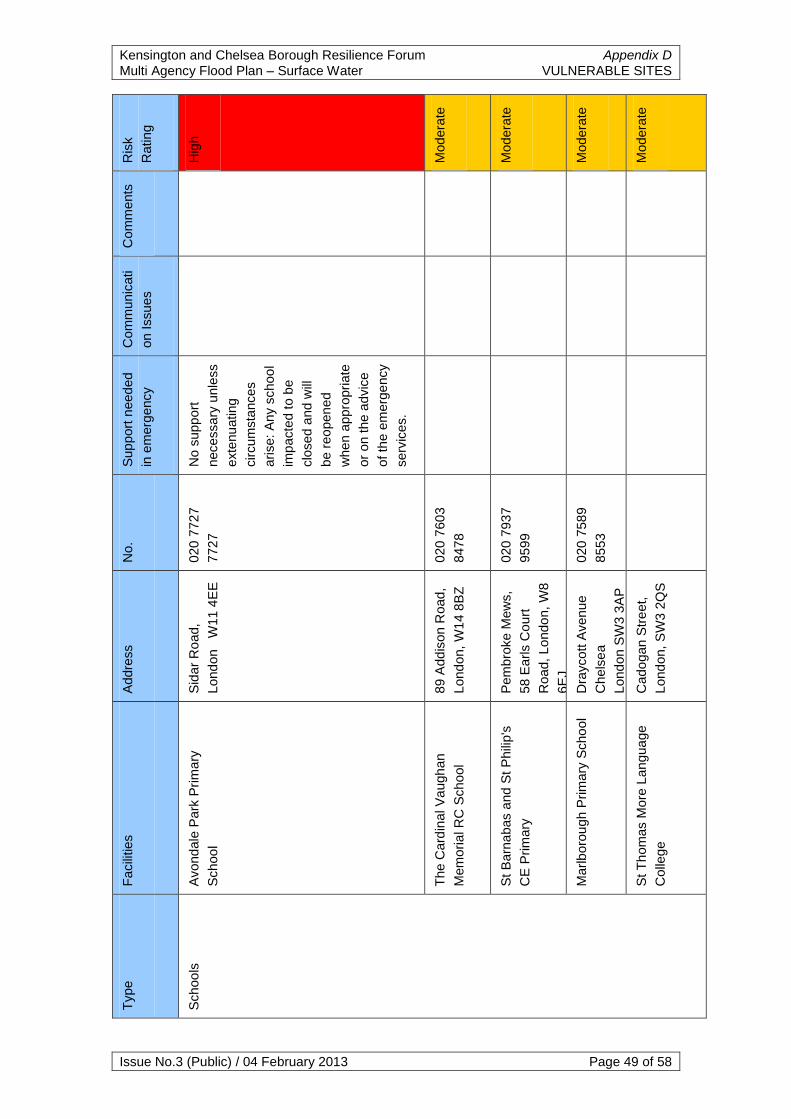
Kensington and Chelsea Borough Resilience Forum Appendix D
Multi Agency Flood Plan – Surface Water VULNERABLE SITES
Issue No.3 (Public) / 04 February 2013 Page 49 of 58
Ris
k
Rating
Hig
h
Modera
te
Modera
te
Modera
te
Modera
te
Com
ments
Com
mun
icati
on Issues
Sup
port
need
ed
in e
merg
ency
No s
upp
ort
necessary
unle
ss
exte
nu
ating
circum
sta
nces
arise:
Any s
choo
l
imp
acte
d t
o b
e
clo
sed a
nd w
ill
be r
eo
pen
ed
when a
ppro
pri
ate
or
on t
he a
dvic
e
of th
e e
merg
ency
serv
ices.
No.
020 7
72
7
7727
020 7
60
3
8478
020 7
93
7
9599
020 7
58
9
8553
Addre
ss
Sid
ar
Ro
ad,
Lond
on
W11 4
EE
89 A
dd
ison R
oad
,
Lond
on,
W1
4 8
BZ
Pem
bro
ke M
ew
s,
58 E
arls C
ourt
Road,
Lo
ndo
n,
W8
6E
J
Dra
ycott A
ven
ue
Chels
ea
Lond
on S
W3 3
AP
Cado
gan S
tre
et,
Lond
on,
SW
3 2
QS
Facili
ties
Avond
ale
Park
Prim
ary
Schoo
l
The C
ard
inal V
augh
an
Mem
oria
l R
C S
cho
ol
St B
arn
abas a
nd S
t P
hili
p's
CE
Prim
ary
Marlb
oro
ugh P
rim
ary
Scho
ol
St T
hom
as M
ore
Lan
gua
ge
Colle
ge
Type
Schoo
ls

Kensington and Chelsea Borough Resilience Forum Appendix D
Multi Agency Flood Plan – Surface Water VULNERABLE SITES
Issue No.3 (Public) / 04 February 2013 Page 50 of 58
Ris
k
Rating
Modera
te
Low
-
Modera
te
Low
-
Modera
te
Low
-
Modera
te
Low
-
Modera
te
Com
ments
Com
mun
icati
on Issues
Sup
port
need
ed
in e
merg
ency
No.
020 7
58
9
2438
020 7
93
7
0740
020 7
35
2
1512
020 8
20
6
6900
020 8
38
3
6123
Addre
ss
Cado
gan S
tre
et
LO
ND
ON
SW
3 2
QT
2 K
ensin
gto
n
Churc
h C
ourt
,
Lond
on,
W8
4S
P
Gro
und/
1st F
loor
30, F
leet
Str
eet
Lond
on
150 B
arl
by R
oa
d
Nort
h K
ensin
gto
n
W10
6B
S
63-6
5 L
ancaste
r
Road
Lond
on W
11 1
QG
Facili
ties
St Josep
h R
C P
rim
ary
Schoo
l
St M
ary
Ab
bots
CE
Prim
ary
Scho
ol
Vio
let
Me
lchett
Fam
ily
Centr
e
Pall
Mall
Centr
e f
or
Menta
l H
ea
lth
Park
sid
e C
linic
Type
Menta
l H
ea
lth S
ites

Kensington and Chelsea Borough Resilience Forum Appendix D
Multi Agency Flood Plan – Surface Water VULNERABLE SITES
Issue No.3 (Public) / 04 February 2013 Page 51 of 58
Ris
k
Rating
Low
-
Modera
te
Low
-
Modera
te
Com
ments
Com
mun
icati
on Issues
This
recom
me
nda
t
ion is a
lready
on o
ur
contin
gency
pla
nnin
g
pro
gra
mm
e
Sup
port
need
ed
in e
merg
ency
As the b
uild
ing is
appro
xim
ate
ly 1
0
feet
above t
he
gro
un
d level th
e
build
ing s
hou
ld
not b
e a
ffecte
d
with f
lood
ing.
How
ever,
to g
et
into
the
bu
ildin
g
could
be a
difficultly
an
d w
e
would
eith
er
need
the
wate
r
pum
ped a
way o
r
we w
ould
use
anoth
er
child
ren‟s
ce
ntr
e
or
the H
arr
ow
Clu
b in
an
extr
em
e
em
erg
ency.
The C
hild
ren
‟s
hom
e h
as its
ow
n e
merg
ency
pla
ns in p
lace
that cover
floo
din
g
scenarios a
nd
will
be a
ctiva
ted
if a
n incid
ent
arises.
No.
020
8969
932
7
0207
22
1
4298
Addre
ss
154 F
resto
n R
d
Lond
on,
W1
0 6
TR
3 S
t M
ark
s C
lose
,
Kensin
gto
n A
nd
Chels
ea, L
ond
on
W11
1T
Z
Facili
ties
Laty
mer
Child
ren C
entr
e
St M
ark
s C
hild
ren
‟s
Hom
e
Type
Socia
l C
are
Sites

Kensington and Chelsea Borough Resilience Forum Appendix D
Multi Agency Flood Plan – Surface Water VULNERABLE SITES
Issue No.3 (Public) / 04 February 2013 Page 52 of 58
Ris
k
Rating
Low
-
Modera
te
Low
-
Modera
te
Low
-
Modera
te
Com
ments
Com
mun
icati
on Issues
Sup
port
need
ed
in e
merg
ency
The R
oya
l
Boro
ugh o
f
Kensin
gto
n a
nd
Chels
ea s
ites
have th
eir o
wn
em
erg
ency a
nd
busin
ess
contin
uity p
lans
inclu
din
g
evacuating a
nd
relo
cation
wh
ich
should
suff
ice in
a flo
od
ing
scenario w
ith
out
the a
id o
f
add
itio
na
l
em
erg
ency
serv
ices u
nle
ss
exte
nu
ating
circum
sta
nces
arise.
No.
020 7
59
8
4401
020 7
59
8
4640
020 7
36
1
2220
Addre
ss
140 L
ad
bro
ke
Gro
ve
LO
ND
ON
W10
5N
D
Gro
und F
loor.
36
B
Oxfo
rd G
ard
en,
Lond
on,
W1
0 5
UQ
The T
ow
n H
all,
Horn
ton
Str
eet,
Lond
on W
8 7
NX
Facili
ties
Westw
ay I
nfo
rmation
Centr
e
Child
rens R
esourc
e
Team
Kensin
gto
n T
ow
n H
all
Type
Council
Off
ices

Kensington and Chelsea Borough Resilience Forum Appendix D
Multi Agency Flood Plan – Surface Water VULNERABLE SITES
Issue No.3 (Public) / 04 February 2013 Page 53 of 58
Ris
k
Rating
Low
-
Modera
te
Modera
te
Modera
te
Com
ments
Com
mun
icati
on Issues
Sup
port
need
ed
in e
merg
ency
No.
020 7
59
8
4640
020 7
59
8
4964
020 7
85
4
5960
Addre
ss
Gro
und F
loor.
36
B
Oxfo
rd G
ard
en,
Lond
on,
W1
0 5
UQ
282 E
arls C
ourt
Road,
Lo
ndo
n,
SW
5 9
AS
2 B
EA
TR
ICE
PL
AC
E,
LO
ND
ON
,
W8 5
LP
Facili
ties
Child
rens D
isab
ility
Tea
m
Earls C
ourt
Centr
al S
ocia
l
Work
Offic
e
Kensin
gto
n R
ecru
itm
ent
Type

Kensington and Chelsea Borough Resilience Forum Appendix E
Multi Agency Flood Plan – Surface Water ROADS AT RISK
Issue No.3 (Public) / 04 February 2013 Page 54 of 58
APPENDIX E – ROADS AT RISK FROM SURFACE WATER
FLOODING
Streets at High Risk from Surface Water in The Royal Borough of
Kensington and Chelsea:
Addison Gardens North of Palace Garden Terrace
Aklam Road North West Corner of Sloane Square
Colling Place Numerous spots along Chelsea Embankment
Cromwell Road Old Church Street
Cromwell Road Pembroke Road
Donne Place Recliffe Street
Elm Park Gardens Redcliffe Gardens
Elystan Place Sirdar Road
Gloucester Road Smith Terrace
Kings Road Stonleigh Place
Latimer Road Tedworth Street
Mallard Street Walton Street

Kensington and Chelsea Surface Water Flooding Appendix F Multi Agency Flood Plan – Surface Water LFB CALL LOG
Issue No.3 (Public) / 04 February 2013 Page 55 of 58
APPENDIX F – LONDON FIRE BRIGADE CALL LOG 20TH JULY
2007
Roads in The Royal Borough of Kensington and Chelsea which the Fire
Brigade attended more than once due to flooding on 20th July 2007:
() = the number of incidents in the road that the fire brigade actually attended
Bramley Road (2) Ladbroke Grove (7)
Chamberlayne Road (3) Longridge Road (2)
Church Road (3) Moscow Road (2)
Colville Square (3) Portobello Road (3)
Earls Court Road (2) Queensdale Road (2)
Elgin Crescent (3) Saint Anns Villas (3)
Furness Road (2) Saint Marks Place (2)
Garnet Road (2) Warwick Road (2)
Harrow Road (3) Westbourne Grove (10)
Kensington High Street (5)

Royal Borough of Kensington and Chelsea Appendix G Multi Agency Flood Plan PUBLIC ADVICE AND GUIDANCE
Issue No.3 (Public) / 04 February 2013 Page 56 of 58
APPENDIX G – PUBLIC ADVICE AND GUIDANCE
The Royal Borough of Kensington and Chelsea recommend that the public
make use of the Environment Agency and the Health Protection Agency‟s
advice.
Environment Agency:
The Environment Agency has various leaflets of advice:
Preparing for a Flood
During a Flood
After a Flood
These leaflets can be found on the Environment Agencies website, in PDF
format and in an audio version.
The Environment Agency also provides information on flooding for businesses
http://www.environment-agency.gov.uk/business/topics/flooding/default.aspx
Health Protection Agency (HPA):
The HPA has a list of Frequently Asked Questions available on its website.
These can be found at:
http://www.hpa.org.uk/webw/HPAweb&HPAwebPrinterFriendly/HPAweb_C/12
13686561005?p=1213686561915
Met Office:
The Met Office administer severe weather warnings via email alerts which can
be signed up to through their website
http://www.metoffice.gov.uk/weather/uk/uk_forecast_warnings.html

Kensington and Chelsea Borough Resilience Forum Appendix H Multi Agency Flood Plan – Surface Water SANDBAG POLICY
Issue No.3 (Public) / 04 February 2013 Page 57 of 58
APPENDIX H – SANDBAG POLICY
In keeping with the strategic aim of preventing large scale flooding to the
borough, key installations and public infrastructure priority will initially be given
to:
Temporary works as identified by responding agencies to prevent
flooding to large areas of the city affecting both residential and
commercial properties.
Repairs to existing flood defences
Key installations: Utility stations, hospitals, schools, communication
centres, council buildings (i.e. residential homes) and operational
emergency services premises.
Critical transportation routes and other essential roads.
Situations covered by this Policy
This policy is intended to counter the threat from overtopping of the River
Thames, breaches of permanent or temporary defences, or areas of surface
water flooding.
Public Supplies
The Royal Borough of Kensington and Chelsea will not provide sandbags to
the public if a Surface Water Flooding incident occurs.
Building a Sandbag Wall:
It is essential to fill the sandbags correctly, they must not be over-filled.
Sandbag walls should never be constructed with a vertical face, but should be
laid in a pyramid shape with never less than two rows at the top of the
pyramid.

Kensington and Chelsea Borough Resilience Forum Appendix H Multi Agency Flood Plan – Surface Water SANDBAG POLICY
Issue No.3 (Public) / 04 February 2013 Page 58 of 58
Figure L1 - Sandbag wall cross-section showing pyramid formation
Figure L2 – Location of plastic waterproofing sheeting
Sandbag walls are not waterproof, but waterproofing can be achieved using
plastic sheeting which is threaded through the layers. Avoid placing any of the
outside wall in the direction of the water.