Embed Size (px)
Citation preview

78 BIODIVERSITY REPORT | KING COUNTY | 2008
2. GOvERNANCE
In this section, important aspects of biodiversity management or governance in King County are dis-cussed, followed by descriptions of on-going biodi-versity-related program and projects.
2.1 bIODIvERSITY IN COUNTY mANAGEmENT
The King County Comprehensive Plan (KCCP)1 is the primary policy document for all elements of King County government. The goals and policies described in the plan are intended to guide the development of land use, transportation, housing, economic develop-ment, environmental regulations, and programs such as land acquisition and stream restoration, among many others. The KCCP is the result of numerous discussions among King County citizens, the King County Execu-tive Office, and the King County Council. The KCCP, once adopted by the County Council, becomes the one common statement of County policies to which all departments of the County refer.
Biodiversity is a major environmental theme for the most recent version of the KCCP and is embodied in two distinct sections of the plan:
From the Fish and Wildlife section:
It is King County’s goal to conserve fish and wildlife resources in the county and to main-tain countywide biodiversity. This goal may be achieved through implementation of several broad policy directions that form an integrated vision for the future. Each of the pieces is neces-sary for the whole to be successful. The policy objectives are to 1) identify and protect critical fish and wildlife habitat conservation areas, 2) link those critical habitat areas and other pro-tected lands through a network system, and 3) integrate fish and wildlife habitat and conserva-tion goals into new and existing developments. Conservation of biodiversity is necessary if wild-life benefits currently enjoyed by residents of the county are to be enjoyed by future generations.”
n
In the Wetlands section:
Protecting native species biodiversity depends upon maintaining biological linkages, supporting the natural processes (like hydrology) that shape wetland habitat, and preventing fragmentation of wetland habitats. Small wetlands strategically located between other wetlands may provide important biological links between other, higher quality wetlands. Wetlands adjacent to habitat networks also are especially critical to wildlife functions and should receive special consider-ation in planning land use.
From the KCCP, these goals and policies are translated into regulations via the Critical Areas Ordinance:
The purpose of this chapter is to implement the goals and policies of the Growth Management Act, chapter 36.70A RCW, Washington ((S))state Environmental Policy Act, ((RCW)) chapter 43.21C RCW, and the King County Comprehen-sive Plan, which call for protection of the natural environment and the public health and safety by Protecting unique, fragile and valuable elements of the environment including, but not limited to, fish and wildlife and ((its)) their habitats, and maintaining and promoting countywide native biodiversity.
These policies, goals, and regulations are the common basis upon which the integration of biodiversity rests in the County. In practice, most of the responsibility for carrying out the biodiversity goals lies mainly in two departments of the County: the Department of Natural Resources and Parks (DNRP, where the main natural resource programs of the County are housed), and the Department of Development and Environmental Ser-vices (DDES, responsible for applying and enforcing County ordinances of many kinds, not just biodiver-sity). A third department, Transportation, also employs fishery biologists and wetland ecologists, whose task is developing suitable mitigations for transportation projects. Other County departments remain beholden to the goals and policies of the KCCP and are required to adhere to the CAO during the implementation of their particular goals and objectives. Not surprisingly, the
n
1 King County will update the KCCP in 2008; changes will include the addition of an entire section devoted to biodiversity.
080310_KCBioDiv_RPT.indd 78 4/1/08 3:46:31 PM

BIODIVERSITY REPORT | KING COUNTY | 2008 79
distinct goals of the separate departments often clash over issues related to biodiversity.
Up to this time, much of the work of biodiversity pro-tection has been housed in and initiated by the DNRP, where the main body of that work has been directed at ecological lands acquisition and management, wetland and stream protection, and salmon recovery. However, protection has not been expressly directed at the mul-tiple scales of biodiversity. In the 1990s, King County DNRP had a Wildlife Program that provided advice to citizens and the Executive staff, and developed a wildlife habitat network that is part of the KCCP. The Wildlife Program was terminated because of budget cuts. The responsibility for advising on wildlife issues is mainly informal and resides in current staff. Mainly, programs for biodiversity protection tend to be carried on the backs of other, more specific programs such as salmon recovery, or are focussed on various habitats such as streams and wetlands. When species-specific diversity is addressed, it has been for a select number of species, usually specified by the KCCP or in the Growth Man-agement Plan of the State of Washington. These species have not been chosen for their status as indicators or sentinels of biodiversity, however, and their protection relies mainly on the protection of occupied habitats or on certain elements of that habitat, such as the presence of a nest. Other aspects of biodiversity at larger scales (landscapes and ecosystems) or smaller scales (genetic or life history types) have not been addressed either by programs of objectives.
In recent years, because of the intense legal focus on salmon, streams, and wetlands, King County has been particularly successful in addressing biodiversity at the habitat scale, at least for aquatic habitats. Since 1981, the County has had regulations that control land use and development near wetlands. As a result, filling and manipulation of these habitats declined dramatically, almost immediately, and has not returned to pre-ordi-nance levels in the County’s jurisdiction. However, annexations have led to the transfer of land from unin-corporated King County to city jurisdictions, especially in the suburban areas to the east, in the uplands. In most cases, the regulatory protections have then been relaxed and wetland protections diminished. In 1990,
King County expanded protection to streams as well, requiring 15 - 30 meter (50 - 100 feet) buffers along most watercourses. Recently, that protection was increased to about 50.3 meters (165 feet) for streams to a maximum of 91.4 meters (300 feet) around wetlands. New regula-tions, though greater in scale and with higher probabili-ties of success, are applied to an ever-diminishing area of County jurisdiction. With the pace of population and economic growth and the impetus of the Growth Man-agement Act, annexations of the growing areas of the county are encouraged. The hard-won protections are often lost in that process. In effect, the most successful program for biodiversity protection in the county has also become the most challenging.
Least successful aspects of biodiversity management are those that are required for large-scale biodiversity and species-based biodiversity—these aspects are closely related. The protection of functional landscapes and ecosystems at a scale necessary for sustaining popula-tions requires land use management across many 10s of square miles and across multiple environmental gradients. Because much of the county’s landscape was altered many years before the harmful environmental effects were considered important, the opportunity for protection at that scale is rare, especially in the low-lands. This loss of opportunities may not be the case, however, in the foothills and subalpine areas, but a concerted effort is necessary to identify these landscape and ecosystems and set about protecting them. This effort would also require some recovery of lands in order to retrieve some ecological function appropriate to sustaining native species. At the species level, regula-tory successes are equally difficult to find. Much of the problem seems to lie in the inconsistency of the legal framework with the sciences of conservation biology, population dynamics, and landscape ecology. Most spe-cies are not confined to small portions of the landscape but must be somewhat free to move about for feeding, breeding, rearing young, and interacting with other members of their species to insure adequate genetic exchange and population sustainability. In landscapes fragmented by development, even the most enlightened habitat-based protections are likely to fail if the distribu-tions, spatial structure, and diversity of populations are not taken into account.
080310_KCBioDiv_RPT.indd 79 4/1/08 3:46:31 PM

80 BIODIVERSITY REPORT | KING COUNTY | 2008
2.2 bIODIvERSITY PROjECTS
Each of the following five programs related to King County’s biodiversity are described in detail below:1. Puget Sound Salmon Recovery Plan2. Natural Resource Lands Program3. Greenprint Program4. Regulatory Programs
a. Critical Areas Ordinance b. Shorelines Master Program
5. Economic valuation of biodiversity in King Coun-ty
Shared Strategy for Puget Sound: Puget Sound Salmon Recovery PlanThe Puget Sound Salmon Recovery Plan’s goals are to recover self-sustaining, harvestable salmon runs in a manner that contributes to the overall health of Puget Sound and it’s watersheds and allows us to enjoy and use this precious resource in concert with our region’s economic vitality and prosperity. More specifically, the goals are to:
1. Prevent the further loss of Chinook and chum salmon populations in the Puget Sound and Hood Canal;
2. Recover salmon populations sufficiently to allow their removal from the Endangered Species list;
3. Recover salmon populations sufficiently to per-mit Tribal, recreational, and commercial harvests to resume.
Salmon recovery is mainly a large-scale stewardship project. In the words of the Plan:
“The Shared Strategy for Puget Sound is a collab-orative initiative built on the foundation of local efforts, supported by leaders from all levels of government and sectors of our communities, and guided by the Puget Sound Technical Recovery Team’s regional recovery criteria.”
The Plan’s timeframe and start/end dates are thus:
The current Plan outlines an initial 10-year effort in what is generally thought to be a 30 to 50 year undertaking. Planning work began in 2001. The Plan was completed in 2006 and formally accepted by the National Marine Fisheries Service in February of 2007. The current plan is intended to act as
n
n
a foundation until 2017 although modifications will be made to the plan continuously through adaptive management.
The Plan is decidedly a combination of ecological and a people-oriented approach. Regional recovery criteria for salmon were developed by a group of seven con-servation scientists, with specific areas of expertise, representing federal, state, tribal, and local agencies (the Puget Sound Technical Recovery Team, or PSTRT). These criteria, and the scientific framework in which they are embedded, are used by 15 local watersheds to develop strategies and actions to recover their respec-tive salmon populations. The recovery planning process has generally followed this sequence:
1. At the outset, the PSTRT, using an ecological and meta-population approach to salmon conserva-tion, defined the specific independent popula-tions within the larger group of populations (the meta-population aka the Evolutionarily Sig-nificant Unit) of both Chinook salmon and chum salmon in Puget Sound and Hood Canal;
2. Using first principles of conservation ecology, together with population dynamic modelling approaches, the PSTRT defined recovery criteria for the ESU based on four basic attributes of populations: abundance, productivity, diversity, and spatial structure. The PSTRT also established more specific abundance goals for each popula-tion within the ESU. These goals are used by individual watersheds to set near-term and final recovery objectives;
3. The Shared Strategy (the name given to the col-laboration among Federal, Tribal, state, and local governments), meanwhile, worked with various sectors of the Puget Sound community—forestry, agriculture, business groups, fishermen, environ-mental groups, and unaligned citizens, to craft a common purpose and approach for the recovery work to follow. The collaboration, largely vol-untary, is based on the continuing commitment of the many groups to preserving salmon in Northwest waters. It is built on the work already underway in most watersheds, seeking to foster further work through capacity-building, sharing of resources, and common funding goals;
080310_KCBioDiv_RPT.indd 80 4/1/08 3:46:32 PM

BIODIVERSITY REPORT | KING COUNTY | 2008 8�
4. A Puget Sound Salmon Recovery Plan, consist-ing of 15 “chapters” (one for each participating watershed) was developed by the collaboration and submitted to the National Marine Fisheries Service to satisfy the requirements imposed by the Endangered Species Act.
Because the scope of the planning and recovery effort extends to the entire Puget Sound basin, an area cover-ing 10,000 square miles, 14 watersheds, and 22 inde-pendent salmon populations, a new organization was created especially for this recovery work: the Shared Strategy for Puget Sound. This rather small group, which includes an executive director and a handful of staff members, is responsible for coordinating the devel-opment of the several parts of the recovery plan (each watershed has a “chapter” in the final recovery plan), transferring the scientific information from the PSTRT to the watersheds, and maintaining the cohesiveness of the collaborators. Finally, the Shared Strategy assembled the Plan in June of 2006 for transmittal to the respon-sible federal agency, the National Marine Fisheries Ser-vice, who accepted the Plan in early 2007.
Shared Strategy is directed by a steering committee that represents federal, tribal, state and local jurisdictions from each watershed within Puget Sound. In all, over 200 jurisdictions are represented in the collaboration, including 2 federal agencies, several state agencies, some 12 Puget Sound Tribal governments, 12 counties, and dozens of cities.
King County, mainly in the person of the County Execu-tive and his staff, played a critical role in supporting the formation of the Shared Strategy and the process for plan development. In addition, several staff members from King County’s Department of Natural Resources and Parks are directly involved in the development and implementation of salmon recovery chapters for 3 watersheds that lie wholly or partly within the county: The Green River Watershed, the Cedar River Watershed, and the Snohomish Watershed. These staff members include biologists, planners, project managers, and coordinators; they share duties with other staff funded through inter-local agreements among the many other cities within each watershed. For some staff members, particularly the biologists, the salmon recovery plan
work occupies only a portion of their work, gener-ally less than one quarter. These staff members are also responsible for policy/regulatory development and review, development and review for other County non-salmon programs and projects, monitoring, and general environmental review.
Staff scientists participate as technical coordinators, technicians, and advisors for each of three recovery areas within the county. Since this work began in 2002, the budget for the Science Section within the Depart-ment of Natural Resources and Parks has been over US$9.8 million (Table 6).
Table 6. Budget for Science Staff Working on the Shared Strategy.
YearStaff (Full or Part Time) budget* USD
2002 12 3,163,9362003 12 2,301,3972004 12 1,988,0742005 11 1,387,3652006 7 970,882
TOTAL 9,811,653*Includes staff cost, materials, production, consultant costs, etc.
The Regional Services Section has also participated in this program and provides watershed coordinators, analysts, and planners to the effort. Their budget and staff time is shown in Table 7.
Table 7. Budget for Regional Services Staff Working on the Shared Strategy
YearStaff (Full or
Part time) budget USD2001 4,794,080** 2002 8 921,7992003 8 917,8612004 8 912,4332005 7 790,2002006 8 906,574
TOTAL 9,242,947**Science and Regional Services costs are combined for this year.
080310_KCBioDiv_RPT.indd 81 4/1/08 3:46:32 PM

82 BIODIVERSITY REPORT | KING COUNTY | 2008
Ecological LandsKing County’s Ecological Lands are a collection of 81 sites covering 5,300 acres that are managed as Natural Areas. This is not a project, per se, but a set of lands and the way in which they are managed.
EcologicalLandsVision: Contribute to the conservation of native biodiversity
Goals for management:
Maintain and restore ecological processes, struc-tures, and functions.Provide protection for rare and endemic species, habitats, and ecosystems.Allow for low-impact passive recreational and interpretive opportunities that do not conflict with other goals.
The responsibility for the conservation of ecological value of these lands falls solely on the County. The County began acquiring these lands in approximately 1975, and acquisitions continue to be on-going, as is pro-tection, restoration work, and maintenance. Biological inventory and ecological assessment of the lands began in the spring of 2004. To date, 10 of these Natural Areas have been analyzed under the current protocols. Man-agement plans have been written for approximately 45 sites and cover about 75 percent of the acreage.
Acquisitions are currently chosen typically based upon previous landscape-level guidance documents. Cur-rently, ecologists within the Water and Lands Resources Division inventory, assess, and analyze these lands. The ecologist looks for rare habitats or ecosystems in addition to rare plant communities or animal species. A report is prepared that describes properly function-ing and ill-functioning processes as well as the current trajectory of the site in terms of both natural processes and vegetation communities. After a draft report is complete, all stakeholders convene for a given Natural Area and discuss the findings and collaborate on deci-sions for management actions. It is hoped that in some instances, research questions will be tested through monitoring programs, but to date none have been estab-lished. This ecological information and analyses are used by the Natural Resource Lands planners in writing the individual “Site Management Guidelines.”
n
n
n
The County’s commitment to open space and resource lands has been driven by a series of bond issues passed by citizens in the 1970s (Forward Thrust) and again, by local initiative, in the 1980s and mid 1990s. This began with the Agricultural Lands bonds in mid-1970s but expanded to a larger resource land initiative in the 1980s. These were mainly conservation futures bonds intended to purchase lands that had (extractable) resource value and ecological value. These were largely driven by citizen leaders early on. During the last decade or so, the initiative has come from the County Executive and members of the Council, driven by a long-standing citizen open space committee. This culminated in the Waterways 2000 initiative in the late 1990s that gave rise to the ecological land program we have today. The County has been a leader in this type of land acquisi-tion for many years. Field visits are conducted by one or more ecologist, and biological features and ecologi-cal processes of the site are inventoried. Information gathered then informs management actions, including restoration work. Restoration work is carried out by varying groups, including through the Volunteer Pro-gram (described in Section 4.2). Resource protection and maintenance is carried out by Parks Division Staff.
Natural Resource Lands Program Annual Cost for Eco-logical Lands is US$ 250,000 for 2.25 FTEs (Full-time Equivalent, which is equal to equal to one full time staff member for one year); Preserve and Protect Ecological Lands/Maintain Restoration Projects are budgeted US$ 550,000 per year, for approximately 3 FTE per year; 2 ecologists are budgeted from the science staff for a total of 0.3 FTE, or the equivalent of approximately US$ 32,000 annually.
Greenprint ProgramThe Greenprint Program was developed to assist with open space and working resource land planning. The Greenprint Program is responsible for developing a countywide conservation strategy to protect open space resources for such purposes as salmon recovery, farm and forest preservation, flood hazard reduction, and parks and regional trails. In addition to a countywide strategy, the Greenprint methods have been applied to other more specific areas in the county, such as Vashon Maury Island. These smaller-scale analyses allow for a
080310_KCBioDiv_RPT.indd 82 4/1/08 3:46:33 PM

BIODIVERSITY REPORT | KING COUNTY | 2008 83
customized conservation strategy that better addresses the landscape features and community values.
The Greenprint is a technical analysis that incorporates both ecological information and community values to develop an open space and resource lands conservation and acquisition strategy. This program was initiated in 2003 and has been an on-going program since. The Greenprint for King County took approximately 22 months to complete. The Greenprint for Vashon Maury Island was kicked off in April 2005 and the report is expected to be completed in April 2007.
When applying the Greenprint methods to a more localized area, both an ecological and people-orientated approach is used. Community involvement is neces-sary in defining the vision and goals for the area. These community and environmental goals help guide how to model various geo-spatial environmental parameters to produce a map representing high value lands for ecological conservation. The model output combined with expert knowledge from scientists and commu-nity groups is used to identify conservation focus areas. Implementation of the conservation strategy is carried out in coordination by both the County and non-profits that are focus on land conservation.
Open Space and regional trails planning and acquisi-tion is one of the Executive initiatives for King County. The Greenprint for King County is considered part of this initiative. In 2003, King County partnered with the Trust for Public to develop The Greenprint for King County. With the completion of the model and reports, the Greenprint Program was created to assist with implementation and to respond to Executive and management requests and special projects. Staff for the Greenprint Program includes a project lead that is dedicated half-time to this work. To date, most of pro-gram lead’s time has been spent on the Greenprint for Vashon Maury Island. Other staff that have supported the Vashon Maury Island work include scientists, GIS analysts, graphic artists, and a basin steward. When not working on the Greenprint Program, the program lead is also implementing the Mitigation Reserve Program, a program that addresses off-site mitigation.
The cost of the Trust Public Land contract to develop the Greenprint for King County was US$ 100,000. This contract included the analysis of existing conservation efforts in the county, production of two reports, and development of a GIS model. Additional costs include County staff time of approximately another US$ 60,000, which included the cost of a project manager and a GIS analyst. The ongoing annual program cost is approxi-mately US$ 60,000, which covers approximately 50 percent of the program lead time and as-needed GIS analyst support.
Regulatory Programs: Shorelines master ProgramThe goals of the Shorelines Master Program are to: (1) update the body of policies and regulations adopted in 1978 that were designed to protect and restore existing ecological functions along shorelines of the state, (2) protect archaeological and historic sites of significance, (3) promote water dependent uses along the shorelines, and (4) address gaps in public access to waters of the state.
The Shorelines Master Program is a State-mandated update of the policies and regulations governing land use along shorelines of the state, involving analyses of current conditions, projections of cumulative impact, and restoration planning. The program must meet state guidelines in order to be adopted.
Work on the program began in July 2005, with proposal for adoption by County Council scheduled for late in 2008. The shorelines characterization uses an ecological approach. Additionally, peer review and public com-ment on the products have been solicited to date.
Staff in both the Department of Natural Resources and Parks and department of Development and Environ-mental Services have been involved in the project. Gen-eral roles of staff on the projects have included program managers, GIS specialists, communication specialists, graphic designers, ecologists, environmental scientists, and water quality planners. Daily roles have been approximately equivalent. Both senior and junior staff have been involved in the work.
080310_KCBioDiv_RPT.indd 83 4/1/08 3:46:33 PM

84 BIODIVERSITY REPORT | KING COUNTY | 2008
Currently, 16 people have some responsibilities within the project; all have other work responsibilities in addi-tion to the work on the program update. A grant from the Washington Department of Ecology covers much of the labor expense. Total annual budget is US$ 250,000.
Regulatory Programs: Critical Areas Ordinance Development and Implementation The goal of the Critical Areas Ordinance (CAO) is to protect the existing functions and values of critical areas and ensure public safety where there are identi-fied hazard areas. The ordinance applies throughout unincorporated King County. Updates to the ordinance are mandated by the State of Washington’s Growth Management Act.
The ordinance identifies two general classes of critical areas: (1) environmentally sensitive critical areas, which include rivers, streams, lakes, wetlands, and wildlife habitat; and (2) public safety critical areas (hazard areas), which include areas at high risk for erosion, landslides, earthquakes, or flooding, as well as coal mine hazard areas. The King County Code protects criti-cal areas as well as their buffers in order to protect public health and safety and to promote environmental health in the region. Buffers, generally speaking, are areas adjacent to a critical area that are also restricted from specific build-ing and development activities.
Standards and regulations governing development practices in and adjacent to critical areas were adopted by the King County Council in 2004. This adoption followed an evaluation of the underlying scientific information that forms the basis for the environmental protections in the ordinance and a lengthy public pro-cess that included an advisory panel of stakeholders, several public meetings, and testimony by citizens and staff before the King County Council. The Council made several adjustments to the ordinance including the directive to develop a stewardship program for rural landowners that would allow some deviation from the regulations and standards where necessary. That program, known as the Rural Stewardship Program, is described in Section 4.2.
Implementation of the CAO standards and practices begins when a development permit is received by the County’s Department of Development and Environ-mental Services (DDES). After review by DDES’s tech-nical and planning staff, the proposal may be modified by a series of permit conditions that are attached to the project and attempt to mitigate the effects of the devel-opment proposal on any critical areas that occur within the development site. Implementation continues with regular inspections and the development and imple-mentation of a monitoring and evaluation plan.
The Department of Development and Environmental Services and the Department of Natural Resources and Parks cooperate in the implementation and evaluation of the Critical Areas Ordinance.
Economic valuations of biodiversity in King CountyAlthough certain elements of King County’s biodiver-sity have been assigned economic value for many years (fisheries and timber are two obvious examples), the valuation of the sum of biodiversity elements required the development of tools and methods beyond the reach of traditional economics. In the last decade or two, development of the field of ecological economics has produced some of these methods. In the Salmon Habitat Plan for the Green-Duwamish River (August 2005), which was prepared as a chapter in the Puget Sound Salmon Recovery Plan, a valuation was devel-oped using the methods of ecological economics. This attempt was the first such valuation by King County.
The study, Ecosystem Services Enhanced by Salmon Habitat Conservation in the Green/Duwamish and Central Puget Sound Watershed, has two parts: an over-view of the ecological services and benefits (including biodiversity) within the watershed and an analysis of the enhancement of these services and benefits through restoration and rehabilitation activities undertaken for Chinook salmon. A very brief summary of the work is presented here. The ecosystem services and goods evaluated in the study are:
Flood protectionNatural stormwater controlDrinking water production and filtration
n
n
n
080310_KCBioDiv_RPT.indd 84 4/1/08 3:46:33 PM

BIODIVERSITY REPORT | KING COUNTY | 2008 85
Reduction of pathogens and pollutantsWaste absorptionStorm protectionBiodiversity and biodiversity preservationNutrient regulationNatural resource commodity production (fish, shellfish, timber)Nursery and refugia servicesAesthetic valueRecreational opportunities
In reviewing the ecological services present in the Green-Duwamish watershed, it is important to consider two factors that influence the ability of the watershed to provide ecological services: the amount of undeveloped land in the watershed (the remaining ecosystems or parts of ecosystems), and the quality, health, or condi-tion of that land. Developed and partially developed land can still produce ecosystem services if critical ele-ments of ecosystems and functions are preserved, but insensitive development is likely to require the costly replacement of lost ecosystem services. In this study, land cover classifications were used to represent ecosys-tems, and health indicators were derived from remotely sensed data and expert opinion. This land cover method (derived from the methods of Boumans et al. 2004) and the use of expert opinion has been used elsewhere to establish a gage of ecosystem health and develop a range of values for various ecosystem services. Both low and high estimates derived from the range of ecosystem values found in the literature are given in Table 6. In general, wetlands, forests, coastal and estuarine areas are the most prolific generators of ecological services
n
n
n
n
n
n
n
n
n
and value. Table 5 was derived from landcover esti-mates based on Landsat data from 1995 and 2001.
Table 8. Estimates of the value of landcover types.
Ecosystem Category Low value in US$ high value in US$Forest 1,295,830,000 4,775,863,000 Grasslands and shrublands 322,366,000 1,237,833,000Agriculture and pasture 6,406,000 23,136,000Urban 7,209,000 38,084,000Lakes, Rivers, Ponds 4,200,000 26,156,000Wetlands 25,367,000 89,705,000Coastal 5,473,000 29,444,000Rock 24,599,000 84,281,000TOTAL 1,691,450,000 6,304,502,000
The study revealed that ecosystems of the Green-Duwamish produce between US$ 1.7 billion to 6.3 bil-lion each year for individuals, businesses, and govern-ments within the watershed. Because not all services were valued, this is an underestimate.
Continuous and Future valueThe continuous flow of ecosystem benefits and ser-vices was examined by estimating the net present value (NPV) of a good or service which is the measure in cur-rent dollars of this year’s benefits plus an estimate of the future discounted benefits (a reduction in perceived future value). Using a discount rate of 3.5 percent to estimate NPV, the summed value of ecosystem goods and services in the watershed is US$ 48 billion to 180 billion. Once restored, the ecosystems of the watershed should produce greater value for its inhabitants. If this restored value is calculated over 100 years and assumes that ecosystems, once healthy, are self-maintaining and that the citizen of the future will value these services equally, then a zero discount rate can be assumed and the 100 year value jumps to between US$ 171 billion and 637 billion. Ideally, far more than 100 years of ben-efits will accrue from healthy ecosystems.
Difficulties in valuationsThe full value of ecological goods and services is inherently difficult to estimate. Ecological services are difficult to value in economic terms unless some com-
080310_KCBioDiv_RPT.indd 85 4/1/08 3:46:34 PM

86 BIODIVERSITY REPORT | KING COUNTY | 2008
parable artificial service can be found (e.g., water filtra-tion) or citizens can be polled to establish a “willingness to pay” value. Even so, the value of an ecological service such as an aesthetically pleasing view has a tremendous range of values among citizens. Furthermore, many eco-logical services may not yet be identified. In the case of this study, the valuations were not intended to capture all value but rather to create “markers” against which future gains and losses could be compared.
080310_KCBioDiv_RPT.indd 86 4/1/08 3:46:34 PM
BIODIVERSITY REPORT | KING COUNTY | 2008 87
3. INTEGRATION
This section includes a description of how biodiversity is represented and integrated into the governance of King County. Additionally, King County’s interaction with outside agencies and other partners in imple-mentation of biodiversity planning and management is discussed.
3.1. mAINSTREAmING bIODIvERSITY mANAGE-mENT INTO COUNTY GOvERNANCE
The integration of biodiversity into management goals and objectives tends to occur most conspicuously dur-ing updates to the King County Comprehensive Plan (KCCP) and to environmental ordinances and regula-tions. At this time, representatives from the several County departments collaborate to develop policies, rules, and methods for assessing and managing the environment. Although these updates are not infre-quent, it is rare that such a discussion occurs outside these updates except through a permit process or specific project that requires some participation across departments. In many, if not most, cases, the staff who work with biodiversity disperse to their respective departments after the work of plan and regulatory update is completed. Even though each department has some staff to advocate for biodiversity, the distinct, practical goals of each department and the dispersal of biological staff among departments tends to dilute the importance of biodiversity in management decisions. In effect, there is no comprehensive, integrated program for, and no staff members directly assigned to, the objec-tives of assessing, describing, and protecting all levels of the county’s biodiversity. Rather, that responsibility has been dispersed among County departments, each with a self-described role in some aspect of biodiver-sity management. At its best, staff members from the County’s regulatory department (Department of Devel-opment and Environment Services, DDES) and the Department of Natural Resources and Parks (DNRP) have a workable relationship for specific projects that come to the attention of DDES. In fact, DNRP staff has worked on project review, monitoring, and evaluation for several projects for which DDES is responsible. In general, however, each department relies on its own staff to provide information and advice to its managers for biodiversity.
In some cases, biological and ecological information, evaluation, and advice may be provided by outside consultants rather than internal department staff; in this case, there may be department staff assigned to review the work and provide guidance for the consultants. This relationship is far from satisfactory where biodiversity is concerned because County policies and objectives may not be considered in all their dimensions. More-over, departmental capacity to manage biodiversity is generally not increased by the use of outside scientists.
In King County, probably all departments consider some aspect of biodiversity in their decision-making. Cer-tainly, the departments of Natural Resources and Parks, Development and Environmental Services, and Trans-portation all must consider habitats and species listed in the Comprehensive Plan and Critical Areas Ordi-nance in their decisions. In particular, for Development and Environmental Services, it is one of their primary responsibilities. The Department of Executive Services, home to the County Executive, has taken biodiversity very much to heart in recent decisions. The Shared Strat-egy for Puget Sound, the newly formed Puget Sound Partnership, and the recent Climate Change Initiative all have biodiversity as a major component and goal. That is not to say that all departments use or under-stand a common definition of biodiversity. In some cases, departmental responsibilities are focused only on certain aspects or elements of biodiversity to the exclu-sion of other elements. In addition, the consideration of biodiversity often begins with a particular project or activity that may affect some aspect of biodiversity. By the time the discussion of biodiversity has reached the project level, the necessary context for the conservation of biodiversity has already been lost.
In attempting to integrate biodiversity throughout County departments, several lessons have been learned that will improve our work for biodiversity in the future:
First, it must be made clear that successful con-servation of biodiversity is the responsibility of every department, whether a natural resource department or otherwise. That is not to say that each department or division must take biodiver-sity as its primary goal to the subversion of other goals, but each must recognize that all projects
n
080310_KCBioDiv_RPT.indd 87 4/1/08 3:46:35 PM

88 BIODIVERSITY REPORT | KING COUNTY | 2008
to King County’s—but the integration of that work with ours is unresolved.
Other non-governmental organizations also manage biodiversity in King County, and the County cooper-ates with many of them. Seattle Audubon owns some exceptional wetland habitat in the Snoqualmie Valley in northeastern King County that is co-managed with the County. The Nature Conservancy also owns property in the county. A successful local land trust, the Cascade Land Conservancy (CLC), is becoming a major presence in the county. Most recently, the County and the CLC became partners in acquiring the development rights to 90,000 acres of forestland in the northern part of the county; the purpose of this acquisition was to pre-serve the forest as a working landscape. County DNRP staff participated in identifying habitat-based protection areas in this forestland. Recently, the County has also participated with the Trust for Public Lands to develop a GIS-based model for identifying ecologically important lands in the county.
As mentioned elsewhere in this report, there are a num-ber of King County programs, such as our watershed salmon recovery work and our open space acquisitions and easement programs that have a secondary benefit of protecting and enhancing biodiversity. Other examples in this category would be the Salmon Watcher program, protection of agricultural lands, landuse regulations that protect stream and wetland buffers.
3.3 INTERNATIONAL bIODIvERSITY INITIATIvES
The Local Action for Biodiversity (LAB) Project is the County’s first direct foray into the area of international biodiversity conservation. This innovative program, an initiative of the International Council for Local Envi-ronmental Initiatives (ICLEI)2, has engaged some 20 cities worldwide—including King County—to explore and develop ways to preserve biodiversity in urban areas. ICLEI and partners started this 3 year project as the first major initiative in a broader ICLEI Biodiversity
2 ICLEI was founded in 1990 as the International Council for Local Environmental Initiatives. The council was established when more than 200 local governments from 43 countries convened at our inaugural conference, the World Congress of Local Governments for a Sustainable Future, at the United Nations in New York.
or programs undertaken operate on the same landscape or ecosystem as does native biodiver-sity. Each department and agency should use its authority to improve rather than diminish biodi-versity;All departments must operate from the same basic definition and goal for biodiversity;A county-wide perspective on biodiversity should be developed. This would include approaches to rarity, distribution, and representation of major elements of biodiversity; Each department and division should have objec-tives for its work specific to the biodiversity goal;Biodiversity conservation must be made highly visible as a County goal;Biodiversity staff should be available to all depart-ments to provide information, evaluation, and advice for the conservation of biodiversity;Leadership at the highest levels of management is necessary for any biodiversity initiative to suc-ceed.
3.2 INTERACTION WITh OThER AGENCIES
In a county with 39 other jurisdictions (cities), King County is not the only government (nor the only entity) taking some responsibility for biodiversity management, but it is one of a handful of local governments that have biodiversity as a specific goal. A few large cities within the county (Seattle, Bellevue, and perhaps one or two others) also have some objectives for biodiversity; most commonly, any goal or policy for biological diversity is directed at salmonids and their habitats and at wet-lands. Broad biodiversity goals are almost unknown in local governments; however, that may begin to change with the recent release of the Washington Biodiversity Conservation Strategy. Washington Department of Fish and Wildlife’s primary mission is to provide steward-ship for fish and wildlife. In reality, commercial fisher-ies, gamefish, and game animals receive the preponder-ance of funding and attention. A recent biodiversity initiative at the state level offers some optimism for other aspects of biodiversity—their definition is similar
n
n
n
n
n
n
080310_KCBioDiv_RPT.indd 88 4/1/08 3:46:35 PM

BIODIVERSITY REPORT | KING COUNTY | 2008 89
Program. The LAB project is exploring the best ways for local governments to engage in sustainable urban biodiversity conservation, enhancement, utilization and management.
The LAB Project was initiated by various partners such as ICLEI, the World Conservation Union (IUCN), Countdown 2010, the South African National Biodiver-sity Institute (SANBI), and RomaNatura and is open to more cooperation from interested organizations. A select number of invited cities from all over the world with track records of involvement and interest in biodi-versity initiatives have been invited to participate in the LAB Project and thus pioneer in identifying best ways for enhancing biodiversity protection at the local level.
A second initiative, the Shared Strategy for Salmon Recovery, has indirect ties to international salmon con-servation through the US-Canada Salmon Treaty. This treaty—and the international agreements that enable it—governs both harvest and protection of salmon stocks in the waters of Alaska, British Columbia, Wash-ington, Oregon, and California. The harvest and con-servation Puget Sound salmon stocks are governed by this convention. However, even though King County is participating in the recovery effort for Puget Sound salmon, the direct responsibility for conservation falls to the Federal government, the several states, and the many Native American tribes in the region.
080310_KCBioDiv_RPT.indd 89 4/1/08 3:46:35 PM

90 BIODIVERSITY REPORT | KING COUNTY | 2008
4. PUbLIC PARTICIPATION
The process of public participates in decision making about biodiversity is explained in this section. Additionally, five biodiversity awareness-raising programs and projects that are underway, completed, or planned are described.
4.1 PUbLIC PARTICIPATION AND ACCESS
The public may participate in biodiversity decision making through three different processes. They are broadly categorized as (1) legislative public input pro-cesses, (2) formal public input processes, and (3) infor-mal public input processes. When the King County Comprehensive Plan (KCCP), our guiding policy for all land use and development regulation in unincorporated areas, is being updated, citizens have the opportunity to provide amendments through the Comprehensive Plan Amendment Process. Major updates occur every four years and may include policy changes, whereas yearly amendments are limited to technical updates that do not require substantive policy change. The work program for the amendment process begins in January of the pre-ceding year and amendments are adopted in the latter part of the following year. To begin this process, public presentation to the Unincorporated Area Councils are held in January and February to gather input on issues and a website is created to keep citizens informed. The work program scope is transmitted to the King County Council in March; the council begins to review amend-ments a year later in March of the following year.
Citizens may provide comments and propose changes on both the KCCP updates and the KCCP in general. Comments on KCCP updates may be submitted via a Comments Form either by email or postal mail. Citizens may also propose changes to land use designations, development regulations, and general changes to the KCCP through the docket process. The docket is open continuously but the King County Executive sends a report to the King County Council on December 1 for all docket items received as of September of that year. If they are to be considered, then the comments need to be submitted by June 1. County staff reviews each docket and a written reply is provided to the person who provided the comment. Each comment is considered separately, but the Hearing Examiner batches all recom-mendations and sends them to the Council on January 15. The Public Review Draft of the KCCP updates is
available for review in September; public meetings are held in November to discuss proposed amendments. County staff returns to the Unincorporated Area Coun-cils to present the proposed KCCP updates in January and February. The Council begins the adoption process in March and is completed towards the end of the year.
Another opportunity for the public to participate in bio-diversity management is through a formal public input process that takes place with proposed changes to the King County’s Critical Area Ordinance (CAO) and the Shoreline Master Program updates. The public outreach for the CAO updates included a 12-member stakeholder group made up of property owners, builders and devel-opers, and owners of multiple properties or commercial properties. This group was used to gauge opinions concerning land use and environmental regulations. In addition, mailings were sent to over 100,000 property owners to inform them of the role of the critical areas, advertise dates/locations of public meetings, informa-tion about the update process, and provide website, email and phone numbers to facilitate public comment. A tracking system was also developed to manage and categorize public comments; comments were delegated to technical staff who responded to each comment indi-vidually. A series of 13 public meetings were held to share information and hear from the public on proposed ordinance changes.
The third type of public participation process is consid-ered informal because no policies or regulations will be amended as a result of the process. An informal public input process is used when identifying, planning for, and restoring habitat lands. Depending on program or funding source, public participation may vary from public meetings and public workshops to stakeholder groups proposing lands for acquisition. The policy for public outreach as it relates to open space is presented in King County’s Open Space System: Parks, Trails, Natural Areas and Working Resource Lands (2004), which was adopted under the KCCP as a functional plan. King County has approximately 10,000 hectares (25,000 acres) of parks, open space, and natural areas owned in fee.
Many of the protected lands in King County’s Natural Resource Lands inventory were identified through the Waterways 2000 Program in the mid-1990s. A sub-
080310_KCBioDiv_RPT.indd 90 4/1/08 3:46:36 PM

BIODIVERSITY REPORT | KING COUNTY | 2008 9�
committee, composed of members of King County’s Open Space Citizen Oversight Committee, worked with citizens representing a range of constituency groups to develop resource protection strategies, community outreach, and property owner participations. This year-long process also consisted of three public workshops to solicit feedback on the Waterways 2000 process and to gather an understanding of community values as it related to stream and river issues. The issues raised by citizens were incorporated into the finished product. In the end, the subcommittee identified six high-priority basins to focus further analysis and identify key lands for protection.
King County is committed to public involvement and coordination in open space planning, acquisition, res-toration, development and management. Today, habitat protection and open space planning is carried out in a variety of ways that include public involvement, public meetings, focus groups, surveys, email and advisory committees, or established park advisory committees appropriate to the size and complexity of the site or issue. Some examples of public planning processes include WRIA salmon habitat planning, King County’s Greenprint Program, Parks Citizen Oversight Board, and the Cedar River Council. In the case of the Green-print for Vashon Maury Island that was just recently completed, County staff worked with the Vashon’s Natural Resource and Land Use Committee to identify community’s vision for natural land conservation. This group along with the local land trust provided input on the areas that were valued by the community and direc-tion on their ecological priorities. Several public meet-ings were held, as well as a public workshop to inform the community about the process and findings, and to seek their input. Their recommendations were incorpo-rated into the final product when they were consistent with the program’s goals.
The public may also participate in the management of the County’s Natural Resource Lands in a number of ways. King County develops Site Management Guide-lines for each site which includes a section on public use. Depending on the site and existing local involvement, local residents or community groups may participate in developing the guidelines. King County Parks field staff regularly inspect and maintain the properties in a safe
and clean condition. Local residents or groups may play a role in the daily management of the site when issues arise at the site.
All Natural Resource Lands are managed to conserve and restore ecological value, while allowing public use that does not harm ecological resources. Other King County Parks that support more active recreation uses may also contain significant amounts of open space and habitat. All these King County-owned sites (approximately 10,000 hectares [25,000 acres] owned in fee) are open to the public and access is free. Many of these ecological sites are in remote parts of the county, and accessing them may be challenging; however, the County’s regional trail system provides access to some of them. With over 282 kilometres (175 miles) of trail, the County’s regional trail system is one of the best in the nation. These trails link many parks and open spaces including those located in urban areas with those in rural areas, thus making them more accessible to a wide-range of citizens.
4.2. bIODIvERSITY AWARENESS-RAISING/EDUCA-TION PROjECTS
Each of the following five programs that raise aware-ness of biodiversity are described in detail below:
1. Rural Stewardship Planning Program 2. Salmon Watchers Program 3. Basin Stewardship Program4. Naturescaping/Native Plant Salvage Program5. Volunteer Program
Rural Stewardship Planning Program The Rural Stewardship Program supports rural land-owners in stewardship of their land by coaching them in natural resource protection and enhancement, as well as sustainable living.
Type of project (e.g. stewardship project that involves citizens or communities taking responsibility for man-agement of biodiversity): Technical assistance is provid-ed by the program with the intent to improve/restore habitat values and functions and promote behaviour change. Many of the applicants are focused on single
080310_KCBioDiv_RPT.indd 91 4/1/08 3:46:36 PM
92 BIODIVERSITY REPORT | KING COUNTY | 2008
family development or redevelopment. The program educates about healthy natural systems and the impacts the proposed development may have. Applicants are required to write an action plan in exchange for Critical Areas buffer flexibility; the outcome of the actions are expected to be better ecologically than would otherwise be achieved with standard development.
The program began January 1, 2005; applicants apply on an on-going and first-come-first-served basis. About 40 applicants per year have applied, and more are expected as the program matures and is refined.
Field visits are used to assess each enrolled rural prop-erty with a focus on habitat values and functions, diver-sity of species and structure, as well as potential for restoration opportunities. Rigorous analysis processes are used to look at the landowners proposed impacts and both the site and landscape scale ecology to identify appropriate best management practices that maintain or enhance the resource. A report (Rural Stewardship Plan) is written up summarizing these evaluations, best management practices, and a timeline. In cases where critical area buffer flexibility has been provided, the Plan becomes part of the permit conditions for develop-ment / clearing and a notice on title is filed to connect those conditions with the property in perpetuity.
The Department of Natural Resources and Parks’ Water & Land Resources Division manages the Rural Steward-ship Planning Program. The team is made up of Basin Stewards (Project/Program Managers). There is a Pro-gram Coordinator who oversees the program manage-ment, implementation, work flow, outreach and quality control. Each team member has a case load of landown-ers they work with. The Department of Development and Environmental Services supports the program by providing Senior Ecologist staff time for implementation and coordination. Annual budget is US$ 280,000 for 2.8 FTE stewards assigned to this program, plus help from science staff at approximately US$ 75,000 annually.
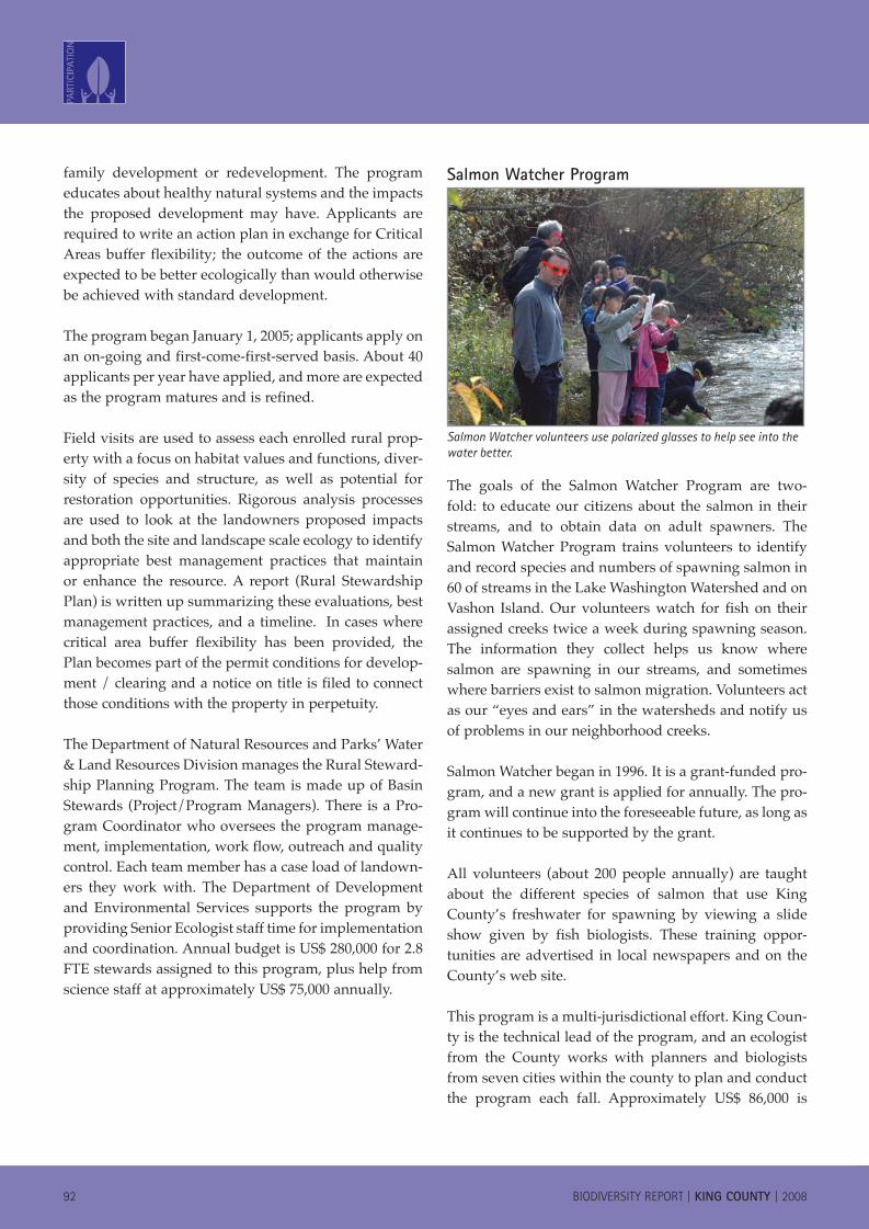
Salmon Watcher Program
Salmon Watcher volunteers use polarized glasses to help see into the water better.
The goals of the Salmon Watcher Program are two-fold: to educate our citizens about the salmon in their streams, and to obtain data on adult spawners. The Salmon Watcher Program trains volunteers to identify and record species and numbers of spawning salmon in 60 of streams in the Lake Washington Watershed and on Vashon Island. Our volunteers watch for fish on their assigned creeks twice a week during spawning season. The information they collect helps us know where salmon are spawning in our streams, and sometimes where barriers exist to salmon migration. Volunteers act as our “eyes and ears” in the watersheds and notify us of problems in our neighborhood creeks.
Salmon Watcher began in 1996. It is a grant-funded pro-gram, and a new grant is applied for annually. The pro-gram will continue into the foreseeable future, as long as it continues to be supported by the grant.
All volunteers (about 200 people annually) are taught about the different species of salmon that use King County’s freshwater for spawning by viewing a slide show given by fish biologists. These training oppor-tunities are advertised in local newspapers and on the County’s web site.
This program is a multi-jurisdictional effort. King Coun-ty is the technical lead of the program, and an ecologist from the County works with planners and biologists from seven cities within the county to plan and conduct the program each fall. Approximately US$ 86,000 is
080310_KCBioDiv_RPT.indd 92 4/1/08 3:46:59 PM

BIODIVERSITY REPORT | KING COUNTY | 2008 93
spent annually in total program costs. One King Coun-ty staff member is the program’s technical lead and volunteer coordinator. This total cost includes value of partnering jurisdiction’s time and volunteer time.
King County basin Stewardship ProgramThe goals of the Basin Stewardship Program are to:
Facilitate the protection and restoration of the county’s most important aquatic and terrestrial habitats Consider landscape (typically stream basin scale) context in prioritizing these effortsEmphasis on habitats and ecological processes rather than individual speciesAccomplish this through close working partner-ships with key landowners, community groups, and government agencies in the county’s stream basins Leverage financial and other resources
The basin steward program was initiated in the early 1990s with the hiring of two basin stewards in stream basins where comprehensive basin planning had been recently completed and has been an ongoing County program since. The program was expanded in the mid-1990s and again in the late 1990s. No end date is projected at this time.
Methods used to raise awareness of the program include:
Working one on one with individual landown-ers to promote resource conservation and solicit partnerships for land protection and habitat restorationCoordination of volunteer habitat restoration projectsEngagement in and comment on critical projects affecting basin healthPresentations to community groups (this has been a lesser area of emphasis in the past several years)
The program is part of the Office of Rural and Resource Programs within the County’s Water and Land Resourc-es Division. The overall organization has a mission of protecting the county’s water and lands so they may be enjoyed safely today and for generations to come.
n
n
n
n
n
n
n
n
The program currently includes the following staff:Basin Stewards (4) – These individuals are responsible for coordinating the implementation of projects in their respective stream basins, typi-cally partnering with other staff from Water and Land Resources, and with other agencies, indi-viduals, and community groups. These individu-als play a strong role in setting operational pri-orities for conservation projects in their basins, and for raising funds to facilitate implementa-tion. Three of these staff are full-time in this role in three separate stream basins; two others are part-time comprising the equivalent of another steward across two additional basins.Rural Stewardship Planning staff (3) – These individuals work with individual landowners to create site stewardship plans for their properties. The plans can provide regulatory flexibility and other incentives to encourage landowners to bal-ance their site development goals with sustain-able approaches to protecting and enhancing the natural resources on their property. Two of these staff are full-time. Two others are part-time creat-ing the equivalent of a third staff person.King County Greenprint and Mitigation Reserves Program Manager (1) – This individual is responsible for managing the Greenprint project, described in detail elsewhere in this report. This individual also manages the County’s Mitigation Reserves Program, which directs off-site mitiga-tion for development impacts to relevant sites based on objective resource protection criteria, when on-site mitigation of development impacts is infeasible.
Staff are allocated to project as described above, plus a unit lead who supervises this program and several others. Budget is approximately US$ 900,000 per year in direct costs including labor, plus several million dol-lars in annual implementation dollars coordinated by this program.
n
n
n
080310_KCBioDiv_RPT.indd 93 4/1/08 3:46:59 PM
94 BIODIVERSITY REPORT | KING COUNTY | 2008
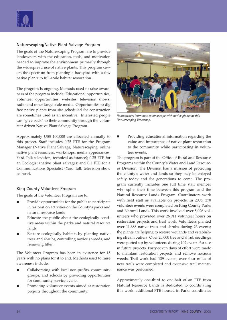
Naturescaping/Native Plant Salvage Program The goals of the Naturescaping Program are to provide landowners with the education, tools, and motivation needed to improve the environment primarily through the widespread use of native plants. This program cov-ers the spectrum from planting a backyard with a few native plants to full-scale habitat restoration.
The program is ongoing. Methods used to raise aware-ness of the program include: Educational opportunities, volunteer opportunities, websites, television shows, radio and other large scale media. Opportunities to dig free native plants from site scheduled for construction are sometimes used as an incentive. Interested people can “give back” to their community through the volun-teer driven Native Plant Salvage Program.
Approximately US$ 100,000 are allocated annually to this project. Staff includes 0.75 FTE for the Program Manager (Native Plant Salvage, Naturescaping, online native plant resources, workshops, media appearances, Yard Talk television, technical assistance); 0.25 FTE for an Ecologist (native plant salvage); and 0.1 FTE for a Communications Specialist (Yard Talk television show co-host).
King County volunteer ProgramThe goals of the Volunteer Program are to:
Provide opportunities for the public to participate in restoration activities on the County’s parks and natural resource landsEducate the public about the ecologically sensi-tive areas within the parks and natural resource landsRestore ecologically habitats by planting native trees and shrubs, controlling noxious weeds, and removing litter.
The Volunteer Program has been in existence for 15 years with no plans for it to end. Methods used to raise awareness include:
Collaborating with local non-profits, community groups, and schools by providing opportunities for community service events. Promoting volunteer events aimed at restoration projects throughout the community.
n
n
n
n
n
Providing educational information regarding the value and importance of native plant restoration to the community while participating in volun-teer events.
The program is part of the Office of Rural and Resource Programs within the County’s Water and Land Resourc-es Division. The Division has a mission of protecting the county’s water and lands so they may be enjoyed safely today and for generations to come. The pro-gram currently includes one full time staff member who splits their time between this program and the Natural Resource Lands Program. Coordinators work with field staff as available on projects. In 2006, 278 volunteer events were completed on King County Parks and Natural Lands. This work involved over 5,026 vol-unteers who provided over 26,911 volunteer hours on restoration projects and trail work. Volunteers planted over 11,688 native trees and shrubs during 23 events; the plants are helping to restore wetlands and establish-ing stream buffers. Over 25,000 tree and shrub seedlings were potted up by volunteers during 102 events for use in future projects. Forty-seven days of effort were made to maintain restoration projects and remove noxious weeds. Trail work had 139 events; over four miles of new trails were completed and extensive trail mainte-nance was performed.
Approximately one-third to one-half of an FTE from Natural Resource Lands is dedicated to coordinating this work; additional FTE housed in Parks coordinates
n
Homeowners learn how to landscape with native plants at this Naturescaping Workshop.
080310_KCBioDiv_RPT.indd 94 4/1/08 3:47:02 PM

BIODIVERSITY REPORT | KING COUNTY | 2008 95
volunteers on active parks. Cost of the Program is about US$ 50,000 annually. Value of volunteer time in labor cost to King County is US$ 322,932 (equal to approxi-mately 14 FTE’s of Park seasonal workers doing restora-tion projects and trail work).
080310_KCBioDiv_RPT.indd 95 4/1/08 3:47:02 PM
96 BIODIVERSITY REPORT | KING COUNTY | 2008
GLOSSARY
Accretion/accretional: Deposition of material by sedi-mentation. Growth of a beach, spit, or similar feature by the addition of material transported by wind and water; pertaining to a feature formed by such sedimentation.
Accretion shoreform: Areas of the marine shoreline where sediment is deposited or has been deposited in the past. These areas generally have broad backshores, large accumulations of drift logs, and marsh or dune grass vegetation communities. They are frequently part of a lagoon/spit complex and are also frequently found at stream mouths along the marine shorelines. See also “Sand spit.”
Adaptive management: The periodic reappraisal of management goals and activities based on information gathered explicitly to test these goals and activities.
Adfluvial: A life history form whereby fish live and feed in lakes and move to streams and rivers to spawn.
Anadromous: One type of fish life history whereby they migrate from salt water to spawn in fresh water. Salmon of the genus Oncorhynchus are anadromous.
Armoring: The addition of rock, concrete, or other mate-rial along a bank, bluff, or shoreline that is intended to inhibit erosional processes.
Bioaccumulate: Uptake and concentration of materials (especially pollutants) by organisms.
Bluff: A high steep bank, often formed by erosion from flowing water (along a river) or wave action (along a marine shoreline). See also “Feeder bluff.”
Bond issue: The proposed sale of financial bonds to fund public infrastructure such as parks, roadways, sta-diums. A bond issue may require approval by a vote of the citizens of the jurisdiction issuing the bonds.
Bottomland: The low-lying land along a river; the floodplain.
Bulkhead: A retaining wall along a shoreline intended to inhibit the effects of wave erosion.
Caddisfly: An aquatic insect of the family Trichoptera.
Cascade: A series of small, short waterfalls over steep bedrock or boulders.
Clearcut: A method of harvesting timber whereby all the trees from an area are taken (see “Selective cut” for contrast).
Code: A set of rules, regulations, and standards promul-gated by the County.
Conservation futures: A Washington State program that allows property taxes to be levied by local govern-ments for acquiring conservation lands and easements.
Corvid: Members of the family Corvidae. Includes the ravens, crows, jays, and magpies.
Dike: An embankment of earth and rock built to pre-vent floods. Also see “Levee.”
Ecotone: The overlap or transition zone between two plant or animal communities.
Endangered Species Act: Passed by the US Congress in 1973, the ESA provides “a means whereby the ecosys-tems upon which [endangered and threatened species] depend may be conserved”. The act recognizes two categories of species: threatened species—those likely to become endangered in the foreseeable future; and endangered species—those likely to become extinct in all or some portion of their range.
Estuarine wetland: A wetland with a salt-water influ-ence.
Eutrophic: Having high primary productivity. This term usually refers to a lake; In King County, eutrophic lakes are characterized by an accumulation of nutrients that support a dense growth of algae and other organ-isms (the primary producers).
Exotic species: Not native; a species that has been intro-duced into an area or ecosystem. These “introductions” may be intentional by humans or they may occur natu-rally as a result of changes on the landscape wrought
080310_KCBioDiv_RPT.indd 96 4/1/08 3:47:03 PM
BIODIVERSITY REPORT | KING COUNTY | 2008 97
by humans. Not all exotic species are invasive. See also “Introduced species” and “Invasive species.”
Extant: In existence; still existing. Extant is the opposite of extinct.
Extinct: No longer living or existing. An extinct species has been completely extirpated.
Extirpated: No longer living or existing in a region of former range. A species that is extirpated from an area may also be extinct.
Federal land: Land owned by the federal government. In King County these lands are typically U.S. Forest Service lands.
Feeder bluff: Also known as sea cliffs and coastal bluffs, these are bluffs along the marine shoreline that are actively contributing, or feeding, sediment to beaches. Bluff sediment is the primary source of beach sediment in Puget Sound, whereas rivers and streams are a sec-ondary source (Keuler 1988). See also “Bluff.”
Fen: A grass, sedge, or reed-dominated peatland, often with some shrub cover.
Fluvial: A life history form whereby fish live and feed in larger rivers and spawn in small streams and tributar-ies. In the Pacific Northwest, some species of trout have this life history. Some species of lamprey may also have this life history.
Forest Plantation: An area cultivated for the produc-tion of trees for commercial harvest; a tree farm. Forest plantations in King County generally use monotypical stands of native species, particularly Douglas fir or Western hemlock, as their species of choice.
Glacial flour: Clay-sized particles of rock, generated by glacial erosion, and suspended in river water, such that the water appears cloudy.
Granitics: Pertaining to granite, especially to the granite rock underlying the Cascade Mountains in northeast King County.
Hedgerow: A line of shrubby vegetation usually mark-ing a field boundary. In King County, hedgerows would be found in agricultural areas.
Herptiles: Collectively, amphibians and reptiles. Also called “herps.”
Introduced species: A species intentionally or uninten-tionally brought into an ecosystem by humans. Not all introduced species become invasive, but all introduced species are non-native, or exotic. See also “Exotic spe-cies” and “Invasive species.”
Invasive species: A species of plant or animal that encroaches from one area or ecosystem into another. Exotic species are more likely to be invasive, but some native species may also become invasive given the right conditions. See also “Exotic species” and “Introduced species.”
Kettle lake: A depression created by partially buried glacial ice blocks as they melted; the depression then filled with water to become a lake.
Lacustrine wetland: A wetland type that is found along the margin of a lake.
Levee: A dike or embankment along a stream or river that is intended to stop water from reaching the flood-plain and stop natural erosion processes. See also “Dike.”
Marine wetland: Wetlands along ocean coasts; salt marshes and vegetated intertidal areas.
Mesotrophic: Having intermediate levels of primary productivity.
Monotypic: Having only one species present.
Moraine: An accumulation of boulders, stones, gravel, sand, or other debris carried and deposited by the plow-ing-like action of a glacier.
Nano-plankton: Minute planktonic organisms with a body diameter between 2 and 20 µm.
080310_KCBioDiv_RPT.indd 97 4/1/08 3:47:03 PM
98 BIODIVERSITY REPORT | KING COUNTY | 2008
Resident: A life history form whereby the fish remain in small streams throughout its lifetime. In the Pacific Northwest, some species of trout have this life history. Many non-salmonids, including sculpins, also have this life history.
Riparian: Pertaining to the banks or margins of streams, rivers, lakes, and marine waters.
Riverine wetland: A wetland along the margin of a river or stream.
Revetment: A facing of stone, concrete, or other material placed along a scarp, embankment, or shoreline that is intended to inhibit natural processes such as erosion by waves or currents.
Salmonids: Members of the family Salmonidae, which includes the salmon, trout, whitefish, and char.
Sand spit: A point of land or a narrow shoal projecting into a body of water and composed of loose sediment. See “accretion shoreform.”
Selective cut: A technique of harvesting trees whereby only certain “selected” trees are taken from the forest stand.
Semelparous: A fish that spawns only a single time in its life. With this life history, after the fish spawn, they protect the nest as long as possible until they die.
Shelterbelt: A vegetated windbreak. An area of trees planted to protect fields and buildings from wind and weather. See also “Hedgerow.”
Sound: Short for Puget Sound. See also “Puget Sound.”
Species of Concern: Species of Concern in Washington include those species listed as State Endangered, State Threatened, State Sensitive, or State Candidate, as well as species listed or proposed for listing by the U.S. Fish and Wildlife Service or the National Marine Fisheries Service.
Neomycid: A freshwater opossum shrimp. A member of the family Mysidacea. An almost exclusively marine family except for three species.
Neotropical: The zoogeographical region comprising South America, West Indies, and Central America south of the Mexican Plateau.
Neotropical migrant: A bird that nests in temperate regions and migrates to the Neotropical faunal region during the non-breeding season.(Martin and Finch 1995; Johnson and O’Neill 2001).
Non-native species: A species not indigenous to the ecosystem under consideration. See also “Exotic spe-cies.”
Oldfield: An abandoned pasture or tilled field that has been overtaken by grasses, herbs, and shrubs.
Oligotrophic: Having low primary productivity. A lake with very few nutrients.
Oxbow lake: A lake formed by the cutoff of a meander bend of a river. So-called because of its crescent shape.
Palustrine wetland: A marsh; a shallow water wetland.
Peatland: Bogs, fens, and swamps where peat has accu-mulated.
Phenology: Study of the temporal aspects of natural phenomenon; especially of the timing of life history events.
Pico-plankton: Planktonic organisms between 0.2 and 2.0 µm.
Puget Sound: The body of saltwater occupying the central portion of the regional topographic depression known as the Puget Lowland. Puget Sound lies between the Olympic Mountains and the Cascade Mountains of Washington State. The Sound is approximately 130 km (80 miles) long, has about 3,220 km (2,000 miles) of shoreline, and is 280 meters (920 feet) at its deepest.
080310_KCBioDiv_RPT.indd 98 4/1/08 3:47:03 PM

BIODIVERSITY REPORT | KING COUNTY | 2008 99
State Sensitive species: Any wildlife species native to the state of Washington that is vulnerable or declin-ing and is likely to become endangered or threatened throughout a significant portion of its range within the state without cooperative management or remov-al of threats. State Sensitive plant species are those plants vulnerable or declining and which could become Endangered or Threatened in the state.
Talus: An area of dislodged rock fragments accumu-lated at the base of a steep slope or cliff, where the cliff may or may not still be present.
Timberlands: Forests that are managed for the harvest of saleable timber.
Tree farm: A forest plantation.
Wilderness Area: In the United States, an area of the landscape set aside by law for its natural value. Wil-derness areas are to remain undeveloped and without roads.
Windthrow: The toppling of trees by wind; most often used in reference to the effect on timberlands.
080310_KCBioDiv_RPT.indd 99 4/1/08 3:47:03 PM
�00 BIODIVERSITY REPORT | KING COUNTY | 2008
PRImARY SOURCES
Boersma, P.D., S.H. Reichard, and A.N. Van Buren. 2006. Invasive Species in the Pacific Northwest. University of Washington Press, Seattle, Wash-ington.
Boumans, R., R. Costanza, M. Wilson, and S. Liu. 2004. Integrated Assessment and valuation of ecosystem goods and services provided by coastal systems. Biology and Environment: Proceedings of the Royal Irish Academy, Dub-lin, Ireland.
Franklin, J. F. and C.T. Dyrness. 1973. Natural Veg-etation of Oregon and Washington. US Forest Service Gen. Tech. Report PNW-8. US Dept. of Agriculture.
Green/Duwamish and Central Puget Sound Water-shed/Water Resource Inventory Area 9 Steer-ing Committee. 2005. Salmon Habitat Plan: Making our Watershed Fit for a King. King County Water and Land Resources Division, Seattle, King County, Washington.
Johnson, D., and T. O’Neil, eds. Wildlife-Habi-tat Relationships in Oregon and Washington. Oregon State University Press, Corvallis, OR. 736pp.
Kruckeberg, A.R. 1991. The Natural History of Puget Sound Country. University of Washing-ton Press, Seattle, Washington.
Pater, D.E., S.A. Bryce, T.D. Thorson, J. Kagan, C. Chappell, J.M. Omernik, S.H. Azevedo, and A.J. Woods. 1998. Ecoregions of Western Wash-ington and Oregon. (Map poster). U.S. Geologi-cal Survey, Reston, VA.
Shared Strategy for Puget Sound. 2006. Puget Sound Salmon Recovery Plan. Seattle, Wash-ington.
Wydoski, R.S. and R.R. Whitney. 2003. Inland Fishes of Washington, 2nd Edition. American Fisheries Society and the University of Wash-ington Press. Seattle, Wa.
mAP SOURCES 1. Washington Ornithological Society. 2006. Bird Checklist for King County. Available at http://www.wos.org/CountyList.htm
2. WDFW. 1999. Washington Gap Data Products, web site: http://wdfw.wa.gov/wlm/gap/dataprod.htm
3. Wydoski, R.S., and R.R. Whitney. 2003. Inland Fishes of Washington. University of Washington Press, Seattle, WA.
4. Washington Native Plant Society: http://www.wnps.org/plant_lists/counties/king/king_county.html
080310_KCBioDiv_RPT.indd 100 4/1/08 3:47:04 PM

ImprintLAB Biodiversity Report: King County
PublisherKing County Department of Natural Resources and Parks
AuthorsRobert Fuerstenberg, Senior Ecologist, Principal Author
Jennifer Vanderhoof, Ecologist, Principal AuthorJonathan Frodge, Limnologist, AuthorKathryn Gellenbeck, Analyst, Author
Kollin Higgins, Ecologist, AuthorKlaus Richter, Senior Ecologist, Author
Kim Stark, Marine Biologist, Author
Cover PhotosNed Ahrens
Bob FuerstenbergRay HellerKim Stark
Jennifer Vanderhoof
Layout and printLaurel Preston, DNRP GIS, Visual Communications & Web Unit
King County Department of Natural Resources and Parks
Copyright© King County, [2007] and ICLEI Africa Secretariat, [2007]
All rights reserved. No part of this reportmay be reproduced or copied in any form
or by any means without the writtenpermission of King County and ICLEI Africa Secretariat.
Printed in the USA
Obtainable fromElectronic copies obtainable upon request from:
Local Action for Biodiversity, ICLEI Africa SecretariatE-mail: [email protected]
Website: www.iclei.org/lab
Hard copies available upon request from:
File Location:King County Water and Land Resources Division GIS, Visual Communications & Web Unit Archives
0802_KCbiodivRPT/ LPRE
Local Action for BiodiversityPO Box 16548
Vlaeberg8018
South Africa
King County201 South Jackson Street, Suite 600Seattle, WA98104USA
w w w . i c l e i . o r g / l a b
L O C A L A C T I O N F O R B I O D I V E R S I T YPA R T N E R S