Embed Size (px)
Citation preview

Knowledge as CI: Toward Geographic Knowledge Systems
Rob RaskinNASA/JPL

Data to Information to Knowledge
Data Information Knowledge
Basic Elements Bytes Numbers Models FactsStorage File Database GIS FTC Ontology MindVolume High LowDensity Low HighServices Save Discover Visualize Overlay Infer Understand Predict
Syntax Semantics
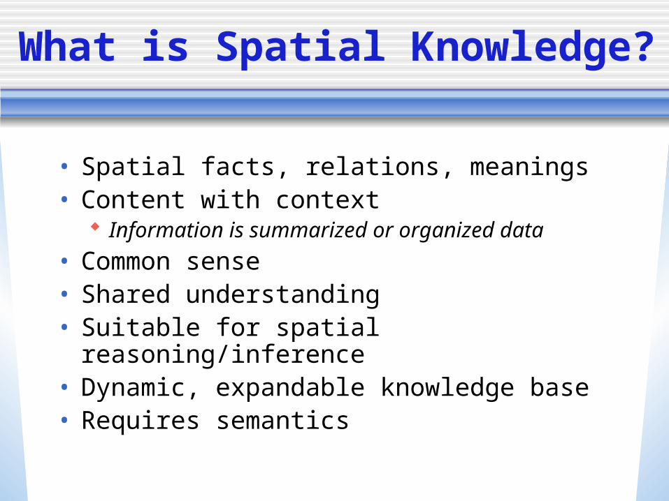
What is Spatial Knowledge?
• Spatial facts, relations, meanings• Content with context
Information is summarized or organized data
• Common sense• Shared understanding• Suitable for spatial reasoning/inference• Dynamic, expandable knowledge base• Requires semantics

Ontology: Knowledge as Cyberinfrastructure
• Context Shared understanding of concepts
• Content A dictionary readable both by computers and
humans
• Form A namespace (URL/URI/pointer) containing an
authoritative declaration of a concept
• Authority Anyone… but the best will win out We will vote with our fingers

Enterprise-wide Ontology
• Smart discovery Google does not understand meaning of
terms Neither does ArcGIS
• Smart integration• Knowledge commons
Assist education

Why point to an ontology?
• Enable machine-to-machine communication
• Associate data with its context• Remove ambiguity
Temperature anomaly: relative to what climatological average?
Remotely sensed feature measured how
Spring (season) or Spring (water source)

Use Case: Global Warming Query
Find data which demonstrates global warming at high latitudes during summertime and plot warming rate.
Extract information from the use-case - encode knowledge Translate this into a complete query for data - inference and
integration of data from instruments, indices and models
“Global warming”= Trend of increasing temperature over large spatial scales
“High latitude”= Latitudes > 60 degrees“Summertime”= June-Aug (NH) and Jan-Mar (SH)“Find data”= Locate datasets using catalogs, then access
and read it“Plot warming rate”= Display temperature vs time

Ontology Representations…
• XML• Triples• DBMS• Visual

Ontology Representation: Triples
Subject-Verb-Object representation
• Flood is a WeatherPhenomena• GeoTIFF is a FileFormat• Soil Type is a PhysicalProperty• Pacific Ocean is a Ocean
• Ocean has substance Water• Sensor measures Temperature

Ontology Representation:
Visual
Atmosphere
AtmosphereLayer
Troposphere
Tropopause
Stratosphere
isUpperBoundaryOf isLowerBoundaryOf
subClassOfsubClassOf
partOf
PlanetaryLayer
partOf
3DLayer
subClassOf
upperBoundary=50 km
lowerBoundary=15 km
primarySubstance=“air”
sameAs=“LowerAtmosphere”

Plate tectonics - before
Plate Tectonics Ontology

Ontology of an Organization
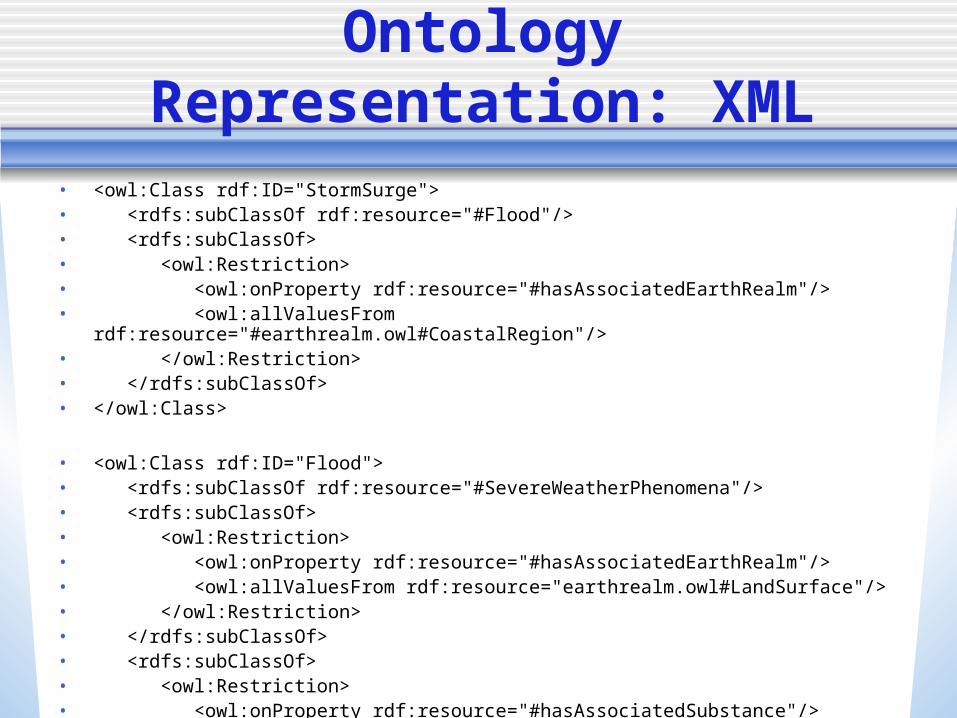
• <owl:Class rdf:ID="StormSurge">• <rdfs:subClassOf rdf:resource="#Flood"/>• <rdfs:subClassOf>• <owl:Restriction>• <owl:onProperty rdf:resource="#hasAssociatedEarthRealm"/>• <owl:allValuesFrom rdf:resource="#earthrealm.owl#CoastalRegion"/>• </owl:Restriction>• </rdfs:subClassOf>• </owl:Class>
• <owl:Class rdf:ID="Flood">• <rdfs:subClassOf rdf:resource="#SevereWeatherPhenomena"/>• <rdfs:subClassOf>• <owl:Restriction>• <owl:onProperty rdf:resource="#hasAssociatedEarthRealm"/>• <owl:allValuesFrom rdf:resource="earthrealm.owl#LandSurface"/>• </owl:Restriction>• </rdfs:subClassOf>• <rdfs:subClassOf>• <owl:Restriction>• <owl:onProperty rdf:resource="#hasAssociatedSubstance"/>• <owl:allValuesFrom rdf:resource="substance.owl#LiquidWater"/>• </owl:Restriction>• </rdfs:subClassOf>• </owl:Class>
Ontology Representation: XML

Ontology Languages in XML: RDF and OWL
• Use of standard languages make it easy to extend (specialize) concepts developed by others Consistent with how we learn - incrementally
Knowledge passed down to future generations Continues web paradigm - anyone can be an author
• W3C languages specialize XML Resource Description Formulation (RDF)
Standardizes: class, subclass, property, subproperty Ontology Web Language (OWL)
Standardizes: transitive functions, inverse relations, cardinality, etc.
• Open world assumption Facts not explicitly stated are not assumed to be false In contrast, DBMS world uses closed world assumptions
Tuples are the truth, the whole truth, and nothing but the truth

SWEET
• Semantic Web for Earth and Environmental Terminology (SWEET)
• Upper-level concept space for Earth system science
• Includes concepts of: Numerics Space Time Earth system science Data and information Data and information services

Why use an Upper-Level Ontology?
• Many common concepts used across spatial disciplines (such as properties of the Earth surface) Provides common definitions for terms used in multiple
disciplines or communities Provides common language in support of community and
multidisciplinary activities Provides common “properties” (relations) for tool
developers
• Reduced burden (and barrier to entry) on creators of specialized domain ontologies Only need to create ontologies for incremental knowledge

Non-LivingSubstances
LivingSubstances
PhysicalProcesses
Earth Realm
PhysicalProperties
Time
NaturalPhenomena
Human Activities
Integrative Ontologies
Space
Data
Faceted Ontologies
Units
Numerics
SWEET 1.0 Ontologies

SWEET Spatial Ontologies
• Objects 0-D, 1-D, 2-D, and 3-D
• Coordinate systems• Relations
Above, inside, adjacent, etc.
• Fuzzy concepts “near”
• Spatial statistics• Features

SWEET 2.0 Modular Design
Math, Time, Space
Basic Science
Geoscience Processes
Geophysical Phenomena
Applicationsimportation
• Supports easy extension by domain specialists
• Organized by subject (theoretical to applied)
• Reorganization of classes, but no significant changes to content
• No longer one-to-one relation of facet to file

SWEET 2.0 New Features
• Organized by subject Makes it easy for domain specialists to
add new modules• Smaller, modular ontologies
Unidirectional import• 12 large ontologies -> 100 small
ontologies

SWEET 2.0 Ontologies
AbstractTo Applied

Characteristic Level of Abstractions
• Any concept has a characteristic level of abstraction How theoretical is it?
• If more than one characteristic level… repeat it Words are commonly defined in
dictionaries with multiple meanings

Community Agreements:How to Optimally Use OWL
• Reduce quadruples/quintuples to triples Interval quantities
hasLowerBound, hasUpperBound, hasUnit
• Fuzzy concepts “nearlySameAs” relatedConcept connects siblings or other concepts that
might be closely related similarity matrix provides more precise support for
search results ranking
• Ensembles pdf representations

Collaborative Ontology Development

Ontology Development Tools: CMAP
• Free, downloadable tool for knowledge representation and ontology development
• Visual language with input/export to OWL Supports subset of OWL language
• http://cmap.ihmc.us/coe

Resources
• SWEET http://sweet.jpl.nasa.gov
• Ontology development/sharing site http://PlanetOnt.org