Embed Size (px)
DESCRIPTION
GALLERI BYGDØY ALLÉ Exhibition Catalogue of maps
Citation preview
7/5/2014 Welcome to Kunstantikvariat Pama AS
http://www.antiquemaps.no/mapsviews.php?category=maps%2Fviews&subcategory=maps&subsubcategory=Maps%20of%20the%20World%20and%20the%20… 1/15
HOME
ABOUT US
MAPS/VIEWS
PAINTINGS
DECORATIVE PRINTS
BOOKS
EXHIBITION CATALOGUE
LINKS
Maps/Views
Maps of the World and the Continents
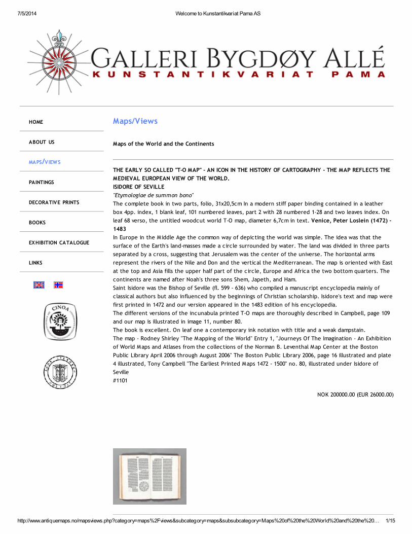
THE EARLY SO CALLED "T-O MAP" - AN ICON IN THE HISTORY OF CARTOGRAPHY - THE MAP REFLECTS THE
MEDIEVAL EUROPEAN VIEW OF THE WORLD.
ISIDORE OF SEVILLE
"Etymologiae de summon bono"
The complete book in two parts, folio, 31x20,5cm In a modern stiff paper binding contained in a leather
box 4pp. index, 1 blank leaf, 101 numbered leaves, part 2 with 28 numbered 1-28 and two leaves index. On
leaf 68 verso, the untitled woodcut world T-O map, diameter 6,7cm in text. Venice, Peter Loslein (1472) -
1483
In Europe in the Middle Age the common way of depicting the world was simple. The idea was that the
surface of the Earth's land-masses made a circle surrounded by water. The land was divided in three parts
separated by a cross, suggesting that Jerusalem was the center of the universe. The horizontal arms
represent the rivers of the Nile and Don and the vertical the Mediterranean. The map is oriented with East
at the top and Asia fills the upper half part of the circle, Europe and Africa the two bottom quarters. The
continents are named after Noah's three sons Shem, Japeth, and Ham.
Saint Isidore was the Bishop of Seville (fl. 599 - 636) who compiled a manuscript encyclopedia mainly of
classical authors but also influenced by the beginnings of Christian scholarship. Isidore's text and map were
first printed in 1472 and our version appeared in the 1483 edition of his encyclopedia.
The different versions of the incunabula printed T-O maps are thoroughly described in Campbell, page 109
and our map is illustrated in image 11, number 80.
The book is excellent. On leaf one a contemporary ink notation with title and a weak dampstain.
The map - Rodney Shirley "The Mapping of the World" Entry 1, "Journeys Of The Imagination - An Exhibition
of World Maps and Atlases from the collections of the Norman B. Leventhal Map Center at the Boston
Public Library April 2006 through August 2006" The Boston Public Library 2006, page 16 illustrated and plate
4 illustrated, Tony Campbell "The Earliest Printed Maps 1472 - 1500" no. 80, illustrated under Isidore of
Seville
#1101
NOK 200000.00 (EUR 26000.00)
7/5/2014 Welcome to Kunstantikvariat Pama AS
http://www.antiquemaps.no/mapsviews.php?category=maps%2Fviews&subcategory=maps&subsubcategory=Maps%20of%20the%20World%20and%20the%20… 2/15
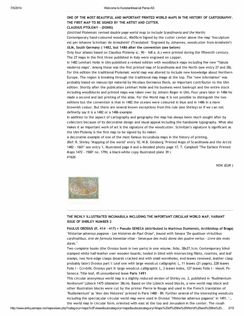
ONE OF THE MOST BEAUTIFUL AND IMPORTANT PRINTED WORLD MAPS IN THE HISTORY OF CARTOGRAPHY.
THE FIRST MAP TO BE SIGNED BY THE ARTIST AND CUTTER.
CLAUDIUS PTOLEMY - (DONIS)
(Untitled Ptolemaic revised double page world map to include Scandinavia and the North)
Contemporary hand-coloured woodcut, 40x55cm Signed by the cutter center above the map "Insculptum
est per Iohanne Schnitzer de Armszheim" (Translated: "Engraved by Johannes, woodcutter from Armsheim")
ULM, South Germany ( 1482, but 1486 after the convention (see below)
Only four atlases based on Claudius Ptolemy (c. 90 - 168 a. d.) were printed during the fifteenth century.
The 27 maps in the first three published in Italy were engraved on copper.
In 1482 Leinhart Holle in Ulm published a revised edition with woodblock maps including five new "Tabula
moderna maps". Among these was the first printed map of Scandinavia and the North (see entry 27 and 28).
For this edition the traditional Ptolemaic world map was altered to include new knowledge about Northern
Europe. The region is breaking through the traditional map image at the top. The "new information" was
probably based on manuscript material by Nicolaus Germanus Donis, an important contributor to the Ulm
edition. Shortly after the publication Leinhart Holle and his business went bankrupt and the entire stock
including woodblocks and printed maps was taken over by Johann Reger in Ulm. Four years later in 1486 he
made a second and last printing of the atlas. For the World map it is not possible to distinguish the two
editions but the convention is that in 1482 the oceans were coloured in blue and in 1486 in a more
brownish colour. But there are several known exceptions from this rule (see Shirley) so if we can not
definetly say it is a 1482 or a 1486 example.
In addition to the aspect of cartography and geography the map has always been much sought after by
collectors because of its decorative design and visual appeal including the handsome typography. What also
makes it an important work of art is the signature of the woodcutter. Schnitzer's signature is significant as
the Ulm Ptolemy is the first map to be signed by its maker.
A decorative example of one of the most famous incunabula maps in the history of printing.
(Ref: R. Shirley "Mapping of the world" entry 10, W.B. Ginsberg "Printed Maps of Scandinavia and the Arctic
1482 - 1601" see entry 1, illustrated page 6 and a detailed photo page 17, T. Campbell "The Earliest Printed
Maps 1472 - 1500" no. 179ii, a black-white copy illustrated plate 39 )
#1626
NOK (EUR )
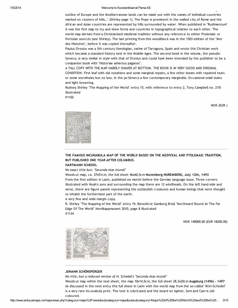
THE RICHLY ILLUSTRATED INCUNABULA INCLUDING THE IMPORTANT CIRCULAR WORLD MAP, VARIANT
ISSUE OF SHIRLEY NUMBER 2
PAULUS OROSIUS (fl. 414 - 417) + Pseudo SENECA (Attributed to Martinus Dumiensis, Archbishop of Braga)
"Historiae adversus paganos - Les histoires de Paul Orose", bound with Senaca "De quattuor virtutibus
cardinalibus, sive de formula honestae vitae - Senecque des motz dorez des quatre vertus - Livre des mots
dorés."
Two complete books (the Orosius book in two parts) in one volume, folio, 38x27,1cm. Contemporary blind-
stamped white half-leather over wooden boards, tooled in blind with intersecting fillets, rosettes, and leaf
stamps, two fore-edge clasps (boards cracked and with small wormholes, end-leaves renewed, leather clasp
probably later) Orosius part I: Leaf one with large woodcut calligraphic L, 11 leaves (21 pages), 228 leaves
Folio I - Ccrrbiiii, Orsoius part II: large woodcut calligraphic L, 3 leaves index, 127 leaves Folio I - vixxvii. Ps-
Seneca: Title leaf, 45 unnumbered leave Paris 1491
This circular anonymous world map is a slightly reduced version of Shirley no. 2, published in "Rudimentum
Novitorum" Lübeck 1475 (diameter 38cm). Based on the Lübeck wood blocks, a new world map block and
other illustration blocks were cut by the printer Pierre le Rouge and used in the French translation of
"Rudiementum" as "Mer des Histoires" printed in Paris 1488 - 89. Further several of the interesting woodcuts
including the spectacular circular world map were used in Orosius' "Historiae adversus paganos" in 1491. "…
the world map in circular form, oriented with east at the top and Jerusalem in the center. The rough
7/5/2014 Welcome to Kunstantikvariat Pama AS
http://www.antiquemaps.no/mapsviews.php?category=maps%2Fviews&subcategory=maps&subsubcategory=Maps%20of%20the%20World%20and%20the%20… 3/15
the world map in circular form, oriented with east at the top and Jerusalem in the center. The rough
outline of Europe and the Mediterranean lands can be made out with the names of individual countries
marked on clusters of hills…" (Shirley page 1). The Pope is prominent in the walled city of Rome and the
African and Asian countries are represented by hills surrounded by water. When published in "Rudimentum"
it was the first map to try and show forms and countries in topographical relation to each other. The
world map derives from a Christianised medieval tradition without any reference to either Ptolemaic or
Portolan sources (see Shirley). The last printing from this woodblock was in the 1503 edition of the "Mer
des Histoires", before it was copied thereafter.
Paulus Orosius was a 5th century theologian, native of Tarragona, Spain and wrote this Christian work
which became a standard history text in the Middle Ages. The second book in the volume, the pseudo-
Seneca, is very similar in style with that of Orosius and could have been intended by the publisher to be a
companion book with "Historiae adversus paganos".
A TALL COPY WITH THE MAP HARDLY SHAVED AT BOTTOM. THE BOOK IS IN VERY GOOD AND ORIGINAL
CONDITION. First leaf with old notations and some marginal repairs, a few other leaves with repaired tears
or some wormholes but no loss. In the ps-Seneca a few contemporary marginalia. Occasional small stains
and light browning.
Rodney Shirley "The Mapping of the World" entry 15, with reference to entry 2, Tony Campbell no. 215i
illustrated
#1102
NOK (EUR )
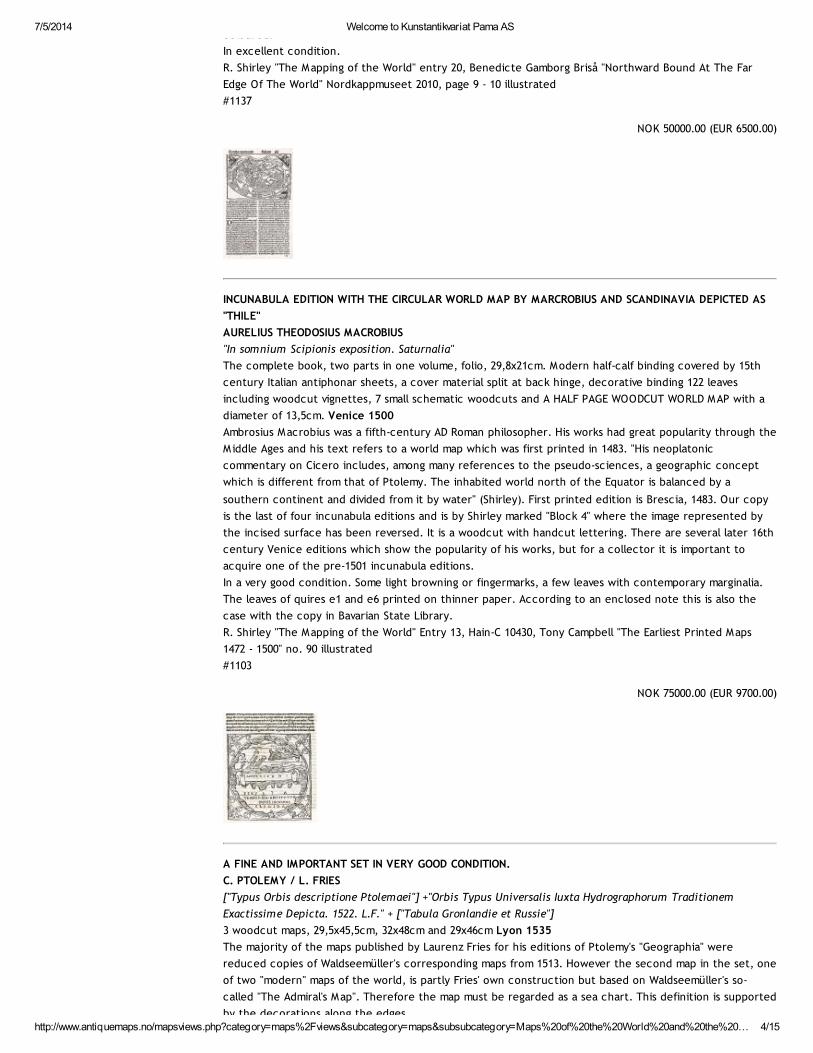
THE FAMOUS INCUNABULA MAP OF THE WORLD BASED ON THE MEDIVEAL AND PTOLEMAIC TRADITION,
BUT PUBLISHED ONE YEAR AFTER COLUMBUS.
HARTMANN SCHEDEL
No exact title but: "Secunda etas mundi"
Woodcut map, ca. 37x51cm, the full sheet 46x60,5cm Nuremberg NUREMBERG, July 12th, 1493
From the first edition in Latin, published six month before the German language issue. Three corners
illustrated with Noah's sons and surrounding the map there are 12 windheads. On the left hand-side and
verso, there are figure panels representing the outlandish creatures and human beings that were thought
to inhabit the furthermost part of the earth.
A very fine and wide-margin copy.
R. Shirley "The Mapping of the World" entry 19, Benedicte Gamborg Briså "Northward Bound At The Far
Edge Of The World" Nordkappmuseet 2010, page 8 illustrated
#1134
NOK 140000.00 (EUR 18200.00)
JOHANN SCHÖNSPERGER
No title, but a reduced version of H. Schedel's "Secunda etas mundi"
Woodcut map within the text sheet, the map 10x14,5cm, the full sheet 28,3x20cm Augsburg (1496) - 1497
As discussed in the next entry this full sheet in Latin with the world map from the so-called "M ini-Schedel"
is a very rare incunabula print. The text is rubricated and the beard on Iaphet, Sem and Cam is old-
coloured.
7/5/2014 Welcome to Kunstantikvariat Pama AS
http://www.antiquemaps.no/mapsviews.php?category=maps%2Fviews&subcategory=maps&subsubcategory=Maps%20of%20the%20World%20and%20the%20… 4/15
coloured.
In excellent condition.
R. Shirley "The Mapping of the World" entry 20, Benedicte Gamborg Briså "Northward Bound At The Far
Edge Of The World" Nordkappmuseet 2010, page 9 - 10 illustrated
#1137
NOK 50000.00 (EUR 6500.00)
INCUNABULA EDITION WITH THE CIRCULAR WORLD MAP BY MARCROBIUS AND SCANDINAVIA DEPICTED AS
"THILE"
AURELIUS THEODOSIUS MACROBIUS
"In somnium Scipionis exposition. Saturnalia"
The complete book, two parts in one volume, folio, 29,8x21cm. Modern half-calf binding covered by 15th
century Italian antiphonar sheets, a cover material split at back hinge, decorative binding 122 leaves
including woodcut vignettes, 7 small schematic woodcuts and A HALF PAGE WOODCUT WORLD MAP with a
diameter of 13,5cm. Venice 1500
Ambrosius Macrobius was a fifth-century AD Roman philosopher. His works had great popularity through the
Middle Ages and his text refers to a world map which was first printed in 1483. "His neoplatonic
commentary on Cicero includes, among many references to the pseudo-sciences, a geographic concept
which is different from that of Ptolemy. The inhabited world north of the Equator is balanced by a
southern continent and divided from it by water" (Shirley). First printed edition is Brescia, 1483. Our copy
is the last of four incunabula editions and is by Shirley marked "Block 4" where the image represented by
the incised surface has been reversed. It is a woodcut with handcut lettering. There are several later 16th
century Venice editions which show the popularity of his works, but for a collector it is important to
acquire one of the pre-1501 incunabula editions.
In a very good condition. Some light browning or fingermarks, a few leaves with contemporary marginalia.
The leaves of quires e1 and e6 printed on thinner paper. According to an enclosed note this is also the
case with the copy in Bavarian State Library.
R. Shirley "The Mapping of the World" Entry 13, Hain-C 10430, Tony Campbell "The Earliest Printed Maps
1472 - 1500" no. 90 illustrated
#1103
NOK 75000.00 (EUR 9700.00)
A FINE AND IMPORTANT SET IN VERY GOOD CONDITION.
C. PTOLEMY / L. FRIES
["Typus Orbis descriptione Ptolemaei"] +"Orbis Typus Universalis Iuxta Hydrographorum Traditionem
Exactissime Depicta. 1522. L.F." + ["Tabula Gronlandie et Russie"]
3 woodcut maps, 29,5x45,5cm, 32x48cm and 29x46cm Lyon 1535
The majority of the maps published by Laurenz Fries for his editions of Ptolemy's "Geographia" were
reduced copies of Waldseemüller's corresponding maps from 1513. However the second map in the set, one
of two "modern" maps of the world, is partly Fries' own construction but based on Waldseemüller's so-
called "The Admiral's Map". Therefore the map must be regarded as a sea chart. This definition is supported
by the decorations along the edges.
7/5/2014 Welcome to Kunstantikvariat Pama AS
http://www.antiquemaps.no/mapsviews.php?category=maps%2Fviews&subcategory=maps&subsubcategory=Maps%20of%20the%20World%20and%20the%20… 5/15
by the decorations along the edges.
On the third map, the second "modern" one, Fries added five thrones of kings, representing those of
Russia, Egypt, Ethiopia, Taprobana (Ceylon), and Mursuli. Above Greenland he put in an image of a
mammoth. The three maps represent some of the earliest world maps available to a collector. The set of
three was published by Michael Servetus. He was some years later burnt at the stake. On Calvin's order
many copies of Servetus's books followed him into the flames. It is supposed that this also included the
1535 atlas edition which made it to a rare book.
The Ptolemy map has a water stain along upper margin.
R. Shirley "The Mapping of the World" Entries 47, 89, and 49
#1140
NOK 90000.00 (EUR 11700.00)
THE VERY RARE FIRST FRIES EDITION OF THE PTOLEMAIC WORLD MAP IN A VERY GOOD CONDITION.
C. PTOLEMY / L. FRIES
"Generale Ptho" ["Typus Orbis descriptione Ptolemaei"]
Woodcut map, 29,5x45,5cm Strasbourg 1522
Based on Martin Waldseemüller's Ptolemaic map of Strasbourg 1513, but redrawn and reduced in size.
Scandinavia has been incorporated in the North. Published in the atlas of Laurenz Fries and printed by
Grüninger. There are later editions of the map with some changes in 1525, 35 and 41, see next number.
Maps from the first Fries edition seldom appear on the market.
Two light damp stains in lower blank margin.
Rodney Shirley "The Mapping of the World" entry 47)
#1139
NOK 38000.00 (EUR 4950.00)
FIRST EDITION MAP WITH NO TEXT VERSO.
( C. PTOLEMY) - GERARD MERCATOR
"Universalis Tabula Iuxta Ptolemaeum"
Contemporary outline-coloured engraving, 34,5x48cm Cologne 1578
"One of the most elegantly engraved of the Ptolemaic World maps…" (Shirley). The map was published in G.
Mercator's revision of Ptolemy's "Geographia" 1578 and later and shows the traditional ancient World. It was
printed as late as 1730, but after 1619 the border was extensively reworked and replaced by allegorical
figures.
The margins partly shaved into the map line, laid down on good paper.
Rodney Shirley "The Mapping of the World" Entry 139)
#1148
NOK 16000.00 (EUR 2100.00)
7/5/2014 Welcome to Kunstantikvariat Pama AS
http://www.antiquemaps.no/mapsviews.php?category=maps%2Fviews&subcategory=maps&subsubcategory=Maps%20of%20the%20World%20and%20the%20… 6/15
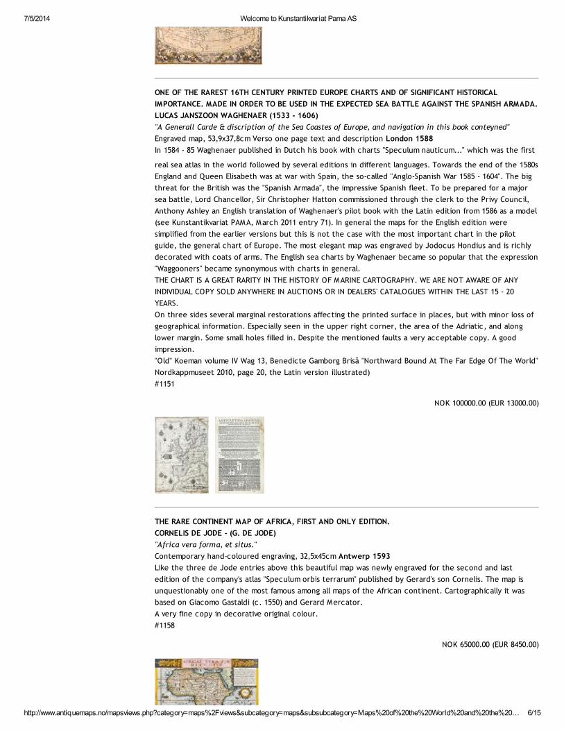
ONE OF THE RAREST 16TH CENTURY PRINTED EUROPE CHARTS AND OF SIGNIFICANT HISTORICAL
IMPORTANCE. MADE IN ORDER TO BE USED IN THE EXPECTED SEA BATTLE AGAINST THE SPANISH ARMADA.
LUCAS JANSZOON WAGHENAER (1533 - 1606)
"A Generall Carde & discription of the Sea Coastes of Europe, and navigation in this book conteyned"
Engraved map, 53,9x37,8cm Verso one page text and description London 1588
In 1584 - 85 Waghenaer published in Dutch his book with charts "Speculum nauticum..." which was the first
real sea atlas in the world followed by several editions in different languages. Towards the end of the 1580s
England and Queen Elisabeth was at war with Spain, the so-called "Anglo-Spanish War 1585 - 1604". The big
threat for the British was the "Spanish Armada", the impressive Spanish fleet. To be prepared for a major
sea battle, Lord Chancellor, Sir Christopher Hatton commissioned through the clerk to the Privy Council,
Anthony Ashley an English translation of Waghenaer's pilot book with the Latin edition from 1586 as a model
(see Kunstantikvariat PAMA, March 2011 entry 71). In general the maps for the English edition were
simplified from the earlier versions but this is not the case with the most important chart in the pilot
guide, the general chart of Europe. The most elegant map was engraved by Jodocus Hondius and is richly
decorated with coats of arms. The English sea charts by Waghenaer became so popular that the expression
"Waggooners" became synonymous with charts in general.
THE CHART IS A GREAT RARITY IN THE HISTORY OF MARINE CARTOGRAPHY. WE ARE NOT AWARE OF ANY
INDIVIDUAL COPY SOLD ANYWHERE IN AUCTIONS OR IN DEALERS' CATALOGUES WITHIN THE LAST 15 - 20
YEARS.
On three sides several marginal restorations affecting the printed surface in places, but with minor loss of
geographical information. Especially seen in the upper right corner, the area of the Adriatic, and along
lower margin. Some small holes filled in. Despite the mentioned faults a very acceptable copy. A good
impression.
"Old" Koeman volume IV Wag 13, Benedicte Gamborg Briså "Northward Bound At The Far Edge Of The World"
Nordkappmuseet 2010, page 20, the Latin version illustrated)
#1151
NOK 100000.00 (EUR 13000.00)
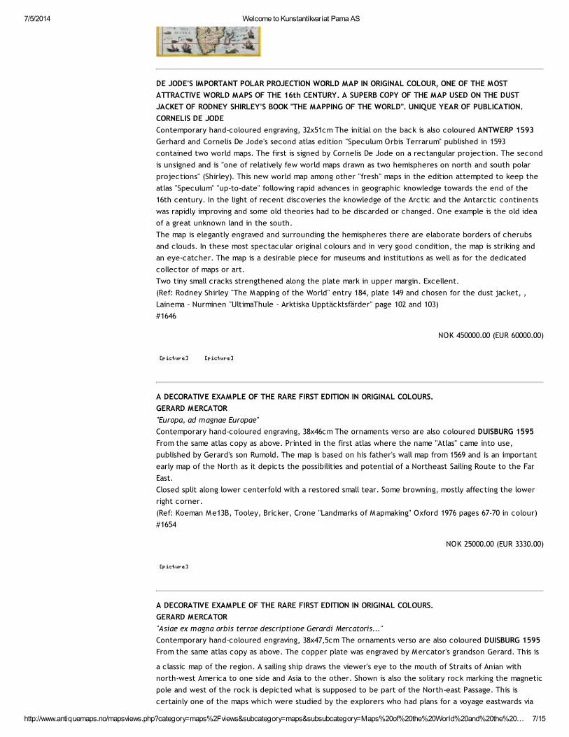
THE RARE CONTINENT MAP OF AFRICA, FIRST AND ONLY EDITION.
CORNELIS DE JODE - (G. DE JODE)
"Africa vera forma, et situs."
Contemporary hand-coloured engraving, 32,5x45cm Antwerp 1593
Like the three de Jode entries above this beautiful map was newly engraved for the second and last
edition of the company's atlas "Speculum orbis terrarum" published by Gerard's son Cornelis. The map is
unquestionably one of the most famous among all maps of the African continent. Cartographically it was
based on Giacomo Gastaldi (c. 1550) and Gerard Mercator.
A very fine copy in decorative original colour.
#1158
NOK 65000.00 (EUR 8450.00)
7/5/2014 Welcome to Kunstantikvariat Pama AS
http://www.antiquemaps.no/mapsviews.php?category=maps%2Fviews&subcategory=maps&subsubcategory=Maps%20of%20the%20World%20and%20the%20… 7/15
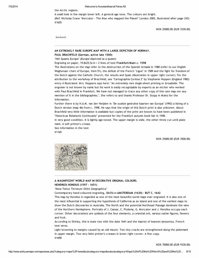
DE JODE'S IMPORTANT POLAR PROJECTION WORLD MAP IN ORIGINAL COLOUR, ONE OF THE MOST
ATTRACTIVE WORLD MAPS OF THE 16th CENTURY. A SUPERB COPY OF THE MAP USED ON THE DUST
JACKET OF RODNEY SHIRLEY'S BOOK "THE MAPPING OF THE WORLD". UNIQUE YEAR OF PUBLICATION.
CORNELIS DE JODE
Contemporary hand-coloured engraving, 32x51cm The initial on the back is also coloured ANTWERP 1593
Gerhard and Cornelis De Jode's second atlas edition "Speculum Orbis Terrarum" published in 1593
contained two world maps. The first is signed by Cornelis De Jode on a rectangular projection. The second
is unsigned and is "one of relatively few world maps drawn as two hemispheres on north and south polar
projections" (Shirley). This new world map among other "fresh" maps in the edition attempted to keep the
atlas "Speculum" "up-to-date" following rapid advances in geographic knowledge towards the end of the
16th century. In the light of recent discoveries the knowledge of the Arctic and the Antarctic continents
was rapidly improving and some old theories had to be discarded or changed. One example is the old idea
of a great unknown land in the south.
The map is elegantly engraved and surrounding the hemispheres there are elaborate borders of cherubs
and clouds. In these most spectacular original colours and in very good condition, the map is striking and
an eye-catcher. The map is a desirable piece for museums and institutions as well as for the dedicated
collector of maps or art.
Two tiny small cracks strengthened along the plate mark in upper margin. Excellent.
(Ref: Rodney Shirley "The Mapping of the World" entry 184, plate 149 and chosen for the dust jacket, ,
Lainema - Nurminen "UltimaThule - Arktiska Upptäcktsfärder" page 102 and 103)
#1646
NOK 450000.00 (EUR 60000.00)
A DECORATIVE EXAMPLE OF THE RARE FIRST EDITION IN ORIGINAL COLOURS.
GERARD MERCATOR
"Europa, ad magnae Europae"
Contemporary hand-coloured engraving, 38x46cm The ornaments verso are also coloured DUISBURG 1595
From the same atlas copy as above. Printed in the first atlas where the name "Atlas" came into use,
published by Gerard's son Rumold. The map is based on his father's wall map from 1569 and is an important
early map of the North as it depicts the possibilities and potential of a Northeast Sailing Route to the Far
East.
Closed split along lower centerfold with a restored small tear. Some browning, mostly affecting the lower
right corner.
(Ref: Koeman Me13B, Tooley, Bricker, Crone "Landmarks of Mapmaking" Oxford 1976 pages 67-70 in colour)
#1654
NOK 25000.00 (EUR 3330.00)
A DECORATIVE EXAMPLE OF THE RARE FIRST EDITION IN ORIGINAL COLOURS.
GERARD MERCATOR
"Asiae ex magna orbis terrae descriptione Gerardi Mercatoris..."
Contemporary hand-coloured engraving, 38x47,5cm The ornaments verso are also coloured DUISBURG 1595
From the same atlas copy as above. The copper plate was engraved by Mercator's grandson Gerard. This is
a classic map of the region. A sailing ship draws the viewer's eye to the mouth of Straits of Anian with
north-west America to one side and Asia to the other. Shown is also the solitary rock marking the magnetic
pole and west of the rock is depicted what is supposed to be part of the North-east Passage. This is
certainly one of the maps which were studied by the explorers who had plans for a voyage eastwards via
the Arctic regions.
7/5/2014 Welcome to Kunstantikvariat Pama AS
http://www.antiquemaps.no/mapsviews.php?category=maps%2Fviews&subcategory=maps&subsubcategory=Maps%20of%20the%20World%20and%20the%20… 8/15
the Arctic regions.
A small hole in the margin lower left. A general age tone. The colours are bright.
(Ref: Nicholas Crane "Mercator - The Man who mapped the Planet" London 2002, illustrated after page 243)
#1655
NOK 25000.00 (EUR 3330.00)
AN EXTREMELY RARE EUROPE MAP WITH A LARGE DEPICTION OF NORWAY.
PAUL BRACHFELD (German, active late 1500)
"Het Spaens Europa" (Europe depicted as a queen)
Engraving on paper, 19,8x25,5cm + 2 lines of text Frankfurt/Main c. 1598
The illustrations on the map refer to the destruction of the Spanish Armada in 1588 (refer to our English
Waghenaer chart of Europe, item 51), the defeat of the French "Ligue" in 1589 and the fight for freedom of
the Dutch against the Catholic Church, the Jesuits and Spain (illustration in upper right corner). For the
attribution to the workshop of Brachfeld, see "Cartographia Curiosa 2" by Stephanie Hoppen (England 1982)
entry 4 illustrated. Mrs. Hoppens says here: "An extremely rare single-sheet printing or broadside. The
engraver is not known by name but his work is easily recognizable by experts as an etcher who worked
with Paul Brachfeld in Frankfurt. We have not managed to trace any other copy of this rare map nor any
mention of it in the bibliographies.". She refers to and thanks Professor Dr. Stopp in Mainz for the
information.
Further there is by H.A.M. van der Heijden in "De oudste gedrukte kaarten van Europa" (1992) a listing of a
Dutch version (map 46) from c. 1598. He says that the origin of this Dutch print is also unknown. About
Brachfeld very little information is available but copies of the print are known to have been published in
"Historicae Relationis Continuatio" presented for the Frankfurt autumn book fair in 1598.
In very good condition. It is lightly age-toned. The upper margin is wide, the other three cut until plate
mark. A soft printer's crease.
See information in the text
#1165
NOK 25000.00 (EUR 3500.00)
A MAGNIFICENT WORLD MAP IN DECORATIVE ORIGINAL COLOURS.
HENDRICK HONDIUS (1597 - 1651)
"Nova Totius Terrarum Orbis Geographica"
Contemporary hand-coloured engraving, 38x55cm AMSTERDAM (1630) - BUT C. 1642
This map by Hondius is regarded as one of the most beautiful world maps ever engraved. It is also one of
the most influential in supporting the hypothesis of California as an island and one of the earliest maps to
show the Dutch discoveries in Australia. The North and the potential Northeast Passage dominate the view
of the Northern Hemisphere. Portraits of J. Caesar, C. Ptolemy, G. Mercator and J. Hondius occupy each
corner. Other decorations are symbols of the four elements, a celestial orb, various native figures, flowers
and fruit.
According to Shirley, this is state two with the date 1641 and the imprint of Ioannes Ianssonius. French
text verso.
Light browning to margins caused by an old mount. Two tiny cracks are strengthened along the platemark
in upper margin. Two very faint printer's creases in lower right corner. A fine copy.
#1690
NOK 70000.00 (EUR 9330.00)
7/5/2014 Welcome to Kunstantikvariat Pama AS
http://www.antiquemaps.no/mapsviews.php?category=maps%2Fviews&subcategory=maps&subsubcategory=Maps%20of%20the%20World%20and%20the%20… 9/15
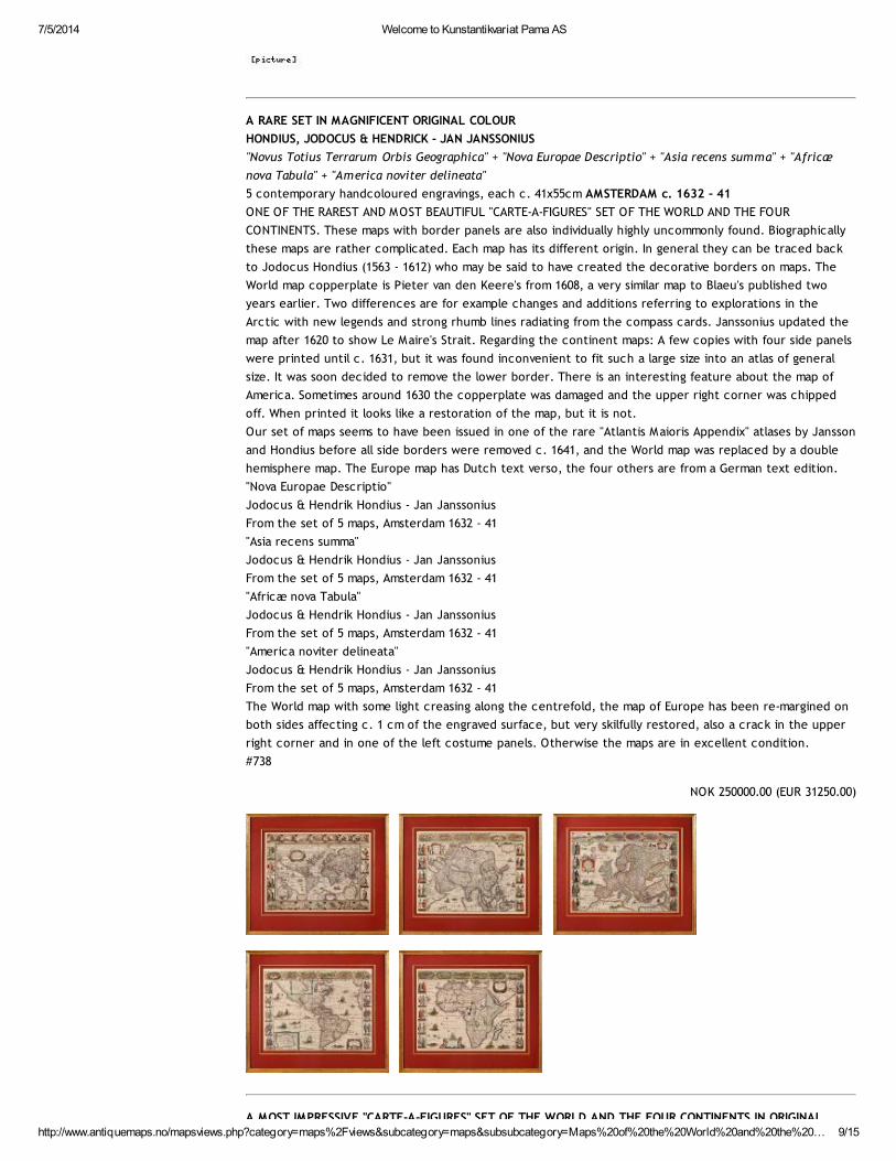
A RARE SET IN MAGNIFICENT ORIGINAL COLOUR
HONDIUS, JODOCUS & HENDRICK - JAN JANSSONIUS
"Novus Totius Terrarum Orbis Geographica" + "Nova Europae Descriptio" + "Asia recens summa" + "Africæ
nova Tabula" + "America noviter delineata"
5 contemporary handcoloured engravings, each c. 41x55cm AMSTERDAM c. 1632 - 41
ONE OF THE RAREST AND MOST BEAUTIFUL "CARTE-A-FIGURES" SET OF THE WORLD AND THE FOUR
CONTINENTS. These maps with border panels are also individually highly uncommonly found. Biographically
these maps are rather complicated. Each map has its different origin. In general they can be traced back
to Jodocus Hondius (1563 - 1612) who may be said to have created the decorative borders on maps. The
World map copperplate is Pieter van den Keere's from 1608, a very similar map to Blaeu's published two
years earlier. Two differences are for example changes and additions referring to explorations in the
Arctic with new legends and strong rhumb lines radiating from the compass cards. Janssonius updated the
map after 1620 to show Le Maire's Strait. Regarding the continent maps: A few copies with four side panels
were printed until c. 1631, but it was found inconvenient to fit such a large size into an atlas of general
size. It was soon decided to remove the lower border. There is an interesting feature about the map of
America. Sometimes around 1630 the copperplate was damaged and the upper right corner was chipped
off. When printed it looks like a restoration of the map, but it is not.
Our set of maps seems to have been issued in one of the rare "Atlantis Maioris Appendix" atlases by Jansson
and Hondius before all side borders were removed c. 1641, and the World map was replaced by a double
hemisphere map. The Europe map has Dutch text verso, the four others are from a German text edition.
"Nova Europae Descriptio"
Jodocus & Hendrik Hondius - Jan Janssonius
From the set of 5 maps, Amsterdam 1632 - 41
"Asia recens summa"
Jodocus & Hendrik Hondius - Jan Janssonius
From the set of 5 maps, Amsterdam 1632 - 41
"Africæ nova Tabula"
Jodocus & Hendrik Hondius - Jan Janssonius
From the set of 5 maps, Amsterdam 1632 - 41
"America noviter delineata"
Jodocus & Hendrik Hondius - Jan Janssonius
From the set of 5 maps, Amsterdam 1632 - 41
The World map with some light creasing along the centrefold, the map of Europe has been re-margined on
both sides affecting c. 1 cm of the engraved surface, but very skilfully restored, also a crack in the upper
right corner and in one of the left costume panels. Otherwise the maps are in excellent condition.
#738
NOK 250000.00 (EUR 31250.00)
A MOST IMPRESSIVE "CARTE-A-FIGURES" SET OF THE WORLD AND THE FOUR CONTINENTS IN ORIGINAL
7/5/2014 Welcome to Kunstantikvariat Pama AS
http://www.antiquemaps.no/mapsviews.php?category=maps%2Fviews&subcategory=maps&subsubcategory=Maps%20of%20the%20World%20and%20the%2… 10/15
A MOST IMPRESSIVE "CARTE-A-FIGURES" SET OF THE WORLD AND THE FOUR CONTINENTS IN ORIGINAL
COLOUR.
JODOCUS & HENDRICK HONDIUS - JAN JANSSONIUS
"Novus Totius Terrarum Orbis Geographica" + "Nova Europae Descriptio" + "Asia recens summa" + "Africæ
nova Tabula" + "America noviter delineata"
5 contemporary hand-coloured engravings, each c. 41x55cm AMSTERDAM C. 1632 - 41
Biographically these maps are rather complicated as each map has its own origin. In general we can trace
them back to Jodocus Hondius (1563 - 1612) who may be said to have created the decorative borders on
maps. The World map copperplate is Pieter van den Keere's from 1608, a very similar map to Blaeu's
published two years earlier. Two differences are changes and additions referring to explorations in the
Arctic with new legends and lines radiating from the compass cards. Janssonius updated the map after 1620
to show Le Maire's Strait. Regarding the continent maps: A few copies with four side panels were printed
until c. 1631, but it was found inconvenient to fit such a large size map into an atlas of general size. The
publisher soon decided to remove the lower border. There is an interesting feature in the map of America.
Sometimes around 1630 the copperplate was damaged and the upper right corner was chipped off. When
printed it looks like a restoration of the paper but it is printed like this.
Our set of maps is probably issued in one of the rare "Atlantis Maioris Appendix" atlases by Jansson and
Hondius before all side borders were removed c. 1641, and the World map was replaced by a double
hemisphere map, see next entry. The Europe map has Dutch text verso, the four others are from a German
text edition.
The World map with some light creasing along the centrefold, the map of Europe has skillfully been re-
margined on both sides affecting c. 1 cm of the engraved surface. There is a crack in the upper right
corner and in one of the left costume panels. Otherwise the maps are in excellent condition.
"Nova Europae Descriptio" Jodocus & Hendrik Hondius - Jan Janssonius From the set of 5 maps, Amsterdam
1632 - 41 "Asia recens summa" Jodocus & Hendrik Hondius - Jan Janssonius From the set of 5 maps,
Amsterdam 1632 - 41 "Africæ nova Tabula" Jodocus & Hendrik Hondius - Jan Janssonius From the set of 5
maps, Amsterdam 1632 - 41 "America noviter delineata" Jodocus & Hendrik Hondius - Jan Janssonius From
the set of 5 maps, Amsterdam 1632 - 41
#1689
NOK 250000.00 (EUR 33300.00)
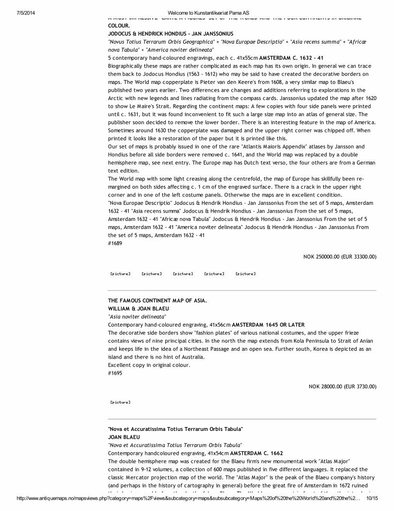
THE FAMOUS CONTINENT MAP OF ASIA.
WILLIAM & JOAN BLAEU
"Asia noviter delineata"
Contemporary hand-coloured engraving, 41x56cm AMSTERDAM 1645 OR LATER
The decorative side borders show "fashion plates" of various national costumes, and the upper frieze
contains views of nine principal cities. In the north the map extends from Kola Peninsula to Strait of Anian
and keeps life in the idea of a Northeast Passage and an open sea. Further south, Korea is depicted as an
island and there is no hint of Australia.
Excellent copy in original colour.
#1695
NOK 28000.00 (EUR 3730.00)
"Nova et Accuratissima Totius Terrarum Orbis Tabula"
JOAN BLAEU
"Nova et Accuratissima Totius Terrarum Orbis Tabula"
Contemporary handcoloured engraving, 41x54cm AMSTERDAM C. 1662
The double hemisphere map was created for the Blaeu firm's new monumental work "Atlas Major"
contained in 9-12 volumes, a collection of 600 maps published in five different languages. It replaced the
classic Mercator projection map of the world. The "Atlas Major" is the peak of the Blaeu company's history
(and perhaps in the history of cartography in general) before the great fire of Amsterdam in 1672 ruined
their business and before the death of Joan Blaeu. The World map was put in front of the atlas introducing
7/5/2014 Welcome to Kunstantikvariat Pama AS
http://www.antiquemaps.no/mapsviews.php?category=maps%2Fviews&subcategory=maps&subsubcategory=Maps%20of%20the%20World%20and%20the%2… 11/15
their business and before the death of Joan Blaeu. The World map was put in front of the atlas introducing
the section of Scandinavia, The Arctic, and Russia.The map is sumptuously decorated. Outside the twin
hemispheres at the top are celestial figures seated among clouds and below are representations of the
four seasons. Galileo overlooks the western hemisphere and the teacher of Joan Blaeu's father, Tycho
Brahe is depicted on the right. Cartographically California is still shown as an island and the west coast of
Australia is well depicted, due to the close relationship between Blaeu and "Veerendige Oost-Indische
Compagnie" (VOC).
(Ref: R. Shirley "The Mapping of the World" no. 428, "Old" Koeman Bl.60A "The Spanish Blaeu")
#1694
NOK 180000.00 (EUR 24000.00)
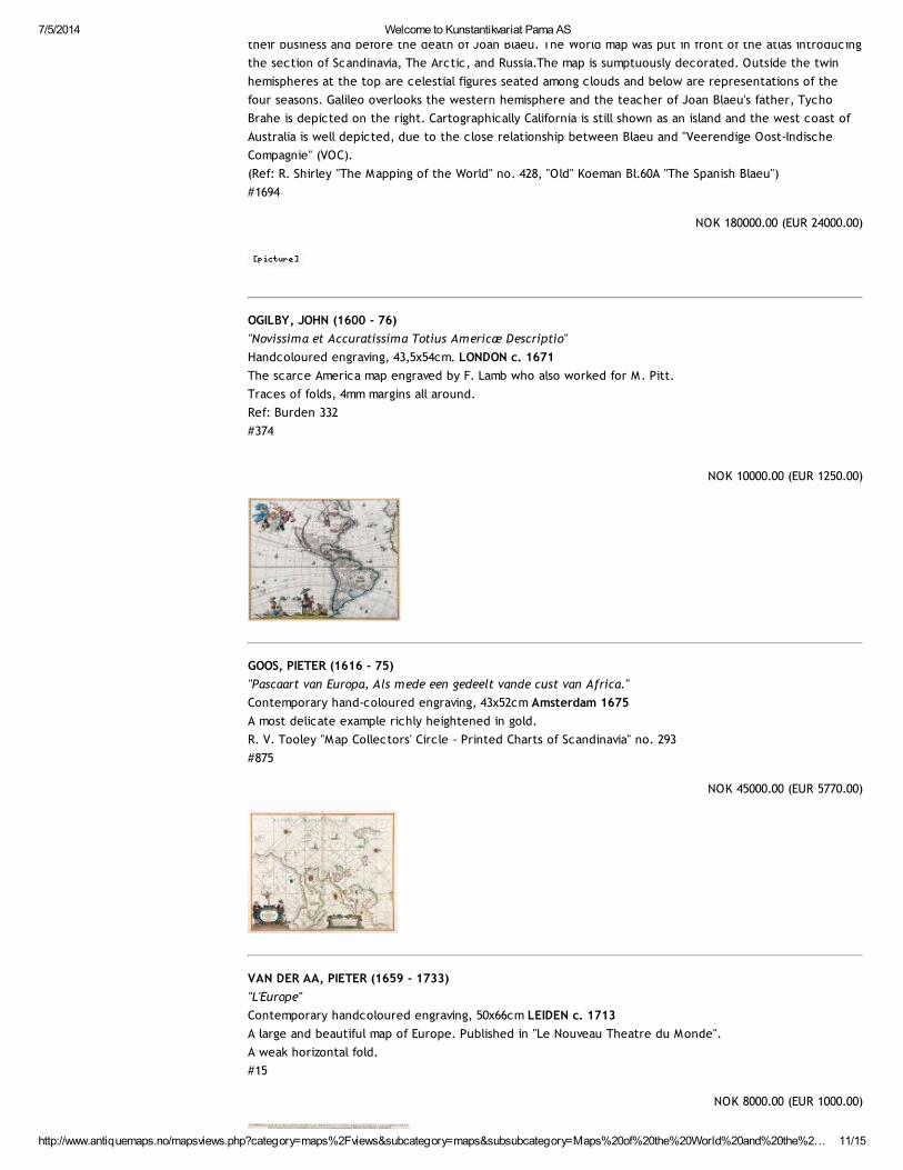
OGILBY, JOHN (1600 - 76)
"Novissima et Accuratissima Totius Americæ Descriptio"
Handcoloured engraving, 43,5x54cm. LONDON c. 1671
The scarce America map engraved by F. Lamb who also worked for M. Pitt.
Traces of folds, 4mm margins all around.
Ref: Burden 332
#374
NOK 10000.00 (EUR 1250.00)
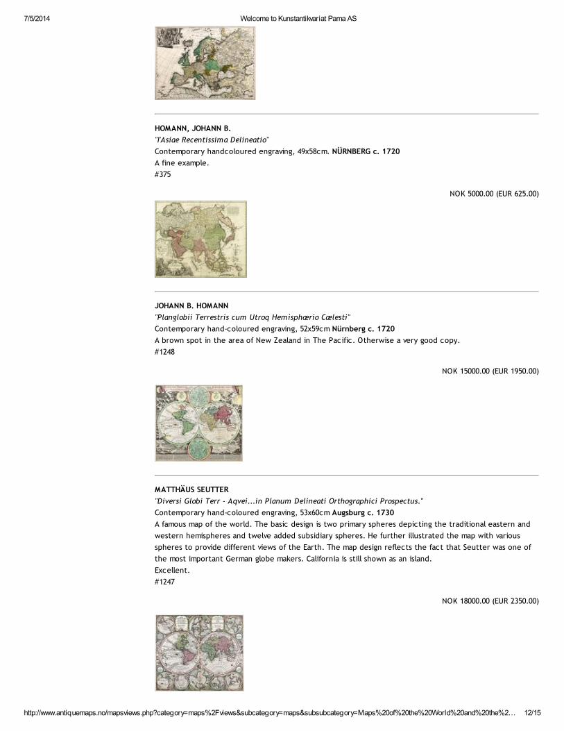
GOOS, PIETER (1616 - 75)
"Pascaart van Europa, Als mede een gedeelt vande cust van Africa."
Contemporary hand-coloured engraving, 43x52cm Amsterdam 1675
A most delicate example richly heightened in gold.
R. V. Tooley "Map Collectors' Circle - Printed Charts of Scandinavia" no. 293
#875
NOK 45000.00 (EUR 5770.00)
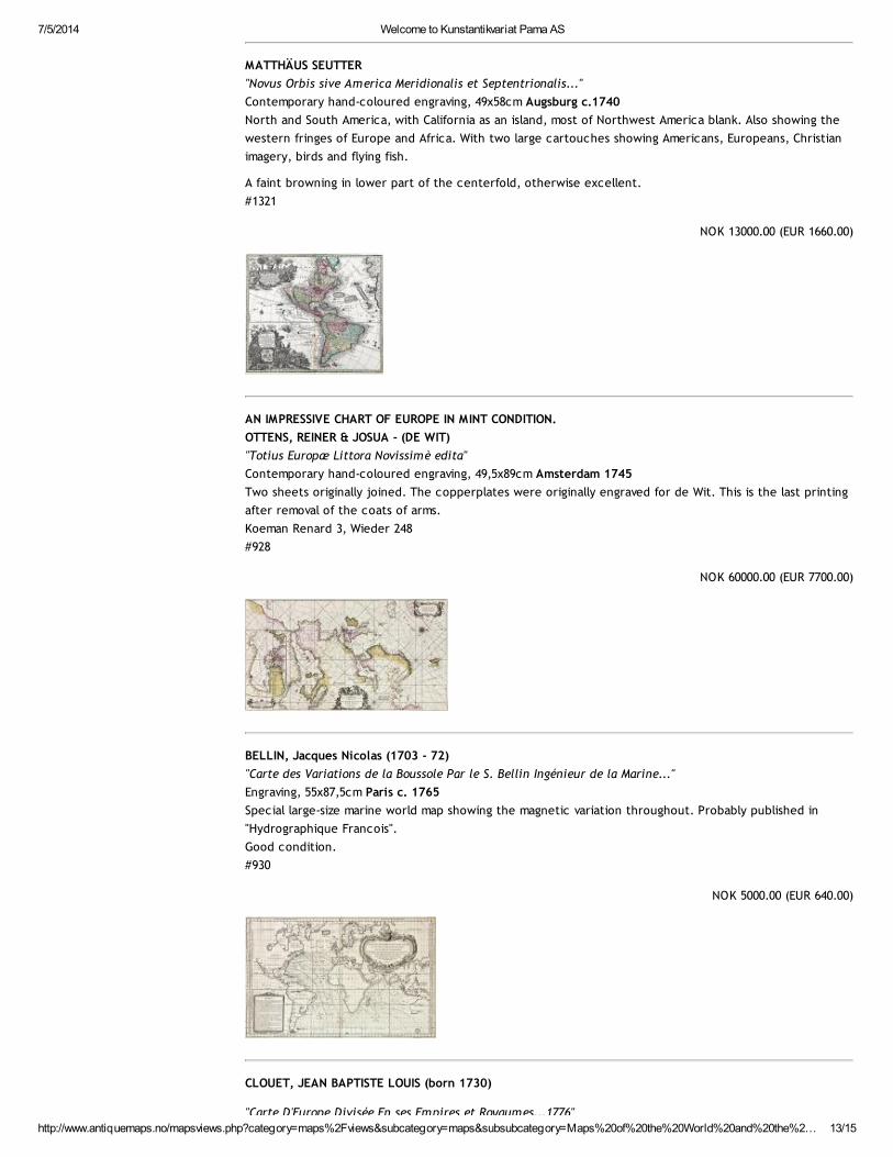
VAN DER AA, PIETER (1659 - 1733)
"L'Europe"
Contemporary handcoloured engraving, 50x66cm LEIDEN c. 1713
A large and beautiful map of Europe. Published in "Le Nouveau Theatre du Monde".
A weak horizontal fold.
#15
NOK 8000.00 (EUR 1000.00)
7/5/2014 Welcome to Kunstantikvariat Pama AS
http://www.antiquemaps.no/mapsviews.php?category=maps%2Fviews&subcategory=maps&subsubcategory=Maps%20of%20the%20World%20and%20the%2… 12/15
HOMANN, JOHANN B.
"I'Asiae Recentissima Delineatio"
Contemporary handcoloured engraving, 49x58cm. NÜRNBERG c. 1720
A fine example.
#375
NOK 5000.00 (EUR 625.00)
JOHANN B. HOMANN
"Planglobii Terrestris cum Utroq Hemisphærio Cælesti"
Contemporary hand-coloured engraving, 52x59cm Nürnberg c. 1720
A brown spot in the area of New Zealand in The Pacific. Otherwise a very good copy.
#1248
NOK 15000.00 (EUR 1950.00)
MATTHÄUS SEUTTER
"Diversi Globi Terr - Aqvei...in Planum Delineati Orthographici Prospectus."
Contemporary hand-coloured engraving, 53x60cm Augsburg c. 1730
A famous map of the world. The basic design is two primary spheres depicting the traditional eastern and
western hemispheres and twelve added subsidiary spheres. He further illustrated the map with various
spheres to provide different views of the Earth. The map design reflects the fact that Seutter was one of
the most important German globe makers. California is still shown as an island.
Excellent.
#1247
NOK 18000.00 (EUR 2350.00)
7/5/2014 Welcome to Kunstantikvariat Pama AS
http://www.antiquemaps.no/mapsviews.php?category=maps%2Fviews&subcategory=maps&subsubcategory=Maps%20of%20the%20World%20and%20the%2… 13/15
MATTHÄUS SEUTTER
"Novus Orbis sive America Meridionalis et Septentrionalis..."
Contemporary hand-coloured engraving, 49x58cm Augsburg c.1740
North and South America, with California as an island, most of Northwest America blank. Also showing the
western fringes of Europe and Africa. With two large cartouches showing Americans, Europeans, Christian
imagery, birds and flying fish.
A faint browning in lower part of the centerfold, otherwise excellent.
#1321
NOK 13000.00 (EUR 1660.00)
AN IMPRESSIVE CHART OF EUROPE IN MINT CONDITION.
OTTENS, REINER & JOSUA - (DE WIT)
"Totius Europæ Littora Novissimè edita"
Contemporary hand-coloured engraving, 49,5x89cm Amsterdam 1745
Two sheets originally joined. The copperplates were originally engraved for de Wit. This is the last printing
after removal of the coats of arms.
Koeman Renard 3, Wieder 248
#928
NOK 60000.00 (EUR 7700.00)
BELLIN, Jacques Nicolas (1703 - 72)
"Carte des Variations de la Boussole Par le S. Bellin Ingénieur de la Marine..."
Engraving, 55x87,5cm Paris c. 1765
Special large-size marine world map showing the magnetic variation throughout. Probably published in
"Hydrographique Francois".
Good condition.
#930
NOK 5000.00 (EUR 640.00)
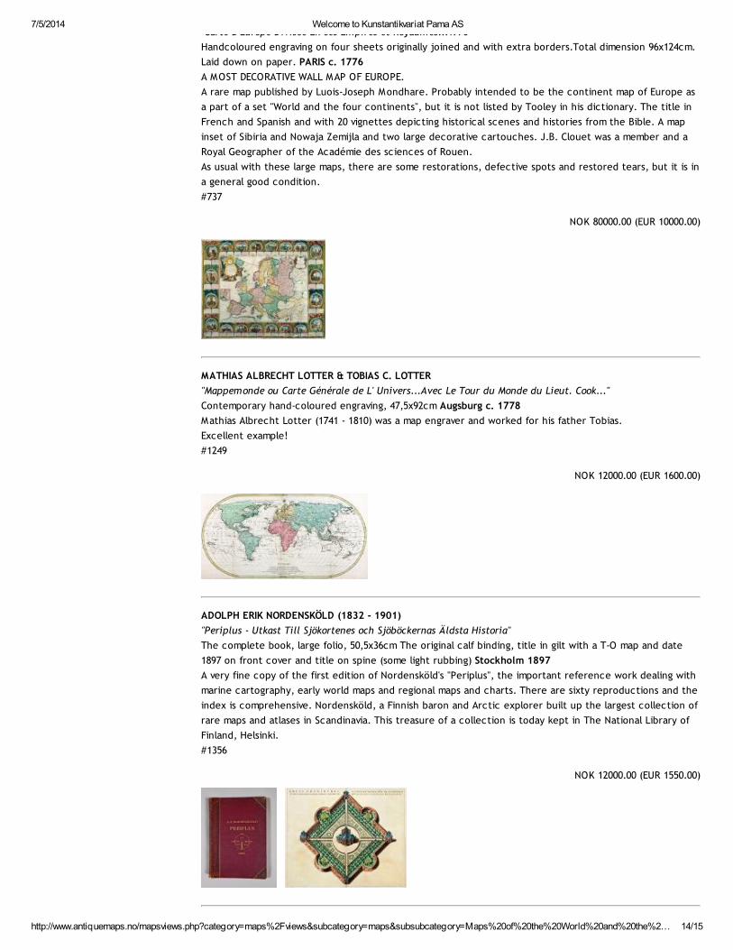
CLOUET, JEAN BAPTISTE LOUIS (born 1730)
"Carte D'Europe Divisée En ses Empires et Royaumes...1776"
7/5/2014 Welcome to Kunstantikvariat Pama AS
http://www.antiquemaps.no/mapsviews.php?category=maps%2Fviews&subcategory=maps&subsubcategory=Maps%20of%20the%20World%20and%20the%2… 14/15
"Carte D'Europe Divisée En ses Empires et Royaumes...1776"
Handcoloured engraving on four sheets originally joined and with extra borders.Total dimension 96x124cm.
Laid down on paper. PARIS c. 1776
A MOST DECORATIVE WALL MAP OF EUROPE.
A rare map published by Luois-Joseph Mondhare. Probably intended to be the continent map of Europe as
a part of a set "World and the four continents", but it is not listed by Tooley in his dictionary. The title in
French and Spanish and with 20 vignettes depicting historical scenes and histories from the Bible. A map
inset of Sibiria and Nowaja Zemijla and two large decorative cartouches. J.B. Clouet was a member and a
Royal Geographer of the Académie des sciences of Rouen.
As usual with these large maps, there are some restorations, defective spots and restored tears, but it is in
a general good condition.
#737
NOK 80000.00 (EUR 10000.00)
MATHIAS ALBRECHT LOTTER & TOBIAS C. LOTTER
"Mappemonde ou Carte Générale de L' Univers...Avec Le Tour du Monde du Lieut. Cook..."
Contemporary hand-coloured engraving, 47,5x92cm Augsburg c. 1778
Mathias Albrecht Lotter (1741 - 1810) was a map engraver and worked for his father Tobias.
Excellent example!
#1249
NOK 12000.00 (EUR 1600.00)
ADOLPH ERIK NORDENSKÖLD (1832 - 1901)
"Periplus - Utkast Till Sjökortenes och Sjöböckernas Äldsta Historia"
The complete book, large folio, 50,5x36cm The original calf binding, title in gilt with a T-O map and date
1897 on front cover and title on spine (some light rubbing) Stockholm 1897
A very fine copy of the first edition of Nordensköld's "Periplus", the important reference work dealing with
marine cartography, early world maps and regional maps and charts. There are sixty reproductions and the
index is comprehensive. Nordensköld, a Finnish baron and Arctic explorer built up the largest collection of
rare maps and atlases in Scandinavia. This treasure of a collection is today kept in The National Library of
Finland, Helsinki.
#1356
NOK 12000.00 (EUR 1550.00)
7/5/2014 Welcome to Kunstantikvariat Pama AS
http://www.antiquemaps.no/mapsviews.php?category=maps%2Fviews&subcategory=maps&subsubcategory=Maps%20of%20the%20World%20and%20the%2… 15/15
web design & hosting by Rockingstone