Embed Size (px)
Citation preview
SCA Proceedings, Volume 30 (2016) Boyd, p. 100
LA CUNA DE AZTLAN: THE CRADLE OF THE AZTEC CIVILIZATION IN THE AMERICAS
MICHAEL E. BOYD
Alfredo Figueroa lives in Blythe. His daughter Patricia Robles lives in Palm Desert. Alfredo is Tribal Cultural Monitor for the Chemehuevi Tribe, and researcher of the creation story as described by written/glyphic and oral histories of the Mexica and Uto-Aztecan peoples. According to Sr. Figueroa's research, as described in his book, "Ancient Footprints of the Colorado River," "Aztlán is commonly referred to as the place of origin for the Aztec/Mexica." According to Figueroa, "The place of origin of the Mexica on the Colorado River was where the vanished island of Aztlán was located in a lake called Lake Mexico."
This article proposes four key concepts concerning the identification of Aztlán:
1. The origin of the Mexica/Aztec along the lower Colorado River.
2. The location of Aztlán, the origin site.
3. The documentation of facts according to the pre-Columbian codices.
4. The existence of glyphic writing utilized by the ancient peoples of the “Americas.”
These key facts, when taken together, should help defeat unfortunate stereotypes and introduce new thinking to the audience.
BACKGROUND
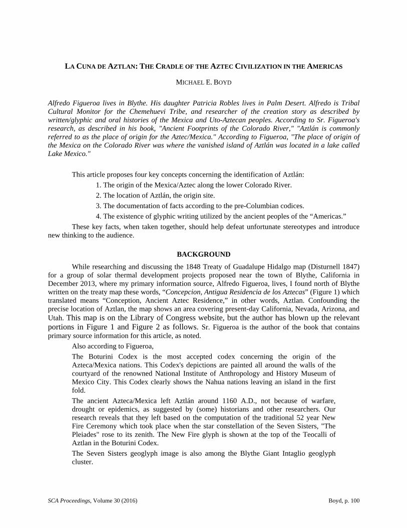
While researching and discussing the 1848 Treaty of Guadalupe Hidalgo map (Disturnell 1847) for a group of solar thermal development projects proposed near the town of Blythe, California in December 2013, where my primary information source, Alfredo Figueroa, lives, I found north of Blythe written on the treaty map these words, “Concepcion, Antigua Residencia de los Aztecas” (Figure 1) which translated means “Conception, Ancient Aztec Residence,” in other words, Aztlan. Confounding the precise location of Aztlan, the map shows an area covering present-day California, Nevada, Arizona, and Utah. This map is on the Library of Congress website, but the author has blown up the relevant portions in Figure 1 and Figure 2 as follows. Sr. Figueroa is the author of the book that contains primary source information for this article, as noted.
Also according to Figueroa,
The Boturini Codex is the most accepted codex concerning the origin of the Azteca/Mexica nations. This Codex's depictions are painted all around the walls of the courtyard of the renowned National Institute of Anthropology and History Museum of Mexico City. This Codex clearly shows the Nahua nations leaving an island in the first fold.
The ancient Azteca/Mexica left Aztlán around 1160 A.D., not because of warfare, drought or epidemics, as suggested by (some) historians and other researchers. Our research reveals that they left based on the computation of the traditional 52 year New Fire Ceremony which took place when the star constellation of the Seven Sisters, "The Pleiades" rose to its zenith. The New Fire glyph is shown at the top of the Teocalli of Aztlan in the Boturini Codex.
The Seven Sisters geoglyph image is also among the Blythe Giant Intaglio geoglyph cluster.
SCA Proceedings, Volume 30 (2016) Boyd, p. 101
Figure 1. 1848 Treaty of Guadalupe Hidalgo map (Disturnell 1847).
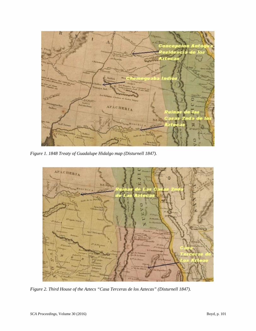
Figure 2. Third House of the Aztecs “Casa Terceras de los Aztecas” (Disturnell 1847).

SCA Proceedings, Volume 30 (2016) Boyd, p. 102
Guided by a prophecy attributed to “Huitzilopochli”, the Nahua followed the same migration path used by the herons and other migrating birds on their annual flight from the lakes of central Canada down the Colorado and south to Canada. Most historians agree that all the Nahua families left from the same area at one time or another, each taking a different route (Carpanta, Boturini codices). [Figueroa, personal communication 2014].
As described by Figueroa in Ancient Footprints of the Colorado River,
In 1804, the eminent German cartographer and historian, Alexander von Humboldt drew a map of what was at that time called New Spain, which included present day Mexico and the Southwestern United States. Von Humboldt never visited the Lower Colorado River Valleys, so his informants must have given him information and copied some earlier maps. The information of some of the sites mentioned is relatively close to the actual localities here in the Lower Colorado River Valleys…. The Humboldt map was the official map used in the signing of the Treaty of Guadalupe Hidalgo by the United States and Mexico on February 2, 1848. Mexico lost more than half their original territory, which included Aztlán [Figueroa 2002].
Southeast of that location on the map, in what is present-day southeast Arizona, it lists “Ruinas de las Casas 2nda de los Aztecas” which translated means the “Ruins of the Second House of the Aztecs.” The National Park Service has designated the site as the Casa Grande ruins. Interestingly, the treaty map shows a pyramid at this location. The National Monument consists of the ruins of multiple structures surrounded by a compound wall constructed by the ancient people of the Hohokam period, who farmed the Gila Valley in the early thirteenth century. “Archeologists have discovered evidence that the ancient Sonoran Desert people who built the Casa Grande also developed wide-scale irrigation farming and extensive trade connections which lasted over a thousand years until about 1450 C.E.” (National Park Service ca. 2015)
In Figure 2, it is shown that approximately southeast the same distance a Third House of the Aztecs is located at the site listed as “Casa Terceras de los Aztecas” (“Third House of the Aztecs”). There are three pyramids shown on the treaty map for this site. This site is already recognized by the United Nations as a World Heritage Site Archaeological Zone of Paquimé, Casas Grandes. The archaeological zone of Paquimé is located in the Municipality of Casas Grandes, Chihuahua, Mexico. The UNESCO World Heritage Centre lists the site as follows:
The archaeological zone of Paquimé is located in the Municipality of Casas Grandes, Chihuahua, Mexico. It is located at the foot of the Sierra Madre Occidental range near the headwaters of the Casas Grandes River. It is estimated to contain the remains of some 2,000 rooms in clusters of living rooms, workshops and stores, with patios [UNESCO 2015].
After being burned in 1340 C.E., Casas Grandes was rebuilt as multistory apartment buildings. Casas Grandes consisted of approximately 2,000 adjoining rooms built of adobe, I-shaped Mesoamerican ballcourts, stone-faced platforms, effigy mounds, and a market area. About 350 other, smaller settlement sites have been identified in the Casas Grandes area some as far as 70 km (43 mi.) away. Some archaeologists believe that the area directly controlled by Casas Grandes was relatively small, extending out about 30 km (18 miles) from the city. “The population may have been about 2,500 in Casas Grandes with perhaps 10,000 people living within its area of control” (UNESCO 2015)
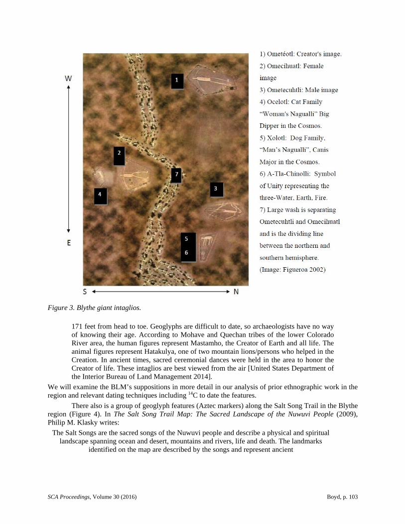
The Blythe giant intaglios (Figure 3) are “about 15 miles north of Blythe, California, on U.S. Route 95” according to the website of the Bureau of Land Management (BLM), which describes these features as “prehistoric earth figures or geoglyphs”:
There are a total of six distinct figures in three locations, including a human figure at each location and an animal figure at two locations. The largest human figure measures
SCA Proceedings, Volume 30 (2016) Boyd, p. 103
Figure 3. Blythe giant intaglios.
171 feet from head to toe. Geoglyphs are difficult to date, so archaeologists have no way of knowing their age. According to Mohave and Quechan tribes of the lower Colorado River area, the human figures represent Mastamho, the Creator of Earth and all life. The animal figures represent Hatakulya, one of two mountain lions/persons who helped in the Creation. In ancient times, sacred ceremonial dances were held in the area to honor the Creator of life. These intaglios are best viewed from the air [United States Department of the Interior Bureau of Land Management 2014].
We will examine the BLM’s suppositions in more detail in our analysis of prior ethnographic work in the region and relevant dating techniques including 14C to date the features.
There also is a group of geoglyph features (Aztec markers) along the Salt Song Trail in the Blythe region (Figure 4). In The Salt Song Trail Map: The Sacred Landscape of the Nuwuvi People (2009), Philip M. Klasky writes:
The Salt Songs are the sacred songs of the Nuwuvi people and describe a physical and spiritual landscape spanning ocean and desert, mountains and rivers, life and death. The landmarks
identified on the map are described by the songs and represent ancient

SCA Proceedings, Volume 30 (2016) Boyd, p. 104
Figure 4. Salt Song Trail, Blythe region sacred sites (image and text provided by Figueroa).
villages, gathering sites for salt and medicinal herbs, trading routes, historic events, sacred areas, and cultural landscapes. At memorial ceremonies, Salt Song singers “throwing the gourd” are accompanied by dancers as they perform the 142 song cycle from sunset to sunrise to assist the deceased in their sacred journey. The Salt Songs begin their journey at Avi Nava/Ting-ai-ay (Rock House), a sacred cave at the confluence of the Bill Williams and Colorado Rivers. The songs travel north along the Colorado River to the Kaibab and Colorado Plateau, into Southern Utah, and then west to the great mountain Nuva Kaiv (Mt. Charleston) -- the place of origination of the Nuwuvi people -- and then further west to rise above the Pacific Ocean before arcing back east through the Mojave desert to their origin at Avi Nava [Klasky 2009:1, 3]
The major east/west trail can be followed from the Blythe Giant Intaglios to El Tosco group geoglyphs. There are over 10 large geoglyphs in this group within a quarter of a mile.
I asked Alfredo where the Hohokam disappear to. Alfredo wrote:
you already have copies of the Treaty of Guadalupe map where it clearly shows Casa Grande, Arizona as the second stop of the Aztecas from the Colorado River. The third

SCA Proceedings, Volume 30 (2016) Boyd, p. 105
stop was at Casas Grandes, Chihuahua, Mexico. Here they have already crossed the United States/Mexican border which is the largest wall in the world.…
Alexander Van [sic] Humboldt knew all this information in 1804 when he first drew the map. Only today, the so-called experts in history don't know where the Hohokam went to. They just disappeared into thin air. After 166 years, since 1848, they still cannot figure it out [Figueroa, personal communication 2014]
Hohokam culture is prehistoric North American Indians who lived approximately from A.D. 200 to 1400 in the semiarid region of present-day central and southern Arizona, largely along the Gila and Salt Rivers. The term Hohokam is said to be Pima for “those who have vanished.”
Added to these facts is the following information that I am sending you. Approximately 15 miles northwest of Casa Grande Ruins National Monument is the town of Sacaton, one of the oldest communities of the Pima/Tohono O'Odhan. Their main capital was Caborca, Sonora, 90 miles south of the border. My father's mother is buried there. She was 96 years old and was Yaqui-Opata and Tohono O'Odhan…. Now back to Sacaton, the Pima all came from the Colorado River and the Hohokams did too. The Hohokam left the Gila/Salt River Valleys. They went south and some stayed in Zacatecas, Mexico. Zacatecas is a state and also its capitol. It is on one of the migration trails south that is in the codices. Sacaton or house, ton refers to big. In other words, Sacaton means the place/house of the big grass. That is why they call the tribe in Mexico, Zacatecos, because they came from Sacaton in Arizona. Likewise if I call you Big Mike in Spanish/Nahuatl I would call you Miketon….. Near Sacaton, Arizona is the further east giant geoglyph. It is called Haak Vaak, a humanoid image that is 35 meters long and a small figure pointing northwest towards the Topock Maze 10 miles southeast of Needles, CA. Here the giant is taking a half-human to the underworld. One of the best informative books of the geoglyphs is Boma Johnson’s [1985] [Figueroa, personal communication 2014).
When I asked Alfredo about the origins of the Aztecs, he explained there was no beginning, and no end, there was no Eurocentric view in the Aztec universe, just the “continuum.” In response, he writes, the
crucial mathematical breakdown of cosmic measurements of time has been totally rejected or left in obscurity by the European invaders and by modern-day astronomers. Recently astronomers have begun to accept the fact that there is not a beginning or ending in the universe giving acknowledgement to the Maya/Mexica cosmic tradition archetype that refers to the Milky Way and in Nahuatl, it is called Mixcoatl that relates to “cloud of serpents” that has no ending nor beginning. It is continuous [Figueroa, personal communication 2014].
He goes on to write, “Zero, ‘0’ represents the Creator, the one who has no name and has all the names. It is image is in the cosmos in the Black Hole, the center of the spiral of the Milky Way” (Figueroa, personal communication 2014).
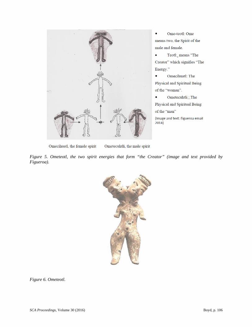
Ometeotl, the Creator, is formed by the female and male spirits as shown in Figure 5. In Figure 6, this clay figurine was found at Tlatilco near Mexico City. According to Figueroa, “It represents physical and spiritual being within a person that represents life and death, exactly what the physical/spiritual representation of the Blythe Female Intaglio is.” He explained that to understand what Klasky described as one place, “physical and spiritual landscape spanning ocean and desert, mountains and rivers, life and death” (Klasky 2009), you have to treat this four-state region as Tamoanchan, Where Cosmos
SCA Proceedings, Volume 30 (2016) Boyd, p. 106
Figure 5. Ometeotl, the two spirit energies that form “the Creator” (image and text provided by Figueroa).
Figure 6. Ometeotl.
SCA Proceedings, Volume 30 (2016) Boyd, p. 107
Meets Earth. Then he will explain for us the Cicimitl, Where 13Magnetic North Meets True North, followed by its relationship to Ophiuchus, the 13th Constellation, the Similarities of Quetzalcoatl and Ophiuchus, and how that Aztec Sunstone Calendar Tonal-Machiotl relates to the 104 Thousand Years of Recorded History. Alfredo writes:
The Blythe Giant Intaglios geoglyph images are the cosmic archetype (duality on earth) of the Creator's images in the cosmos. They represent the Creator's human images where time first began on earth. The Spring Equinox event is the beginning of time which is when the first rays of light shine between the two peaks in the Moon Mountains located directly east of the Intaglios on the Colorado River Indian Tribes Reservation. The first sun rays shine on the Big Maria Mountains that has the head of the image of Huitzilopochtli. The Island of Aztlán was directly below the two peaks and today is known as Moon Mountain Ranch…. The Creation Story has been told through generations of the oral history by the Indigenous People. It is confirmed with the 5 suns of the Aztec Sunstone calendar and the following images and information that are in the surrounding Colorado River Valleys…. Although the word religion is not used, it does not retract [sic] from the beliefs of the Indigenous People based on the oral history handed down to the generations. The oral history is confirmed through the Mexica codices. There is a Creator as demonstrated at the Blythe Giant Intaglios of Ometeotl…. The Treaty of Guadalupe map of February 2, 1848, is one of the most important documents of the United States that reveals the evidentiary proof that shows the point of conception (where creation began) and ancient residence (homeland) of the Aztec People on the Colorado River. Below the conception point you will see the Chemeguaba Indian Tribe Homeland (Today's Chemehuevi) [Figueroa, personal communication 2014].
“The Blythe Giant Intaglios are the prime example of the Creator's image and how the three form one spirit, Ometeotl. In the Intaglios, they are arranged in the form of an arrow which relates to the male, female, and the Creator (the center point of the arrow)” (Figueroa, personal communication 2014).
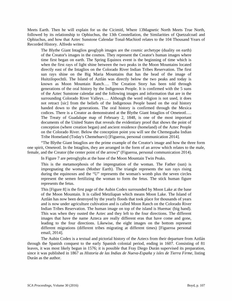
In Figure 7 are petroglyphs at the base of the Moon Mountain Twin Peaks.
This is the metamorphosis of the impregnation of the woman. The Father (sun) is impregnating the woman (Mother Earth). The triangle represents the sun rays rising during the equinoxes and the “U” represents the woman's womb plus the seven circles represent the semen fertilizing the woman to form the fetus. The stick human figure represents the fetus.
This [Figure 8] is the first page of the Aubin Codex surrounded by Moon Lake at the base of the Moon Mountain. It is called Metzliapan which means Moon Lake. The Island of Aztlán has now been destroyed by the yearly floods that took place for thousands of years and is now under agriculture cultivation and is called Moon Ranch on the Colorado River Indian Tribes Reservation. The human image on top of the island is Huemac (big hand). This was when they ousted the Aztec and they left to the four directions. The different images that have the name Azteca are really different eras that have come and gone, leading to the four directions. Likewise, the eight images on the bottom represent different migrations (different tribes migrating at different times) [Figueroa personal email, 2014].
The Aubin Codex is a textual and pictorial history of the Aztecs from their departure from Aztlán through the Spanish conquest to the early Spanish colonial period, ending in 1607. Consisting of 81 leaves, it was most likely begun in 1576; it is possible that Fray Diego Durán supervised its preparation, since it was published in 1867 as Historia de las Indias de Nueva-España y isles de Tierra Firme, listing Durán as the author.
SCA Proceedings, Volume 30 (2016) Boyd, p. 108
Figure 7. Petroglyphs at the base of the Moon Mountain Twin Peaks.
The old Moon Lake is shown as Laguna in Figure 9 and it is at the base of the Moon Mountain on the Colorado River Indian Tribes Reservation and east of the Blythe Giant Intaglios. It is the Island of Metzliapan.
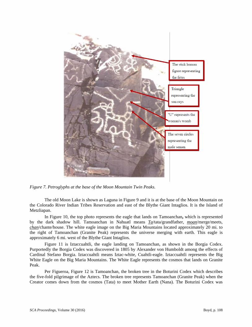
In Figure 10, the top photo represents the eagle that lands on Tamoanchan, which is represented by the dark shadow hill. Tamoanchan in Nahuatl means Ta/tata/grandfather, moan/merge/meets, chan/chante/house. The white eagle image on the Big Maria Mountains located approximately 20 mi. to the right of Tamoanchan (Granite Peak) represents the universe merging with earth. This eagle is approximately 6 mi. west of the Blythe Giant Intaglios.
Figure 11 is Iztaccuahtli, the eagle landing on Tamoanchan, as shown in the Borgia Codex. Purportedly the Borgia Codex was discovered in 1805 by Alexander von Humboldt among the effects of Cardinal Stefano Borgia. Iztaccuahtli means Iztac-white, Cuahtli-eagle. Iztaccuahtli represents the Big White Eagle on the Big Maria Mountains. The White Eagle represents the cosmos that lands on Granite Peak.
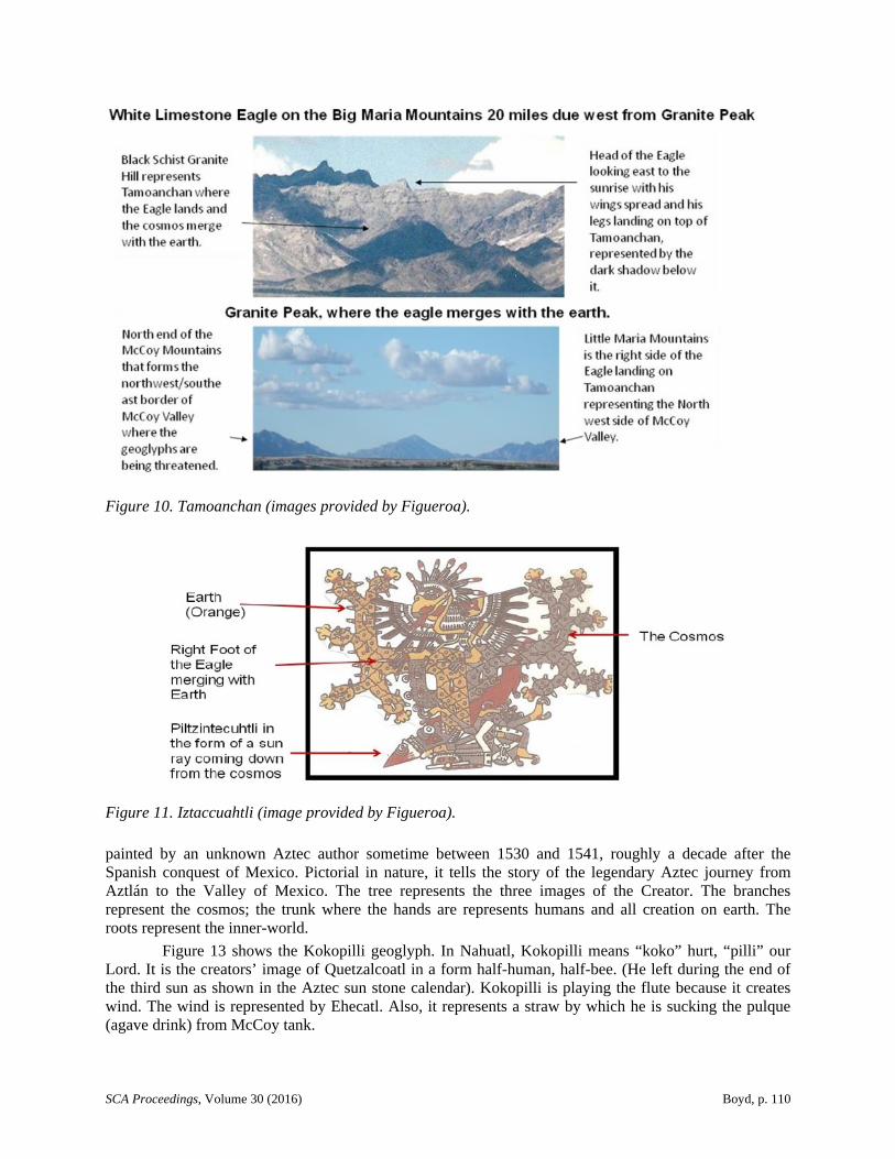
Per Figueroa, Figure 12 is Tamoanchan, the broken tree in the Boturini Codex which describes the five-fold pilgrimage of the Aztecs. The broken tree represents Tamoanchan (Granite Peak) when the Creator comes down from the cosmos (Tata) to meet Mother Earth (Nana). The Boturini Codex was

SCA Proceedings, Volume 30 (2016) Boyd, p. 109
Figure 8. Image from Aubin Codices (Figueroa 2002).
Figure 9. Location of Moon Lake (1881 map of Arizona).
SCA Proceedings, Volume 30 (2016) Boyd, p. 110
Figure 10. Tamoanchan (images provided by Figueroa).
Figure 11. Iztaccuahtli (image provided by Figueroa).
painted by an unknown Aztec author sometime between 1530 and 1541, roughly a decade after the Spanish conquest of Mexico. Pictorial in nature, it tells the story of the legendary Aztec journey from Aztlán to the Valley of Mexico. The tree represents the three images of the Creator. The branches represent the cosmos; the trunk where the hands are represents humans and all creation on earth. The roots represent the inner-world.
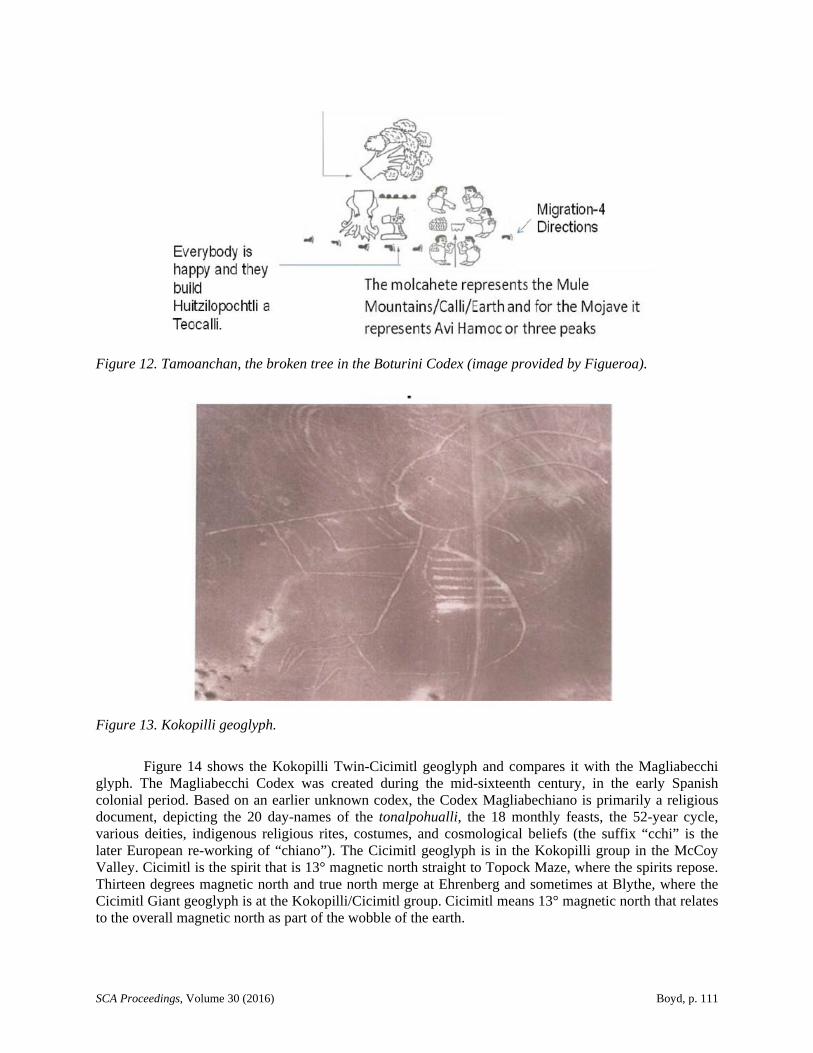
Figure 13 shows the Kokopilli geoglyph. In Nahuatl, Kokopilli means “koko” hurt, “pilli” our Lord. It is the creators’ image of Quetzalcoatl in a form half-human, half-bee. (He left during the end of the third sun as shown in the Aztec sun stone calendar). Kokopilli is playing the flute because it creates wind. The wind is represented by Ehecatl. Also, it represents a straw by which he is sucking the pulque (agave drink) from McCoy tank.
SCA Proceedings, Volume 30 (2016) Boyd, p. 111
Figure 12. Tamoanchan, the broken tree in the Boturini Codex (image provided by Figueroa).
Figure 13. Kokopilli geoglyph.
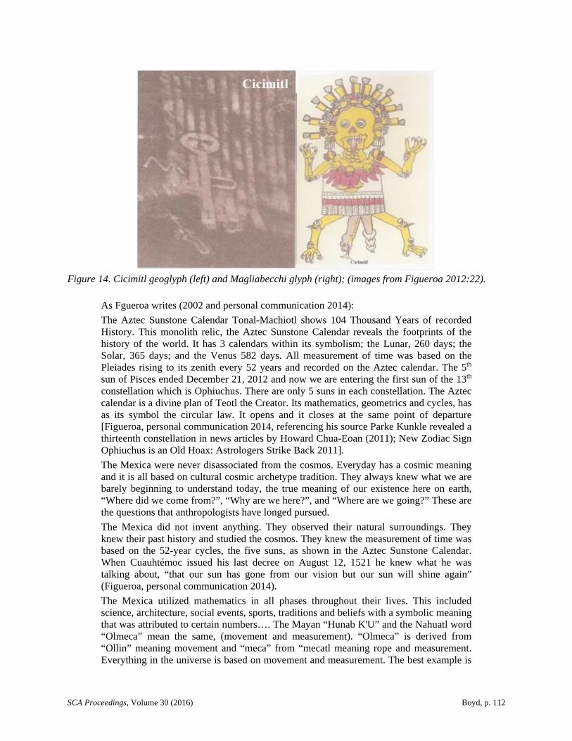
Figure 14 shows the Kokopilli Twin-Cicimitl geoglyph and compares it with the Magliabecchi glyph. The Magliabecchi Codex was created during the mid-sixteenth century, in the early Spanish colonial period. Based on an earlier unknown codex, the Codex Magliabechiano is primarily a religious document, depicting the 20 day-names of the tonalpohualli, the 18 monthly feasts, the 52-year cycle, various deities, indigenous religious rites, costumes, and cosmological beliefs (the suffix “cchi” is the later European re-working of “chiano”). The Cicimitl geoglyph is in the Kokopilli group in the McCoy Valley. Cicimitl is the spirit that is 13° magnetic north straight to Topock Maze, where the spirits repose. Thirteen degrees magnetic north and true north merge at Ehrenberg and sometimes at Blythe, where the Cicimitl Giant geoglyph is at the Kokopilli/Cicimitl group. Cicimitl means 13° magnetic north that relates to the overall magnetic north as part of the wobble of the earth.
SCA Proceedings, Volume 30 (2016) Boyd, p. 112
Figure 14. Cicimitl geoglyph (left) and Magliabecchi glyph (right); (images from Figueroa 2012:22).
As Fgueroa writes (2002 and personal communication 2014):
The Aztec Sunstone Calendar Tonal-Machiotl shows 104 Thousand Years of recorded History. This monolith relic, the Aztec Sunstone Calendar reveals the footprints of the history of the world. It has 3 calendars within its symbolism; the Lunar, 260 days; the Solar, 365 days; and the Venus 582 days. All measurement of time was based on the Pleiades rising to its zenith every 52 years and recorded on the Aztec calendar. The 5th sun of Pisces ended December 21, 2012 and now we are entering the first sun of the 13th constellation which is Ophiuchus. There are only 5 suns in each constellation. The Aztec calendar is a divine plan of Teotl the Creator. Its mathematics, geometrics and cycles, has as its symbol the circular law. It opens and it closes at the same point of departure [Figueroa, personal communication 2014, referencing his source Parke Kunkle revealed a thirteenth constellation in news articles by Howard Chua-Eoan (2011); New Zodiac Sign Ophiuchus is an Old Hoax: Astrologers Strike Back 2011].
The Mexica were never disassociated from the cosmos. Everyday has a cosmic meaning and it is all based on cultural cosmic archetype tradition. They always knew what we are barely beginning to understand today, the true meaning of our existence here on earth, “Where did we come from?”, “Why are we here?”, and “Where are we going?” These are the questions that anthropologists have longed pursued.
The Mexica did not invent anything. They observed their natural surroundings. They knew their past history and studied the cosmos. They knew the measurement of time was based on the 52-year cycles, the five suns, as shown in the Aztec Sunstone Calendar. When Cuauhtémoc issued his last decree on August 12, 1521 he knew what he was talking about, “that our sun has gone from our vision but our sun will shine again” (Figueroa, personal communication 2014).
The Mexica utilized mathematics in all phases throughout their lives. This included science, architecture, social events, sports, traditions and beliefs with a symbolic meaning that was attributed to certain numbers…. The Mayan “Hunab K'U” and the Nahuatl word “Olmeca” mean the same, (movement and measurement). “Olmeca” is derived from “Ollin” meaning movement and “meca” from “mecatl meaning rope and measurement. Everything in the universe is based on movement and measurement. The best example is
SCA Proceedings, Volume 30 (2016) Boyd, p. 113
the Mexica/Mayan Sunstone calendar which represents measurement and movement and symbolizes the universe…. The zero represents the beginning, the end, chaos, and the infinity. Thousands of years before the European invasion, the Indigenous people of Anahuac were fully aware and were guided by the concept of the ‘0’ and the use of the decimal point. That is why the Mexica/Mayan calendar is more precise than the European Gregorian calendar. Furthermore, European math began with the Roman numeral “I” and did not even acknowledge the “0” at all [Figueroa 2002:55, personal communication 2014].
ENVIRONMENTAL SETTING
The Chemehuevi Tribe is part of the Colorado River Indian Tribes (CRIT). The relationship of the Mojave peoples to other tribes along the Colorado River is described as follows:
The Colorado River Indian Tribes include four distinct Tribes - the Mohave, Chemehuevi, Hopi and Navajo. There are currently about 4,277 active Tribal members.
The CRIT Reservation was created in 1865 by the Federal Government for “Indians of the Colorado River and its tributaries,” originally for the Mohave and Chemehuevi, who had inhabited the area for centuries. People of the Hopi and Navajo Tribes were relocated to the reservation in later years.
The reservation stretches along the Colorado River on both the Arizona and California side. It includes almost 300,000 acres of land, with the river serving as the focal point and lifeblood of the area [Colorado River Indian Tribes 2008].
The Mojave Desert is a hot, arid region, with typically less than 10 in. of rain per year. A. L. Kroeber's Handbook of the Indians of California (1925) gives a detailed description of the environmental setting of the Chemehuevi tribe that resides there:
With the Mohave, the third Yuman tribe to be considered, we reach for the first time a people living on a large river. The Colorado is one of the great streams of the continent, voluminous, and far longer than any within the boundaries of California. From the Mohave to its mouth its shores were occupied by a line of Yuman tribes, similar in speech, in habits, in appearance, and in disposition. This enormous Nile, flowing through narrow bottom lands bordered sharply by sandy stretches, high mesa rims, and barren mountains rising on both sides from an utterly arid desert, provides a setting wholly unlike any heretofore encountered. And its civilization is equally distinct.
The country of the Mohave is the valley which bears their name, the uppermost of a number that stretch at intervals to the sea. Above is the great defile known as Eldorado Canyon, visited now and then by Chemehuevi and Walapai, who lived above it on west and east, but unfit for habitation; and beyond comes a bend and the vast gorge that culminates in the Grand Canyon. The river civilization thus comes to a sudden upstream stop with the Mohave.
Their valley lies in what is now three states: California, Nevada, and Arizona. As the channel has flowed in recent years, most of the bottom lands lie on the eastern side; and there the bulk of the settlements were. But the land is so shut in by the high desert and so dependent on the river that it is an inevitable unit. East and west, the left bank and the right, are incidental. The stream course is a furrow that separates Arizona from California, as culturally it divides the Southwest from California; and whoever lived in the trench belonged as much, and as little, to one, area as to the other [Kroeber 1925:726].
Michael J. Moratto’s book, California Archaeology, describes the effect of the arid environmental setting on the lifeways of the Mojave peoples:
SCA Proceedings, Volume 30 (2016) Boyd, p. 114
At higher elevations the creosote bush community gives way to the black bush community, which includes yuccas and agaves, both important food plants. The black bush community is in turn replaced at still higher elevations by the piñon-juniper community. Piñon pine was an important aboriginal food source, but is found only in the higher mountain ranges of the eastern and northern Mojave and in the Sierra Nevada, Transverse, and Peninsular ranges on the western margin of the desert.
Plant communities localized around springs, marshes, and streambeds produce tules, cattail, and various grasses. In the washes of the Colorado Desert are found desert ironwood and palo verde--not found in the Mojave Desert--along with several other varieties of small trees and shrubs common to both deserts. In the Great Basin to the north, the plant communities change: yucca and mesquite are no longer found, sagebrush replaces black bush and to a large extent creosote bush, grasses increase and piñon becomes more common on the mountain slopes.
Throughout the California deserts, large game animals are not plentiful and in most places are quite rare. The major large game animals hunted by Indians were most often mountain sheep, deer, and pronghorn. Jackrabbits and desert cottontail were commonly taken, as were wood rat and various small rodents, lizards, and desert tortoise [Warren 1984:343].
PREHISTORY OVERVIEW
Research on the prehistoric climate of the Mojave desert region shows little climatic change over the last 20,000 years, but when change did occur; the native populations adapted their subsistence strategies accordingly. According to Mark Sutton and his associates,
During the Late Pleistocene (ca. 18,000 to 8000 cal B.C.), conditions in the Mojave Desert were generally cool and wet. During the Early Holocene (ca. 8000 to 6000 cal B.C.), conditions were somewhat cooler and moister than today. The Middle Holocene (ca. 6000 to 3000 cal B.C.) witnessed a much warmer and drier climate than modern times. Finally, the climate became moderately cooler and wetter again during the Late Holocene (ca. 3000 cal B.C. to present), punctuated with periods of drought [Sutton et al. 2006:230-231].
Sutton and his associates discussed the impacts of the Medieval Climate Anomaly [MCA] on the Mojave peoples:
Late Prehistoric Complexes. After about cal A.D. 1100, the environment continued to deteriorate as a result of the MCA, new technologies were introduced, populations appear to have declined, and a number of separate cultural complexes emerged that are believed to represent the prehistoric aspects of known ethnographic groups. Warren (1984:420) noted “strong regional developments” across the Mojave Desert during this time, including Anasazi interests in turquoise mining in the Mojave Trough, Hakatayan influence from the Colorado River, and the Numic Paiute and Shoshone culture that likely spread eastward (the Numic expansion …) from the western Mojave Desert about cal A.D. 1000.
Late Prehistoric occupation sites in the Mojave Desert represent a variety of types, including a few major villages with associated cemeteries, as well as special purpose and seasonal sites (Gardner 2006). Artifact assemblages consist of Desert series projectile point, buffware and brownware ceramics, shell and steatite beads, slate pendants, incised stones, and a variety of milling tools (Warren and Crabtree 1986). Faunal remains typically consist of lagomorphs, deer, rodent, and some reptiles. Obsidian use dropped off significantly, and flaked stone tool manufacture shifted to silicate stone. Our under-
SCA Proceedings, Volume 30 (2016) Boyd, p. 115
standing of the time frame for the Late Prehistoric complexes (ca. cal A.D. 1100 to contact) has remained largely unchanged over the past 20 years Sutton et al. 2006:242].
AN ETHNOGRAPHIC OVERVIEW
Warren describes the confounding effects to any ethnographical analysis due to multiple tribal groups sharing the same area's resources, and their ever-shifting territorial boundaries over time:
The Mojave, Halchidoma, and Quechan were river agriculturalists who were later joined by the Kamia from the Colorado Desert during historic times. The Chemehuevi also moved into the Colorado River Valley and took up agricultural practices, displacing the Halchidoma during the early historic period. Nonagricultural hunter-gatherers included all the remaining groups and some Chemehuevi. The southernmost of the hunter-gatherers--Cahuilla, Serrano, and Kitanemuk--developed sociopolitical and socioeconomic systems that set them apart from the other speakers of Uto-Aztecan languages in the Mojave Desert and apparently linked them with the coastal peoples of California as well as the Colorado River groups [Warren 1984:344].
Part of the oral traditions of the Mohave was their belief of leaving no personal belongings or their bodies behind when they died. They cremated their dead, burning all their belongings in the funeral pyre, and burning their homes, too. Kroeber's Handbook of the Indians of California gives a detailed description of the practices:
The Mohave have the appalling habit of beginning their wailing and singing some hours before an expected death. If the patient possesses unexpected vitality, the singing may go on for two or three days. In certain crucial cases the effect must be adverse; but the probability is that the mourning usually commences only after the sick person has indicated his expectation of dying, and that he is comforted by the unrestrained solicitude and grief of the crowd of his kinsmen and friends. General mourning after death goes on only for a very few hours; unless a death has occurred suddenly, when time must be allowed to assemble the relatives. A trench is scooped out near the house, willow or cottonwood logs piled above it, the body laid on with its head to the south, burning arrow weeds applied, and when the fire has sunk into the pit, sand is pushed over it. There are no cemeteries. The house and shade are immediately set on fire with all their contents. While the pyre is blazing, the shouts and lamentations are at their height, property is thrown into the flames, and people even strip themselves of their garments. All relatives, however remote, attend the cremation and weep; afterwards, only the closest kin cry for a few days, then go about their affairs as if nothing had happened....
The destroying of property with the dead is a subject of much concern to most Mohave, and frequently discussed. It is called upily-m or ch-upily-k. One man wants his flute laid on his breast when he is burned, another his rattle, a third his feathers. Old women with difficulty keep a horse alive on gathered red mesquite in order that it may be killed and eaten at their funeral. When a man has sung for his dying or dead son, he throws away and gives him chupilyk--his songs [Kroeber 1925:749-751].
SECTION 1: TOPIC SUMMARY --BLYTHE CALIFORNIA KOKOPILLI AND CICIMITL GEOGLYPH FEATURES
In December 2010, I entered into litigation with the BLM for allowing the potential destruction of trails and interconnected geoglyphs located in the Blythe region of southern California along I-10 about 5
mi. from the California-Arizona border, including giant geoglyph of the flute playing anthropomorphic figure called Kokopilli. Part of the litigation was around the German company Solar Millennium's plans
SCA Proceedings, Volume 30 (2016) Boyd, p. 116
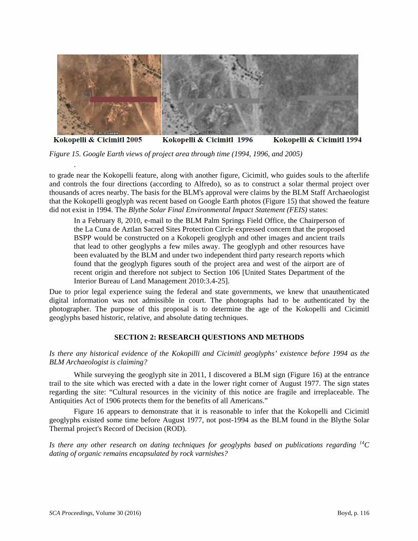
Figure 15. Google Earth views of project area through time (1994, 1996, and 2005)
.
to grade near the Kokopelli feature, along with another figure, Cicimitl, who guides souls to the afterlife and controls the four directions (according to Alfredo), so as to construct a solar thermal project over thousands of acres nearby. The basis for the BLM's approval were claims by the BLM Staff Archaeologist that the Kokopelli geoglyph was recent based on Google Earth photos (Figure 15) that showed the feature did not exist in 1994. The Blythe Solar Final Environmental Impact Statement (FEIS) states:
In a February 8, 2010, e-mail to the BLM Palm Springs Field Office, the Chairperson of the La Cuna de Aztlan Sacred Sites Protection Circle expressed concern that the proposed BSPP would be constructed on a Kokopeli geoglyph and other images and ancient trails that lead to other geoglyphs a few miles away. The geoglyph and other resources have been evaluated by the BLM and under two independent third party research reports which found that the geoglyph figures south of the project area and west of the airport are of recent origin and therefore not subject to Section 106 [United States Department of the Interior Bureau of Land Management 2010:3.4-25].
Due to prior legal experience suing the federal and state governments, we knew that unauthenticated digital information was not admissible in court. The photographs had to be authenticated by the photographer. The purpose of this proposal is to determine the age of the Kokopelli and Cicimitl geoglyphs based historic, relative, and absolute dating techniques.
SECTION 2: RESEARCH QUESTIONS AND METHODS
Is there any historical evidence of the Kokopilli and Cicimitl geoglyphs’ existence before 1994 as the BLM Archaeologist is claiming?
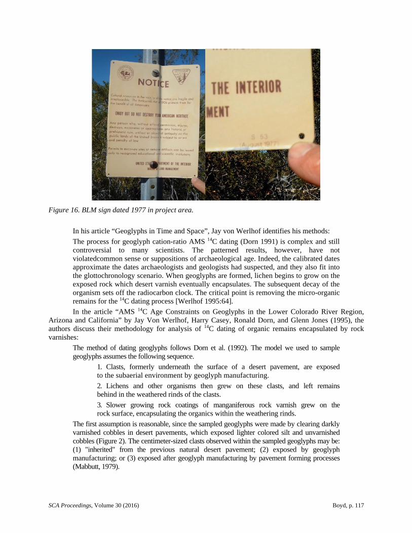
While surveying the geoglyph site in 2011, I discovered a BLM sign (Figure 16) at the entrance trail to the site which was erected with a date in the lower right corner of August 1977. The sign states regarding the site: “Cultural resources in the vicinity of this notice are fragile and irreplaceable. The Antiquities Act of 1906 protects them for the benefits of all Americans.”
Figure 16 appears to demonstrate that it is reasonable to infer that the Kokopelli and Cicimitl geoglyphs existed some time before August 1977, not post-1994 as the BLM found in the Blythe Solar Thermal project's Record of Decision (ROD).
Is there any other research on dating techniques for geoglyphs based on publications regarding 14C dating of organic remains encapsulated by rock varnishes?
SCA Proceedings, Volume 30 (2016) Boyd, p. 117
Figure 16. BLM sign dated 1977 in project area.
In his article “Geoglyphs in Time and Space”, Jay von Werlhof identifies his methods:
The process for geoglyph cation-ratio AMS 14C dating (Dorn 1991) is complex and still controversial to many scientists. The patterned results, however, have not violatedcommon sense or suppositions of archaeological age. Indeed, the calibrated dates approximate the dates archaeologists and geologists had suspected, and they also fit into the glottochronology scenario. When geoglyphs are formed, lichen begins to grow on the exposed rock which desert varnish eventually encapsulates. The subsequent decay of the organism sets off the radiocarbon clock. The critical point is removing the micro-organic remains for the 14C dating process [Werlhof 1995:64].
In the article “AMS 14C Age Constraints on Geoglyphs in the Lower Colorado River Region, Arizona and California” by Jay Von Werlhof, Harry Casey, Ronald Dorn, and Glenn Jones (1995), the authors discuss their methodology for analysis of 14C dating of organic remains encapsulated by rock varnishes:
The method of dating geoglyphs follows Dorn et al. (1992). The model we used to sample geoglyphs assumes the following sequence.
1. Clasts, formerly underneath the surface of a desert pavement, are exposed to the subaerial environment by geoglyph manufacturing.
2. Lichens and other organisms then grew on these clasts, and left remains behind in the weathered rinds of the clasts.
3. Slower growing rock coatings of manganiferous rock varnish grew on the rock surface, encapsulating the organics within the weathering rinds.
The first assumption is reasonable, since the sampled geoglyphs were made by clearing darkly varnished cobbles in desert pavements, which exposed lighter colored silt and unvarnished cobbles (Figure 2). The centimeter-sized clasts observed within the sampled geoglyphs may be: (1) "inherited" from the previous natural desert pavement; (2) exposed by geoglyph manufacturing; or (3) exposed after geoglyph manufacturing by pavement forming processes (Mabbutt, 1979).
SCA Proceedings, Volume 30 (2016) Boyd, p. 118
The approach used here is to try and select the cobbles exposed by geoglyph manufacturing, based upon field and laboratory characteristics. Clasts inherited from natural pavements adjacent to the geoglyphs were avoided by not collecting well-varnished clasts, by sampling the widest sections of the geoglyphs, and by selecting clasts with calcrete rinds which would indicate a former subsurface position for the clasts. Forty cobbles with only patches of varnish were collected [Werlhof, Casey, Dorn, and Jones 1995].
The results of subsequent analysis were as follows:
Table I presents AMS 14C measurements on organics extracted from underneath rock varnish. Also presented in Table I are concentrations of organic carbon in the "control" weathering rinds and the concentration of organic carbon in the dated material. The cation ratios of the dated samples are provided in Table I for comparison purposes, because these cation ratios assisted in the pre-selection of samples for 14C measurement. We note that these cobbles also had calcrete fragments, indicative of a former position within the soil [Werlhof, Casey, Dorn, and Jones 1995].
In between the Kokopilli and Cicimitl geoglyphs, Figueroa identified a small circular patch of rocks surrounding a 1-m-diameter patch containing dried vegetation and charcoal that he referred to as the "under world" to which the deads’ spirits depart and from which children are also born. This is a suggested test site for limited coring samples for a control chronological reference 14C dating source for validation of AMS 14C dating of organic remains encapsulated by rock varnishes.
Table 1 results follow, showing three different geoglyphs located in the Blythe vicinity of similar manufacture, in order to place the Kokopilli geoglyphs in the proper context and provenience. The vicinity geoglyphs are labelled as Blythe Giant Anthropomorph 1, Blythe Giant Quadruped, and Blythe Giant Anthropomorph 2, with AMS 14C “ages” listed as 1060 ±65, 1145 ±65, and 1195 ±65, respectively (Von Werlhof et al. 1995:Table I).
Is there any other research on dating techniques for geoglyphs based on publications regarding the use of optically stimulated luminescence for dating of quartz buried when the geoglyphs were constructed?
In his article “Dating the Geometric Nasca Lines in the Peruvian Desert”, W. Jack Rink discusses the methodology of optically stimulated luminescence for dating of quartz buried when the geoglyphs were constructed:
Optical luminescence dating is a technique that is greatly improved over old thermoluminescence dating methods on sediments, and is applied for the first time to the problem of dating stone lines in this paper. The ages obtained correspond to the last time the sediment grains were exposed to light. The buried grains record the effects of natural radiation which is detected by their subsequent light emission in the lab….
This measurement yields the radiation dose in the grains during burial (the equivalent dose). The rate of natural irradiation in the burial environment (dose rate) is assessed on site by collecting sediment samples and analyzing them for their radioactive element content, or by direct measurement of the dose rate within the sediment itself. The details of the dating approach from an archaeologist’s perspective are outlined in Rink (2000), and the physical basis of the method is given in Rink (2003) [Rink and Bartoli 2005:392].
At the San Ignacio meseta four samples were dated by OSL (Figures 2 and 3, Table 1). Ages from the trenched area within the built stone line ranged from 1200 ±270 years ago at its base just above the original desert surface, to 720 ±130 years ago for a position about 100 mm higher in the stone line, but 300 mm below its surface. A sample taken in the trench location from below the original desert surface yielded a much older age of >5300 years ago. The fourth sample (PLSI3) was taken about 250 mm below the top of a
SCA Proceedings, Volume 30 (2016) Boyd, p. 119
large stone on the crest of the same stone line, in a location about 15m north-east of the trench location on the crest of the same stone line. It yielded an age of 1440 ±230 years ago. Four OSL ages were also obtained at the Sacramento site (Figures 2 and 4, Table 1). Two samples yielded ages in close agreement with each other: Sac 4 (from beneath a large stone) gave 1470 ±420 years ago and Sac 3 (from a stone accumulation pile) gave 1330 ±290 years ago. Another sample (Sac 1) from a stone accumulation pile gave a much older age of 2380 ±390 years but the small number of aliquots, the strong scattering of the De values (Figure 7) and the problematic preheat plateau data (Figure 6) provide little confidence in this result. The sample of the undisturbed desert surface (60-80mm depth) gave an age of about 12,000 years, which strongly suggests the source of the grains was mainly in situ breakdown of partially exposed rock fragments or downward movement of grains into the desert pavement that had been exposed to light by much earlier events. Figure 8 presents a graphic summary of the dating results….
Studies of the sediments taken within 3 mm of the bottom of the large stone at Sac 4 showed very large doses of 20-40 Gy, consistent with contamination of the sediments with grains resulting from the breakdown of the large stone immediately above. Aliquots with these large doses were excluded from the age calculation." (Rink and Bartoli 2005:394)
CONCLUSIONS
The 14C dating of the desert varnish (manganese stain) cobblestones that outline the images of the geoglyphs may provide scientific evidence of the geoglyphs’ antiquity. This reinforces the indigenous oral history and the Aztec codices of the Vaticanus A and Vindobonensis. It suggests that it is reasonable to infer that the Kokopelli and Cicimitl geoglyphs existed sometime between A.D. 892 and A.D. 997, not the post-1994 date BLM found.
Based on the preliminary analysis of the Treaty of Guadalupe Hidalgo map, followed by a more detailed analysis of primary source information of the Aztec cosmogony and the oral history of the Mexican expansion of the Aztec empire, it is reasonable to infer that the Aztecs at the time of European contact could have their origin in this region between ca. 900 and 1,100 years ago, based on archaeological evidence, and using 14C dating we have found on the Blythe intaglios (Von Werlhof et al. 1995), as well as other geoglyphs, and some petroglyphs. With this context, we get a range of possible dates for Kokopelli and Cicimitl of between 1,100 years ago to sometime before August 1977 based on BLM signage. The remaining research question is whether or not this was the first, or part of a cycle of migrations, by the Aztec peoples in the Americas.
REFERENCES CITED
Chua-Eoan, Howard
2011 Welcome to the Zodiac, Ophiuchus. But Who Are You? Time 14 January.
Colorado River Indian Tribes
2009 About the Mohave, Chemehuevi, Hopi and Navajo Tribes. Electronic document, http://www.crit-nsn.gov/crit_contents/about/, accessed 2016.
Disturnell, John
1847 Mapa de los Estados Unidos de México. Revised Edition. J. Disturnell, New York.
Dorn, Ronald
1991 Rock Varnish. American Scientist 79:542-553.
SCA Proceedings, Volume 30 (2016) Boyd, p. 120
Figueroa, Alfredo Acosta
2002 Ancient Footprints of the Colorado River: La Cuna de Aztlan. Aztec Printing, National City, California.Gardner, Jill K.
2006 The Potential Impact of the Medieval Climatic Anomaly on Human Populations in the Western Mojave Desert. Unpublished Ph.D. dissertation, Department of Anthropology, University of Nevada, Las Vegas.
Humboldt, Alexander von
1804 A Map of New Spain, from 16° to 38° North Latitude Reduced from the Large Map. Longman, Hurst, Rees, Orme and Browne, London.
Johnson, Boma
1985 Earth Figures of the Lower Colorado and Gila River Deserts: A Functional Analysis. Arizona Archaeologist No. 20, Arizona Archaeological Society, Phoenix, Arizona.
Klasky, Philip M.
2009 The Salt Song Trail Map: The Sacred Landscape of the Nuwuvi People. Storyscape Project of the Cultural Conservatory.
Kroeber, A. L.
1925 Handbook of the Indians of California. Bureau of American Ethnology Bulletin No.78. Smithsonian Institution, Washington, D.C.
Mabbutt, J.A.
1979 Pavements and patterned ground in the Australian stony deserts. Stuttgarter Geographische Studen 93:107–123.
New Zodiac Sign Ophiuchus is an Old Hoax: Astrologers Strike Back
2011 International Business Times 15 January.
National Park Service
ca. 2015 History and Culture: A Brief History of the Casa Grande Ruins. U.S. Department of the Interior, National Park Service. Electronic document,
https://www.nps.gov/cagr/learn/historyculture/index.htm, accessed April 20, 2015.
Rink, W. J.
2000 Beyond 14C dating: a user’s guide to long-range dating methods in archaeology. In Earth Sciences and Archaeology, edited by P. Goldberg, V.T. Holliday, and C.R. Ferring, pp. 385-418. Kluwer Academic/Plenum, New York.
Rink, W. J.
2003 Electron spin resonance and luminescence dating: principles and applications. Physics in Canada 59: 275-84.
Rink, W. J. and J. Bartoll
2005 Dating the Geometric Nasca Lines in the Peruvian Desert. Antiquity 79:390-401.
Sutton, Mark Q., Mark E. Basgall, Jill K. Gardner, and Mark W. Allen
2006 Advances in Understanding Mojave Desert Prehistory. In California Prehistory: Colonization, Culture, and Complexity, edited by Terry L Jones and Kathryn A. Klar, pp. 229-245. Alta Mira Press, Lanham, Maryland.
SCA Proceedings, Volume 30 (2016) Boyd, p. 121
United Nations Educational, Scientific and Cultural Organization (UNESCO)
2015 Archaeological Zone of Paquime, Casas Grandes. Electronic document, http://whc.unesco.org/en/list/560, accessed April 20, 2015.
United States Department of the Interior Bureau of Land Management (BLM)
2014 Yuma Blythe Intaglios, Electronic document, http://www.blm.gov/az/st/en/prog/ cultural/intaglios.html, accessed April 20, 2015.
United States Department of the Interior Bureau of Land Management (BLM)
2010 Blythe Solar Power Project Plan Amendment/Final Environmental Impact Statement Electronic document, http://www.blm.gov/pgdata/etc/medialib/blm/ca/pdf/palmsprings/ blythe_feis0.Par.77947.File.dat/Blythe%20FEIS%20Comments.pdf, accessed April 20, 2015.
Von Werlhof, Jay
1995 Geoglyphs in Time and Space. Proceedings of the Society for California Archaeology 8:61-68.
Von Werlhof, Jay, Harry Casey, Ronald I. Dorn, and Glenn A. Jones
1995 AMS 14C Age Constraints on Geoglyphs in the Lower Colorado River Region, Arizona and California. Geoarchaeology 10:257-273.
Warren, Claude N.
1984 The Desert Region. In California Archaeology, by Michael J. Moratto, pp. 339-430. Academic Press, Orlando, Florida.
Warren, Claude N., and Robert H. Crabtree
1986 Prehistory of the Southwestern Area. In Great Basin, edited by Warren L. d’Azevedo, pp. 183-193. Handbook of North American Indians, Vol. 11, William C. Sturtevant, general editor. Smithsonian Institution, Washington, D.C.