Embed Size (px)
Citation preview

Service Assessment
La Plata, Maryland, Tornado OutbreakApril 28, 2002
U.S. DEPARTMENT OF COMMERCENational Oceanic and Atmospheric AdministrationNational Weather ServiceSilver Spring, Maryland

Cover Photos:Top left: April 28, 2002, La Plata supercell. (Courtesy of William Rison)Top right: The La Plata tornado moving southeast across Chesapeake Bay as a waterspout.
Photograph taken from Long Beach, Maryland, April 28, 2002. (Courtesy ofTed L. Dutcher)
Bottom left: La Plata, Maryland, tornado tracking map. (National Oceanic and AtmosphericAdministration [NOAA])
Bottom right: CVS drugstore in La Plata, Maryland. (Courtesy of Dawn Glencer)

Service Assessment
La Plata, Maryland, Tornado Outbreak of April 28, 2002
September 2002
U.S. DEPARTMENT OF COMMERCEDonald L. Evans, Secretary
National Oceanic and Atmospheric AdministrationVice Admiral Conrad C. Lautenbacher, Jr.
National Weather ServiceJohn J. Kelly, Jr., Assistant Administrator

ii
Preface
A violent tornado, rated F4 on the Fujita Tornado Intensity Scale (see appendix A),moved across southern Maryland and devastated the town of La Plata. Tornadoes along theAtlantic coast are not common, and tornadoes of this magnitude are extremely rare. Only sixF4 tornadoes have occurred farther north and east of the La Plata storm: Worchester,Massachusetts - 1953; New York/Massachusetts - 1973; Windsor Locks, Connecticut - 1979;five counties in New York - 1989; New Haven, Connecticut - 1989; North Egremont,Massachusetts - 1995. None were as close to the coast. The tornado traveled across theChesapeake Bay almost to the Atlantic.
Due to the magnitude and rarity of this event in this part of the country, a serviceassessment team was formed to examine the warning and forecast services provided by theNational Weather Service (NWS) to emergency managers, government agencies, and the publicin southern Maryland. Service assessments provide a valuable contribution to our ongoingefforts to improve the quality and timeliness of our products and services for the protection oflife and property. Findings and recommendations from this assessment will improve techniques,products, and services.
John J. Kelly, Jr.Assistant Administrator for Weather Services
September 2002

iii
Table of ContentsPage
Preface . . . . . . . . . . . . . . . . . . . . . . . . . . . . . . . . . . . . . . . . . . . . . . . . . . . . . . . . . . . . . . . . . . . . . ii
Service Assessment Team . . . . . . . . . . . . . . . . . . . . . . . . . . . . . . . . . . . . . . . . . . . . . . . . . . . . . . iv
Acronyms . . . . . . . . . . . . . . . . . . . . . . . . . . . . . . . . . . . . . . . . . . . . . . . . . . . . . . . . . . . . . . . . . . . . v
Service Assessment Report . . . . . . . . . . . . . . . . . . . . . . . . . . . . . . . . . . . . . . . . . . . . . . . . . . . . . . 1
Facts . . . . . . . . . . . . . . . . . . . . . . . . . . . . . . . . . . . . . . . . . . . . . . . . . . . . . . . . . . . . . . . . . . . . . . . 19
Findings and Recommendations . . . . . . . . . . . . . . . . . . . . . . . . . . . . . . . . . . . . . . . . . . . . . . . . . 21
Best Practices . . . . . . . . . . . . . . . . . . . . . . . . . . . . . . . . . . . . . . . . . . . . . . . . . . . . . . . . . . . . . . . . 23
Appendix A Fujita Tornado Intensity Scale . . . . . . . . . . . . . . . . . . . . . . . . . . . . . . . . . . . . . A-1
Appendix B Maryland Tornado Fatalities . . . . . . . . . . . . . . . . . . . . . . . . . . . . . . . . . . . . . . . B-1
Appendix C Maryland Tornado Outbreak of April 28, 2002, WFO Baltimore/Washington Chronological Product Highlights . . . . . . . . . . . C-1
iv
Service Assessment Team
The service assessment team was activated on May 1, 2002. Team members visited theLa Plata, Maryland, damage area, Charles and Calvert County emergency management, localradio and TV stations, and the Weather Forecast Office (WFO) Baltimore/Washington. Inaddition, telephone interviews were conducted with the Storm Prediction Center (SPC) andWFO Wakefield, Virginia. The team comprised the following individuals.
John Ogren Team Leader, Meteorologist in Charge (MIC), WFO Indianapolis, Indiana
Richard Kane Warning Coordination Meteorologist (WCM), WFO Pittsburgh,Pennsylvania
Steve Brueske Science and Operations Officer (SOO), WFO Charleston, South Carolina
Michael Vescio SOO, WFO Ft. Worth, Texas
John Leslie Public Affairs Specialist, NWS Headquarters, Silver Spring, Maryland
Wayne Presnell NWS Headquarters, Office of Climate, Water, and Weather Services(OCWWS), Silver Spring, Maryland
Tim Marshall Consultant, Haag Engineering, Carrollton, Texas
Other valuable contributors include:
William Lerner NWS Headquarters, OCWWS, Silver Spring, Maryland
Linda Kremkau NWS Headquarters, OCWWS, Silver Spring, Maryland
Special thanks to:
Frank Lucia Federal Communications Commission, Retired

v
Acronyms
AWIPS Advanced Weather Interactive Processing SystemBPAT Building Performance Assessment TeamCWA County Warning AreaEAS Emergency Alert SystemEDT Eastern Daylight TimeFCC Federal Communications CommissionFEMA Federal Emergency Management AgencyHMT Hydrometeorological TechnicianMIC Meteorologist in ChargeNAWAS National Warning SystemNCF Network Control Facility NOAA National Oceanic and Atmospheric AdministrationNWR NOAA Weather RadioNWS National Weather ServiceOCWWS Office of Climate, Water, and Weather ServicesQRT Quick Response TeamSAME Specific Area Message EncodingSOO Science and Operations OfficerSPC Storm Prediction CenterTVS Tornado Vortex SignatureWCM Warning Coordination MeteorologistWDM Warning Decision MakingWERC Wind Engineering Research CouncilWES Weather Event SimulatorWFO Weather Forecast OfficeWSR-88D Weather Surveillance Radar-1988 Doppler

1
Service Assessment Report
Introduction
On Sunday evening, April 28, 2002, a violent F4 tornado carved a 64-mile path acrosssoutheast Maryland. The La Plata, Maryland, tornado was part of a large severe weatheroutbreak that began in the mid-Mississippi Valley early on that day and spread across portions ofthe Ohio Valley and Mid-Atlantic States. In Maryland, 3 deaths and 122 injuries were a directresult of the storm (see appendix B). Property damage exceeded $100 million. This is not thedeadliest tornado to strike La Plata. In 1926, a tornado killed 14 children at a school.
An NWS service assessment team was formed to review the products and servicesprovided by the Storm Prediction Center (SPC) and the Weather Forecast Offices (WFOs)Baltimore/Washington and Wakefield, Virginia. Emergency managers, people in the media, andlocal residents were interviewed to obtain feedback on NWS performance. The assessment teamlearned NWS customers and partners were satisfied with the information received before andduring the La Plata tornado. Critical warnings reached the public despite the failure of one partof the dissemination system (see “Dissemination” section). NWS policy of using multipledissemination methods worked during this event and remains a vital component of the NWSmission of protecting life and property.
One purpose of service assessments is to identify issues and recommend improvements. In this case, the La Plata service assessment team identified three such issues: Emergency AlertSystem (EAS), WFO Baltimore/Washington warning decision process, and tornado intensityrating. These are discussed in detail in this report.
Overview
The weather system spawning the La Plata tornado contained the large-scale featurestypical of significant severe weather episodes (see figures 1a and 1b). A strong upper-leveltrough moved rapidly from the Ohio Valley to the Mid-Atlantic coast during the day. Jet streamwinds greater than 90 mph were associated with the upper system and contributed to anatmosphere conducive to the development of supercell thunderstorms and tornadoes. Supercellthunderstorms are the most violent type of severe thunderstorm and produce large hail,damaging winds, and the majority of the tornadoes that occur across the United States. Supercellthunderstorms developed during the late morning over Ohio and Kentucky along a strong coldfront and in association with the upper system. These storms raced eastward and crossed the

2
Figure 1a. Composite map from 7 a.m. EDT, Sunday, April 28,2002, depicting the surface fronts, surface dew points (dashedlines) and upper level jet stream wind (solid lines). (NOAA)
Figure 1b. Composite map from 7 p.m. EDT, Sunday, April 28,2002, depicting the surface fronts, surface dew points (dashedlines) and upper level jet stream wind (solid lines). (NOAA)

1 All times listed in this service assessment are EDT.
3
Appalachian Mountains between 3 and 4 p.m. Eastern Daylight Time (EDT).1 Many of thestorms weakened as they crossed the high peaks of the Blue Ridge Mountains. However, thestorm that struck La Plata remained a strong supercell as it moved from West Virginia throughnorthern Virginia into southern Maryland.
In the La Plata area, a warm front was located just south of the town early Sundaymorning (see figure 1a). Cool air reinforced by clouds and precipitation led to a stable air massearly in the day. However, the warm front moved north of the area by midday (see figure 1b),resulting in rapid air mass destabilization and provided ideal conditions for severe weather as thesupercell moved into the area.
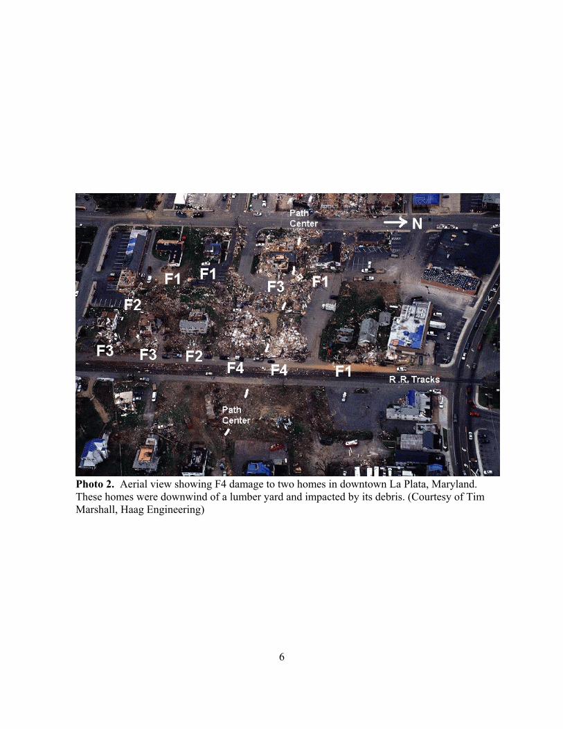
The La Plata tornado first touched down at 6:56 p.m., south of the town of Marbury inwestern Charles County, Maryland (see photo 1, aerial view of the tornado track; and figure 2,map of the entire tornado track and an inset of the tornado path through La Plata). Althoughinitial damage was minimal, the tornado intensified as it approached the town of La Plata, andF3 damage occurred in two subdivisions west of town. Damage and eye witness accountsindicate a second weaker tornado formed a quarter of a mile south of the first tornado. Bothtornadoes crossed the heart of La Plata between 7:02 p.m. and 7:07 p.m., causing widespread F2-F3 damage. Destruction in a one-square-block area on the east side of La Plata was most severeand rated F4 (see photo 2 of downtown La Plata F4 damage). The secondary tornado dissipatedwhile the main tornado continued moving east through the rest of Charles County. Althoughmuch of the area east of La Plata was rural, 100 homes, 49 businesses, and numerous barns weredestroyed. Acres of dense forest were leveled. At 7:30 p.m., the tornado crossed into CalvertCounty where it killed an elderly couple and destroyed an additional 10 homes and damagedanother 125. It moved out onto the Chesapeake Bay just north of the Calvert Cliffs NuclearPower Plant. A secondary vortex, a waterspout, formed for a few miles on the Bay. Theprimary tornado continued across Dorchester County again intensifying to F3 before dissipatingas it approached Salisbury, Maryland.
WFO Baltimore/Washington has warning and forecast responsibility for a small part ofthe West Virginia Panhandle, extreme northern Virginia, and most of Maryland, includingCharles and Calvert Counties. On the day of the tornado, the office issued all its routineproducts, a 13-county flood watch, a flash flood warning, 14 tornado warnings, 13 severethunderstorm warnings, 4 special marine warnings, plus many special and severe weatherstatements. The Science and Operations Officer (SOO) stated that April 28 was “the busiest dayhe had worked in the last 8 years.”
The forecast office issued its first tornado warning for Shenandoah County, Virginia, at4:37 p.m. for the thunderstorm that eventually spawned the La Plata tornado. The stormproduced a tornado south of Mount Jackson at 4:55 p.m. Subsequent tornado warnings were

4
Photo 1. Aerial view of tornado path looking east toward La Plata, Maryland. Dots indicatethe center of damage path. The tornado traveled through the Quailwood Subdivision in theforeground destroying several homes along Morgans Ridge Road. (Courtesy of Tim Marshall,Haag Engineering)

5
Figure 2. Map of the tornado track and an inset of the tornado track through LaPlata, MD. (NOAA)
6
Photo 2. Aerial view showing F4 damage to two homes in downtown La Plata, Maryland. These homes were downwind of a lumber yard and impacted by its debris. (Courtesy of TimMarshall, Haag Engineering)

7
issued along the storm’s path across northern Virginia through 6:45 p.m., but no additionaltornadoes occurred. A severe thunderstorm warning was issued for northern Charles and CalvertCounties at 6:45 p.m. The call-to-action statement mentioned the possibility of tornadoes: “SEVERE THUNDERSTORMS CAN PRODUCE TORNADOES WITH LITTLE OR NOADVANCE WARNING....” At 7:02 p.m., 6 minutes after the tornado touched down, the tornadowarning was issued for Charles and Calvert Counties.
Warning and Forecast Services
WFO Baltimore/Washington
Before the Event
The Baltimore/Washington WFO preplanning was excellent. Awareness of the potential forsevere weather prior to the onset of this event was extremely high. Planning began Saturdayafternoon, April 27, the day before the tornado. People scheduled on the Sunday, April 28, eveningshift were prepared to come in early should severe weather develop. The Network Control Facility(NCF) was notified at 8:30 a.m., Sunday morning, April 28, to put the Baltimore/Washington WFOin a critical weather watch for the Advanced Weather Interactive Processing System (AWIPS). TheNCF serves as the AWIPS control center and identifies, diagnoses, and corrects system faults andoutages; monitors site equipment operations; and alerts users at each site when malfunctions ordegradations occur. During critical weather situations, the WFO may ask the NCF to keep a closereye on AWIPS operations. Two additional forecasters arrived at the WFO by 2 p.m. and anadditional Hydrometeorological Technician (HMT) arrived by 4 p.m. A short meeting was held at3 p.m., Sunday, April 28, to determine staff responsibilities.
Several outlook and forecast products were issued for the severe weather threat over Virginiaand Maryland. The first mention of possible severe weather was in the Baltimore/Washington WFO’s Hazardous Weather Outlook issued at 5:25 a.m., Saturday, April 27. It stated,“SOME OF THESE STORMS MAY BE ON THE STRONG SIDE...WITH GUSTY WINDS THEPRIMARY THREAT.” At 3:20 a.m., Sunday, April 28, another Hazardous Weather Outlook washeadlined, “POSSIBLE SEVERE THUNDERSTORMS TODAY.” The Outlook focused ondamaging winds during the afternoon. The 10:30 a.m., Sunday, April 28, Hazardous WeatherOutlook was the first to mention a tornado threat and gave the specific times: between 3 p.m. and 8p.m. SPC issued a tornado watch at 3:30 p.m.

8
During the Event
The Baltimore/Washington WFO was staffed with eight people, including the Meteorologistin Charge (MIC), Warning Coordination Meteorologist (WCM), SOO, three lead forecasters, andtwo HMTs.
The WFO began issuing warnings when the La Plata supercell first entered its countywarning area (CWA). Warning forecasters issued the first tornado warning for Shenandoah County,Virginia, at 4:37 p.m., and a tornado touched down south of Mount Jackson at 4:55 p.m. This F2tornado destroyed 3 homes, 19 barns, and damaged 27 other residences. While the WFO receivedconfirmation of the Shenandoah tornado, this confirmation was not passed to the warning forecastersduring the event. Based on radar, the warning forecasters issued additional tornado warningsbetween 5 and 6:45 p.m. as the storm crossed Virginia. SKYWARN spotters and county warningpoints reported a funnel cloud, wind damage, and large hail associated with the storm, but noadditional tornadoes. Without a confirmed tornado report, and believing the supercell’s tornadicpotential was decreasing, the warning forecasters issued a severe thunderstorm warning for Charlesand Calvert Counties at 6:45 p.m. The call-to-action statement in the severe thunderstorm warningdid state, “SEVERE THUNDERSTORMS CAN PRODUCE TORNADOES WITH LITTLE OR NOADVANCE WARNING....”
Another forecaster working the severe weather episode called the Charles County 9-1-1 Operations Center between 6:10 and 6:20 p.m. to discuss the approaching storm. Thisforecaster stated, “There is a tornadic thunderstorm headed your way.” Charles County personnelinformed the forecaster they were watching the storm on radar and knew they were in a tornadowatch.
The thunderstorm crossed the Potomac River into Maryland where the La Plata tornado firsttouched down near Marbury at 6:56 p.m. At 7:02 p.m., 6 minutes after the tornado touched down, atornado warning was issued for Charles and Calvert Counties. As the tornado warning was beingissued, another forecaster called Charles County personnel in La Plata to warn them that radarindicated a tornado, but it took three attempts to get through because damage calls from Ripley andother locations west of La Plata were already clogging the telephone lines. The first fatalityoccurred 8 minutes later at 7:10 p.m. in La Plata. At 7:30 p.m., two more people died as the tornadoentered Calvert County. See appendix C for WFO Baltimore/Washington chronological producthighlights.
After the Event/Damage Assessment
Tornadoes are rated using the Fujita Tornado Intensity Scale or F-scale, which is named afterDr. T. Theodore Fujita, former professor of Meteorology, University of Chicago. The F-scale is a subjective visual interpretation used by the NWS to rate the worst building damageanywhere along the path from 0 to 5, with 5 being the most destructive (see appendix A). Empirically-derived wind speed ranges are also associated with the F-scale. An accurate F-scalerating is important for historical, statistical, and climatological reasons and allows the public to get asense of the storm’s destructive force.

9
WFOs assign an F-scale rating for tornadoes occurring in their CWAs except when a serviceassessment is undertaken. In those cases, the WFO rating is preliminary and the assessment team incoordination with the WFO assigns a final F-scale. WFO Baltimore/Washington surveyed the damage in La Plata, Monday, April 29. The WFO first rated the tornadoan F4, but later raised the assessment to F5, based on building damage just east of downtown LaPlata. This information was disseminated to the public and media through Public InformationStatements and a news story prepared by the NWS Public Affairs Office without a “preliminary”indicator. Subsequent updates to the news story did contain the word “preliminary.” Current policystates “preliminary” should be used whenever a service assessment is possible. (Weather ServiceOperations Manual Chapter J-02, Significant Hydrometeorological Events, Post-storm DataAcquisition, and Service Assessments, section 6: “If unsure whether a service assessment...isneeded, the local office shall indicate that F-scale determinations are preliminary and subject torevision after further analysis.”) The assessment team concluded the Baltimore/Washington WFOwas unsure if a service assessment would be undertaken. Also, the assessment team questionedwhether “preliminary” is a strong enough word to allow for any subsequent change to the rating. (Finding 1)
As mentioned above, Baltimore/Washington WFO personnel rated the worst damage F5. This preliminary F5 rating to a brick building in downtown La Plata (see photo 3) was lowered to F4after the assessment team determined some of the damage was due to flying debris from a lumbercompany upwind. Damage to homes rated F5 by the WFO were lowered to F4 when the assessmentteam’s structural engineer, Tim Marshall, performed a detailed analysis of the construction. Hedetermined these homes were not adequately anchored causing them to fail at a lesser wind force(see photos 4 and 5). In some cases, destroyed homes still had mailboxes and storage sheds leftintact (see photo 6). WFO personnel who are trained in damage assessment receive it only once. Inaddition, violent F4 and F5 tornadoes are extremely rare, and there are few opportunities to viewstorm damage of this magnitude. (Finding 2)
The assessment team learned building damage surveys were being done by the FederalEmergency Management Agency’s (FEMA) Building Performance Assessment Team (BPAT) andWind Engineering Research Council (WERC) at the same time the NWS was conducting theirdamage survey. (Finding 3)
After the tornado event on Sunday, April 28, Jim Travers, MIC, and Barbara Watson, WCM,WFO Baltimore/Washington, spent approximately 12 hours conducting interviews with national andlocal media. Most media reports were positive or neutral. A Public Affairs officer was present atthe WFO Baltimore/Washington all day, Monday, April 29, and most of the next day. NOAApraised NWS Public Affairs staff for preparing news stories and updates.

10
Photo 3. Aerial view of a lumber yard and downed water tower in downtown LaPlata, Maryland. (Courtesy of Tim Marshall, Haag Engineering)
Photo 4. Aerial view of residential damage in the Quailwood Subdivision lookingeast. Several poorly attached homes slid off their foundations and rated F1. (Courtesyof Tim Marshall, Haag Engineering)

11
Photo 5. Aerial view looking east of residential damage at end of Hawkins GateRoad, located just east of La Plata, Maryland. Split-level homes slid off theirfoundations into a ravine. The home had been anchor-bolted to its foundation butfailed where the wall studs were straight nailed to the bottom plate. (Courtesy ofTim Marshall, Haag Engineering)
Photo 6. Poorly anchored home on Morgans Ridge Road was swept clean off itsfoundation while mailboxes remained undamaged. This example illustrates thedifficulties in assigning an F-scale rating. (Courtesy of Tim Marshall, HaagEngineering)
12
WFO Performance
WFO Baltimore/Washington fulfilled its mission by issuing timely warnings, forecasts, andstatements, and maintaining frequent contact with partners. Customers and partners were satisfiedwith the services provided. The team did note some areas where services could be improved.
The assessment team focused on why the warning forecasters decided to issue a severethunderstorm warning rather than a tornado warning for Charles County and La Plata when tornadowarnings had been issued for this storm in Virginia. Based on their responses, the assessment teamidentified four factors: warning forecasters did not receive a confirmed report of a tornado; radarindications of a weakening supercell; lack of a continuous weather watch on the supercell; andconcern over false alarms. The combination of these four factors led to the decision to issue a severethunderstorm warning. (Finding 4)
Warning forecasters did not receive a confirmed report of a tornado. As mentioned earlier,WFO staff received confirmation of a tornado in Shenandoah County, but this confirmation was notcommunicated to the warning forecasters. WFO Baltimore/Washington policy states when a personreceives a severe weather report, this information is to be passed immediately to the warning team.
The NWS offers a 4-day Warning Decision Making (WDM) Workshop. One of the subjectsis “Strategies for Optimizing Severe Weather Performance.” A key topic covered is the importanceof effective communication within the office: “Do everything you can to ensure critical informationis relayed to those who need it as quickly as possible and that open communication is encouraged.”
Radar indications of a weakening supercell. Based on radar indications, the warningforecasters thought the storm was weakening and losing its potential to produce a tornado. Assessment team members reviewed the archived data from the Weather Surveillance Radar-1988Doppler (WSR-88D) and found the significant hook echo, or pendant, evident on the lowest radarscans from 6:10 to 6:20 p.m. on the southwest side of the storm, had dissipated by the 6:30 to 6:40p.m. scans. Hook echos at low levels are frequently indicative of rotating storms and often indicatetornadoes, but are only one of the several signatures available to identify severe storms. In addition,at 6:20 p.m., the WSR-88D’s algorithms did not indicate a mesocyclone (a deep, symmetrical,rotating vortex) or a Tornado Vortex Signature (TVS) previously identified in the storm. Cycles ofweakening and regeneration are common in long-lived supercell thunderstorms.
Despite the loss of the hook echo signature, at 6:35 p.m. the radar’s Tornado VortexDetection algorithm indicated a TVS that extended from the lowest level observed by the radar(1,800 feet above ground at the particular storm’s location) to over 10,000 feet. The detection ofthis signature automatically triggered an alarm on the AWIPS that the warning forecasters noticed. In addition, the radar’s mesocyclone detection algorithm identified a mesocyclone within the stormthat extended from 9,200 feet to 20,500 feet within the storm. From 6:35 p.m. (21 minutes beforetornado touchdown) until the storm reached the Patuxent River over an hour later, the WSR-88D’salgorithms continuously identified both the mesocyclone and TVS. This final TVS was the firstsignature associated with a tornado since the Shenandoah storm.

13
The WDM Workshop provides guidelines on optimizing procedures for efficient analysis ofsevere weather. The guidelines recommend “Be very slow to downgrade from a Tornado Warningto a Severe Thunderstorm Warning.” Eastern Region’s Severe Weather Best Practices Web sitestates, “It is a good rule of thumb to continue tornado warnings for a few volume scans followingthe dissipation of the radar-observed vortex signature.”
Lack of a continuous weather watch on the supercell. Two forecasters combined their effortsto issue warnings for the entire CWA. When the La Plata tornado first touched down, the warningforecasters were issuing a severe thunderstorm warning for Anne Arundel, Howard, andMontgomery Counties in Maryland at 6:58 p.m. This practice prevented a full weather watch by thewarning team on more than one part of the CWA at any given time.
The May 3, 1999, Oklahoma/Southern Kansas Tornado Outbreak Service Assessmentrecommends as a best practice “Sectorization of Warning Operations.” The Performance Strategiessection of the WDM Workshop recommends use of a team-centered approach of sectorizedoperations using multiple workstations.
Concern over false alarms. In recent years, the NWS has emphasized improving productsand services. The warning forecasters believed the emphasis was on verification scores and thatperception led to false alarm concerns. In this case, several tornado warnings issued for Virginiahad not verified.
Eastern Region’s Severe Weather Best Practices Web site states, “When supercells arepossible and/or indicated by radar, it is important to err on the side of safety and issue a tornadowarning,” and “Since supercells are relatively rare, we are not increasing the FAR [False AlarmRate] much if a given supercell...doesn’t produce a tornado.” In November 2000, the Director,Eastern Region, discussed the importance of performance rather than focusing on statisticalmeasures of performance, including false alarm rates, with the WFO Baltimore/Washington staff.

14
WFO Wakefield, Virginia
The WFO in Wakefield, Virginia, provided good warning and forecast services for theLa Plata tornado as it moved through Dorchester and Wicomico Counties. WFO Wakefield’s CWAwas located on the southeastern fringe of the severe weather area that occurred on Sunday, April 28. SPC outlooks indicated Wakefield’s CWA had a slight risk of severe weather and WFO Wakefield’spublic products blended well with these outlooks.
The La Plata tornado crossed the Chesapeake Bay, moved across Dorchester County withmaximum F3 intensity, and dissipated in Wicomico County. Tornado warnings were issued for bothcounties. Lead time was 11 minutes for Dorchester County, and 7 minutes for Wicomico County. There were no fatalities or injuries, all systems performed adequately, and staffing was sufficient forthe event.
Storm Prediction Center
The SPC, part of the National Centers for Environmental Prediction, provided good outlookand watch services for the April 28 severe weather outbreak.
The SPC put much of the Mid-Atlantic region in a slight risk of severe weather in the Day 2Outlook issued at 3 a.m., Saturday, April 27. The Outlook stated the primary risk was for damagingwinds. However, the Outlook stated, “THE TORNADO/HAIL THREAT IS CONDITIONALBASED ON THE DEGREE OF DESTABILIZATION. IF CONFIDENCE INCREASES...ANINCREASE TO MODERATE RISK MAY BE NECESSARY.”
The Day 1 Outlook, issued at 2 a.m., Sunday, April 28, forecast a moderate risk of severeweather for the central Appalachians and the Mid-Atlantic States. The Outlook stated the primarythreat was for widespread damaging winds. An update was issued at 9 a.m., stating, “ISOLATEDTO SCATTERED SEVERE STORMS...POSSIBLY SUPERCELLS...CANNOT BE RULED OUTFROM THE D.C. AREA ACROSS VA. DURING THE EVENING.” SPC issued a tornado watchat 3:05 p.m., valid from 3:30 p.m. until 9 p.m., for Washington, DC; Maryland; and western andcentral Virginia.
Partner and Customer Coordination and Response
The effectiveness of the weather warning system is dependent on close coordination,cooperation, and a clear consistent message among the various agencies responsible for publicsafety. This includes the NWS, the media, and state and local governments. Customers said theywere satisfied with the warning, forecast, and other services provided before, during, and after theevent.

15
Emergency Management
There is excellent communication between WFO Baltimore/Washington and state and localemergency management. When asked, Charles County Emergency Management Director, DonMcGuire, stated, “We have a very good working relationship with the Baltimore/Washington NWS office. We routinely call the office for weather updates.” This sentiment wasechoed by Calvert County Emergency Management Director, Don Hall. A review of the past2 years of emergency management contacts show numerous meetings where issues were discussed.
Mr. McGuire said he was very pleased with the speed at which the WFO Baltimore/Washington conducted the preliminary investigation the day immediately after the storm. By mid-week, the potential for more severe weather threatened recovery and cleanup operations. The NWSprovided frequent and timely weather briefings to the Emergency Operations Center throughout theafternoon of Thursday, May 2. The Charles County emergency management director was verygrateful for the additional weather support by the NWS.
Media
Overall, the Washington, DC, area television weathercasters complimented the WFOBaltimore/Washington on the quality of service. None of the TV weathercasters mentionedproblems receiving the warnings and forecasts from the Baltimore/Washington WFO. For example,Tony Pann, weekend meteorologist at the CBS affiliate WUSA-TV (Channel 9), said the servicesand products from WFO Baltimore/Washington during the April 28 tornado event were“outstanding, excellent, timely, and the duration of the warnings was very good.” Topper Shutt,chief meteorologist at the station said, “[WFO] Sterling could have been a little ahead of the gamewith the Charles County tornado warning, but I am very happy with their services during thisevent.”
Doug Hill, the chief meteorologist at the ABC affiliate WJLA-TV (Channel 7), said,“Jim Travers runs a great shop.” However, he added the NWS should look into installinga separate telephone line only for local TV weathercasters to access a forecaster. TheBaltimore/Washington WFO, as do many forecast offices, has a media line. During major eventslike this, these phone lines are in heavy use and often busy. Based on the collective expertise andexperience of the assessment team, it concluded additional phone lines will not improve thissituation.
Two local radio stations noted they did not receive EAS activation notification. DaveGarner, WTOP radio, Washington, DC, said, “...not receiving the alert [EAS codes] from Sterlingwas unusual. Usually we receive more than we need, an overload.” WTOP radio monitors theManassas, Virginia, NOAA Weather Radio (NWR) transmitter and is the state EAS relay point forthe Washington, DC, metropolitan area. Mike Friedman, WJFK radio, echoed Mr. Garner’scomments noting flood products from the WFO were received during the morning, but no watchesor warnings were received during the afternoon. More detail on this subject is contained in the“Dissemination” section.

16
Radio station WSMD in Mechanicsville, Maryland, serves the southern Maryland listeningarea. The station was off the air during the time the tornado warning was issued due to a powerfailure. When power was restored, the station received the warning from a TV station andrebroadcast it. Station spokeswoman, Heather Kincaid, said she was pleased with WFOBaltimore/Washington’s services during the event.
News articles generally discussed the tornado watch and warnings being issued well inadvance and being widely received. An April 29, 2002, Washington Post article stated, “despitetornado alerts that the NWS began issuing, many people said they had known nothing about theimpending danger.” An April 29, 2002, New York Times article quoted Charles Countyspokeswoman, Nina W. Voehl, “the National Weather Service issued a tornado warning (watch)[sic] four hours before La Plata was hit. But residents said they became aware of one only whenthey saw the tornado and heard it.” This was confirmed in interviews where most people said theywere not paying close attention to the media on a Sunday afternoon.
Public
La Plata area residents interviewed by the assessment team knew severe weather waspossible that afternoon. Most heard watches over The Weather Channel and local TV or radiostations. When warnings where issued, some mentioned local TV stations’ crawlers only containedinformation pertaining to the type of warning and county affected. One Calvert County residentwhose home was just missed by the tornado said, “I saw the tornado warning on Channel 9, then Ididn’t see a thing outside because I ran to my basement!”
Even though a tornado watch was issued well in advance and a severe thunderstorm warningwas in effect 11 minutes before the tornado touched down, people not tuned to a media source didnot believe there was a threat. Most of these people took action based on seeing the tornado orbeing told by neighbors. Many La Plata residents did follow the correct safety procedures by takingshelter from the tornado.
Dissemination
Weather warnings are disseminated by various voice and text methods. The NWS broadcastsover NWR, National Warning System (NAWAS), telephone, and amateur radio networks. Textdissemination methods include NOAA Weather Wire Service, Family of Services, Internet, andEmergency Management Weather Information Network.

17
Emergency Alert System
There was a problem with the EAS activation process. EAS is a Federal CommunicationsCommission (FCC) program for TV and radio stations to relay emergency alerts, including tornadowatches and warnings, to the public. EAS receivers are certified by the FCC. NWS activates EASwith text messages through government and private vendors’ dissemination systems and audiomessages through NWR. TV stations broadcasting in the La Plata listening area had no problemreceiving severe weather warning information during this event. Radio stations use NWR whichactivates EAS when warnings containing digital Specific Area Message Encoding (SAME) arebroadcast. Problems with EAS activation were limited to radio stations.
Radio station WTOP in Washington, DC, is the Local Primary 1 (LP1) EAS station. It distributes information to, and is monitored by, 25 radio stations throughout the Washington, DC,region. Radio station WJFK in Manassas, Virginia, is the Local Primary 2 (LP2) EAS station andserves as a backup to WTOP. Other stations voluntarily monitor NWR as an additional backup toWTOP/WJFK. Team members interviewed the chief engineer at WTOP. He stated the radio stationdid not receive the NWR SAME alerts for tornado watches and warnings issued on Sunday,April 28, and the EAS was not activated for the La Plata tornado. The WTOP engineer also said,“We received flash flood watches earlier in the day but did not receive any watches or warningsduring the afternoon.” Fifty-three percent of radio stations broadcasting into the La Plata listeningarea experienced similar problems.
Frank Lucia (a retired FCC employee and EAS expert) and team members contacted 16 radiostations whose broadcast areas include La Plata. Of the 16, 7 radio stations received all watches andwarnings broadcast via NWR on April 28. The 9 stations that did not, all use FCC-certified equipment manufactured by the same company. Eight of these radio stations receivedwatch and warning information from alternate sources and rebroadcast it to the public.
A test was conducted using the identical NWR SAME location codes as were used on April28. The 9 receivers failed again. In discussions with the company, Mr. Lucia learned when morethan 28 NWR SAME location codes are transmitted to a receiver manufactured in 1996/1997, andthe station’s NWR is plugged into Channel 3 or higher, the system fails. The only WFOs in theNWS that transmit more than 28 NWR SAME location codes on a single transmitter are WFOsBaltimore/Washington and Blacksburg, Virginia. The receiver manufacturer and the radio stationsare working to rectify the problem. (Finding 5)

18
NOAA Weather Radio
NWR is the NWS’s direct method of disseminating weather warnings to the public. SeveralNWS employees received warnings through NWR. However, there is limited knowledge of NWRamong La Plata area residents.
• There was no NWR receiver in the Charles County Sheriff’s office which is the 9-1-1 Operations Center and contact point for the NWS.
• One law enforcement officer mentioned when he sees a warning on TV, he usuallytunes to the main radio station in the area, WSMD. However, the station lost powerand was off the air. This same officer was asked if he owned an NWR receiver. Hedid not know about NWR but when it was described to him, he said, “No, but I’mgoing to get one now!”
• Of the 40 residents interviewed, only one Charles County resident knew about NWRbut heard the warning from a TV station.
WFO Baltimore/Washington has conducted numerous NWR outreach activities. In June2002, Maryland Gov. Parris N. Glendening distributed NWR receivers to all schools in Maryland. This project began well before the La Plata tornado.
NAWAS
NAWAS is a FEMA communications “hotline” used by NWS and state and localemergency management to communicate critical weather information. Maryland’s countyemergency management community relies heavily on the NAWAS circuit for the exchange ofsevere weather information between individual counties and the NWS. Maryland is one of thefew states with an NAWAS drop in each of its counties. However, Charles and Calvert Counties areunable to monitor the exchange of severe weather information between Virginia and the NWS.
The Charles County emergency management director stated he needs more advance noticeand would like a “heads up” when severe weather is over Virginia and before warnings are issuedfor southern Maryland. The assessment team found the WFO communicated directly with CharlesCounty several times before and during the event. This included notification of the tornado watchand the severe thunderstorm and tornado warnings, as well as a “heads-up” call indicating thepotential for tornadic storms about 40 minutes before tornado touchdown. (Finding 6)

19
Facts
Introduction
FACT: On Sunday evening, April 28, 2002, a violent F4 tornado carved a 64-mile pathacross southeast Maryland.
FACT: The assessment team learned NWS customers and partners were satisfied with theinformation received before and during the La Plata tornado.
Overview
FACT: Destruction in a one-square-block area on the east side of La Plata was most severeand rated F4.
Warning and Forecast Services
WFO Baltimore/Washington
Before the Event
FACT: The Baltimore/Washington WFO preplanning was excellent.
During the Event
FACT: Without a confirmed tornado report, and believing the supercell’s tornadic potentialwas decreasing, the warning forecasters issued a severe thunderstorm warning forCharles and Calvert Counties at 6:45 pm.
FACT: At 7:02 p.m., 6 minutes after the tornado touched down, the tornado warning wasissued for Charles and Calvert Counties.
After the Event/Damage Assessment
FACT: Baltimore/Washington WFO personnel rated the worst damage F5.

20
WFO Performance
FACT: The assessment team focused on why the warning forecasters decided to issue asevere thunderstorm warning rather than a tornado warning for Charles County andLa Plata and identified four factors: warning forecasters did not receive a confirmedreport of a tornado; radar indications of a weakening supercell; lack of a continuousweather watch on the supercell; and concern over false alarms.
Partner and Customer Coordination and Response
Emergency Management
FACT: Charles County Emergency Management Director, Don McGuire, stated, “We have avery good working relationship with the Baltimore/Washington NWS office. Weroutinely call the office for weather updates.”
Media
FACT: Topper Shutt, chief meteorologist at the station said, “[WFO] Sterling could havebeen a little ahead of the game with the Charles County tornado warning, but I amvery happy with their services during this event.”
Dissemination
Emergency Alert System
FACT: There was a problem with the EAS activation process. Fifty-three percent of theradio stations broadcasting into the La Plata listening area experienced problems.

21
Findings and Recommendations
Warning and Forecast Services
WFO Baltimore/Washington
After the Event/Damage Assessment
Finding 1: The WFO first rated the tornado an F4, but later raised the assessment toF5. This information was disseminated to the public and media without a“preliminary” indicator. Current policy states “preliminary” should beused whenever a service assessment is possible.
Recommendation 1a: The Office of Climate, Water, and Weather Services (OCWWS) should
create a national Quick Response Team (QRT) to determine the finalrating for all tornadoes suspected to be F4 or F5.
Recommendation 1b: OCWWS should modify appropriate directives and require WFOs to use“potentially greater than F3" whenever tornado damage of F4 or F5intensity is suspected and until the QRT makes its final determination.
Finding 2: WFO personnel who are trained in damage assessment receive it onlyonce. In addition, violent F4 and F5 tornadoes are extremely rare, andthere are few opportunities to view storm damage of this magnitude.
Recommendation 2: OCWWS should provide WFOs with a standardized damage assessmentguide.
Finding 3: The assessment team learned building damage surveys were being doneby the Federal Emergency Management Agency’s (FEMA) BuildingPerformance Assessment Team (BPAT) and Wind Engineering ResearchCouncil (WERC) at the same time the NWS was conducting their damagesurvey.
Recommendation 3: OCWWS should work to establish Memoranda of Understanding with
FEMA and WERC to create a notification process when assessment teamsare deployed.
22
WFO Performance
Finding 4: Warning forecasters decided to issue a severe thunderstorm warning ratherthan a tornado warning for Charles County and La Plata because: warningforecasters did not receive a confirmed report of a tornado; radarindications of a weakening supercell; lack of a continuous weather watchon the supercell; and concern over false alarms.
Recommendation 4a: OCWWS, in cooperation with Regional Scientific Services Divisions,should summarize practices for severe weather operations contained in theWDM Workshop and in service assessment/regional best practices, andprovide material to all WFOs. Internal office communication, radaranalysis, sectoring of warning operations, and performance principlesshould be included.
Recommendation 4b: Regions should ensure WFOs review the severe weather operationssummary material through station drills and a demonstration ofproficiency prior to each severe weather season.
Dissemination
Emergency Alert System
Finding 5: The 9 radio stations that did not receive NWR SAME messages all haveFCC-certified EAS equipment manufactured by the same company. Thereceiver manufacturer and the radio stations are working to rectify theproblem.
Recommendation: 5: OCWWS should monitor actions by the receiver company.
NAWAS
Finding 6: The Charles County emergency management director stated he needsmore advance notice and would like a “heads up” when severe weather isover Virginia and before warnings are issued for southern Maryland.
Recommendation 6: WFO Baltimore/Washington and the Charles County emergencymanagement director should make mutually acceptable modifications tothe communication process to ensure “heads up” when severe weather isover Virginia.

23
Best Practices
1. PreplanningAwareness of the potential for severe weather prior to the onset of this event was extremelyhigh. Planning began Saturday afternoon, April 27, the day before the tornado. Peoplescheduled on the Sunday, April 28, evening shift were prepared to come in early shouldsevere weather develop. The NCF was notified at 8:30 a.m., Sunday morning, April 28, toput the Baltimore/Washington WFO in a critical weather watch for AWIPS. Two additionalforecasters arrived by 2 p.m. and an additional HMT by 4 p.m. A short meeting was held at3 p.m., Sunday, April 28, to determine staff responsibilities. The WFOBaltimore/Washington was well staffed with eight people for this event, including the MIC,WCM, SOO, three lead forecasters, and two HMTs.
2. Public Affairs AssistanceAfter the tornado event on Sunday, April 28, Jim Travers, MIC, WFO Baltimore/Washington, called the NWS Public Affairs director to request support Monday morning,April 29, to handle the anticipated barrage of media calls. A Public Affairs officer waspresent at WFO Baltimore/Washington all day, Monday, April 29, and most of the next day. NOAA praised NWS Public Affairs staff for preparing news stories and updates after theevent. As a result, the national media received the latest information directly from theofficial source.
3. Additional Weather SupportThe Charles County emergency management director stated he was very pleased with thespeed at which the Baltimore/Washington WFO conducted the preliminary investigation theday immediately after the storm. By mid-week, the potential for severe weather threatenedrecovery and cleanup operations. The NWS provided frequent and timely weather briefingsto the Emergency Operations Center throughout the afternoon of Thursday, May 2. TheCharles County emergency management director was very grateful for the additional weathersupport by the NWS.

2 From J. Atmos. Sci., August 1981, p. 1517-1519.
A-1
Appendix A
Fujita Tornado Intensity Scale2
The Fujita Tornado Intensity Scale is a scale of wind damage intensity which wind speeds areinferred from an analysis of wind damage.
Category Definition and Effect
F0 Gale tornado (40-72 mph): Light damage. Some damage to chimneys; breakbranches off trees; push over shallow-rooted trees; damage sign boards.
F1 Moderate tornado (73-112 mph): Moderate damage. The lower limit is thebeginning of hurricane wind speed; peel surface off roofs; mobile home pushedoff foundations or overturned; moving autos pushed off the roads.
F2 Significant tornado (113-157 mph): Considerable damage. Roofs torn offframe houses; mobile homes demolished; boxcars pushed over; large treessnapped or uprooted; light-object missiles generated.
F3 Severe tornado (158-206 mph): Severe damage. Roofs and some walls torn offwell-constructed houses; trains overturned; most trees in forest uprooted; heavycars lifted off ground and thrown.
F4 Devastating tornado (207-260 mph): Devastating damage. Well-constructedhouses leveled; structure with weak foundation blown off some distance; carsthrown and large missiles generated.
F5 Incredible tornado (261-318 mph): Incredible damage. Strong frame houseslifted off foundations and carried considerable distance to disintegrate;automobile-sized missiles fly through the air in excess of 100 yards; treesdebarked; steel-reinforced structures badly damaged; incredible phenomena willoccur.

B-1
Appendix B
Maryland Tornado Fatalities
Charles County, Maryland
Date Cause Age Gender Circumstances
04/28/02 Tornado 51 Male Permanent Home
Calvert County, Maryland
Date Cause Age Gender Circumstances
04/28/02 Tornado 68 Male Permanent Home
04/28/02 Tornado 65 Female Permanent Home

C-1
Note: Format of following paragraphs will be as follows:Valid time (EDT) Product issued or Severe Report Area/Counties AffectedRemarks
Appendix C
Maryland Tornado Outbreak of April 28, 2002
WFO Baltimore/WashingtonChronological Product Highlights
Valid Time Product Issued/ Area/Counties(EDT) Severe Report Affected
FRIDAY1445 4/26/02 AFD Entire LWX CWAThunderstorms possible during daylight hours Sunday.
SATURDAY0242 4/27/02 AFD WFO LWX CWALate day thunderstorms and rain showers reasonable Sunday.
0333 SWODY2 All of Maryland and Northern andWestern Virginia
Slight risk of severe weather on Day 2 (28 0800 EDT to 29 0800 EDT).
0525 OPU (Hazardous Weather Outlook) WFO LWX CWAScattered thunderstorms possible late in the day Sunday. Some of these may be on the strongside...with gusty winds the primary threat.
1025 AFD Entire LWX CWALate day thunderstorms and rain showers reasonable Sunday.

C-2
1030 OPU (Hazardous Weather Outlook) WFO LWX CWAScattered thunderstorms possible late in the day Sunday. Some of these may be on the strongside...with gusty winds the primary threat.
1255 SWODY2 All of Maryland and Northern andWestern Virginia
Slight risk of severe weather on Day 2 (28th 0800 EDT to 29th 0800 EDT).
1500 AFD WFO LWX CWALooks good tomorrow (Sunday) for some strong to severe storms during mid afternoon to earlyevening. Main threat, damaging winds.
1530 ZFP WFO LWX CWA“Some thunderstorms may contain strong gusty winds.”
2053 ZFP WFO LWX CWA“Some thunderstorms may contain strong gusty winds.”
2135 AFD WFO LWX CWA“Mid-Atlantic is outlooked slight risk of severe...thunderstorms with strong winds look to be mainthreat.”
SUNDAY0156 SWODY1 All of Maryland and most of Northern
and Western VirginiaModerate risk of severe weather on Day 1 (28th 0800 EDT to 29th 0800 EDT).
0248 4/28/02 AFD WFO LWX CWA“Best chance for thunderstorms here will be this afternoon. Strong winds will be the primarythreat.”
0320 OPU (Hazardous Weather Outlook) WFO LWX CWAHeadline “...POSSIBLE SEVERE THUNDERSTORMS TODAY....” Primary threat will be strongand potentially damaging winds. The peak time of the threat will be this afternoon.
0406 ZFPForecast mentions scattered showers and thunderstorms, with some thunderstorms containingstrong gusty winds.
0412 SPS (Severe Weather Outlook) WFO LWX CWAHeadline “...POSSIBLE SEVERE THUNDERSTORMS TODAY....” Primary threat strong andpotentially damaging winds. The peak time of threat will be this afternoon.

C-3
0605 OPU (Hazardous Weather Outlook...updated) WFO LWX CWAHeadline “...POSSIBLE SEVERE THUNDERSTORMS TODAY....” Primary threat strong andpotentially damaging winds. The peak time of the threat will be this afternoon. SKYWARNactivation may be necessary today.
0827 SWODY1 All of Maryland and portions of NorthernVirginia
Moderate risk area for severe weather. “...Widespread damaging winds...a couple oftornadoes...and hail are likely...from late morning through this evening....”
0830SOO Called NCF and asks that NCF place LWX in “Critical weather watch” for the entire day.
0945 NOW Portions of West Virginia, WesternVirginia, and Maryland
“Expect wind gusts to 35 MPH early in the afternoon.”
0950 AFD WFO LWX CWA“Much concern about afternoon weather...biggest threat is for damaging winds...best chance forthunderstorms will be this afternoon...strong winds the primary threat.”
1030 OPU (Hazardous Weather Outlook...updated) WFO LWX CWAHeadlined, “...Heavy rainfall through noontime...” and “...POSSIBLE SEVERETHUNDERSTORMS THIS AFTERNOON....” Also states, “Primary threat strong and potentiallydamaging winds...peak time of threat will be 3 p.m. until 8 p.m.” And additionally “isolatedtornadoes and large hail are possible.”
1100 FFA Portions of Western Virginia, WestVirginia, and Western Maryland
Flooding is possible but not imminent.
1115 ZFP Portions of Western Virginia, WestVirginia, and Western Maryland
Zone forecast updated to headline flood watch for additional portions of county warning area.
1130 SPS (Severe Weather Outlook...Updated) WFO LWX CWAHeadlined “...POSSIBLE SEVERE THUNDERSTORMS THIS AFTERNOON....”Also states “peak time of threat will be 3 p.m. until 8 p.m.” and “isolated tornadoes and large hailare possible this afternoon.”
1301 SWODY1 Most of Maryland and VirginiaSlight risk area for severe weather with a moderate risk area just to the west of the region.

C-4
1315 Conference callConference call between SPC, LWX and surrounding offices to coordinate tornado watch #168.LWX counties not included in Tornado watch as was coordinated with LWX SOO and SPCforecaster.
1321 SPCSEL8Tornado watch #168 issued for most of West Virginia and Western Maryland panhandle. Valid until1700 EDT.
1442 NOW Portions of West Virginia and Maryland“Thunderstorms with wind gusts in excess of 35 mph, heavy rain, and small hail.”
1500 AFD WFO LWX CWA“Main focus this afternoon and early evening is potential for severe weather.” Also states, “Severeweather parameters indicating potential for tornado threat this afternoon.”
1500 Conference call between SPC, LWX and surrounding offices to coordinate tornado watch #172. Tornado watch includes parts of northern Virginia and most of Maryland.
1505 SPCSEL2Tornado watch #172 issued for most of western Virginia and most of Maryland. Valid until 2100EDT. “Tornadoes...hail to 2 inches in diameter...thunderstorm wind gusts to 70 mph...anddangerous lightning are possible in these areas.”
1529 SLS Portions of Virginia and MarylandRedefining Statement for Tornado Watch Number 172.
1535 NOW Portions of West VirginiaHeadlined “...Tornado Watch in Effect until 9 PM....”Also states “Thunderstorms with heavy rain, small hail, and wind gusts to 40 mph.”
1545 ZFP WFO LWX CWAStates “some storms may contain damaging winds and large hail.”
1603 SWODY1 Western half of Maryland and most ofnorthern and western Virginia
Moderate risk area for severe weather.
1603 SVR Grant and Hardy Counties in easternWest Virginia
“Radar indicated a severe thunderstorm with a history of producing nickel-sized hail.” Also,“Severe thunderstorms can produce tornadoes with little or no advance warning.”
1616 SVS Grant and Hardy Counties

C-5
Headlined “...Severe thunderstorm warning continues....” Also includes “Remember...severethunderstorms can and occasionally do produce tornadoes with little or no warning.”
1637 TOR Shenandoah and Northern RockinghamCounties in Virginia
First tornado warning of the event issued. “RADAR indicated a tornado.”
1647 SVS Northern Rockingham and ShenandoahCounties
Headlined “...Tornado warning continues....”
1658 SVR Page, Rappahannock, and ShenandoahCounties in Northwest Virginia
“Radar indicated a severe thunderstorm. Severe thunderstorms can and occasionally do producetornadoes.”
1715 NOWLWX Portions of Virginia and MarylandHeadlined “...Tornado Watch in Effect until 9 PM....” Also, “Thunderstorms with wind gusts to 45mph and small hail.”
1717 SVR Grant, Hardy Counties in eastern WestVirginia
“Radar indicated a severe thunderstorm.” Also, “ Severe thunderstorms can and occasionally doproduce tornadoes.”
1723 SVS Shenandoah, Page, and RappahannockCounties
Headlined “...Severe thunderstorm warning continues....” Also “Severe thunderstorms canproduce tornadoes with little or no advance warning.”
1737 SVS Grant and Hardy CountiesHeadlined “...Severe thunderstorm warning continues....” Also “Severe thunderstorms canproduce tornadoes with little or no advance warning.”
1743 LSRReports of wind damage and 0.75 inch hail.
1748 TOR Northern Culpeper, Fauquier, andeastern Rappahannock Counties inVirginia
“RADAR indicated a tornado.”

C-6
1748 LSRReports of tornado damage in Shenandoah County, Virginia, at 1645.
1755 Conference call between SPC, LWX, and surrounding offices to coordinate tornado watch #177. Tornado watch includes eastern portions of Virginia and portions of southern Maryland.
1757 SPCSEL7 Eastern Virginia and portions ofSouthern Maryland
Tornado watch #177. Valid from until 2200 EDT. States “Tornadoes...hail to 2 inches indiameter...thunderstorm wind gusts to 70 mph...and dangerous lightning are possible in theseareas.”
1802 SMW Tidal Potomac from Key Bridge to IndianHead Maryland
“Mariners can expect wind gusts over 35 kt...large hail...locally high waves...dangerouslightning...and heavy downpours.”
1806 MWS Tidal Potomac from Key Bridge to IndianHead Maryland
Headlined “...Special Marine Warning...” and “...Tornado Watch in effect until 9 PM for entiretidal Potomac and Maryland portion of Chesapeake Bay....”
1810 SPSHeadlined “...Severe thunderstorm warning for Hardy County expired...” and “...Tornado watchremains in effect until 900 pm....”
1810 SLS Portions of MarylandNote: See 1830L issuance for additional VA locations. Redefining Statement for Tornado Watch Number 177
1810-1820Forecaster called Charles County, MD, 911 center and briefs them that a severe thunderstorm inVirginia is headed their way.
1812 TOR City of Manassas, southern Fairfax,eastern Fauquier, and Prince WilliamCounties in Virginia
“RADAR indicated a tornado.”
1825 SVS Fauquier CountyHeadlines state “...Tornado warning for Fauquier County has been cancelled...” and “...A tornadowarning continues for Manassas...Southern Fairfax County and Prince William County in NorthernVirginia until 645 pm....”

C-7
1830 SLS Portions of Virginia and MarylandRedefining Statement for Tornado Watch Number 177.
1845 SVR Extreme southern Anne Arundel, PrinceGeorge’s, Calvert and northern CharlesCounties in Maryland and southernFairfax and eastern Prince WilliamCounties in Virginia
“Radar indicated a severe thunderstorm.” Also,“Severe thunderstorms can produce tornadoes withlittle or no advance warning.”
1853 LSRReports of additional wind damage and 1.75 inch hail.
1858 SVR Northern Anne Arundel, Howard, andeastern Montgomery Counties inMaryland
“Radar indicated a severe thunderstorm.” Also, “Severe thunderstorms can produce tornadoeswith little or no advance warning.”
1858 LSRReports of additional 1.75 inch hail.
1900-1903Forecaster calls Charles County, MD, 911 center and warns them of a tornado. The forecasterreceived immediate feedback from 911 operator of a tornado in La Plata at the time.
1902 TOR Southern Prince George’s, Calvert,Charles, extreme northern St. Mary’sCounties in Maryland
“RADAR indicated a tornado.”
1905 SMW Chesapeake Bay“Tornado reported in La Plata.” Also states “Storms will move into Chesapeake Bay between 7:30and 8 pm.”
1911 SVS Prince William, Fairfax, Anne Arundel,Charles, Prince George’s, Calvert,St. Mary’s Counties
Headlines, “...Severe thunderstorm warning cancelled for...” and “...Tornado warning continuesfor...” as well as “...A tornado watch continues....” Also stated later in the product is “At 702pm...emergency officials reported a tornado on the ground over La Plata in Charles County movingeast. This is a dangerous storm. Seek shelter immediately!”

C-8
1912 LSRAdditional reports of tornado and 1.75 inch hail in La Plata at 1903.
1924 SVS Prince George’s, Calvert, Charles,St. Mary’s Counties
Headlined “...TORNADO WARNING CONTINUES UNTIL...” and “...A TORNADO WATCHCONTINUES....” Also stated later in the product is “At 715 pm...emergency officials reported atornado on the ground at Route 6...the tornado has caused extensive damage in La Plata. This is anextremely dangerous storm! Seek shelter immediately if you are in the path of this storm.”
1925 LSRAdditional tornado information. 1 dead, several structures demolished in La Plata at 1910.
1933 SVS Anne Arundel, Howard, MontgomeryCounties
Headlined “...Severe thunderstorm warning has been cancelled....”
1944 TOR Calvert County, Maryland“RADAR indicated a tornado.”
1954 SVS Calvert County“...Tornado warning has been cancelled....”
2042 LSRReports of funnel cloud sighted near Key Bridge. Tornado reported at Bowens in Calvert County at1940. House collapse, numerous houses damaged.
2115 NOW Portions of Maryland“Heavy rain, small hail, and wind gusts in excess of 35 mph.”
2155 LSR“Tornado reported at Benedict in Calvert County at 1940. 1 dead.”