Embed Size (px)
Citation preview
GPS Worldwide Laboratory: a community of knowledge-seekers spanning the globe
fvd20141020 1
Laboratory A: (Multipath and GPS accuracy) Lab date: Perform the lab any time in week 2, up to Sunday 26 October. Complete Lab Quiz by end of 26 October.
Lab Goals:
Compare GPS accuracy in the open and in cities/towns.
Compare data collected from all students. Optional: Download a spreadsheet of all the data and do something with it (parse it, map it, analyze it, etc.)
To Prepare, check that you can:
1. View Google Maps (or Apple maps, or similar), and see the GPS fix on the map. 2. Get a satellite view on the screen (not just a street map). 3. Get a GPS fix.
NOTE: This is the one lab you can do on any smartphone or tablet with GPS.
The other two labs require more detailed GPS data and should be done with Android devices.
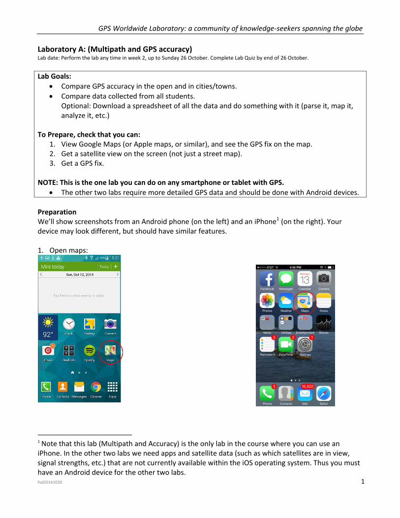
Preparation We’ll show screenshots from an Android phone (on the left) and an iPhone1 (on the right). Your device may look different, but should have similar features. 1. Open maps:
1 Note that this lab (Multipath and Accuracy) is the only lab in the course where you can use an
iPhone. In the other two labs we need apps and satellite data (such as which satellites are in view, signal strengths, etc.) that are not currently available within the iOS operating system. Thus you must have an Android device for the other two labs.
GPS Worldwide Laboratory: a community of knowledge-seekers spanning the globe
fvd20141020 2
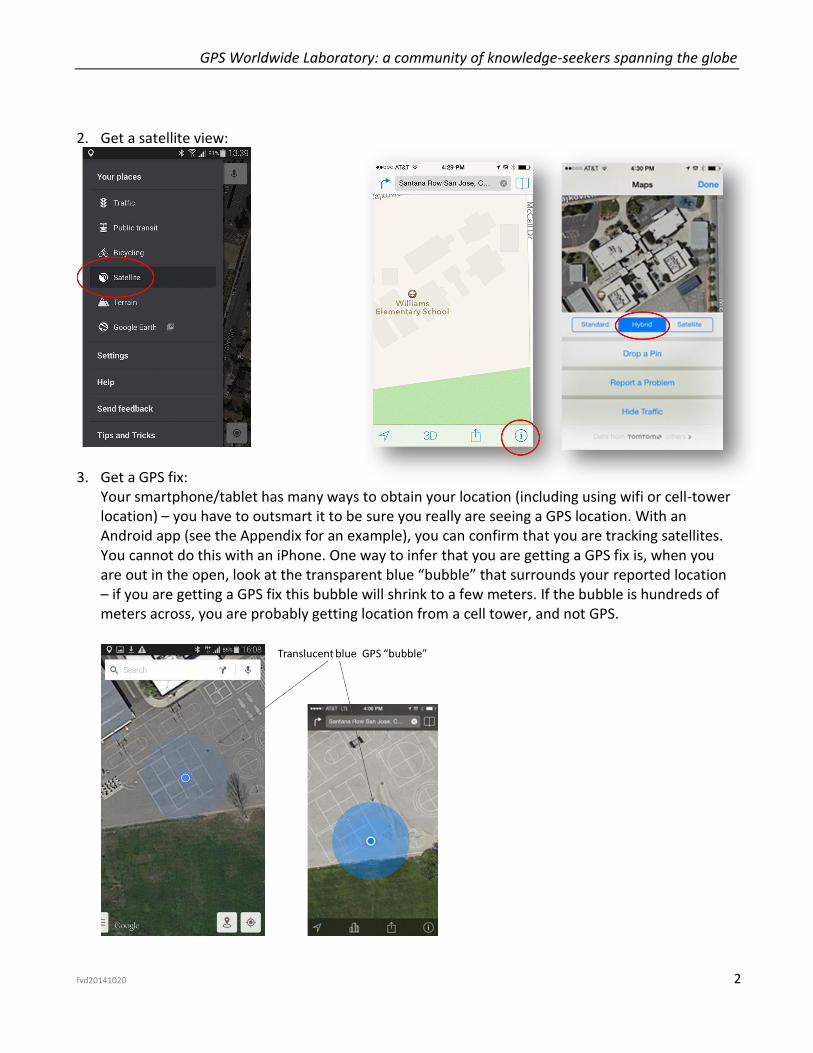
2. Get a satellite view:
3. Get a GPS fix:
Your smartphone/tablet has many ways to obtain your location (including using wifi or cell-tower location) – you have to outsmart it to be sure you really are seeing a GPS location. With an Android app (see the Appendix for an example), you can confirm that you are tracking satellites. You cannot do this with an iPhone. One way to infer that you are getting a GPS fix is, when you are out in the open, look at the transparent blue “bubble” that surrounds your reported location – if you are getting a GPS fix this bubble will shrink to a few meters. If the bubble is hundreds of meters across, you are probably getting location from a cell tower, and not GPS.
GPS Worldwide Laboratory: a community of knowledge-seekers spanning the globe
fvd20141020 3
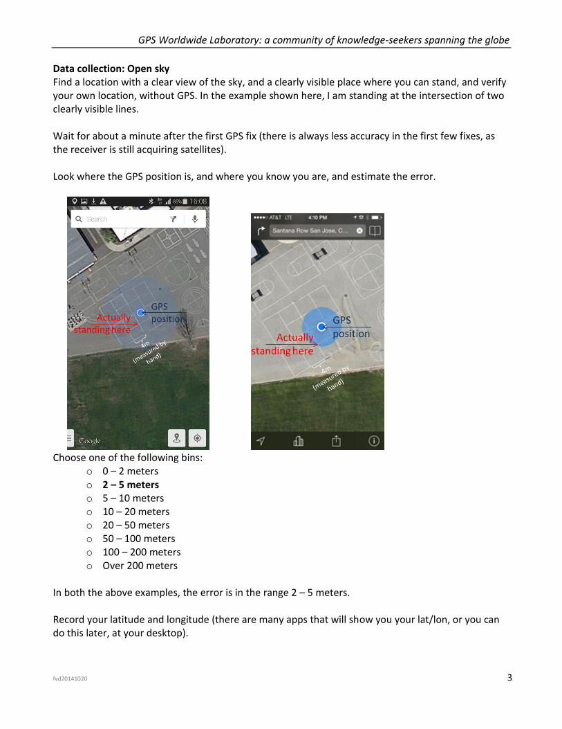
Data collection: Open sky Find a location with a clear view of the sky, and a clearly visible place where you can stand, and verify your own location, without GPS. In the example shown here, I am standing at the intersection of two clearly visible lines. Wait for about a minute after the first GPS fix (there is always less accuracy in the first few fixes, as the receiver is still acquiring satellites). Look where the GPS position is, and where you know you are, and estimate the error.
Choose one of the following bins:
o 0 – 2 meters o 2 – 5 meters o 5 – 10 meters o 10 – 20 meters o 20 – 50 meters o 50 – 100 meters o 100 – 200 meters o Over 200 meters
In both the above examples, the error is in the range 2 – 5 meters. Record your latitude and longitude (there are many apps that will show you your lat/lon, or you can do this later, at your desktop).
GPS Worldwide Laboratory: a community of knowledge-seekers spanning the globe
fvd20141020 4
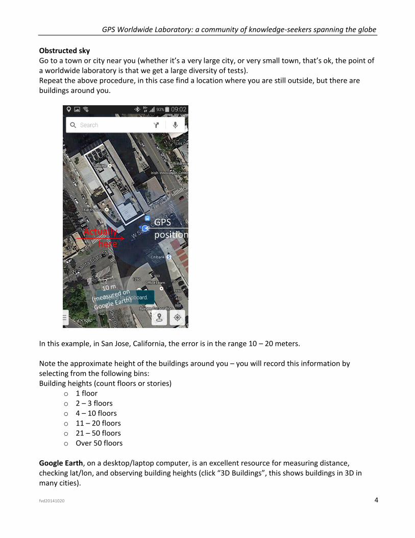
Obstructed sky Go to a town or city near you (whether it’s a very large city, or very small town, that’s ok, the point of a worldwide laboratory is that we get a large diversity of tests). Repeat the above procedure, in this case find a location where you are still outside, but there are buildings around you.
In this example, in San Jose, California, the error is in the range 10 – 20 meters. Note the approximate height of the buildings around you – you will record this information by selecting from the following bins: Building heights (count floors or stories)
o 1 floor o 2 – 3 floors o 4 – 10 floors o 11 – 20 floors o 21 – 50 floors o Over 50 floors
Google Earth, on a desktop/laptop computer, is an excellent resource for measuring distance, checking lat/lon, and observing building heights (click “3D Buildings”, this shows buildings in 3D in many cities).
GPS Worldwide Laboratory: a community of knowledge-seekers spanning the globe
fvd20141020 5
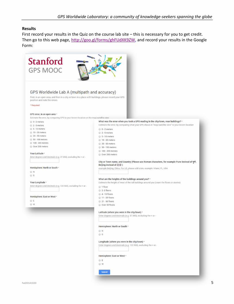
Results First record your results in the Quiz on the course lab site – this is necessary for you to get credit. Then go to this web page, http://goo.gl/forms/ghFUdXK9ZW, and record your results in the Google Form:
GPS Worldwide Laboratory: a community of knowledge-seekers spanning the globe
fvd20141020 6
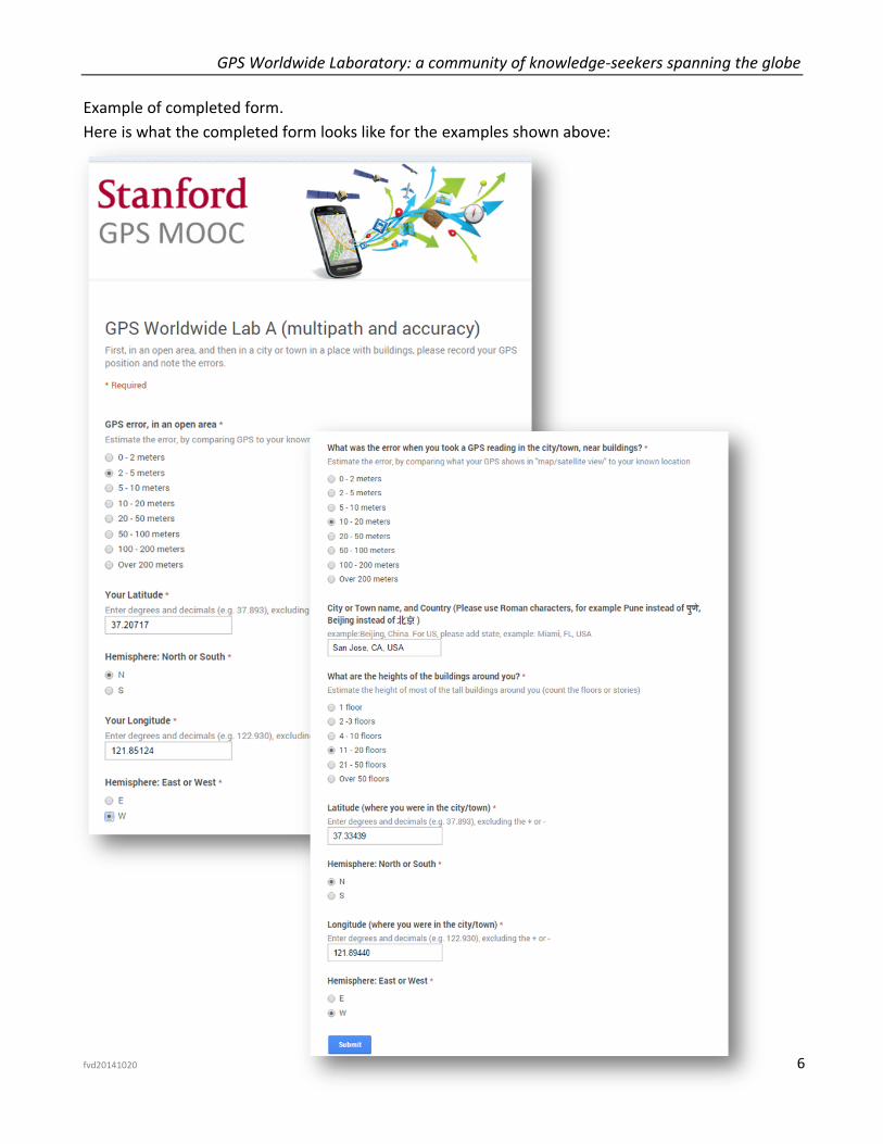
Example of completed form.
Here is what the completed form looks like for the examples shown above:
GPS Worldwide Laboratory: a community of knowledge-seekers spanning the globe
fvd20141020 7
Analysis of completed lab results
This is your opportunity to be part of something unprecedented. There are over twenty thousand people
registered for this course. As far as we know, no one has ever collected data from so many people analyzing
GPS accuracy and multipath. If you each enter your data on the online form you may be part of the largest
group ever to participate in this kind of experiment. In any case, we will collect all the data and make it
available to all of you as a csv (comma separated variable) file**. You are then free to do with it whatever you
like – analyze the statistics, plot histograms, plot a heatmap, write a conference paper, submit an entry to the
Guinness Book of World Records, etc.
You can share your work with the class by posting your analysis, pictures, powerpoints, etc. on the lab site:
www.gps-lab.org/labs.html
** Please note: the data collected in the Google form and in the csv file is anonymous; your identity is neither
collected nor available to anyone.
GPS Worldwide Laboratory: a community of knowledge-seekers spanning the globe
fvd20141020 8
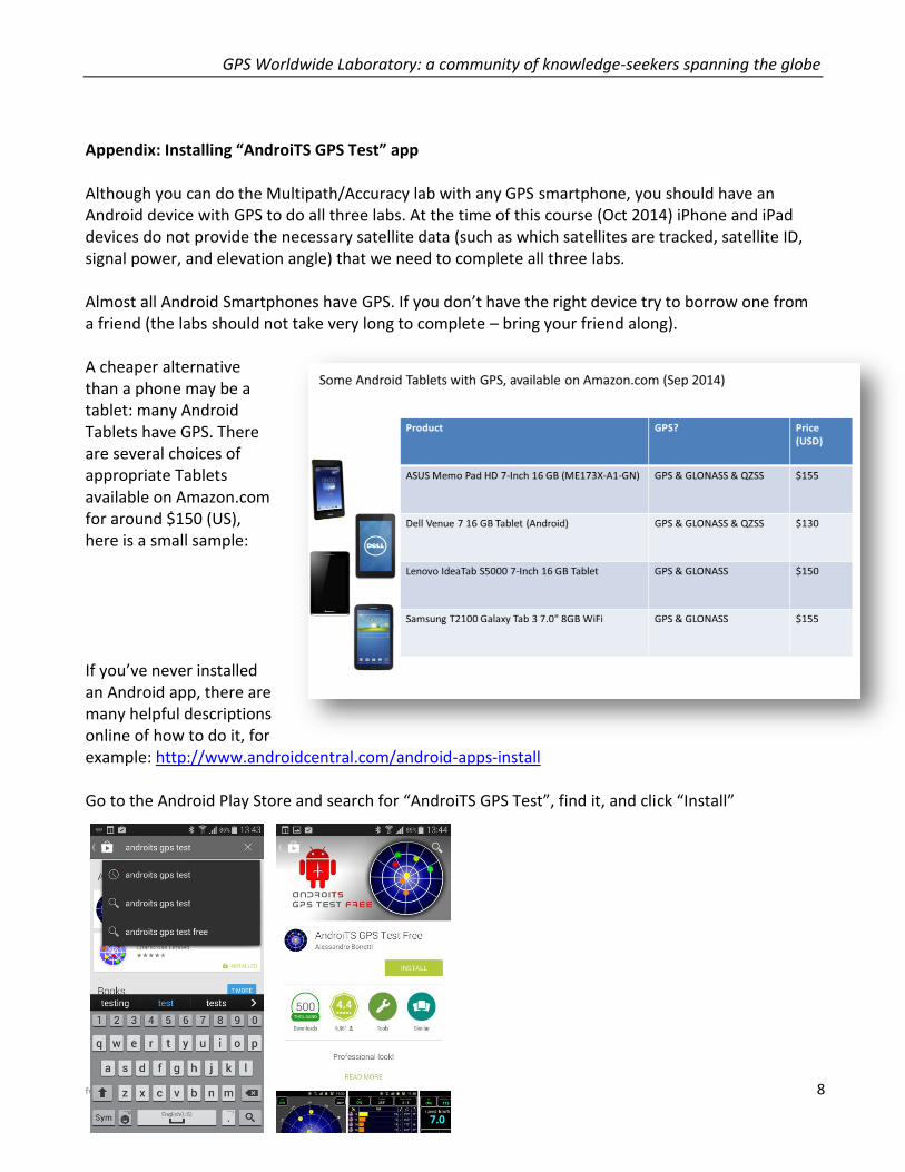
Appendix: Installing “AndroiTS GPS Test” app Although you can do the Multipath/Accuracy lab with any GPS smartphone, you should have an Android device with GPS to do all three labs. At the time of this course (Oct 2014) iPhone and iPad devices do not provide the necessary satellite data (such as which satellites are tracked, satellite ID, signal power, and elevation angle) that we need to complete all three labs. Almost all Android Smartphones have GPS. If you don’t have the right device try to borrow one from a friend (the labs should not take very long to complete – bring your friend along). A cheaper alternative than a phone may be a tablet: many Android Tablets have GPS. There are several choices of appropriate Tablets available on Amazon.com for around $150 (US), here is a small sample: If you’ve never installed an Android app, there are many helpful descriptions online of how to do it, for example: http://www.androidcentral.com/android-apps-install Go to the Android Play Store and search for “AndroiTS GPS Test”, find it, and click “Install”
GPS Worldwide Laboratory: a community of knowledge-seekers spanning the globe
fvd20141020 9
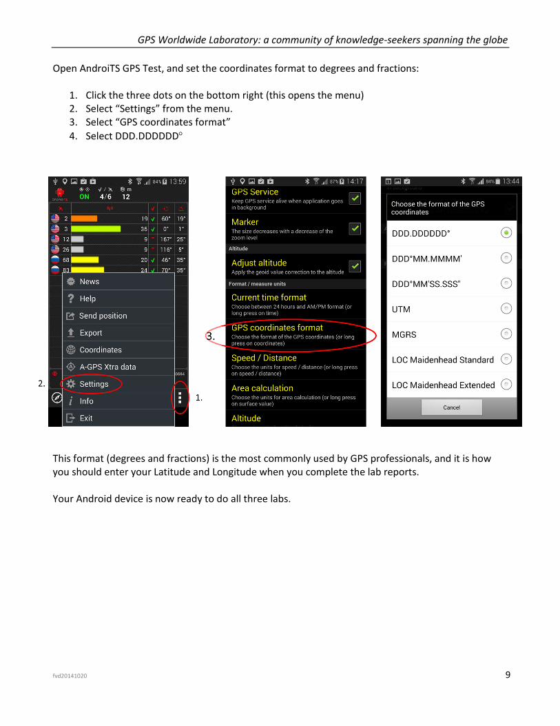
Open AndroiTS GPS Test, and set the coordinates format to degrees and fractions:
1. Click the three dots on the bottom right (this opens the menu) 2. Select “Settings” from the menu. 3. Select “GPS coordinates format”
4. Select DDD.DDDDDD
This format (degrees and fractions) is the most commonly used by GPS professionals, and it is how you should enter your Latitude and Longitude when you complete the lab reports. Your Android device is now ready to do all three labs.