Embed Size (px)
Citation preview
LaConner Bike Maps
LaConner Bike Maps On and off-road bike routes in LaConner, West Skagit County, and with Regional Bike Trails
June 2011
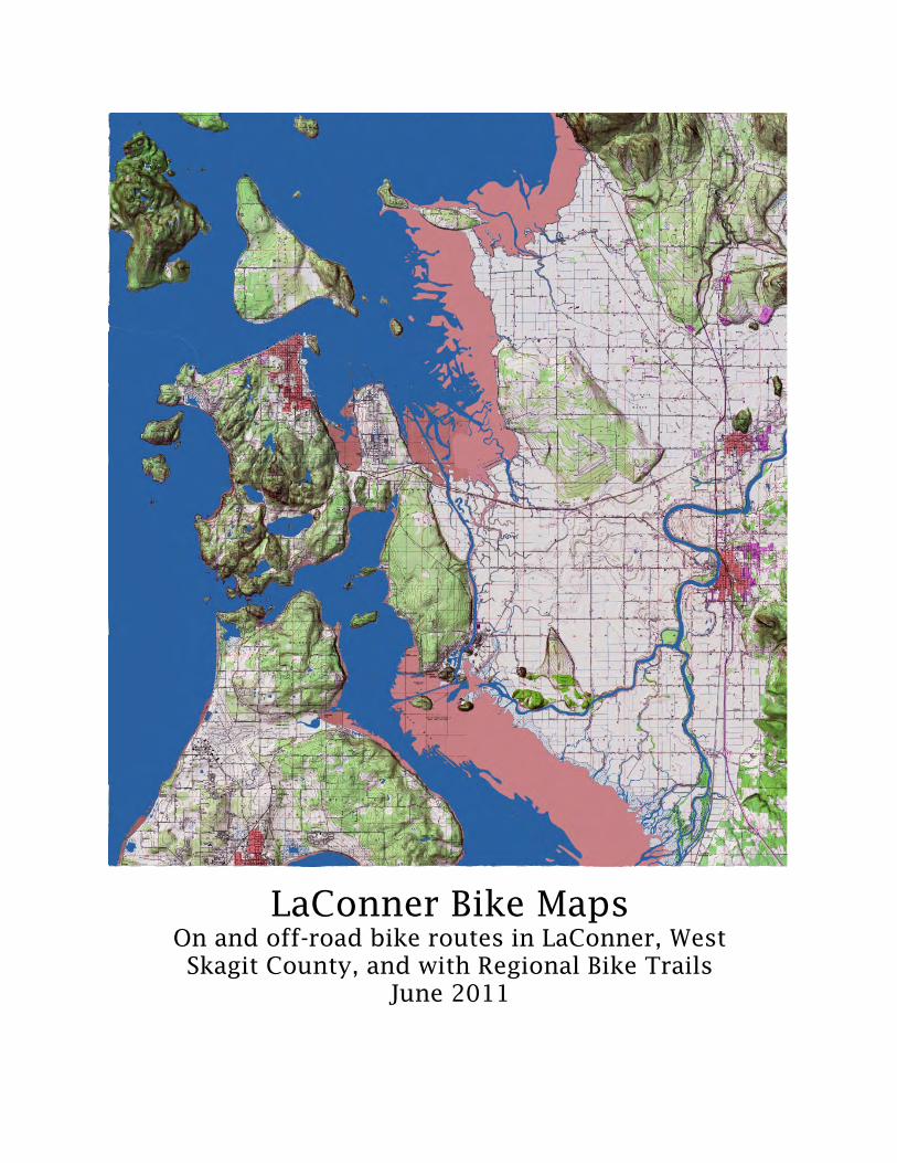
The Channel Lodge Waterfront boutique hotel with 24 rooms featuring private balconies, gas
fireplaces, Jacuzzi bathtubs, spa services, continental breakfast, business center, conference room, and evening music and wine bar in the lobby. Transient boat dock adjoins the waterfront landing for hotel guests and visitors. PO Box 573, LaConner, WA 98257 888-466-4113, 360-466-3101 www.laconnerlodging.com [email protected]
LaConner Country Inn Downtown boutique hotel with 28 rooms providing gas fireplaces, Jacuzzi bathtubs, continental
breakfast, spa services, business center, conference and 40-70 person meeting room facilities including breakout rooms, and adjoining bar and restaurant (Nell Thorne). PO Box 573, LaConner, WA 98257 888-466-4113, 360-466-3101 www.laconnerlodging.com [email protected]
Hotel Planter Historic downtown hotel listed on the National Register with 12 custom furnished guest rooms, private courtyard, gazebo, and covered hot tub.
715 South First Street, LaConner, WA 98257 360-466-4710, 800-488-5409 www.hotelplanter.com [email protected]
The Wild Iris Inn Luxury 18 room bed and breakfast inn with jetted spa tubs,
fireplaces, and private decks or balconies, continental breakfast, located blocks from the historic downtown. Ranked #1 Bed and Breakfast in LaConner by TripAdvisor Members. 121 Maple Avenue, LaConner, WA 98257 800-477-1400, 360-466-1400 www.wildiris.com [email protected]
The Heron Inn & Day Spa Elegant French Country style dog-friendly, bed and breakfast inn with Craftsman
Style furnishings, fireplaces, Jacuzzi, full service day spa staffed with massage therapists and estheticians, continental breakfast, located blocks from the historic downtown. 117 Maple Avenue, LaConner, WA 98257 360-399-1074 www.theheroninn.com [email protected]
Katy’s Inn Historic building converted into cozy 4 room bed and breakfast with private baths, wrap-around porch with views, patio, hot tub, continental
breakfast, and cookies and milk at bedtime, located a block from the historic downtown. 503 South Third Street, LaConner, WA 98257 360-466-9909, 866-katysinn www.katysinn.com [email protected]
Queen of the Valley Inn Century old farmhouse converted into 4 room bed and breakfast decorated in
Africa, West Indies, and Hong Kong styles with private bathrooms, Jacuzzi or soaking tubs, outdoor hot tub, and continental breakfast served on glassed in porch located in farmland minutes from downtown LaConner. 12757 Chilberg Road, LaConner, WA 98257 888-999-1404, 360-466-4578 www.queenofthevalleyinn.com [email protected]
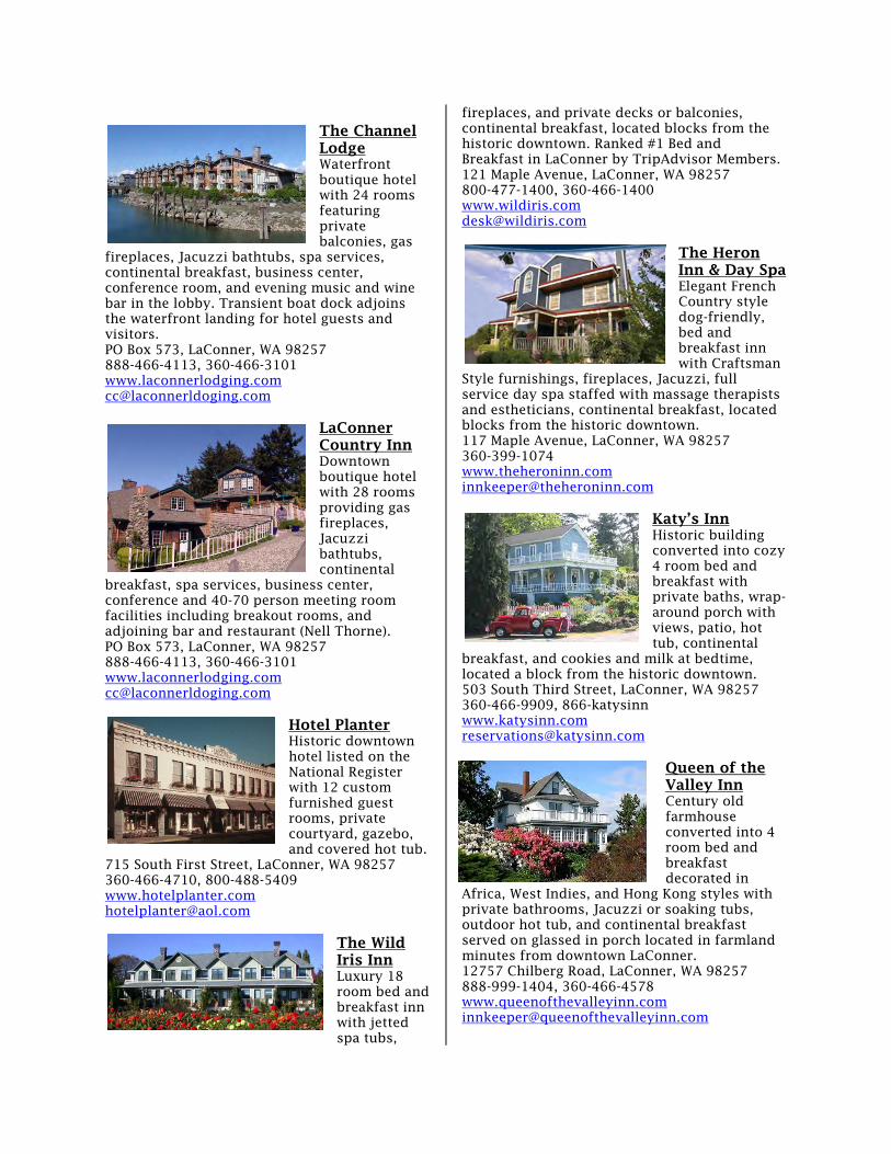
LaConner Bike Map Boardwalks/piers Museums Public restrooms
School playfields
Town fields
Swadab Park
Pioneer Park
Pearl Jensen Way
3rd
St
1st
St
6th
St
State St
Road St AArrtt
HHiissttoorryy
QQuuiilltt
to Shelter Bay
Douglas
Caledonia
Wh
atc
om
St
4th
St
Sherman
4th
St
Map
le
Pio
neer
Pkw
y
Fro
nt
St
to McGlinn Island Way B
Morris St
Basin Rd
PPaarrkkiinngg
PPaarrkkiinngg
Washington St
Benton
2 LaConner Bike Map
LaConner Bike Map
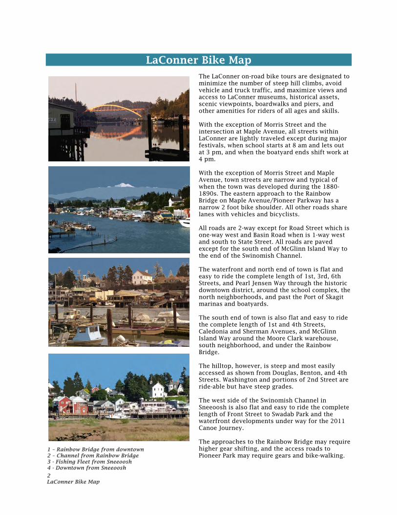
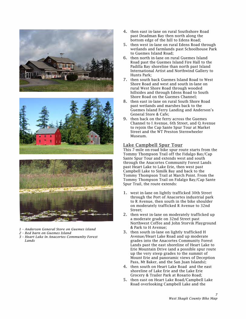
The LaConner on-road bike tours are designated to minimize the number of steep hill climbs, avoid vehicle and truck traffic, and maximize views and access to LaConner museums, historical assets, scenic viewpoints, boardwalks and piers, and other amenities for riders of all ages and skills. With the exception of Morris Street and the intersection at Maple Avenue, all streets within LaConner are lightly traveled except during major festivals, when school starts at 8 am and lets out at 3 pm, and when the boatyard ends shift work at 4 pm. With the exception of Morris Street and Maple Avenue, town streets are narrow and typical of when the town was developed during the 1880-1890s. The eastern approach to the Rainbow Bridge on Maple Avenue/Pioneer Parkway has a narrow 2 foot bike shoulder. All other roads share lanes with vehicles and bicyclists. All roads are 2-way except for Road Street which is one-way west and Basin Road when is 1-way west and south to State Street. All roads are paved except for the south end of McGlinn Island Way to the end of the Swinomish Channel. The waterfront and north end of town is flat and easy to ride the complete length of 1st, 3rd, 6th Streets, and Pearl Jensen Way through the historic downtown district, around the school complex, the north neighborhoods, and past the Port of Skagit marinas and boatyards. The south end of town is also flat and easy to ride the complete length of 1st and 4th Streets, Caledonia and Sherman Avenues, and McGlinn Island Way around the Moore Clark warehouse, south neighborhood, and under the Rainbow Bridge. The hilltop, however, is steep and most easily accessed as shown from Douglas, Benton, and 4th Streets. Washington and portions of 2nd Street are ride-able but have steep grades. The west side of the Swinomish Channel in Sneeoosh is also flat and easy to ride the complete length of Front Street to Swadab Park and the waterfront developments under way for the 2011 Canoe Journey. The approaches to the Rainbow Bridge may require higher gear shifting, and the access roads to Pioneer Park may require gears and bike-walking.
1 – Rainbow Bridge from downtown 2 – Channel from Rainbow Bridge 3 - Fishing Fleet from Sneeoosh 4 - Downtown from Sneeoosh
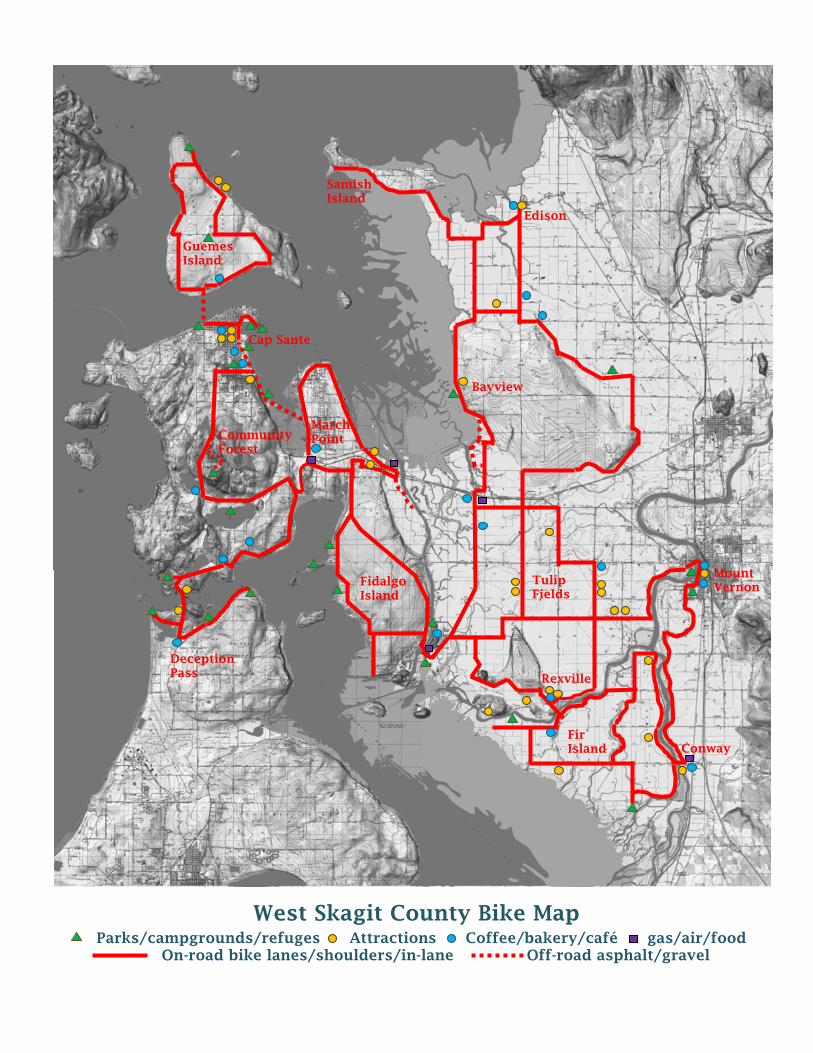
West Skagit County Bike Map Parks/campgrounds/refuges Attractions Coffee/bakery/café gas/air/food
On-road bike lanes/shoulders/in-lane Off-road asphalt/gravel
Edison
Guemes Island
Bayview
Cap Sante
March Point Community
Forest
Fidalgo Island
Tulip Fields
Samish Island
Mount Vernon
Conway Fir Island
Deception Pass Rexville
4 West Skagit County Bike Map
West Skagit County Bike Maps
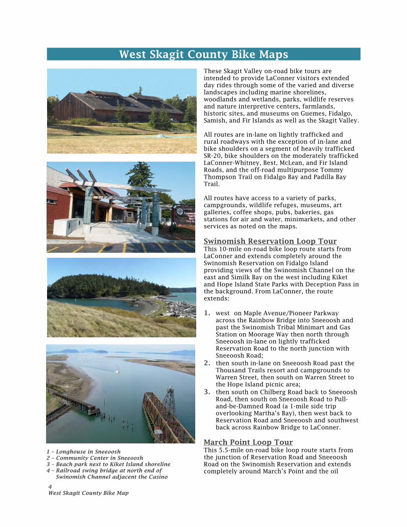
These Skagit Valley on-road bike tours are intended to provide LaConner visitors extended day rides through some of the varied and diverse landscapes including marine shorelines, woodlands and wetlands, parks, wildlife reserves and nature interpretive centers, farmlands, historic sites, and museums on Guemes, Fidalgo, Samish, and Fir Islands as well as the Skagit Valley. All routes are in-lane on lightly trafficked and rural roadways with the exception of in-lane and bike shoulders on a segment of heavily trafficked SR-20, bike shoulders on the moderately trafficked LaConner-Whitney, Best, McLean, and Fir Island Roads, and the off-road multipurpose Tommy Thompson Trail on Fidalgo Bay and Padilla Bay Trail. All routes have access to a variety of parks, campgrounds, wildlife refuges, museums, art galleries, coffee shops, pubs, bakeries, gas stations for air and water, minimarkets, and other services as noted on the maps. Swinomish Reservation Loop Tour This 10-mile on-road bike loop route starts from LaConner and extends completely around the Swinomish Reservation on Fidalgo Island providing views of the Swinomish Channel on the east and Similk Bay on the west including Kiket and Hope Island State Parks with Deception Pass in the background. From LaConner, the route extends: 1. west on Maple Avenue/Pioneer Parkway
across the Rainbow Bridge into Sneeoosh and past the Swinomish Tribal Minimart and Gas Station on Moorage Way then north through Sneeoosh in-lane on lightly trafficked Reservation Road to the north junction with Sneeoosh Road;
2. then south in-lane on Sneeoosh Road past the Thousand Trails resort and campgrounds to Warren Street, then south on Warren Street to the Hope Island picnic area;
3. then south on Chilberg Road back to Sneeoosh Road, then south on Sneeoosh Road to Pull-and-be-Damned Road (a 1-mile side trip overlooking Martha’s Bay), then west back to Reservation Road and Sneeoosh and southwest back across Rainbow Bridge to LaConner.
March Point Loop Tour This 5.5-mile on-road bike loop route starts from the junction of Reservation Road and Sneeoosh Road on the Swinomish Reservation and extends completely around March’s Point and the oil
1 – Longhouse in Sneeoosh 2 – Community Center in Sneeoosh 3 – Beach park next to Kiket Island shoreline 4 – Railroad swing bridge at north end of
Swinomish Channel adjacent the Casino
5 West Skagit County Bike Map
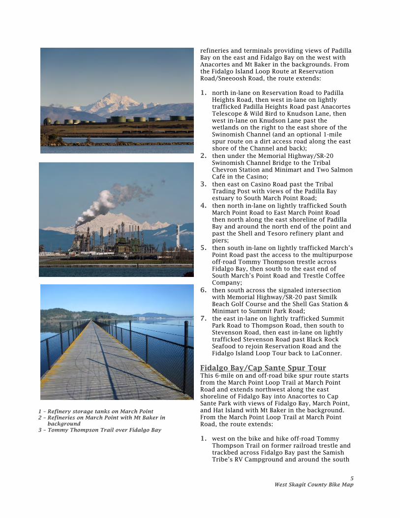
refineries and terminals providing views of Padilla Bay on the east and Fidalgo Bay on the west with Anacortes and Mt Baker in the backgrounds. From the Fidalgo Island Loop Route at Reservation Road/Sneeoosh Road, the route extends: 1. north in-lane on Reservation Road to Padilla
Heights Road, then west in-lane on lightly trafficked Padilla Heights Road past Anacortes Telescope & Wild Bird to Knudson Lane, then west in-lane on Knudson Lane past the wetlands on the right to the east shore of the Swinomish Channel (and an optional 1-mile spur route on a dirt access road along the east shore of the Channel and back);
2. then under the Memorial Highway/SR-20 Swinomish Channel Bridge to the Tribal Chevron Station and Minimart and Two Salmon Café in the Casino;
3. then east on Casino Road past the Tribal Trading Post with views of the Padilla Bay estuary to South March Point Road;
4. then north in-lane on lightly trafficked South March Point Road to East March Point Road then north along the east shoreline of Padilla Bay and around the north end of the point and past the Shell and Tesoro refinery plant and piers;
5. then south in-lane on lightly trafficked March’s Point Road past the access to the multipurpose off-road Tommy Thompson trestle across Fidalgo Bay, then south to the east end of South March’s Point Road and Trestle Coffee Company;
6. then south across the signaled intersection with Memorial Highway/SR-20 past Similk Beach Golf Course and the Shell Gas Station & Minimart to Summit Park Road;
7. the east in-lane on lightly trafficked Summit Park Road to Thompson Road, then south to Stevenson Road, then east in-lane on lightly trafficked Stevenson Road past Black Rock Seafood to rejoin Reservation Road and the Fidalgo Island Loop Tour back to LaConner.
Fidalgo Bay/Cap Sante Spur Tour This 6-mile on and off-road bike spur route starts from the March Point Loop Trail at March Point Road and extends northwest along the east shoreline of Fidalgo Bay into Anacortes to Cap Sante Park with views of Fidalgo Bay, March Point, and Hat Island with Mt Baker in the background. From the March Point Loop Trail at March Point Road, the route extends: 1. west on the bike and hike off-road Tommy
Thompson Trail on former railroad trestle and trackbed across Fidalgo Bay past the Samish Tribe’s RV Campground and around the south
1 – Refinery storage tanks on March Point 2 – Refineries on March Point with Mt Baker in
background 3 – Tommy Thompson Trail over Fidalgo Bay
6 West Skagit County Bike Map
end of the Bay to the Port of Anacortes industrial park;
2. then north on Tommy Thompson off-road trail and across T Avenue and past the Pacific Marine Center;
3. then continuing north of the off-road Tommy Thompson Trail or on-road in-lane on moderately trafficked R/Q Avenue past Strawberry Bay Coffee and the Safeway and The Market grocery stores with Starbucks;
4. then north on R/Q Avenue to Seafarer’s Way and a possible side trip east on Seafarer’s Way to Seafarer’s Memorial Park on the Fidalgo Bay shoreline;
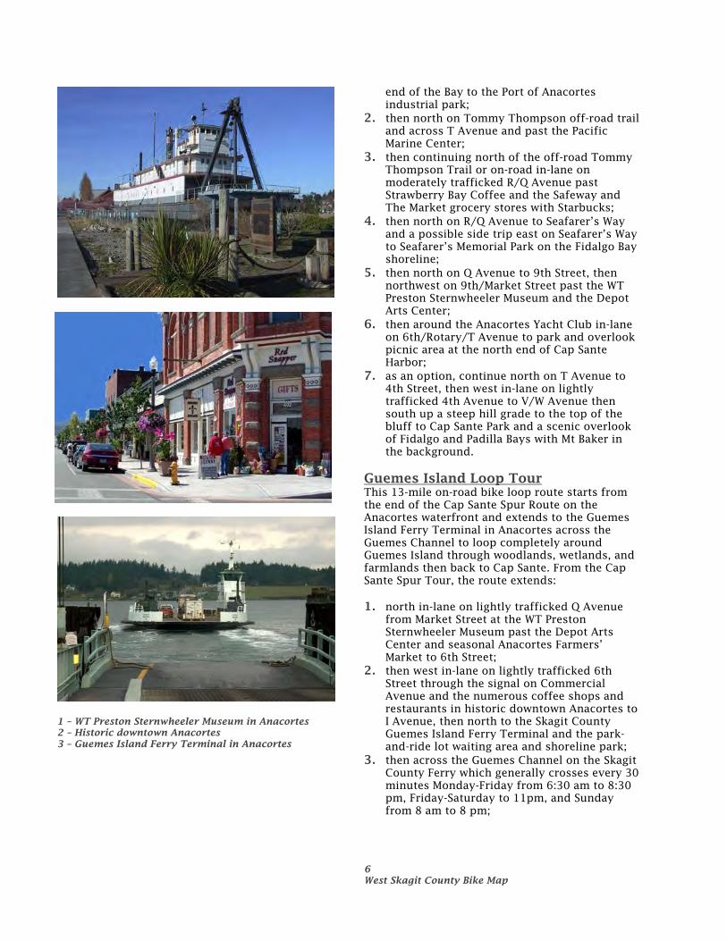
5. then north on Q Avenue to 9th Street, then northwest on 9th/Market Street past the WT Preston Sternwheeler Museum and the Depot Arts Center;
6. then around the Anacortes Yacht Club in-lane on 6th/Rotary/T Avenue to park and overlook picnic area at the north end of Cap Sante Harbor;
7. as an option, continue north on T Avenue to 4th Street, then west in-lane on lightly trafficked 4th Avenue to V/W Avenue then south up a steep hill grade to the top of the bluff to Cap Sante Park and a scenic overlook of Fidalgo and Padilla Bays with Mt Baker in the background.
Guemes Island Loop Tour This 13-mile on-road bike loop route starts from the end of the Cap Sante Spur Route on the Anacortes waterfront and extends to the Guemes Island Ferry Terminal in Anacortes across the Guemes Channel to loop completely around Guemes Island through woodlands, wetlands, and farmlands then back to Cap Sante. From the Cap Sante Spur Tour, the route extends: 1. north in-lane on lightly trafficked Q Avenue
from Market Street at the WT Preston Sternwheeler Museum past the Depot Arts Center and seasonal Anacortes Farmers’ Market to 6th Street;
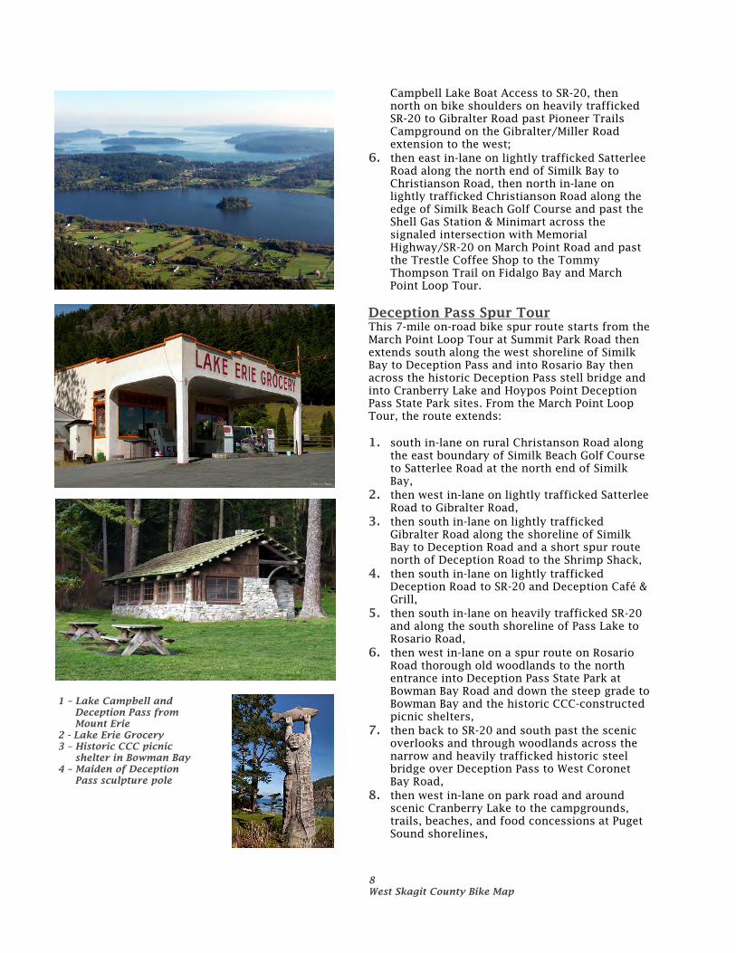
2. then west in-lane on lightly trafficked 6th Street through the signal on Commercial Avenue and the numerous coffee shops and restaurants in historic downtown Anacortes to I Avenue, then north to the Skagit County Guemes Island Ferry Terminal and the park-and-ride lot waiting area and shoreline park;
3. then across the Guemes Channel on the Skagit County Ferry which generally crosses every 30 minutes Monday-Friday from 6:30 am to 8:30 pm, Friday-Saturday to 11pm, and Sunday from 8 am to 8 pm;
1 – WT Preston Sternwheeler Museum in Anacortes 2 – Historic downtown Anacortes 3 – Guemes Island Ferry Terminal in Anacortes
7 West Skagit County Bike Map
4. then east in-lane on rural Southshore Road past Deadman Bay then north along the bottom edge of the hill to Edens Road;
5. then west in-lane on rural Edens Road through wetlands and farmlands past Schoolhouse Park to Guemes Island Road;
6. then north in-lane on rural Guemes Island Road past the Guemes Island Fire Hall to the Padilla Bay shoreline than north past Island International Artist and Northwind Gallery to Hunts Park;
7. then south back Guemes Island Road to West Shore Road and west and south in-lane on rural West Shore Road through wooded hillsides and through Edens Road to South Shore Road on the Guemes Channel;
8. then east in-lane on rural South Shore Road past wetlands and marshes back to the Guemes Island Ferry Landing and Anderson’s General Store & Cafe;
9. then back on the ferry across the Guemes Channel to I Avenue, 6th Street, and Q Avenue to rejoin the Cap Sante Spur Tour at Market Street and the WT Preston Sternwheeler Museum.
Lake Campbell Spur Tour This 7-mile on-road bike spur route starts from the Tommy Thompson Trail off the Fidalgo Bay/Cap Sante Spur Tour and extends west and south through the Anacortes Community Forest Lands past Heart Lake to Lake Erie, then west past Campbell Lake to Similk Bay and back to the Tommy Thompson Trail at March Point. From the Tommy Thompson Trail on Fidalgo Bay/Cap Sante Spur Trail, the route extends: 1. west in-lane on lightly trafficked 30th Street
through the Port of Anacortes industrial park to R Avenue, then south in the bike shoulder on moderately trafficked R Avenue to 32nd Street;
2. then west in-lane on moderately trafficked up a moderate grade on 32nd Street past Northwest Coffee and John Storvik Playground & Park to H Avenue;
3. then south in-lane on lightly trafficked H Avenue/Heart Lake Road and up moderate grades into the Anacortes Community Forest Lands past the east shoreline of Heart Lake to Erie Mountain Drive (and a possible spur route up the very steep grades to the summit of Mount Erie and panoramic views of Deception Pass, Mt Baker, and the San Juan Islands);
4. then south on Heart Lake Road and the east shoreline of Lake Erie and the Lake Erie Grocery & Trailer Park at Rosario Road;
5. then east on Heart Lake Road/Campbell Lake Road overlooking Campbell Lake and the
1 – Anderson General Store on Guemes island 2 – Red barn on Guemes Island 3 – Heart Lake in Anacortes Community Forest
Lands
8 West Skagit County Bike Map
Campbell Lake Boat Access to SR-20, then north on bike shoulders on heavily trafficked SR-20 to Gibralter Road past Pioneer Trails Campground on the Gibralter/Miller Road extension to the west;
6. then east in-lane on lightly trafficked Satterlee Road along the north end of Similk Bay to Christianson Road, then north in-lane on lightly trafficked Christianson Road along the edge of Similk Beach Golf Course and past the Shell Gas Station & Minimart across the signaled intersection with Memorial Highway/SR-20 on March Point Road and past the Trestle Coffee Shop to the Tommy Thompson Trail on Fidalgo Bay and March Point Loop Tour.
Deception Pass Spur Tour This 7-mile on-road bike spur route starts from the March Point Loop Tour at Summit Park Road then extends south along the west shoreline of Similk Bay to Deception Pass and into Rosario Bay then across the historic Deception Pass stell bridge and into Cranberry Lake and Hoypos Point Deception Pass State Park sites. From the March Point Loop Tour, the route extends: 1. south in-lane on rural Christanson Road along
the east boundary of Similk Beach Golf Course to Satterlee Road at the north end of Similk Bay,
2. then west in-lane on lightly trafficked Satterlee Road to Gibralter Road,
3. then south in-lane on lightly trafficked Gibralter Road along the shoreline of Similk Bay to Deception Road and a short spur route north of Deception Road to the Shrimp Shack,
4. then south in-lane on lightly trafficked Deception Road to SR-20 and Deception Café & Grill,
5. then south in-lane on heavily trafficked SR-20 and along the south shoreline of Pass Lake to Rosario Road,
6. then west in-lane on a spur route on Rosario Road thorough old woodlands to the north entrance into Deception Pass State Park at Bowman Bay Road and down the steep grade to Bowman Bay and the historic CCC-constructed picnic shelters,
7. then back to SR-20 and south past the scenic overlooks and through woodlands across the narrow and heavily trafficked historic steel bridge over Deception Pass to West Coronet Bay Road,
8. then west in-lane on park road and around scenic Cranberry Lake to the campgrounds, trails, beaches, and food concessions at Puget Sound shorelines,
1 – Lake Campbell and Deception Pass from Mount Erie
2 - Lake Erie Grocery 3 – Historic CCC picnic
shelter in Bowman Bay 4 – Maiden of Deception
Pass sculpture pole
9 West Skagit County Bike Map
9. then back to West Coronet Bay Road and east in-lane on park road along the south shoreline of Coronet Bay and the marinas to the end of the road at Hoypus Point overlooking Similk Bay and Hope Island State Park.
Tulip Fields Loop Tour This 14-mile on-road bike loop route starts from LaConner extends east through the heart of the seasonal (April-May) daffodil, tulip, and iris flower fields, and the year-round vineyards, corn, grain, and seed growing farm fields. From LaConner, the route extends: 1. east in-lane on lightly trafficked Chilberg Road
to Best Road, then through the stop signs across Best Road in-lane on rural Chilberg/Calhoun Road and past tulip fields to Beaver Marsh Road;
2. then north on Beaver Marsh Road past tulip fields and Roozengaarde and Washington Tulip bulb stores and plant nurseries to McLean Road and the Minimart;
3. then west on bike shoulders on moderately trafficked McLean Road past tulip fields to Bradshaw Road then north in-lane on lightly trafficked Bradshaw Road past tulip fields and Tulip Town to Young Road;
4. then west in-lane on rural Young Road past vineyards and horse farms to Best Road;
5. then south in-lane on moderately trafficked Best Road past tulip fields south through the roundabout at McLean Road and past Christenson’s Nursery and LaConner Flats A Garden and tulip fields to Chilberg Road;
6. then west on bike shoulders on Chilberg Road back to LaConner.
Rexville Loop Tour This 11-mile on-road bike loop route starts from LaConner extends east through Dodge Valley to Rexville, then east through seasonal (April-May) daffodil, tulip, and iris flower fields, and the year-round vineyards, corn, grain, and seed growing farm fields. From LaConner, the route extends: 1. east in-lane on lightly trafficked Chilberg Road
to Dodge Valley Road, then south in-lane on rural Dodge Valley Road past the Staffanson Pickle Farms to Best Road (with a short optional side spur trip south to the seasonal Art Gallery on Landing Road);
2. then south on bike shoulders on moderately trafficked Best Road to Rexville Grocery on Summers Drive;
3. then east in-lane on rural Summers Drive past the Rexville Grange and the seasonal produce market on adjacent Rexville Grange Road;
1 – Pier onto Coronet Bay in Deception Pass State Park 2 – Tulip fields from Bradshaw Road 3 – Tulip fields from Beaver Marsh Road 4 - Rexville Grocery
10 West Skagit County Bike Map
4. then east in-lane on rural Summers Drive/Daggett Road along the north levee to the north fork of the Skagit River to Beaver Marsh Road;
5. then north in-lane on rural Beaver Marsh Road past tulip fields to Calhoun/Higby Road;
6. then east in-lane on rural Calhoun/Higby Road past tulip fields to Best Road and through the stop sign on bike shoulders on Calhoun/Chilberg Road back to LaConner.
Fir Island Loop Tour This 16-mile on-road bike loop route starts from the Rexville Loop Tour at Rexville Grovery and extends through Fir Island and the farm fields and winter foraging habitat of 70-90,000 Snow Geese, Tundra and Trumpeter Swans from December to March to historic Conway. From Rexville, the route extends: 1. south in-lane on moderately trafficked Best/Fir
Island Road across the narrow North Fork Skagit River Bridge to Rawlings Road and the seasonally open Snow Goose Produce;
2. then west in-lane on rural Rawlings Road through farmlands to Blake’s RV Park & Marina and a view north across the North Fork of the Skagit River at the site of the former Fish Town art colony;
3. then east back Rawlings Road to Maupin Road and south in-lane on rural Maupin Road through farmlands to the hair curve and an overlook of the mudflats and slough;
4. then east in-lane on rural Maupin Road to Fir Island Road and the seasonally open flower stand;
5. then east on bike shoulder on moderately trafficked Fir Island Road past Snow Geese foraging fields to Wylie Road;
6. then south in-lane on rural Wylie Road to Mann Road (and a dirt spur road south to the Skagit Valley Wildlife Recreation Area);
7. then east and north in-lane on rural Mann Road through farmlands and wildlife foraging fields and along the west levee to the historic Fir-Conway Lutheran Church at Skagit City Road at the South Fork Skagit River Bridge into Conway;
8. then east in-lane on Fir Island Road across the bridge over the Skagit River to Main Street, then south and east in-lane on Main Street past Conway Muse, Conway Pub & Eatery, Pasek Cellars, Texaco and Tesoro Gas Stations in historic Conway;
9. then west back Main Street to Fir Island Road then west across the Skagit River bridge and north in-lane on rural Skagit City Road past Mother Flight Farm and the west levee of the South Fork Skagit River to the north end of
1 – Historic farmhouse on Calhoun Road 2 – Snow Goose Produce on Fir Island and Rawlings
Road 3 – Snow Geese on Fir Island 4 – Historic farmhouse on Fir Island Road
11 West Skagit County Bike Map
Skagit City Road past the historic Skagit City Schoolhouse and an overlook of the Skagit River North and South Fork divergence;
10. then west and south on Dry Slough Road through farmlands, historic farmsteads and barns, and Snow Geese foraging fields to Moore/Johnson Road (and an optional spur route continuing on Dry Sough Road to Fir Island Road);
11. then west on Moore/Johnson Road to Best Road then north across the moderately trafficked narrow South Fork Skagit River Bridge to Rexville Grocery and a rejoining of the Rexville Loop Tour.
Conway/Mount Vernon Spur Tour This 6-mile on-road bike spur route starts from historic downtown Conway off the Fir Island Loop Tour and extends north through farmlands and along the east levee to the Skagit River into historic downtown Mount Vernon. From Conway, the route extends: 1. west and north in-lane on Main Street from the
Texaco and Tesoro Gas Stations, Pasek Cellars, Conway Pub & Eatery, and the Conway Muse to Fir Island Road, then north across Fir Island Road in-lane on rural Greenfield Street/Dike Road next to the east levee to the Skagit River past farmlands and historic farmsteads to Britt Road;
2. then east and north in-lane on rural Britt Road along Britt Slough and wetlands to Britt Road/Hazel Street to Cleveland Avenue and the Mount Vernon Senior Center;
3. then north in-lane on moderately trafficked Cleveland Avenue/1st Street past Sigi’s Cinnamons through historic downtown Mount Vernon to the Skagit Valley Food Coop at Division Street.
Mount Vernon/LaConner Spur Tour This 9-mile on-road bike spur route starts from historic downtown Mount Vernon at the end of the Conway/Mount Vernon Spur Tour and extends west through farmlands and tulip fields to LaConner. From historic downtown Mount Vernon, the route extends: 1. west from the Skagit Valley Food Coop in-lane
on heavily trafficked Division Street across the narrow Skagit River Bridge to Ball Street at Edgewater Park;
2. then south through Edgewater Park on Ball/Baker Street/Behrens Millett Road on and adjacent to the west levee to the Skagit River past river shoreline and wetlands on Behrens Millett/Penn Road to Calhoun Road at the access to the top of the levee;
1 – Barn on Fir Island Road 2 – Historic Conway Main Street 3 – Historic downtown Mount Vernon 4 – Levee Trail on Mount Vernon waterfront
12 West Skagit County Bike Map
3. then west in-lane on rural Calhoun/Higby Road past historic farm houses, dairy farms, tulip fields, Ralph’s and Jonkeer Greenhouses across Daggett/Beaver Marsh Road to the stop sign at Best Road and the Tulip Field Loop Tour;
4. then west on bike shoulders on Calhoun/Chilberg Road on the Tulip Field Loop Tour back to LaConner.
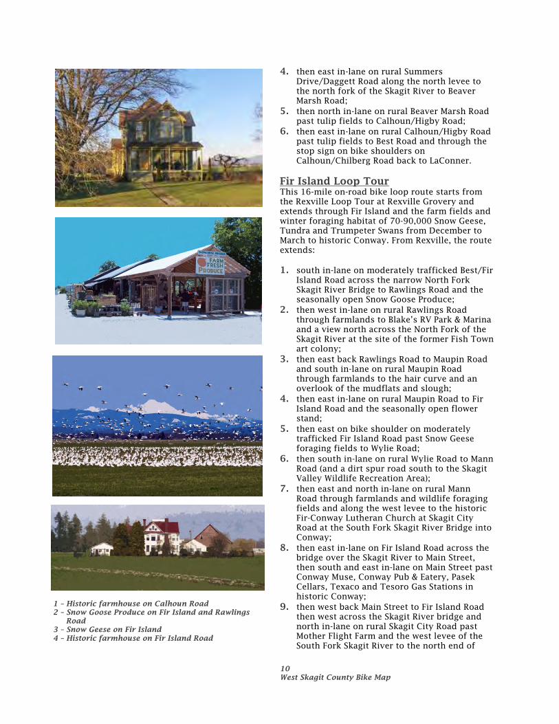
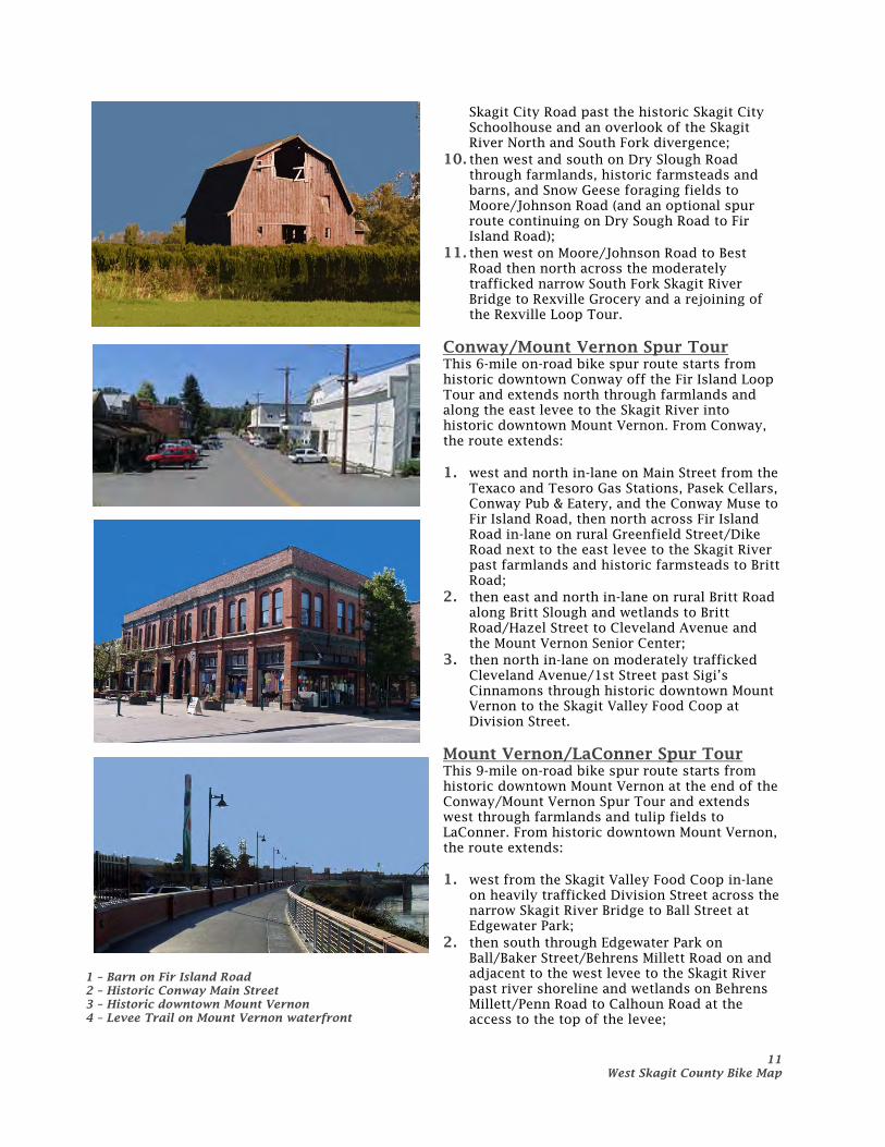
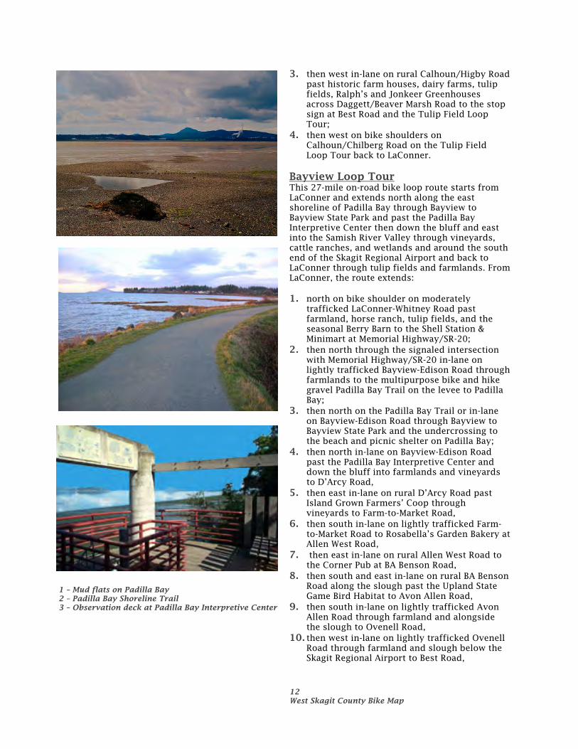
Bayview Loop Tour This 27-mile on-road bike loop route starts from LaConner and extends north along the east shoreline of Padilla Bay through Bayview to Bayview State Park and past the Padilla Bay Interpretive Center then down the bluff and east into the Samish River Valley through vineyards, cattle ranches, and wetlands and around the south end of the Skagit Regional Airport and back to LaConner through tulip fields and farmlands. From LaConner, the route extends: 1. north on bike shoulder on moderately
trafficked LaConner-Whitney Road past farmland, horse ranch, tulip fields, and the seasonal Berry Barn to the Shell Station & Minimart at Memorial Highway/SR-20;
2. then north through the signaled intersection with Memorial Highway/SR-20 in-lane on lightly trafficked Bayview-Edison Road through farmlands to the multipurpose bike and hike gravel Padilla Bay Trail on the levee to Padilla Bay;
3. then north on the Padilla Bay Trail or in-lane on Bayview-Edison Road through Bayview to Bayview State Park and the undercrossing to the beach and picnic shelter on Padilla Bay;
4. then north in-lane on Bayview-Edison Road past the Padilla Bay Interpretive Center and down the bluff into farmlands and vineyards to D’Arcy Road,
5. then east in-lane on rural D’Arcy Road past Island Grown Farmers’ Coop through vineyards to Farm-to-Market Road,
6. then south in-lane on lightly trafficked Farm-to-Market Road to Rosabella’s Garden Bakery at Allen West Road,
7. then east in-lane on rural Allen West Road to the Corner Pub at BA Benson Road,
8. then south and east in-lane on rural BA Benson Road along the slough past the Upland State Game Bird Habitat to Avon Allen Road,
9. then south in-lane on lightly trafficked Avon Allen Road through farmland and alongside the slough to Ovenell Road,
10. then west in-lane on lightly trafficked Ovenell Road through farmland and slough below the Skagit Regional Airport to Best Road,
1 – Mud flats on Padilla Bay 2 – Padilla Bay Shoreline Trail 3 – Observation deck at Padilla Bay Interpretive Center
13 West Skagit County Bike Map
11. then south on Best Road and through the signaled intersection with Memorial Highway/SR-20 to Young Road,
12. then west in-lane on rural Young Road past vineyards and farmlands to LaConner-Whitney Road and the Shell Station & Minimart and Farmhouse Inn;
13. then south on bike shoulder on moderately trafficked LaConner-Whitney Road past the seasonal Berry Barn and evergreen hedge maze, farmlands, horse ranch, and tulip fields to LaConner.
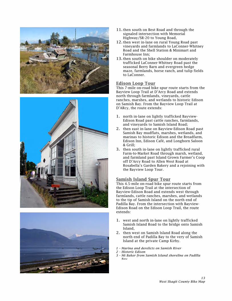
Edison Loop Tour This 7-mile on-road bike spur route starts from the Bayview Loop Trail at D’Arcy Road and extends north through farmlands, vineyards, cattle ranches, marshes, and wetlands to historic Edison on Samish Bay. From the Bayview Loop Trail at D’ARcy, the route extends: 1. north in-lane on lightly trafficked Bayview-
Edison Road past cattle ranches, farmlands, and vineyards to Samish Island Road;
2. then east in-lane on Bayview-Edison Road past Samish Bay mudflats, marshes, wetlands, and marinas to historic Edison and the Breadfarm, Edison Inn, Edison Café, and Longhorn Saloon & Grill;
3. then south in-lane on lightly trafficked rural Farm-to-Market Road through marsh, wetland, and farmland past Island Grown Farmer’s Coop off D’Arcy Road to Allen West Road at Rosabella’s Garden Bakery and a rejoining with the Bayview Loop Tour.
Samish Island Spur Tour This 4.5-mile on-road bike spur route starts from the Edison Loop Trail at the intersection of Bayview-Edison Road and extends west through farmlands, cattle ranches, marshes, and wetlands to the tip of Samish Island on the north end of Padilla Bay. From the intersection with Bayview-Edison Road on the Edison Loop Trail, the route extends: 1. west and north in-lane on lightly trafficked
Samish Island Road to the bridge onto Samish Island,
2. then west on Samish Island Road along the north end of Padilla Bay to the very of Samish Island at the private Camp Kirby.
1 – Marina and derelicts on Samish River 2 – Historic Edison 3 – Mt Baker from Samish Island shoreline on Padilla
Bay
14 West Skagit County Bike Map
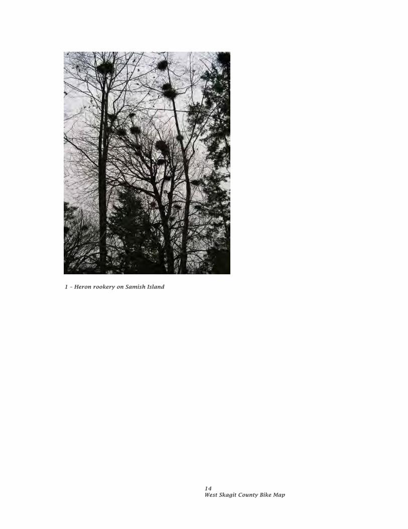
1 – Heron rookery on Samish Island
1 Regional Trails Bike Map
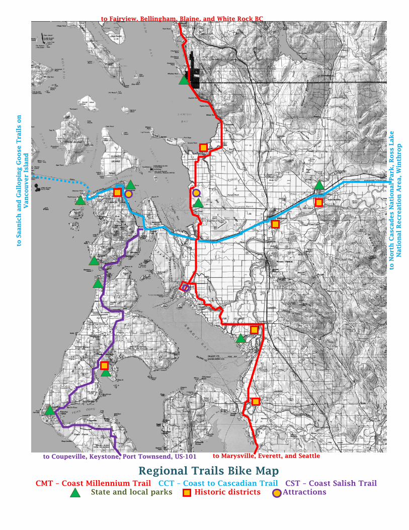
Regional Trails Bike Map CMT – Coast Millennium Trail CCT – Coast to Cascadian Trail CST – Coast Salish Trail
State and local parks Historic districts Attractions
ttoo FFaaiirrvviieeww,, BBeelllliinngghhaamm,, BBllaaiinnee,, aanndd WWhhiittee RRoocckk BBCC
ttoo MMaarryyssvviillllee,, EEvveerreetttt,, aanndd SSeeaattttllee
tt oo NN
oorr tt
hh CC
aass cc aa ddeess NN
aatt ii
oonn
aall
PPaarr kk
,, RR
ooss ss
LLaakkee
NNaatt ii
oonn
aall
RReeccrr ee
aatt ii
oonn
AArr ee
aa,, WW
ii nntt hh
rr oopp
tt oo SS
aaaann
ii cchh
aann
dd GG
aall ll
oopp
ii nngg GG
ooooss ee TT
rr aaii ll
ss oo
nn
VVaann
ccoouu
vveerr
II ssll aa
nndd
ttoo CCoouuppeevviillllee,, KKeeyyssttoonnee,, PPoorrtt TToowwnnsseenndd,, UUSS--110011
16 Regional Trails Bike Map
RReeggiioonnaall ttrraaiillss bbiikkee mmaapp
Coast Millennium Trail (CMT) This 121-mile extensive trail system in British Columbia (BC) around Boundary Bay then extends south through White Rock BC across the international boundary into Blaine and continues south through Bellingham, LaConner, Stanwood, Everett, and eventually into Seattle. From LaConner, the CMT Skagit County North segment begins at: 1. the roundabout, then north on bike shoulders
on moderately trafficked LaConner Whitney Road through farmlands to Memorial Highway/SR-20, then north in-lane on lightly trafficked Bayview-Edison Road along the east edge of Padilla Bay through Bayview State Park through the historic town of Bayview and then across farmlands to the historic town of Edison,
2. then east in-lane on lightly trafficked West Bow Hill Road to Scenic Byway SR-11/Chuckanut Drive, then north on bike shoulders through farmlands and then in-lane along the east edge of Samish Bay through Larrabee State Park to the historic town of Fairview.
Attractions along the north route in addition to the historic towns of LaConner, Bayview, Edison, and Fairview and the bakery, restaurant, coffee shops, and other amenities include: Bayview State Park and the underpass to the
picnic shelter and sandy beach on Padilla Bay, Padilla Bay Interpretive Center and the
displays and educational (including children’s hands-on exhibits) about Padilla Bay, and
Larrabee State Park and access to the extensive mountain bike and hiking trails in the Blanchard Mountain and Chuckanut Mountain Recreation Areas.
From LaConner, the CMT Skagit County South segment begins at: 1. the roundabout, then east on bike shoulders
on lightly trafficked Chilberg Road and south in-lane on lightly trafficked Dodge Valley Road through farmlands to Best Road,
2. then south on bike shoulders on moderately trafficked Best Road past Rexville Grocery and in-lane across the Skagit River Bridge past Snow Goose Fruitstand and east on bike shoulders on Fir Island Road past the Skagit State Wildlife Recreation Area and farmlands to the historic town of Conway,
3. then south on bike shoulders on moderately trafficked Pioneer Highway through farmlands to the historic town of Stanwood,
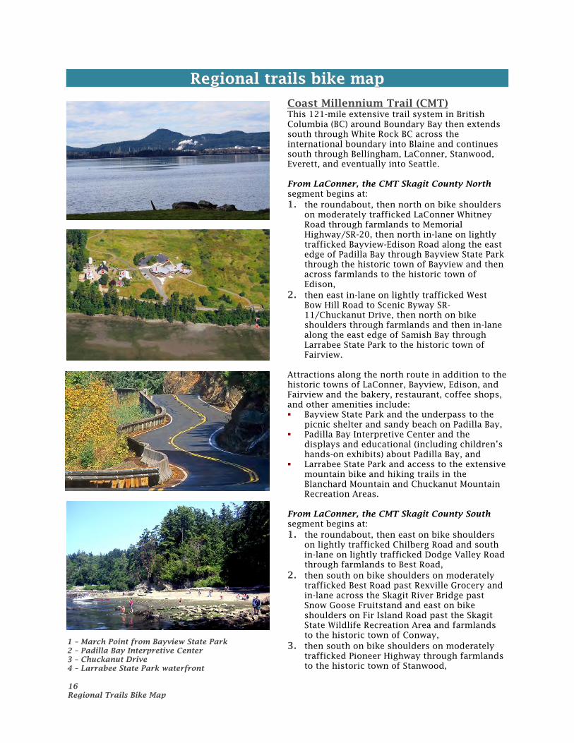
1 – March Point from Bayview State Park 2 – Padilla Bay Interpretive Center 3 – Chuckanut Drive 4 – Larrabee State Park waterfront
17 Regional Trails Bike Map
4. then south on bike shoulders on lightly trafficked Marine Drive along the east edge of Skagit Bay through the Tulalip Reservation to Marysville.
Attractions along the south route in addition to the historic towns of LaConner, Rexville, Conway, and Stanwood and the pubs, cafes, bakeries, restaurants, and coffee shops include: Rexville Grocery and the Rexville Grange
located on Best Road before the Skagit River Bridge, and
Skagit State Wildlife Recreation Area on Fir Island Road and the Snow Geese, Trumpeter and Tundra Swans during the winter months.
Coast to Cascade Trail (CCT) This 155-mile on and off-road bike route starts on Vancouver Island at the Saanich and Galloping Goose Trail then extends east on Washington State Ferries to Anacortes, then east through Burlington, Sedro-Woolley, Hamilton, and Concrete to Ross Lake National Recreation Area and eventually through the Methow Valley to Winthrop in eastern Washington. From LaConner, the CCT Skagit County West segment begins at: 1. the roundabout, then north on bike shoulders
on moderately trafficked LaConner Whitney Road through farmlands to Memorial Highway/SR-20, then west on bike shoulders on heavily trafficked SR-20 to the Swinomish Channel Bridge and the 2-way bike lanes on the north side of the bridge accessed by diversions adjacent to the Channel on both sides of the south side of the bridge,
2. then west in-lane on lightly trafficked South Point March Road to March’s Point Road, then north in-lane on lightly trafficked March’s Point Road onto the Tommy Thompson multipurpose paved trail on the old railroad trestle across Fidalgo Bay and along the west edge of Fidalgo Bay on road shoulders on moderately trafficked R Avenue through historic downtown Anacortes to 6th Street,
3. then in-lane on lightly trafficked 6th Street past the Guemes Island Ferry landing to I Avenue, then south in-lane on lightly trafficked I Avenue to 12th Street/SR-20,
4. then west on bike shoulders on heavily trafficked 12th Street/SR-20 to Ferry Terminal Road then north to the Washington State Ferry landing to the San Juan Islands and Sidney BC.
Attractions along the west route in addition to the historic towns of LaConner and Anacortes and the pubs, cafes, bakeries, restaurants, and coffee shops include:
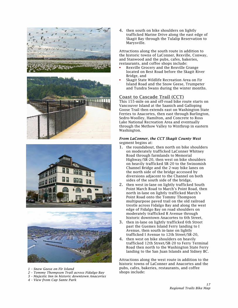
1 – Snow Geese on Fir Island 2 – Tommy Thompson Trail across Fidalgo Bay 3 – Majestic Inn in historic downtown Anacortes 4 – View from Cap Sante Park
18 Regional Trails Bike Map
Anacortes WT Preston (Sternwheeler) Museum and the Depot Arts Center on R Avenue,
the boatyards at the end of R Avenue and 6th Street on Guemes Channel,
and side trips from R Avenue east to Cap Sante Park, and Washington Park located west of the Ferry Terminal Road cutoff on the extension of Sunset Avenue from SR-20.
From LaConner, the CCT Skagit County East segment begins at: 1. the roundabout, then north on bike shoulders
on LaConner Whitney Road through farmlands to Memorial Highway/SR-20, then east on road shoulders on heavily trafficked Memorial Highway/SR-20 and through the North Burlington Road/SR-20 intersection in-lane onto lightly trafficked Rio Vista Avenue to Spruce Street, then north in-lane on lightly trafficked Spruce Street into historic downtown Burlington,
2. then east in-lane on lightly trafficked Fairhaven Avenue to Anacortes Street, then north in-lane on lightly trafficked Anacortes Street to the Cascade Highway/SR-20, then east on bike shoulders on the Cascade Highway/SR-20 to West Ferry Street,
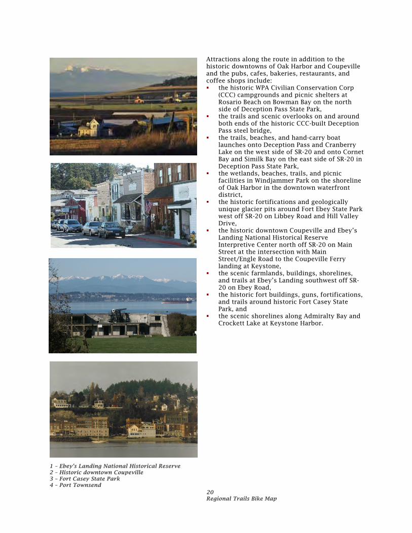
3. then east in-lane on lightly trafficked West Ferry Street through historic downtown Sedro-Woolley to Township Street, then north in-lane on lightly trafficked Township Street to East Moore Street/North Cascades Highway/SR-20 and a connection to the off-road gravel multipurpose Cascade Trail on former railroad corridor,
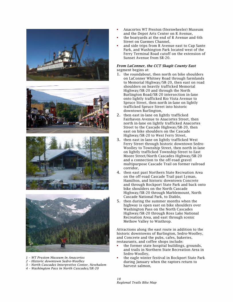
4. then east past Northern State Recreation Area on the off-road Cascade Trail past Lyman, Hamilton, and historic downtown Concrete and through Rockport State Park and back onto bike shoulders on the North Cascade Highway/SR-20 through Marblemount, North Cascade National Park, to Diablo,
5. then during the summer months when the highway is open east on bike shoulders over Washington Pass on the North Cascades Highway/SR-20 through Ross Lake National Recreation Area, and east through scenic Methow Valley to Winthrop.
Attractions along the east route in addition to the historic downtowns of Burlington, Sedro-Woolley, and Concrete and the pubs, cafes, bakeries, restaurants, and coffee shops include: the former state hospital buildings, grounds,
and trails in Northern State Recreation Area in Sedro-Woolley,
the eagle winter festival in Rockport State Park during January when the raptors return to harvest salmon,
1 – WT Preston Museum in Anacortes 2 – Historic downtown Sedro-Woolley 3 – North Cascades Interpretive Center, Newhalem 4 – Washington Pass in North Cascades/SR-20
19 Regional Trails Bike Map
the North Cascades Interpretive Center in Newhalem,
Seattle City Light historical exhibits, Diablo Lake boat tours and hillside climbs, and the North Cascades Environmental Learning Center in Diablo, and
the historical and western theme town of Winthrop.
Coast Salish Trail (CST) This 380-mile on-road bike route starts in Fidalgo Bay in Anacortes at the juncture with the Coast to Cascade Trail then extends south through Fidaldo Island and across Deception Pass onto Whidbey Island an south through Oak Harbor to Coupeville then west on Washington State Ferries to Port Townsend then west on US Highway 101 through Sequim and Port Angeles to Forks, then south on US 101 along the Washington Coast across the Columbia River to Astoria, Oregon. From LaConner, the CST Skagit County segment begins at: 1. the roundabout, then north on bike shoulders
on LaConner Whitney Road through farmlands to Memorial Highway/SR-20, then west on bike shoulders on SR-20 to the Swinomish Channel Bridge and the 2-way bike lanes on the north side of the bridge accessed by diversions adjacent to the Channel on both sides of the south side of the bridge,
2. then west in-lane on lightly trafficked South Point March Road to March’s Point Road and back onto the bike shoulder on Memorial Highway/SR-20 to the intersection of SR-20 south to Oak Harbor,
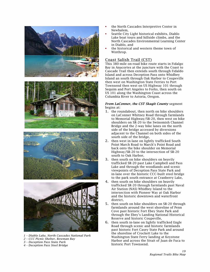
3. then south on bike shoulders on heavily trafficked SR-20 past Lake Campbell and Pass Lake and through the woodlands and scenic viewpoints of Deception Pass State Park and in-lane over the historic CCC-built steel bridge to the park south entrance at Cranberry Lake,
4. then south on bike shoulders on heavily trafficked SR-20 through farmlands past Naval Air Station (NAS) Whidbey Island to the intersection with Pioneer Way at Oak Harbor and the historic downtown and waterfront district,
5. then south on bike shoulders on SR-20 through farmlands around the west shoreline of Penn Cove past historic Fort Ebey State Park and through the Ebey’s Landing National Historical Reserve and historic Coupeville,
6. then south in-lane on lightly trafficked Engle Road through scenic and historic farmlands past historic Fort Casey State Park and around the shoreline of Crockett Lake to the Washington State Ferry landing at Keystone Harbor and across the Strait of Juan de Fuca to historic Port Townsend.
1 – Diablo Lake, North Cascades National Park 2 – CCC Picnic Shelter, Bowman Bay 3 – Deception Pass State Park 4 – Deception Pass Steel Bridge
20 Regional Trails Bike Map
Attractions along the route in addition to the historic downtowns of Oak Harbor and Coupeville and the pubs, cafes, bakeries, restaurants, and coffee shops include: the historic WPA Civilian Conservation Corp
(CCC) campgrounds and picnic shelters at Rosario Beach on Bowman Bay on the north side of Deception Pass State Park,
the trails and scenic overlooks on and around both ends of the historic CCC-built Deception Pass steel bridge,
the trails, beaches, and hand-carry boat launches onto Deception Pass and Cranberry Lake on the west side of SR-20 and onto Cornet Bay and Similk Bay on the east side of SR-20 in Deception Pass State Park,
the wetlands, beaches, trails, and picnic facilities in Windjammer Park on the shoreline of Oak Harbor in the downtown waterfront district,
the historic fortifications and geologically unique glacier pits around Fort Ebey State Park west off SR-20 on Libbey Road and Hill Valley Drive,
the historic downtown Coupeville and Ebey’s Landing National Historical Reserve Interpretive Center north off SR-20 on Main Street at the intersection with Main Street/Engle Road to the Coupeville Ferry landing at Keystone,
the scenic farmlands, buildings, shorelines, and trails at Ebey’s Landing southwest off SR-20 on Ebey Road,
the historic fort buildings, guns, fortifications, and trails around historic Fort Casey State Park, and
the scenic shorelines along Admiralty Bay and Crockett Lake at Keystone Harbor.
1 – Ebey’s Landing National Historical Reserve 2 – Historic downtown Coupeville 3 – Fort Casey State Park 4 – Port Townsend